Special local Notice to MariNerS 2020 - navcen.uscg.gov
←
→
Page content transcription
If your browser does not render page correctly, please read the page content below
2020

  Special Local
Notice to Mariners
U.S. Department o                      Commander                      915 Second Ave.
Homeland Security    • /               United States Coast Guard
                                       Thirteenth District
                                                                      Seattle, WA 98174-1067
                                                                      Staff Symbol: (dpw)
                  �-
                   {iJ                                                Phone: (206)220-7280
United States
Coast Guard
                                                                      MAY 2 7 2020

To: All Mariners in the 13 th Coast Guard District

This Special Local Notice to Mariners is an annual publication containing important information
for the mariners. Thirteenth Distric� waterways include the seacoast from the California/Oregon
border to the United States/Canadian border, and all waters subject to the jurisdiction of the
United States in Idaho, Montana, Oregon and Washington.

This publication includes web links, points of contact, phone numbers and email addresses for
various agencies and subject matter expe1ts, to assist you in locating further information or
answer any questions. Included are valuable safety guidelines, tips for trip planning, guidance
for maritime communications, infom1ation on local hazards and more. I hope you find this
publication helpful and useful as a guide to safe operations in our area.

As the Thirteenth District Commander, it is a great pleasure working with the maritime
community to keep our waterways safe and secure. The men and women of the United States
Coast Guard remain dedicated to ensuring the safety, security, and environmental stewardship of
our waterways and the maritime environment. We work diligently each day to prevent bad
things from happening and remain ready to respond when mariners need our services.

If you wish to make comments or suggestions to this Special LNM, please feel free to contact the
Marine Information Specialist at the address above or fill out the suggestion fonn located in
enclosure (1 ).

                                             Sincerely,

                                     Anth      J.  gt
                              Rear Admira , U.S. Coast Guard
                          Commander, Thirteenth Coast Guard District
TABLE OF CONTENTS

CHAPTER I       EMERGENCY PROCEDURES

CHAPTER II      GUIDE TO HAZARDOUS BARS

CHAPTER III     COMMUNICATIONS

CHAPTER IV      BOATING SAFETY

CHAPTER V       U.S. COAST GUARD AUXILIARY

CHAPTER VI      AIDS TO NAVIGATION

CHAPTER VII     VESSEL TRAFFIC SERVICE

CHAPTER VIII    LAW ENFORCEMENT

CHAPTER IX      CAUTIONARY SITUATIONS

CHAPTER X       BRIDGE INFORMATION

CHAPTER XI      CHARTS AND PUBLICATIONS

ENCLOSURE (1)   NOTICE TO MARINERS MARINE INFORMATION
                REPORT AND SUGGESTION SHEET

                             ii
CHAPTER I
EMERGENCY PROCEDURES
INTERNATIONAL DISTRESS SIGNALS
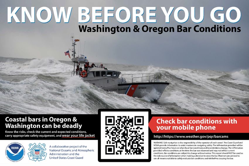
All mariners should be familiar with the International Distress Signals and procedures, for recognition, self-reliance
or in the event of distress where the captain and officers may have been incapacitated. Short-range distress signals,
limited in range of visibility or audibility, are:
1. "SOS" (. . . --- . . .) signal made by audio or visual means.
2. International Flag Code "NC" (November Charlie flag hoist).
3. Hoisting any square flag with a ball, or anything resembling a ball, above or below it.
4. Flames made visible (as burning oil in a barrel).
5. A meteor, parachute or hand held flare showing a red light.
6. Rockets or shells, throwing red stars, fired one at a time in short intervals.
7. Orange smoke as emitted from a distress flare.
8. A gun or other explosive device fired at about one minute intervals.
9. Continuous sounding of any fog signal device.
10. Slowly and repeatedly raising and lowering arms outstretched to each side.
11. (EPIRB) signals transmitted by emergency position indicating radio beacons.
12. A signal sent by radiotelephone consisting of the spoken word "MAYDAY".
13. Radiotelegraph alarm signal.
14. Radiotelephone alarm signal.
15. A high intensity white light flashing at regular intervals from 50 to 70 times per minute (Inland Waters only).
The preceding distress signals are contained in the Navigation Rules Rule 37 and described in Annex IV of the
Navigation Rules and Regulations Handbook. Available online at the United States Coast Guard Navigation Center
website: https://www.navcen.uscg.gov/index.php?pageName=NavRulesAmalgamated
RENDERING OF ASSISTANCE
The master or person in charge of a vessel is obligated by law to provide whatever assistance can be safely provided
to any individual at sea in danger of being lost, and is subject to a fine and/or imprisonment for failure to do so (Title
46 USC 2304).
RADIOTELEPHONE (VOICE) DISTRESS MESSAGE
Periodically, mariners in distress or having knowledge of another vessel in distress do not give all the information
required by the International Radio Regulations and by the Federal Communications Commission. This often makes
it impractical to start a search and could very well lead to loss of life. Use of proper format is vital in the
transmission of marine distress messages. The urgency of the situation places a premium on brevity and clarity.
The Coast Guard strongly recommends that all mariners learn the distress message format and transmission
procedures.
1. SPEAK SLOWLY AND CLEARLY
If you are in DISTRESS (i.e.: when threatened by grave and imminent danger) transmit the International Distress
Call on VHF-FM Channel 16 (156.8 MHz) - MAYDAY MAYDAY MAYDAY THIS IS (your vessel's call sign
and name repeated not more than THREE times). If you need information or assistance from the Coast Guard
(other than in a distress) call COAST GUARD on VHF-FM Channel 16 (156.8 MHz) (the DISTRESS and
CALLING FREQUENCIES). In this situation, you will normally be shifted to a common working frequency
allowing the DISTRESS frequencies to remain open.
Emergency Procedures 1 of 8 Chapter I
2.   IF ABOARD A VESSEL IN DISTRESS OR DIFFICULTY – PROVIDE:
      If you are the master, crew, or passenger on a vessel in immediate danger, contact assistance by the most rapid
      means available (radio, cell phone, signal device, etc.). Be prepared to provide:
      a. LOCATION:
           Provide the GPS coordinates of your location. If these are not available, provide the most recently logged
           GPS position or the ship’s position relative to a geographic point with as much detail as possible. For
           example, saying “80 nautical miles at 250 degrees true from the mouth of the Columbia River” is better
           than “due west of the Columbia River.”
      b. NUMBER OF PERSONS ON BOARD:
           You will be instructed to get them into personal flotation devices (lifejackets).
      c. VESSEL DESCRIPTION & NAME:
           Provide your vessel’s physical description (length, type, cabin, masts, power, hull color, superstructure
           and trim) and name.
      d. NATURE OF DISTRESS:
           Provide the reason assistance is needed. This is critical in assisting responders with determining whether
           or not they need to bring specialized equipment such as pumps, firefighting foam, medical personnel, etc.
           Once this information has been passed to the Coast Guard, be prepared for the following:
                   a. If you are calling in from a cell-phone you will be asked for that phone number and how much
                   time you have left on your battery.
                   b. If you are calling on VHF-FM Channel 16, you may be switched to a separate Coast
                   Guard working frequency. You will likely be placed on a communications schedule while
                   waiting for assistance to arrive.
                   c. You will be asked to confirm that all persons on board have donned personal flotation devices
                   (life jackets).
                   d. You will likely be asked to report the seaworthiness of your vessel (leaking, compartments
                   flooded, source of flooding, etc.).

 3. IF OBSERVING ANOTHER VESSEL IN DISTRESS OR SHOWING SIGNS OF HAVING DIFFICULTY –
    PROVIDE:
     a. Your position, and (if possible) the bearing and distance from a point of land, or GPS readings of the vessel
        in distress or difficulty.
     b. Nature of distress or difficulty.
     c. Description of the vessel in distress or difficulty.
     d. Your intentions, course, and speed, etc.
     e. Your radio call sign, name of your vessel, listening frequency and schedule.
     f. Cell phone number.

 The Distress Call has absolute priority over all other transmissions and shall not be addressed to any particular
 station. Any mariner hearing a Distress Call shall immediately cease all transmissions which may interfere with the
 distress message and shall continue to listen on the frequency on which the call was heard. If your vessel is in
 distress and abandonment is necessary, the radio transmitter should be set for continuous emission if possible, to
 provide rescue vessels and aircraft with a homing signal.

 DO NOT USE MAYDAY TO REPORT THAT YOUR VESSEL IS OUT OF GAS, DISORIENTED, OR
 HAVING ENGINE TROUBLE UNLESS YOU ARE IN IMMEDIATE DANGER.

Emergency Procedures                                    2 of 8                                                Chapter I
4. IF YOU HAVE A MEDICAL INCIDENT – PROVIDE TO THE BEST OF YOUR ABILITY:
           a. Name of vessel and/or call sign.
           b. Position.
           c. Patient's name and age.
           d. Nature of problem (symptoms, locations of pain or injury).
           e. Is patient conscious?
           f. Is patient ambulatory (able to walk)?
           g. What is the patient's temperature and pulse?
           h. Is the patient having difficulty breathing?
           i. Is patient bleeding? Is the bleeding controlled?
           j. How long has the patient been in pain?
           k. Previous similar episode (if yes, treatment and diagnosis).
           l. Medicine taken and medicine available.
           m. Private physician's name and phone number.
 5. ROUTINE COMMUNICATIONS WITH THE U.S. COAST GUARD
 VHF-FM equipped vessels are encouraged use VHF-FM Channel 22A (157.1 MHz) for non-emergency
 communications with Coast Guard units. First call the desired Coast Guard unit on Channel 16 then shift to Channel
 22A for routine communications.
 NOTE: Modern VHF-FM radios now have VHF-FM Channel 22A; however, older models might not.
 6. VISUAL DISTRESS SIGNALS (VDS)
 Below is a pictorial plate showing the different types of VDS to use or respond to in case of emergency. Remember,
 no person in a boat shall display a VDS under any circumstances except a situation where assistance is needed because
 of immediate or potential danger to a person onboard.

Emergency Procedures                                   3 of 8                                              Chapter I
7.    EMERGENCY POSITION INDICATING RADIOBEACON (EPIRB) / PERSONAL LOCATER BEACON (PLB)
 An EPIRB or PLB is a very useful piece of survival gear that has saved many lives in the Pacific. These beacons
 emits a radio signal used to locate mariners in distress. Satellites locate the position of the beacon which greatly
 increases a mariner’s chances of survival. While orbiting the earth, the satellites continuously monitor for EPIRBs
 and PLBs. When the satellites receive an emergency signal, it determines the beacon's position that is ultimately
 relayed to the nearest Coast Guard Rescue Coordination Center where rescue units are dispatched to the scene.

 NOTE: Mariners should ensure that their EPIRB/PLB is in working condition and stowed properly at all times to
 avoid non-distress emissions. Mariners are required to register their 406 MHz EPIRBs and PLBs. Mariners
 shall ensure that EPIRB registration is current at all times. Registration can be accomplished online at:
 https://www.406registration.com/ In case of accidental activation, contact Joint Rescue Coordination Center
 (JRCC) Seattle at (206) 220-7001, confirm that your vessel is not in distress and be ready to provide the beacon
 identification code (a series of letters and number that starts with ADCD or something similar).
 8. JOINT RESCUE COORDINATION CENTERS (JRCC) IN THE NORTHWEST

          Location                               Telephone No.                         Manned By
          Seattle, WA                            (206) 220-7001                        Coast Guard (US)
          Victoria, B.C.                         (250) 413-8933                        Coast Guard (CAN)
          Juneau, AK                             (907) 463-2000                        Coast Guard (US)

 9.   THIRTEENTH COAST GUARD DISTRICT SEARCH AND RESCUE STATIONS

      A. THIRTEENTH COAST GUARD DISTRICT
         1. District Command Center - Seattle                                (206) 220-7004
      B. SECTOR PUGET SOUND                                                  (206) 217-6002
           1.   Station Seattle                                              (206) 217-6750
           2.   Station Bellingham (northern Puget Sound)                    (360) 734-1692
           3.   Station Port Angeles (Strait of Juan de Fuca)                (360) 417-5990
           4.   Station Neah Bay (northern WA coast)                         (360) 645-2237
           5.   Station Quillayute River (central WA coast)                  (360) 374-6469

      C. SECTOR FIELD OFFICE PORT ANGELES                                    (360) 417-5840

      D. SECTOR COLUMBIA RIVER                                               (503) 861-6211
         1. Station Grays Harbor (southern WA coast)                         (360) 268-0121
         2. Station Cape Disappointment (Columbia River)                     (360) 642-2382
         3. Station Tillamook (northern OR coast)                            (503) 322-3531
         4. Station Portland (inland Columbia River)                         (503) 240-9365

      E. SECTOR NORTH BEND                                                   (541) 756-9220
         1. Station Depoe Bay (northern OR coast)                            (541) 765-2124
         2. Station Yaquina Bay (central OR coast)                           (541) 265-5381
         3. Station Siuslaw River (central OR coast)                         (541) 997-3631
         4. Station Umpqua River (central OR coast)                          (541) 271-2138
         5. Station Coos Bay (central OR coast)                              (541) 888-3267
         6. Station Chetco River (southern OR coast)                         (541) 469-3885

 PROCEDURES AND SIGNALS BETWEEN AIRCRAFT AND SURFACE CRAFT FOR DIRECTING
 SURFACE CRAFT TO SCENE OF DISTRESS INCIDENT

 The following procedures performed in sequence by an aircraft mean that the aircraft is directing a surface craft
 toward the scene of a distress incident:
 1.   Circling the surface craft at least once.
 2.   Crossing the bow or projected course of the surface craft close ahead at low altitude, opening and closing the
      throttle, or changing the propeller pitch.
 3.   Heading in the direction in which the surface craft is to be directed. The surface craft should acknowledge the
      signal by changing course and following the aircraft. If it is impossible for the surface craft to follow, hoist the
      international code flag NOVEMBER, or use any other signaling means available to indicate so.

Emergency Procedures                                       4 of 8                                                 Chapter I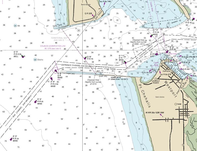
4.   If you are radio equipped, you should attempt to communicate with the aircraft on VHF-FM Channel 16
      (156.8 MHz) when the aircraft makes the above signals or makes any obvious attempt to attract your
      attention. In the event that you cannot communicate by radio, be alert for a message block dropped from the
      aircraft.

 The following procedure performed by an aircraft means that the assistance of the surface craft is no longer
 required: Crossing the wake of the surface craft close astern at a low altitude opening and closing the throttle or
 changing the propeller pitch.

 SEARCH AND RESCUE OPERATIONS

 1.   VESSEL IDENTIFICATION
      Coast Guard search-and-rescue aircraft and surface craft use radar to assist in locating disabled vessels.
      Wooden and fiberglass vessels are often poor radar targets. Operators of disabled craft that are the object of a
      search are requested to hoist, as high above the waterline as possible, a radar-reflecting device. If no special
      radar-reflecting device is aboard, an improvised device can be used. This should consist of metallic objects of
      irregular shape. The more irregular the shape, the better will be the radar-reflective quality. For quick
      identification at night, shine spotlights straight up. If aircraft are involved, once you are identified, turn lights
      away so as not to blind aircraft crew. Never use a laser pointer.

 2.   PREPARATIONS FOR TOWING
      a. All personnel put on personal flotation devices.
      b. Have bow cleared.
      c. If line-throwing gun is used, keep all personnel out of the way, until projectile clears boat.
      d. Have material (rags) handy for use as chafing gear on towline/bridle.
      e. Secure towline to a secure bitt or crucifix. Verify whether or not the fittings have backing plates.
      f. Remove heaving line.
      g. Make a drogue ready for use from your stern if your rudder cannot be controlled. Especially important
         when being towed in a following sea.
      h. All persons remain topside, low and aft while under tow.
      i. If in doubt, request additional briefing by Coast Guard boat operator.

 3.   HELICOPTER EVACUATION PROCEDURES
      The following procedures are prescribed by the Coast Guard during helicopter evacuation from a vessel. If you
      have a radio aboard, further instructions may be given by the helicopter on the voice distress frequency. As
      Captain or Boat Operator, each person on board is under your care and although the Coast Guard, doctors, and
      other agencies may assist you, each person is your responsibility. Helicopter evacuation is a hazardous
      operation to the patient and the helo crew, and should only be attempted in event of very serious illness or
      injury. Provide the doctor with all the information you can concerning the patient so an intelligent evaluation
      can be made concerning the need for evacuation. Today's helicopters CAN ONLY PROCEED UP TO 120 TO
      200 MILES off-shore for a pickup, and then only if weather conditions permit. Moreover, they have limited time
      to conduct the evacuation before fuel constraints require the helicopter to return to base. Therefore, if you have
      a victim on board and believe that an evacuation may be necessary, find a safe course and make best speed
      towards the closest Coast Guard air station. Coast Guard air stations in the Pacific Northwest are at the
      following locations:
           •   Port Angeles, Washington
           •   Warrenton, Oregon
           •   Newport, Oregon
           •   North Bend, Oregon

      a.   WHEN REQUESTING HELICOPTER ASSISTANCE
           (1) Give accurate position, time, speed, course, weather conditions, sea conditions, wind direction and
               velocity, type of vessel, and radio frequencies.
           (2) If not already provided, give COMPLETE medical information including whether or not patient is
               ambulatory (able to walk).
           (3) If you are beyond helicopter range, advise your intentions so that a rendezvous point may be selected.
           (4) If there are any changes in any plans or information, advise immediately. Should the patient expire
               prior to arrival of the helicopter, let the Coast Guard know.

Emergency Procedures                                       5 of 8                                                   Chapter I
b.   PREPARATIONS PRIOR TO ARRIVAL OF HELICOPTER
           (1) Provide continuous radio guard on VHF-FM channel 16 or specified voice frequency if possible.
           (2) Select and clear most suitable hoist area. This must include securing of loose gear, awnings and
               antenna wires. Lash up or stow running rigging and booms. The stern is highly preferred for the hoist
               area. The foredeck should be prepared only when the stern or amidships cannot possibly be used.
           (3) If the hoist is at night, light the pickup areas as well as possible. Be sure you DO NOT SHINE ANY
               LIGHTS on the helicopter that might blind the pilot and crew. If there are obstructions in the vicinity,
               put a light on them so the pilot will be aware of their positions.
           (4) Identify the location of pickup area BEFORE the helicopter arrives so the pilot may adjust for and
               make the approach aft, amidships, or forward as required.
           (5) Remember, there will be a high noise level under the helicopter, so voice communication is almost
               impossible. Arrange a set of hand signals among the crew who will assist.

      c.   HOIST OPERATIONS
           (1) If possible, have patient moved to, or as close to, the hoist area as his condition permits - THIS IS
                IMPORTANT.
           (2) Normally, if a litter is required, it will be necessary to move the patient to the special litter that will be
                lowered by the helicopter. Be prepared to do this as quickly as possible. Ensure the patient is strapped
                in, face up. If patient’s condition permits, ensure that s/he is wearing a lifejacket. Be sure patient is
                tagged to indicate what and when medication, if any, was given.
           (3) Change course to permit the ship to ride as easily as possible with the wind on the bow, preferably on
                the port bow. Try to choose a course to keep engine exhausts clear of hoist area.
           (4) Reduce speed to ease ship's motion but maintain steerageway.
           (5) If you do not have radio contact with helicopter, when you are in all respects ready for the hoist, signal
                the helicopter in with a "COME ON" by hand, or use flashlight at night.
           (6) ALLOW BASKET OR STRETCHER TO TOUCH DECK PRIOR TO HANDLING TO AVOID
                STATIC SHOCK.
           (7) If a trail line is dropped by the helicopter, guide basket or stretcher to the deck; keep line clear at all
                times. The line will not cause a shock.
           (8) Place patient in basket sitting with hands clear of sides, or in the litter, as described above. Signal
                helicopter hoist operator when ready for hoist. Patient nods head if he is able. DECK PERSONNEL
                GIVE THUMBS UP.
           (9) If necessary to take litter away from hoist point unhook hoist cable and keep free for helicopter to haul
                in. DO NOT SECURE CABLE TO VESSEL OR ATTEMPT TO MOVE STRETCHER WITHOUT
                UNHOOKING.
           (10) When patient is strapped in stretcher, signal helicopter to lower cable, and signal hoist operator when
                ready to hoist. Steady stretcher to prevent swinging or turning.
           (11) If trail line is attached to basket or stretcher use to steady (keep feet clear of line).

 4.   UNMANNED/ADRIFT PADDLECRAFT, STANDUP PADDLEBOARDs and SAILING VESSELS
 Unmanned and Adrift Paddlecraft, Standup Paddleboard and Sailing vessels, which were not properly stowed are a
 large nuisance to the Search and Rescue System. Coast Guard crews treat every unmanned-adrift vessel as a search
 and rescue case and immediately launch a search for potential mariners in distress.
 Every unmanned-adrift vessel is treated as a potential distress situation, which takes up valuable time, resources and
 manpower. When the craft is properly labeled, the situation can often be quickly resolved with a phone call to the
 vessel owner, which minimizes personnel fatigue and negative impacts on crew readiness.
 Helicopter and boat crews individually search an average of two hours per response and a similar amount of time is
 spent by other government agency personnel. Additionally, Coast Guard command center and 911 center personnel
 spend an additional four hours investigating the incident.
 Coast Guard officials encourage all paddle craft owners to label their vessels using a permanent or waterproof
 marker covered with clear, waterproof tape for increased durability. You can also check with a local outdoor
 recreation retailer or Coast Guard Auxiliary Flotilla to obtain a Paddle Smart Identification Sticker. At the very
 least, the label should include the name of the vessel’s owner, a number to reach them and a secondary point of
 contact.

Emergency Procedures                                        6 of 8                                                  Chapter I
In the event that the vessel is adrift, crews can use that information to contact the owner and avoid launching an
unnecessary search. If the owner of a vessel is unable to be located after a reasonable amount of time, Coast Guard
crews are forced to destroy the vessel or turn it over to the state for disposal.
Mariners who encounter unmanned-adrift vessels or other hazards to navigation are encouraged to contact the Coast
Guard 13th District Command Center at 206-220-7001 or via VHF-FM Channel 16.
THIRTEENTH COAST GUARD DISTRICT - NON-EMERGENCY ASSISTANCE POLICY
Boaters who find themselves in need of assistance in non-emergency situations will receive help from the Coast
Guard by either obtaining commercial assistance or directing other resources (including Coast Guard and Coast
Guard Auxiliary resources) to the scene. This policy addresses the needs of boaters in non-life-threatening
situations and is designed not to interfere with the rights of the commercial towing/assistance industry. The policy
provides that:
1. In any situation in which the mariner is in immediate distress, an immediate response will be initiated. The
Coast Guard, the Coast Guard Auxiliary, or state, local, commercial, or private resources may provide this
response.
2. If neither the mariner nor the vessel is in immediate distress and no commercial companies are known to be
available in the area, a Coast Guard resource will be dispatched.
3. If commercial towing companies operate in the area, the Coast Guard will assist the mariner in contacting any
specifically requested alternate assistance. If none is requested, an offer to issue a Marine Assistance Request
Broadcast (MARB) will be made. This broadcast will help to determine if someone in the area can come to the
assistance of the mariner.
4. If an acceptable response (capable of safely accomplishing the mission in a reasonable time) is received to the
MARB, the Search and Rescue Mission Coordinator (SMC) shall ascertain the expected time of arrival (ETA)
on scene and advise the mariner. The SMC shall continue to monitor the situation until it reaches a successful
conclusion. A reasonable response time, from initial notification to time on scene, is considered one hour or
less. In situations where the response time will exceed one hour, a Coast Guard Auxiliary resource will be
dispatched if it can provide a more timely response.
5. If no response to the MARB is received within 10 minutes, the SMC will select and proceed with the course of
action (listed below) that will result in the most effective and timely response to the mariner.
a. Dispatch an Auxiliary resource.
b. Issue another MARB.
c. Make a telephone call to any resource (including commercial providers) that may be able to provide a
timely response.
d. Dispatch a Coast Guard resource.
6. The mariner may decline the assistance offered, and the Coast Guard may make additional MARBs, but if the
first assisting resource on scene is a commercial provider, only one additional MARB will be made. A list of
telephone numbers for commercial providers in the area will be given to the mariner, upon request, so that they
may contact alternate responders through the marine operator. A Coast Guard resource will not be dispatched
unless the situation deteriorates into an emergency.
7. Once a vessel is taken in tow by a Coast Guard or Coast Guard Auxiliary vessel, it will not be turned over to
another resource unless all parties agree that the transfer can be accomplished safely or, a more urgent situation
requires the use of the Coast Guard vessel. A tow will normally be conducted to the nearest safe-haven. The
Coast Guard reminds boaters that under the non-emergency policy, the operator of a vessel needing assistance
will have to pay for commercial services. To help reduce the need for assistance, mariners are advised to ensure
that all safety equipment is on board, the vessel is in good operating condition, sufficient fuel and necessary
charts are onboard, the radio is operating properly, and someone knows the sailing plan of the operator and will
notify the Coast Guard if the vessel fails to return when expected. Questions concerning this notice should be
directed to the Thirteenth Coast Guard District, Response Branch at (206) 220-7002.
SHIP ABANDONMENT AND HYPOTHERMIA
If you are forced to abandon ship, your chances of rescue are increased if you have a pre-planned survival procedure
and follow it. Records reveal that even the quickest ship sinking usually require 15 to 30 minutes for the vessel to
fully submerge. This affords valuable time for preparation. Here are some pointers for you to remember in a
situation of this type:
Emergency Procedures 7 of 8 Chapter I1. Don as much warm, preferably non-cotton based, clothing as possible, covering head, neck, hands, and feet.
2. If an immersion (exposure) suit is available put it on over warm clothing.
3. If the immersion suit does not have inherent flotation, put on a lifejacket.
4. All persons who know that they are likely to be affected by seasickness should, before or immediately after
boarding the survival craft, take the recommended dose of some recommended preventative tablets or medicine.
The incapacitation caused by seasickness interferes with your survival chances; the vomiting removes precious
body fluid while seasickness in general makes you more prone to hypothermia.
5. Avoid entering the water if possible. Board davit-launched survival craft on the embarkation deck. If davit-
launched survival craft are not available, use ladders, or, if necessary, lower yourself by means of a rope or fire
hose.
6. Unless it is unavoidable, do not jump from higher than 5 meters (16.4 feet) into the water. Try to minimize the
shock of sudden cold immersion. Rather than jumping into the cold water, try to lower yourself gradually. A
sudden plunge into the cold water can cause death or an uncontrollable rise in breathing rate may result in an
intake of water into the lungs. On occasions it may be necessary to jump into the water, you should keep your
elbows at your sides, cover your nose and mouth with one hand holding the wrist or elbow firmly with the other
hand. One should not jump into the water astern of a life raft because the ship might be moving through the
water.
7. Once in the water, orient yourself and try to locate the ship, lifeboats, life rafts, other survivors or other floating
objects. If you were unable to prepare yourself before entering the water, button up clothing now. In cold water
you may experience violent shivering and great pain. These are natural body reflexes that are not dangerous.
Take action as quickly as possible before you lose full use of your hands: button up clothing, turn on signal
lights, locate whistle, etc.
8. While afloat in the water, do not attempt to swim unless it is to reach a nearby craft, a fellow survivor, or a
floating object on which you can lean or climb on to. Unnecessary swimming will "pump" out any warm water
between your body and the layers of clothing, thereby increasing the rate of the body-heat loss. In addition,
unnecessary movements of your arms and legs send warm blood from the inner core to the outer layer of the
body. This results in a very rapid heat loss. Hence, it is most important to remain as still as possible in the
water, no matter how painful it may be. Remember, pain will not kill you, but heat loss will.
HOW HYPOTHERMIA AFFECTS MOST ADULTS
Water Temperature Exhaustion or Expected Time of
(° F) Unconsciousness Survival
32.5 Under 15 min. Under 15 to 45 min
32.5 to 40 15 to 30 min. 30 to 90 min.
40 to 50 30 to 60 min. 1 to 3 hrs.
50 to 60 1 to 2 hrs. 1 to 6 hrs.
60 to 70 2 to 7 hrs. 2 to 40 hrs.
70 to 80 2 to 12 hrs. 3 hrs. to indefinite
Over 80 Indefinite Indefinite
9. Try to conserve body heat. Float as still as possible with your legs together, elbows close to your side and arms
folded across the front of your lifejacket, minimizing the exposure of the body surface to the cold water. Try to
keep your head and neck out of the water. Another technique is to huddle closely to one or more persons afloat,
making as much body contact as possible. You must be wearing a life vest to be able to hold these positions in
the water.
10. Try to board a lifeboat, raft, or other floating platform or object as soon as possible in order to shorten your
immersion time. Remember, you lose body heat many times faster in water than in air. Since the effectiveness
of your insulation is seriously reduced by water soaking, you must now try to shield yourself from wind to
avoid a wind-chill effect (convective cooling).
11. Do not use "drown proofing" in cold water. "Drown proofing" is a technique whereby you relax in the water
and allow your head to submerge between breaths. It is an energy saving procedure to use in warm water when
you are not wearing a life vest. However, the head and neck are high heat loss areas and must be kept above
water. That is why it is more important to wear a life vest in cold water. If you are not wearing a vest, tread
water only as much as necessary to keep your head out of the water.
Keep a positive attitude about your survival and rescue. This will improve your chances of extending your survival
time until rescue comes.
Emergency Procedures 8 of 8 Chapter ICHAPTER II
GUIDE TO HAZARDOUS BARS
REGULATED NAVIGATION AREAS (RNA); BARS ALONG THE COASTS OF OREGON AND
WASHINGTON
Each of the following areas is a regulated navigation area in accordance with 33 USC 165.1325: Quillayute River
Entrance, Wash, Grays Harbor Entrance, Wash, Willapa Bay, Wash, Columbia River Bar, Wash.-Oregon, Nehalem
River Bar, Oregon, Tillamook Bay Bar, Oregon, Netarts Bay Bar, Oregon, Siletz Bay Bar, Oregon, Depoe Bay Bar,
Oregon, Yaquina Bay Bar, Oregon, Siuslaw River Bar, Oregon, Umpqua River Bar, Oregon, Coos Bay Bar, Oregon,
Coquille River Bar, Oregon, Rogue River Bar, Oregon, Chetco River Bar, Oregon.
Passage across the bars located in regulated navigation areas will be restricted for recreational and uninspected
passenger vessels as determined by the Captain of the Port (COTP) or their designated representative. In making this
determination, the COTP or their designated representative will determine whether an unsafe condition exists.
Additionally, the COTP or their designated representative will use their professional maritime experience and
knowledge of local environmental conditions in making their determination. Factors that will be considered include,
but are not limited to: size and type of vessel, sea state, winds, wave period, and tidal currents. When a bar is
restricted, the operation of recreational and uninspected passenger vessels in the regulated navigation area is
prohibited unless specifically authorized by the COTP or his designated representative.
The bars located in the regulated navigation areas will be closed to all vessels whenever environmental conditions
exceed the operational limitations of the relevant Coast Guard search and rescue resources as determined by the
COTP. When a bar is closed, the operation of any vessel in the regulated navigation area is prohibited unless
specifically authorized by the COTP or his designated representative. The Coast Guard will notify the public of bar
restrictions and bar closures via a Broadcast Notice to Mariners on VHF–FM Channel 16 and 22A. Additionally,
Coast Guard personnel may be on-scene to advise the public of any bar restrictions and/or closures. Regulated
Hazardous Bars 1 of 22 Chapter IINavigation Area Warning Signs are diamond-shaped white warning day markers with orange reflective border and the words "ROUGH BAR" in black letters. Generally, two alternating quick flashing yellow lights are energized when there is a restriction for recreational and/or uninspected commercial passenger vessels. Lights are usually extinguished during lesser sea conditions, but this is no guarantee that the bar is safe. Regulated Navigation Area Warning Signs are located at: CHETCO RIVER, ROGUE RIVER (when staffed), COQUILLE RIVER (when staffed), COOS BAY, UMPQUA RIVER, SIUSLAW RIVER, YAQUINA BAY, DEPOE BAY, TILLAMOOK BAY, GRAYS HARBOR, and QUILLAYUTE RIVER. The operator of any recreational vessel operating in a regulated navigation area shall ensure that whenever their vessel is being towed or escorted across a bar by the Coast Guard all persons located in any unenclosed areas of their vessel are wearing lifejackets and that lifejackets are readily accessible for/to all persons located in any enclosed areas of their vessel. Operators of commercial fishing vessels should be aware that this regulation imposes reporting requirements on commercial vessels even if a bar restriction does not prohibit the operator to cross the bar. All mariners operating in a Regulated Navigation Area should be familiar with the requirements of 33 CFR 165.1325. COASTAL BAR CONDITIONS AND RESTRICTION REPORTING A system of notification to mariners has been developed to provide tools to assist boaters in making risk based decisions when evaluating their ability to cross the bar. Boaters should seek out several forms of information to make these decisions to safely evaluate weather and sea conditions for their specific size and type of vessel as well as their individual abilities as an operator. Things such as knowing the state of the tide and its effect, knowing the current forecasted weather and sea conditions as well as knowing how all those forces affect the local conditions. The U.S. Coast Guard and the National Weather service have teamed up to provide the most up to date forecasts information and sea condition observations for coastal bar conditions along the Oregon and Washington coast. Each port provides a local area radio broadcast on 1610AM that gives the current observed bar conditions and any restrictions that may be in place. This information can also be obtained by phone, dialing the port specific number found further in this section. Internet viewing of conditions and restrictions, including bar camera images, can be found at: https://www.weather.gov/pqr/barcams. For current bar conditions go to: http://www.wrh.noaa.gov/pqr/marine/BarObs.php. These observations are updated every four hours or when conditions change. The Coast Guard and NOAA provide this information to assist mariners in making sound decisions for navigating safely but the safe navigation is the responsibility of the vessel operator. The bar restrictions and conditions information provided will be updated every four hours or when local conditions change. The information provided only reflects conditions at the time the bar was observed and may not reflect current conditions and bar conditions are subject to change without notice. These reports should NOT be used as the sole source of information when making a decision to cross the bar. Mariners are advised to use all means available to safely evaluate bar conditions and risk before crossing the bar. COASTAL SEA SURFACE CONDITIONS Tides (changes in water level) are caused mainly by the gravitational pull of the sun and moon. There are roughly two tides daily in the Pacific Northwest. A flood tide is the tidal movement of water towards shore, and an ebb tide is the movement away from shore or downstream. Slack water is when there is no tidal movement. Tidal Current is the flow of water. In Washington and Oregon saltwater tidal currents can obtain considerable velocities, especially when the ebbing tide is reinforced by river runoff. COASTAL BARS The most dangerous condition occurs when swift ebb current meets heavy seas rolling in from the Pacific Ocean at a shallow river entrance (called a bar). At these coastal bars the water "piles up" and then "breaks". Even on calm days a swift ebb tide may create a bar condition that is too rough for small craft (any vessel under 65 feet). It is safest to transit from harbor to ocean only on slack water, flood tides, or when the sea state is calm. If you are inside the bar when rough conditions exist, remain inside! If you are trapped outside a rough bar on an ebb current, wait a few hours until the tide floods. In addition, waves build up at shallow areas such as sand spits and shoals. These areas are dangerous and should be avoided at all times. In a bar area, sea conditions can change rapidly and Hazardous Bars 2 of 22 Chapter II
without warning. Always cross with caution! Bar guides for the various rivers and bays of the Pacific Northwest
  are contained in this chapter. The charts of the Oregon coastal bars are provided courtesy of the Oregon Marine
  Board. They have many useful publications that can be downloaded from https://www.pacificarea.uscg.mil/Our-
  Organization/District-13/District-Staff/-dpw/.

  COAST WEATHER WARNING DISPLAYS
                                                   DAYTIME SIGNALS
  SMALL CRAFT ADVISORY                  GALE WARNING               STORM WARNING           HURRICANE WARNING

                                                NIGHT (LIGHT) SIGNALS
  SMALL CRAFT ADVISORY                  GALE WARNING               STORM WARNING           HURRICANE WARNING

  EXPLANATION OF WARNING DISPLAYS
  1.   Small Craft Advisory: To alert mariners to sustained (more than two hours) weather or sea conditions, either
       present or forecast, that might be hazardous to small boats. Mariners learning of a Small Craft Advisory are
       urged to determine immediately the reason by tuning their radios to the latest marine broadcasts. The decision
       as to the degree of hazard is left up to the mariner, based on his/her experience, and size and type of boat. The
       threshold conditions for the Small Craft Advisory are usually 18 knots of wind (less than 18 knots in some
       dangerous waters) or hazardous wave conditions.
  2.   Gale Warning: To indicate winds within the range of 34 to 47 knots are forecast for the area.
  3.   Storm Warning: To indicate winds 48 knots and above are forecast for the area. However, if the winds are
       associated with a tropical cyclone (hurricane) the Storm warning display indicates that winds 64 knots and
       above are forecast for the area.
  4.   Hurricane Warning: Issued only in connection with a tropical cyclone (hurricane) to indicate that winds 64
       knots and above are forecast for the area.

  NOTE: A "HURRICANE WATCH" is an announcement issued by the NWS via press, and radio and television
  broadcasts whenever a tropical storm or hurricane becomes a threat to a coastal area. The "Hurricane Watch"
  announcement is not a warning, rather it indicates that the hurricane is near enough that everyone in the area
  covered by the "Watch" should listen to their radios for subsequent advisories and be ready to take precautionary
  action in case “Hurricane Warnings” are issued. A SPECIAL MARINE WARNING BULLETIN is issued
  whenever a severe local storm or strong wind of brief duration is imminent and is not covered by existing
  warnings or advisories. Boaters will be able to receive these special warnings by keeping tuned to a NOAA or
  Coast Guard VHF-FM radio frequency and commercial radio stations that transmit marine weather information.

Hazardous Bars                                           3 of 22                                               Chapter II
OREGON AND WASHINGTON - COASTAL WARNING DISPLAYS
The U.S. Coast Guard continues to maintain Coastal Warning Displays at the following locations:
Station Latitude Longitude Type of Display
Chetco River Station, OR 42°02.7'N 124°16.1'W Daytime only
*Rogue River Patrol, OR 42°25.6'N 124°25.3'W Daytime only
*Coquille River Patrol, OR 43°07.2'N 124°25.0'W Daytime only
Coos Bay Station, OR 43°20.4'N 124°19.4'W Daytime only
Coos Head Lookout, OR 43°21.1'N 124°20.1'W Daytime only
Umpqua River Lookout, OR 43°40.0'N 124°12.2'W Daytime only
Umpqua River-Winchester Bay, OR 43°40.8'N 124°10.6'W Daytime only
Siuslaw River Station, OR 44°00.1'N 124°07.3'W Daytime only
Yaquina Bay Station, OR 44°37.6'N 124°03.3'W Daytime only
Depoe Bay Station, OR 44°48.6'N 124°03.5'W Daytime only
Tillamook Bay Station, OR 45°33.2'N 123°54.8'W Daytime only
Cape Disappointment, WA 46°16.7'N 124°02.8'W Daytime only
Westport, WA 46°54.3'N 124°07.2'W Daytime only
Quillayute River, WA 47°54.4'N 124°38.0'W Daytime only
Neah Bay Station, WA 48°22.3'N 124°35.8'W Day & Night
* Operational from approximately Memorial Day through Labor Day only
JETTIES
In general, jetties continue seaward for several yards past the visible end. At all times AVOID CROSSING OVER
A SUBMERGED JETTY. Navigate with extreme caution near jetties particularly when wind and sea are setting
you toward the jetty.
RANGE MARKERS (See Chartlets for location)
Front and rear range markers are rectangular-shaped dayboards are either red, green, black, or white, with a
contrasting colored center strip. (Most range markers are KRB, red with a black center stripe). For nighttime use
most range markers are lighted. By steering a course which keeps the two range markers or their lights in line with
one another, the mariner will remain within the approximate channel. Because entrance channels are constantly
shifting, the range markers do not always mark best water. The mariner, however, will remain in the approximate
channel by steering a course that keeps these range markers in line. For the most up to date information on the
location, characteristics and operating condition of range markers and all federal aids to navigation, the prudent
mariner should always consult the most recent edition of the Coast Guard Light List, Volume VI, as well as the Local
Notice to Mariners and listen to Broadcast Notice to Mariners.
SEASONAL AIDS TO NAVIGATION
Due to severe weather conditions and reduced vessel traffic during the winter, numerous aids to navigation (i.e.
lights, buoys, fog signals) are seasonally discontinued, withdrawn, or replaced by smaller aids. These changes occur
at regular intervals each year. The approximate dates are contained in the most recent edition of the Light List,
Volume VI, Pacific Coast and Pacific Islands, and on nautical charts produced by National Ocean Service. The
actual dates may be changed due to adverse weather or other conditions. Mariners should consult the Coast Guard's
Local Notice to Mariners and listen to Broadcast Notice to Mariners for the dates that seasonal changes take place.
Hazardous Bars 4 of 22 Chapter IICHETCO RIVER BAR INFORMATION DANGER AREAS A. WEST JETTY ROCKY AREA: This is dangerous because of many rocks and shoaling. At high tide the rocks are covered by water and the area appears to be navigable, but is extremely dangerous. Avoid this area at all times. B. EAST AND WEST JETTY SHOAL AREAS: These areas are extremely dangerous at all times because of submerged rocks and breakers. Rocks in these areas may be seen at low tide. Avoid these areas at all times. REGULATED NAVIGATION AREA WARNING (ROUGH BAR) SIGN: At Chetco River the sign is located on the north corner of the Coast Guard station property. If the yellow lights on this sign are flashing, a restriction has been placed on recreational and uninspected passenger vessels crossing the bar. BAR CONDITION REPORTS: For recorded bar condition and weather reports call Chetco River Coast Guard Station at (541) 469-4571. Additionally, within a three mile radius from the Coast Guard station a continual broadcast is on radio station 1610 AM containing bar conditions, bar restrictions, and local weather. Additional warning signs are located at the entrance to the boat ramp that when the amber lights are flashing you are directed to listen to 1610 AM for more information on the restriction. Bar conditions are also broadcast by radio station KURY (910 kHz) every hour during the summer daylight hours. Hazardous Bars 5 of 22 Chapter II
ROGUE RIVER INFORMATION
  DANGER AREAS
  A. SHOAL WATER, SOUTH SIDE: Alongside the south side of the Rogue River Channel are shoal water and
  gravel bars. This shoal often creates breaking waves when a swell is running. Many boats fishing inside the river,
  trolling between the jetties, find themselves set into this dangerous area by northwest winds. If a vessel breaks down
  in the channel and is not anchored, the northwest wind and ebb tide will set it into this dangerous area in a matter
  of minutes.
  B. OUTER END, NORTH JETTY: Breakers are almost always present here because of shoal water. When the
  sea is running from the west or southwest, it is particularly dangerous.
  C. OUTER END, SOUTH JETTY: Breakers are almost always present. Even when it appears calm, there may
  be occasional breakers 1,000 feet outside the south jetty. When the sea is running from the west or southwest, this
  area is very dangerous.
  FISHING INSIDE THE CHANNEL: During recent years, small boats, which do not usually go out into the ocean,
  fish just inside the bar and troll in an area between the north and south jetties. Frequently there are a great number
  of boats in this small area and they tend to crowd each other. Because trolling is the most common method of
  fishing, lines can get accidentally caught in boat propellers. Should this happen, the disabled boat should
  immediately anchor and/or call for aid. A northwest wind or ebb tide can set a boat into a dangerous area within a
  matter of minutes.
  ROGUE RIVER CHANNEL: The Rogue River channel lies between the jetty tips towards the north jetty. As of
  February 2003, the entrance channel depths were 6, 12, and 2 feet for the left outside quarter, mid-channel, and right
  outside quarter respectively. The entrance channel extends from the ocean to the inner end of the north jetty.
  Boaters are urged to use and stay within this channel. The river entrance is subject to frequent shoaling and depth
  changes. Consult the Army Corps of Engineers channel reports for the latest depths.
  REGULATED NAVIGATION AREA WARNING (ROUGH BAR) SIGN: There is a Regulated Navigation Area
  Warning Sign when the seasonal Coast Guard Station is manned. It is located on Doyle Point at the Rogue River
  Station Patrol on the north jetty. If the yellow lights on this sign are flashing, a restriction has been placed on
  recreational and uninspected passenger vessels crossing the bar.
  BAR CONDITION REPORTS: The Rogue River Coast Guard Station is activated and operational only when the
  boating activity is significant enough to warrant the patrol. For bar conditions call Chetco River Coast Guard
  Station at (541) 469-3885, or Rogue River Station at (541) 247-7219 (when seasonally open). Additionally,
  within a three mile radius from the Coast Guard station a continual broadcast is on radio station 1610 AM
  containing bar conditions, bar restrictions and local weather.

Hazardous Bars                                          6 of 22                                               Chapter II
COQUILLE RIVER BAR INFORMATION

  DANGER AREAS

  A. SOUTH JETTY: It is always dangerous to get too close to the end of a jetty. An unexpected breaker could
  carry a small boat onto the end of the jetty with great force. The inside of the south jetty is dangerous, and boaters
  should remain clear. The prevailing northwest wind could set a powerless boat onto the jetty.

  B. NORTH JETTY: Stay clear of the end of this jetty, because the sea breaks almost continuously in this area. A
  shallow area with partially submerged rocks extends from the abandoned lighthouse to the end of the jetty. Large
  swells that occur in this area could put a boat onto these rocks.

  C. SOUTH SIDE OF COQUILLE RIVER ENTRANCE: The area to the south of the entrance can be very
  dangerous. There are several rocks just below the surface that cannot be seen except during heavy seas. There is a
  prevailing northwest wind during the summer months, and the sea currents run to the south. These two conditions
  could combine to send a powerless boat into this area and onto the rocks.

  REGULATED NAVIGATION AREA WARNING (ROUGH BAR) SIGN: There is a Regulated Navigation Area
  Warning Sign when the seasonal Coast Guard Station is manned. If the yellow lights on this sign are flashing, a
  restriction has been placed on recreational and uninspected passenger vessels crossing the bar.

  BAR CONDITION REPORTS: Call the Coos Bay Coast Guard Station at (541) 888-3266, additionally, within a
  three mile radius from the Coast Guard station a continual broadcast is on radio station 1610 AM containing bar
  conditions, bar restrictions, and local weather. The Coast Guard Station on the Coquille River is activated and
  operational when the boating activity is significant enough to warrant the patrol, usually Memorial Day through
  Labor Day, and can be contacted at (541) 347-2038.

Hazardous Bars                                           7 of 22                                                Chapter II
COOS BAY BAR INFORMATION
  DANGER AREAS

  A. SAND SPIT, SOUTH SLOUGH: As you leave the Charleston Boat Basin, the South Slough Sand Spit is on
  your left. It extends north and parallel to the channel from South Slough Buoy 6 approximately 450 yards towards
  South Slough Light 4. South Slough Lighted Buoy 2 marks the north end of the sand spit. DO NOT CROSS THIS
  AREA.
  B. SUBMERGED JETTY: When you proceed out from the Charleston Boat Basin in the South Slough channel,
  and are directly between South Slough Light 4 and South Slough Buoy 5, directly ahead will be South Slough Light
  1, which marks the end of the submerged jetty. This jetty is visible only at low water. When departing the
  Charleston Boat Basin, stay to the left of Light 1 at all times.
  C. SAND SPIT, NORTH BEACH: This area is dangerous because of shoal waters and submerged jetties.
  Occasionally, on strong ebb, there will be breakers in this area. Avoid this area because of the possibility of going
  aground or striking submerged jetties and pilings. Note, too, that inbound and outbound tugs with tows, freighters,
  and so forth, pass close aboard the area and cannot stop for obstructions in the channel – including small vessels.
  D. SOUTH JETTY, GUANO ROCK AREA: This is a very dangerous area because of shoals extending out from
  the south jetty to the entrance channel. Breakers are frequently experienced from Guano Rock Lighted Whistle
  Buoy 4 extending out to just past the end of the South Jetty. Exercise extreme care in this area at all times,
  especially on ebb tides.
  E. NORTH JETTY, SUBMERGED: The North Jetty extends approximately 200 yards to the West. The outward
  end of the jetty is submerged from the visible end of the jetty out towards Coos Bay North Jetty Lighted Gong Buoy
  3. NEVER CROSS THIS AREA. There are breakers in this area most of the time. When departing the bar
  northbound, be sure to pass Coos Bay North Jetty Lighted Gong Buoy 3 before turning to the north.
  F. AREA NORTH OF COOS BAY CHANNEL LIGHTED BUOY 5: This area can be very dangerous when there
  are any large swells on the bar or during ebb tide. Freak breakers are common in this area. While vessels transit this
  area on occasion, it is strongly recommended that you never cross here.
  REGULATED NAVIGATION AREA WARNING (ROUGH BAR) SIGN: The Coast Guard has established a
  Regulated Navigation Area Warning Sign 8 feet above the water on the jetty just north of the Charleston Boat Basin.
  This is a two-part sign, facing toward the Charleston Boat Basin and toward South Slough Light 2. If the yellow
  lights on this sign are flashing, a restriction has been placed on recreational and uninspected passenger vessels
  crossing the bar.

Hazardous Bars                                          8 of 22                                                Chapter II
BAR CONDITION REPORTS: Weather and bar conditions are updated every three hours or more frequently if
  there is a significant change in weather at the Coast Guard Station in Coos Bay. This recording can be obtained by
  calling (541) 888-3102. Additionally, within a three mile radius from the Coast Guard station a continual broadcast
  is on radio station 1610 AM containing bar conditions, bar restrictions, and local weather. Additional warning signs
  are located at the entrance to the Charleston and Empire boat ramps that when the amber lights are flashing you are
  directed to listen to 1610 AM for more information on the restriction. Radio Station KBBR (1330 kHz) broadcasts
  bar conditions once each hour during the summer months. Current weather advisories are also posted at the Coast
  Guard Station in Charleston.

Hazardous Bars                                         9 of 22                                              Chapter II
UMPQUA RIVER BAR INFORMATION
  DANGER AREAS
  A. MIDDLE GROUND AND NORTH SPIT: The North Spit is to your right as you proceed down the Umpqua
  River, starting from the first rock spar jetty and long pier on the east side of the channel. The North Spit area has
  small breakers when a swell is running, and gets rougher toward the north jetty. The north spit is very dangerous
  because large breakers may come into this area from the middle ground. The north spit meets the middle ground at
  the outer end of the training jetty. The middle ground area extends from the north jetty to the north edge of the main
  channel and is dangerous because a little swell can create large breakers which can capsize a vessel. Boaters should
  not linger near the mouth of the river during ebb tide, because if their power fails, their boats could be carried out to
  sea before an anchor would be effective or oars could be put to work.
  B. NORTH AND SOUTH JETTY: The areas north of the north jetty and south of the south jetty can be very
  dangerous. Whenever breakers are observed, boaters should avoid this area.
  C. TRAINING JETTY: On the ebb tide, the current will pull boats into the jetty. Refraction waves are often
  encountered in this area, creating extremely choppy conditions.
  D. UMPQUA RIVER LIGHT 6A, OLD COAST GUARD DOCKS: Current on either the ebb or flood will often set
  boats into this area.
  REGULATED NAVIGATION AREA WARNING (ROUGH BAR) SIGN: The Coast Guard has established a
  Regulated Navigation Area Warning Sign out towards light #6 and has two rough bar warning signs located at both
  boat ramps in Winchester bay. If the yellow lights on this sign are flashing, a restriction has been placed on
  recreational and uninspected passenger vessels crossing the bar.
  BAR CONDITION REPORTS: Bar condition reports for Umpqua River are given hourly (daylight hours only) or
  as conditions change, during summer months by station personnel and recordings are available by calling (541)
  271-4244. Bar information can also be obtained by contacting Coast Guard Station Umpqua River via radio,
  VHF-FM Channel 16/22A. Additionally, within a three mile radius from the Coast Guard station a continual
  broadcast is on radio station 1610 AM containing bar conditions, bar restrictions, and local weather. Additional
  warning signs are located at the entrance to the boat ramps that when the amber lights are flashing you are
  directed to listen to 1610 AM for more information on the restriction.
  NOTE: Breaking waves can be encountered on the Umpqua River bar at any time.
  NOTE: Entrance range may not mark best water.

Hazardous Bars                                           10 of 22                                                Chapter II
SIUSLAW RIVER BAR INFORMATION

  DANGER AREAS

  A. SHOAL WATER, NORTHEAST SIDE OF CHANNEL: Has a depth of 2 to 3 feet at high tide and extends
  from Siuslaw River Channel Buoy 7 to Siuslaw River Channel Light 9 and on to Siuslaw River Channel Buoy 11.

  B. SHOAL WATER, SOUTH SIDE OF CHANNEL: Extends from Siuslaw River Channel Buoy 6 to Siuslaw
  River Channel Buoy 4 and approximately 50 yards out toward the south jetty tips.

  C. OUTER END OF SOUTH JETTY: Breakers are almost always present in this area. When the seas are from the
  southwest or west, breakers may extend to the entrance buoy, Siuslaw River Approach Lighted Whistle Buoy S.

  D. OUTER END OF NORTH JETTY: Breakers are almost always present in this area. When the seas are from the
  west, the breakers may extend to the entrance buoy (Lighted Whistle Buoy “S”).

  SIUSLAW RIVER BAR: Siuslaw River Bar has a very narrow channel extending out past the jetties. Unlike the
  larger bars on the Oregon Coast, the Siuslaw River Bar may be rendered impassable for small boats by a moderate
  swell, particularly at ebb tide. Boaters should use extreme caution when operating near this bar. Due to shoaling and
  jetty extensions, bar conditions are unpredictable. When the bar is rough, expect continuous breakers just inside the
  jetty tips out to 250 yards.

  NOTE: The entrance range may not mark best water due to the changing conditions of the bar.

  REGULATED NAVIGATION AREA WARNING (ROUGH BAR) SIGN: At Siuslaw River the sign is mounted
  on the Coast Guard lookout tower and faces 150° True. If the yellow lights on this sign are flashing, a restriction
  has been placed on recreational and uninspected passenger vessels crossing the bar.

  BAR CONDITION REPORTS: Recorded bar and weather conditions can be obtained by calling Coast Guard
  Station Siuslaw River at (541) 997-8303. Additionally, within a three mile radius from the Coast Guard station a
  continual broadcast is on radio station 1610 AM containing bar conditions, bar restrictions, and local weather. An
  additional warning sign is located at the entrance to the boat ramp in Florence that when the amber lights are
  flashing you are directed to listen to 1610 AM for more information on the restriction.

Hazardous Bars                                         11 of 22                                              Chapter II
You can also read