The global geoheritage significance of the Kimberley Coast, Western Australia
←
→
Page content transcription
If your browser does not render page correctly, please read the page content below
Journal of the Royal Society of Western Australia, 94: 57–88, 2011

             The global geoheritage significance of the Kimberley Coast,
                                 Western Australia

                                                   M Brocx1 & V Semeniuk2
                                  1
                                      Department of Environmental Science, Murdoch University,
                                                    South St., Murdoch, WA, 6150
                                                 2
                                                   V & C Semeniuk Research Group
                                               21 Glenmere Rd., Warwick, WA, 6024

                                         Manuscript received: November 2010; accepted April 2011

                                                              Abstract
              The Kimberley Coast in north-western Australia is of global geoheritage significance. It is a
           large-scale ria coast, with a well developed intricate indented rocky shoreline, with local nearshore
           islands (archipelago), and a distinct suite of coastal sediments. In addition to its intrinsic
           geoheritage values, its unique geological and geomorphological features are found in an unspoiled
           wilderness setting in which the ensemble of natural processes are still operating. The Kimberley Coast is
           cut into Precambrian rocks: the sandstones and basalts of the Kimberley Basin and, in the southern
           areas, into folded sedimentary rocks and metamorphic rocks of the King Leopold Orogen. The
           rocks of the region are well exposed along the shore to providing a global classroom by which to
           study the region’s stratigraphy, structure, and lithology. The coastal forms in the Kimberley region
           have been determined by the structure and lithology of regional geology, interfaces between major
           geological units, by marine inundation of onshore landforms, and by the sizes, shapes and
           configuration of rivers, creeks, their tributaries, and other valley tracts in the region. The coast,
           however, is not just a continuous rocky shore composed of cliffs, and cliffs with benches, as it also
           has local sediment-filled gulfs and embayments, cliff shores fringed by mangroves, cliff shores
           with bouldery ribbons in the tidal zone, and stretches of beaches, and in the embayments, muddy
           tidal flats, spits, cheniers, tidal creeks cut into the tidal flats, and (embayment-head) alluvial fans.
           Locally, the coast is composed of algal reefs and coral reefs, beach rock, and various types of
           tempestites.
              The Kimberley Coast presents several features of geoheritage significance: 1. with ~ 700 km of
           (simplified) coastal length, it presents the best and most extensive expression of ria morphology in
           Australia, and also one of the best developed globally; 2. the occurrence of the shore in a monsoonal
           subhumid/humid tropical macrotidal setting, with processes distinct to this setting; as a tropical-
           climate ria, in terms of size and morphology, it is globally unique; 3. the morphology of the shores,
           variable in form in response to the grain of the country (viz., the Kimberley Basin versus the King
           Leopold Orogen) and lithology; 4. variation of rocky shores along its length in terms of mesoscale
           shore types; 5. the sedimentary packages that occur in the region; 6. mangrove-lined rocky shores
           and embayed shores, with the latter also related to freshwater seepage; and 7. biogenic and
           diagenetic coasts.

           Keywords: Kimberley Coast, ria coast, tropical coast, macrotidal, Proterozoic rocks, geoheritage

                      Introduction                                      Jagla & Rojo 2002; Brocx & Semeniuk 2007), ironically,
                                                                        the Kimberley Coast, the largest rocky coastline in
   Globally, only a few coasts have been described and                  Australia and one of the most distinctive ria coasts
assessed as to their geoheritage significance and this                  globally, before now, has not been formally described
paper provides an opportunity to describe the Kimberley                 and assessed for its geoheritage value.
Coast of Western Australia (Fig. 1) and address its
geoheritage significance from an International and                         Interestingly, because it is an extensive and essentially
National perspective. While there have been studies and                 a single coastal unit, the Kimberley Coast challenges
geoheritage assessments of some rocky coasts in                         many concepts in natural science and classification in the
Australia of National or of State-wide significance (e.g.,              coastal zone. For instance, the essence of what is a “ria
Hallett Cove in South Australia, The Twelve Apostles in                 coast” in plan form and relief is tested here, and the
Victoria, and Ulladulla cliffs and platform in New South                extremes of coastal types that constitute “ria shores” are
Wales; Packham 1969; Parkin 1969; Dexel & Preiss 1995;                  present in this one region. For instance, geometrically,
White et al. 2003) and overseas (e.g., Siccar Point in                  because of the regional geology, the ria coast of the
Scotland, The Seven Sisters of southern England, the                    Kimberley region grades from classic narrow ravines and
Giant’s Causeway in Ireland; Gallois 1965; Melville &                   inundated riverine valleys (traditionally, the most
Freshney 1982; Soper 1984; Bennett 1989; Sale et al. 1989;              accepted notion of a ria) to broader embayments
                                                                        (indented coasts) to marine-inundated ridge-and-basin
                                                                        topography (also termed ridge-and-valley topography;
© Royal Society of Western Australia 2011                               Fairbridge 1968a). Apart from geomorphic

                                                                   57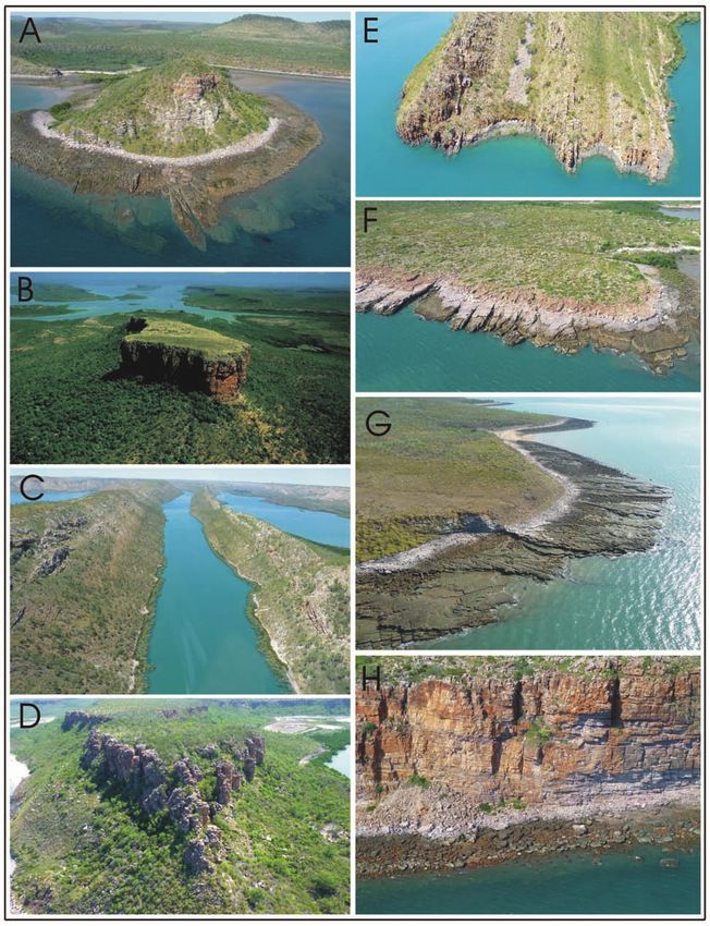
Journal of the Royal Society of Western Australia, 94(2), June 2011

                                                                       There are several ways of viewing the length of the
                                                                    Kimberley Coast. Using a simplified over-arching
                                                                    measure, it has a length of ~ 700 km. This is the measure
                                                                    used to compare other ria coasts elsewhere in Australia
                                                                    and globally. A more detailed measure involves adding
                                                                    the interior lengths of embayments, inlets, and large
                                                                    bays. From this perspective, the Kimberley Coast has a
                                                                    length of ~ 4000 km.
                                                                       This paper is based on a combined 50 years of study
                                                                    in the Kimberley region by the authors. The sites
                                                                    described in this paper have been examined by field
                                                                    work, involving boat-work, land-based vehicle access,
                                                                    aerial surveys by fixed wing aircraft, and helicopter. All
                                                                    surveys were accompanied by intensive documentary
                                                                    photography. Additional work was carried out by
                                                                    desktop aerial photographic studies. On-site studies
                                                                    involved description of coast as to form and lithology,
                                                                    sampling of sediments, and determination of Quaternary
                                                                    stratigraphy by augering and from cliff exposures.
                                                                    Samplings sites, and flight paths for fixed wing aircrafts
                                                                    and helicopters are shown in Figure 2.

                                                                                     What is a ria coast?
                                                                       In the literature there has been debate about what
                                                                    constitutes a ria and a ria coast (Johnson 1919; Cotton
                                                                    1956; Fairbridge 1968b; Castaing & Guilcher 1995; Evans
                                                                    & Prego 2003). The term “ria” originates from the
                                                                    Spanish ria (from rio, or “river”). The term derives from
Figure 1. Location map of the study area.                           describing the large narrow inlets on the coasts of Galicia
                                                                    (Fig. 3), north-western Spain (such as the Ria de Arosa
                                                                    and the Ria de Muros y Noya), being former valleys that
considerations, the Kimberley Coast, as a rocky shore,
                                                                    were submerged by relative sea level rise due to
also uniquely exhibits along hundreds of kilometres of
                                                                    eustatism or by submergence. Richthofen (1886) first
shore extensive outcrop of Precambrian rock that
                                                                    defined a ria as a marine-inundated valley cut parallel to
indicates relative tectonic stability since the Proterozoic,
                                                                    a regional geological strike transverse to a coast.
and a contact along sea cliffs between a Proterozoic
                                                                    However, to date, the term ria has carried with it a
sedimentary basin and a Proterozoic tectonic zone (now
                                                                    number of implications and misapplications. For
an orogen). Additionally, the coast resides in a tropical
                                                                    instance, while the term carries connotations of a river
monsoonal and generally macrotidal environment, with
                                                                    valley, there are ria systems, identified globally, which
a strong inter-annual influence of cyclones, factors not
                                                                    are not river valleys, but inundated ridge-and-basin
comparable to ria coasts developed elsewhere in the
                                                                    landforms (e.g., south-west Ireland), where the geological
world, with the consequence that coastal forms and
                                                                    (structural) grain is transverse to the coast (Richthofen’s
products developed here are unique to this region.
                                                                    original definition). Fjords (marine-flooded glacially cut
Finally, the coast is geomorphically varied in its
                                                                    valleys) are excluded from the river valley concept of ria,
orientation so that different parts of the coast are subject
                                                                    yet some fjords have alternated from being glacially
differentially to the coastal processes of tides, wind,
                                                                    carved to fluvially incised. Some authors, however,
wind-waves, swell, and cyclones such that, even though
                                                                    include fjords where the term ria has come to mean any
the geology is relatively simple and generally uniform
                                                                    marine-inundated valley. The use, misapplication,
from a regional perspective, there is significant
                                                                    extension, and strict application of the term ria, were
sedimentary heterogeneity.
                                                                    discussed by Cotton (1956), separating “ria sensu stricto”
   This paper is an account of the Kimberley Coast in               and “ria sensu lato”, with an argument centred on the rias
Western Australia, with a description of the coastal                of Galicia on the coast of Spain, which, though
forms, the reasons underpinning the development of the              comprising the original etymology of ria, do not
various coastal types, and the geoheritage significance of          themselves meet the definition sensu stricto. More modern
the coast at International and National level. However, in          usage has modified the definition (see below) such that
order to put the Kimberley Coast, as a ria coast, into              the term “ria” is now a synonym for any marine-
geoheritage perspective, several matters are first                  inundated valley without any structural constraint. As
discussed: the concept of ria coast, the theory                     marine-inundated river valleys, rias generally have a
underpinning geoheritage, the scope and scale of features           dendritic to trellis pattern, reflecting the nature of the
of geoheritage significance, the levels of significance             drainage of the ancestral rivers (Fig. 3), and remain open
afforded to geoheritage sites, coastal classification in            to the sea (e.g., Chesapeake Bay, United States of
relation to geoheritage, and methods of inventory-based             America; and Port Jackson, New South Wales).
site-identification and assessment.

                                                               58
Brocx & Semeniuk: Geoheritage significance of the Kimberley Coast

Figure 2. Sampling sites and place names mentioned in text.

   Jackson (1997), drawing on a history of the use of the           numerous rias produced by marine inundation of a land
term, describes a ria as any long, narrow, sometimes                margin subaerially dissected by numerous river valleys
wedge-shaped inlet or arm of the sea (but excluding a               (Johnson 1919).
fjord) whose depth and width gradually and uniformly                   Bird (2005) also provides an overview of the concepts
diminish inland, and which is produced by marine                    of rias and ria coasts, and describes a ria as a long, narrow,
inundation due to submergence of the lower part of a                often branching inlet formed by marine submergence of
narrow river valley or of an estuary. As such, it is                the lower parts of a river valley that had previously been
shallower and shorter than a fjord. Jackson (1997) also             incised below present sea level. Bird (2005) notes that
notes that originally the term was restricted to inlets             rias are the inundated mouths of unglaciated valleys,
produced where the trend of rock structure is transverse            usually bordered by steep slopes rising to mountains,
to the coastline, but was later applied to any submerged            hills, or plateaux. Clearly, fjords are excluded from the
land margin that is fluvially dissected transversely to the         definition. There is also implication that rias are
coastline. Less restrictively, a ria is defined as any broad        developed in a range of geomorphic settings from deeply
or estuarine river mouth, including a fjord, but not                incised valleys (i.e., bordered by steep slopes) to
necessarily an embayment, produced by partial                       moderately incised valleys (i.e., bordered by hills). Bird
submergence of an open valley. In this context, following           (2005) cites the long, straight valley-mouth gulfs on the
Jackson (1997), a ria coast, building on the concept of a           south-west coast of Ireland (Fig. 3) as examples of rias –
singe ria, is one having several long parallel rias                 these follow a geological strike that runs transverse to
extending far inland and alternating with ridge-like                the general coastline (a ria according to Richthofen 1886),
promontories (e.g., the coasts of south-western Ireland or          and notes that where rivers have cut valleys across
north-western Spain). Similarly, a ria shoreline comprises

                                                               59
Journal of the Royal Society of Western Australia, 94(2), June 2011

                                                                       the persistence of the ria in the mouth of Johore River in
                                                                       southeastern Malaysia, which remains a wide and deep
                                                                       inlet, whereas other Malaysian valley mouths have been
                                                                       infilled as alluvial plains, some with protruding deltas.
                                                                       Other rias persist because they were initially deep and
                                                                       sedimentary filling has been slow, as along the New
                                                                       South Wales coast (Roy 1984). In other respects,
                                                                       axiomatically, ria coasts can grade into deltaic coasts,
                                                                       estuarine coasts, and rocky shores with indentations.
                                                                       There are also complications in the concept, definition,
                                                                       and origin of a ria where existing rias have formed by
                                                                       marine submergence during the Holocene transgression
                                                                       but, as noted above, there have been several phases of
                                                                       valley incision during Pleistocene low sea-level phases,
                                                                       alternating with earlier ria formation during interglacial
                                                                       marine transgressions.
                                                                          Although the definition of ria can be broadly
                                                                       translated to mean “river-valley marine inlet”, generally
                                                                       to date, it has not comprehensively and descriptively
                                                                       included the type and relief of the terrain that has been
                                                                       inundated (cf., review in Fairbridge 1968b). As a result,
                                                                       whether the marine-inundated river valley is deeply and
                                                                       narrowly incised (involving ravines and gorges), deeply
                                                                       and broadly incised, moderately incised, or bordered by
                                                                       a hinterland of relative low-relief, is unexplored. Thus,
                                                                       for example, without more refined designation as to
                                                                       “type of ria”, or “type of ria coast”, a low relief fluvially
Figure 3. Rias from Galicia (Spain), south-western Ireland, and        incised landscape, a moderate to high relief fluvially
Sydney (NSW). Bar scale 50 km                                          incised landscape, and a distributary channel system of a
                                                                       former abandoned Pleistocene delta, particularly if it is
                                                                       uplifted, strictly, would all qualify to be termed ria coast,
geological structures there may be tributaries that follow             and there is no current comprehensive system of
the geological strike, submerged to form a trellis pattern,            descriptors or protocol to separate the types.
as in Cork Harbour in southern Ireland. Another classic
example of a ria coast following the definition of                         In the context of the review above, the coastal form of
Richthofen (1886) occurs along the Dalmatian coast of the              the Kimberley shores exhibit particular types of ria coast.
Adriatic Sea where rias are elongated marine straits                   Not consisting of isolated individual rias such as
along valleys that follow the geological strike, linked to             occurring along the coast of southern United Kingdom
the sea by transverse channels.                                        (e.g., Kingsbridge Estuary in England), or Chesapeake
                                                                       Bay in the United States of America, the Kimberley Coast
   Ria coasts around the world vary in size, shape and                 presents a ria coastline, consisting of innumerable rias of
geology and, moreover, vary with respect to the relief of              various sizes, shapes, and orientations. For much of its
the adjoining hinterland. However, to date, no author                  length the Kimberley Coast is strictly a marine-inundated
has delineated a size limit or a size range to a ria. The              river-cut landscape, comprised of marine-inundated river
type sites of rias referred to by Richthofen (1886), Cotton            valleys and fluvially-cut ravines of varying sizes, depths,
(1956), Bird (2005), amongst others, suggest dimensions                and valley orientation, widening towards seawards.
in the order of several to tens of kilometres in length and            These rias are filled with sediment to varying extent. For
hundreds of metres or several kilometres in width at the               its south-western sector, however, the Kimberley Coast is
mouth. However, with inundation of tributaries of a river              a transverse ria coast (the Irish model) where the coastal
drainage system there will be decreasing size of inlets                morphology is the result of inundation of a ridge-and-
(rias) up-stream in a branching ria system. In this context,           basin topography developed from a fold belt oriented
there should be no size limit to the definition of a ria, as           transverse to the coast. The Kimberley Coast also exhibits
the marine inundation of a river valley system can take                marine-inundated landscapes with trellis drainage
place in both a highly branched system of a large river,               patterns, that are part of the ria suite (because they are
with a wide range of valley sizes along the drainage                   part of the fluvial drainage network that has been
network, or in a small river. If a smaller tributary of a              marine-inundated) but that are near-landlocked
large river, where marine-inundated, is considered to be               embayments and narrow inlets not fully open to the sea
part of the ria system, then an isolated marine-inundated              and/or not widening to the sea as would be expected in
small river should also be considered to be a ria, albeit a            the traditional notion of a fluvially developed ria. These
small ria.                                                             rias vary in orientation from coastal-transverse, to
   As noted by Bird (2005), rias can vary in complexity of             coastal-oblique, to coastal-parallel yet all are marine-
origin. For instance, the Galician rias are generally wide             inundated interconnected fluvial valley systems. As such,
and deep marine inlets in valleys which may have been                  the coastal landscapes of the Kimberley Coast carry the
shaped partly by tectonic subsidence and the recession of              notion of what constitutes a ria coast to an extreme of its
bordering scarps. Subsidence has probably contributed to               definition and presents a wide range of intergradational

                                                                  60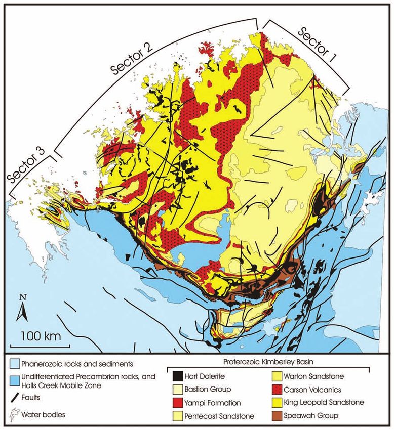
Brocx & Semeniuk: Geoheritage significance of the Kimberley Coast

coastal forms of ria expression from megascale to                        • type examples, reference sites or locations for
microscale (the largest scale to small-scale), and from rias               stratigraphy, fossils, soil reference profiles, mineral
open and widening to the sea (sea-oriented in their gulf                   sites, and geomorphic sites, including locations for
form) to those that are marine-inundated narrow                            teaching, research, and reference;
(fracture-controlled) ravines to those that are near land-               • cultural sites, e.g., where classic locations have
locked and land-oriented in their mouth. A summary of                      been described;
the types of rias developed along the Kimberley Coast,
ranging from marine-inundated fluvially incised valleys                  • geohistorical sites where there are classic
to marine-inundated fracture valleys, will be described                    exposures in cliff and outcrops where the history
later to illustrate the scope of what constitutes a ria and a              of the Earth can be reconstructed, or the processes
ria coast in this paper.                                                   within the Earth in the past can be reconstructed;
                                                                         • modern, active landscapes where dynamic
                                                                           processes are operating.
  Background theory of geoheritage – scope,
      scale, and assessing significance                                   Coastal geoheritage pertains to matters of geoheritage
                                                                       and geoconservation specifically in the coastal zone, an
   Prior to identifying and assessing sites of geoheritage             interface on the Earth’s surface that is rich in geological
significance along the Kimberley Coast, some                           and geomorphic processes and products because of the
background information is provided below, in terms of                  interaction geomorphically, sedimentologically,
the theory underpinning geoheritage, classification of                 hydrochemically, biologically, and diagenetically,
coasts to identify geodiversity of sites to assess                     between land, sea, freshwater, and atmosphere (Brocx &
geoheritage significance, the global approach of                       Semeniuk 2009b).
inventory-based site-identification and assessment, and
                                                                          Scale is important to consider in geoheritage and
the approach that has been designed in Western
                                                                       geoconservation because sites can range from landscapes
Australia to identify sites of geoheritage significance (i.e.,
                                                                       and geological phenomena at montane-scale and orogen-
applying a Geoheritage “tool-kit”).
                                                                       scale to that of outcrops, bedding planes, or a crystal,
   Globally, geoheritage (the recognition of the heritage              viz., megascale, macroscale, mesoscale, microscale, and
values of geological features) has become important                    leptoscale (Brocx & Semeniuk 2007). In many locations
because it has been established that Earth systems have a              globally, geological sites are important because of crystal-
story to tell, and that they are linked to the ongoing                 sized phenomena and crystal fabrics, because it is often
history of human development, providing the resources                  at this scale that the story of the Earth unfolds. At the
for development, and a sense of place, and have                        next scale in increasing size, features of geoheritage
scientific, historical, cultural, aesthetic, and religious             significance, represented by outcrops and bedding scale
values (Brocx & Semeniuk 2007; Brocx 2008). In addition,               features, include fossil sites, or Hutton’s unconformity at
Earth systems are the foundation of all ecological                     Siccar Point (Brocx & Semeniuk 2007). Important
processes, and part of the heritage of our sciences                    geological and geomorphological features continue to
(Torfason 2001). Geoheritage and geoconservation have                  occur in increasing scale, right up to the scale of
become a significant means for preserving geological                   mountain ranges, extensive landforms, and major
features of importance and can range in scale from very                drainage basins, such as Monument Valley Utah/
large to fine scale, in significance from International to             Arizona, or The Grand Canyon in Arizona (Holmes 1966;
local, and can encompass a wide range of geological/                   Shelton 1966).
geomorphological features, or occur in isolation, or as an
                                                                          In this paper, the classification of coasts (Brocx and
inter-related suite that should be conserved as an
                                                                       Semeniuk (2010b) and the Geoheritage “tool-kit” (Brocx
ensemble. A Geoheritage tool kit was designed to
                                                                       and Semeniuk 2009, 2010a), has been used to identify
systematically address and assess this geodiversity
                                                                       and assess the geoheritage significance of the Kimberley
(Brocx & Semeniuk 2009a, 2010a).
                                                                       Coast, using the descriptors for scale, i.e., from megascale
    Since geoheritage and geoconservation are concerned                to leptoscale, as a means of assessing geoheritage
with heritage and conservation of matters geological, then             significance, in association with criteria for levels of
all components of geology should be encompassed under its              significance as follows::
umbrella. The term geoheritage is used as follows (Brocx
                                                                         • International: one of, or a few, or the best of a
& Semeniuk 2007):
                                                                           given feature globally;
   Globally, Nationally, State-wide, to local features of
                                                                         • National: though globally relatively common, one
   geology, such as its igneous, metamorphic,
                                                                           of, or a few, or the best of a given feature
   sedimentary, stratigraphic, structural, geochemical,
                                                                           Nationally;
   mineralogic, palaeontologic, geomorphic, pedologic, and
   hydrologic attributes, at all scales, that are intrinsically          • State-wide/Regionally: though globally relatively
   important sites, or culturally important sites, that offer              common, and occurring throughout a Nation, one
   information or insights into the formation or evolution                 of, or a few, or the best of a given feature State-
   of the Earth, or into the history of science, or that can               wide or Regionally; and
   be used for research, teaching, or reference.                         • Local: occurring commonly through the world, as
   The scope of geoheritage also involves identifying                      well as Nationally to Regionally, but especially
different categories of geoheritage significance, and all                  important to local communities.
these categories can be recognised in the coastal zone
(Brocx & Semeniuk 2007):

                                                                  61
Journal of the Royal Society of Western Australia, 94(2), June 2011
Coastal classification for purposes of identifying sites or The classification of coastal types is not fixed to scale,
features of geoheritage significance and the various types are related to scale by a descriptor
Identifying sites or features of coastal geoheritage (Brocx & Semeniuk 2010b).
significance requires a number of steps beginning with
classification of coastal geology and geomorphology and Identification of sites or features of geoheritage
geoheritage category. As discussed by Brocx & Semeniuk significance
(2010b), classifying coasts for geoheritage purposes is There are a number of ways that sites of geoheritage
difficult due to the complexity, intergradation, and significance may/can be identified. The literature
different scales at which coastal features are expressed, provides a history of how this has been achieved, with a
with variation potentially present locally or regionally, focus generally on significant geological features present
and with variation in expression of outcrop and cultural/ in inland sites, or with a focus on geological content for
historical content. While geological region and science and education, or themes, with the final outcome
environmental setting play major roles in determining being that globally, an ad hoc approach for conserving
regional variation in coastal form and coastal products, sites of geoheritage significance has been, or is being,
or expression of geological content, coasts at the local replaced with an inventory-based approach (Doyle et al.
scale commonly are expressions of a gradation of 1994; Wimbledon et al. 1995, 2000; Wimbledon 1996;
processes from (marine) inundation, to erosion, to Fuertes-Gutiérrez & Fernández-Martínez 2010; for
deposition. Biogenic activity and diagenesis also play a discussion see Brocx 2008). For instance, since 1949, the
role in forming coasts though they tend to be assessment and subsequent selection of sites in the
subdominant to the other processes. To address this United Kingdom has been undertaken on the basis of a
geodiversity, coasts are classified by Brocx & Semeniuk series of blocks which may be based on time, subject or
(2010b) according to the products formed by the coastal regional divisions, or combinations thereof. Building on
marine five processes, i.e., marine inundation, erosion, this process, in 2001–2002 ProGEO contributed to a
sedimentation, biogenesis, and diagenesis. However, number of important geoconservation initiatives that
some coasts are significant because they illustrate ancient included the incorporation of a policy statement relating
geohistorical sequences, or manifest Holocene history to the importance of geology and physical landscapes in
geomorphically and stratigraphically. Twelve types of the Pan-European Biological and Landscape Diversity
coastal forms and/or geological features developed in the Strategy, and an alliance with the International Union of
coastal zone have been identified by Brocx & Semeniuk Geological Sciences and UNESCO for the purpose of
(2010b): compiling a European inventory for the Geosites project
Type 1 landforms developed by the post-glacial (ProGEO 2002a, 2002b, 2002c).
marine inundation of pre-existing landforms A systematic inventory-based approach to geoheritage
(the primary pre-inundated landscape is still and geoconservation requires a procedure, and
evident) identifying geological regions and what comprises the
Type 2 landforms developed by marine inundation of “geological essentials” of those regions provides the first
pre-existing landforms and coastal erosion of step to developing such a procedure in order to identify
the bedrock geology, or hinterland landforms the fundamental geological features for geoheritage/
geoconservation (Brocx and Semeniuk 2010a). Clearly not
Type 3 landforms wholly developed by coastal
all aspects of geology of the Earth are present in the one
erosion, or where erosion has totally or nearly
region, and clearly not all aspects of the geology of a
totally overprinted primary (pre-transgression)
given region will be of geoheritage significance – the
hinterland landforms
former, for instance, recognises the unique occurrence,
Type 4 coasts developed by the exhumation or rarity, or representativeness of some geological features,
isolation of older landforms and their and the latter requires some measure of assessment of
geological features significance.
Type 5 coastal landforms developed by marine The Geoheritage tool-kit, illustrated in Figure 4,
inundation and sedimentary infilling provides the procedure to identify geological components
Type 6 landforms wholly constructed by coastal across various geological sub-disciplines and at various
sedimentary processes that have been active scales, to assign geological sites to various conceptual
during the Holocene categories of geoheritage, and to assess the levels of
Type 7 landforms constructed by Holocene coastal significance of the various geological features (Brocx &
sedimentary processes that have superimposed Semeniuk 2009; 2010a). These concepts assume that the
erosional features wider definition of what constitutes ‘geoheritage’, as
Type 8 biogenic coasts discussed in Brocx and Semeniuk (2007), is being
applied. While initially developed for use in Western
Type 9 coasts with dominant or conspicuous Australia, its principles and approach, in fact, have
diagenetic features global applicability. The steps for identifying sites of
Type 10 erosional coasts recording Holocene sea-level geoheritage significance, using an inventory based
history approach, using the Geoheritage tool-kit are described
Type 11 Holocene depositional coasts recording below.
sedimentary history, ocean history, climate Step 1 – identify the geological region and
history and sea-level history environmental setting in which a site or feature occurs:
Type 12 sea cliffs exposing lithology, stratigraphic The identification of geological regions and
sequences and contacts, and structure environmental setting provides a natural boundary to the
62Brocx & Semeniuk: Geoheritage significance of the Kimberley Coast
Figure 4. The Geoheritage tool-kit. Geological regions from Brocx & Semeniuk (2010b), and based on Geological Survey of Western
Australia (1975, 1990), Playford et al. (1976) and Myers (1994).
area being investigated in terms of geological and been recognised as important to that region. For instance,
geoheritage features, and provides an indication of the in the Kimberley region, the Precambrian rock types,
types of materials and styles of geological features and features that illustrate their structural and metamorphic
coastal features that may be expected. It also ensures that history, the Cainozoic ferricrete and laterite, and the
comparisons in assessing levels of significance are landscape as related to geology, comprise the geological
undertaken wholly within similar geological regions with essentials of that region, and on the Nullarbor Plain, the
similar history. Identifying the various geological Tertiary limestone, the coastal cliffs, the karst, the cave
regions, and then identifying features therein, therefore, sedimentary deposits, the late Cainozoic surficial aeolian
is the first stage of a systematic inventory-based sand sheet, and wetlands would be identified.
approach to developing a database for sites of Specifically for coastal geoheritage, this step, at the
geoheritage significance according to the scope placed largest scale, involves classification of the coast types
onto geoheritage (i.e., all matters geological). This does developed by the five main coastal processes within a
not necessarily translate to just listing isolated sites of given region, and, at smaller scales, involves identifying
geoheritage significance but may also lead to the smaller scale features particular to any coast within its
identification and linkages to interrelated ensembles of regional setting.
features. For Western Australia, this translates to Step 3 – allocate each of the components of the list, or
recognising major cratons and basins cropping out at, or ensembles of the components (developed at Step 2) to a
forming the coast, and the climatic/oceanographic setting conceptual category of geoheritage: Determine whether
of a coastal tract. a given location is a reference site, a cultural site, a
Step 2 – compile a list (or inventory) of features that geohistorical site, or a modern active landscape so that
characterise, or are peculiar to, or that are the essence of comparisons in assessing levels of significance are
the area: Undertake literature reviews, interviews, and/ undertaken within similar conceptual categories.
or fieldwork an inventory is compiled of the geomorphic, Step 4 – allocate the geologic features in the list to a
stratigraphic, structural, petrologic, hydrologic, specific scalar frame of reference: This is so that
mineralogic, palaeontologic, diagenetic, pedogenic, and assessments of levels of (comparative) significance can be
other geologic features that characterise, or are peculiar undertaken within similar scalar categories.
to, that are the essence of the area, or that already have
63Journal of the Royal Society of Western Australia, 94(2), June 2011
Step 5 – assess the level of geoheritage significance: The Kimberley Coast is a rugged, dominantly rocky
Use of the definitions/criteria outlined above for each of coastline with local sedimentary accumulations. Its
the components of the list developed at Step 2 to assess coastal form is dominated by short rivers and creeks that
significance. The next stage would be to locate the best have incised deep valleys into the regional high-relief
known examples, regardless of scale, of these features or plateau that is underlain by sandstone and basalt. The
of inter-related ensembles of features. geological grain of the region, in terms of lithological
Step 6 – determine what type and what level of trends, fold trends, faults, and boundary between the
geoconservation the area requires: After an assessment various geological units, such as between Precambrian
of the range, categories, inter-relationships, and level(s) rock massif and Phanerozoic rocks, and those within the
of significance of the geological features, determine what Phanerozoic sequences, has been selectively eroded to
type and what level of geoconservation is required. form major valley tracts of the Fitzroy, May, and Meda
Rivers and the Pentecost, Durack, and King Rivers. The
Once the inventory of components and their level of southern to south-eastern margins of the Precambrian
significance of a study area are compiled (in this case, the massif also has been incised by short rivers that form
Kimberley Coast), and enough geological features have tributaries (deriving from the north) and deliver
been ranked as being of significance, or a few rank as sediment to some of these larger rivers. As such, the
being of high significance, sites of geoheritage complex of larger rivers that form the large gulfs are
significance can be proposed/proffered for partly filled with sediments at their proximal portions,
geoconservation at a Regional, State, National or i.e., King Sound, Stokes Bay, and Cambridge Gulf, with
International level for one or a few of its components, or voluminous sediment delivery from their respective large
for the integrated ensemble of its components. If the drainage basins. The short rivers with smaller drainage
latter, the area may qualify to be viewed as a geological basins, that incise and radially rim the Precambrian rock
park. massif along its south-western, western, northern, north-
eastern coastal margin, form the ancestral architecture of
the ria shores of the Kimberley Coast (see later).
Definition of the Kimberley Coast
The geographic term “Kimberley” has been applied
generally to the region of north-western Australia to Climate, oceanography, and coastal processes
include the upland area of the Kimberley Plateau, the of the Kimberley region
Kimberley coast, the area east of the Kimberley Plateau The Kimberley region is located in a tropical
such as Cambridge Gulf and its adjoining uplands, King monsoonal climate, spanning several broad climate
Sound and Stokes Bay and their bordering uplands, the subregions in terms of rainfall and evaporation
Dampier Peninsula, and the area of Broome. The (Trewartha 1968; Gentill1 1972). Following Gentilli
geographic term, administratively and politically, even (1972), the climate is tropical subhumid in the Cambridge
has been applied to areas as far south as Eighty Mile Gulf area and northeast Kimberley area, tropical humid
Beach along the Canning Coast. In terms of coastal in the Drysdale River to Collier Bay area, with high
geomorphology, coastal sectors, natural coastal units, and rainfall centred on the Port Warrender area, tropical
geology, the Kimberley Coast was restricted and defined subhumid from Collier Bay to northern King Sound, and
by Semeniuk (1993) to refer to the highly indented tropical semi-arid in the King Sound area (Fig. 6). Coastal
coastline bordering the Precambrian massif of the rainfall influences local freshwater seepage, the extent
Kimberley Basin, and its bordering Precambrian King that saline high-tidal flats are developed, and the
Leopold Orogen. King Sound (including Stokes Bay) and development of beach rock, and evaporation determines
Cambridge Gulf are excluded from the definition of the the extent that saline high-tidal salt flats are developed.
Kimberley Coast, and form adjoining coastal sectors (Fig. Wind in the region generates local wind waves that affect
5). This usage of Kimberley Coast is adopted here. shore processes, mobilises sand into dunes, driving
landward ingress of parabolic dunes, and causes
evaporation of high-tidal salt flats. Wind is variable
regionally (Fig. 6). The hinterland climate is important in
that rainfall in drainage basins of the Kimberley Plateau
determines the extent of run-off into rivers and the
amount of freshwater and sediment delivered to the
coastal zone. In general terms, the hinterland and the
drainage basins of rivers and creeks that feed the coast
zone with freshwater and sediments are largely located
in semi-arid to subhumid climate.
The coastal zone of the Kimberley region is subject to
four main oceanographic processes: semi-diurnal tides,
wind waves, prevailing swell, and cyclones (Davies 1980;
Semeniuk 1993; Lough 1998; Short & Woodroffe 2009).
All of these processes are influential in coastal processes
but some are environmentally/geographically restricted
and some, such as cyclones and wind waves, are
seasonally specific. As such, oceanographic processes are
Figure 5. The location of the Kimberley Coast. variable in their coastal effects across the region.
64Brocx & Semeniuk: Geoheritage significance of the Kimberley Coast
Figure 6. Rainfall, evaporation, tides, and cyclone tracks in the Kimberley region. (Climate data from Bureau of Meteorology 1973,
1975, 1988, 2010; tide data from Anon 2004). Map of average annual rainfall shows the extent of rainfall centred on the central north-
western Kimberley Coast and its hinterland, and the decline in rainfall to north-east and south-west and the amount of rainfall that
will recharge the drainage basins. Map of evaporation shows high evaporation across the northern coast, increasing southwards. Tide
ranges are macrotidal in the area of King Sound to Prince Regent River, and Cambridge Gulf, decreasing to mesotidal in the area of
Drysdale River to Cape Londonderry. The tracks of cyclone show those that intersected the coast and those that passed offshore – the
former having direct impact on the coast, the latter distally generating impacts by wind, waves, and high seas.
Additionally, the shores of the Kimberley Coast are seasonality of wind patterns. Wind waves are effective
highly indented comprising south-facing, west-facing, where coasts are relatively exposed and, depending on
and north-facing inlets and embayments and, in many fetch, they have variable effects on sedimentation, coastal
cases, they are nearly wholly isolated from the open sea, processes, and erosion. Hence, while wind waves are
being connected only by narrow channel-ways or region-wide, they have most influence where headland
waterways. As a consequence, parts of the Kimberley and coves face the wind/wave direction, or where small
Coast, while subject to inundation by high tides, storm islands act as foci for sedimentation. Swell is a year-
surges and cyclone-induced high-water, are protected round phenomenon, deriving from northerly to south-
from the action of wind waves, swell, and storm waves. westerly sectors, impinging on exposed coasts that face
The coast of the Kimberley region is semi-diurnal these directions. Swell is dampened and refracted as it
macrotidal with local areas that are mesotidal (Fig. 6), interacts with the shelving near-shore shelf, and it enters
and tides are a major feature of the coast in that they are fracture-aligned deeply embayed rias. However, swell is
pervasive regardless of its geometry, degree of shelter, not a major wave type in the region. Cyclones are inter-
and orientation (Semeniuk 2011), e.g., all coastal forms annual and restricted to the summer season, and highly
from exposed sandy coves to large open embayments to localised in their effects on shores (Lourensz 1981; Lough
narrow secluded ravines to tidal inlets and lagoons are 1998). They result in high seas, large waves and storm
influenced by the tide. Spatially, the next important surges. During cyclone activity, there is winnowing of
coastal processes are wind waves and swell. Wind waves existing sedimentary deposits, transport and
also are pervasive even in areas sheltered from swell emplacement of sediments at storm levels above and well
where there is enough fetch oriented in relation to wind above the high tide mark, and coastal erosion. With
directions, but they are more seasonal, reflecting the massive influx of freshwater into the coastal zone during
65Journal of the Royal Society of Western Australia, 94(2), June 2011
cyclones, there is sediment delivery from rivers/creeks to fractured and faulted, with some major faults and many
the high-tidal alluvial fans and delivery of freshwater to minor faults oriented in the directions of the fractures.
the coastal zone. Faults in the Kimberley Basin trend north-west, north-
east, and north, with the north-west trend having a major
effect on drainage and coastal landscape. The fracture
The geology of the Kimberley Region system is prominent, and is rhomboidal to orthogonal in
configuration.
The hinterland of the Kimberley Coast (sensu
Semeniuk 1993) is a massif of Precambrian rock. Though The rock sequences of the Kimberley Basin, as
involving circa 160,000 square kilometres, this outlined above, relate to the Proterozoic rocks that
Precambrian geology is relatively simple in disposition underlie the entire Kimberley region, but the rock
of the major rocks types and array of tectonic units. It formations and lithologies actually cropping out at the
comprises two main terranes (Griffin & Grey 1990a, coast are relatively more limited. In order of extent of
1990b; and Fig. 7): 1. the Proterozoic Kimberley Basin, outcrop, the main rock formations at the coast are: the
which dominates the Kimberley region inland and along King Leopold Sandstone, the Warton Sandstone, the
the coast; and 2. a semi-circumferential belt of Proterozoic Carson Volcanics, and the Pentecost Sandstone (Fig. 7).
folded and faulted rocks (granites and other intrusive Thus, most of the coast is dominated by sandstone and
rocks, gneisses, porphyries, metamorphic rocks, meta- some basalt of the Kimberley Group. Folded and faulted
sedimentary rocks, and volcanic rocks, with locally in- rocks of the King Leopold Orogen involving folded/
folded sedimentary rocks of the Kimberley Basin) faulted rocks of the south-western part of the Kimberley
referred to the King Leopold Orogen (a faulted and Basin and some metamorphic rocks and intrusions
folded north-west trending belt bordering the south-west underpin the major coastal forms in the south-west of the
margin of the Kimberley Basin) and the Halls Creek Kimberley region. Though the Hart Dolerite is largely
Orogen (bordering the Kimberley Basin to the east). confined to inland outcrops, there is very local and minor
expression of this formation at the coast. The rocks of the
Region-wide, five major lithological sequences of
Speewah Group, Bastions Group, Crowhurst Group, and
sedimentary and volcanic rocks, Proterozoic in age,
the Colombo Sandstone do not find (extensive)
accounting for a stratigraphic thickness of some 5000 m
expression at the coast.
and assigned to Formational and/or Group level (as
described below) comprise the stratigraphy of the Parts of the Kimberley Plateau, and particularly where
Kimberley Basin (Griffin & Grey 1990b). From the base, there is occurrence of basalt, are underlain by Cainozoic
they are: 1. the quartzose sandstones, felspathic laterite and/or bauxite. These form resistant high-
sandstones, minor siltstones, and minor acid volcanics of elevation plateaux and, where eroded, mesas.
the Speewah Group (1000 m thick); 2. dominantly quartz A fuller account of the geology of the Kimberley Basin,
and felspathic sandstones (with local siltstone and King Leopold Orogen, and Halls Creek Orogen can be
dolomite) and basalt of the Kimberley Group (2000– found in Veevers et al. (1970), Allen (1971), Gellatly &
4000 m thick) comprising (from the base) the King Leopold Sofoulis (1969, 1973), Gellatly (1971), Williams & Sofoulis
Sandstone, the Carson Volcanics (dominantly basalt), the (1971), Griffin (1990), Griffin & Grey (1990a, 1990b),
Warton Sandstone, the Elgee Siltstone, and the Pentecost Ruddock (2003), and Hassan (2004).
Sandstone; 3. siltstones, and sandstones of the Bastions
Group (1500 m thick); 4. the Crowhurst Group; and 5. the
Colombo Sandstone. Sandstone, in fact, dominates the
rock sequences of the Kimberley Basin. Intrusive mainly Landscape, rivers and valleys as architecture
into the Speewah Group and to some extent into the to the Kimberley coastal region
Kimberley Group is the multiple sill complex of the Hart
Dolerite, with a combined thickness of 3000 m thick The landscape of the Kimberley region has been
(Griffin et al. 1993). Locally in the south-western part of described by previous authors at a regional scale or at a
the Kimberley region, and specifically in the area of the reconnaissance level or as a background to geological
King Leopold Orogen, there is outcrop of the Yampi studies (in the citations above), but not to any detail or
Formation (formerly the Yampi Member of the Pentecost emphasis for use in interpreting coastal landforms. For
Sandstone; Tyler & Griffin 1993) comprised of felspathic completeness they are cited here; they include Jutson
and haematitic sandstone and minor siltstone that forms (1950), Speck (1960), Speck et al. (1964), Mabbutt (1970),
coastal terrain in the Raft Point to Yule Entrance area. Jennings & Mabbutt (1977), and Pilgrim (1979).
The rocks of the Kimberley Basin are largely The coastal forms in the Kimberley coastal region have
horizontal or near-horizontal throughout the region, but been determined by the lithology and structure of
they have been gently warped about on fold axes regional geology, interfaces between major geological
oriented in two main directions (north to north-east, and units, by marine inundation of onshore landforms, by the
west to north-west) that are widely spaced and result in sizes, shapes and configuration of rivers, creeks, their
broad dome-and-basin interference structure on the scale tributaries, and other valley tracts in the region as
of (25–) 50–75 km (Griffin & Grey 1990b), such that the controlled by the geology, and by local Holocene
surface geology presents several rock belts oriented NNE sedimentation such as mud accretion, and beach, spit,
generally younging eastwards (Fig. 7). The major rock barrier and dune development.
sequences, identified to Formational and Group level in Underlying patterns to hinterland landforms and to
Figure 7, thus form generally NNE-trending belts that coastal forms developed from them are the horizontal
consequently crop out at the coast in laterally extensive nature of the dominant lithologies, the fault/fractures in
rock formations. The Precambrian rocks also are the region, and the orogenic fold belt. Within the context
66Brocx & Semeniuk: Geoheritage significance of the Kimberley Coast
Figure 7. Geology of the Kimberley region (from Myers & Hocking 1988, with additions from Hassan 2004), and the sectors of the
Kimberley Coast determined by geology.
of the sandstones and basalts that lithologically dominate drainage and northwest to north-oriented
the Kimberley region, structurally there are eight main drainage;
determinants of landform expression of ridges, spurs,
5. major NW-oriented faults;
plateaux, ravines, and valleys:
6. regional rhomboidal fractures, mainly in the
1. the sandstone-dominated terrain of the inland
sandstones, and thus NW, NE oriented smaller
Kimberley region, composed of relatively flay-
valley and ravines;
lying lithologies, is essentially a dissected plateau
with mesas; 7. the King Leopold Orogen fold belt that results in
2. the basalt-dominated terrain of the inland WNW-oriented ridge-and-basin topography;
Kimberley region, composed of basalt, also is a 8. geological/lithological contacts, and contacts
dissected plateau with mesas; between terranes, that result in NNE-oriented and
3. the felspathic and haematitic sandstone terrain of N-oriented embayments.
the Yampi Formation, which forms a dissected. As a result, there are a number of drainage basins
rounded topography; deriving from the main water sheds developed in the
4. the warp (fold) axes that have resulted in the local region (Fig. 8), and drainage patterns in the Kimberley
doming of the plateau and in west-oriented region that will determine coastal forms, the nature of
67Journal of the Royal Society of Western Australia, 94(2), June 2011
Figure 8. Kimberley region rivers and drainage basins (from Department of Water 2006).
the gulfs in the region, and the size of the drainage River, and the Prince Regent River, is comprised of a
basins (which in turn determines the amount of sediment series of medium rivers and small rivers that derive from
delivery to the coast). These drainage basin patterns are water sheds centred on the Couchman Range and Mount
underpinned by the regional geology and structure, and Keating area that asymmetrically partition the Kimberley
by smaller scale structural features. The margins of the Plateau into western and eastern portions. Drainage
drainage basins define the various water sheds in the trend semi-radially westerly to north-westerly to the
Kimberley region, and help place the size of the fluvial coast. The south-western part of the Kimberley Coast is
systems into perspective. A description of the drainage the marine-inundated fold-and-basin system of the King
patterns is provided below. Across the region, the Leopold Orogen. Here, the basins form marine-
variability in size of drainage basin, the lithologies where inundated inlets, and also form the valleys for short
the drainage basin resides, and the rainfall results in rivers. The Fitzroy, Meda and May Rivers, at their distal
variation of sediment volumes and particles types ends, have carved out a large valley tract between the
delivered to the coast. Precambrian massifs and the Phanerozoic rocks, and
have also followed the faults and tectonic grain within
The drainage basins of the Durack, Pentecost, and
the Phanerozoic rock sequences; they have their
King Rivers derive from a watershed to the west, south,
headwaters located in terrain developed on the folded,
and partly from the south-east. Cambridge Gulf, the
faulted, and fractured system of the southern margin of
confluence of these river systems, is located along the
the Precambrian massifs, with the Fitzroy River also
contact of Precambrian rocks and Phanerozoic rocks. The
draining areas to the south in the McLarty Ranges.
Durack, Pentecost, and King Rivers are medium-sized
rivers, and the margins of their drainage basins to the The drainage basin systems and their seaward
west define the water shed of the Kimberley Plateau. The expression as ria coasts, together with the rocks cropping
northern part of the Kimberley Plateau has only small out at the coast, define three main sectors of the
watersheds and a plethora of small rivers, rivulets, Kimberley Coast, (Fig. 7):
creeks, and ravines following the fracture patterns of the Sector 1 – the coast between Cape Dussejour and
bedrock. The north-western to western part of the Cape Londonderry: dominated by sandstones;
Kimberley region, extending from the Drysdale River to Sector 2 – the coast from Cape Londonderry to
Collier Bay, encompassing the Drysdale River, Mitchell Collier Bay: dominated by sandstones, but also
68Brocx & Semeniuk: Geoheritage significance of the Kimberley Coast
with outcrops of basalt, siltstone, and haematitic rivers, creeks, and valley tracts exhibit the same
sandstone; geometry by following fracture patterns, exhibiting trellis
Sector 3 the extension to the coast of the King drainage and criss-crossing valley tracts. In the coastal
Leopold orogenic fold belt. zone, where these rivers, creeks, tributaries, and valley
tracts have been inundated by the post-glacial
These coastal sectors also define distinct tracts of
transgression, the mainland coast consists of fracture-
coastline in the Kimberley region. Sector 1 is dominantly
aligned gulfs, embayments, inlets, and narrow ravines.
a straight coast cut mainly into Warton Sandstone, with
The coastal embayments show the same style of
development of small ravines, small coastal indentations,
geometry as the trellis drainage of the sandstone
and some embayments formed by medium rivers. Sector
hinterland.
2 is a highly indented coast cut mainly into King Leopold
Sandstone, as well as into the Carson Volcanics, Warton Where the Kimberley Plateau is underlain by basalt,
Sandstone and local Hart Dolerite, with development of or by felspathic and haematitic sandstone, while still
macroscale to mesoscale embayments formed by large exhibiting topographic elevation, the landscape and
rivers and tide-dominated deltas and mesoscale drainage are more moderate, and drainage is dendritic,
embayments, as well as sections of straight coast with with less control by fractures, and rivers, creeks, and
small ravines, small coastal indentations. Sector 3 is a their tributaries derive from landscapes that exhibit
highly indented coast formed by marine-inundation of rounded topography. This terrain is commonly underlain
the ridge-and-basin topography of the King Leopold by laterite which forms plateaux. Where basalt, or
Orogen comprised of a variety of folded formations felspathic and haematitic sandstone front the coastal
(including the King Leopold Sandstone and Warton zone, the topography forms rounded coastal headlands,
Sandstone), with development of mesoscale to and broader embayments, and the rivers, creeks,
macroscale embayments, as well as sections of straight tributaries, and valley tracts form more open
coast with small ravines and coastal indentations. Local embayments, i.e., the coastal embayments show the same
outcrops of volcanic rocks near Cape Londonderry and style of geometry as the moderate landscape and
at Port Warrender provide smaller scale variations of dendritic drainage of the hinterland. Where lateritic
coastal morphology to the any of the dominant patterns plateaux are exposed at the shore, the coast is comprised
of the main sectorial patterns. of plateau-edge cliffs backing the shore, locally with
mesas forming nearshore islands or intra-ria islands. The
The dominating landscape feature of the onshore and
contrast between coastal forms developed on fracture
coastal Kimberley region of course is the Kimberley
sandstone, basalt, and felspathic and haematitic
Plateau, a terrain that is underlain mainly by fractured
sandstone is shown in Figure 9.
Precambrian sandstone with some basalt, and since the
fractures and faults are prominent, they have a major The King Leopold Orogen, as a tightly folded
influence on development of the onshore landscape and sequence of rocks, with fold axes oriented WNW and
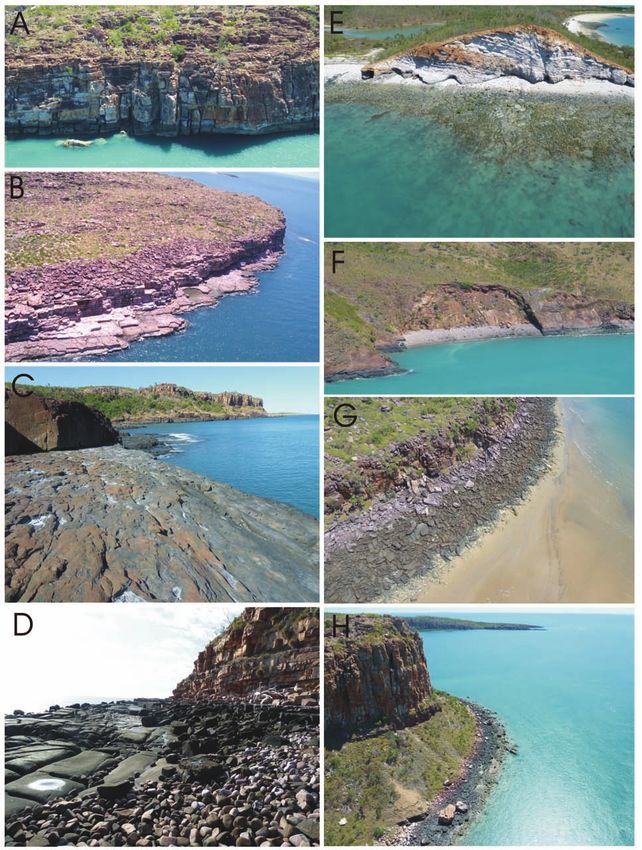
coastal geomorphology. Sandstones form a high relief cross-cutting fractures, geomorphically forms ridge-and-
plateau, with elevation of ~600 m to 300 m, falling to basin topography of WNW-striking linear ridges (the
200 m to 100 m at the coast. They are deeply incised by fold limbs) and associated valleys. Minor, rivers, creeks,
rivers and creeks, with channel margins of steep-sided and their tributaries have followed the dominant grain of
ravines, bluffs, cliffs, and associated mesas. A landscape the geological structure, with smaller tributaries and
of steep-sided ravines, with bluffs and cliffs, and mesas, feeder valleys following the cross-cutting fractures.
with variable sheer rocky surfaces, or scree, or Marine inundation of this topography has resulted in
colluvium presented at the coast, results in steep rocky prominent WNW-striking peninsulae (at various scales),
shores, highly indented coastlines, bouldery shores, and WNW-striking inlets, embayments, and lagoons, WNW-
nearshore or intra-ria islands (usually marine-isolated oriented chains of islands as small local nearshore island
mesas). Three types of coast are developed: 1. those (archipelago) complexes (viz., the Buccaneer
where the bluffs and cliffs are directly presented at the Archipelago), isolated or near-isolated linear high-tidal
shore, thus forming steep rocky shores; 2. those where marine enclosures and, where fracture has influenced
the cliffs, other high-relief landforms, and mesas are set cross-oriented drainage, trellis-shaped embayments and
back from the shore or have been stranded by coastal inlets.
progradation, e.g., Mount Trafalgar in the coastal zone Boundaries between major geological units, major
of the Prince Regent River area; and 3. those comprised faults and fractures, and tectonic grain, and/or a location
of a dissected plateaux and mesas thus forming ria with a geological unit, have been the control for
tracts with intra-ria nearshore islands, i.e., marine- development of some major rivers (compare Figure 7
isolated mesas. The cliff lines of the latter coasts are with Figure 8). Following the post-glacial transgression,
often bordered by tidal sedimentary deposits, or by the seaward expression of the major rivers are large gulfs
aprons of colluvium, or themselves frame ribbons of and inlets. As noted earlier, the Prince Regent River
sedimentary deposits. follows a major NW-trending fault. The Fitzroy, May and
The fluvial courses have been controlled by the faults Meda Rivers have carved valley tracts following the
and fracture patterns and, consequently, the valley tracts geological strike of lower Phanerozoic rocks and, in part,
are straight, to rectangular (orthogonally) and the boundary between Precambrian and Phanerozoic
rhomboidally branching. For instance, the Prince Regent rocks. The drainage basins of the Pentecost, Durack and
River, a large straight river, follows a major fault/ King Rivers, terminating in the funnel-shaped
fracture, and its associated creeks and tributaries exhibit Cambridge Gulf, have been localised in, and controlled
a trellis drainage pattern following the fracture patterns by, the folded and faulted terrane of the Halls Creek
in the sandstone-dominated region. Many of the other Orogen.
69You can also read