STRATEGIC HOUSING DEVELOPMENT PLANNING APPLICATION PLANNING REPORT - Holy ...
←
→
Page content transcription
If your browser does not render page correctly, please read the page content below
HOLY CROSS COLLEGE SHD
                                                                              Planning Report

               STRATEGIC HOUSING DEVELOPMENT
                         PLANNING APPLICATION
                                    PLANNING REPORT
FOR LANDS AT HOLY CROSS COLLEGE, CLONLIFFE ROAD, DUBLIN 3
   AND DRUMCONDRA ROAD LOWER, DRUMCONDRA, DUBLIN 9.

                                                               Client
                        CWTC Multi Family ICAV acting on behalf of its
                                            sub-fund DBTR DR1 Fund

                                                                 Date
                                                            July 2021

                                                                                          1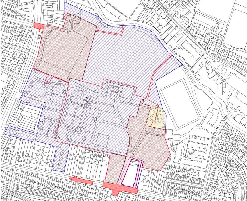
HOLY CROSS COLLEE SHD
Planning Report

     Brady Shipman Martin            www.bradyshipmanmartin.com
     DUBLIN
     Canal House
     Canal Road
     Dublin 6
     + 353 1 208 1900

     CORK
     Penrose Wharf Business Centre
     Penrose Wharf
     Cork
     +353 21 242 5620

     LIMERICK
     11 The Crescent
     Limerick
     +353 61 315 127

 mail@bradyshipmanmartin.com

 2
HOLY CROSS COLLEGE SHD
                                                                                            Planning Report

TABLE OF CONTENTS

1    INTRODUCTION .................................................................................. 4

2    SITE LOCATION AND CONTEXT ........................................................... 9
     2.1     Site Location ...................................................................................... 9
     2.2     Wider Site Ownership Context.......................................................... 9

3    PLANNING HISTORY ......................................................................... 11

4    PRE-PLANNING CONSULTATION ...................................................... 13

5    PLANNING FRAMEWORK ................................................................. 15
     5.1     Dublin City Development Plan 2016-2022...................................... 15

6    SCHEMATIC MASTERPLAN FOR WIDER HOLY CROSS LANDS ........... 21

7    PROPOSED DEVELOPMENT .............................................................. 23
     7.1     Overall Design Rationale ................................................................. 26
     7.2     Proposed Scheme Rational & Justification ..................................... 28
     7.3     Compliance with the Zoning Objective ........................................... 30
     7.4     Quality Housing ............................................................................... 33
     7.5     Residential Development Standards ............................................... 34
     7.6     Height .............................................................................................. 43
     7.7     Residential Amenity & Other uses .................................................. 52
     7.8     Childcare Facility ............................................................................. 52
     7.9     Access, Car & Cycle Parking ............................................................ 53
     7.10 Sunlight and Daylight ...................................................................... 56
     7.11 Wind Microclimate Study ................................................................ 58
     7.12 Community Infrastructure & Childcare and Schools Assessment .. 58

8    PART V – SOCIAL HOUSING .............................................................. 58

9    ENVIRONMENTAL ASSESSMENT ...................................................... 59
     9.1     Birds and Habitats Directive – Appropriate Assessment ................ 59
     9.2     EIA Directive .................................................................................... 60

10   CONCLUSION .................................................................................... 60

                                                                                                                 3
HOLY CROSS COLLEE SHD
Planning Report

1    INTRODUCTION

This Planning Report has been prepared in support of a SHD Application to An
Bord Pleanala, on behalf of CWTC Multi Family ICAV acting on behalf of its sub-
fund DBTR DR1 Fund. The subject application site (hereafter called ‘the site’) is
located at Holy Cross College, Clonliffe Road, Dublin 3 and Drumcondra Road
Lower, Drumcondra, Dublin 9. It is a site of approx. 8.9 hectares, with a site
development area of c. 8 hectares.

The site is bound by Drumcondra Road Lower, Mater Dei College and the
Archbishops House (a Protected Structure) to the West, Clonliffe Road to the
South, Cornmill Apartments and Belvedere College Rugby Grounds to the East
and by the Tolka River to the North.

This application falls under the definition of Strategic Housing Development as
set out under Section 3 of the Planning and Development (Housing) and
Residential Tenancies Act 2016 as it is a proposed development ‘of 100 or more
houses on land zoned for residential use or for a mixture of residential and other
uses’.

The lands are predominately zoned Z12 – ‘Institutional Land (Future
Development Potential)’ which has the stated aim “to ensure existing
environmental amenities are protected in the predominantly residential future
use of these lands”. The use of these lands for residential purposes is provided in
the Core Strategy with regards to the availability of land to deliver residential
development. A small portion of the site, to the north adjacent the Tolka River is
zoned Z9- Amenity/Open Space Lands/Green Network however no residential
development is proposed on these lands.

This Planning Report, in addition to a Statement of Consistency with Planning
Policy, accompanies the Strategic Housing Development Application.

The development for which permission is sought is, as set out in the Statutory
Notices:

The development will consist of:

1. Demolition of a number of existing office/former college buildings on site,
   including the New Wing and Library Wing Buildings, (c. 6,130 sq.m) and the
   construction of a residential development with a gross floor area of c. 119,459
   sq.m (excluding basement parking areas) set out in 12 no. residential blocks,
   ranging in height from 2 to 18 storeys to accommodate 1,614 no. Build to
   Rent apartments with associated residential tenant amenity, 1 no. retail unit,
   1 no. café, and a crèche. The site will accommodate a total of 508 no. car
   parking spaces and 2,507 no. bicycle parking spaces in three separate

 4
HOLY CROSS COLLEGE SHD
Planning Report
basement/podium areas and at surface level. Landscaping will include
extensive new public open spaces and communal courtyards, podiums and
roof terraces.
2. The 12 no. residential buildings range in height from 2 storeys to 18 storeys,
accommodating 1,614 no. Build To Rent apartments comprising 540 studios,
603 no. 1 bed units, 418 no. 2 bed units and 53 no. 3 bed units. The breakdown
of residential accommodation is as follows:
Block A1 is a 4 to 8 storey building, including setbacks, balconies and
terraces, accommodating 305 no. units;
Block A2 is a 7 storey building, including setbacks and balconies,
accommodating 73 no. units;
Block A3 is an 8 storey building, including setbacks and balconies,
accommodating 87 no. units;
Block A4 is a 6 to 13 storey building, including setbacks, balconies and
terraces, accommodating 104 no. units;
Block B1 is a 5 to 6 storey building, including setbacks and balconies,
accommodating 92 no. units;
Block B2 is a 6 to 8 storey building, including setbacks and balconies,
accommodating 137 no. units;
Block B3 is a 5 to 6 storey building, including setbacks and balconies,
accommodating 80 no. units;
Block C1 is a 6 to 8 storey building, including setbacks and balconies,
accommodating 146 no. units;
Block C2 is a 5 to7 storey building, including setbacks and balconies,
accommodating 96 no. units;
Block D1 is an 18 storey building, including setbacks, balconies and
terraces, accommodating 151 no. units;
Block D2 is an 4 to 8 storey building, including setbacks and balconies,
accommodating 239 no. units;
The Seminary Building and South Link Building (E1&E2) are existing
Protected Structures of 2 to 4 storeys with a proposed 5 storey extension
to the rere of the Seminary Building and conversion of both buildings to
accommodate 104 no. residential units including balconies; and
Residential Tenant Amenity Space is provided throughout the existing and
proposed blocks totalling c.3,463 sq.m and Communal External Amenity
Space is provided adjacent each Block and at roof level on Blocks A1, A4,
and D2, totalling c.13,729 sq.m.
3. The site contains a number of Protected Structures including The Seminary
Building, Holy Cross Chapel, South Link Building, The Assembly Hall and The
Ambulatory. The application proposes the renovation and extension of the
Seminary Building to accommodate residential units and the renovation of
the existing Holy Cross Chapel and Assembly Hall buildings for use as
residential tenant amenity. The wider Holy Cross College lands also includes
Protected Structures including The Red House and the Archbishop’s House
(these are not included in the application boundary and no works are
proposed to these Protected Structures with the exception of the proposed
works to the Drumcondra Rd boundary wall which is listed under the
5
HOLY CROSS COLLEE SHD
Planning Report
Protected Structure of the Archbishop’s House as noted below). The works to
the Protected Structures within the application site are set out as follows:
The Seminary Building (RPS Ref 1901): The works consist of the
careful refurbishment and alteration of the existing four storey
Seminary Building to provide residential accommodation, with the
addition of a new five storey residential block to the rere (West
elevation); floor levels carry through on the four lower levels. It is
proposed that the existing structure, the Library Wing, on the
northern elevation of the Seminary and the connecting corridors to
the Seminary will be demolished; new infill concrete walls are located
to fill the gap where elements are removed. Materials that can be
salvaged from these blocks will be surveyed, their location noted, and
re-used in the conservation and restoration works in The Seminary
Building. The projecting WC blocks to the rere (west) elevation of The
Seminary Building are also proposed to be demolished. The external
envelope of The Seminary Building, with existing chimneys, stone and
render finishes, windows and doors is maintained and re-used; the
stone cross from the pediment is removed and built into a wall in the
new residential block which forms an extension to the existing
Seminary Building. Selected window opes on the lateral North and
South elevations are lowered from door opes to provide for balcony
access. The scheme proposes 56 no. apartments installed within the
existing shell on the East side of a corridor running along the rere of
the plan; the 48 no. apartments in the new block are linked to this
corridor through a number of the window opes of the rere elevation
which are lowered to ground level. Lightwells, lifts and staircases are
also accessed in this way.
The South Link Building (RPS Ref 1901): The South Link Building
consists of a two- storey stone and render block with slate roof and
bellcote between Holy Cross Chapel and the The Seminary Building;
this building will be conserved and restored. Alterations to the South
Link Building include the insertion of a new doorway within the
existing front (Eastern) façade to link the front of the building to the
cloister garden, and the insertion of two no apartments in the ground
and first floor space. The existing organ at first floor level will be
moved to a new location within the Holy Cross Chapel.
Holy Cross Chapel (RPS Ref 1901): Holy Cross Chapel is retained and
restored as a tenant amenity space. External alterations include a
new metal door and ramp to the South elevation; interior alterations
are limited to services and decoration; a section of the existing tiled
floor will be lifted to allow for service connections to furniture
installations. The following items will be moved from the Chapel as a
part of the works: Main altar, 2 no. side altars, 2. no paintings to
either side of chancel arch, Stations of the Cross, 2 no. marble statues
to narthex, Loose pews, Confessional, Fixed furniture to sacristy.
Method statements for these works are included in the application
documents.
6
HOLY CROSS COLLEGE SHD
Planning Report
The Assembly Hall (RPS Ref 1901): The Assembly Hall comprises a
two- storey hall with its front façade, steps and projecting porch
orientated towards Clonliffe Road. The building is conserved and
restored as a tenant amenity space as a part of the proposal; the
existing balcony level within the main space is removed. The existing
stage area is also removed to provide a gym area; bicycle storage is
provided within the envelope to the North-West. Existing doors and
windows are retained and repaired. A new window is provided into
the cloister, with smaller secondary opes cut between spaces.
The Ambulatory (RPS Ref 1901): All of the above referenced buildings
are linked by a cloister colonnade (i.e. the Ambulatory) around two
sides of a central garden; there is a part section of the colonnade on
the North side and an indented (enclosed) section directly outside
Holy Cross Chapel; the fourth (east) side is completed by the rere
elevation of The Seminary Building. The Ambulatory will be retained
as part of the proposed development. The cloister garden will be
restored and conserved as a part of the project for circulation and
amenity use. Mosaic panels to the cloister will be retained and
covered to supply a base for a removable light fitting. The courtyard
garden will be re-designed and re-planted as a part of the scheme.
Drumcondra Rd Boundary Wall Entrance (Listed under Archbishop’s
House RPS 2361): The existing entrance gates and the adjoining walls
are part of the Archbishop’s House Protected Structure. It is proposed
to take down the existing stone gate pier to the south, and
reconstruct this pier in a new location further to the south, widening
the gate opening in this location. This will involve the taking down of
a small portion of the stone boundary wall.
4. Extensive areas of public open space of c.20,410 sq.m or 25% of the site is
provided for, including woodland walk, formal lawn seminary garden, dog
park and, playground. The proposed landscaping scheme provides for the
removal of some existing trees on the site as well as extensive new planting.
5. Non-residential uses include a crèche of c. 627 sq.m and 1 no. retail unit of c.
329 sq.m in Block A4, and 1 no. café unit of c.273 sq.m in Block D1. Total gross
floor area of proposed other uses is 1,229 sq.m.
6. The development will include a single level basement under Blocks B2, B3 &
C1, containing 158 car spaces, 582 cycle parking spaces, plant, storage areas,
waste storage areas and other associated facilities, a single level basement
under Block D2 containing 86 car spaces, 528 cycle parking spaces, plant,
storage areas, waste storage areas and other associated facilities and a part
podium level basement, part single level basement under Block A1, containing
233 car spaces, 500 cycle parking spaces, plant, storage areas, waste storage
areas and other associated facilities. The remainder of residents bicycle
stores, totalling 645 spaces, are located proximate to residential buildings. In
addition 31 no. parking spaces are located at surface level to include visitor,
accessible, EV, car club and loading spaces as well as 252 no. short stay
bicycle parking spaces.
7
HOLY CROSS COLLEE SHD
Planning Report

7. The site is accessed by vehicles, cyclists and pedestrians from a widened
   existing entrance on Clonliffe Road, at the junction with Jones’s Road, and
   through the opening up of an existing access point on Drumcondra Road
   Lower at the junction with Hollybank Road to act as a left in/left out access.
   No through route for vehicular access through the site for the public is
   proposed. An additional cyclist and pedestrian access is proposed through an
   existing access point on Holy Cross Avenue. Access from the Clonliffe Road
   entrance will also facilitate vehicular access to future proposed GAA pitches
   and clubhouse to the north of the site and to a permitted hotel on Clonliffe
   Road (DCC Reg. Ref.: 2935/20, ABP Reg. Ref.: PL29N.30819).

8. The proposed application includes all site landscaping works, green roofs,
   boundary treatments, lighting, servicing, signage, ESB Substations, PV panels
   at roof level on all residential blocks except E1/E2 and D2, and associated and
   ancillary works, including site development works above and below ground.

This report examines the site location, context, and planning history. It also has
regard to issues of compliance with the Dublin City Development Plan 2016-2022,
and Section 28 Guidelines, which are the relevant statutory documents against
which the development will be considered.

This SHD planning application is accompanied by a comprehensive set of
documentation which specifically seeks to address the requirements of the
Planning and Development (Housing) and Residential Tenancies Act 2016, the
Planning and Development (Strategic Housing Development) Regulations 2017
and the requirements of the Dublin City Development Plan 2016-2022.

An Environmental Impact Assessment Report (EIAR), which also constitutes an
Environmental Impact Statement (EIS) as required under the Planning and
Development Regulations, 2001 (as amended), is submitted to An Bord Pleanala
with the planning application.

An Information for Appropriate Assessment Screening is submitted to An Bord
Pleanala with the planning application prepared by Brady Shipman Martin that
accompanies this application which concludes that no likely significant impacts
on Natura 2000 sites are predicted.

This Planning Report should be read in conjunction with the other documentation
(reports and drawings) accompanying this SHD planning application, set out in
the schedule included in the Cover Letter to An Bord Pleanala.

We confirm that prior to making this planning application the drawings enclosed
herewith have been checked with reference to the Planning and Development
Regulations, 2001-2021.

 8
HOLY CROSS COLLEGE SHD
                                                                   Planning Report
2     SITE LOCATION AND CONTEXT

2.1    Site Location

The full Masterplan lands is c.12 hectares and the application site is
approximately 8.9 ha in size and located 1.7 km north of Dublin City Centre. The
site is bounded by Drumcondra Road Lower, Mater Dei College and the
Archbishops House (a Protected Structure) to the West, Clonliffe Road to the
South, Cornmill Apartments and Belvedere College Rugby Grounds to the East
and by former playing pitches and the Tolka River to the North.

The surrounding area is comprises a mix of uses, including: light industrial and
warehousing to the north; residential areas to the south, west and east at along
Clonliffe Road and Drumcondra Road; and, the sports facilities directly east and
to the north beyond the River Tolka is Tolka Park Football Stadium.

The site comprises a number of greenspaces and existing large institutional
buildings (approx. 11,865sqm) associated with its current use (some of which are
protected structures). The site as many large mature trees giving it a unique
character apart from the nearby busy roads.

The northern portion of the site is set back from the busy Drumcondra road,
separated by large mature trees. While the southern part of the site fronts onto
Clonliffe Road.

The site sits between the established residential communities of Drumcondra to
the west and north and Clonliffe Road and Ballybough to the South and East. Both
are established, mature suburbs of Dublin City with the surrounding area
predominately developed. The immediate area gives access to a range of public
facilities including community centres, healthcare, libraries, shops and sports /
recreation facilities.

The site is approximately 400m from Drumcondra Commuter Railway Station to
the south west, and adjacent to Drumcondra Road, which is a quality bus corridor
(QBC) that is served by several Dublin Buses including: No’s 13; 16; 41; 41c; 1; 11;
33; and 44. It is anticipated that the site will be served by Bus Connects ‘Core Bus
Corridor No. 2’ (Swords to City Centre).

2.2    Wider Site Ownership Context

The Holy Cross College Lands were acquired by the Archdiocese in 1859, college
facilities were developed and they housed a seminary for the Catholic Church in
Ireland and administration offices for the Archdiocese and various diocesan
activities. The seminary ceased operation in year 2000 but the buildings still
accommodate administration offices for the Archdiocese, the various diocesan

                                                                                 9
HOLY CROSS COLLEE SHD Planning Report activities and offices for some charitable organisations (Crosscare and DePaul). These activities are vacating the properties. The Archdiocese has since entered into an agreement with Cumann Lúthchleas Gael / the Gaelic Athletic Association to acquire these lands and who have subsequently entered into an agreement to onward sell these to Hines Real Estate Ireland (through the applicant CWTC Multi Family ICAV acting on behalf of its sub-fund DBTR DR1 Fund). The Archdiocese will retain the Archbishop’s Residence and surrounding lands and lands in the south-west corner of the Holy Cross College property, which includes the Mater Dei building, a Family Hub, and a large surface car park These lands are included in the Masterplan, The Red House (Dublin City Council Registered Protected Structure Reference Number 1902 and Recorded Monument Ref. No. 018-019) and curtilage is owned by Páirc an Chrócaigh Teoranta Cuideachta Faoi Theorainn Ráthaíochta / Cumann Lúthchleas Gael (Gaelic Athletic Association (GAA)) as well as the land at the south eastern corner of the Holy Cross College lands which has been subject to an approval by An Bord Pleanála for a 2 to 7 storey 200 room hotel. The land parcel to the north of the Holy Cross College lands, former grass playing pitches, are operated by the GAA and are due to be formally acquired by the GAA from the Archdiocese of Dublin. The GAA plans to build two playing pitches on this land parcel, with a club house and carpark. The proposed A and B Blocks and plots, associated road and pathways networks and supporting infrastructure have been carefully designed and laid out to facilitate the development of the proposed playing pitches and associated facilities, subject to a separate planning application by the GAA in due course. The development proposed also allows for the potential future vehicular access to the playing pitches from the Drumconda Road Lower access point, in order to facilitate the potential for the GAA to accommodate car parking on the playing pitches on occasion during key match day events. Entry would be provided from the proposed housing development’s access point in the north west corner of the lands, off Drumcondra Road Lower. Cars would enter via the Drumcondra Road Lower access and exit on the Clonliffe Road access point. Planning permission for the parking of vehicles on this part of the site is not included for nor sought under this planning application – and is a matter for the GAA to pursue in due course. The GAA has been consulted in relation to the proposed housing development’s water supply and drainage infrastructure to ensure that the infrastructure does not prejudice future development potential of the GAA lands. The same applies to electricity infrastructure on the site, which has been carefully considered with 10
HOLY CROSS COLLEGE SHD
                                                                      Planning Report
the GAA to ensure that the infrastructure will facilitate the GAA developments at
a later date.

As noted above the Red House and its curtilage are owned by the GAA and does
not form part of the proposed housing development, other in respect of
proposed adjacent landscaping. Its setting and curtilage need to be preserved in
line with its protected structure status. The Red House was the original Holy
Cross College before it was relocated to the Seminary Building. The historic
affiliation between these buildings means a visual connection needs to be
preserved. The proposed housing development, and orientation of the adjoining
B and D Blocks and plots, retains this visual connection of these buildings and
enhances both the Seminary and front central lawn in this location. The
proposed development will retain the existing circulation route on the site that
includes the entrance to the Red House. Views to this protected structure and
its architectural heritage will therefore be maintained.

The proposed 2 to 7 storey 200 room hotel, and associated facilities, services and
works, on the GAA owned land in the south eastern corner of the Holy Cross
College lands recently received planning permission, from An Bord Pleanála. The
proposed housing development site includes a strip of land towards the eastern
boundary of the proposed hotel lands. There is a watermain proposed along this
boundary that will connect to the trunk watermain which runs along Clonliffe
Road. Connections to both the proposed hotel and the housing development will
be provided from this watermain connection. There are also electrical and
telecommunication cabling proposed to run along this boundary for the
proposed housing development that the hotel could connect to.

3    PLANNING HISTORY

The application site and the wider masterplan site, have been subject to a
number of planning applications in recent years which primarily relate to the
normal function and operation of its institutional uses.

We note the following applications associated with the subject site which relate
to the existing institutional use of the lands:

 Reg. Ref.       Description                                          Decision
                 PROTECTED STRUCTURE: The subject site
                 encompasses an area of 0.51 hectares. The
 2935/20                                                              Granted by ABP
                 development will consist of: the construction of a
 ABP Ref:                                                             on 8th April
                 part -2 to part -7 storey 8,485 sq.m. hotel
 PL29N.308193                                                         2021
                 building comprising 200 - bedrooms arranged
                 over floors 1-6.

                                                                                 11
HOLY CROSS COLLEE SHD
Planning Report
PROTECTED STRUCTURE: Permission sought for
the demolition of one disused single storey
2361/16 bungalow, 81 sq. metres, at this site located at Granted
Clonliffe Road, Dublin 3. The bungalow is within 14-Apr-2016
the curtilage of Clonliffe College, a Protected
Structure.
PROTECTED STRUCTURE - Planning permission
for external safety & health works within the
curtilage of ''The Assembly Hall'' (a protected
structure), comprising:- (1) Removal of existing
external lecture theatre escape stairs and
replacement with new stairs, walkway, handrails
Granted
2607/11 & guarding (2) Removal & replacement of
17-Jun-2011
balustrading/guarding to existing external rear
stairs and area. (3) Construction of new rear
pedestrian emergency exit gate and replacement
of existing rear vehicular delivery gates. (4)
Addition of 3no. handrails to front external
approach steps.
PROTECTED STRUCTURE - Change of use of the
ground floor of the northerly wing (377sqm) of
3032/10 Granted
the Diocesan Offices building from educational
06-Aug-2010
use to office use. The building is located within
the curtilage of protected structures.
PROTECTED STRUCTURE- Planning permission for
external health and safety works within the
curtilage of 'The Assembly Hall' (a protected
structure), comprising:- (1) Removal and
replacement of existing external Lecture Theatre Granted
2947/10
escape stairs, handrails and guarding. (2) 28-Jul-2010
Removal and replacement of
balustrading/guarding to existing external rear
stairs and area. (3) Addition of 3no. handrails to
front external approach steps.
Application by the Board of Management of
Mater Dei Institute Of Education for planning
permission for addition of a new mezzanine floor
within The Assembly Hall; (a protected
structure), for formation of 3 no. study rooms, Granted
1652/06
for 2 no. new stairs, and for associated fire 12-Apr-2006
safety, partitioning, and other works - all at
204/206, Clonliffe Road, Dublin 3. These works
do not involve any alterations to the exterior of
the building.
12HOLY CROSS COLLEGE SHD
Planning Report
4 PRE-PLANNING CONSULTATION
Both the context and approach to the application site and the design rationale
for the proposed development, have been subject to considerable consultation
with the Dublin City Council Planning Department under Section 247.
A series of meetings have been held with the City Council’s Planning Department
as formal pre-application discussions on the substance of the proposed
development, on the following dates:
4th February 2020- Mary Conway (Deputy City Planner)- Joint Meeting
with representative of the GAA and the Archdiocese
5th May 2020- Mary Conway (Deputy City Planner), Mary McDonald
(Senior Executive Architectural Conservation Officer-Acting)
22nd May 2020- Mary Conway (Deputy City Planner), Deirdre O’Reilly
(Senior Planner)
16th June 2020- Mary Conway (Deputy City Planner), Deirdre O’Reilly
(Senior Planner), Mary McDonald (Senior Executive Architectural
Conservation Officer-Acting)
29th June 2020- Mary Conway (Deputy City Planner), Mary McDonald
(Senior Executive Architectural Conservation Officer-Acting)
9th July 2020- Mary Conway (Deputy City Planner), Deirdre O’Reilly
(Senior Planner)
14th July 2020- Mary Conway (Deputy City Planner), Mary McDonald
(Senior Executive Architectural Conservation Officer-Acting)
22nd July 2020- Mary Conway (Deputy City Planner), Deirdre O’Reilly
(Senior Planner), Mary McDonald (Senior Executive Architectural
Conservation Officer-Acting)
4th August 2020- Mary Conway (Deputy City Planner), Mary McDonald
(Senior Executive Architectural Conservation Officer-Acting)
18th August 2020- Mary Conway (Deputy City Planner), Mary McDonald
(Senior Executive Architectural Conservation Officer-Acting)
31st August 2020- Mary Conway (Deputy City Planner), Deirdre O’Reilly
(Senior Planner)
1st September 2020- Mary Conway (Deputy City Planner), Mary
McDonald (Executive Architectural Conservation Officer)
7th October 2020- Mary Conway (Deputy City Planner), Kieran O’Neill
(Senior Executive Landscape Architect)
13th October 2020- Mary Conway (Deputy City Planner), Deirdre O’Reilly
(Senior Planner), Mary McDonald (Senior Executive Architectural
Conservation Officer-Acting)
22nd October 2020- Mary Conway (Deputy City Planner), Deirdre O’Reilly
(Senior Planner)
13HOLY CROSS COLLEE SHD
Planning Report
9th March 2021- Mary Conway (Deputy City Planner), Garrett Hughes
(Senior Planner), Audrey Taylor (Executive Planner), Mary McDonald
(Senior Executive Architectural Conservation Officer-Acting)
Discussions on the proposed development have also taken place with the
Council’s Conservation Department, Traffic & Transportation Department and
the Parks Department.
In addition Tri Partite Meeting took place with An Bord Pleanala and Dublin City
Council on 18th January 2021.
14HOLY CROSS COLLEGE SHD
Planning Report
5 PLANNING FRAMEWORK
The planning policy and context for the proposed scheme is established in
national and local policy. These are considered in the Statement of Consistency
with this section of the Planning Report outlining the key elements of the specific
local planning policy established in the Dublin City Development Plan 2016-2022.
5.1 Dublin City Development Plan 2016-2022
The subject site is located within the administrative area of Dublin City Council.
The Dublin City The Dublin City Development Plan 2016-2022 sets the statutory
planning policy for development within the City Boundary, having regard to
national and regional plans and policies. The Development Plan provides the
planning policy framework and design and development standards for
development of the subject lands.
The proposed development supports the achievement of DCC Development Plan
objectives in a number of key areas which are discussed below. Further,
compliance with County, Regional and National policy are detailed within the
enclosed Statement of Consistency prepared by BSM which should be read in
conjunction to this Planning Report.
5.1.1 Core Strategy
The Development Plan sets out its overall ‘Vision for the Dublin’ City which is to
create a more sustainable and resilient city. Within this vision the Development
Plan aims to improve quality of life for all.
Section 1.2 outlines how to achieve this and the following is of relevance:
b) Social/Residential – Developing Dublin as a compact city with a network of
sustainable neighbourhoods which have a range of facilities and a choice of
tenure and house types, promoting social inclusion and integration of all ethnic
communities.
The Core Strategy sets out ‘Population and Housing Figures Based on Census Data
2011, Estimate for 2013’, and Regional Planning Guidelines allocations (now
superseded by the RSES).
Table A of the Core Strategy identifies a need for approximately 29,500 new
residential units over the life of the Plan. Table C quantifies the area of lands
zoned for residential development (4,466ha) or for a mix of uses including
residential (2,043ha).
15HOLY CROSS COLLEE SHD
Planning Report
Table C of the Core Strategy includes Z12 lands. In this regard the subject Z12
zoned lands are included in Core Strategy calculations for achieving sufficient
zoned lands to cater for targeted population growth. The development of the
lands for residential purposes supports the achievement of Core Strategy targets.
The subject area is located in the North Central housing strategy area. The Core
Strategy in the Dublin City Development Plan 2016 – 2022 (DCDP) indicates the
subject lands zoned have strategic capacity in terms of housing provision for the
North Central Area. The lands have been included in the residential core strategy
as ‘available suitable land for housing development’.
Figure 5.1: Development Plan Core Strategy Map (Source: DCC,2020).
The Development Plan states the long-term vision and the core strategy can be
translated into ‘three strongly interwoven strands’ which are as follows:
1. Compact, Quality, Green, Connected City
2. A Prosperous, Enterprising, Creative City
3. Creating Sustainable Neighbourhoods and Communities
Overall the proposed development has had careful regard to the policies and
objectives contained within the Development Plan. In particular the proposed
development supports the achievement of Objective SC13:
SC13: To promote sustainable densities, particularly in public transport
corridors, which will enhance the urban form and spatial structure of the
city, which are appropriate to their context, and which are supported by
a full range of community infrastructure such as schools, shops and
recreational areas, having regard to the safeguarding criteria set out in
16HOLY CROSS COLLEGE SHD
Planning Report
Chapter 16 (development standards), including the criteria and standards
for good neighbourhoods, quality urban design and excellence in
architecture. These sustainable densities will include due consideration
for the protection of surrounding residents, households and communities.
The design, layout and open space will result in a high quality community and
residential environment. Communal facilities have been included within the
proposed development to serve future residents.
In summary, the proposed development supports the achievement of the above
vision by providing high quality residential development in proximity to public
transport corridors. This development will foster a new community through its
landscaped and open space strategy; mix of unit types and sizes; and provision of
residential facilities; and, high quality architectural design.
Residential Development
Similarly Chapter 5 of the Development Plan relates to Quality Housing
Objectives. In particular the QH6 & QH7 aim to:
QH6: To encourage and foster the creation of attractive mixed-use
sustainable neighbourhoods which contain a variety of housing types and
tenures with supporting community facilities, public realm and residential
amenities, and which are socially mixed in order to achieve a socially
inclusive city.
QH7: To promote residential development at sustainable urban densities
throughout the city in accordance with the core strategy, having regard
to the need for high standards of urban design and architecture and to
successfully integrate with the character of the surrounding area
The Development Plan further notes that, in Dublin City, it is envisaged that the
majority of new housing in the city area will be apartments or another typology
that facilitates living at sustainable urban densities.
With regards to apartments, the DCC policies are as follows:
QH18: To promote the provision of high quality apartments within
sustainable neighbourhoods by achieving suitable levels of amenity
within individual apartments, and within each apartment development,
and ensuring that suitable social infrastructure and other support
facilities are available in the neighbourhood, in accordance with the
standards for residential accommodation.
QH19: To promote the optimum quality and supply of apartments for a
range of needs and aspirations, including households with children, in
17HOLY CROSS COLLEE SHD
Planning Report
attractive, sustainable, mixed-income, mixed-use neighbourhoods
supported by appropriate social and other infrastructure.
QH20: To ensure apartment developments on City Council sites are
models of international best practice and deliver the highest quality
energy efficient apartments with all the necessary infrastructure where a
need is identified, to include community hubs, sports and recreational
green open spaces and public parks and suitable shops contributing to
the creation of attractive, sustainable, mixed-use and mixed-income
neighbourhoods.
SN1: To promote good urban neighbourhoods throughout the city which
are well designed, safe and suitable for a variety of age groups and
tenures, which are robust, adaptable, well served by local facilities and
public transport, and which contribute to the structure and identity of the
city, consistent with standards set out in this plan.
The scheme as proposed introduces a mix of residential unit types and sizes to
an existing and established residential neighbourhood of the City. A Housing
Needs Assessment and Unit Mix Analysis as well as a Social & Community
Infrastructure Audit has been prepared to demonstrate how the proposed
scheme integrates to the existing residential profile of the area and existing social
and community infrastructure.
5.1.2 Land Use Zoning
The subject site is predominantly zoned Z12 ‘Institutional Land (Future
Development Potential)’, along with the adjacent sports pitches, which has the
stated aim “to ensure existing environmental amenities are protected in the
predominantly residential future use of these lands”.
The area immediately adjacent to the River Tolka, abutting and partly within the
site, is zoned Z9 “recreational amenity / open space / green networks”, and the
most north-westerly corner of the site is zoned Z1 Residential. The River Tolka
corridor is a ‘Conservation Area’ with objectives to deliver a linear park along it.
No residential development is proposed within the Z9 zoning in compliance with
the requirements of Strategic Housing Development Applications.
18HOLY CROSS COLLEGE SHD
Planning Report
Figure 5.2: extract from DCC Zoning Map E (Indicative Red Line) (Source: DCC)
Permissible uses and open for consideration uses on Z12 lands include:
Permissible Bed and breakfast, buildings for the health, safety and welfare
Uses of the public; caravan park/camp site (holiday), childcare
facility, community facility, conference centre,
cultural/recreational building and uses, education, embassy
residential, enterprise centre, garden centre, golf course and
clubhouse, guest house, halting site, home-based economic
activity, hostel, hotel, live-work units, media associated uses,
medical and related consultants, open space, place of public
worship, public service installation, residential institution,
residential, restaurant, science and technology-based
industry, shop (local), training centre.
Open for Boarding kennel, car park, civic and amenity/ recycling centre,
Consideration funeral home, industry (light), municipal golf course,
Uses nightclub, office, outdoor poster advertising, part off-licence,
public house, shop (neighbourhood).
The Development Plan identifies specific considerations for the development of
Z12 lands which makes reference to a masterplan as follows:
‘In considering any proposal for development on lands subject to zoning objective
Z12, other than development directly related to the existing community and
institutional uses, Dublin City Council will require the preparation and submission
19HOLY CROSS COLLEE SHD
Planning Report
of a masterplan setting out a clear vision for the future for the development of the
entire land holding.
In particular, the masterplan will need to identify the strategy for the provision of
the 20% public open space requirements associated with any residential
development, to ensure a co-ordinated approach to the creation of high-quality
new public open space on new lands linked to the green network and/or other
lands, where possible.’
The Development Plan identifies a number of specific requirements arising from
the Z12 zoning objective. These include:
• a minimum of 20% of the site, incorporating landscape features and the
essential open character of the site, to be retained as accessible public open
space;
• the preparation and submission of a masterplan setting out a clear vision for
the future for the development of the entire land holding. In particular, the
masterplan will need to identify the strategy for the provision of the 20%
public open space requirements associated with any residential development
to ensure a co-ordinated approach to the creation of high-quality new public
open space on new lands linked to the green network and/or other lands,
where possible;
• the minimum 20% public open space shall not be split up into sections and
shall be comprised of soft landscape suitable for relaxation and children’s
play, unless the incorporation of existing significant landscape features and
the particular recreational or nature conservation requirements of the site
and area dictate that the 20% minimum public open space shall be
apportioned otherwise;
• development at the perimeter of the Z12 sites adjacent to existing residential
development shall have regard to the prevailing height of existing residential
development and to standards in Chapter 16, Section 16.10 of the
Development Plan pertaining to aspect, natural lighting, sunlight, layout and
private open space;
• the 10% social housing requirement shall apply.
In response to the above considerations a Schematic Masterplan has been
prepared by HJL included with this application, and addresses the provisions of
the Z12 Zoning Objective and which are outlined in detail in Section 7.3 below.
20HOLY CROSS COLLEGE SHD
Planning Report
6 SCHEMATIC MASTERPLAN FOR WIDER HOLY CROSS LANDS
A Schematic Masterplan, which has been prepared on behalf of Hines and the
GAA, has been prepared relating respect all of the Clonliffe Lands that are subject
to the Z12 zoning. The Schematic Masterplan describes the future strategic vision
and structure for the redevelopment of lands. The Development Plan requires a
single Masterplan vision for the use of the lands within the area subject to the
zoning, irrespective of the current ownership structure.
The Schematic Masterplan represents the intentions of the main institutional
stakeholder of the lands, working in co-operation with the other landowners
within the subject Z12 area and with Dublin City Council to deliver a vision for the
integrated and sustainable development of the lands, while retaining the main
institutional use in an enhanced condition and setting.
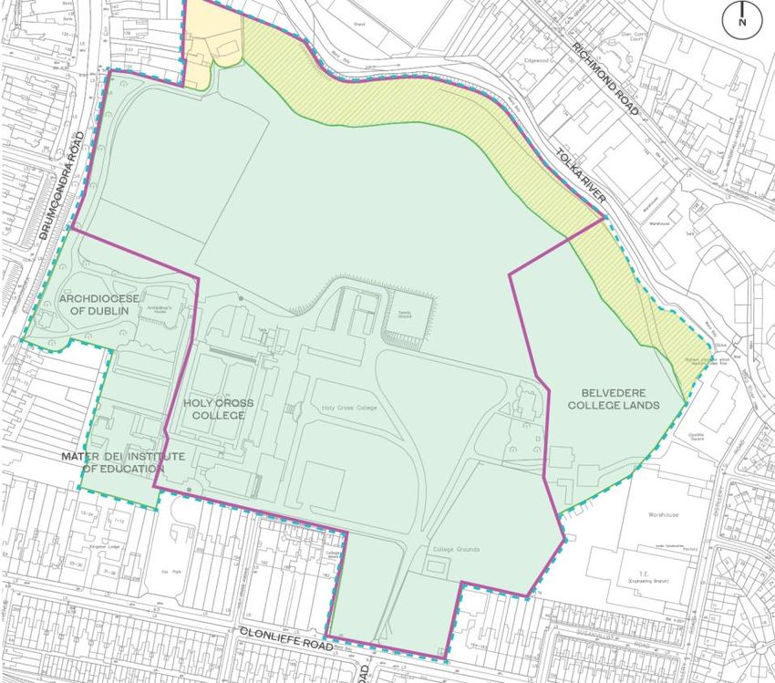
The Schematic Masterplan lands include lands which are currently or in the future
will be in the control of Hines, the GAA and the Archdiocese in addition lands in
the ownership of Belvedere College are identified as they form part of the Z12
Zoning but are not subject to change in the Masterplan.
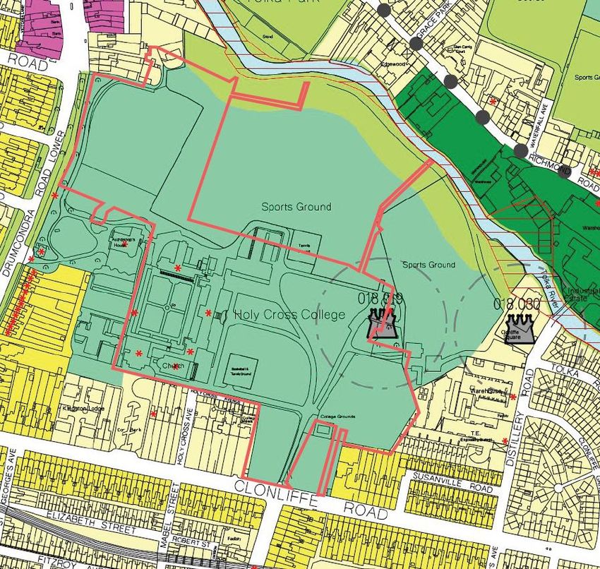
Figure 6.1: Schematic Masterplan Lands in the context of DCC Zonings
21HOLY CROSS COLLEE SHD
Planning Report
Figure 6.2: Schematic Masterplan Lands & Site Interest
To the north of the site is a small portion of Z1 Zoned lands and a strip of Z9 Zoned
land which forms the buffer between the site and the Tolka River- these lands are
considered in the context of the Masterplan as they provide important additional
public open space and access to the river.
The Schematic Masterplan Document has accompanied the application for the
Hotel on the south east corner of the site, as the first application submitted under
the Masterplan. This Application now seeks to bring forth the substantive
elements of the Masterplan in the form of a significant new residential
development and associated public open space.
The Schematic Masterplan has been considered comprehensively in the
proposed approach as set out in this Strategic Housing Development Application
and is detailed in this report, and in the Schematic Masterplan Report and Site
Strategy Report prepared by HJL.
22HOLY CROSS COLLEGE SHD
Planning Report
7 PROPOSED DEVELOPMENT
This proposed development for the site consists of:
The development will consist of:
1. Demolition of a number of existing office/former college buildings on site,
including the New Wing and Library Wing Buildings, (c. 6,130 sq.m) and the
construction of a residential development with a gross floor area of c. 119,459
sq.m (excluding basement parking areas) set out in 12 no. residential blocks,
ranging in height from 2 to 18 storeys to accommodate 1,614 no. Build to
Rent apartments with associated residential tenant amenity, 1 no. retail unit,
1 no. café, and a crèche. The site will accommodate a total of 508 no. car
parking spaces and 2,507 no. bicycle parking spaces in three separate
basement/podium areas and at surface level. Landscaping will include
extensive new public open spaces and communal courtyards, podiums and
roof terraces.
2. The 12 no. residential buildings range in height from 2 storeys to 18 storeys,
accommodating 1,614 no. Build To Rent apartments comprising 540 studios,
603 no. 1 bed units, 418 no. 2 bed units and 53 no. 3 bed units. The breakdown
of residential accommodation is as follows:
Block A1 is a 4 to 8 storey building, including setbacks, balconies and
terraces, accommodating 305 no. units;
Block A2 is a 7 storey building, including setbacks and balconies,
accommodating 73 no. units;
Block A3 is an 8 storey building, including setbacks and balconies,
accommodating 87 no. units;
Block A4 is a 6 to 13 storey building, including setbacks, balconies and
terraces, accommodating 104 no. units;
Block B1 is a 5 to 6 storey building, including setbacks and balconies,
accommodating 92 no. units;
Block B2 is a 6 to 8 storey building, including setbacks and balconies,
accommodating 137 no. units;
Block B3 is a 5 to 6 storey building, including setbacks and balconies,
accommodating 80 no. units;
Block C1 is a 6 to 8 storey building, including setbacks and balconies,
accommodating 146 no. units;
Block C2 is a 5 to7 storey building, including setbacks and balconies,
accommodating 96 no. units;
Block D1 is an 18 storey building, including setbacks, balconies and
terraces, accommodating 151 no. units;
Block D2 is an 4 to 8 storey building, including setbacks and balconies,
accommodating 239 no. units;
The Seminary Building and South Link Building (E1&E2) are existing
Protected Structures of 2 to 4 storeys with a proposed 5 storey extension
to the rere of the Seminary Building and conversion of both buildings to
accommodate 104 no. residential units including balconies; and
23HOLY CROSS COLLEE SHD
Planning Report
Residential Tenant Amenity Space is provided throughout the existing and
proposed blocks totalling c.3,463 sq.m and Communal External Amenity
Space is provided adjacent each Block and at roof level on Blocks A1, A4,
and D2, totalling c.13,729 sq.m.
3. The site contains a number of Protected Structures including The Seminary
Building, Holy Cross Chapel, South Link Building, The Assembly Hall and The
Ambulatory. The application proposes the renovation and extension of the
Seminary Building to accommodate residential units and the renovation of
the existing Holy Cross Chapel and Assembly Hall buildings for use as
residential tenant amenity. The wider Holy Cross College lands also includes
Protected Structures including The Red House and the Archbishop’s House
(these are not included in the application boundary and no works are
proposed to these Protected Structures with the exception of the proposed
works to the Drumcondra Rd boundary wall which is listed under the
Protected Structure of the Archbishop’s House as noted below). The works to
the Protected Structures within the application site are set out as follows:
The Seminary Building (RPS Ref 1901): The works consist of the
careful refurbishment and alteration of the existing four storey
Seminary Building to provide residential accommodation, with the
addition of a new five storey residential block to the rere (West
elevation); floor levels carry through on the four lower levels. It is
proposed that the existing structure, the Library Wing, on the
northern elevation of the Seminary and the connecting corridors to
the Seminary will be demolished; new infill concrete walls are located
to fill the gap where elements are removed. Materials that can be
salvaged from these blocks will be surveyed, their location noted, and
re-used in the conservation and restoration works in The Seminary
Building. The projecting WC blocks to the rere (west) elevation of The
Seminary Building are also proposed to be demolished. The external
envelope of The Seminary Building, with existing chimneys, stone and
render finishes, windows and doors is maintained and re-used; the
stone cross from the pediment is removed and built into a wall in the
new residential block which forms an extension to the existing
Seminary Building. Selected window opes on the lateral North and
South elevations are lowered from door opes to provide for balcony
access. The scheme proposes 56 no. apartments installed within the
existing shell on the East side of a corridor running along the rere of
the plan; the 48 no. apartments in the new block are linked to this
corridor through a number of the window opes of the rere elevation
which are lowered to ground level. Lightwells, lifts and staircases are
also accessed in this way.
The South Link Building (RPS Ref 1901): The South Link Building
consists of a two- storey stone and render block with slate roof and
bellcote between Holy Cross Chapel and the The Seminary Building;
this building will be conserved and restored. Alterations to the South
Link Building include the insertion of a new doorway within the
existing front (Eastern) façade to link the front of the building to the
cloister garden, and the insertion of two no apartments in the ground
24HOLY CROSS COLLEGE SHD
Planning Report
and first floor space. The existing organ at first floor level will be
moved to a new location within the Holy Cross Chapel.
Holy Cross Chapel (RPS Ref 1901): Holy Cross Chapel is retained and
restored as a tenant amenity space. External alterations include a
new metal door and ramp to the South elevation; interior alterations
are limited to services and decoration; a section of the existing tiled
floor will be lifted to allow for service connections to furniture
installations. The following items will be moved from the Chapel as a
part of the works: Main altar, 2 no. side altars, 2. no paintings to
either side of chancel arch, Stations of the Cross, 2 no. marble statues
to narthex, Loose pews, Confessional, Fixed furniture to sacristy.
Method statements for these works are included in the application
documents.
The Assembly Hall (RPS Ref 1901): The Assembly Hall comprises a
two- storey hall with its front façade, steps and projecting porch
orientated towards Clonliffe Road. The building is conserved and
restored as a tenant amenity space as a part of the proposal; the
existing balcony level within the main space is removed. The existing
stage area is also removed to provide a gym area; bicycle storage is
provided within the envelope to the North-West. Existing doors and
windows are retained and repaired. A new window is provided into
the cloister, with smaller secondary opes cut between spaces.
The Ambulatory (RPS Ref 1901): All of the above referenced buildings
are linked by a cloister colonnade (i.e. the Ambulatory) around two
sides of a central garden; there is a part section of the colonnade on
the North side and an indented (enclosed) section directly outside
Holy Cross Chapel; the fourth (east) side is completed by the rere
elevation of The Seminary Building. The Ambulatory will be retained
as part of the proposed development. The cloister garden will be
restored and conserved as a part of the project for circulation and
amenity use. Mosaic panels to the cloister will be retained and
covered to supply a base for a removable light fitting. The courtyard
garden will be re-designed and re-planted as a part of the scheme.
Drumcondra Rd Boundary Wall Entrance (Listed under Archbishop’s
House RPS 2361): The existing entrance gates and the adjoining walls
are part of the Archbishop’s House Protected Structure. It is proposed
to take down the existing stone gate pier to the south, and
reconstruct this pier in a new location further to the south, widening
the gate opening in this location. This will involve the taking down of
a small portion of the stone boundary wall.
4. Extensive areas of public open space of c.20,410 sq.m or 25% of the site is
provided for, including woodland walk, formal lawn seminary garden, dog
park and, playground. The proposed landscaping scheme provides for the
removal of some existing trees on the site as well as extensive new planting.
25HOLY CROSS COLLEE SHD
Planning Report
5. Non-residential uses include a crèche of c. 627 sq.m and 1 no. retail unit of c.
329 sq.m in Block A4, and 1 no. café unit of c.273 sq.m in Block D1. Total gross
floor area of proposed other uses is 1,229 sq.m.
6. The development will include a single level basement under Blocks B2, B3 &
C1, containing 158 car spaces, 582 cycle parking spaces, plant, storage areas,
waste storage areas and other associated facilities, a single level basement
under Block D2 containing 86 car spaces, 528 cycle parking spaces, plant,
storage areas, waste storage areas and other associated facilities and a part
podium level basement, part single level basement under Block A1, containing
233 car spaces, 500 cycle parking spaces, plant, storage areas, waste storage
areas and other associated facilities. The remainder of residents bicycle
stores, totalling 645 spaces, are located proximate to residential buildings. In
addition 31 no. parking spaces are located at surface level to include visitor,
accessible, EV, car club and loading spaces as well as 252 no. short stay
bicycle parking spaces.
7. The site is accessed by vehicles, cyclists and pedestrians from a widened
existing entrance on Clonliffe Road, at the junction with Jones’s Road, and
through the opening up of an existing access point on Drumcondra Road
Lower at the junction with Hollybank Road to act as a left in/left out access.
No through route for vehicular access through the site for the public is
proposed. An additional cyclist and pedestrian access is proposed through an
existing access point on Holy Cross Avenue. Access from the Clonliffe Road
entrance will also facilitate vehicular access to future proposed GAA pitches
and clubhouse to the north of the site and to a permitted hotel on Clonliffe
Road (DCC Reg. Ref.: 2935/20, ABP Reg. Ref.: PL29N.30819).
8. The proposed application includes all site landscaping works, green roofs,
boundary treatments, lighting, servicing, signage, ESB Substations, PV panels
at roof level on all residential blocks except E1/E2 and D2, and associated and
ancillary works, including site development works above and below ground.
7.1 Overall Design Rationale
The site strategy and design evolution followed a number of key structuring
principles and in response to site specific characteristics. Key design decisions
were made during the pre-planning engagement with DCC, to optimise the living
environment for current and future residents and to ensure that public
accessibility was at the heart of the scheme. These included:
Site characteristics: preservation of its institutional and wooded
character. Retaining existing trees and responding to the scale of the
existing buildings.
Site Context: ensuring minimal impact on adjacent residential areas
Topography: respond to the characteristics of the site.
Existing protected structures: To enhance and protect the built heritage,
historic setting, and strong landscape character of the lands
26HOLY CROSS COLLEGE SHD
Planning Report
Open space strategy: to deliver Public open space provision of 20% in
accordance with Z12 zoning while retaining existing good quality trees
and providing generous spacing between apartment blocks.
Location and orientation of apartment blocks in the institutional setting.
Connectivity and Permeability: Provision of pedestrian links with future
pitches and the River Tolka.
Massing and positioning of apartment blocks to ensure good daylight
levels to all apartment units, open space and existing dwellings.
Passive supervision to all open space to ensure they are safe and well
used spaces.
The taller buildings are positioned along the main entry routes within the
site. These landmark buildings create focal points along the routes to the
different neighbourhoods.
Smaller blocks and large buffer of public open space located adjacent to
Clonliffe Road to minimise visual impact in the area.
The proposed development has been designed to sit comfortably within its
surrounds, minimising impact on adjacent development and the Protected
Structures. The scheme as submitted for planning has been prepared with inputs
from a number of scheme architects. These are set out as follows:
Executive Architects & Blocks B1, B2, B3, C1, C2 & D2 – Henry J Lyons
Blocks A1- A4- O’Mahony Pike
The Seminary Building, South Link Building, The Assembly Hall & The
Church (Block E1-E4) – McCullough Mulvin Architects
Block D1- O’Donnell Tuomey Architects
ODT
Figure 7.1: Scheme Architects
27You can also read