Carrigtwohill North Framework Masterplan Study August 2015 - AS AMENDED BY CONSULTATION - Planning ...
←
→
Page content transcription
If your browser does not render page correctly, please read the page content below

Carrigtwohill North Framework Masterplan 2015

    Carrigtwohill North
Framework Masterplan Study
       August 2015
                 AS AMENDED BY CONSULTATION

Carrigtwohill North Framework Masterplan 2015

Table of Contents
TABLE OF CONTENTS ..................................................................................................................................... I

SECTION 1.          PURPOSE OF STUDY ............................................................................................................... 3

   1.1       INTRODUCTION/PURPOSE OF THIS STUDY ......................................................................................................... 3
   1.2       POLICY BACKGROUND................................................................................................................................... 3
   1.3       PREVIOUS MASTERPLANS FOR CARRIGTWOHILL NORTH....................................................................................... 4
   1.4       AMENDMENT TO THE MIDLETON LOCAL AREA PLAN 2011 .................................................................................. 5
   1.5       ROLE OF OTHER STAKEHOLDERS ..................................................................................................................... 5

SECTION 2.          DESCRIPTION OF THE SITE AND ITS SURROUNDINGS .............................................................. 7

   2.1       INTRODUCTION ........................................................................................................................................... 9
   2.2       THE REQUIREMENT FOR NEW HOUSING IN THE CORK METROPOLITAN AREA........................................................... 9
   2.3       SITE CONTEXT ........................................................................................................................................... 11
   2.4       LANDOWNERSHIP ...................................................................................................................................... 12
   2.5       PHYSICAL AND NATURAL FEATURES ............................................................................................................... 13
   2.6       EXISTING INFRASTRUCTURE .......................................................................................................................... 16
   2.7       ISSUES – CARRIGTWOHILL NORTH ................................................................................................................. 22

SECTION 3.          FRAMEWORK MASTERPLAN PROPOSALS ............................................................................. 23

   3.1       INTRODUCTION ......................................................................................................................................... 25
   3.2       HOUSING ................................................................................................................................................. 25
   3.3       URBAN DESIGN ......................................................................................................................................... 27
   3.4       TRANSPORT AND MOBILITY.......................................................................................................................... 30
   3.5       WATER SERVICES ....................................................................................................................................... 36
   3.6       SURFACE WATER ....................................................................................................................................... 38
   3.7       FLOOD RISK .............................................................................................................................................. 38
   3.8       GREEN INFRASTRUCTURE, OPEN SPACE AND RECREATION ................................................................................. 39
   3.9       ECOLOGY ................................................................................................................................................. 43
   3.10      COMMUNITY USES ..................................................................................................................................... 44
   3.11      BUSINESS USES ......................................................................................................................................... 46
   3.12      LAND USE CONCEPT ................................................................................................................................... 46

SECTION 4.          PHASING AND IMPLEMENTATION ........................................................................................ 49

                                                                                                                                                                            i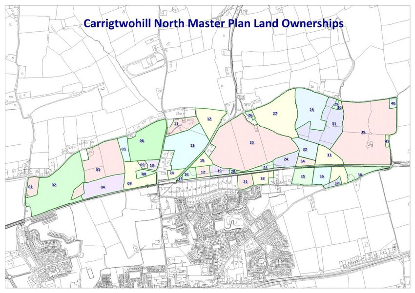
Table of Contents
        4.1        INTRODUCTION ......................................................................................................................................... 51
        4.2        MASTERPLAN PHASES ................................................................................................................................. 51
                                                 .............................................................................................................................. 52
        4.4        MASTERPLAN IMPLEMENTATION................................................................................................................... 57
        4.5        SOURCES OF FUNDING ................................................................................................................................ 62

     List of tables and Figures

     TABLE 2:1 HOUSING LAND SUPPLY ............................................................................................................................... 10
     TABLE 2.2 ECOLOGICAL EVALUATION ............................................................................................................................ 14
     TABLE 3-1 HOUSING PRINCIPLES .................................................................................................................................. 25
     TABLE 3-2 URBAN DESIGN PRINCIPLES ........................................................................................................................... 27
     TABLE 3-3 TRANSPORT AND MOBILITY PRINCIPLES ........................................................................................................... 30
     TABLE 3-4 STREET HIERARCHY ..................................................................................................................................... 35
     TABLE 3-5 WATER SERVICES PRINCIPLES ........................................................................................................................ 36
     TABLE 3-6 FLOOD RISK PRINCIPLES ............................................................................................................................... 38
     TABLE 3-7 GREEN INFRASTRUCTURE PRINCIPLES.............................................................................................................. 39
     TABLE 3-8 OPEN SPACE HIERARCHIES ........................................................................................................................... 42
     TABLE 3-9 COMMUNITY USES PRINCIPLES ...................................................................................................................... 44
     TABLE 3-10 LAND USE ZONINGS................................................................................................................................... 46
     TABLE 4-1 PHASE 1 DEVELOPMENT PROGRAMME ........................................................................................................... 53
     TABLE 4-2 EXTERNAL TRANSPORT WORKS ..................................................................................................................... 54
     TABLE 4-3 PHASE 2 DEVELOPMENT PROGRAMME ........................................................................................................... 55
     TABLE 4-4 EXTERNAL TRANSPORT WORKS ..................................................................................................................... 56

     FIGURE 2.1 COUNTY METROPOLITAN STRATEGIC PLANNING AREA...................................................................................... 11
     FIGURE 2-2 MASTERPLAN SITE LOCATION MAP 1 ............................................................................................................. 12
     FIGURE 2-3 LAND OWNERSHIP .................................................................................................................................... 13
     FIGURE 2-4 TREES AND HEDGEROWS ............................................................................................................................ 16
     FIGURE 3-1CARRIGTWOHILL NORTH FLOOD RISK ............................................................................................................ 39
     FIGURE 3-2 CARRIGTWOHILL NORTH CONCEPT PLAN ....................................................................................................... 48
     FIGURE 4-1 CARRIGTWOHILL NORTH PHASE 1 ................................................................................................................ 52
     FIGURE 4-2 CARRIGTWOHILL NORTH PHASE 2 ................................................................................................................ 55
     FIGURE 4-3 INFRASTRUCTURE REQUIREMENTS ................................................................................................................ 58

ii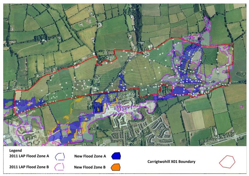
Carrigtwohill North Framework Masterplan 2015

Section 1. Purpose of Study
Carrigtwohill North Framework Masterplan 2015

2

Section 1: Purpose of the Study
1.1 Introduction/Purpose of this Study
1.1.1 This is a framework masterplan study for the development of the lands at Carrigtwohill North (zoned
X-01) in the 2011 Midleton Electoral Area Local Area Plan. Given the multiplicity of landownership
and the complexity of infrastructure provision required, the overall approach taken in this masterplan
study is to provide a framework within which proposals for the development of individual sections
can in the future be co-ordinated towards shared principles.
1.1.2 Carrigtwohill North is located directly to north of the Metropolitan Town of Carrigtwohill and adjoins
the recently reopened Cork-Midleton Railway line and encompasses the new Carrigtwohill Railway
Station. Hence, development at this location will allow for ease of access to the services centre
provided by Carrigtwohill and can contribute to the creation of critical mass of population along the
recently re-opened Cork-Midleton rail line. The Development of such a large site in close proximity to
the suburban rail network offers a major opportunity to provide new homes where residents can gain
easy access to high quality public transport from the outset.
1.1.3 In developing a clear vision and delivery methodology for these lands, development on this site at
Carrigtwohill must deliver a person-centred development built around enhanced opportunities for
walking, cycling and public transport use that provides for a high quality environment for people to
live. The key components of such a place are:
Quality housing to meet the needs of citizens from all walks of life;
Well designed movement corridors (segregated where appropriate);
Effective connectivity to public transport, high quality amenity provision;
Attractive open space offering the opportunity for high quality of life; and
Best practice in overall design and layout.
Sensitive integration of the development into the existing landscape providing for the
protection of environmental resources including biodiversity and water
1.2 Policy Background
1.2.1 The National Spatial Strategy 2002, the South West Regional Planning Guidelines 2010 and the Cork
Area Strategic Plan (CASP) update 2008, all recognise the importance of promoting and developing
the Metropolitan Towns of Cork and in particular to focus future population growth along the railway
line through an integrated land use and transportation strategy. In the context of the focus on
Metropolitan Cork for future population growth it is considered critical that the proposed masterplan
sites in Metropolitan towns like Carrigtwohill are developed in order to achieve the required growth.
1.2.2 In 2005 Cork County Council prepared a Special Local Area Plan for Carrigtwohill to establish an
agreed development framework for the town that would guide development and optimise
development opportunities along the planned re-opening of the Cork-Midleton railway line. Within
the Plan, specific objectives pertain to the preparation of a masterplan for a128ha linear-shaped site
3
Carrigtwohill North Framework Masterplan 2015

            which straddles the railway line both to the north and south. Local roads mark the consecutive
            western and eastern site boundaries. The objectives for the site include the delivery of a new
            residential neighbourhood of up to 3,000 units, appropriate employment development on the site
            through a phased programme of development,

    1.2.3   The Midleton Local Area Plan 2011 which superseded the Carrigtwohill Special local Area Plan
            identifies the X-01 site (Carrigtwohill North) for substantial residential development, with the
            additional provision of employment, educational and community facilities. This plan also sets out in
            detail the main provisions to be contained in the Carrigtwohill North Framework Masterplan.

    1.2.4   It is an objective of the Cork County Development Plan 2014 to maximise new development, for both
            employment      and    housing,   in    the   Metropolitan     towns    served    by   the    Blarney
            Midleton/CobhRailwayline and to enhance the capacity of these towns to provide services and
            facilities to meet the needs of their population. The Cork County Development Plan 2014 has
            therefore identified Carrigtwohill for significant growth with a population target of 11,618 for 2022
            which will require the construction of an additional 3,196 housing units and it is an objective to
            accommodate a substantial portion of this growth target for the town on the Carrigtwohill North
            lands.

    1.2.5   The Cork County Development Plan 2014 therefore identifies Carrigtwohill North as a priority project
            which is proposed in the short term Projects proposed in the short term are projects where
            developments can commence almost immediately when the economy and housing market recovers.
            Cork County Council will invite the appropriate infrastructure agencies to make immediate provision
            for these projects in their capital programmes so that substantial progress can be made during the
            lifetime of the County Development Plan.

    1.3 Previous Masterplans for Carrigtwohill North

    1.3.1   In preparing the previous masterplan for this site the Planning Authority carried out a series of
            consultations with landowners/residents within and adjoining the Masterplan site and with the wider
            Carrigtwohill community.

    1.3.2   A Preliminary Draft Masterplan was prepared in early 2010 and a period of consultation with
            landowners was undertaken which resulted in a Draft Masterplan was prepared for the site for in
            November 2010. Submissions received during the public consultation process raised a number of
            issues, some of which were addressed during the subsequent Local Area Plan process for the
            Midleton Electoral Area. One of the main changes to the Draft Masterplan during the Local Area Plan
            process was the need to undertaken a detail Flood Risk Assessment of the site and Carrigtwohill
            Town. This framework masterplan absorbs the submissions from the previous public consultation
            process undertaken, as well as the result of the detail Flood Risk Assessment done.

4
Section 1: Purpose of the Study
1.3.3 Since the adoption of the 2011 Local Area Plans and the emergence of Spatial Planning and National
Roads Guidelines for Planning Authorities aiming to protect public investment in National Road
Infrastructure it has been recognised that Transport Assessments for some of the larger Masterplan
sites are required in order to examine the transport impacts of the proposed developments on the
local road networks in the future, in accordance with the NRA Traffic and Transport Assessment
Guidelines (May, 2014). A Transport Assessment has been carried out for the Carrigtwohill
development (now published as a supporting background document to this study) in order to assess
its influence on the local road network and to determine the necessary road infrastructure
requirements to accommodate each phase of the development. The main conclusions of the study
have been included in this framework masterplan.
1.4 Amendment to the Midleton Local Area Plan 2011
1.4.1 A number of locations throughout the county have been identified as opportunity sites in the 2011
Local Area Plans, where the preparation of individual Masterplan’s are required .Carrigtwohil North is
one such opportunity site. The Guidelines for Planning Authorities on Local Area Plans state that the
preparation of non-statutory documents/plans (village design statement, environmental
improvement plans or individual site development briefs) to guide specific development proposals is
acceptable as long as they are consistent with the parameters laid down by the statutory plans. This is
further endorsed where it is stated that such non-statutory studies or frameworks, prepared by local
authorities and working within defined policy and objective parameters of the relevant plan, are
appropriate and complementary to the preparation of the statutory Local Area Plan.
1.4.2 This Framework Masterplan once completed will inform an amendment to the Midleton Electoral
Area Local Area Plan 2011. The Framework Masterplan will act as a background planning guidance
document to inform the future development of the site and the Local Area Plan will be amended to
give the Framework Masterplan a statutory footing.
1.5 Role of Other Stakeholders
1.5.1 The County Council alone cannot deliver the necessary infrastructure or other supporting actions
necessary make this development a success. To achieve the principle objectives associated with this
development substantial co-operation between a wide variety of stakeholders is essential. In the area
near this development site, Cork County Council will require assistance in the provision of certain
medium to long term road and public transport infrastructure and improvements comprising:
Amended and improved bus services;
An increased frequency of train service;
Support and funding for these and other transport interventions from the National Transport
Authority; and
5Carrigtwohill North Framework Masterplan 2015
A new junction/interchange on the N25 at the former Amgen Site and ancillary local road
network.
1.5.2 Irish Water is the body responsible for the provision of Water Services infrastructure, the present
Carrigtwohill Waste Water Treatment plan is overloaded , however an upgrade is under construction
and is due for completion in 2015.
1.5.3 There is adequate water supply available, however the requirement for further storage reservoir may
need to be assessed.
1.5.4 In the wider Metropolitan area including Cork City, this development at Carrigtwohill North forms part
of a strategy based on the Cork Area Strategic Plan (CASP) which envisages the implementation of
complementary and co-ordinated land use and transportation initiatives by both City and County
planning authorities. In order to compliment population and new housing development in locations
such as Carrigtwohill North that are well served by the Suburban Rail Network it is critical that urban
regeneration and employment development be prioritised in the City Centre and in locations close to
Kent Station or other stations on the network. With specific regard to the eastern rail corridor that
serves Carrigtwohill it is envisaged that urban improvements and redevelopment in the vicinity of
Kent Station and Cork City centre will assist in making the eastern suburban rail service a viable option
for residents along this rail line, by providing employment attractors to residents living east of the
city. This is a critical requirement in the delivery of Cork’s potential for economic growth based
around a sustainable rail transport system within Metropolitan Cork.
1.5.5 In the short term, this masterplan study seeks to sets out a phased approach to the development of
the site and the delivery of critical infrastructure. The phasing proposals provide for the minimum of
infrastructure investment prior to the commencement of development. Each phase of development is
then linked to the delivery of additional infrastructure
1.5.6 As with any strategic development site, the success or otherwise of this project relies on the support
of all landowners and key infrastructure providers.
6Section 2: Description of the Site Section 2. Description of the Site and its surroundings
Carrigtwohill North Framework Masterplan 2015

8
Section 2: Description of the Site

2.1 Introduction

2.1.1   The purpose of this section is to describe the background to these development proposals and
        highlight relevant features of the Carrigtwohill North site, its’ surroundings and supporting
        infrastructure. The section commences by describing how the development of this site can contribute
        to the overall requirement for new housing in the Metropolitan Strategic Planning Area of which the
        site forms a part. The physical features of the site itself are described and those which require
        retention or specialised treatment during the design of development proposals are highlighted.
        Finally, the section gives a description of the infrastructure that is available locally to support the
        development of the site (particularly water, waste-water and transport infrastructure) and attention
        is drawn to those aspects of the infrastructure framework where significant investment will be
        required in order to deliver the capacity necessary to sustain the development proposals set out in
        this study.

2.2 The Requirement for New Housing in the Cork Metropolitan Area

2.2.1   CSO population forecasts indicate that the population of Ireland is likely to continue growing over the
        next 30 years or so. The 2011 census recorded a population of 4.6 million persons for the State and
        the most recent research from the CSO suggests that this could grow to between 5.0 million and 6.7
        million by the year 2046.

2.2.2   In 2011 the census indicated that the combined populations of the City and County of Cork (519,032
        persons) was about 11.3% of the population of the state. Based on the CSO national projections, the
        population of the City and County could grow to between 550,000 and 770,000 persons by 2046.

2.2.3   Historic trends in the northern and western parts of the county suggest that, despite the national
        population growth trend, the populations of these areas are likely to remain relatively constant. Most,
        if not all, of the population growth in the county is likely to occur within the Metropolitan area close
        to Cork City.

2.2.4   In 2011 the total population of the Metropolitan Area including Cork City was 289,739 persons. Based
        on the preceding paragraphs, the population of this area could grow to between 321,700 and 541,000
        persons by 2046.

2.2.5   To facilitate a co-ordinated approach to planning for population growth, the South West Regional
        Authority issued population ‘targets’ for the year 2022 in the Regional Planning Guidelines issued in
        2010. These ‘targets’ have been used by the City and County Councils to prepare the Draft Joint
        Housing Strategy in January 2013. This indicates that the combined 2022 population target for the
        City and County areas of Metropolitan Cork is 363,891 persons and this figure is being used by both
        City and County Councils in the preparation of Statutory Plans.

2.2.6   In line with national and international trends, the average household size in Cork is continuing to
        decline. In the 2011 census the average number of persons in each household was 2.7 but this is

                                                                                                                   9
Carrigtwohill North Framework Masterplan 2015
expected to decline towards an average of 2.4 by the year 2022. The effect of this, after an allowance
has been made for vacancies etc., is that to house the target population for 2022 (363,891), it will be
necessary to construct over 51,000 new dwellings in the combined City and County Metropolitan
Area.
2.2.7 Over the next 30 years (up to the year 2046) preliminary indications are that Cork City and the
Metropolitan area around it may need to accommodate over 146,000 new households. About 77% of
these (c.118,000) are likely to be 1 or 2 person households rather than larger family units. Although
the majority of these smaller households will be formed by younger people, many are also likely to be
in the older age cohorts. Cork City is likely to be the location of choice for the younger aged 1 or 2
person households, but there is likely to be significant demand in the County areas especially amongst
the older age cohorts in this group.
2.2.8 Although many 1 or 2 person households may well choose to buy or rent a 3 or more bedroom
dwelling the demand for smaller dwellings seems likely to be greater in future years than it has been
in recent years.
2.2.9 Accordingly, there is a requirement to build 31,000 new dwellings within the County Metropolitan
Strategic Planning Area to accommodate the current population target set out in the Regional
Planning Guidelines. In order to meet this demand for new dwellings, the County Council has
identified in its local area plans land suitable for housing development that is estimated will yield a
total of 36,620 new dwellings as follows:
Table 2:1 Housing Land Supply
County Metropolitan Strategic Planning Areas
Housing Land Supply Summary
Residential Land Supply Housing Units
Large Sites including (Masterplan Sites/Strategic 22,713
Development Zones)
Other Zoned land in Main Towns 10,978
Villages 2,137
Rural Housing 1,672
TOTAL 36,620
2.2.10 Of the total housing land supply for the County Metropolitan Strategic Planning Area, 62% derives
from a small number of large development sites which include Water-Rock, Carrigtwohill,
10Section 2: Description of the Site
Shannonpark (Carrigaline), Ballincollig, North Environs (Ballyvolane), Glanmire (Richmond and
Ballinglanna), Blarney (Stoneview), Monard and Cobh.
Figure 2.1 County Metropolitan Strategic Planning Area
2.2.11 In order to support Government investment in infrastructure (particularly that in suburban rail and
water infrastructure services in the Cork area) and limit the need for further investment in the short
term, the County Council has prioritised its approach to the development of these sites. The
Midleton, Carrigtwohill and Carrigaline sites are supported by existing or planned investment in rail or
water infrastructure therefore these masterplans form the first tranche for which masterplans have
been prepared.
2.3 Site Context
2.3.1 Carrigtwohill is located along the N25 Cork – Waterford route and is designated as a Metropolitan
Town within the County Metropolitan Strategic Planning Area. The town has experienced significant
growth and development in the last decade (approximately 25%pa) and the 2011 population census
counted 4551 persons. The draft County Development Plan 2013 has identified a target population
for Carrigtwohill by 2022 of 11,618.
2.3.2 A primary aim for Carrigtwohill, as set out in the draft County Development Plan 2013 and building on
the success of the re-opening of the rail line, is to facilitate its growth as an integrated employment
centre while maintaining its attractive setting within the Metropolitan Cork Green Belt.
2.3.3 The framework masterplan area (shown as X-01 on the map below) is located to the north of the
reopened Cork –Midleton Railway line and Carrigtwohill Town Centre. To the south of the railway
11Carrigtwohill North Framework Masterplan 2015
line, a major residential development is in the process of being completed. This development
includes a wide variety of house types from semi-detached units to terraces to a four story apartment
complex. Additional retail development has also been zoned to the south of this site. To the north
and east the site is bounded by the A1 Metropolitan Cork Green Belt, which is the most protected
part of the Green Belt particularly because of its location on a prominent ridge overlooking the town.
Figure 2.2 Masterplan Site location map
2.4 Landownership
2.4.1 The total area of the Framework Masterplan site is 128 hectares. There are 41 principle landowners,
as shown on the landownership map below.
12Section 2: Description of the Site
Figure 2.3 Land Ownership
2.5 Physical and Natural Features
2.5.1 Cork County Council engaged consultants (Limosa Environmental) to prepare a Preliminary Ecological
Appraisal of the site. The purpose of the appraisal is to gather baseline data for a site through desk-
top studies and walkover surveys in order to identify notable species and habitats and evaluate the
ecological features on the site to identify potential impacts of proposed development and provide
necessary mitigation. Ground conditions within the framework master plan area are generally dry;
however, the lands adjoining the Railway line can be wet due to periodic flooding. A recently
commissioned detailed Flood Risk Assessment indicated that 16.0 ha or 13.77% of the site is at
serious flood risk. This detailed flood risk was not known during the preparation of the previous draft
masterplan in 2010.
Topography
2.5.2 The topography of the study area, is gently sloping from north to south, but is a little steeper towards
the road to the north of the site. The height differential across the site is in the range of 0-40 metres.
The lands are slightly below the railway to the south while approaching the northern boundary of the
site and upwards the land rises more steeply which may present more challenges for development.
2.5.3 This generally southerly slope gives an opportunity for efficient and cost effective drainage and house
orientation
13Carrigtwohill North Framework Masterplan 2015
Landscape
2.5.4 Primarily, the land parcels are enclosed by hedgerows and is predominantly farmland being
interspersed with a number of single site houses. The roads which bound the site are lightly
trafficked, hedgerow enclosed boreens and have a predominantly rural character. There are number
of areas of scrubland which may be of limited ecological value. The lands contain field drains which
channel water through these lands and further towards the town to the south. There is evidence of
water logging in places.
Archaeology and Cultural Heritage
2.5.5 There are no Record of Monument and Places (RMP) sites within the proposed site.
Ecology
2.5.6 The preliminary ecological value of habitats recorded in the Carrigtwohill North study area was
assigned following an ecological appraisal which was carried out in January 2015. These values are
shown in Table 2.2 and the more noteworthy habitats are discussed below;
2.5.7 Proposals contained in this masterplan have been designed to ensure that areas of ecological
importance identified in the Masterplan Area are protected and retained.
Table 2.2 Ecological Evaluation
Habitat Preliminary Ecological Value Notes
Improved agricultural grassland Low local Relatively low value for
wildlife
Wet grassland Moderate -high local *further survey and
assessment is required to
confidently assign value.
Grassland / Willow Scrub Low local Habitat surrounding
recent housing
developments.
Arable crops Low local Relatively low value for
wildlife.
Buildings and artificial Low local
surfaces
Streams Moderate local* *further survey and
assessment is required to
confidently assign value.
Hedgerows Moderate Local
Treelines Moderate - High local See further discussion
below
14Section 2: Description of the Site
Habitats of greater ecological sensitivity
Streams
2.5.8 The presence of stream/ditches with a landscape contributes to the biodiversity of the area primarily
because watercourses support species or species assemblages that are not found in other habitat
types. By their nature, streams also provide ecological connectivity. The mid and eastern
watercourses are bounded by treelines present on OS 6” maps and are likely to play an important role
as a wildlife corridor.
When streams are bounded by treelines , the aerial insect fauna associated with both the stream and
treelines may add to the importance of these habitats as foraging corridors for bats ( see futher text
on treelines below).
2.5.9 The biodiversity value of all watercourses and their natural buffers in the Carrigtwohill North site
should be protected and enhanced and the development of amenity walks along watercourses should
be incorporated at the detailed design stage of each phase of development
Natura 2000
2.5.10 The study area is not the subject of any conservation designation, proposed, candidate, or otherwise,
under current legislation. The range of habitats present within the study area is limited with a number
of common fauna species present. The lands are mostly kept as grassland with the exception of the
streams and existing hedgerows. Cork Harbour SPA – 4030 is located within 2.5 km of the site,
however, there are no Natura 2000 sites within, adjacent or in close proximity to the boundary of the
site.
Trees and Hedgerows
2.5.11 The site generally consists of farmland under a mixture of grass and tillage. There are substantial
groups of trees in the West, South , Centre and North East of the site
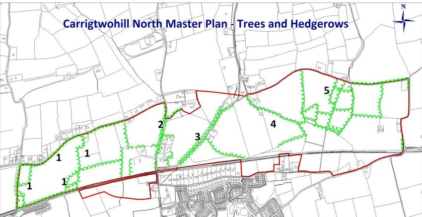
2.5.12 Tree lines and hedgerows have high intrinsic ecological value and contribute to the biodiversity of the
site as well as having the potential to support a range of nesting, resting, breeding, foraging and
commuting species. Treelines dominate as field boundaries within the Masterplan site, and whilst all
have ecological value , five areas in particular are deemed to be of greater importance (refer to Figure
2.4). It is an objective to protect/enhance these important hedgerow and treelines which are
considered to be of moderate to high ecological value.
15Carrigtwohill North Framework Masterplan 2015
Figure 2-4 Trees and Hedgerows
Wet Grasslands/ Scrub
2.5.13 The wetland area in the south-east of the site which lies adjacent (north) of the railway line, is
unmanaged and currently provides a ‘wilderness’ area for wildlife, and together with mature
treelines, streams, and unmanaged habitat to the east, these habitats are likely to be the most
biodiversity-rich area within the Masterplan site .There is a potential that the habitats support
breeding mammals, and the potential for a Badger sett cannot be discounted.
2.5.14 It is an objective to protect/enhance these important wetlands which are considered to be of
moderate to high ecological value.
Existing Buildings
2.5.15 The site has a number of existing buildings, mainly located on the periphery of the site and
predominantly residential dwellings. The geo-directory counts show that there are approximately 13
residential buildings and 3 commercial premises on the site. It is the intension that most of the
residences will be incorporated into the design of the development at the appropriate phase.
2.6 Existing Infrastructure
Transport
Rail Services
2.6.1 A total of 21 trains operate daily each way between Cork and Midleton, with services running every
30 minutes at peak times, and every hour at off-peak times, Monday to Friday. Seventeen trains each
way operate on Saturdays and nine trains operate each way on Sundays. All trains serve the new
station Carrigtwohill, as well as Midleton, Glounthaune, Little Island and Kent Station, Cork.
16Section 2: Description of the Site
2.6.2 Each train is a two-carriage commuter train, with capacity for 320 passengers, including seating for
129 passengers. The operating platforms have been built to accommodate future expansion to four-
carriage trains with an operational capacity of every 15 minutes.
2.6.3 As well as offering a strong commuter service, the new timetable offers excellent connections to the
Cork-Dublin Intercity service, maximising the benefit of this new infrastructure.
Pedestrians and Cyclists
2.6.4 At present there are no dedicated cycle routes available within the town of Carrigtwohill. Safe and
direct cycle routes are required from existing residential areas to the town centre and business park
to encourage cycling as a safe and sustainable mode of transport and as a means of travel to the
railway station where covered cycle stands are available.
2.6.5 The quality of the pedestrian network on the Main Street is reasonable with varying footpath widths.
There are good links between the IDA Business Park and the town centre. Elsewhere both the quality
and provision of pedestrian links varies from substandard to no provision.
2.6.6 There are a number of good quality pedestrian routes in the perimeter of the settlement which have
been delivered as part of recent residential developments but connectivity between these areas and
the town centre. is poor in places.
2.6.7 Most of the town and the Masterplan site are within the accepted 10 minute (or 800m) walking
distance of the railway station so opportunities exist to expand and maximise connectivity and direct
pedestrian routes to the station from various locations within the town.
Bus Services
2.6.8 The existing bus network serving Carrigtwohill at present functions primarily as an interim stop along
a wider route operating between Cork City and a range of settlements in East Cork. There is no bus
station within the town but there are a number of bus stops at staggered locations on the Main
Street.
Roads
2.6.9 Carrigtwohill is well served off the N25 National Primary Road, which links Cork City via Dunkettle
Interchange to Midleton, Youghal, Waterford and Rosslare Harbour. Together with Midleton, it also
serves two other towns (Carrigtwohill and Cobh (via R624)) identified by the County Development
Plan 2014 as locations for major population growth in order to support the overall strategy for the
Cork ‘Gateway’. The County Development Plan 2014 makes provision for a combined future
population growth of 18,847 persons in these three towns. In addition, to the east of Midleton, the
N25 also serves Youghal which although not the subject of such significant growth proposals, has also
become a popular location for those who commute to the Cork area for employment.
17Carrigtwohill North Framework Masterplan 2015
2.6.10 From the Dunkettle interchange (which gives access to the M8 and N40) the N25 is a dual carriageway
(grade separated) road as far as Carrigtwohill. From Carrigtwohill to Midleton the road is dual
carriageway but with at grade junctions with minor roads. There are 2 off ramps from the N25 serving
the west and the centre of the town.
2.6.11 The modernised route west of Carrigtwohill generally has capacity to accommodate the additional
traffic that planned population growth in this corridor will cause. However, the lower standard route
between Midleton and Carrigtwohill will require modernisation to accommodate all the planned
growth. The scope and timing of these improvements will be influenced by the extent to which the
Government’s targets for modal shift to more sustainable modes of transport can be achieved.
2.6.12 The town also has a hierarchy of roads and streets which reflects the incremental growth of the
settlement from a small rural village to a Metropolitan Town. Access from Carrigtwohill town centre
to the site is northwards along Station Road which then splits north of the railway line into the
(L3606) and the L3603,these run directly through the site. Alternatively, the site can be accessed via
the L3616 (Wises Bridge) from the west. The site is also accessible from the east from the L7640
(Ballyadam Bridge). The L3615 runs along the northern boundary of the site.
2.6.13 Whilst some improvement works have been undertaken on all 3 bridges in the past when the railway
line was re-laid, pedestrian access across the bridges is poor.
2.6.14 In order to inform this framework masterplan, a traffic and transport assessment has been carried out
on behalf of the County Council by ‘MHL’. The assessment, utilising up-to-date traffic counts and
modelling techniques, examined a number of alternative approaches to the phasing of development
and the delivery of road infrastructure and transportation improvements with the aim of identifying a
strategy for the development that would make a significant contribution to achieving the
Governments targets for modal shift and, at the same time, provide the greatest protection to the
carrying capacity of existing and planned road infrastructure. This assessment is separately available
as a background document to this framework masterplan.
2.6.15 Delivering enhanced levels of modal shift will require the commitment of transport operating and
funding agencies and also the commitment of the planning authorities (including Cork City Council) to
take appropriate steps to focus employment development on locations served by the public transport
network.
Water, Waste Water and Surface Water disposal
Irish Water
2.6.16 The Government has established Irish Water to assume responsibility for the operation and delivery
of public water services (water and wastewater) on a national basis. The Water Services (No. 2) Act
2013 provided for the transfer of water services (water and wastewater) functions from the 34 Local
18Section 2: Description of the Site
Authorities to Irish Water. It has taken over responsibility for water services from the Local
Authorities from 1st January 2014.
2.6.17 Irish Water is responsible for the operation of public water services (water and wastewater) including
management of national water services assets, maintenance of the water services system, investment
and planning, managing capital projects and customer care and billing. Irish Water will make capital
and operational investment decisions regarding the country’s national water infrastructure.
2.6.18 Irish water has published its Proposed Capital Investment Plan (2014-2016) outlining the indicative
investment priorities in water services infrastructure over this period. Irish Water has also
commenced work on a 25 Year Water Services Strategic Plan (WSSP) which is intended to state the
objectives of Irish Water in relation to the provision of water services for a 25 year period and the
means by which Irish Water proposes to achieve these objectives. Capital Investment Plans will be
adjusted as required to meet the objectives and priorities of the 25 Year Water Services Strategic
Plan. Cork County Council has made submissions to Irish Water concerning both the Proposed Capital
Plan (2014-2016) and the 25 Year Water Services Strategic Plan.
Drinking Water
2.6.19 A water supply is available to service the Carrigtwohill Masterplan Area and also the target population
for Carrigtwohill contained in the Draft County Development Plan 2013. This is as a result of the
extension of the Cork Harbour and City Water Supply Scheme with the installation of a large diameter
trunk watermain from Little Island to Carrigtwohill (Hedgy Boreen) in 2006/2007.
2.6.20 There is a 700 mm diameter public trunk watermain running through the Masterplan site in a west-
east direction adjacent to the northern side of the Cork-Midleton railway line. There is a 450 mm
diameter trunk watermain running in a north-south direction which crosses under the Cork-Midleton
railway line.
2.6.21 A new watermain network is required within the proposed Masterplan Area to serve individual
developments. This network must be designed and constructed so that it can be taken in charge by
Irish Water. The issue of storage for the overall Carrigtwohill area may need to be addressed.
2.6.22 As Irish Water is now the relevant body dealing with water services issues it will be necessary for a
Developer to obtain a connection agreement from Irish Water for water supply.
Waste Water
2.6.23 Disposal of wastewater from the Carrigtwohill North Masterplan Area will be by way of connection to
the Irish Water wastewater infrastructure and by no other means
2.6.24 Currently in Carrigtwohill the existing Waste Water Treatment plant has a capacity of 8,500 PE,
however at present it is overloaded
19Carrigtwohill North Framework Masterplan 2015
2.6.25 Construction of a new waste water treatment plant has commenced adjacent to the existing plant at
Rossmore which will cater for a capacity of 30,000 PE with an option to expand to 45,000 PE in the
future. This should alleviate the current effluent contamination of the harbour.
2.6.26 A new network of sewers is required to be installed within the Masterplan Area to serve the proposed
individual developments. These must be designed and constructed so that they can be taken in
charge by Irish Water. This new sewer network will connect into the existing Carrigtwohill sewer
infrastructure.
2.6.27 As Irish water is now the relevant body dealing with water services issues it will be necessary for a
Developer to obtain a connection agreement from Irish Water for wastewater disposal and
treatment.
Surface Water
2.6.28 It is proposed to carry out a comprehensive Sustainable Urban Drainage Study ( SUDS) to identify the
issues and solutions for the attenuation and disposal of surface water.
Flood Risk
2.6.29 Three number storm sewers were constructed under the railway line prior to the reopening of the
Cork-Midleton line.
2.6.30 A number of streams run in a north-south direction through the Masterplan Site.The Lee CFRAMS
report identified areas at risk of flooding in the south of the town and recommended a more detailed
flood risk assessment study for the whole town, including the master plan site. The Flood Risk
Management Guidelines require that future development in the first instance Is avoided in areas
indicated as being at risk of flooding. Flooding is discussed in further detail in Section3 ( Masterplan
proposals)
2.6.31 As a result of this a more detailed flood risk assessment has been carried out on behalf of Cork County
Council by JBA Consultants which identified a number of areas within the framework master plan site
which are considered at risk of flooding
2.6.32 The report recommends that a groundwater level monitoring network should be established. This
should incorporate existing boreholes and monitoring wells in the catchment. A detailed well and
karst survey should be completed to identify any additional bedrock boreholes and karst features and
where an insufficient number of boreholes are identified, new boreholes should be drilled at key
locations to fill data gaps. A number of other steps to establish a monitoring network are also detailed
in the full report.
2.6.33 It further recommends that gauges be installed to provide continuous monitoring at springs and
sinking streams in order to quantify ground water discharge and surface water recharge rates.
20Section 2: Description of the Site
2.6.34 Where possible development other than that catering for Open Space purposes should be avoided in
areas identified as being at risk of flooding.
Waste Management
2.6.35 Cork County Council no longer provides a refuse and recyclables collection service. It will be for a
private operator to provide a service for the masterplan site. There is a public civic amenity site south
of the town at Rossmore
Schools
2.6.36 Carrigtwohill is currently served by 2 primary schools, (1 all girls, 1 all boys) and an all girls secondary
schools. The three schools are located approximately 1 km south of the master plan site. The
Department of Education is proposing to build a new primary and secondary school in Carrigtwohill.
Broadband
2.6.37 Significant broadband investment is required in order to facilitate the technological requirements of
both potential residents and businesses in Carrigtwohill. Currently it is not proposed to include
Carrigtwohill in the Metropolitan Area Network Scheme
Power and Telegraph Lines
2.6.38 An existing high voltage (220kv) power line transverses the site. The costs and major undertaking
involved in relocating this line are prohibitive.
2.6.39 A 40 kv line also transverses the site and this can be grounded and diverted at fairly minimum cost.
21Carrigtwohill North Framework Masterplan 2015
2.7 Issues – Carrigtwohill North
2.7.1 Issues to be addressed by this Masterplan include:
There is an urgent requirement for development to commence to meet the need for housing in a
location where sustainable transport services are already in existence.
Stormwater Urban Drainage Systems (Suds) study needs to be undertaken for the site.
Secure the co-operation and support of landowners.
Secure co-operative strategies from other public agencies which include; Irish Water, Irish Rail, the
National Roads Authority and the National Transport Authority.
Maximize the potential for modal shift from car based transport to rail transport in order to achieve
National Targets and make best use of existing and planned transport infrastructure.
Co-ordinate planning policies to create employment opportunities along the rail corridor (e.g. in Cork
City in close proximity to Kent Station).
Implement the Transport Assessment recommendations.
Recognize the ecological importance of parts of the site (treelines, wetlands and bio-diversity
habitats) and implement the recommendation of the Ecological Appraisal Report.
An existing high voltage (220Kv) power line transverses the site. The costs and major undertakings
involved in relocating this line are prohibitive.
The site although a significant asset is also a physical barrier to a more seamless integration with the
established settlement and connectivity is paramount.
Significant broadband investment required in order to facilitate the technological requirements of
both potential residents and businesses on the Masterplan site.
22Section 3: Framework Masterplan Proposals Section 3. Framework Masterplan Proposals
Carrigtwohill North Framework Masterplan 2015

24
Section 3: Framework Masterplan Proposals
3.1.1 This section sets out the vision for the development of Carrigtwohill North and its guiding principles in
the areas of Housing, Urban Design, Transport and Mobility, Green Infrastructure, Open Space and
Recreation, Community Uses, Water Services and Flood Risk. These principles should be used to guide
the future development of Carrigtwohill and its detailed proposals in the planning policy process and
in future detailed design plans. In preparing applications for planning permission, intending
developers must demonstrate that there proposals have addressed the principles set out in this
document.
3.1.2 The overall vision for the development of these lands at Carrigtwohill North is informed by the 2011
Carrigaline Local Area Plan X-01 Zoning Objective. All informing decisions for the Carrigtwohill North
development should be assessed within the context of this stated vision:
Provide a framework plan for a new residential neighbourhood in Carrigtwohill that will enable the
town to expand to meet the growth targets of the Cork County Development Plan 2014 and achieve
modal shift to support the use of the suburban rail line from Midleton to Cork City. In order to
achieve a properly co-ordinated development, it will be developed in accordance with a framework
plan for the area that has been approved by the County Council through consultation with the
relevant landowners and key stakeholders.
3.2 Housing
3.2.1 This section sets out the general planning policies and principles for the provision of housing in
Carrigtwohill North. In addition it also sets out guidance on the approach to housing density, housing
mix and social housing. The following key housing principles should underpin the development of the
development;
Table 3-1 Housing Principles
Principles
To achieve a maximum of 2,950 dwelling units as part of the overall masterplan development.
Ensure the provision of an appropriate housing mix; all applications for multi unit residential
developments should be accompanied by a statement of housing mix which will facilitate the
proper evaluation of the proposal relative to the demographic and housing needs of
Metropolitan Cork.
Consider the needs of the older population cohort when planning the design and mix of
housing.
Make provision for housing that is capable of future expansion/adaptation to meet the future
needs of occupants.
25Carrigtwohill North Framework Masterplan 2015
Provide for Social & Affordable Housing through Part V of the Planning & Development Act
2000.
Ensure overall compliance with the Cork Planning Authorities Revised Draft Joint Housing
Strategy (December 2013).
Provision of high quality and energy efficient housing in an attractive place to live
Density
3.2.2 It is a target of this plan to achieve the development of between 2500-3,000 dwelling units as set out
in the 2011 Midleton Local Area Plan. The site comprises approximately 128ha of which
approximately 95ha will be developed for housing at 28 units per hectare. A medium density of 30-50
units per hectare will allow a range of house types to be provided that both supports rail public
transport while also providing a choice of units for family needs. While restrictive policies are in place
to protect rural landscapes from urban-generated housing, support is required in the provision of
attractive alternatives for family housing in developments like Carrigtwohill North. Hence, this project
will aim to provide a mix of dwelling types from smaller 2 bedroom units to 4/5 bedroom units at an
overall density level that supports public transport by allowing higher density development to be
located in close proximity to the existing railway station..
Housing Mix
3.2.3 It is an objective of the County Development Plan to require the submission of a Statement of
Housing Mix with all applications for multi-unit residential development in order to facilitate the
proper evaluation of the proposal relative to the strategic objectives of the plan. A balanced mix of
house types in all new housing developments is essential in order to provide a choice of housing,
suitable to all age groups and persons at different stages of the housing cycle. A Housing Needs
Analysis for developments in Carrigtwohill North will also be required in order to demonstrate the
appropriateness of schemes put forward to ensure they match local demographics and future
demographic needs.
3.2.4 The majority of households over the next 20 years will be smaller in size consisting of 1-2 persons and
the city is considered to be a good location for the supply of the majority of smaller units to
accommodate this emerging smaller household size. However, this site and other sites throughout
Metropolitan Cork shall make supplementary provision for some smaller units in higher density
enclaves at suitable locations closest to the existing and proposed rail stations and the
neighbourhood centre. The provision of these units at these locations does not exclude smaller units
on other residential sites throughout the masterplan; all developments within the overall masterplan
site can include smaller units to meet market requirements. A higher standard of design will be
required in higher density areas. Outside those higher density areas closest to the rail line a mix of
26Section 3: Framework Masterplan Proposals
3/4/5+ units will be desirable according to market conditions in order to achieve the residential
targets for the site.
Social Housing
3.2.5 The Cork Planning Authorities Draft Joint Housing Strategy December 2013 and the County
Development Plan 2014 require that 14% of new housing development is reserved for the purpose of
‘Part V’ social housing and/or specialised housing needs. The actual mechanism used to satisfy the
Part V requirement will be the one that best facilitates the development of a strong, vibrant, mixed
tenure community. The options for the discharge of Part V obligations are set out in the Joint Housing
Strategy.
3.3 Urban Design
Introduction
3.3.1 Urban design has a key role to play in creating and maintaining successful places. Urban design
includes the way places look, work and feel, it considers the connections between places and
buildings; the character of the built environment and the processes used for ensuring successful
villages, towns and cities. The following design principles should influence the layout and design of
the Carrigtwohill development:
Table 3-2 Urban design principles
Principles
To achieve development areas with a distinctive character in terms of appearance of
surroundings and buildings. This can be achieved through the inclusion of positive
characteristics such as innovative design, reference to topographical and historical features
and the inclusion of individual focal points.
The layout of the site should achieve a high standard of connectivity and permeability
through the provision of good walking and cycling connections.
Give priority to the provision of high quality public realm.
To achieve a unique, innovative and distinctive design of houses with high quality finishes and
materials.
All residential developments on site will require the submission of Urban Design Statements
that are guided by; The Guidelines on Sustainable Residential Development in Urban Areas
(2008), its companion documents the Urban Design Manual, Cork County Councils published
Making Places: a Design Guide for Residential Estate Development 2011 and the Design
Manual for Urban Roads and Streets (2013) as best practice guides in the provision of
sustainable residential development.
27You can also read


