Substantial increase in Pilgangoora Resource to 309Mt confirms its status as the world's premier hard rock lithium project
←
→
Page content transcription
If your browser does not render page correctly, please read the page content below
ASX / MEDIA ANNOUNCEMENT                                     Monday, 6 September 2021

Substantial increase in Pilgangoora Resource
to 309Mt confirms its status as the world’s
premier hard rock lithium project
LANDMARK 39% INCREASE FOLLOWS INTEGRATION OF THE NGUNGAJU
RESOURCE AND HIGHLY SUCCESSFUL DEVELOPMENT DRILLING PROGRAMS
KEY POINTS
   •   Discovery of new pegmatite domains, together with integration of the Ngungaju
       Resource, leads to a substantial increase in the JORC 2012 Mineral Resource for
       Pilbara’s 100%-owned Pilgangoora Tantalum-Lithium Project in WA, including:
        o 39% increase in the total Measured, Indicated and Inferred Resource to 308.9
          million tonnes grading 1.14% Li2O, 105ppm Ta2O5 and 0.59% Fe2O3,
          containing 3.5 million tonnes of lithium oxide and 71.7 million pounds of
          Ta2O5;
        o 59% increase in the total Measured and Indicated Resource to 210.2 million
          tonnes grading 1.17% Li2O, 103ppm Ta2O5 and 0.56% Fe2O3, containing 2.46
          million tonnes of lithium oxide and 47.7 million pounds of Ta2O5; and
        o with an increased cut-off grade of 0.5% Li2O, the total Measured, Indicated
          and Inferred Lithium Resource amounts to 277.2 million tonnes @ 1.22% Li2O
          containing 3.4Mt of lithium oxide, highlighting the exceptional nature of the
          resource before tantalum by-product credits.
   •   The upgraded Mineral Resource includes all of the results from the 2021 exploration
       and development drilling campaign adjacent to the historical Altura tenement
       boundary, together with the integration of the Mineral Resource for the former
       Altura Lithium Operations acquired earlier this year.
   •   Additional resources defined from the 2021 exploration program will lead to an
       expansion in the mining envelope and pit inventory of the combined South Pit
       areas, with outstanding potential for further growth with ongoing drilling.
   •   The new integrated Mineral Resource will underpin a new Ore Reserve estimate for
       Pilgangoora, scheduled for completion by October 2021.

Australian lithium producer, Pilbara Minerals Limited (Pilbara Minerals – ASX: PLS) is
pleased to announce a further substantial increase in the Mineral Resource at its flagship
100%-owned Pilgangoora Lithium-Tantalum Project in WA’s Pilbara region to 308.9 million
tonnes, reinforcing its position as the world’s premier hard rock lithium operation.
The updated Mineral Resource, which represents a 39% increase in total resource tonnage
compared with the depleted resource statement as at 30 June 2020, now comprises a total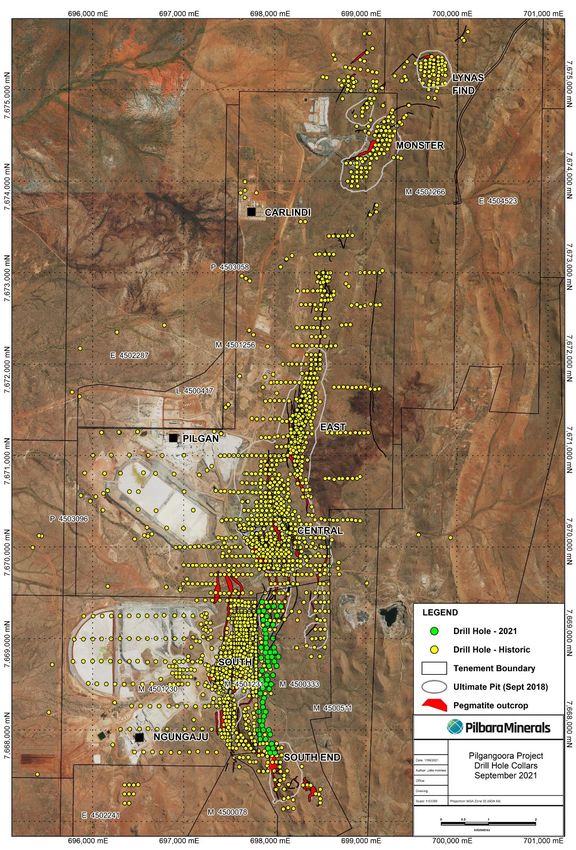
of 308.9 million tonnes grading 1.14% Li2O and 105 ppm Ta2O5, containing 3.5 million tonnes
of lithium oxide and 71.7 million pounds of Ta2O5.

Pilbara Minerals’ Managing Director and CEO, Ken Brinsden, said: “This landmark Resource
upgrade is another clear indication of Pilgangoora’s position as the world’s premier hard-
rock lithium asset. The scale of the endowment is quite remarkable, with the integration
of the adjoining Ngungaju Resource, combined with highly successful development and
drilling programs, taking our Resource inventory well and truly to the next level.

“We are looking forward to completing an updated Ore Reserve next month that will
underpin operations for many decades to come. Against the backdrop of surging global
demand for lithium raw materials, Pilgangoora is incredibly well positioned to play a
pivotal role in the accelerating global energy transformation.”

                     Figure 1 – Pilgangoora – A globally significant hard rock resource

Sources: Published resource estimates by project owners. Note that resource estimates for projects other than Pilgangoora may have been prepared
under different estimation and reporting regimes and may not be directly comparable. Pilbara has not verified, and accepts no responsibility for, the
accuracy of resources estimates other than its own. Readers should use appropriate caution in relying on this information.

                                                                                                                                                   2
JORC 2012 MINERAL RESOURCE UPDATE

The updated JORC 2012 compliant Mineral Resource incorporates all historical data
including drilling data acquired through a number of exploration campaigns completed by
Pilbara Minerals between November 2014 and June 2021. The update also includes the
integration of the former Altura Lithium Operations Mineral Resource.

The estimation was carried out by independent resource consultancy, Trepanier Pty Ltd,
resulting in the estimation of Measured, Indicated and Inferred Resources. The reporting of
all domains (using a cut-off of 0.2% Li2O and depleted to end of June 2021) results in a
Measured, Indicated and Inferred Mineral Resource estimate (Table 1) totaling:

      •   308.9 million tonnes grading 1.14% Li2O containing 3.5 million tonnes of Li2O

    Table 1 – Pilgangoora Project – Depleted Mineral Resource (using 0.2% Li2O cut-off)
                               Li2O       Ta2O5       Li2O       Ta2O5        Factored
     Category       Mt         (%)        (ppm)        (T)      (M lb)        Fe2O3 (%)
    Measured            21.5     1.35         133         291,000          6.3        0.50
    Indicated          188.7     1.15         100       2,172,000         41.4        0.56
    Inferred            98.8     1.06         110       1,046,000         24.0        0.67
      TOTAL            308.9     1.14         105       3,509,000         71.7        0.59

The envelope was wire-framed using both geological logging information (in particular
logging of zoning within the pegmatite) and assay data for Li 2O, Ta2O5 and Fe2O3. Table 2
below illustrates the breakdown of the resource by area, and Figure 4 below shows a typical
cross-section through the northern end of the Central Pit (pit surface, July 2021) showing
the typical distribution of Measured, Indicated and Inferred categories.

If a lithium cut-off of >0.5% is used in global resource reporting, this results in a reduction in
tonnage but provides a significantly higher-grade resource (Figure 2):

          •     277.2 million tonnes @ 1.22 Li2O, containing 3.4 million tonnes of Li2O

Details of the drilling data used for the estimation, site inspection information and the
quality control checks completed on the data are documented in Appendices 1 and 2
(JORC Tables 1 to 3). Figure 3 below illustrates the distribution of the pegmatites and their
domains.

Significant exploration upside remains within the project area, with mineralisation
remaining open at depth within all the defined pit areas and other potential exploration
targets particularly to the east of the newly acquired Ngungaju deposit.

                                                                                                 3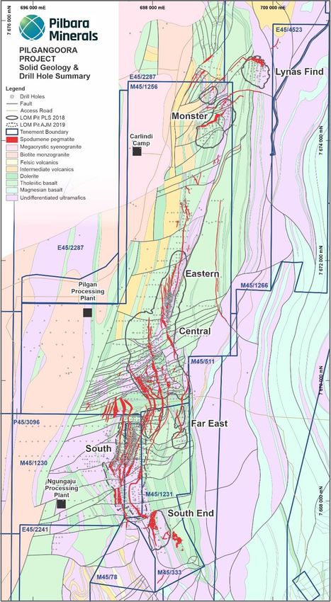
Figure 2 – Pilgangoora – Grade vs. Tonnage curves for the total lithium resource

Figure 3 – Oblique View (looking -45/065) of the mineralised domains (pegmatites)
                              modelled in LeapfrogTM

                                                                                    4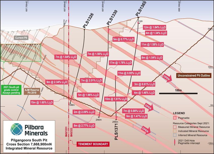
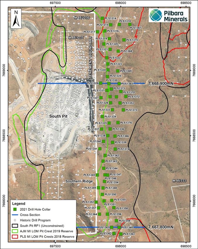
Figure 4 – Cross Section 7670050mN- Central Pit Area

Figure 5 – Cross Section 7668900mN- showing 2021 Resource development drilling to the
east of the Former Altura Lithium Operations tenement boundary

                                                                                    5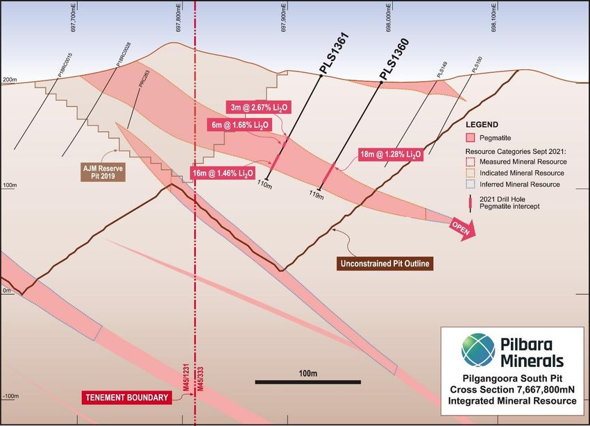
Figure 6 – Cross Section 7667800mN- showing 2021 Resource development drilling to the
east of the Former Altura Lithium Operations tenement boundary

Figure 7 – View from Southern Ridge over- looking South Pit and expanded resource area
to east of the former Altura tenement boundary.

                                                                                     6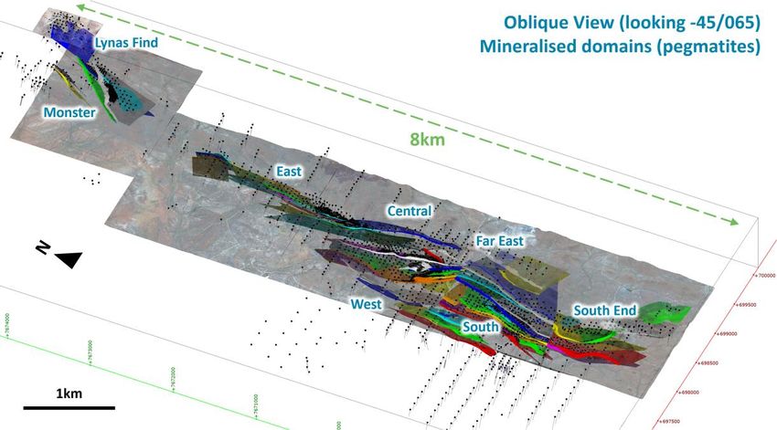
Figure 8 – Drill Hole Location Plan – Pilgangoora Project Area

                                                                 7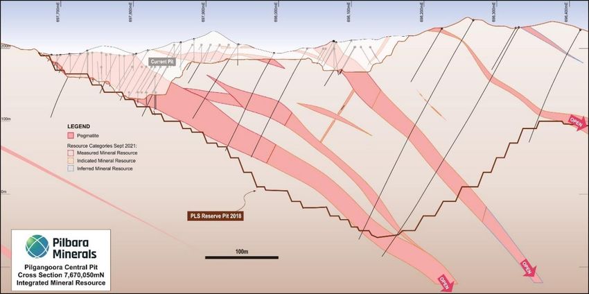
Figure 9 – 2021 RC Drill Hole Location – South Pit

                                                     8
Table 2 – Pilgangoora Project – Mineral Resource Breakdown by Area
                                                  Ta2O5               Ta2O5        Factored
    Area         Category     Mt       Li2O (%)   (ppm)   Li2O (T)    (M lb)       Fe2O3 (%)
 Central       Measured         9.5      1.38      111      130,000         2.3      0.44
               Indicated       72.9      1.28      110      936,000        17.6      0.55
               Inferred        38.4      1.28       92      490,000         7.8      0.60
               Combined       120.8      1.29      104    1,557,000       27.7       0.56

 Eastern       Measured          4.9    1.47       232       72,000        2.5       0.52
               Indicated        10.2    1.18       251      120,000        5.6       0.73
               Inferred         13.6    1.11       261      151,000        7.8       0.81
               Combined         28.7    1.20       253      343,000       16.0       0.73

 Far East      Measured            -                              -          -
               Indicated         7.2    1.27       94        91,000        1.5       0.63
               Inferred          4.3    1.17       75        50,000        0.7       0.90
               Combined         11.5    1.23       87       141,000        2.2       0.73

 South         Measured          5.4    1.21       82        65,000        1.0       0.61
               Indicated        80.0    1.01       71       810,000       12.6       0.54
               Inferred         24.6    0.80       62       198,000        3.3       0.63
               Combined        110.1    0.98       70     1,073,000       16.9       0.57

 South End     Measured            -                              -          -
               Indicated         6.4    1.06       73        68,000        1.0       0.56
               Inferred          3.1    0.76       67        23,000        0.5       0.61
               Combined          9.5    0.96       71        91,000        1.5       0.58

 West          Measured            -                              -          -
               Indicated         0.2    0.79       82         1,000        0.0       0.45
               Inferred          8.4    0.80       114       67,000        2.1       0.82
               Combined          8.6    0.80       114       69,000        2.1       0.81

 Monster       Measured          1.7    1.37       140       24,000        0.5       0.45
               Indicated         6.7    1.18       140       79,000        2.1       0.54
               Inferred          4.0    1.06       134       42,000        1.2       0.60
               Combined         12.4    1.17       138      145,000        3.8       0.54

 Lynas Find    Measured            -                              -          -
               Indicated         5.1    1.31       89        67,000        1.0       0.61
               Inferred          2.4    0.98       100       23,000        0.5       0.74
               Combined          7.5    1.21       93        91,000        1.5       0.65

 TOTAL         Measured         21.5    1.35       133      291,000        6.3       0.50
               Indicated       188.7    1.15       100    2,172,000       41.4       0.56
               Inferred         98.8    1.06       110    1,046,000       24.0       0.67
               Combined        308.9    1.14       105    3,509,000       71.7       0.59

Note: Appropriate rounding applied

                                                                                               9
GEOLOGYThe           Pilgangoora
                                                            Lithium-Tantalum deposit is
                                                            located on the western flank of
                                                            the East Strelley greenstone
                                                            belt, in a sequence of highly
                                                            deformed, fault bounded mafic
                                                            dominated supracrustal rocks,
                                                            which protrude into the Carlindi
                                                            Batholith. Lithologies within the
                                                            project area are dominantly
                                                            tholeiitic metabasalts with thin
                                                            interflow      metasedimentary
                                                            units.

                                                            The metabasalts may contain
                                                            abundant     fine   to     coarse
                                                            grained actinolite, possibly of
                                                            hydrothermal origin, within the
                                                            centre of the project area is an
                                                            intrusive sequence of layered
                                                            meta-ultramafic     sills,   with
                                                            subordinate metamafic units,
                                                            are up to 500m thick. This
                                                            ultramafic      sequence        is
                                                            comprised       of    peridotite,
                                                            pyroxenite and Mg- and Fe-rich
                                                            varieties of dolerite, with
                                                            gradational contacts between
                                                            units.

                                                            Four phases of deformation
                                                            have been recognised in the
                                                            project area. The first phase (D1)
                                                            produced the steeply inclined
 Figure 10 – Solid Geology and drill hole summary           attitude of the supracrustal
                                                            rock      sequence      by    the
development of a fold and thrust belt. A regional strike slip fault system developed across
the greenstone belt in D2, as an interconnected network of layer parallel strike slip faults
with discordant cross faults (Figure 10).

This faulting pattern is particularly strongly developed in the vicinity of the Central
pegmatite domains. The D3 event is related to the pegmatite emplacement – these breach
the D2 structures and have a local preference for exploitation of the Ultramafic rock
package.

                                                                                            10
Three principal pegmatite groups or domains are identified in the centre of the project area
– Eastern, Central and South. In addition, there are three outlying pegmatite groups, Lynas
Find, Monster and South End. Pegmatites of the three principal domains have a strike
length of up to 1.4km, and mostly range in thickness from 1-30 metres, although pegmatites
of the Central domains may be up to 70m thick.
The distribution of the Pilgangoora pegmatites is shown in Figure 10. Drilling has shown
that the pegmatites occur as dykes dipping to the east at 20-60° (see Figures 4 to 6),
striking parallel to sub-parallel to the dominant NNW trending schistose (D3) fabric within
the greenstones. Pegmatites of the three principal pegmatite groups typically breach D2
faults. The Central pegmatites generally occur within dip-slip (D3) shear zones, and the
Eastern pegmatites within strike slip (D3) shear zones.
SUMMARY OF RESOURCE ESTIMATE AND REPORTING CRITERIA
As per ASX Listing Rule 5.8 and the 2012 JORC reporting guidelines, a summary of the
material information used to estimate the Mineral Resource is detailed below (for more
detail please refer to Table 1, Sections 1 to 3 included below in Appendix 2).
Geology and geological interpretation
The Pilgangoora pegmatites are hosted in the East Strelley greenstone belt, which is a
series of steeply dipping, mafic meta volcanic rocks and amphibolites. At Pilgangoora, the
greenstones have been intruded by a swarm of north-trending, east-dipping pegmatites
extending from Mount York in the south northwards for about 11km to McPhees Mining
Centre. Many of the pegmatites are very large, reaching over 1000m in length and 20 to 70
metres in thickness. Despite their large size, mineralisation within these zoned pegmatites
appears to be restricted to alteration zones, mainly along vein margins containing quartz,
albite, muscovite, and spessartine garnet. These mineralised zones are dominated by
lithium bearing mineral spodumene with minor amounts of lepidolite. Tantalite, cassiterite,
and minor microlite, tapiolite, and beryl also occur within or associated with the pegmatite
intrusives.
The Pilgangoora pegmatite field is largely confined to the area within tenements M45/1230,
M45/1231, M45/1256, M45/333 and M45/1266. Three principal pegmatite groups or domains
are identified in the centre of the project area – Eastern, Central and South. Pegmatites
range in strike length up to 1.4 km, and mostly range in thickness from 1-30 metres,
although pegmatites of the Central domains may be up to 70 metres thick.
The distribution of the Pilgangoora pegmatites is shown in Figure 10. Drilling has shown
that the pegmatites occur as dykes dipping to the east at 20-60° (see Figures 4 to 6),
striking parallel to sub-parallel to the dominant NNW trending schistose (D3) fabric within
the greenstones. Pegmatites of the three principal pegmatite groups typically breach D2
faults. The Central pegmatites generally occur within dip-slip (D3) shear zones, and the
Eastern pegmatites within strike slip (D3) shear zones.
11Drilling techniques and hole spacing
Talison Minerals Pty Ltd (“Talison”) conducted a 54 hole RC drilling program in 2008 totaling
3,198m and 29 drill holes for a total of 2,783m in 2010. Talison changed its name to Global
Advanced Metals (“GAM”) and completed 17 RC holes for 1,776m in 2012. Pilbara Minerals
acquired Altura Lithium operations on 20th January 2021. Pilbara Minerals and the former
Altura Lithium Operations have completed 267,889 metres of RC drilling (224,744m
exploration, 143,145m infill RC grade control, 16,109m RC water exploration and
development drilling and 9,536m of diamond drill core. This included 63 RC holes for
11,608m that were drilled in 2021 along the former Altura Lithium Operations tenement
boundary.
Sampling and sub-sampling techniques
Sample information used in resource estimation was derived from both RC and diamond
core drilling. The drill samples have been geologically logged and sampled for lab analysis.
Two programs of diamond core holes (primarily drilled to collect metallurgical sample
material) in 2015, 2017 and 2019 twinned existing RC holes and, when compared, strongly
confirmed the RC results.
Sample analysis method
The Talison and GAM samples were assayed by GAM’s Wodgina Site Laboratory for a 36-
element suite using XRF on fused beads. Selected pulps from the 2008 and 2010 drilling
plus all pegmatite pulps from the 2012 drilling were collected and sent to SGS Laboratories
in Perth for analysis of their lithium content. Lithium analysis was conducted by Atomic
Absorption Spectroscopy (AAS). The Pilbara Mineral drill hole samples from 2014 and 2015
were analysed by the Nagrom Laboratory in Perth by both fused bead XRF and ICP. The
Pilbara Mineral drill hole samples from 2016 were analysed by the ALS Global Laboratory in
Perth using a Sodium Peroxide fusion with ICPMS finish. Dakota diamond holes were
analysed by SGS using fused beads ICP and XRF for 22 elements. Dakota RC holes were
analysed by Nagrom for Li2O, Cs and Ta using a Sodium Peroxide fusion with ICP finish. The
Pilbara Mineral drill hole samples from 2017 to 2021 were analysed by the Nagrom
Laboratory in Perth. No geophysical tools were used to determine any element
concentrations used in the resource estimate. Altura samples were analysed at numerous
laboratories. Prior to June 2011, samples were analysed by Ultra Trace Laboratories. From
2011 to 2016 samples were sent to Labwest in Perth. Post 2016 samples were analysed at
both Intertek and SGS Laboratories in Perth.
In addition to Li2O and Ta2O5, Pilbara Minerals has also estimated the Fe2O3 for the Mineral
Resource as a potential deleterious element in the production of spodumene concentrates
for the glass and ceramics industry. During the process of drilling, sampling and assaying,
Pilbara Minerals identified two key issues causing contamination and, hence, artificial
elevation of the Fe2O3 assays for the drill samples. Firstly, the highly abrasive nature of the
Li2O/Ta2O5 mineralised pegmatite on the RC drilling bits and rods has resulted in iron
contamination of the drill samples in the field. Secondly, when the drill samples were
pulverised in laboratory in steel containers, the highly abrasive nature resulted in further
12iron contamination. As such, Pilbara Minerals completed a statistical analysis into both of
the above-mentioned issues which then allowed for factoring of the Fe2O3 assays to
account for the contamination. The two step Fe2O3 adjustment factors are summarised in
the previous resource announcement dated 17 September 2018. It should be noted this
process has been used to understand the potential Fe2O3 grades in the resource
attempting to remove the Fe2O3 present from drilling and/or sample preparation
contamination. The Fe2O3 grades are an estimate only, however consistent with the broad
estimation techniques applied for the estimate of the global resource.
Cut-off grades
Pegmatite boundaries typically coincide with anomalous Li2O and Ta2O5 which allows for
geological continuity of the mineralised zones. A significant increase in Fe2O3 at the
contacts between the elevated iron mafic country rock and the iron poor pegmatites
further refines the position of this contact in additional to the geological logs. Interpretation
work also focussed on the internal mineralogical zonation (spodumene rich vs poor) within
the pegmatite veins. All pegmatite vein (and grade) contact models were built in
Leapfrog™ Geo software and exported for use as domain boundaries for the block model.
Estimation Methodology
Grade estimation was by Ordinary Kriging for Li2O, Ta2O5 and Fe2O3 (factored) using GEOVIA
Surpac™ software. The estimate was resolved into 6m (E) x 20m (N) x 5m (RL) parent cells
that had been sub-celled at the domain boundaries for accurate domain volume
representation. Estimation parameters were based on the variogram models, data
geometry and kriging estimation statistics. Top-cuts were decided by completing an
outlier analysis using a combination of methods including grade histograms, log
probability plots and other statistical tools. Based on this statistical analysis of the data
population, no top-cuts were applied for Li2O and only one domain for Ta2O5. For Fe2O3, they
typically averaged around 6.5%. Some domains did not require top-cutting.
It is noted that the former Altura Lithium Operations Mineral Resource was completed
using both Ordinary Kriging (OK) and Localised Uniform Conditioning (LUC), with LUC
being reported as the Mineral Resource. At this stage, for this new September 2021 Mineral
Resource, Pilbara Minerals has decided not to utilise LUC and has estimated and reported
using only Ordinary Kriging (OK).
Classification criteria
The Mineral Resource has been classified on the basis of confidence in the geological
model, continuity of mineralized zones, drilling density, confidence in the underlying
database and the available bulk density information. The Pilgangoora Mineral Resource in
part has been classified as Measured and Indicated with the remainder as Inferred
according to JORC 2012. It is also depleted to end of June 2021.
Mining and metallurgical methods and parameters
Geological modelling of the pegmatite domains including orientations, thicknesses and
depths, plus their estimated grades for Ta2O5 and Li2O have been modified where
13applicable based on detailed geological mapping and observations made from exposure
within the current open pit mining areas. Mining at Pilgangoora is via conventional open
pit mining techniques and has been ongoing since 2018.
Pilbara Minerals successfully commissioned the Pilgangoora processing facility in April
2018 and continues to undertake routine metallurgical testwork as part of normal
operating procedure. The Pilgangoora processing facility is running at or above design
capacity. Pilbara Minerals is scheduled to recommence processing at the Ngungaju
processing facility (former Altura Lithium Operations Limited) in the December quarter
2021.
Release authorised by Ken Brinsden, Pilbara Minerals Limited’s Managing Director.
CONTACTS
Investors / shareholders Media
Ken Brinsden Nicholas Read
Managing Director and CEO Read Corporate
Ph. +61 (0)8 6266 6266 Ph. +61 (0)8 9388 1474
14MORE INFORMATION
ABOUT PILBARA MINERALS
Pilbara Minerals is the leading ASX-listed lithium company, owning 100% of the world’s
largest, independent hard-rock lithium operation. Located in Western Australia’s resource-
rich Pilbara region, the Pilgangoora Project and Operation produces a spodumene and
tantalite concentrate. The significant scale and quality of the operation has attracted a
consortium of high quality, global partners including Ganfeng Lithium, General Lithium,
Great Wall Motor Company, POSCO, CATL and Yibin Tianyi.
While it continues to deliver a low-cost, quality spodumene to market, Pilbara Minerals is
pursuing a growth and diversification strategy to become a sustainable, low-cost lithium
producer and fully integrated lithium raw materials and chemicals supplier in the years to
come.
Through execution of this strategy, Pilbara Minerals is positioned to become a major player
in the rapidly growing lithium supply chain, underpinned by increasing demand for clean
energy technologies such as electric vehicles and energy storage as the world pursues a
sustainable energy future.
COMPETENT PERSON’S STATEMENT
The information in this report that relates to Exploration Results and Exploration Targets is
based on and fairly represents information and supporting documentation prepared by Mr
John Holmes (Exploration Manager of Pilbara Minerals Limited). Mr Holmes is a shareholder
of Pilbara Minerals. Mr Holmes is a member of the Australasian Institute of Geoscientists
and has sufficient experience of relevance to the styles of mineralisation and types of
deposits under consideration and to the activities undertaken to qualify as a Competent
Person as defined in the 2012 Edition of the Joint Ore Reserves Committee (JORC)
Australasian Code for Reporting of Exploration Results, Mineral Resources and Ore
Reserves. Mr Holmes consents to the inclusion in this report of the matters based on his
information in the form and context in which they appear.
The information in this report that relates to Mineral Resources is based on and fairly
represents information compiled by Mr Lauritz Barnes (Consultant with Trepanier Pty Ltd)
and Mr John Holmes (Exploration and Geology Manager of Pilbara Minerals Limited). Mr
Holmes is a shareholder of Pilbara Minerals. Mr Barnes is a member of both the Australasian
Institute of Geoscientists and the Australasian Institute of Mining and Metallurgy, Mr
Holmes is a member of the Australasian Institute of Geoscientists and each has sufficient
experience of relevance to the styles of mineralisation and types of deposits under
consideration and to the activities undertaken to qualify as Competent Persons as defined
in the 2012 Edition of the Joint Ore Reserves Committee (JORC) Australasian Code for
Reporting of Exploration Results, Mineral Resources and Ore Reserves. Mr Barnes and Mr
Holmes consent to the inclusion in this report of the matters based on their information in
the form and context in which they appear.
15APPENDIX 1 – DRILL HOLE INTERCEPTS (0.5% Li2O lower cut-off grade)
Hole ID From (m) To (m) Thickness (m) Li2O % Ta2O5 (ppm)
PLS1369 23 36 13 1.36 44
PLS1369 77 96 19 1.57 46
PLS1369 143 154 11 1.44 87
PLS1365 188 191 3 0.61 7
PLS1365 204 208 4 1.46 41
PLS1369 172 175 3 1.94 36
PLS1369 231 236 5 1.00 63
PLS1370 0 3 3 1.59 71
PLS1370 51 54 3 1.32 64
PLS1370 77 82 5 2.31 62
PLS1370 110 116 6 0.98 55
PLS1371 2 6 4 1.44 48
PLS1371 34 44 10 1.94 59
PLS1371 59 68 9 1.42 53
PLS1371 139 150 11 0.95 97
PLS1371 174 184 10 1.61 53
PLS1371 232 239 7 0.80 20
PLS1371 246 254 8 1.47 64
PLS1373 82 83 1 1.21 47
PLS1373 137 141 4 1.12 72
PLS1373 146 148 2 1.16 75
PLS1374 28 34 6 1.24 102
PLS1374 133 134 1 1.10 69
PLS1374 138 140 2 1.06 66
PLS1375 38 42 4 1.08 116
PLS1375 69 70 1 2.09 71
PLS1375 100 117 17 1.50 85
PLS1375 170 172 2 0.61 84
PLS1375 211 231 20 1.84 57
PLS1375 234 244 10 1.34 52
PLS1376 20 21 1 1.48 79
PLS1376 75 76 1 0.52 59
PLS1376 139 147 8 1.03 84
Note: Drill hole intercepts from the 2021 RC drilling programs have progressively been
released in ASX announcements on 10 May 2021, 23 June 2021 and 28 July 2021. The
results in this table represent the remaining results from this drilling campaign.
16Appendix 2 - JORC Code, 2012 Edition – Table 1 report
Section 1 Sampling Techniques and Data
(Criteria in this section apply to all succeeding sections.)
Criteria JORC Code explanation Commentary
Sampling Nature and quality of sampling (e.g. cut channels, • The deposit has been sampled using a series of
techniques random chips, or specific specialised industry reverse circulation (“RC”) holes and selected diamond
standard measurement tools appropriate to the holes for metallurgical sampling and checking of
minerals under investigation, such as down hole existing RC holes by drilling “twins”.
gamma sondes, or handheld XRF instruments, etc). • Talison Minerals Pty Ltd (“Talison”) conducted a 54 drill
These examples should not be taken as limiting the hole RC program in 2008 totalling 3,198m and 29 drill
broad meaning of sampling. holes for a total of 2,783m in 2010.
• Between 2010 and 2012, Talison changed its name to
Global Advanced Metals (“GAM”). GAM completed 17
RC holes for 1,776m in 2012.
• PLS have completed a total of 2,434 holes for 214,157
metres since acquiring the Pilgangoora Project. This
includes 145,637m of exploration RC drilling, 43,145m
infill RC grade control drilling, 16,109m of RC water
exploration and development drilling and 9,563
metres of diamond drill core. This includes 11,608m of
RC exploration drilling in 2021.
• A total of 79,377m of RC drilling were completed at the
former Altura Lithium Operations
Include reference to measures taken to ensure • Talison/GAM RC holes were all sampled every metre,
sample representivity and the appropriate with samples split on the rig using a cyclone splitter.
calibration of any measurement tools or systems The sampling system consisted of a trailer mounted
used. cyclone with cone splitter and dust suppression
system. The cyclone splitter was configured to splitCriteria JORC Code explanation Commentary
the cuttings at 85% to waste (to be captured in
600mm x 900mm green plastic mining bags) and
15% to the sample port in pre-numbered, draw-string
calico sample bags (12-inch by 18-inch).
• In subsequent RC drilling completed by PLS during
2015 & 2016 samples were collected every metre in
pegmatite zones and a combination of 2 to 6 metres
into footwall & hanging wall country rock for waste
rock characterisation studies.
• PLS diamond core (PQ and HQ) was sampled by
taking a 15-20mm fillet at 1m intervals within the
pegmatite zones. NQ was cut and sampled as half-
core.
• Dakota RC samples were sampled every metre and
collected using a rig-mounted cyclone splitter
including a dust suppression system. Approximately
85% of the RC chips were split to 600mm x 900mm
green plastic mining bags for storage and logging
and 15% was captured at the sample port in draw-
string calico sample bags. Diamond holes were PQ
core and were twins of RC holes drilled for
metallurgical purposes. Half core was used for
metallurgical testwork, whilst quarter core was used
for assaying.
• PLS RC holes were sampled every metre, with
samples split on the rig using a cyclone splitter. The
sampling system consisted of a rig mounted cyclone
with cone splitter and dust suppression system. The
cyclone splitter was configured to split the cuttings
at 85% to waste (to be captured in 600mm x 900mmCriteria JORC Code explanation Commentary
green plastic mining bags) and 15% to the sample
port in draw-string calico sample bags (10-inch by 14-
inch).
• Altura Drilling sampled RC holes on 1m intervals from
the beginning to end of each hole. Each 1m sample
was split directly using a rig-mounted riffle splitter
and then collected into a uniquely numbered calico
bag. The remaining material for each 1m interval was
collected directly off the cyclone into a numbered
plastic bag and kept near the drill site for geological
logging.
Aspects of the determination of mineralisation that • Talison/GAM holes are all RC, with samples split at
are Material to the Public Report. the rig sent to the Wodgina site laboratory and
In cases where ‘industry standard’ work has been analysed by XRF for a suite of 36 elements.
done this would be relatively simple (e.g. ‘reverse • Selected pulps from the 2008 and 2010 drilling plus
circulation drilling was used to obtain 1 m samples all pegmatite pulps from the 2012 drilling were
from which 3 kg was pulverised to produce a 30 g collected and sent to SGS Laboratories in Perth for
charge for fire assay’). In other cases more analysis of their lithium content. Lithium analysis was
explanation may be required, such as where there conducted by Atomic Absorption Spectroscopy
is coarse gold that has inherent sampling (AAS).
problems. Unusual commodities or mineralisation • PLS RC samples were split at the rig and sent to the
types (e.g. submarine nodules) may warrant Nagrom laboratory in Perth and analysed by XRF and
disclosure of detailed information. ICP.
• PLS Diamond core was cut at Nagrom (2015) and
IMO (2016), and then crushed and pulverised in
preparation for analysis by XRF and ICP.
• All Dakota RC 1m split samples were sent to NagromCriteria JORC Code explanation Commentary
laboratory in Perth and analysed using ICP for 5
elements (Li2O, Cs, Be, Fe and Ta) Quarter core
samples were sent to SGS in Perth for analysis using
XRF and ICP techniques for a suite of elements.
• Exploration drill holes in 2021 were all RC, with
samples split at the rig, samples are then sent to
Nagrom laboratory in Perth and analysed for a suite
of multi-elements. Analysis was completed by XRF
and ICP techniques.
• Exploration RC samples on 1m intervals from Altura
were split at the rig and then sent to either LabWest
or SGS laboratories for analysis by XRF and ICP
techniques.
• Diamond core from Altura was cut, sample lengths
were determined by mineralisation logged in the
core. Half core samples through mineralised zones
were sent to the laboratory for analysis.
Drilling Drill type (e.g. core, reverse circulation, open-hole • The drilling rig used in 2008 is not noted in any
techniques hammer, rotary air blast, auger, Bangka, sonic, etc) reports.
and details (e.g. core diameter, triple or standard • The 2010 drilling was completed by Australian
tube, depth of diamond tails, face-sampling bit or
Drilling Solutions using an Atlas Copco Explorac 220
other type, whether core is oriented and if so, by
what method, etc). RC truck mounted drill rig with a compressor rated
to 350psi / 1200cfm and a booster rated to 800psi,
with an expected 600psi down-hole. An auxiliary
booster/compressor was not required at any point
during the drilling.
• The 2012 drilling was completed by McKay Drilling
using an 8x8 Mercedes Truck-mounted SchrammCriteria JORC Code explanation Commentary
T685WS rig with a Foremost automated rod-handler
system and on-board compressor rated to
1,350cfm/500psi with an auxiliary booster mounted
on a further 8x8 Mercedes truck and rated at
900cfm/350psi. Drilling used a reverse circulation
face sampling hammer. The sampling system
consisted of a trailer mounted cyclone with cone
splitter and dust suppression system.
• The PLS 2014 drilling was completed by Quality
Drilling Services (QDS Kalgoorlie) using a track
mounted Schramm T450 RC rig with a 6x6 truck
mounted auxiliary booster & compressor. Drilling
used a reverse circulation face sampling hammer
with nominal 51/4” bit. The system delivered
approximately 1800cfm @ 650- 700psi down hole
whilst drilling.
• The 2015 RC drilling was undertaken by Orbit Drilling
(200 holes), Mt Magnet Drilling (44 holes) and Strike
Drilling (11 holes). Orbit used two track mounted rigs;
a Schramm T450 RC Rig, and a bigger Hydco 350 RC
Rig. Mt Magnet also used a track mounted Schramm
T450 RC Rig; Strike drilling used an Atlas Copco X350
RC Rig mounted on a VD3000 Morooka rubber track
base with additional track mounted booster &
auxiliary compressor.
• Diamond drilling during 2015 was completed by
Orbit Drilling, using a truck mounted Hydco 1200H
rig, drilling HQ sized core.
• The 2016 resource RC drilling was completed by 4
track mounted RC rigs & 2 diamond rigs. 2 AtlasCriteria JORC Code explanation Commentary
Copco X350 RC rigs mounted on a rubber track
mounted Morooka base were used by Strike drilling
together with track mounted booster & auxiliary
compressor. 2 track mounted RC rigs were also used
by Mt Magnet Drilling, a Schramm T450 rig and a
UDR250 rig.
• Diamond drilling during 2016 was completed by 2 Mt
Magnet Drilling rigs drilling a combination of PQ, HQ
& NQ size core. A truck mounted Hydco 650 rig and
support truck and a TR1000 track mounted rig &
track mounted support vehicle was used.
• Dakota RC Drilling was predominantly reverse
circulation drilling with 2 diamond drillholes. Holes
range in dip from approximately 60⁰ to vertical.
Average depth of drilling is 85 m and ranging from 16
to 206 m. RC drilling was undertaken by two drilling
companies;
• Mount Magnet Drilling using a track-mounted rig
(Schramm T450) and compressor (rated 1,350
cfm/800 psi) and 6WD support truck. The drill rig
utilised a reverse circulation face sampling hammer,
with 138mm bit. The sampling was conducted using
a rig-mounted cyclone with cone splitter and dust
suppression system.
• Strike Drilling, using a truck-mounted KWL700 RC
rig, which used a rig-mounted cyclone and cone
splitter, and dust suppression system.
• RC Drilling in 2018 was completed by Strike Drilling
Pty Ltd using a KWL1000 truck mounted rig and Mt
Magnet Drilling Pty Ltd using an RC300 trackCriteria JORC Code explanation Commentary
mounted Schramm drill rig. Drilling used a reverse
circulation face sampling hammer. The sampling
system consisted of a rig mounted cyclone with cone
splitter and dust suppression system.
• Exploration RC Drilling in 2021 was completed by Mt
Magnet Drilling utilising an RCD300-2 track
mounted drilling rig with a truck mounted booster &
auxiliary compressor (900cfm/350psi) coupled to a
V8 booster up to 1000psi. Drilling used a reverse
circulation face sampling hammer. The sampling
system consisted of a rig mounted cyclone with cone
splitter and dust suppression system.
• Altura drilling between 2010 and 2013 included both
RC and diamond holes. Drilling was completed using
a PRD2000 multipurpose rig rated at 1120 cfm @350
psi. In 2016 9 diamond holes were drilled to twin RC
holes. This was undertaken by DDH1 using a Sandvik
UDR 1200 (PQ3 size core), truck mounted rig. RC
drilling in 2016 was undertaken by Strike Drilling
using a truck mounted rig SD02/KWL700, and Mount
Magnet Drilling with a RC450 Hydco track mounted
rig as well as a MP1300 multipurpose truck mounted
rig.
Drill sample Method of recording and assessing core and chip • Recoveries for the majority of the historical holes are
recovery sample recoveries and results assessed. not known, while recoveries for 2012 GAM holes were
overwhelmingly logged as “good.”
• Recoveries for PLS RC and diamond holes were
virtually all dry and overwhelmingly logged as
“good.”Criteria JORC Code explanation Commentary
• Recoveries for Dakota RC and diamond holes were
recorded as “good” by the geologist.
• Altura RC Holes were mostly recorded as “Dry” by the
geologist.
• Sample recovery in 2021 was recorded as good for all
RC holes.
Measures taken to maximise sample recovery and • Whilst drilling through the pegmatite, rods were
ensure representative nature of the samples. flushed with air after each metre drilled for GAM and
PLS holes; and after every 6m for Dakota holes. In
addition, moist or wet ground conditions resulted in
the cyclone being washed out between each sample
run.
• Loss of fines as dust was reduced by injecting water
into the sample pipe before it reached the cyclone.
This minimises the possibility of a positive bias
whereby fines are lost, and heavier, tantalum bearing
material, is retained.
Whether a relationship exists between sample • No material bias has been identified.
recovery and grade and whether sample bias may • The assay results of duplicate RC and paired DD hole
have occurred due to preferential loss/gain of samples do not show sample bias caused by a
fine/coarse material. significant loss of/gain in lithium values caused by
loss of fines.
Logging Whether core and chip samples have been • 1m samples were laid out in lines of 20 or 30 samples
geologically and geotechnically logged to a level of with cuttings collected and geologically logged for
detail to support appropriate Mineral Resource each interval and stored in 20 compartment plastic
estimation, mining studies and metallurgical
rock-chip trays with hole numbers and depth
studies.
intervals marked (one compartment per 1m).Criteria JORC Code explanation Commentary
Geological logging information was recorded directly
onto digital logging system and information
validated and transferred electronically to Database
administrators in Perth. The rock-chip trays are
stored on site at Pilgangoora in a secured
containerised racking library.
Whether logging is qualitative or quantitative in • 1m samples were laid out in lines of 20 or 30 samples
nature. Core (or costean, channel, etc) with cuttings collected and geologically logged for
photography. each interval and stored in 20 compartment plastic
rock-chip trays with hole numbers and depth
intervals marked (one compartment per 1m).
Geological logging information was recorded directly
onto digital logging system (OCRIS) and information
validated and transferred electronically to Database
administrators in Perth. The rock-chip trays are
stored on site at Pilgangoora in a shelved 40 ft sea
container.
• PLS Diamond core was transported to Nagrom
laboratories for cutting, sampling and detailed
logging in 2015.
• During the 2016 drilling program diamond core was
logged in detail on site & dispatched to ALS
laboratories in Perth for cutting, sampling & assaying.
• During the 2017 PQ drilling program diamond core
was logged in detail and cut on site & the filleted
samples were sent to Nagrom in Perth for analysis.
Some of remnant core is also stored at Nagrom, the
remainder on site at Pilgangoora.
• All remnant drill core (excluding 2019 PQ core) is
currently stored on pallets at Pilgangoora and is inCriteria JORC Code explanation Commentary
the process of being transferred into a covered
storage facility.
The total length and percentage of the relevant • The database contains lithological data for all holes
intersections logged. in the database.
Sub-sampling If core, whether cut or sawn and whether quarter, • RC samples collected by Talison/GAM were generally
techniques and half or all core taken. dry and split at the rig using a cyclone splitter.
sample If non-core, whether riffled, tube sampled, rotary • RC samples collected by PLS, Dakota and Altura were
preparation split, etc and whether sampled wet or dry. virtually all dry and split at the rig using a cone
For all sample types, the nature, quality and splitter mounted directly beneath the cyclone.
appropriateness of the sample preparation • A 15 to 20mm fillet of core was taken every metre of
technique. PQ or HQ core. NQ core was halved.
• Dakota drilled PQ sized diamond holes, and cut and
sampled half core for metallurgical tests, and quarter
core for assaying.
• All 2017-2019 drill core was cut and sampled at the
core logging facility at Pilgangoora.
• RC samples in 2021 were generally dry and split at
the rig using a cyclone splitter, which is appropriate
and industry standard.
• Altura HQ sized diamond holes, and cut and
sampled half core for assaying
Quality control procedures adopted for all sub- • Talison/GAM/PLS samples have field duplicates as
sampling stages to maximise representivity of well as laboratory splits and repeats.
samples. • Similarly, 238 sample pulps were collected to check
ALS Laboratory results by Nagrom in 2016.
• 55 Dakota GAM Wodgina laboratory splits of the
samples were taken at twenty metre intervals with aCriteria JORC Code explanation Commentary
repeat/duplicate analysis also occurring every 20m
and offset to the lab splits by 10 samples. In total one
field duplicate series, one splits series and one lab
duplicate/repeat series were used for quality control
purposes assessing different stages in the sampling
process. This methodology was used for the samples
from the 2010 and 2012 drilling programs.
Comparison of these splits and duplicates by using a
scatter chart to compare results show the expected
strong linear relationship reflecting the strong
repeatability of the analysis process.
• The GAM and PLS RC drilling contains QC samples
(field duplicates and laboratory pulp splits, GAM
internal standard, selected CRM’s for PLS), and have
produced results deemed acceptable.
• 110 sample pulps (10% of the June 2015 resource
composite samples) were selected from across the
pegmatite zones for umpire checks with ALS
Laboratory Perth. 238 sample pulps from the 2016
drilling were selected from across the pegmatite
zones for umpire checks with Nagrom. All closely
correlated with the original assays.
• Dakota field RC duplicates, pulp duplicates and
coarse diamond field duplicates generally indicate
good repeatability of samples.
• Samples were selected from pegmatite pulps for re-
assaying by ALS (original lab was Nagrom), and were
also resampled and sent to ALS for analysis.
• QAQC has been maintained regularly on the Nagrom
results from the 2017-2021 drilling, with duplicatesCriteria JORC Code explanation Commentary
and standards showing consistent precision and
accuracy.
• The majority of the Altura exploration drilling was
undertaken at LabWest. 153 samples from 7 holes
were submitted to Ultratrace for umpire checks.
Results were comparable, with a slight bias towards
the Ultratrace results.
• Altura P17 and P18 series holes were sent to SGS for
analysis. QC of standards and field duplicates
returned results within acceptable ranges. 774
samples were sent to Intertek for umpire checks,
with good correlation noted for Li2O and Fe2O3.
Measures taken to ensure that the sampling is • For the Talison / GAM / PLS RC drilling, field
representative of the in-situ material collected, duplicates were collected every 20m, and splits were
including for instance results for field undertaken at the sample prep stage on every other
duplicate/second-half sampling. 20m.
• Talison / GAM / PLS RC samples have field duplicates
as well as laboratory splits and repeats.
• PLS diamond holes have laboratory splits and
repeats.
• Duplicates submitted by Dakota included field RC
duplicates, pulp duplicates from diamond core, and
coarse crushed diamond core duplicates.
• For all PLS holes from 2016 to 2021 field duplicates
were taken approximately every 20m, and standards
and blanks every 50 samples.
• Altura submitted duplicates approximately every
15m, and standards every 50m.Criteria JORC Code explanation Commentary
Whether sample sizes are appropriate to the grain • Drilling sample sizes are considered to be
size of the material being sampled. appropriate to correctly represent the tantalum and
lithium mineralization at Pilgangoora based on the
style of mineralization (pegmatite) and the thickness
and consistency of mineralization.
Quality of assay The nature, quality and appropriateness of the • The Talison / GAM samples were assayed by the
data and assaying and laboratory procedures used and Wodgina Laboratory, for a 36 element suite using
laboratory tests whether the technique is considered partial or XRF on fused beads.
total. • During late 2014 &2015 the PLS samples were assayed
at the Nagrom Perth laboratory, using XRF on fused
beads plus ICP to determine Li2O, ThO2 and U3O8.
• All the 2016 the PLS samples were assayed by ALS
laboratories in Perth using a Sodium Peroxide fusion
with ICPMS finish.
• Dakota RC samples were assayed at Nagrom’s
laboratory in Perth, for a 5 element suite using XRF
with a sodium peroxide fusion, and total acid
digestion with an ICP-MS finish. Diamond drill
samples were assayed at SGS’s laboratory in Perth,
for a 19 element suite using XRF with a sodium
peroxide fusion, and total acid digestion with an ICP-
MS finish.
• Since 2017, PLS samples were assayed by Nagrom
Perth laboratory and analysed for a suite of 9
elements via ME-MS91 Sodium Peroxide for ICPMS
finish and Peroxide fusion with an ME-ICP89 ICPAES
finish.
• In 2021, samples were submitted to NagromCriteria JORC Code explanation Commentary
Laboratories in Perth and analysed for a suite of 25
elements. Samples were subject to a sodium
peroxide fusion and analysed using ICPOES and
ICPMS techniques.
• Altura PRC prefix holes were submitted to LabWest,
and analysed by total acid digestion with an ICP-MS
finish.
• Altura 17P and 18P series holes were submitted to
SGS and analysed for a suite of 9 elements by Borate
Fusion with XRF, and Sodium Peroxide Fusion with
ICP-AES finish.
For geophysical tools, spectrometers, handheld XRF • No geophysical tools were used to determine any
instruments, etc, the parameters used in element concentrations used in this resource
determining the analysis including instrument estimate.
make and model, reading times, calibrations
factors applied and their derivation, etc.
Nature of quality control procedures adopted (eg • Duplicates of the samples were taken at twenty
standards, blanks, duplicates, external laboratory metre intervals with blanks and standards inserted
checks) and whether acceptable levels of accuracy every 50m. Comparison of duplicates by using a
(ie lack of bias) and precision have been scatter chart to compare results show the expected
established. strong linear relationship reflecting the strong
repeatability of the sampling and analysis process.
• Drilling contains QC samples (field duplicates, blanks
and standards plus laboratory pulp splits, and
laboratory internal standards), and have produced
results deemed acceptable.Criteria JORC Code explanation Commentary
Verification of The verification of significant intersections by either • Infill drilling completed by GAM in 2012 and PLS in
sampling and independent or alternative company personnel. 2014 to 2016 confirmed the approximate width and
assaying grade of previous drilling.
The use of twinned holes. • Eight of the diamond holes were drilled as twins to
RC holes and compared to verify assays and lithology
during 2015.
• An additional 8 diamond holes were drilled as twins
to RC holes to verify assays & lithology during 2016.
The remainder were drilled for metallurgical or
geotechnical testwork.
• Dakota drilled two twin RC / DDH holes which show
good constancy of mineralisation.
• A number of the 2017 PQ diamond core holes were
also drilled as twin holes to verify results from RC
drilling. Results compare favorably.
• Additional PQ drilling was undertaken in 2019, with
some holes drilled as twins. Results compare
favorably.
Documentation of primary data, data entry • An electronic relational database containing collars,
procedures, data verification, data storage surveys, assays and geology is maintained by
(physical and electronic) protocols. Trepanier Pty Ltd, an Independent Geological
consultancy.
Discuss any adjustment to assay data. • Tantalum was reported as Ta2O5% and converted to
ppm for the estimation process.
• A two-step adjustment has been applied to the Fe2O3
assays to account for (i) contamination of pulps by
the steel bowl at the grinding stage, and (ii)
contamination of RC chips with the drill bit and tube
wear with increasing hole depth. Step one is toCriteria JORC Code explanation Commentary
subtract 0.33% from all Nagrom Fe2O3 assays and
0.47% from all ALS Fe2O3 assays, step 2 is to subtract a
regressed factor by depth from all PLS Minerals,
Altura and historic RC samples. No second factor has
been applied to the PLS or Altura diamond core Fe2O3
assays.
• For Dakota assays Li2O was used for the purposes of
reporting, as reported by NAGROM and SGS. Ta was
adjusted to Ta2O5 by multiplying by 1.2211. Fe was
adjusted to Fe2O3 by multiplying by 1.4297. Fe2O3
values were adjusted by subtracting 0.52% Fe2O3
from all RC samples, which is the total correction
factor for contamination caused by steel RC drill bits
and pulverising the samples in steel bowls.
Location of data Accuracy and quality of surveys used to locate drill • Talison/GAM holes were surveyed using a DGPS with
points holes (collar and down-hole surveys), trenches, sub one metre accuracy by the GAM survey
mine workings and other locations used in Mineral department.
Resource estimation. • PLS drill hole collar locations were surveyed at the
end of the program using a dual channel DGPS with
+/- 10cm accuracy on northing, easting & RL by PLS
personnel.
• No down hole surveys were completed for PLC001-
039 (Talison).
• Gyro surveys were completed every 5m down hole
for PLC040-068 (Talison).
• Eastman Single Shot surveys were completed in a
stainless steel starter rod approximately every 30m
for PLC069-076 & PLRC001-009 (GAM).
• Reflex EZ-shot, electronic single shot camera surveysCriteria JORC Code explanation Commentary
were completed in a stainless steel starter rod for
each hole for the PLS November-December 2014 RC
drilling completed by QDS Drilling. Reflex
instruments were also used by Mt Magnet Drilling for
the PLS RC and diamond drilling completed in 2015
and 2016. Measurements were recorded at 10m, 40m,
70m and 100m (or EOH) for each hole.
• Camteq Proshot, electronic single shot cameras were
completed in a stainless steel starter rod for each
hole from the PLS 2015 RC and diamond drilling
campaigns completed by Orbit drilling. Camteq
down hole survey equipment was also used for each
hole for the PLS RC drilling by Strike. Measurements
were recorded at 10m, 40m, 70m and 100m (or EOH)
for each hole.
• Downhole survey information was also collected
using a KEEPER High-Speed Gyro Survey/Steering
System Gyro instrument for selected RC and
diamond holes completed in 2016. This included
surveying a number of holes as an audit on the
single shot surveys which compared well.
• For the Dakota drilling, the drill-hole locations were
located using a Navcom 3040 Real time GPS, with an
accuracy of +/- 10 cm vertical and +/-5 cm horizontal.
Down hole surveying of drill holes was conducted
roughly every 30m using a Reflex multi-shot camera
to determine the true dip and azimuth of each hole.
Subsequently, more detailed down hole surveying
was conducted to verify this data, using a High
Speed True North Seeking Keeper Gyroscope.Criteria JORC Code explanation Commentary
• All 2021 RC holes were surveyed using DGPS in
GDA94, Zone 50. Down hole surveying of drill holes
was conducted using a Gyro tool. Measurements
were recorded at the bottom of each hole and every
10m up hole for vertical holes and continuous
readings for angle holes.
• Drill hole collar locations were surveyed at the end of
each program by a differential GPS (DGPS).
Specification of the grid system used. • The grid used was MGA (GDA94, Zone 50)
Quality and adequacy of topographic control. • The topographic surface used was supplied by
Pilbara Minerals. Drone surveys are undertaken on a
monthly basis in the active mining area and this
information is merged into a master topographic
surface.
Data spacing Data spacing for reporting of Exploration Results. • Drilling spacings within the resource area vary
and distribution between 12.5m to 200m apart.
• Drilling spacings for the 2021 exploration RC holes
varied between 50m to 75m apart.
Whether the data spacing and distribution is • The interpretation of the mineralised domains are
sufficient to establish the degree of geological and supported by a moderate drill spacing, plus both
grade continuity appropriate for the Mineral geological zones and assay grades can be
Resource and Ore Reserve estimation procedure(s) interpreted with confidence.
and classifications applied.
Whether sample compositing has been applied. • No compositing was necessary, as all samples were
taken at 1m intervals.Criteria JORC Code explanation Commentary
Orientation of Whether the orientation of sampling achieves • The mineralisation dips between 20 and 60 degrees
data in relation unbiased sampling of possible structures and the at a dip direction between 050 and 115 degrees for
to geological extent to which this is known, considering the the majority of the domains. The Monster zone
structure deposit type. strikes 040 to 045 degrees and dips moderately to
the south-east. In the Lynas area the pegmatite
varies between horizontal and 50-degree dip towards
the south and south-east.
• The drilling orientation and the intersection angles
are deemed appropriate.
If the relationship between the drilling orientation • No orientation-based sampling bias has been
and the orientation of key mineralised structures is identified.
considered to have introduced a sampling bias, this
should be assessed and reported if material.
Sample security The measures taken to ensure sample security. • Chain of custody for PLS holes were managed by PLS
personnel.
Audits or The results of any audits or reviews of sampling • The collar and assay data have been reviewed by
reviews techniques and data. compiling a SQL relational database. This allowed
some minor sample numbering discrepancies to be
identified and amended.
• Drilling locations and survey orientations have been
checked visually in 3 dimensions and found to be
consistent.
• All GAM assays were sourced directly from the
laboratory (Wodgina laboratory). It has not been
possible to check these original digital assay files.
• Sampling techniques for historical assays including
Altura Lithium Operations Limited have not been
audited.
• The collar and assay data have been reviewed byCriteria JORC Code explanation Commentary
checking all of the data in the digital database
against hard copy logs.
• All PLS assays were sourced directly from Nagrom
laboratory.
Section 2 Reporting of Exploration Results
(Criteria listed in the preceding section also apply to this section.)
Criteria JORC Code explanation Commentary
Mineral Type, reference name/number, location and • PLS owns 100% of mining tenements M45/1256,
tenement and ownership including agreements or material issues M45/333, M45/511, M45/1266, M45/1230 and M45/1231.
land tenure with third parties such as joint ventures, partnerships, • The Pilgangoora resource (including former Altura
status overriding royalties, native title interests, historical Lithium Operations) is located within M45/1256,
sites M45/333, M45/1230 and M45/1231 which are 100%
owned by PLS Minerals Limited.
• The Lynas Find resource is located within M45/1266.
The security of the tenure held at the time of • No known impediments.
reporting along with any known impediments to
obtaining a licence to operate in the area.
Exploration Acknowledgment and appraisal of exploration by • Talison completed RC holes in 2008
done by other other parties. • GAM completed RC holes between 2010 and 2012.
parties • Dakota Minerals Ltd completed diamond and RC
holes in 2016.
• Altura completed Diamond and RC holes between
2010 and 2018. Altura completed two phases of
diamond drilling (phase 1 2011-2013 & phase 2 2016)
with a total of 18 holes drilledCriteria JORC Code explanation Commentary
Geology Deposit type, geological setting and style of • The Pilgangoora pegmatites are part of the later
mineralisation. stages of intrusion of Archaean granitic batholiths
into Archaean metagabbros and metavolcanics.
Tantalum mineralisation occurs in zoned pegmatites
that have intruded a sheared metagabbro.
Drill hole A summary of all information material to the • RC drilling undertaken in 2021 has been previously
Information understanding of the exploration results including a reported in ASX announcements on 10 May 2021, 23
tabulation of the following information for all June 2021 and 28 July 2021. All PLS drill hole
Material drill holes, including easting and northing of information pre 2021 has been previously reported.
the drill hole collar, elevation or RL (Reduced Level –
elevation above sea level in metres) of the drill hole
collar, dip and azimuth of the hole, down hole length
and interception depth plus hole length.
If the exclusion of this information is justified on the
basis that the information is not Material and this
exclusion does not detract from the understanding of
the report, the Competent Person should clearly
explain why this is the case.
Data In reporting Exploration Results, weighting averaging • Length weighted averages used for exploration
aggregation techniques, maximum and/or minimum grade results. Cutting of high grades was not applied in
methods truncations (eg cutting of high grades) and cut-off the reporting of intercepts in Appendix 2.
grades are usually Material and should be stated. • No metal equivalent values are used.
Where aggregate intercepts incorporate short
lengths of high grade results and longer lengths of
low grade results, the procedure used for such
aggregation should be stated and some typical
examples of such aggregations should be shown in
detail.You can also read