Suburban Patterns under the Influence of Diffused Urbanity
←
→
Page content transcription
If your browser does not render page correctly, please read the page content below
Current Urban Studies, 2021, 9, 609-635
                                                                                                https://www.scirp.org/journal/cus
                                                                                                           ISSN Online: 2328-4919
                                                                                                             ISSN Print: 2328-4900

Suburban Patterns under the Influence of
Diffused Urbanity

Athina Kiakou

Department of Planning and Regional Development, University of Thessaly, Volos, Greece

How to cite this paper: Kiakou, A. (2021).    Abstract
Suburban Patterns under the Influence of
Diffused Urbanity. Current Urban Studies,     Nowadays urban development has not been clearly formed. The penetration
9, 609-635.                                   of urban uses into the rural space constitutes the modern phenomenon of
https://doi.org/10.4236/cus.2021.93037
                                              urban “diffusion” and produces an indifferent landscape that leads to the ex-
Received: August 25, 2021                     haustion of the natural environment. In order to measure the impact of urban
Accepted: September 24, 2021                  diffusion in the suburban landscape, the evolution over time of urban, out-
Published: September 27, 2021                 of-town land uses along the main roads of Larissa during the period 1998-
Copyright © 2021 by author(s) and
                                              2015 is examined. To evaluate the impact of each sector of economic activity,
Scientific Research Publishing Inc.           as well as understand the structure of the suburban landscape in terms of land
This work is licensed under the Creative      uses patterns, land uses were classified in economic sectors. According to the
Commons Attribution International
                                              above processing, a rapid increase in the surface of tertiary sector activities
License (CC BY 4.0).
http://creativecommons.org/licenses/by/4.0/   was observed. The construction of stores shows significant growth over the
               Open Access                    period 1998-2007 and continues to develop until 2015 despite the general eco-
                                              nomic recession. Furthermore, according to on-site documenting of land uses
                                              which took place during 2011-2014, new types of tertiary sector uses were iden-
                                              tified. Shopping centres, theme parks, hospitals and colleges located in city
                                              fringes, grouped into clusters and constitute the poles of creating new subur-
                                              ban centres. To identify these “new centralities”, named as “epicentres”, a more
                                              detailed classification took place and the observed local clusters were illustrated.
                                              However, the epicentres don’t have a clear urban character and are less in num-
                                              ber and density of uses in relation to the new urban activities of metropolitan
                                              centres. Therefore, the creation of special, organized areas for the reception of
                                              the emerging “epicentres” and randomly dispersed land uses is suggested. Two
                                              wider areas of the suburb are considered as appropriate to install the planned
                                              areas for the reception of new developments: the area of Trikala Street and
                                              the area of Volos street.

                                              Keywords
                                              Urban Diffusion, Fringe Belts, Land Use Patterns, Cluster, Epicentre

DOI: 10.4236/cus.2021.93037 Sep. 27, 2021                        609                                        Current Urban Studies
A. Kiakou

                              1. Introduction
                              According to the literature, in the urban diffusion process, the suburban area does
                              not follow any model of development as it is characterized by random dispersion
                              and becomes anarchic. This is not only due to the global economic transforma-
                              tions (de-composition of industrial centres, globalization of the financial sector
                              etc.) but also to the rapid technological and infrastructure development. The pre-
                              dominant trend after the decline of the industry was the location of large com-
                              mercial investments in areas outside the city and this activity constitutes a cru-
                              cial factor in the phenomenon of urban sprawl.
                                 In the context of the above developments, new types of tertiary sector use
                              appear as a result of continuous social and economic changes. “Building sche-
                              mes accommodating, shopping centres, business parks, theme parks, hospitals and
                              colleges located in urban fringes, represent fragments of a “city-centre” that lack
                              an immediately adjacent residential periphery. In this respect, they are city-cen-
                              tre epicentres dispersed in the countryside. Such “new centralities” are radically
                              changing exurban space towards a landscape of diffused urbanity” (Gospodini,
                              2006).
                                 These new developments in the firm’s choice of location have resulted in the
                              conversion of the model of urban, economic activities decentralization (trade,
                              services, culture, etc.), from the known model of peripheral/neighboring centres,
                              as for example the suburb of first-generation (Tachieva, 2011), in a model of li-
                              near development along motorways and dispersed development across the entire
                              area of exurban zones (Gospodini, 2006).
                                 “The new exurban landscape transcends North America and Northern Eu-
                              rope. Munoz (2003) documents the existence of such a diffused-urbanity land-
                              scape in the fringe belts of Barcelona and other Mediterranean cities” (Gospodini,
                              2006), including the major metropolitan areas of Athens and Thessaloniki and
                              many medium-sized cities (Larissa, Volos, Kavala, etc.) (Gounaris & Digridakis,
                              2005; Gospodini, 2006). “Fringe belts are increasingly covered by detached and
                              semi-detached single family houses, standing alone or being composed in small
                              complexes privately master-planned and dispersed in the countryside. Out-of-
                              town shopping and entertainment malls are also present, close to motorway junc-
                              tions and orbital peripheral roads in urban fringes” (Gospodini, 2006). In recent
                              years, in the major Greek cities (Athens, Thessaloniki) and in the medium-sized
                              cities (Patra, Volos, Heraklion), autogenous clusters of new urban economies
                              have begun to form.
                                 In order to capture and analyze the new patterns of the suburban landscape of
                              a medium-sized, Mediterranean city under the influence of the above mentioned
                              new developments, the suburb of Larissa is studied. The paper is structured in
                              the following sections:
                                 Methodological issues include the objectives of the research, the questions it
                              poses concerning the change of land uses and the shaping of the new patterns of
                              the suburban landscape which are formed under the influence of the process of

DOI: 10.4236/cus.2021.93037                        610                                      Current Urban Studies
A. Kiakou

                              urban diffusion, as well as the formation of the appropriate tools of urban plan-
                              ning so as to manage urban diffusion. Conceptual issues are also examined and
                              interpreted according to the literature review and in particular, in relation to the
                              new urban uses of the tertiary sector that are concentrated in the suburb under
                              examination. This section also presents the area of the research, which addresses
                              the zones of the main roads of the suburb of Larissa along which the urban uses
                              are developing. The following is the method used for data collection and their
                              processing and analysis in order to examine the evolution of surface over time
                              (1998-2015) and penetration of urban uses into the rural area of Larissa peri-
                              urban space.
                                 A basic element of the analysis is the tool of land use classification. Thus, leg-
                              islative tools are used, which are the presidential decrees according to which the
                              uses are classified and grouped into 7 general categories, of which three essen-
                              tially represent the main sectors of economic activity and the remaining 4 are
                              separate categories.
                                 In the second section, the results of the analysis in maps comparing the land
                              uses of the two different periods 1998 and 2015 for each axis of development of
                              Larissa suburb are presented and commented. This section includes a special sub-
                              section where the spatial distribution and local concentrations of units of specif-
                              ic sub-categories of the tertiary sector which prevail, are captured and analyzed.
                              These concentrations of units shape the new epicentres. A total of 7 different spa-
                              tial categories of epicentres emerge.
                                 In the third section, the basic directions in order to organize the randomly grow-
                              ing uses of the suburb into planned areas so as to limit the anarchic construction
                              and degradation of the rural landscape are proposed. In the end, the final con-
                              clusions of the research follow, concerning the diffusion and development of ur-
                              ban uses, the patterns that prevail in terms of economic activities and branches
                              of the tertiary sector but also in terms of morphology and shape of the suburban
                              development. Finally, the general conclusions in relation to the directions on
                              which the master plan to manage this type of urban diffusion should be shaped
                              are formulated.

                              2. Methodology
                              2.1. Purpose of Research—Conceptual Issues—Questions
                              The main goal of the dissertation is to study the impact of the urban diffusion
                              process in terms of land uses patterns and urban morphology, in a medium-
                              sized, Mediterranean, Greek city of the mainland and finally suggest the appro-
                              priate wider areas for the reception of the new land uses, and transform the sub-
                              urb under study from a space of random dispersed and unorganized land uses
                              into a functional suburban area.
                                 There are different spatial shapes of the urban sprawl phenomenon such as
                              the random distribution, the development of local concentrations of central uses
                              or the expansion of diffusion in major roads. Although urban expansion is irre-

DOI: 10.4236/cus.2021.93037                        611                                       Current Urban Studies
A. Kiakou

                              gular, the dominant trend is along roads that have become the main factor of at-
                              traction of central activities (commerce, recreation, etc.). The so-called “octopus
                              form” which is today a model of suburban development of many Mediterranean
                              and Greek cities (Foot, 2000; Munoz, 2003; Gospodini, 2006) was observed as
                              the most important recorded form of diffusion in the region of Larissa (Papa-
                              konstantinou et al., 2010), which is the capital of the region of Thessaly.
                                 The documentation of radial urban sprawl in the suburban area of Larissa was
                              based on land uses development, which helps to estimate the impact of the ur-
                              ban diffusion process in the suburban landscape. In order to measure, land use
                              development, the penetration of out of town construction buildings in the coun-
                              tryside was reflected through the evolution of the surface over time of urban,
                              out-of-town land uses developed on either side of major roads of Larissa city. To
                              evaluate the impact of each sector of economic activity, as well as understand the
                              structure of the suburban landscape, land uses were classified into economic
                              sectors.
                                 As in the case of suburbanization, so in the linear developments of the subur-
                              ban area, the road networks in combination with the initially low acquisition
                              property price and the large land supply attract central activities, which in turn
                              create conditions for urbanization. These conditions attract additional uses such
                              as shops, leisure, housing.
                                 The urban diffusion of the area under survey is also examined through the
                              large “polycentres” located in the city’s fringe belts, constituting the cores of new
                              centralities, the so-called “epicentres”. The term “polycentre” refers to the con-
                              cept of the area where many different activities are developed, including trade, in
                              order to attract the public (see consumption and leisure centres in Gospodini,
                              2006). “They usually accommodate retail stores, multiplex cinemas, cafes, res-
                              taurants, public open spaces and amusement parks” (Gospodini, 2006).
                                 According to the classification of the new landscapes of the post-industrial
                              city, there are two basic types of epicentres: the type A of “signifying epicentres”
                              in the inner city where creative clusters forming new urban islands and edges
                              and the type B of “diffused urbanity” in urban fringe which refers in the diffused
                              construction phenomenon in the suburban space (Gospodini, 2006).
                                 The second type is divided into two subcategories:

                                “1. The exurban new centralities consisting of exurban epicentres for con-
                                sumption and leisure.
                                2. The exurban housing dispersal.”

                                 The subject of the research in the case of Larissa’s suburb is the suburban cen-
                              tres for consumption and leisure. This type of urban development is drawn up
                              by mixing of similar uses, known as “clusters” (groups) of commercial stores, mul-
                              tiplex cinema, cafes, bars, restaurants, theme parks, amusement parks (Gospodini,
                              2007).
                                 In order to identify the “new centralities” of the examined suburb, a more

DOI: 10.4236/cus.2021.93037                        612                                       Current Urban Studies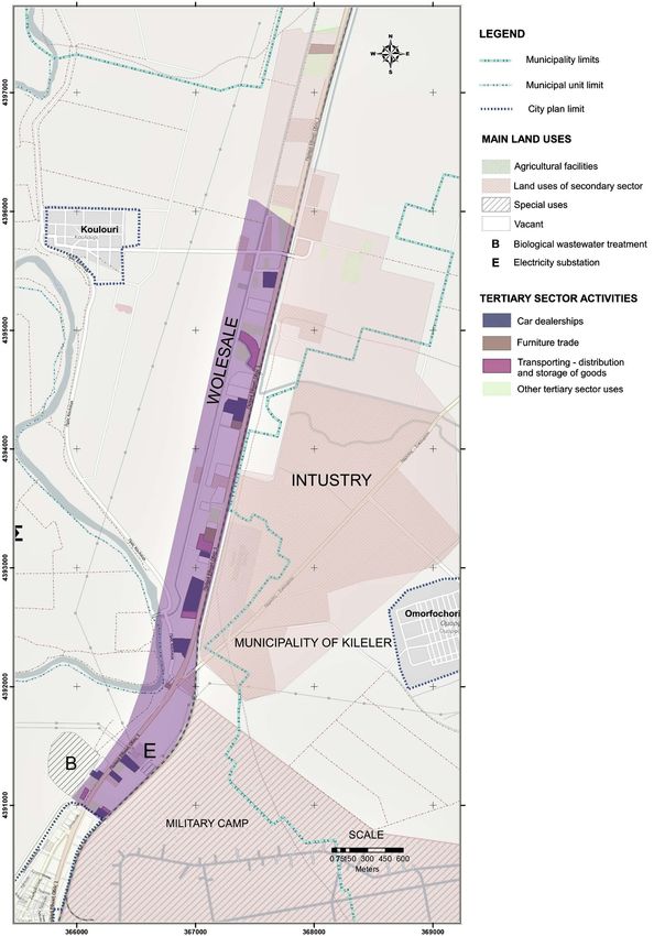
A. Kiakou

                                        specialized and detailed classification of the observed uses in branches of the ter-
                                        tiary sector was made. Thereafter local accumulations of similar uses belonging
                                        to the same branch (the so-called clusters) were identified, aiming to illustrate
                                        the new clusters of consumption and leisure which constitute the central “epi-
                                        centres” of the suburban space.
                                           The above issues are examined through the example of Larissa’s fringes which
                                        follow the radial development pattern as shown in Figure 1.
                                           In this process, important questions are raised: How can the impact of urban
                                        diffusion and penetration in rural areas be captured? What are the main com-
                                        ponents of the landscape of the urban diffusion in terms of land-use patterns and
                                        urban morphology and how could this landscape be classified? What is finally the

        Figure 1. The radial development pattern in Larissa’s fridge belts in 2015. Starting from the east and in a clockwise direc-
        tion: Larissa-Volos Street, the old highway to Athens, Larissa-Farsala Street, Larissa-Karditsa Street, Larissa-Trikala
        Street, Larissa-Kozani Street and finally the old highway to Thessaloniki.

DOI: 10.4236/cus.2021.93037                                    613                                           Current Urban Studies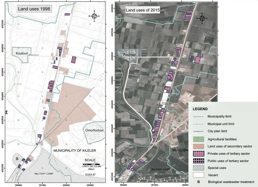
A. Kiakou

                              appropriate, general context of measures to manage random development of the
                              suburban area and create a functional suburb with respect to the natural envi-
                              ronment?

                              2.2. Data Collection—Processing
                              The demand for out of town construction building has been reflected through
                              the evolution of the surface over time and penetration of urban use into the rural
                              area of Larissa peri-urban space for 17 years, that is for the period 1998-2015. To
                              estimate the impact of land uses in each sector of economic activity, land uses
                              have been classified into economic sectors. A first on-the-spot recording of land
                              uses has taken place and geospatial data collection by satellite geo databases dis-
                              cussed below has been made in order to illustrate the types of land use located in
                              the fringes of the examined suburb.
                                 To identify the new types of tertiary sector uses in the suburb, a second more
                              detailed recording of the tertiary sector enterprises has followed during 2011-
                              2014. A pre-concerted group has been searched. In particular, 258 business owners
                              were recorded. The enterprises of the tertiary sector that are located along the
                              zones of motorways (fringe belts) in Larissa’s suburb were recorded. Larissa’s
                              suburb motorways are:
                              • The road to Farsala (Farsalon) and the old highway to Athens, in the south-
                                  ern suburb of the city,
                              • The old highway to Volos (Volou) in the east,
                              • The old highway to Thessaloniki to the north and,
                              • The roads to Karditsa (Karditsis) and Trikala (Trikalon) in the south-western
                                  and western suburbs of the city.
                                 To capture the evolution over time of land uses in the region, material has been
                              gathered from aerial photographs of 12 map sheets of the Hellenic Military Geo-
                              graphical Service (HMGS) taken in1998, from satellite image QuickBird 2008
                              and from Google Earth satellite imagery (taken in 2007, 2010, 2012, 2013 and
                              2015). The very high-definition satellite image QuickBird which was taken on
                              the date July 13, 2008, it has been also used as a background for the mapping of
                              uses located along the zone of roads to Volos, Trikala and Karditsa.
                                 The source of Quick Bird and HMGS images has been the aerial photo library
                              of the laboratory of Rural Area of the Department of Planning and Regional De-
                              velopment (DPRD). The other aerial photographs came from the satellite geo-
                              databases Google Earth and from high-resolution geo-database World Imagery
                              of ESRI which was updated on 17.10.2015.
                                 The satellite imagery of Google Earth, the high-definition satellite image of
                              Quick Bird geo-referenced and the geo-databases of ESRI, OpenStreetMap and
                              Topographic, have been used as backgrounds for land use mapping in 2015.
                              Twelve (12) HMGS map sheets taken in 1998, geo-referenced and joined in or-
                              der to cover the area of the region under study, and have been used for mapping
                              referred to in 1998.

DOI: 10.4236/cus.2021.93037                        614                                      Current Urban Studies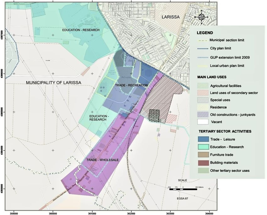
A. Kiakou

                              2.3. Land Use Classification
                              In Greece land use classification has been based on Presidential Decree (P.D.) of
                              6.3.1987, until recently. It was the official land use classification system, used by
                              the various types of urban and spatial plans. Since June 29, 2018, the date when
                              P.D. No. 59/21.06.2018 is established, new categories of land use have been fore-
                              seen. The research which had been conducted before the new P.D. No. 59/
                              21.06.2018 and its subsequent amendments was adopted in 2018, has been based
                              partly on the P.D. of 6.3.1987 which was formed to implement urban planning,
                              and partly on other regulation mentioned bellow. Consequently, its implementa-
                              tion which should have already been specialized thirty years ago since its intro-
                              duction has not been easy, because nowadays its true interpretation is impossi-
                              ble.
                                 For the above reasons all the relevant regulations have been used, and the re-
                              levant categories of uses have been adjusted to the needs of the research. How-
                              ever, subsequently the classification was significantly diversified due to the par-
                              ticularity of the suburban construction building. Due to the different character
                              of the out of town building (more dispersed construction) than the inner-city
                              construction, most categories of uses are limited. Finally, 16 categories of uses
                              have been formed and the appropriate regulation is referred for each category in
                              Table 1.
                                 Attempting to describe the evolution of land use on the main sectors of eco-
                              nomic activity, a general classification followed. The above land use categories
                              were grouped together in land uses sectors of economic activity. In this classifi-
                              cation, urban uses—installations and not crops (agricultural land) were included.
                              So, the following 7 general categories were formed:
                                 1) Agricultural and livestock facilities category including: greenhouses and
                              agricultural warehouses;
                                 2) Uses of secondary sector category including: crafts-industry, garages-ma-
                              chining, PPC substations;
                                 3) Tertiary sector uses category including: shopping mall, shopping park, re-
                              tail, residence—fuel station, wholesale, care (clinics, hospitals, boarding school,
                              remediation unit and general health services), Education (primary, secondary
                              and tertiary), recreation, culture, sports, logistics-transport companies, ware-
                              houses, Vehicle Technical Control Center, bus station. This category was divided
                              into two subcategories: public and private uses of tertiary sector, because many
                              of the establishments of specialized use (education, health, culture) belong to the
                              government;
                                 4) Residence category: residences included;
                                 5) Special uses category: in this category included utilities such as installations
                              of the Municipal Enterprise for Water Supply and Sewerage (water tanks), bio-
                              logical wastewater treatment, cemetery and camp;
                                 6) Old constructions– Stockyards category; and
                                 7) Vacant construction category.

DOI: 10.4236/cus.2021.93037                        615                                        Current Urban Studies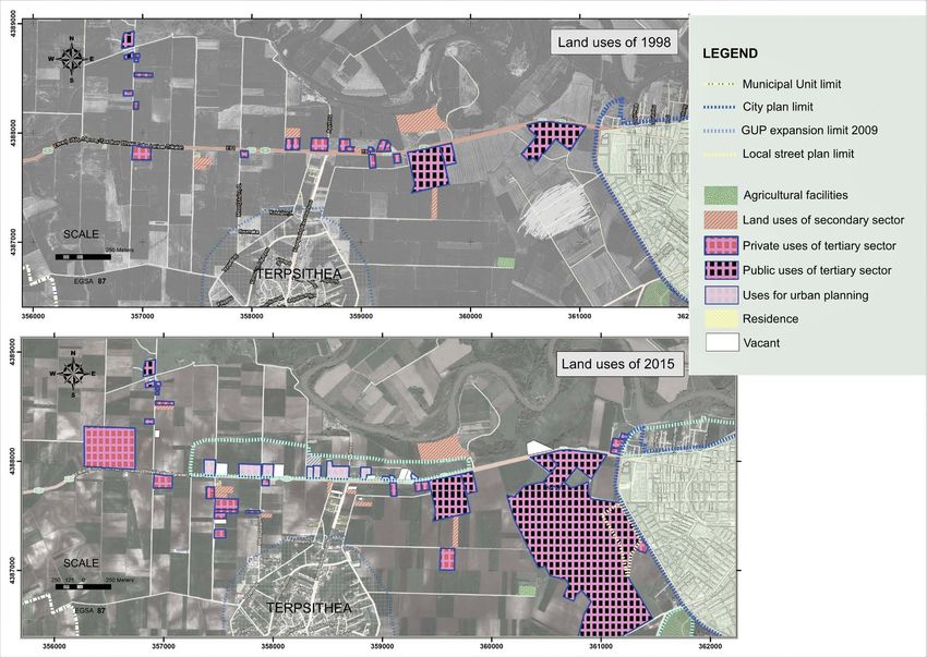
A. Kiakou

Table 1. Land uses classification.

s/n Category                   Land uses                                                Regulation

1   Residence                  Residence                                                P. D. 23.6-6.3.1987 (Ministry of Environment, Spatial
                                                                                        Planning and Public Works, 1987)

2   Fuel station               Mixed use of fuel station, residence                     P. D. 23.6-6.3.1987, P. D. 81/80 (GG 27/Α/29.1.80)
                                                                                        (Ministry of Public Works, 1980)

3   Polycentre                 Commercial stores, multiplex cinema, cafes,              The suburban polycentres under study
                               restaurants, playroom, playground, hypermarkets

4   Trade                      Retail stores, supermarkets, Furniture exhibition        Article 5 P.D. of 24-31.5.1985 (Ministry of Spatial
                                                                                        Planning, Settlement and Environment, 1985)
                                                                                        Trade exhibitions category of the P. D. 23.6-6.3.1987

5   Wholesale                  Wholesale Trade Enterprises                              Article 7 P.D. 23.6-6.3.1987

6   Healthcare                 Hospitals, clinics, therapeutic units                    Article 6 of P.D. 6/17.10.1978 (Ministry of Public
                                                                                        Works, 1978)

7   Education                  Infrastructure of Primary, secondary, tertiary education Article 5 of P.D. 6/17.10.1978

8   Leisure Sports             Night clubs, Restaurants, Audience Areas Sports          P.D. 23.6-6.3.1987
                               facilities, open Stadiums, sport                         Article 9 of Presidential Decree 6/17.10.1978

9   Logistics—Transport        Cargo handling companies, freight forwarding             Use category under study
    Companies                  companies, logistics

10 Crafts-Industry             Industrial installations, crafts, Garages-Workshop       Article 4 of P.D. 24/31.5.1985

11 Old                         Vehicle storage fields old constructions
   Constructions-Stockyards

12 Agricultural use            Agricultural-food buildings, greenhouses                 Article 2 P.D. 24-31.5.1985

13 Warehouses                  Commercial warehouses, agricultural warehouses           Article 9 P.D. 2431.5.1985

14 Vehicle Technical Control                                                            Article 16 P.D. /6.10.78 (GG 538/D/17.10.78
   Center

15 Public Power Corporation    Wider category of “public utilities” PPC -OTE-water      Article 7 P.D. uses 24-31.5.1985, Article 14 P.D.
   (PPC) Substation            supply                                                   6.10.78 (GG 538/D/17.10.78)

16 Vacants                     Vacant, abandoned buildings                              Use category under study

                                              In order to identify the new “epicentres”, an attempt to analyze the branches
                                           of the prevailing sector in the fringe belts was made in combination with the
                                           formation of spatial accumulations (clusters) of the suburb and the illustration
                                           of the epicentres resulted. To be specific, the tertiary sector uses observed from
                                           the on-site recording were classified in spatial accumulations of similar branches,
                                           that are the epicentres. Thus, 7 categories of similar uses were created. The above
                                           clusters are presented in detail in the section: The Creation of “new centralities”.

                                           3. Results and Discussion
                                           The historical development of Larissa has created a traditional dispersion of land
                                           uses. In recent years large chains of shops have opened branches or have been
                                           developed partnerships (franchise), while department stores of regional range
                                           (Praktiker, Carrefour, Makro, Jumbo, Smart Outlet, etc.) have been installed.
                                           Such department stores follow a completely different model of location from the

DOI: 10.4236/cus.2021.93037                                            616                                               Current Urban Studies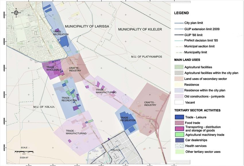
A. Kiakou

                              shops downtown. Due to their special needs (large parking spaces, storage areas,
                              extensive facilities) and land costs, they have been installed around the city, in
                              the southwestern districts in out-off-plan areas, such as the peripheral road to
                              Trikala, the road to Volos, the old highway to Athens, and the highway to Koza-
                              ni (Municipality of Larissa, 2008).
                                 Recently, following the new standards of suburban Polycentres, there is a de-
                              velopment of such mixed-use facilities. The concerned Polycentres are a typical
                              case of activities relocation (Delocalization) in areas with a higher land supply
                              (and lower land costs), through the diffusion process of central uses and subse-
                              quently the creation of new centres.
                                 As is the case with the commercial transformations of metropolitan areas, land
                              use is linked to traffic or is located in proximity to transport interchanges. In the
                              suburb under study, it is observed the location and creation of polycentres like
                              Pantheon Plaza in the southern edge of the city near the old highway to Athens, the
                              polycentre “Thessaly” (ex-Carrefour-Ster Cinemas) at the 1st km of road to Kozani
                              and just before the entrance to the settlement of Giannouli and the new polycentre
                              “Larissa”, known as Larissa Retail Park located near the Nikaia junction.
                                 These trends of suburbanization and creation of out of town central urban uses
                              create long-term changes in the suburban landscape. A detailed analysis of these
                              developments in each axis of development (fringe belt) follows in the subsequent
                              sections.

                              3.1. South Axes Larissa—Athens (Nikaia Junction) and Larissa—
                                   Farsala
                              The area is central and attracts economic activities of interregional range. A typical
                              example of this trend is the department stores that have been created from 2009
                              and today constitute the new Polycentre, Retail Park “Larisa”. In the area under
                              research prevail commercial uses and hypermarkets (Praktiker, Vassilopoulos).
                              Wholesale activities, schools, leisure and sports facilities are also observed. Activi-
                              ties of secondary sector, large industrial units (Biokarpet, Karatzis A.E., Lariplast)
                              and factories of national range (Melissa, La Vitherm etc.) are also concentrated.
                                 According to the general classification of land uses in the main sectors of
                              economic activity and the land area evolution of each use category (in sqm), the
                              rapid increase of 169.17% of the surface of tertiary activities is evident in the
                              zone under research (Table 2). Positive change was becoming throughout the
                              period 1998-2015. This positive change was mainly due to the creation of the
                              polycentres of Larissa and the ex-Pantheon Plaza (current Fashion City Outlet)
                              in the area of road Larissa-Athens and some commercial uses in the southern
                              part of the zone of the road to Farsala (Figure 2).
                                 The presence of the residence was also important, and it was already develop-
                              ing (8.29%) in the suburban area of Nikaia during the period 1998-2015, as well
                              as in the area around Pantheon Plaza shopping mall where it was a dominant use
                              since 1998. Part of the surface of this use was incorporated into the city plan

DOI: 10.4236/cus.2021.93037                         617                                        Current Urban Studies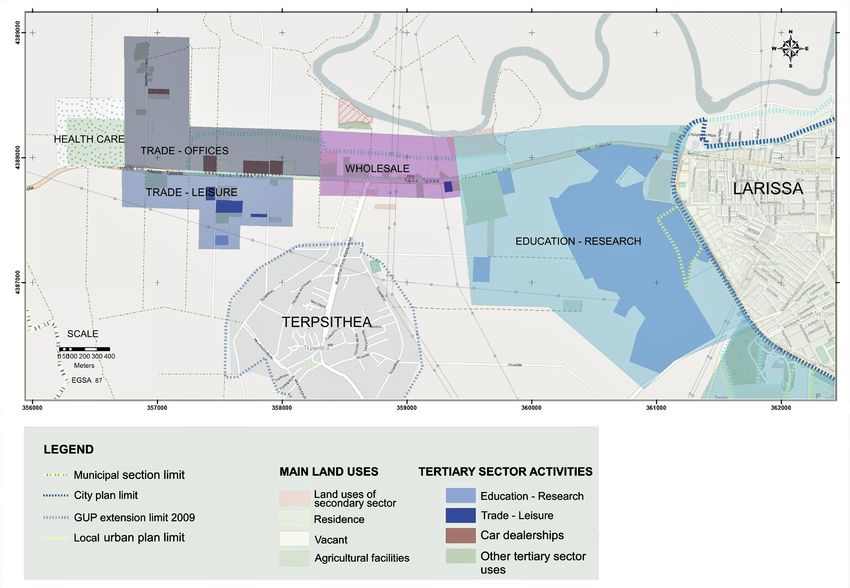
A. Kiakou

Table 2. Land area distribution (sqm) and percentage change per sector of economic activity in the zones extending along the
roads Larissa-Farsala and Larissa-Athens.

                                                                                          Area                         % Change
                           LAND USES
                                                                              1998                  2015              1998-2015

                       Agricultural facilities                              25,488.48             25,116.38              −1.46

                      Secondary sector uses                                521,046.97            673,801.14              29.32

                       Tertiary sector uses                                417,137.93            1,122,803.09           169.17

                             Residence                                     342,909.93            319,928.14              −6.70

 Residence included in city plan by the General Urban Plan of 2009              −                 51,423.55               −

                          Total residence                                  342,909.93            371,351.69              8.29

                  Old constructions-Stockyards                              52,509.49             74,559.82              41.99

                              Vacants                                        4712.09             121,365.04             2475.61

                               Total                                       1,377,271.12           2,349,174              70.57

Figure 2. Land uses by sector of activity in the zones extending along the roads to Athens and Farsala in the years 1998 and 2015.

                                                 after it had been expanded in 2009.
                                                    There was a significant increase in the vacant commercial properties created
                                                 during the period 2009-2012, as well as old constructions and stockyards (41.99%).

DOI: 10.4236/cus.2021.93037                                          618                                        Current Urban Studies
A. Kiakou
The secondary sector had significant growth (29.32%) but mainly carried out
during the period 1998-2007, as during the period 2007-2015 a relative stagna-
tion took place.
3.2. Larissa-Karditsa Axis
At the beginning of this axis (Provincial Road 28), activities of education, health
and sport, located in large properties of public sector, operate (Department of
Medicine, University Hospital, FC Arena etc). Following the above uses, private in-
vestments are developed mainly in the building materials field, furniture and agri-
cultural products branches as far as the 7th km. Most of these uses were included in
the urban plan extension area of Larissa General Urban Plan in 2009 (Figure 3).
According to the rate of change of uses per economy sector in this region, as
shown in Table 3, significant growth was noted from 1998 to 2015 in housing
(29.44%), in private and public sector investments which almost doubled (96.12%
and 62.66% respectively), while after the inclusion of these activities in the urban
plan area, their positive change diminished technically (23.25% and 56.08% re-
spectively). At the same time, the area shows new special uses (water supply fa-
cilities, cemetery) in a land of former military use, resulting in the increase
Figure 3. Land uses by sector of activity in the zones extending along the road to Karditsa in the years 1998 and 2015.
DOI: 10.4236/cus.2021.93037 619 Current Urban StudiesA. Kiakou
Table 3. Land area distribution (sqm) and percentage change per sector of economic ac-
tivity in the zone extending along the road Larissa-Karditsa.
Area % Change
LAND USES
1998 2015 1998-2015
Agricultural facilities 12,468 21,630.34 73.49
Secondary sector uses before acceding in an urban plan area 56,649.97 72,490.26 27.96
Secondary sector uses after acceding in an urban plan area 56,649.97 62,993.15 11.20
Tertiary sector uses before acceding in an urban plan area
Private uses of Tertiary sector 185.934 364.653.5 96.12
Public uses of Tertiary sector 226,876.79 369,027.85 62.66
Tertiary sector uses after acceding in an urban plan area
Private uses of Tertiary sector 185,934.02 229,157.67 23.25
Public uses of Tertiary sector 226,876.79 354,119.93 56.08
Special uses in an urban plan area 0 (715,983) -
Residence before acceding in an urban plan area 29,344.44 60,218.53 105.21
Residence after acceding in an urban plan area 29,344.44 37,983.20 29.44
Old constructions before acceding in an urban plan area 31,179.80 31,856.59 2.17
Old constructions after acceding in an urban plan area 31,179.80 12,110.57 -61.16
Vacant before acceding in an urban plan area 0.00 26,641.08 -
Vacant after acceding in an urban plan area 0.00 12,394.02 -
Total Land use before acceding in an urban plan area 542,453.02 1,684,131.51 210.47
Total Land use after acceding in an urban plan area 542,453.02 1,446,371.88 166.64
of the surface of the special uses in sqm.
3.3. Larissa-Trikala Axis
In the western districts, at the city periphery on the road to Trikala and on its
outer ring road, significant public investments are developing in the fields of re-
search and education (Departments of Technological Educational Institute, Ave-
rofeios School, etc.). The above uses together with the private schools operating
in the area (Bakogianni S.A. schools) form an integrated complex of uses of pri-
mary, secondary and tertiary education which could constitute a single epicentre
of the suburb including education and research uses (Figure 4).
This classification is described in detail in the following section: The Creation
of “New Centralities”. In the continuation of these activities, private investments
are developing mainly operating in the automotive trade.
Regarding the evolution of the studied uses over time, according to Table 4,
there is significant growth in private commercial investments (302.32%) and the
surface they occupy is more than doubled from 1998 to 2015. In total, the area
occupied by investments of the tertiary sector shows an increase of 727%.
DOI: 10.4236/cus.2021.93037 620 Current Urban StudiesA. Kiakou
Figure 4. Land uses by sector of activity in the zones extending along road to Trikala in the years 1998 and 2015.
Table 4. Land area distribution (sqm) and percentage change per sector of economic ac-
tivity in the zone extending along the road Larissa-Trikala.
Area % Change
LAND USES
1998 2015 1998-2015
Agricultural facilities 12,930.13 12,930.13 0.00
Secondary sector uses before acceding in an urban plan area 117,492.04 142,312.33 21.13
Secondary sector uses after acceding in an urban plan area 117,492.04 128,369.74 9.26
Tertiary sector uses before acceding in an urban plan area
Private uses of Tertiary sector 109,844.07 441,926.21 302.32
Public uses of Tertiary sector 264,255.86 1,387,018.167 424.88
Tertiary sector uses after acceding in an urban plan area
Private uses of Tertiary sector 109,844.07 336,342.70 206.20
Public uses of Tertiary sector 264,255.86 1,387,018.167 424.88
Residence 7121.69 19,032.78 167.25
Vacants 0.00 71,183.20 -
Total Land use before acceding in an urban plan area 511,643.79 2,074,402.81 305.44
Total Land use after acceding in an urban plan area 511,643.79 1,954,876.71 282.08
DOI: 10.4236/cus.2021.93037 621 Current Urban StudiesA. Kiakou
With the integration of many uses of the private sector in the urban plan according
to the proposal of the urban plan extension of the approved General Urban Plan of
Larissa (2009), the above percentage declined a little (631.08%), while the tertiary
sector continues to occupy a significant proportion in the land-uses of the region.
Significant growth of 167% is also noted in the residence due to the develop-
ment of the Terpsithea settlement, although it is not significantly involved in the
percentage composition of the land use surface. On the contrary, the productive
activities of the secondary sector have the smallest growth on their surface (21.13%)
before joining the urban plan area).
3.4. Larissa-Volos Axis
Along the zone of the road to Volos, commercial development is linked to the
traditional industry (furniture, automobile, clothing, and professional equipment).
The last one is developing in real estate located some meters behind the old
highway to Volos, as shown in Figure 5. The commercial stores are located mainly
Figure 5. Land uses by sector of activity in the zone extending along the road to Volos in the years 1998 and 2015.
DOI: 10.4236/cus.2021.93037 622 Current Urban StudiesA. Kiakou
in real estate near Larissa-Volos axis and they are connected to the road through
byways or connections. Retail and wholesale of cars, storage and transfer of prod-
ucts and foodstuffs prevail.
In terms of the development of land uses in this region, according to Table 5,
it is observed that tertiary and secondary sector activities are increasing by 38%
and 33.54% respectively, while the residence surface falls by 40.65%. With the
technical reduction created by the extension of the city plan with the creation of
an urban planning area as reception area of wholesale uses, the increase in ter-
tiary sector uses is much smaller than before acceding in the urban plan area
(7.68%), but it doesn’t correspond to the real development trend of the region.
3.5. Larissa-Thessaloniki Axis
In the northern zone of the old highway to Thessaloniki, the traditional industry
prevails. From the exit of the city, as far as the first two kilometres, no significant
construction is observed, because of the large public areas of the camp, of the
forest park and the PPC high voltage substation. In the area the special uses
mentioned above, along with the extent of the railroad and PPC, create discon-
tinuities in urban diffusion of the city.
The development is noted after the Sykourio junction and is distinguished
between two different production sectors. In the eastern zone that develops along
the eastern edge of the old highway to Thessaloniki, industrial and craft-based
traditional units are concentrated, the area is an informal industrial zone of the
Table 5. Land area distribution (sqm) and percentage change per sector of economic ac-
tivity in the zone extending along the road Larissa-Volos.
Area % Change
LAND USES
1998 2015 1998-2015
Agricultural facilities before acceding in an urban plan area 17,901.09 17,901.09 0.00
Agricultural facilities after acceding in an urban plan area 17,901.09 8716.94 −51.30
Secondary sector uses before acceding in an urban plan area 377,650.93 504,313.57 33.54
Secondary sector uses after acceding in an urban plan area 377,650.93 418,373.66 10.78
Tertiary sector uses before acceding in an urban plan area 232,730.17 321,326.09 38.07
Tertiary sector uses after acceding in an urban plan area 232,730.17 250,599.83 7.68
Residence before acceding in an urban plan area 46,658.72 41,574.78 −10.90
Residence after acceding in an urban plan area 46,658.72 27,692.27 −40.65
Old constructions before acceding in an urban plan area 58,051.85 77,613.22 33.70
Old constructions after acceding in an urban plan area 58,051.85 40,635.06 −30.00
Vacant before acceding in an urban plan area 834.69 114,833.54 13,657.63
Vacant after acceding in an urban plan area 834.69 105,457.67 12,534.35
Total Land use before acceding in an urban plan area 733,827.45 1,077,562.29 46.84
Total Land use after acceding in an urban plan area 733,827.45 851,475.43 16.03
DOI: 10.4236/cus.2021.93037 623 Current Urban StudiesA. Kiakou
city and west, commercial stores of the automobile sector, car agents, spare
parts—tires and transporting as well as units of products storage are located
(Figure 6).
According to the development over time of land uses of the region, as shown
in Table 6, only the tertiary sector activities were developed by 30.23% during
the period 1998-2015. The uses of the secondary sector, even though they occupy
Figure 6. Land uses by sector of activity in the zone extending along the road to Thessaloniki in the years 1998 and 2015.
Table 6. Land area distribution (sqm) and percentage change per sector of economic ac-
tivity in the zone extending along the road Larissa-Thessaloniki.
Area % Change
LAND USES
1998 2015 1998-2015
Agricultural facilities 2834 2834 0.00
Secondary sector uses 3,443,204 3,371,211 -2.09
Tertiary sector uses 325,691 424,154 30.23
Special uses 9,883,274 9,521,336 -3.66
Vacant 0 182,430 -
Total 13,655,004 13,501,965 -1.12
DOI: 10.4236/cus.2021.93037 624 Current Urban StudiesA. Kiakou
a significant area, didn’t progress (−2%).
3.6. The Creation of “New Centralities”
To classify the urban landscape of the examined suburb and to identify the new
clusters of consumption and leisure which constitute the central “epicentres”, an
attempt to analyze the prevailing branches of the tertiary sector which is the
most developed sector in the studied fringe belts, was made. Also, local accumu-
lations of similar branches’ land use were identified in order to shape the spatial
distribution of the suburban epicenters.
In a specialized classification, the uses of the tertiary sector were divided into
clusters of similar commercial branches or other smaller sub-categories all be-
longing to the tertiary sector as they appear according to a questionnaire survey
(Kiakou, 2017) and according to the on-the-spot recording of activities. Of the
total of 141 enterprise owners of the region which responded to a related ques-
tion, a number of 107 are active in retail and wholesale trade, of which 17 are in
the production and sale of their product, 3 provide products and services and 34
are service providers. In Table 7 below, the branches of the tertiary sector of the
research area with the largest concentration of units are presented.
According to Figure 7, it is observed that the largest development, in number
of units, have leisure, car sector, transporting-logistics of goods and furniture.
Larissa-Farsala axis is specialized in agricultural machinery, Larissa-Athens axis
in leisure uses, Larissa-Thessaloniki axis in car branch, Larissa-Karditsa axis in
furniture and building materials and Larissa-Trikala axis in cars and education
& research branches.
The created epicentres include mixed and different combinations of land use’
categories from the tertiary sector branches coming from its detailed classifica-
tion and units coming from the secondary sector according to the general land
use classification preceding in the Methodology section. Spatial accumulation of
Table 7. Activities with the largest number of units on the development, out of town axes examined.
Number of units
Land use/Branch Larissa- Larissa- Larissa- Larissa- Larissa- Larissa-
Total
Farsala axis Athens axis Volos axis Thessalo-niki axis Karditsa axis Trikala axis
Agricultural machinery-products 7 - 3 - 3 2 15
Food 6 2 6 1 1 1 17
Transporting-distribution and storage of
6 7 5 5 1 - 24
goods
Cars-spare parts-tires 2 2 8 11 1 5 29
Building materials - - 5 1 10 2 18
Furniture 1 - 4 5 10 4 24
Leisure uses 5 14 1 - 7 4 17
Education-Research 3 - 1 1 4 7 16
DOI: 10.4236/cus.2021.93037 625 Current Urban StudiesA. Kiakou
Figure 7. Activities with the largest number of units on the out-of-town axes under examination.
these uses forms the pursued epicentres classified into the following 7 categories:
• Trade-recreation epicentres. They predominate land uses of leisure, sport
(sports, restaurants, night clubs, football centers combined with cafés and
play areas) and the new polycentres developed along the major road axis which
are analyzed above.
• Crafts-industry. It includes purely manufacturers, industrial installations, la-
boratories, Garages-Workshops.
• Trade-manufacturing epicentres. They include at approximately the same
number of secondary production units and commercial stores.
• Trade-wholesale epicentres. They include wholesale and trade shops of vari-
ous branches.
• Wholesale-recreation epicentres. They include wholesale and recreation shops.
• Trade-offices epicentres. They include commercial shops, private services of-
fices and public services offices.
• Epicentres of education-research. They include either exclusively units of
public and private education, or care units in combination with higher edu-
cation (University Hospital-Medical school).
It is observed that, of the 7 categories of epicentres, 4 are oriented in purely con-
sumption, trade and recreation uses: Trade-recreation epicentres, Trade-whole-
sale epicentres, Wholesale-recreation epicentres, Trade-offices epicentres and:
Education-research epicenters. The created epicentres are illustrated in the fol-
lowing Figures 8-12.
Νevertheless, the “epicentres” which are developed in the region, because of
the lack of an urban character and the small scale, are smaller in number and
density of uses, in relation to the new urban activities of metropolitan centres,
e.g. Athens, Barcelona, Singapore, UK cities, USA etc. (Gospodini, 2006; Hutton,
2000) and they have local urban plans as autogenous uses, but they are un-connected
DOI: 10.4236/cus.2021.93037 626 Current Urban StudiesA. Kiakou
Figure 8. New suburban epicentres in the zones extending along the road to Athens and Farsala.
among each other.
The development of theses clusters has been left to private initiative, which in
contrast to the innovative planning of such epicentres in European cities and the
suburbs of the third generation in the USA that are competitive and urban orga-
nized (Tachieva, 2011), they produce an indifferent landscape that leads to the
exhaustion of the natural environment (Gospodini, 2007).
4. Recommendations
Observing the historical development of Larissa until the modern post-industrial
developments in the fringe belts, the need to organize the produced suburb is
created. According to the development trends of the city in terms of land use
and population, it is proposed to create special, reception areas which would be
installed near the main roads and junctions with whom they would have well
connection or/and include the “epicentres” of the area, but not in a random way,
as they would be intended and planned to welcome the new modern develop-
ments.
The main goal of the project is the transformation of the suburb from a space
of random dispersed and unorganized land uses, into a planned suburban area,
ensuring the functional development of the suburb and the preservation of the
DOI: 10.4236/cus.2021.93037 627 Current Urban StudiesA. Kiakou
Figure 9. New suburban epicentres in the zone extending along the road to Karditsa.
natural environment.
In the Regional Framework for Spatial Planning and Sustainable Development
(RFSPSD) of the region of Thessaly (Ministry of Environment, Planning and
Public Works, 2003), the creation of new, properly designed reception areas of
central activities, constitute one of the main directions of the planning. Accord-
ing to the General Urban Plan of Larissa, it has been estimated that the size
of organized reception areas must be 1000 - 2000 acres at the prefecture-level
(Tsakiris & Lalenis, 2009). According to the population forecast for the target
year 2025, the trends of uses and urban planning standards, the required areas of
central activities reception are calculated, in total, for a time horizon until 2025,
equal to 3038 acres (Kiakou, 2017).
It is advisable, however, to examine a location within the municipality, be-
cause, on the one hand, there are categories of units that need more direct spatial
contact with the main city (either due to their small size or due to decisive de-
pendence on the local market) and on the other hand, this has a reducing effect
DOI: 10.4236/cus.2021.93037 628 Current Urban StudiesA. Kiakou
Figure 10. New suburban epicentres in the zone extending along the road to Trikala.
in traffic loads, fuel consumption and the production of gaseous pollutants (Tsa-
kiris & Lalenis, 2009). Τhe availability of space (suitable areas in terms of geo-
morphology, existing uses and positions in the overall spatial organization) are
important factors in the location selection (Tsakiris & Lalenis, 2009).
The above factors, as well as the following ones, must be taken into account
for the location selection of the reception areas:
• Demand trends for the development of modern activities, as analyzed in the
land uses survey.
• The existing infrastructure and the facilities of the suburban area.
• The location of the reception areas in relation to the existing transport and
connections network.
• The accessibility to transport infrastructure networks to ensure market access.
• The Special protection areas (ex. Natura 2000).
The areas with the largest development of new activities as it results from
the above land uses analysis is the suburban areas extending along the roads to
Trikala and Athens. These areas, as shown in the analysis of a special survey
conducted on business owners, give a high score in the location of their activity in
relation to other cities, the road network and road connections (Biocarpet junc-
tion, Nikaia junction, Trikala ring road) that ensure access to these markets
DOI: 10.4236/cus.2021.93037 629 Current Urban StudiesA. Kiakou
Figure 11. New suburban epicentres in the zone extending along the road to Volos.
(Kiakou, 2017). These areas, also show the highest growth of land values in real
estate with view adjacent to the main road (Kiakou, 2017).
In addition to the main reasons for installation in the out-of-plan area, which
is the initially low land acquisition price and the supply of land, the area of Tri-
kala Street is chosen by investors according to the questionnaire survey (Kiakou,
2017), because of the demand for the development of tertiary activities, the rural
environment and the location in relation to the other cities. It is also an area that
has an already developed infrastructure in significant public uses along the ring
road zone, the so-called education-research epicentre presented above, and could
welcome additional uses of the research and education sector that would be op-
erating together with the existing ones.
Volos street area follows the ranking, showing comparatively smaller growth
(positive change) in the surface of tertiary sector land uses in relation to the
areas of roads to Athens and Trikala, however, this zone is a choice with a high
score by business owners because of the location of the property in relation to
the main roads (Kiakou, 2017). The area of Volos Street is connected to the main
and to the secondary road network with appropriate infrastructure (connections,
side streets, Agia junction).
The area of Volos Street has a long-term perspective to further improve its
DOI: 10.4236/cus.2021.93037 630 Current Urban StudiesA. Kiakou
Figure 12. New suburban epicentres in the zone extending along the road to Thessaloniki.
DOI: 10.4236/cus.2021.93037 631 Current Urban StudiesA. Kiakou
accessibility to the markets and its connectivity with other road networks. The
most important is the existence of a connection between Larissa-Volos dipole,
which presents a significant dynamic in the development of activities of interre-
gional range (Metaxas & Kallioras, 2007).
5. Conclusion and Discussion
The historical development of Larissa has created a traditional dispersion of land
uses, followed by the modern post-industrial developments in the fringe belts of
the city. The surface of urban, out-of-town land uses along the fringe belts of La-
rissa’s suburb during the period 1998-2015, shows significant growth and pene-
tration in rural areas. This development documents the demand’s increase for
out of town construction buildings especially oriented towards tertiary sector ac-
tivities such as trade, entertainment and wholesale.
This is evident by the rapid increase in the surface of tertiary sector activities
during the examined period. Land supply and its development with the con-
struction of stores show significant growth over the period 1998-2007 and con-
tinue to develop until 2015 despite the significant increase in the vacant com-
mercial properties created during the period 2009-2012 that signals the impact
of economic recession on the real estate market. Finally, secondary sector activi-
ties present stagnation, even though they occupy a significant surface of the ob-
served suburb.
In the southern and western areas of the examined suburb (Larissa-Athens,
Larissa-Farsala axes), a significant positive change was noted in the surface of
tertiary sector activities throughout the period 1998-2015. This positive change
was mainly due to the creation of polycentres, leisure and commercial activities
of interregional range.
In the western districts, at the city periphery on zones of the roads to Karditsa
and Trikala and its outer ring road, significant public and private investments
have been developed in the fields of research and education and health. The
above uses along with the private schools which could operate in an integrated
complex of uses of primary, secondary and tertiary education, could constitute a
single epicentre of the suburb.
Regarding the private investments of the suburb, development trends of au-
tomotive industries, logistics, retail, entertainment and furniture are observed.
Also, the public sector contribution to the fields of education, health and research
is important. The car sector, transportation-logistics of goods and furniture con-
centrate the largest number of units, but in some areas and particularly in the
western and southern suburbs the uses of education and leisure fields present the
largest development in terms of the land surface.
Regarding the morphology of the suburban landscape, although the linear de-
velopment model dominates as a consequence of the attraction of the road in-
frastructure, at the same time it’s also observed the type B of “diffused urbanity”
(Gospodini, 2006) without following always the radial development pattern. So,
DOI: 10.4236/cus.2021.93037 632 Current Urban StudiesA. Kiakou
Larissa would be said to be broadly approaching the radial model but in combi-
nation with the polycentric model, which is expressed unplanned not in a regu-
lar way, through type B of epicentres of “diffused urbanity”.
There are clusters of similar uses of the so-called “new centralities” or “epi-
centres” on the fringe belts of the city and also, there are accumulations of the
new central activities located peripherally in the peri-urban zone of the city, as in
the case of uses near the Trikala ring road where the epicentres of education and
research prevail. Nevertheless, in any case, land use development follows always
the proximity to road infrastructure.
Analyzing the prevailing branches of the tertiary sector according to their spa-
tial distribution, the new “epicentres” of central land uses of the suburban space
are formed. Totally, 7 categories of epicentres were identified, of which 4 is oriented
in purely consumption and trade uses: Trade-recreation epicentres, Trade-whole-
sale epicentres, Wholesale-recreation epicentres, Trade & offices epicentres and
Education & research epicentres that include special uses of education and re-
search.
However, the epicentres of the region don’t have an urban character, they in-
clude a small number of dispersed uses which are urban unplanned and uncon-
nected among each other. All the above-mentioned developments, create an
indifferent landscape leading to the exhaustion of natural environment. Conse-
quently, the need to organize the suburb in the fringe belts of the city is created.
According to the advantages of each region of development in the suburb un-
der study, two candidates wider regions resulted, in order to install the planned
areas for the reception of new developments:
a) The area of Trikala Street, which is chosen because of the demand for the
development of tertiary activities, the rural environment the location in relation
to the other cities but also, the already existing developed infrastructure in sig-
nificant public uses along the ring road zone, the so-called Education-research
epicentre, and
b) Volos street area which although follows the ranking, showing compara-
tively smaller growth in the surface of tertiary sector land uses in relation to the
areas along the roads to Athens and Trikala, it has a long-term perspective to
further improve its accessibility to the markets and its connectivity with other
road networks. But, the most important is the existence of a connection between
Larissa-Volos dipole that attracts activities of interregional range.
Regarding the limitations of the research, there are geographical constraints,
restrictions concerning the characteristics of the area where enterprises devel-
oping and the type of economic activity as well as restrictions related to the cur-
rent legislative framework.
At the spatial level, this paper analyses the suburban patterns in terms of land
uses and morphology of a Mediterranean medium-sized city of the mainland.
The wider research, in order to deal with phenomena of anarchic urbanization,
may deal with different sectors of economic activity and urban areas of different
DOI: 10.4236/cus.2021.93037 633 Current Urban StudiesA. Kiakou
morphology and development patterns such as coastal zones, tourist areas, areas
with high population and economic concentration or large metropolitan centres.
In terms of geography, therefore, each case is different and the research should
be adapted to the particular spatial and morphological data of each area. Thus,
data collection must be differentiated and oriented to these economic sectors and
areas presenting trends of development (e.g. tourist units of a coastal zone) or
must take into account specific limitations (e.g. protection zones, etc.). Except
for natural and geographical particularities, generally, land uses development is
connected to the transport networks and most of the time, road networks.
Additionally, the categorization and classification of land uses differs depending
on the sample size, that is the number of activities presented, the type of economic
activity, and the characteristics of the area where enterprises developing during
the detailed recording. For example, within a metropolitan city, clusters of simi-
lar uses have a more cohesive character due to the character of the inner tissue of
the city, in contrast to the suburb of a medium-sized city, such as the suburb of
Larissa, where the areas of activities lack an urban plan and activities are sparsely
structured. In summary, this research is limited mostly to the classification and
management of randomly growing uses in the suburbs.
Land use classification also differs due to the different legislative framework of
each country. Each country has different regulations for the categories and clas-
sification of activities. In addition, the classification of uses must take into account
the specific uses observed in each region and whether these special uses are pro-
vided by the legislation of each country or not. For example, in Greece, “poly-
centres” were not provided for in the old presidential decree.
Therefore, in the context of creation of a master plan or of a policy in order to
manage urbanization, the above restrictions must be taken into account. As far
as the factors mentioned in the Recommendations section, for determination of
the new land uses reception area location, most of these factors can be genera-
lized in order to create a policy that directs the demand for construction. How-
ever, in some cases, like in Greece, most of the time, planning follow trends and
in that case, the demand for the development depends on trends of development
of each region and its location in relation to the city (inner tissue of the city, city’s
periphery or out-of-city plan area) and the connections (road or other networks)
with the city and the other cities and markets.
Conflicts of Interest
The author declares no conflicts of interest regarding the publication of this paper.
References
Foot, J. (2000). The Urban Periphery, Myth and Reality: Milan 1950-2000. City, 4, 7-26.
https://doi.org/10.1080/713656994
Gospodini, A. (2006). Portraying, Classifying and Understanding the Emerging Land-
scapes in the Post-Industrial City. Cities, 23, 311-330.
DOI: 10.4236/cus.2021.93037 634 Current Urban StudiesYou can also read