The 1936 Italian Kingdom Forest Map reviewed: a dataset for landscape and ecological research - IRIS Univ ...
←
→
Page content transcription
If your browser does not render page correctly, please read the page content below
Annals of Silvicultural Research
                                                              42 (1), 2018: 3-19

                                               https://journals-crea.4science.it/index.php/asr

Research paper

The 1936 Italian Kingdom Forest Map reviewed: a dataset for landscape
and ecological research
Fabrizio Ferretti1*, Chiara Sboarina1, Clara Tattoni2, Alfonso Vitti2, Paolo Zatelli2, Francesco Geri2,
Enrico Pompei3, Marco Ciolli2

Received 26/07/2016 - Accepted 28/02/2018 - Published online 20/06/2018

Abstract - The recovery, digitalization in vector format and a first analysis of the 1936 Italian Kingdom Forest Map (IKFM) (276
sheets 1:100,000) is described. The original document is available in paper format using a datum and a map projection no longer in
use, therefore it is not suitable for analysis using current digital tools. Besides it is a unique document that describes the forest extent
and species composition for the whole of Italy. This map provides historical, ecological and landscape information and fills a great
temporal gap in those portions of Italy where landscape maps are available for some earlier periods. Its importance is extended to
parts of Croatia, Slovenia and France. Therefore, the effort to make it available for analysis using current digital tools was done. The
technical problems faced in the recovery and transformation of the cartography into a usable format are described and discussed. A
first data overview and analysis based on a test study, and comparisons with current national forest inventory data aimed to highlight
potential and limits of IKFM are presented. The results demonstrate the validity and usability of the digital version that is available
on-line through a WebGIS at the address carta1936.dicam.unitn.it

Keywords - Forest Landscape; Historical Cartography; Milizia Forestale; Vector Conversion; WebGIS

Introduction                                                                Pezzi et al. 2011, Aggemyr & Cousins 2012, Amici
                                                                            et al. 2012) and on traditional ecological knowledge
    The analysis of landscape and ecological changes                        (Ianni et al. 2015, Tattoni et al 2017), so historical in-
that occurred through the years using GIS (Geo-                             formation is crucial for the interpretation of many of
graphic Information System) to compare historical                           the results of present ecological analysis, including
geographical data is being increasingly used to                             those obtained with field sampling (Geri et al 2016).
reconstruct and understand the past ecological evo-                             The sources of information that can be used in
lution at different scales, taking into account long                        this type of study are mostly satellite imagery, aerial
periods (Bieling et al. 2013, Mikusinska et al. 2013).                      photographs and historical maps, which are often
Similar examples that analyse only some decades                             the oldest documents. Some Landsat images can
can be widely found, in particular in Italy (Geri et                        date back to the 1970s, while aerial photographs at
al. 2010, Bracchetti et al. 2012, Palombo et al. 2013,                      the national scale are available for the majority of
Garbarino et al. 2013), other regions of Europe (Sit-                       the countries from the 1940s or 1950s. Occasionally,
zia et al. 2010), South and North America (Renó et                          single aerial photographs taken in earlier periods
al. 2011, Zald 2008) and Asia (Zhou et al. 2011, Tang                       can be found in the archives for small areas, like
et al. 2012). This type of data and analysis has also                       the photographs taken during the World War II re-
been used to model possible future scenarios (Schir-                        connaissance campaigns over Italy in 1944 by the
pke et al. 2012, Cimini et al. 2013), to design future                      British Royal Air Force (Merler et al. 2005). In this
interventions (Marignani et al. 2008), and to evaluate                      framework, historical maps are particularly useful,
the hydrological impact of land use changes in water                        but they are difficult to find and often cover limited
basins (Glavan et al. 2013, Zlinszky & Timár 2013). It                      areas or have not been specifically created to show
has also been suggested that using a combined ap-                           ecological features or vegetation features (Marchetti
proach of GIS modelling and historical data analysis                        et al. 2009).
could enable the comparison of biomass production                               Thus, reliable historical maps that report de-
in different periods (Sacchelli et al. 2013).                               tailed vegetation features over a large area in the
    The evidence demonstrates that past land use                            past are a treasure, full of information that is par-
has a significant influence on the present biodiver-                        ticularly useful and important to understand the
sity distribution and status (Falcucci et al. 2006,                         profound changes that occurred over the years in
1
  CREA Research Centre for Forestry and Wood, Arezzo (Italy)
2
  Dipartimento di Ingegneria Civile Ambientale e Meccanica, Università degli Studi di Trento, Trento (Italy)
3
  MIPAAF, Roma (Italy)
*
 fabrizio.ferretti@crea.gov.it

                                                    http://dx.doi.org/ 10.12899/asr-1411
F. Ferretti, C. Sboarina, C. Tattoni, A. Vitti, P. Zatelli, F. Geri, E. Pompei, M. Ciolli
                           The 1936 Italian Kingdom Forest Map reviewed: a dataset for landscape and ecological research

the landscape and ecology of an area or the whole                            the original work in 1936, it was not possible to find
of a country.                                                                reliable sources explaining in detail the taxonomy
     The first representations of forest coverage in                         and the criteria used in the field work classification
some portions of Italian territory date back to the                          and in the final map. Therefore, the only information
medieval period (Marchetti et al. 2009), but the first                       available are the IKFM legend labels and conven-
documents based on cartographic projections that                             tions, and this brings us to the second aim of this
can be compared with the current cartography date                            work, that is, to carry out a preliminary analysis of
back to the beginning of the 19th century and were                           the data to determine whether the classification
carried out in the framework of a local cadastre                             is reliable and evaluate what type of analysis can
creation or updating, sometimes with specific at-                            profitably be carried out.
tention given to the forest cadastre (Tattoni et al.                             Tests comparing area calculations on the digital
2010). Those maps represent limited areas with a                             version and old paper documents were carried
single public or private owners, and the informa-                            out. The use of IKFM in the existing studies is
tion contained is so heterogeneous that it is almost                         highlighted. A comparison of the data in the digital
impossible to compare two different maps or check                            IKFM map with two national forest inventories data,
them against current data (Marchetti et al. 2009,                            the IFNI 1985 Inventario Forestale Nazionale (IFNI,
Corona et al. 2001).                                                         1985) and the INFC 2005 Inventario Nazionale delle
     The Tourist Map produced in 1914 by the Tour-                           Foreste (INFC, 2007), is provided. Additionally, a
ing Club Italiano (1:250,000) represents a generic                           first data overview based on landscape metrics and
“forest” category distribution in the whole Italian                          indices (Uuemaa et al. 2009) in 1936 at the national
territory derived by enquiries to all CAI (Club Al-                          and regional levels is presented.
pino Italiano - Italian Alpine Club) members, Alpine
expert trekkers and specialists (Vota 1954, Meyer                            Materials and methods
2012). No distinctions were highlighted among
species, forest structure or management schemes                              The 1936 map material
(for example, bushes and trees or coppice and high                               The cartographic base for the IKFM map con-
forest).                                                                     sists of 276 sheets (Fig. 1), with a 1:100’000 scale of
     This work presents a detailed description of                            representation. The original field sampling was ini-
the vector transformation of the first homogenous                            tially reported on 1:25’000 official maps of the time,
map that represents Italian forests categorized                              created by the Istituto Geografico Militare Italiano
under a recognizable scheme, the “Carta Forestale                            (IGMI), and then transferred to maps in the final
della Milizia Forestale del Regno d'Italia del 1936”,                        1:100’000 scale, also provided by IGMI.
i.e., the 1936 Italian Kingdom Forest Map (IKFM,                                 The material used for conversion from raster to
hereafter), published by the Milizia Forestale del                           vector consisted of a set of 276 scans of the sheets
Regno d'Italia in 1936 (Brengola 1939, Marchetti et                          of the maps, provided by the former Corpo Forestale
al. 2009). The digital map is a very unique and im-
portant document that describes the forest extent
and main species composition in the whole Italian
territory in 1936. The IKFM is the first document that
records the distribution of forests at the national
level and fills a temporal gap often present in studies
in the Alps and in Italy, the critical period between
the two world wars (Tappeiner et al. 2007, Ciolli et
al. 2012). Moreover, its importance is not limited to
Italy because it covers some areas that have now
become parts of other countries (Croatia, Slovenia
and France). Aim of the work is to describe the dif-
ferent technical problems tied to the quality of the
original materials that were faced in the creation
of the digital vector map. The technical and practi-
cal choices taken to solve these problems are also
discussed, and the results are presented.
     Despite our long and repeated searches in all the
available Italian libraries, universities and research
institute archives, as well as interviewing living                           Figure 1 - IKFM original index map, representing all the single
people who later met some of the people involved in                                     sheets of the 1936 map.

                                    Annals of Silvicultural Research - 42 (1), 2018: 3 - 19
                                                                        4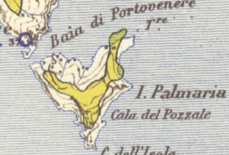
F. Ferretti, C. Sboarina, C. Tattoni, A. Vitti, P. Zatelli, F. Geri, E. Pompei, M. Ciolli
                                     The 1936 Italian Kingdom Forest Map reviewed: a dataset for landscape and ecological research

dello Stato in the frame of this work. The dimensions                                  example, the distribution of the main species and
of each image was approximately 112 Mb, 6’650 *                                        the general boundaries of the forests.
5’900 pixels, with a resolution of 400 ppi (pixel per                                      The forest cover at national level is divided
inch), RGB bands, projected in the Italian national                                    into 3 macrocategories (conifers, broadleaves and
Rome40 datum, Gauss-Boaga projection, east or                                          “degraded forests”) and 8 different categories,
west zone, depending on the location of the map                                        with some sub-categories related to forest system
sheet. The division into two different zones was                                       features for broadleaves (Fig. 2 translated in Tab.
maintained during the entire digitalization process,                                   1). The conifers sub-categories were classified de-
creating two different GRASS GIS Locations, Fuso                                       pending on the main species that can be found in
Est (East Zone) and Fuso Ovest (West Zone).                                            each polygon.
    Approximately 63’000 areas detected in the ras-
ter format were transformed into vector polygon
format.

The IKFM forest classification system
    The three levels system used in 1936 for the
classification of the forest in the IKFM was based
on species composition and silvicultural system,
highly related to a definite distinction between
wood for construction or furniture versus firewood
(Marchetti et al. 2009). The 1st World War had ended
a couple of decades before, and forests were an ir-
replaceable source of goods providing income and
satisfying many of the primary needs of the Italian
population (like firewood, bushmeat, mushrooms,
herbs used for food and medicines), not much dif-
ferent from what is happening now in some devel-
oping countries, in which the growing population                                       Figure 2 - IKFM original legend showing the different levels of the
                                                                                                  forest classification system represented with differ-
is increasingly impacting on forests and natural re-                                              ent colours, symbols and hatchings in 1936. The main
sources (Martin et al. 2012). The forest classification                                           categories are Resinose (Conifers), Faggio (Beech),
system chosen in the map description reflects the                                                 Rovere e Farnia (Sessile oak and English oak), Cerro
                                                                                                  (Turkey oak), Sughera (Cork oak), Castagno (Chestnut),
practical approach of the period but also contains                                                Altre specie o misti (other species or mixed wood), and
a large amount of ecological information, like, as an                                             Boschi degradati (Degraded forest). Detailed English
                                                                                                  translations of the names can be found in Tab S1.

Table 1 - Original label translated from italian (in brackets the original italian terms)

Macrocategory                     Category                                                                          Subcategory

Conifer (RESINOSE) Conifer (RESINOSE)                                                                               Norway spruce (ABETE ROSSO)
		                                                                                                                  Silver fir (ABETE BIANCO)
		                                                                                                                  Larch (LARICE)
		                                                                                                                  Stone pine (PINO DOMESTICO)
		                                                                                                                  other pines (PINI)

Broadleaves (LATIFOGLIE) Beech (FAGGIO)                                                                             high forest (alto fusto)
		                                                                                                                  coppice with standard (ceduo composto)
		                                                                                                                  coppice (ceduo)
                         Sessile oak and English oak
                         (ROVERE E FARNIA)                                                                          high forest
		                                                                                                                  coppice with standard
		                                                                                                                  coppice

  Turkey oak (CERRO)                                                                                                high forest
		                                                                                                                  coppice with standard
		                                                                                                                  coppice

  Cork oak (SUGHERA)                                                                                                high forest
		                                                                                                                  coppice with standard
		                                                                                                                  coppice

                    Chestnut (CASTAGNO)                                                                             high forest
		                                                                                                                  coppice with standard
		                                                                                                                  coppice
                    Other species or mixed wood
                    (ALTRE SPECIE O MISTI)                                                                          high forest
		                                                                                                                  coppice with standard
		                                                                                                                  coppice
Degraded forest
(BOSCHI DEGRADATI)

                                              Annals of Silvicultural Research - 42 (1), 2018: 3 - 19
                                                                                  5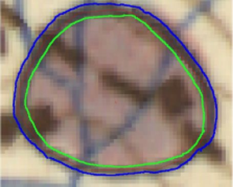
F. Ferretti, C. Sboarina, C. Tattoni, A. Vitti, P. Zatelli, F. Geri, E. Pompei, M. Ciolli
                           The 1936 Italian Kingdom Forest Map reviewed: a dataset for landscape and ecological research

Map digitalisation                                                                   and in this case we inserted the value 0 in
    The digitization work was carried out using the                                  the field VALUE; the second possibility for
open source software GRASS 6.4.3 (Neteler et al.                                     purple (conifer) areas was that one or more
2012, Preatoni et al. 2012, Zambelli et al. 2013) and                                forest subcategories symbols, each indicat-
QGIS Quantum GIS version 1.4.0-Enceladus.                                            ing the presence of a conifer species, were
    Because the amount of cartographic material                                      represented. In this second case, we inserted
was huge, an approach to limit the use of manual                                     the value 0 in the field VALUE, but we also
digitalization has been tested, with the use of the                                  counted the number of symbols of different
supervised image classification procedure available                                  subcategories and inserted it into the field
in GRASS to extract the forest data. To facilitate                                   RESINOSE (conifers) according to the fol-
automatic detection, various pre-processing tech-                                    lowing codification:
niques were applied, combining colour separation                                 AR = abete rosso (Picea abies Karst, European
with filtering and map algebra.                                                      Spruce)
    This approach did not give good results, with                                AB = abete bianco (Abies Alba Mill., European
many problems due to the original data quality and                                   silver fir)
many ambiguous situations in which the interven-                                 L = larice (Larix decidua Mill., European Larch)
tion of the operator is fundamental. Some map                                    P = pini (Pinus sp. Pines)
sheets presented defects due to scanning problems,                               PD = pino domestico (Pinus pinea L., Stone
and some imperfections regarding colour represen-                                    Pine).
tation were due to the original print process.                                   Because the only information available about
    The use of the automatic extraction technique                            the abundance of the conifer species is the number
has been applied to different sample map sheets, and                         of species symbols reported in each conifer area
the time necessary to complete the semi-automatic                            of the map, we decided to preserve the historical
procedure, consisting of the automatic extraction                            information by decoding it into a text label to facili-
and successive manual correction, has been com-                              tate data extraction via Structured Query Language
pared to the time necessary to accomplish the same                           (SQL). For example, an area in which we can count
task using a completely manual procedure, and the                            symbols for 10 spruces, 4 firs, 3 larches and 1 pine
latter has been shown to take up to 50% less time.                           will contain in the RESINOSE (conifer) field the
    The semi-automatic procedure was slower be-                              label 10AR4AB3L1P.
cause the time needed to correct errors due to the                               Apart from digitalisation errors, the size of the
misinterpretation of colours, bad signs on the map                           smallest polygon is about 0.14 hectares. Areas of this
or incorrect hatching was much higher than the time                          size are clearly visible in the original map and are
the operator needs to make a decision on what to do                          compatible with similar maps generated at the same
during the manual digitalization process.                                    scale in the same period in Europe (Kaim et al 2014).
    The following rules were observed during the                                 The Italian boundary was derived from the map
digitization:                                                                (shape file, Gauss-Boaga/Rome40) available on the
    a) always assign to each area the corresponding                          Italian National Institute of Statistics (ISTAT) web-
        subcategory according to original legend (Fig.                       site (http://www.istat.it/en).
        2, Tab S1);
    b) always digitize the black borders and not                             Projection and reference system transformation
        the coloured area extent, unless the black                           errors
        external border is absent. In this case, the                             The overall geometric uncertainties for the co-
        coloured area extent is digitized;                                   ordinates in the final vector map can be assessed as
    c) always follow the black border, even if part                          the sum of three terms: the geometric uncertainties
        of the border covers a lake or the sea surface;                      of the original map, errors introduced by the datum
    d) in the case of an area without well-defined                           transformation and inaccuracy during the vectori-
        hatching, common sense has been used;                                alization. The first term is easily estimated from the
    e) in the case of an area without colour, because                        scale of the original map: a scale of 1:100’000 cor-
        it was not possible to assign the area to a                          responds to an expected accuracy of 20 m.
        specific subcategory, the value 25 in the field                          Datum transformation errors are not available
        VALUE has been inserted, corresponding to                            for the transformation used in this application, but
        the label NON CLASSIFICABILE (not clas-                              their magnitude for the transformation between
        sifiable);                                                           these two datums can be reliably assumed to be of
    f) regarding the representation of purple (coni-                         the order of 10-20 cm (Radicioni & Stoppini 2009).
        fers), two cases were possible: the first was                            Finally, the digitalization error, excluding gross
        that the area was without any species symbol,                        errors in the choice of the correct feature, is less

                                    Annals of Silvicultural Research - 42 (1), 2018: 3 - 19
                                                                        6
F. Ferretti, C. Sboarina, C. Tattoni, A. Vitti, P. Zatelli, F. Geri, E. Pompei, M. Ciolli
The 1936 Italian Kingdom Forest Map reviewed: a dataset for landscape and ecological research
than half the size of a pixel. The pixel sizes vary
slightly approximately 6.5 m between raster sheets,
so this error can be estimated to be less than 3.5 m.
Consequently, the total error on the coordinates is
less than 30 m, with the original map accuracy being
the main factor.
The transformation from the original datum,
using a Bessel ellipsoid oriented around Genoa
and the Sanson-Flamsteed equal-area map projec-
tion, to the national one, using the Rome40 datum
with the Gauss-Boaga conformal projection, has
been carried out with a two-step procedure by the
former Corpo Forestale dello Stato. This procedure
involves the interpolation of the transformation pa- Figure 3 - Example of an area without colour filling (near the pink
rameters evaluated for the corners of each original area) and example of an area without a black border (the
map sheet. This transformation inevitably leads to yellow area at the bottom of the figure) in IKFM original
material.
a variation of the surfaces of the areas on the maps:
a complete analysis of this issue is under way, but
a first assessment has already been carried out. A
set of 46 map sheets, selected partly at random and
partly by choosing those sheets where the surface
variation is expected to be more relevant (i.e., the
sheets farthest from the central meridian and on the
north and south extremities of the region covered by
the map), has been tested by comparing the surface
of the original sheets to the reprojected ones.
According to this test, the variation of the surface
due to the reprojection procedure has a mean value
of 0.2%, with a maximum of 0.6% (std dev 0.2), and
it can be considered negligible with respect to the
other uncertainties involved. Figure 4 - An example of an area with the black border but without
colour filling is visible on the right side of the figure: the
Errors in the original map forest in this area is not classifiable.
The original map contained some recurring er-
rors, which are unavoidably also present in the ras-
ter format and thereby in the vector transformation.
The most frequent errors consist of the area
colour filling expanding beyond the black border of
the areas, the total or partial absence of the black
border with the presence of the colour filling (fig.
3 and fig. 4), the presence of the black border with
the total or partial absence of the colour filling and
the spreading of the black borders beyond terrain
limits into water bodies (fig. 5). Where possible,
the black borders have been used to define areas to
introduce the minimum modifications to the original
Figure 5 - Example of a forested area that partially overlapping the
paper map. sea in IKFM original material.
Another repeated error was the presence of
incongruous hatchings that began horizontally trying to respect the content of the original map as
and then became vertical or slanting or abruptly much as possible, but in some cases, the choice of
disappeared. Some of these errors are probably the forest subcategories involves a certain degree
due to inattention, and they were not corrected on of subjectivity.
the original map in 1936 because once the drawing
of the hatching was begun, it was not possible to Errors during digitalization
erase it and change it without redoing the whole During the digitalization process, there is the
sheet. The classification of these areas was done possibility that some polygons may be assigned by
Annals of Silvicultural Research - 42 (1), 2018: 3 - 19
7F. Ferretti, C. Sboarina, C. Tattoni, A. Vitti, P. Zatelli, F. Geri, E. Pompei, M. Ciolli
The 1936 Italian Kingdom Forest Map reviewed: a dataset for landscape and ecological research
the operator to the wrong category. A sample of one rors using the topology checker tools available in
hundred areas, chosen randomly, has been checked QGIS.
for misclassification and no errors were found, but
it is impossible to guarantee that all 63’000 forested Map availability
polygons have been correctly classified. IKFM has been made available, in both raster
An error that must be taken into account is the and vector format, in a WebGIS, as this type of tool
error due to the thickness of the lines. This error is allows the efficient distribution of geographic data
present in all paper maps and is due to the width and even data processing (Federici et al. 2013).
of the lines representing the graphical entities. The The map is available through the site carta1936.
smaller the scale, the larger this thickness error dicam.unitn.it. The data have been released in the
is. A one millimetre wide line, if represented in a Creative Commons licence and will be free to be
1:10’000 map, corresponds to a 10 m thick line on downloaded and used in the frame of European
the ground, and it corresponds to a 100 m thick line communication on open data (http://ec.europa.eu/
on the ground if represented in a 1:100’000 map. digital-agenda/en/open-data-0), with the obligation
To determine how this error can affect the final of citing the present paper as a reference.
results, some sampling has been carried out to meas- The system was made available on a virtual ma-
ure the widths of the boundaries of different areas chine containing both software and data.
in the original raster format. Most of the lines are 3 The virtual machine was built using VMware as
or 4 pixels wide, that is, 20-25 metres on the ground, virtualization software and Xubuntu 15.10 64 bit
but some of them are wider, up to approximately 50 as a guest OS. The WebGIS is based on Geoserver,
metres on the ground. Tomcat, PHP, OpenLayers, Ext.js, PostgreSQL,
To minimize this source of error, the lines have PostGIS and GRASS.
been digitized as close as possible to the centre of The WebGIS shows the IKFM in vector format,
their section. The effect of choosing the centre rath- using additional maps for the background to help
er than the inner or outer border of a boundary line the user identify the current location. The IKFM can
is shown in fig. 6, where the influence of this choice be downloaded in the shape file format.
on the resulting area can be easily appreciated. The digital map data set is based on the 276 maps
of Carta Forestale del 1936, and additional maps
were downloaded from official or free databases
that can be found on the web. The Italian state,
region and province boundaries were downloaded
from the ISTAT site, and maps with the Slovenian
and Croatian borders were downloaded from the
GADM database of Global Administrative Areas
(http://www.gadm.org/). Maps with the main roads,
rivers and railways were taken from the www.Open-
StreetMap.org site and were processed to reduce
the number of geographical entities. Maps with the
lakes (category 5.1.2 Inland waters, Water bodies)
were derived from Corine Land Cover version 13
(02/2010) using the Italian boundaries.
Figure 6 - Variation of an area depending on the location of the The data are displayed using the spherical pro-
digitized boundary with respect to the original line jection EPSG:3857.
drawing in IKFM, external (blue), intermediate (red) and The vector IKFM forest data are represented us-
internal (green) margins of the border are indicated.
ing different colours for each of the 25 subcategories
The red line (intermediate part of the border) in the map, trying to be coherent with the original
corresponds to an area of 7.13 hectares (assumed category colours (Tab S1).
as 100%), while the green line (internal margin of In the download section of the WebGIS, it is pos-
the border) corresponds to an area of 6.43 hec- sible to select the maps to download. The system
tares (90.2% of the intermediate) and the blue line automatically selects the raster maps covering the
(external margin of the border) corresponds to an area in the current visualization window and clips
area of 8.08 hectares (113.3% of the intermediate). the vector map to the same window.
It is evident how different the extent of a polygon It is possible to download the whole vector map
can be when digitized on the internal or external in a single file for Fuso Ovest (west zone EPSG:3003)
margin of the border. and a single file for Fuso Est (east zone EPSG:3004),
The final data were checked for topological er- including Istria.
Annals of Silvicultural Research - 42 (1), 2018: 3 - 19
8F. Ferretti, C. Sboarina, C. Tattoni, A. Vitti, P. Zatelli, F. Geri, E. Pompei, M. Ciolli
The 1936 Italian Kingdom Forest Map reviewed: a dataset for landscape and ecological research
Tests on the data set spatial pattern of the existing forest in 1936, they
We carried out some basic analysis to verify the were also compared to photographic documentation
data reliability, to check some information about available in touristic images or postcards from the
the forest subcategories and to test the possibility same period (Tattoni et al. 2010).
of using vector IKFM data.
To emphasize the contribution that this map can Forest and land surface
offer to ecological studies, it has been used in a study A first apparently obvious use of IKFM data is to
on ecosystems and forest coverage. Therefore we collect simple statistics regarding the forest cover
selected a case study in which the modifications to total area and macrocategory distribution. The total
vegetation in the Trentino region, in the North-East forest area in the map is approximately 6’000,’000
of Italy, have been investigated over a period of time ha (Tab S2), with 76% broadleaves, 18.4% conifers
spanning almost two centuries (Tattoni et al. 2010, and 5.6% degraded forest. Overall, mixed forest
Ciolli et al. 2012). The digital IKFM map was com- (broadleaves or conifers) represents 42% of the
pared to historical cartography, aerial photographs total forest area. Nevertheless, a comparison of the
and Natura2000 ecosystem mapping. total values calculated using the IKFM digital data
Then, area values extracted from the IKFM digi- and the summary paper tables that were originally
tal version were compared to original IKFM tables provided by IKFM in 1936, containing the areas of
created by hand by Milizia Forestale personnel in the forest calculated for each administrative region
1936, and the results are presented. The IKFM forest (Province) and the macro regions or zones (north,
cover surfaces were compared to those of IFNI 1985 centre, south and islands), reserves some surprises.
and INFC 2005 to evaluate whether the results are in The area values in these tables are not coherent,
line with what is expected and to highlight possible as the same totals evaluated from different partial
problems and issues. subtotals are different, and nor do they agree with
Finally, some considerations of the forest cat- the areas computed from the digital map (Tab. 2).
egories and subcategories are presented, and some Table 2 - Comparison between areas from IKFM tables measured
IKFM landscape pattern metrics were compared and calculated by hand in 1936 and areas calculated
with GIS from the digital map (Italian boundaries at
(using Patch Analyst 3.1) among Italian regions in 1936). The four values should ideally coincide and
1936 to evaluate whether the results are reasonable should be similar to the digitized IKFM, but the sum
in terms of subcategories quality, quantity and dis- of the forest calculated for each administrative region
(province) and subtotals for macro regions (zones)
tribution. In our case (vector theme), edge calcula- are not coherent, probably due to the use of manual
tions include all the edge on the landscape including calculations in 1936. These tables were officially used
boundary edge. In order to set the parameters of the to produce statistics in the past, and this highlights the
importance of the digital version of this document.
Patch Analyst 3.1 procedure we considered ecologi-
Source Type of sum Surface ha difference %
cally relevant the differences between different for- compared
est subcategories and also relevant the differences to shp
between forest/no forest. IKFM report tables of the 5'519’900 14.0
paper provinces
IKFM report Summary of 6'047’460 5.7
Results paper forest-zones
IKFM report Summary of 6'057’462 5.6
The case study we selected (Tattoni et al. 2010, paper forest-province
Tattoni et al. 2011, Ciolli et al. 2012) is particularly Digitized IKFM fuso est with istria 6'415’473 -
shp + fuso ovest
interesting because reliable historical maps describ-
ing the land use in 1800 are available for Trentino The comparison (Tab S3) of the IKFM - that
(Buffoni et al. 2003). Other maps are available represents a picture of the Italian forest distribu-
from forest management plans from the 1950s or tion, cover and surface (Marchetti et al. 2009) in
by photo-interpretation of different series of aerial 1936 - with successive situations in 1985 (IFNI 1985)
photographs starting from 1954 and taken in 1973, and 2005 (IFNC 2005) shows different situations
1985, 1994, 2000 and 2006. and trends.
The information on the total forest cover from The same regions (Liguria and Trentino-Alto
the digital IKFM has been successfully compared Adige), have the highest values of forest cover per-
to the forest situation in 1859 and in 1954, and the centage in all three surveys. Conversely, the forest
results were used to draw conclusions about eco- cover percentage for Sardinia increases consider-
system fragmentation, forest expansion and future ably, exceeding the value for Tuscany in the 2005
scenarios (Tattoni et al. 2010, Tattoni et al. 2011, survey.
Ciolli et al. 2012, Tattoni et al 2017). To further test Overall, the forest cover increased by 43.9% in
whether the IKFM data correctly represent the 1985 and by 73.6% in 2005 with respect to 1936. The
Annals of Silvicultural Research - 42 (1), 2018: 3 - 19
9F. Ferretti, C. Sboarina, C. Tattoni, A. Vitti, P. Zatelli, F. Geri, E. Pompei, M. Ciolli
The 1936 Italian Kingdom Forest Map reviewed: a dataset for landscape and ecological research
1,400
1,200
IKFM total forest area (ha)
1,000 IFNI 1985 total forest area (ha)
INFC 2005 total forest area (ha)
Thousands of ha
800
600
400
200
0
Figure 7 - Forest coverage (hectares) in Italian regions as originally recorded from the analogue IKFM 1936 and two later forest inventories,
the IFNI 1985 Inventario Forestale Nazionale [Forest National Inventory] and the INFC 2005 Inventario Nazionale delle Foreste
[National Inventory of Forests]. An increasing trend can be observed across regions.
forest cover percentage grew from 20% to 28.8% to A very evident finding is that stone pine forests
34.7% over the same time span. feature a high mean shape index.
While the forest cover increased in every region,
the increment ranges from only 22.9% in Liguria to Discussion
more than 300% in Sardinia (Fig. 7) .
In IKFM, the most common forest species (fig. Forest and land surface
8) are 5: Broadleaves: other species or mixed wood, As reported before, the area values in Tab. 2 are
Quercus robur/Quercus petrea, Castanea sativa, not coherent.
Fagus sylvatica, and Mixed conifers (Abies alba, These differences are possibly due to a series
Picea abies, Larix decidua). of factors:
Landscape pattern metrics in 1936 a) approximation errors;
The application of some landscape pattern met- b) errors in the evaluation of the surfaces in 1936
rics allows for a comparison of each forest subcat- (the way they were computed is unknown,
egories in 1936 (Tab S4) and the total forest cover but the staff definitely measured the polygons
in the different regions of Italy in 1936 (Tab S5). For and performed the sum of all the areas by
exemplifying, we can consider a landscape analysis hand);
of the IKFM by region highlights the results of the c) involuntary omissions of some of the poly-
forest patch mean size, median size and total number gons;
for the Emilia-Romagna and Marche regions. Those d) transcription errors on the final document.
two regions showed low values of the forest mean It appears that the sum carried out in 1936 meas-
patch size and high total patch numbers; on the uring by hand the individual polygons and summing
opposite the patches in Trentino-Alto Adige were them up was not reliable. The different sums (Prov-
larger and significantly less numerous. ince, Summary of forests-zones and Summary of
Regarding the patterns of the different forest forests-province) should reach the same measures
species, Turkey oak woods usually features large of the total surface area, therefore some errors are
patches with mean patch sizes larger than those of present in the original paper documents (not in the
patches of beech forest. paper map). It is clear that summing up more than
Large patches are also common for Cork oak, 63’000 polygons by hand could introduce calculation
chestnut and mixed conifers. Mixed conifers ac- errors. It is therefore highly probable that if some of
count for a huge surface.
Annals of Silvicultural Research - 42 (1), 2018: 3 - 19
10F. Ferretti, C. Sboarina, C. Tattoni, A. Vitti, P. Zatelli, F. Geri, E. Pompei, M. Ciolli
The 1936 Italian Kingdom Forest Map reviewed: a dataset for landscape and ecological research
the forest statistics at the national level calculated Quercus suber
(coppices with standards)
in the 1930s and later periods relied on these paper
Quercus robur/petraea
data, these statistics obtained imprecise results.
The transformation of the IKFM into vector format Quercus cerris
makes available a more robust and consistent geo-
Castanea sativa
referenced database that can be analysed using GIS.
The comparison (Tab S3) of the IKFM with Fagus sylvatica
successive situations in 1985 (IFNI 1985) and 2005 Broadleaves: other species
or mixed wood
(IFNC 2005) is obviously affected by approximations
Pinus pinea
and errors, which can be described but not evalu-
ated; the main problems are due to the facts that Pinus
Pi spp
a) data have been collected using completely Abies alba
different instruments;
Picea abies
b) instructions given in 1936 to personnel for
the survey are unknown; Larix decidua
c) although minimal, transformations from Mixed conifers
(Abies , Picea, Larix)
analogue (paper) to digital maps inevitably
Degraded forest
introduce approximations.
Even with the considerations above, common to
other studies that deal with historical forest maps
Thousands of ha
(Kaim et al. 2014), a comparison (Vizzarri et al. 2015)
can lead to interesting considerations.
The comparison results (Tab S3) are compatible Figure 8 - Forest coverage in hectares according to the original
1936 categories of IKFM.
to the landscape dynamics described in the areas
(Falcucci et al. 2006), the general forest cover trend stand whether the forest landscape described by the
is confirmed in every region (Fig. 7) and the results categories and subcategories is plausible based on
are in line with what is expected and described and the peculiarities of the different regions and to de-
basically confirm the general validity of the IKFM termine whether the forest subcategories indicated
data. in the legend can be trusted. In Emilia-Romagna and
Regarding the reliability of the IKFM forest Marche regions the low values of the forest mean
classification system, some interesting considera- patch size and high total patch numbers can be
tions about the forest species (mixing categories explained by the fact that these regions are mostly
and subcategories) in IKFM arise from a simple covered by plains and low hills, with widespread
observation of the distribution of the different forest agricultural activity and a more fragmented forest
species (Fig. 8). environment. In mountainous areas with low popu-
The “Broadleaves, other species and mixed lation density and agricultural activity, the patches
wood” category is the most common, but it seems in 1936 were larger and significantly less numerous,
reasonable to suppose that this class includes every describing a forest management approach with large
forest that the surveyors were not able to classify, areas (Trentino-Alto Adige).
so it must be treated with caution. The Quercus Regarding the patterns of the different forest
robur/petraea is also very common but, according species, Turkey oak woods usually features large
to the knowledge of the 1936 forest species distri- patches, typical of diffuse forests cultivated wher-
bution, the suspicion is raised that mistakes in the ever possible, with mean patch sizes larger than
attribution of patches to Quercus cerris, Quercus those of patches of beech forest.
pubescens and Quercus robur/petrea have occurred. It is hard to tell how much the large surface of
This fact must be taken into account if data are used Mixed conifers is affected by the very general clas-
to compare the present situation, and the different sification.
IKFM Quercus species should be grouped into a The high mean shape index for stone pine forests
single one. is mostly due to the fact that their patches have
stretched shapes along the coasts.
Landscape pattern metrics in 1936
Considering the above examples, we can say
The application of some landscape pattern that despite the 1:100’000 scale of the IKFM, the
metrics allows for a comparison of each forest landscape patterns are compatible with the situa-
subcategories in 1936 (Tab S4) and the total forest tion in 1936 and contain very descriptive informa-
cover in the different regions of Italy in 1936 (Tab tion, at least for some classes, although the generic
S5). This comparison may be useful both to under- classification system suggests the need for caution
Annals of Silvicultural Research - 42 (1), 2018: 3 - 19
11F. Ferretti, C. Sboarina, C. Tattoni, A. Vitti, P. Zatelli, F. Geri, E. Pompei, M. Ciolli
The 1936 Italian Kingdom Forest Map reviewed: a dataset for landscape and ecological research
if researchers want to compare these classification the original forest classification and thereby of the
system across different periods. digitized data must be taken into account by users.
The considered case study clearly demonstrate We encourage the research community to per-
that with the digital format it is possible to create form further studies and comparisons using 1930s
maps for each forest subcategories that are useful, historical material at the national but also at the re-
in assessing forest subcategories distributions or gional and local levels that will help further elucidate
to build custom maps describing the status in 1936 the significance of the single forest subcategories
that can be checked against the current situation or adopted for the classification in IKFM.
historical data. Finally, the use of the digital IKFM in
determining the total forest cover is reliable. Acknowledgements
Conclusions The authors want to thank Michele Bortolotti
and the Direzione Sistemi Informativi, Servizi e
The availability of the IKFM makes it possible Tecnologie Informatiche, Università degli studi
to fill a gap in the Italian forest mapping timeline, di Trento for guesting the virtual machine of the
providing accurate, complete and interesting infor- WebGIS, Davide Giacomelli, Mario Sulli and Mas-
mation for researchers who are interested in the simo Bianchi for their support. The authors want to
study of landscape and ecological changes. thank the Accademia Italiana di Scienze Forestali
The transformation into vector polygons allows that guested the Workshop: “La Carta Forestale del
the manipulation of data through the connected Regno d’Italia: 80 anni di evoluzione delle foreste
database, exploiting its efficiency and flexibility in italiane” in Firenze February the 4th 2016 to present
data querying and processing. the WebGIS see the site: sisef.org/2016/01/18/work-
SQL allows a profitable storage of otherwise shop-la-carta-forestale-del-regno-ditalia-80-anni-di-
unavailable information, like the numbers of conifer evoluzione-delle-foreste-italiane-firenze-04022016/
symbols, although the reliability of these data must and the SISEF Working Group Gestione Forestale.
be carefully investigated.
The information in the IKFM map has already References
proven to be useful in reconstructing the total for-
est cover in past situations at local scale (Geri et al. Aggemyr E., Cousins S.A.O. 2012 - Landscape structure and
2010, Tattoni et al. 2010, Tattoni et al. 2011, Ciolli et land use history influence changes in island plant com-
al. 2012, Amici et al. 2013, Biasi et al. 2015, Salvati position after 100years. Journal of Biogeography 39 (9):
et al. 2015, Tattoni et al 2017) and at country scale 1645-1656.
(Cammaretta et al. 2017, in the press). Amici V., Rocchini D., Geri F., Bacaro G., Marcantonio M.,
Because the Italian border changed before and Chiarucci A. 2012 - Effects of an afforestation process on
plant species richness: A retrogressive analysis. Ecological
after 1936, the data in this map have a super-national
Complexity 9: 55-62.
value. Some forest areas mapped in the IKFM are
Amici V., Santi E., Filibeck G., Diekmann M., Geri F., Landi S.,
presently part of Slovenia, Croatia or France and Scoppola A., Chiarucci A. 2013 - Influence of secondary
can now be used to study forest changes in those forest succession on plant diversity patterns in a Mediter-
countries. Moreover, the borders of Italy touch ranean landscape, Journal of Biogeography 40, 2335–2347.
France, Switzerland, Austria, Slovenia and Croatia, Biasi R., Colantoni A., Ferrara C., Ranalli F., Salvati L. 2015 - In-
and researchers in all these countries may be in- between Sprawl and Fires: long-term Forest Expansion
terested in the historical ecological features on the and Settlement Dynamics at the Wildland-Urban Interface
in Rome, Italy. International Journal of Sustainable Devel-
boundaries, as the borders can have a significant
opment and World Ecology 22(6): 467-475.
effect on their neighbourhood.
Bieling C., Plieninger T., Schaich H. 2013 - Patterns and causes
Given the currently available GIS tools and the of land change: Empirical results and conceptual consid-
features of the original material, the manual inter- erations derived from a case study in the Swabian Alb,
pretation and digitization was more productive than Germany. Land Use Policy 35: 192-203.
a mixed approach based on automatic recognition Bracchetti L., Carotenuto L., Catorci A. 2012 - Land-cover
and a posteriori manual correction. The descrip- changes in a remote area of central Apennines (Italy) and
tion of how we dealt with the many technical and management directions. Landscape and Urban Planning
104 (2): 157-170.
practical problems encountered in the creation of
this map can be useful for the digitization of similar Brengola A. 1939 - La carta Forestale d’Italia. [The Italian
Forest Map] Rivista Forestale Italiana. Milizia Nazionale
historical maps in other contexts. Forestale. Comando Centrale, Roma, 1-10. ISSN: 1594-686X
The studies in the historical archive and the tests
Buffoni D., Leoni D., Bortolamedi R. 2003 - L'eredità carto-
we carried out highlight validity of the IKFM for GIS grafica catastale degli Asburgo in forma digitale. [The
processing, although the limits and uncertainties of Habsburgic cadastre cartographic heredity in digital
Annals of Silvicultural Research - 42 (1), 2018: 3 - 19
12F. Ferretti, C. Sboarina, C. Tattoni, A. Vitti, P. Zatelli, F. Geri, E. Pompei, M. Ciolli
The 1936 Italian Kingdom Forest Map reviewed: a dataset for landscape and ecological research
format] in Atti della 6a Conferenza Nazionale ASITA. Geo- Serbatoi Forestali di Carbonio. MiPAF - Corpo Forestale
matica per l'Ambiente, il Territorio e il Patrimonio Culturale, dello Stato - Ispettorato Generale, CRA - ISAFA, Trento. [on
Perugia, 5-8 November 2002 Vol 1 pp 559-564. line] Available: http://www.infc.it. Accessed May 2017 09
Camarretta N., Chiavetta U., Puletti N., Corona P. 2017 - Quan- Kaim D., Kozak J., Ostafin K., Dobosz M., Ostapowicz K., Kolecka
titative changes of forest landscapes over the last century N., Gimmi U. 2014 - Uncertainty in historical land-use
across Italy. Plant Biosystem (in the press) https://doi.org/ reconstructions with topographic maps. Quaestiones
10.1080/11263504.2017.1407374. Geographicae, 33(3): 55–63 - doi: 10.2478/quageo-2014-0029
Cimini D., Tomao A., Mattioli W., Barbati A., Corona P. 2013 Marchetti M., Chiavetta U., Santopuoli G. 2009 - La cartografia
- Assessing impact of forest cover change dynamics on forestale su base tipologica della Regione Abruzzo: dai
high nature value farmland in Mediterranean mountain “prodromi” alla carta forestale dell’Italia centrale. [The
landscape. Annals of silvicultural research 37(1):29-37. forest type cartography of Abruzzo region: from the prel-
Ciolli M., Tattoni C., Ferretti F. 2012 - Understanding forest ude to Central Italy forest map]. Available: http://www.
changes to support planning: A fine-scale Markov chain academia.edu/795865/La_cartografia_forestale_su_base_
approach. in F Jordán, Se Jørgensen (edited by), Models of tipologica_della_Regione_Abruzzo_dai_prodromi_alla_
the ecological hierarchy from molecules to the ecosphere, carta_forestale_dellItalia_centrale . Accessed May 2017 09
Great Britain: Elsevier, 2012:341-359. (Developments in Marignani M., Rocchini D., Torri D., Chiarucci A., Maccherini S.
Environmental Modelling; 25) 2008 - Planning restoration in a cultural landscape in Italy
Corona P., Chirici G., Marchetti M. 2002 - Forest ecosystem using an object-based approach and historical analysis.
inventory and monitoring as a framework for terrestrial Landscape and Urban Planning, 84 (1): 28-37.
natural renewable resource survey programmes. Plant Martin A., Caro T., Mulder M.B. 2012 - Bushmeat consumption
Biosystems 136: 69–82 in western Tanzania: A comparative analysis from the
Corona P., Marchetti M., Morgante L., Di Pietro R. 2001 - Car- same ecosystem. Tropical Conservation Science 5 (3):
tografia sperimentale e prodromi di una tipologia dei 352-364.
boschi dell’appennino abruzzese. [Experimental cartog- Merler S., Furlanello C., Jurman G. 2005 - Machine learning on
raphy and prelude to a forest type category of Abruzzo historical air photographs for mapping risk of unexploded
Apennine] Annali Accademia Italiana di Scienze Forestali bombs. 13th International Conference on Image Analysis
XLIX-L: 175–241 and Processing (ICIAP2005), Lecture Notes in Computer
Falcucci A., Maiorano L., Boitani L. 2006 - Changes in land- Science, Vol. 3617: 735-742.
use/land-cover patterns in Italy and their implications Meyer E. 2012 - Turismo e storia della produzione cartografica:
for biodiversity conservation. Landscape Ecology, 22(4): la carta d’Italia del Touring Club italiano al 250.000.
617–631. doi:10.1007/s10980-006-9056-4 [Tourism and history of cartography: the 1:250.000
Federici B., Giacomelli D., Sguerso D., Vitti A., Zatelli P. 2013 Italian map of Touring Club Italiano] Fondazione Luigi
- A web processing service for GNSS realistic planning. Micheletti Centro di ricerca sull'età contemporanea [on
Applied Geomatics 5 1: 45-57. line 4 February 2016]. Available: http://www.fondazi-
onemicheletti.eu/contents/documentazione/archivio/
Garbarino M., Lingua E., Weisberg P.J., Bottero A., Meloni F., Altronovecento/Arc.Altronovecento.06.04.pdf . Accessed
Motta R. 2013 - Land-use history and topographic gradi- May 2017 09
ents as driving factors of subalpine Larix decidua forests.
Landscape Ecology 28 (5): 805-817. Mikusinska A., Zawadzka B., Samojlik T., Jedrzejewska B.,
Mikusiński G. 2013 - Quantifying landscape change dur-
Geri F., Rocchini D., Chiarucci A. 2010 - Landscape metrics and ing the last two centuries in Bialowieża Primeval Forest.
topographical determinants of large-scale forest dynam- Applied Vegetation Science, 16 (2): 217-226.
ics in a Mediterranean landscape. Landscape and Urban
Planning 95 (1-2): 46-53. Neteler M., Bowman M.H., Landa M., Metz M. 2012 - GRASS
GIS: A multi-purpose open source GIS. Environmental
Geri F., La Porta N., Zottele F., Ciolli M. 2016 - Mapping histori- Modelling and Software 31: 124-130. doi: 10.1016/j.envs-
cal data: Recovering a forgotten floristic and vegetation oft.2011. 11.014
database for biodiversity monitoring ISPRS Interna-
tional Journal of Geo-Information, 5 (7) 100. doi: 10.3390/ Palombo C., Chirici G., Marchetti M., Tognetti R. 2013 - Is land
ijgi5070100 abandonment affecting forest dynamics at high elevation
in Mediterranean mountains more than climate change?
Glavan M., Pintar M., Volk M. 2013 - Land use change in a 200- Plant Biosystems, 147 (1): 1-11.
year period and its effect on blue and green water flow in
two slovenian mediterranean catchments-lessons for the Pezzi G., Maresi G., Conedera M., Ferrari C. 2011 - Woody
future. Hydrological Processes 27 (26): 3964-3980. species composition of chestnut stands in the Northern
Apennines: The result of 200 years of changes in land use.
Ianni E., Geneletti D., Ciolli M. 2015 - Revitalizing Traditional Landscape Ecology 26 (10): 1463-1476.
Ecological Knowledge: A Study in an Alpine Rural Com-
munity. Environmental Management, 56 (1): 144-156 Preatoni D.G., Tattoni C., Bisi F., Masseroni E., D'Acunto D., Lu-
nardi S., Grimod I., Martinoli A., Tosi G. 2012 - Open source
IFNI. 1985 - Inventario forestale nazionale-Sintesi metodo- evaluation of kilometric indices of abundance. Ecological
logica e risultati. [Forest National Inventory – Methods Informatics 7(1):35-40. doi: 10.1016/j.ecoinf.2011.07.002
and results] MAF – Direzione generale per l’economia
montana e per le foreste - Corpo Forestale dello Stato, Quantum GIS Development Team 2010, last visited 20/3/2014.
ISAFA, Trento. pp 462. Quantum GIS Geographic Information System. Available
at http://www. qgis.org
INFC. 2007 - Le stime di superficie 2005 – Prima parte. [For-
est cover estimate 2005] G. Tabacchi, F. De Natale, L. Di Radicioni F., Stoppini A. 2009 - Datum e coordinate nella ge-
Cosmo, A. Floris, C. Gagliano, P. Gasparini, L. Genchi, G. odesia. http://labtopo.ing.unipg.it/files_sito/aurelio/5%20
Scrinzi, V. Tosi. Inventario Nazionale delle Foreste e dei
Annals of Silvicultural Research - 42 (1), 2018: 3 - 19
13F. Ferretti, C. Sboarina, C. Tattoni, A. Vitti, P. Zatelli, F. Geri, E. Pompei, M. Ciolli
The 1936 Italian Kingdom Forest Map reviewed: a dataset for landscape and ecological research
-%20DATUM%20E%20COORDINATE.pdf, visited 23/10/2017 Tattoni C., Ciolli M., Ferretti F. 2011 - The fate of priority areas
Renó V.F., Novo E.M.L.M., Suemitsu C., Rennó C.D., Silva T.S.F. for conservation in protected areas: a fine-scale Markov
2011 - Assessment of deforestation in the Lower Amazon chain approach. Environmental Management 47(2): 263-
floodplain using historical Landsat MSS/TM imagery. 278. Springer Verlag. Available: http://www.springerlink.
Remote Sensing of Environment 115 (12): 3446-3456. com/content/k532520665515um2/ . Accessed May 2017 09
Sacchelli S., Zambelli P., Zatelli P., Ciolli M. 2013 - Biomasfor Tattoni C., Ciolli M., Ferretti F., Cantiani M.G. 2010 - Monitoring
An open source holistic model for the assessment of sus- spatial and temporal pattern of Paneveggio forest (north-
tainable forest bioenergy. iForest 6:285-293. doi: 10.3832/ ern Italy) from 1859 to 2006. iForest 3(2): 72-80. - - doi:
ifor0897-006. 10.3832/ifor0530-003
Salvati L., Biasi R., Carlucci M., Ferrara A. 2015 - Forest tran- Uuemaa E., Antrop M., Marja R., Roosaare J., Mander Ü. 2009
sition and urban growth: exploring latent dynamics - Landscape Metrics and Indices : An Overview of Their
(1936-2006) in Rome, Italy, using a geographically Use in Landscape. Living Reviews in Landscape Research,
weighted regression and implications for coastal forest 3, 1–28. - doi: 10.12942/lrlr-2009-1
conservation. Rendiconti Accademia Nazionale dei Lincei Vizzarri M., Chiavetta U., Chirici G., Garfì V., Bastrup- Birk A.,
26(3): 577-585. Marchetti M. 2015 - Comparing multisource harmonized
Schirpke U., Leitinger G., Tappeiner U., Tasser E. 2012 - SPA- forest types mapping: a case study from central Italy. iFor-
LUCC: Developing land-use/cover scenarios in mountain est – Biogeosciences and Forestry, 8(1), 59– 66. doi:10.3832/
landscapes. Ecological Informatics 12: 68-76. ifor1133-007
Sitzia T., Semenzato P., Trentanovi G. 2010 - Natural refor- Vota G. 1954 - I sessant’anni del Touring Club Italiano 1894-
estation is changing spatial patterns of rural mountain 1954. [Sixty years of Touring Club Italiano 1894-1954]
and hill landscapes: A global overview. Forest Ecol- Milano, Tci, 1954: 109-117.
ogy and Management, 259(8): 1354–1362. doi:10.1016/j. Zald H.S.J. 2008 - Extent and spatial patterns of grass bald
foreco.2010.01.048 land cover change (1948–2000), Oregon Coast Range,
Tang J., Bu K., Yang J., Zhang S., Chang L. 2012 - Multitemporal USA. Plant Ecology, 201(2): 517–529. - doi: 10.1007/s11258-
analysis of forest fragmentation in the upstream region 008-9511-1
of the Nenjiang River Basin, Northeast China. Ecological Zambelli P., Gebbert S., Ciolli M. 2013 - Pygrass: An Object
Indicators, 23: 597-607. Oriented Python Application Programming Interface
Tappeiner U., Tasser E., Leitinger G., Tappeiner G. 2007 - Land- (API) for Geographic Resources Analysis Support System
nutzung in den Alpen: historische Entwicklung und zu- (GRASS) Geographic Information System (GIS). ISPRS
kunftige Szenarien, vol 1. Alpine space man & environment: International Journal of Geo-Information, (2): 201-219. - doi:
Die Alpen im Jahr 2020. Innsbruck University Press: 23–39 10.3390/ijgi2010201
Tattoni C., Ianni E., Geneletti D., Zatelli P., Ciolli M. 2017 - Land- Zhou W., Huang G., Pickett S.T., Cadenasso M.L. 2011 - 90 Years
scape changes, traditional ecological knowledge and future of Forest Cover Change in an Urbanizing Watershed: Spa-
scenarios in the Alps: A holistic ecological approach. Sci- tial and Temporal Dynamics. Landscape Ecology 26(5):
ence of the Total Environment, 579:27-36. DOI: 10.1016/j. 645–659. - doi:10.1007/s10980-011-9589-z
scitotenv.2016.11.075 Zlinszky A., Timár G. 2013 - Historic maps as a data source for
socio-hydrology: A case study of the Lake Balaton wetland
system, Hungary. Hydrology and Earth System Sciences
17(11): 4589-4606
Annals of Silvicultural Research - 42 (1), 2018: 3 - 19
14F. Ferretti, C. Sboarina, C. Tattoni, A. Vitti, P. Zatelli, F. Geri, E. Pompei, M. Ciolli
The 1936 Italian Kingdom Forest Map reviewed: a dataset for landscape and ecological research
Tab S 1: VALUES is the ID number of the subcategory, COLOUR is the colour that represents the IKFM category, LABEL is the original IKFM
subcategories label, GRASSRGB is the RGB (Red, Green, Blue) value that encodes the colour in GRASS that matches the original
colour of the paper map.
VALUE COLOR LABEL GRASSRGB
0 purple – viola Conifer - RESINOSE 155:80:125
1 purple – viola Conifer Norway spruce - RESINOSE ABETE ROSSO 155:80:125
2 purple – viola Conifer Silver fir - RESINOSE ABETE BIANCO 155:80:125
3 purple – viola Conifer Larch - RESINOSE LARICE 155:80:125
4 purple - viola Conifer other pines - RESINOSE PINI 155:80:125
5 purple - viola Conifer Stone pine - RESINOSE PINO DOMESTICO 155:80:125
6 blue - azzurro Beech high forest - FAGGIO alto fusto 123:169:156
7 blue - azzurro Beech coppice with standard - FAGGIO ceduo composto 123:169:156
8 blue - azzurro Beech coppice - FAGGIO ceduo 123:169:156
9 brown - marrone Sessile oak and English oak high forest - ROVERE E FARNIA alto fusto 150:35:35
10 brown - marrone Sessile oak and English oak coppice with standard - ROVERE E FARNIA ceduo composto 150:35:35
11 brown - marrone Sessile oak and English oak coppice - ROVERE E FARNIA ceduo 150:35:35
12 brown - marrone Turkey oak high forest - CERRO alto fusto 150:35:35
13 brown - marrone Turkey oak coppice with standard - CERRO ceduo composto 150:35:35
14 brown - marrone Turkey oak coppice - CERRO ceduo 150:35:35
15 orange - arancione Cork oak high forest - SUGHERA alto fusto 255:120:15
16 orange - arancione Cork oak coppice with standard - SUGHERA ceduo composto 255:120:15
17 orange - arancione Cork oak coppice - SUGHERA ceduo 255:120:15
18 green - verde Chestnut high forest - CASTAGNO alto fusto 125:160:80
19 green - verde Chestnut coppice with standard - CASTAGNO ceduo composto 125:160:80
20 green - verde Chestnut coppice - CASTAGNO ceduo 125:160:80
21 yellow - giallo Broadleaves: other species or mixed wood high forest -
ALTRE SPECIE O MISTI alto fusto 255:190:65
22 yellow - giallo Broadleaves: other species or mixed wood coppice with standard -
ALTRE SPECIE O MISTI ceduo composto 255:190:65
23 yellow - giallo Broadleaves: other species or mixed wood coppice -
ALTRE SPECIE O MISTI ceduo 255:190:65
24 pink - rosa Degraded forest - BOSCHI DEGRADATI 243:87:125
25 none - nessuno Not classifiable - NON CLASSIFICABILE
99 none - nessuno Island - ISOLA
Annals of Silvicultural Research - 42 (1), 2018: 3 - 19
15You can also read