THE LARES LIMESTONE AND MONTEBELLO MEMBER OF THE CIBAO FORMATION ALONG HIGHWAY PR10 - FIELD TRIP GUIDE BY WILSON R. RAMÍREZ-MARTÍNEZ, BS, MS, PHD ...
←
→
Page content transcription
If your browser does not render page correctly, please read the page content below
The Lares Limestone and Montebello Member
of the Cibao Formation along Highway PR10

                   Field Trip Guide

                          by
      Wilson R. Ramírez-Martínez, BS, MS, PhD, PG

          University of Puerto Rico, Mayagüez
                 Mayagüez, P.R. 00681
INTRODUCTION
Stratigraphic Nomenclature of Tertiary Rocks in Northern Puerto Rico
The Council of the New York Academy of Science sponsored the first
scientific survey of Puerto Rico (Berkey, 1915). The survey included
paleontology, botany, zoology, anthropology and geology. The principal
geologic features of Puerto Rico are described as an older series of late Mesozoic
rocks overlain by a younger series of Cenozoic rocks. The younger series was
divided into two formations: the San Juan Formation and the Arecibo Formation.
Later in 1919, Berkey suggested a division of the Arecibo Formation into a upper
limestone member, the Quebradillas, and a lower shale member, the San
Sebastián.
After Berkey’s (1915) preliminary study, the New York Academy of
Science divided the island into seven districts. These seven districts were
assigned to different geologists. The middle Tertiary rocks of northwestern
Puerto Rico were divided by Hubbard (1923) into (from oldest to youngest) the
San Sebastián Shale Formation, the Lares Limestone, the Cibao Formation, the
Los Puertos Formation and the Quebradillas Limestone Formation (Fig. 1). After
Hubbard (1923), Zapp et al. (1948) divided the rocks that were younger than the
Cibao Formation into the Aguada and Aymamón Limestone Formations (see Fig.
1).
In 1957, the U.S. Geological Survey and the PREDA (Department of
Industrial Research of the Puerto Rico Economic Development Administration)
2began detailed mapping of the middle and upper Tertiary rocks that was
completed in 1970. The Los Puertos Formation and Quebradillas Limestone
Formation of Hubbard (1923) were renamed the Aguada Limestone Formation,
Aymamón Limestone Formation and Camuy Formation (Zapp et al., 1948) in
Monroe's (1973) stratigraphic summary of the middle Tertiary rocks in Puerto
Rico. Disagreement still existed on this matter as we can see in Meyerhoff (1975),
where he used Hubbard's (1923) stratigraphic divisions (see Fig. 1).
The Aguada Limestone Formation type-section chosen by Zapp et al.
(1948) was discovered by Monroe (1968) to be actually in Hubbard's (1920) Cibao
Formation. Furthermore, Meyerhoff (1975) noted that the base of the Aguada
Limestone Formation and Los Puertos Formation was at the same stratigraphic
position. These two facts led to the conclusion that the Aguada Limestone
Formation and Los Puertos Formation represented the same units. Monroe
(1968) attempted to rectify the problem by defining a reference section for the
Aguada Limestone Formation. However, Seiglie and Moussa (1975) argued that
Hubbard's (1920) name had priority, first because the Aguada Limestone
Formation type section was improperly defined, and second, because the
essentially equivalent Los Puertos Formation was defined earlier.
An island-wide unconformity between Los Puertos Formation (Aguada
Limestone) and Aymamón Limestone was described by Seiglie and Moussa
(1984) and Meyerhoff et al., (1983). Meyerhoff et al., (1983) named the unit above
this unconformity the Moca Limestone Formation. This unit has not been
defined formally as a rock-stratigraphic unit, and the name Aymamón Limestone
is still used for the unit(s) between Los Puertos Formation (Aguada Limestone)
and the Quebradillas Limestone (see Fig. 1). The name Aymamón Limestone
3will probably be replaced if new type sections are designated. Seigle & Moussa
(1975) and Meyerhoff (1975) also argued that the Camuy Formation of Monroe
(1963a) is essentially similar to the Quebradillas Limestone of Hubbard (1923),
even though the Quebradillas Limestone Formation is thicker than the Camuy
Formation. Seigle and Moussa (1975) redefined the type section of the
Quebradillas Limestone, making it essentially equivalent to the Camuy
Formation. This invalidated the name "Camuy Formation " since the
Quebradillas Limestone name had priority (see Fig. 1).
The stratigraphic nomenclature used here for units of the middle and
upper Tertiary section will follow the nomenclature currently used by Ward et
al., in press (see Fig. 1), which follows for the most part the nomenclature used by
the U.S. Geological Survey. The major stratigraphic divisions are, in ascending
order: the San Sebastián Formation, the Lares Limestone, the Cibao Formation,
the Aguada (Los Puertos) Limestone Formation, the Aymamón (Moca)
Limestone, and the Quebradillas (Camuy) Limestone. On the eastern side of the
basin, the Lares Limestone and the Cibao Formation interfinger with the
Mucarabones Formation. In the west-central part of the basin, the Montebello
Member of the Cibao Formation lies between the Lares Limestone and the
undifferentiated Cibao Formation, but in the east-central basin, the mudstone
unit, the Río Indio, and the Quebrada Arenas Limestone Members of the Cibao
Formation occupy this stratigraphic position (see Fig. 1). These stratigraphic
units range in age from middle Oligocene to Pliocene.
The northern limit of the North Coast Basin reaches the Puerto Rican
Trench but the original southern limit of the basin is not known. The maximum
thickness recorded in a well was 1,684 m at the test well 4-CPR, drilled between
4Arecibo and Barceloneta (Briggs, 1961). Based on seismic data, the maximum
onshore sedimentary rocks thickness may be around 2,000 m and the maximum
offshore sedimentary rocks thickness may reach 2,500 m to 3,500 m (Meyerhoff et
al., 1983).
This field trip will be focused on the carbonate rocks of the Lares
Limestone and Montebello Member of the Cibao Formation.
The Lares Limestone and Montebello Member
of the Cibao Formation
The Lares Limestone
The upper Oligocene-lower Miocene Lares Limestone overlies the San
Sebastián Formation (Seiglie and Moussa, 1984). The unit is composed
predominantly of thickly bedded, fine-to medium-grained calcarenite, and in
most places, is found in gradational contact with the underlying San Sebastián
Formation (Hartley, 1989). Less commonly, especially over the larger structural
uplifts and in the areas where the San Sebastián Formation is missing, the
formation rests directly on the basement (Monroe, 1980a). This lower
diachronous boundary is interpreted as deposition during a marine
transgression (Briggs and Gordon, 1961; Meyerhoff et al., 1983).
The Lares Limestone crops out in a continuos belt of limestone in the
northern coast of the island (Fig. 2). The outcrop thickness ranges from 270 m
east of the Bayaney quadrangle where it has a fairly constant thickness, to a
maximum thickness of 301 m in the Bayaney quadrangle (Monroe 1980a). The
5formation pinches out in the western and eastern edges of the outcrop belt. In
the subsurface the Lares Limestone thickness ranges from 0 to 500 m (Heisel et
al., 1983; Hartley, 1989; Ward et al., in press).
The Lares Limestone was deposited on a broad 25-km-wide shelf rich in
marine organisms that were similar to those living in modern reef environments
(Frost et al., 1983). The main mass of limestone never formed a lens-like mass,
but was developed as tongues of limestone projecting laterally into clastic beds
(Frost et al., 1983). The western and eastern boundaries of the basin are
dominated by fluvial deposits (Monroe 1980a).
Frost et al. (1983) interpreted three cycles of reef growth from the Lares
exposed section on P.R. 129. First, a reef framework of massive corals was
truncated by subaerial exposure. A second cycle of fringing-reef growth also
was terminated by erosion. Finally, a third cycle of reef growth developed under
tectonically stable conditions and prograded seaward with backreef material and
skeletal-sand shoals capping the sequence.
In the subsurface the lower to middle Lares Limestone records a
continuation of a transgression that began with the upper San Sebastián
Formation (Hartley, 1989). The upper Lares Limestone represents a regressive
stage that lasted through deposition of the lower Montebello Member. These
transgressions and regressions were identified by Hartley (1989) by recognizing
differences in depositional environments between the lower, middle and upper
Lares Limestone. According to Hartley (1989), the lower Lares Limestone
indicates deposition in a low-energy, open-marine environment, the middle
Lares Limestone formed in a shallow-marine environment, and the upper Lares
Limestone lithologies represent near-shore environments.
6The Lares Limestone is overlain by the undifferentiated Cibao Formation
or by the different members of the Cibao Formation depending on the specific
location on the northern coast of the island (see Fig. 1). In the west-central part
of the Puerto Rico North Coast Basin, the Lares Limestone overlain by the
Montebello Member of the Cibao Formation. This contact is easily identified on
outcrop exposures by a bed of oyster shells that can range from 1 to 5 m thick
(Monroe, 1980a). Individual oysters in this bed can be as much as 12 cm in
diameter.
The Montebello Member of the Cibao Formation
In the west-central part of the island the boundary between the Lares
Limestone and the Montebello Member of the Cibao Formation is exposed
northeast of the town of Ciales and marks a change in lithologic character and
thickness of the limestone (Fig. 3). In this area the Montebello Member is
composed largely of foraminifers and fragments of molluskan shells and
includes beds of large oysters (Monroe, 1980a). The Montebello Member is the
most laterally and stratigraphically extensive member unit of the Cibao
Formation and it grades to the west and east into the undifferentiated Cibao
Formation marly limestones (Figs. 3 & 4). The type locality of the Montebello
Member is in the Florida quadrangle 1.2 km southeast of the town of Montebello.
In this area, the Montebello Member is composed of pure calcium carbonate
(Monroe, 1980a).
In the subsurface, the Montebello Member is composed of shoaling-
upward sequences with the basal units being dominantly shallow middle-to-
7inner shelf deposits and the uppermost sequences composed of rocks deposited
in high-energy near-shore environments (Hartley, 1989). Just above the Lares
Limestone-Montebello Member contact an oyster wackestone bed forms a
convenient marker between the two formations. This bed is generally from 0.9 to
4.6 m in thickness and is present over an extensive area along the Lares
Limestone-Montebello Member exposures. Although evident in outcrop, the
oyster layer has been difficult to locate in the subsurface suggesting that the
Montebello Member pinches out downdip.
The Lares Limestone and MontebelloMember
along Highway PR10
Description of the units
Sections of the Lares Limestone and Montebello Member of the Cibao
Formation were exposed during the construction of the new PR10 road from
Arecibo to Utuado. The new highway exposed the entire thickness of the
Montebello Member in the area, making possible the construction of a
continuous stratigraphic section of the unit. The first complete stratigraphic
section of the Montebello Member ever measured at the surface was presented
in Ramírez-Martínez, 2001 unpublished Ph.D. Thesis. Some of the results
obtained follow.
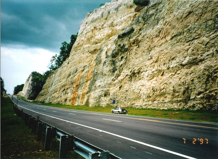
8The base of the Lares Limestone and its contact with the San Sebastián
Formation is exposed at the intersection of the Highways PR10 and PR6621 (Fig.
5) (N18o18’52”, W66o41’05”). In this area, the San Sebastián Formation consists of
poorly consolidated sandstone, siltstone, and conglomerate composed of well-
rounded particles ranging from pebbles to cobbles (Fig. 6). Beds of lignite or
carbonaceous clays are also present.
The top of the San Sebastián Formation contains abundant trace fossils in
the form of burrows that have been filled with the limestone material from the
overlying Lares Limestone. In this area the contact between the two units is
sharp but undulatory (Fig. 7). At the contact, the base of the Lares Limestone
consists of fossiliferous limestones with a high content of fine to medium sand
grains composed mostly of quartz and weathered volcanic rock. The
fossiliferous limestones in this area are composed mostly of grainstones with
Lepidocyclina foraminifers, red algae, rhodolites and echinoderms. Cobbles of
weathered (oxidized) volcanic rocks are aligned in a linear layer 0.6 m above the
contact and follow the apparent dip of the Lares Limestone beds (Fig. 8). A
singular significant depositional event seems to be suggested by the presence of
this layer of oxidized volcanic cobbles.
The Lares Limestone is 17.8 m thick in this exposure. The unit is reported
to reach a maximum thickness of 310 m in the Bayaney quadrangle but in the
Utuado and Florida quadrangles it becomes thin and even absent (Monroe,
1980a; Fig. 4). This change in thickness is the result of the presence of a
topographic high in the area composed of basement rocks of Cretaceous age
(Monroe, 1980a) and San Sebastián Formation rocks (Ramírez-Martínez, 2000).
9The contact between the Lares Limestone and Montebello Member units is
subtle in the Utuado quadrangle but a change in lithologic character between the
units was recognized by Nelson and Monroe (1966) in the Florida quadrangle.
The division between stratas was defined by the presence of a bed 1 to 3 m thick
composed mainly of 5 to 10 cm oysters, probably Ostrea haitensis (Nelson and
Monroe, 1966; Monroe, 1980a). This oyster layer, at the basal Montebello
Member, is readily identifiable throughout the studied area and was used to
define the Lares Limestone-Montebello Member contact (Figs. 5 & 9).
Along PR10 the Montebello Member unit was measured to be 305 m thick
(Ramírez-Martínez, 2000). Monroe (1980a) stipulated that the fullest
development of the Montebello Member is near the Río Grande of Arecibo and
estimated the unit to be about 200 m thick in the area. Ramírez-Martínez (2000)
showed the unit is over 100 m thicker than previously estimated by Monroe.
The Montebello Member consists mostly of repetitions of coral-dominated
boundstones and foraminifer-, mollusks-, red algae- and rhodolite-dominated
packstones (Ramírez-Martínez, 2000). The top of the Montebello Member at
PR10 was mapped at an erosional surface located at N18o23’33”, W66o41’42”, in
front of the first scenic overlook from Arecibo to Utuado (Fig. 10). Above this
erosional surface, starting at 10.5 m above the road, there is a bed 0.5 m thick that
is packed with gastropods (Fig. 11). These gastropods were identified as
belonging to the genera Pomacea and Physa (Fig. 12) (Galluzzo, personal
communication, 1998). Both genera are freshwater taxa with no tolerance for
salinity and are very common in freshwater units of Tertiary age throughout the
Caribbean (Vokes, personal communication, 1998).
10Below the highly fossiliferous bed there are units composed of
carbonaceous clays intercalated with highly brecciated units. The units are
separated by undulatory contacts with pinching out beds. One of these units has
elongate structures that look like rhizoliths (Fig. 13). Large meter-scale circular
cavities filled with fine carbonaceous mud and carbonate breccias are also
present in the outcrop and probably represent solution collapse associated with
subaerial exposure (Fig. 14).
Dolomite was not found in any of the units measured along the PR10
Highway. The rocks of the Lares Limestone and Montebello Member along PR10
consist mostly of pure limestones with small amounts of terrigenous materials
scattered throughout the section.
Interpretations
In the San Sebastián Formation-Lares Limestone contact exposed at the
intersection of the highways PR10 and PR6621 (see Figs. 5, 6 & 7) the upper San
Sebastián Formation character suggests fluvial influences and shallow water.
Fossils of marine or estuarine environments were not present in the section, but
beds of lignite or carbonaceous clays were observed. Graham and Jarzen (1969)
sampled five beds of lignite in the Highway 111 (51,860 N., 105, 150 E., San
Sebastián Quadrangle) southwest of the PR10 Highway contact. These samples
were 21 m below the Lares Limestone- San Sebastián Formation contact. Graham
and Jarzen (1969) reported that pollen from the mangrove Rhizophora makes up
61-77 percent of the samples from the lignite beds. Other lignites samples
collected in the same area showed dicotyledons considered by Hollick (1928) to
11be typical of a tropical environment generally near lagoons or estuaries in which
brackish water was present.
The grainstones present at the base of the Lares Limestone along PR10
Highway as well as the presence of lignite beds, suggest deposition close to the
shore in shallow water.
There is little change in lithology across the Lares Limestone- Montebello
Member contact on PR10, but a few meters below the contact the upper Lares
Limestone section shows two episodes of high terrigenous input. This may
indicate a relatively lower sea-level during the deposition of the upper Lares
Limestone in the area. Ward et al. (2002) also called for a sea-level fall during the
deposition of the upper Lares Limestone.
All the lithofacies studied in Montebello Member section along PR10
Highway suggest deposition in shallow-marine environments. Variations in
fossil content and lithology could have been produced by either progradation of
the shelf or subtle changes in water depth. The Montebello Member section
along PR10 Highway probably was deposited in middle-shelf environments.
Sequence Stratigraphy
In the Lares Limestone and Montebello Member, the fossils are mostly
shallow-water forms with fairly wide stratigraphic ranges (Seiglie and Moussa,
1984; Hartley, 1989; Scharlach, 1990; Todd, 1996; Ramírez, 2000 and Ward et al.,
(2002), among others. This makes high-resolution biostratigraphy a difficult if
not impossible task. The sedimentary section, however, can be subdivided into
major packages that can be chronostratigraphically related based on the concepts
12of sequence stratigraphy (Mitchum et al., 1977). These packages or depositional
sequences are considered genetically related and are separated by sequence
boundaries consisting of unconformities or their correlative conformities
(Mitchum et al., 1977). The Oligocene and Miocene sedimentary rocks (San
Sebastián Formation throughout Aymamón Limestone) have been divided into
five major depositional sequences by Ward et al., (2000, Fig. 15).
The exposure surface located right at the top of the Montebello Member
on the PR10 Highway supports the third sequence boundary proposed by Ward
et al. (2002). They also proposed a second sequence boundary based on a
widespread oyster bed that “suggests” a relative drop in sea level. The oyster
bed was found to be present in the study area and serves as a marker between
the Lares Limestone and Montebello Member and supports the second sequence
boundary proposed by Ward et al. (2002).
The presence of this two sequence boundaries indicates that the Lares
Limestone and the Montebello Member were exposed to weathering, erosion and
meteoric water invasion twice before the undifferentiated Cibao Formation was
deposited over them. This has important stratigraphic, diagenetic, and
hydrological implications for the units involved. First, the units were probably
stratigraphically thicker than today since material was lost due to weathering
and erosion as well as to compaction. Second, the porosity and permeability
character of the units must have change significantly during exposure. Third, an
unconfined aquifer system could have been developed during the exposure in
these units since the San Sebastián Formation, at the bottom of the section, acts as
a hydrologic barrier.
13Conclusions
An exposed section of the Montebello Member of the Cibao Formation in
PR10 Highway from Arecibo to Utuado revealed cyclicity in the distribution
patterns of coral-dominated, mollusks-dominated, foraminifers-dominated, and
red algae/rhodolite-dominated units (Galluzzo and Ramírez, 1998). Tectonic
activity, high-order sea-level fluctuations or progradation across the gently
dipping carbonate platform are proposed as possible causes for the cyclicity
(Galluzzo and Ramírez, 1998).
Indications of relative changes in sea level were detected. The San
Sebastián Formation-Lares Limestone contact suggest a trangressional surface.
Both, an oyster layer at the base of the Montebello Member and a freshwater
gastropods layer 0.5 m above the top of the Montebello Member suggest
subaerial exposures are present during the history of the units (regresional
surfaces).
The setting for the Lares Limestone and Montebello Member often has
been described as a gently dipping carbonate platform (Scharlach, 1990; Frost et
al., 1983; Seiglie and Moussa, 1984; Hartley 1989; Ward et al., 1990; Todd, 1996;
Ramírez-Martínez 2000, and Ward et al., 2002, among others). The study of the
exposures on PR10 Highway supports this conclusion. Terminology relating
lithofacies to reef-rimmed platform environments should be avoided since there
is no evidence for shelf-brake reef tracts which would have created these
environments (Galluzzo and Ramírez, 1998; Ramírez Martínez 2000; and Ward et
al., 2002.
14Field Trip Stops
Stop 1 - Figures 5, 6, 7, 16, and 17
Lares Limestone - San Sebastián Formation Contact
Intersection of the Highway PR10 and road PR6621
(Western side of the intersection)
N18o18’52”, W66o41’05”
The top of the San Sebastián Formation contains abundant trace fossils in
the form of burrows that have been filled with the limestone material from the
overlying Lares Limestone. In this area the contact between the two units is
sharp but undulatory (see Fig. 7). At the contact, the base of the Lares Limestone
consists of fossiliferous limestones with a high content of fine to medium sand
grains composed mostly of quartz and weathered volcanic rock. The
fossiliferous limestones in this area are composed mostly of grainstones with
Lepidocyclina foraminifers, red algae, rhodolites and echinoderms. Cobbles of
weathered (oxidized) volcanic rocks are aligned in a linear layer 0.6 m above the
contact and follow the apparent dip of the Lares Limestone beds (Fig. 8). A
singular significant depositional event seems to be suggested by the presence of
this layer of oxidized volcanic cobbles.
The Lares Limestone is 17.8 m thick in this exposure. The unit is reported
to reach a maximum thickness of 310 m in the Bayaney quadrangle but in the
Utuado and Florida quadrangles it becomes thin and even absent (Monroe,
1980a; Fig. 4). This change in thickness is the result of the presence of a
topographic high in the area composed of basement rocks of Cretaceous age
(Monroe, 1980a) and San Sebastián Formation rocks (Galluzzo and Ramírez,
1998; Ramírez-Martínez 2000).
15Stop 2 - Figures 9, 17, 18, and 19
Montebello Member – Lares Limestone Contact
Oyster Layer Unit
Intersection of the Highway PR10 and road PR6621
(Eastern side of the intersection)
N18o18’58”, W66o40’51”
The contact between the Lares Limestone and Montebello Member units is
subtle in the Utuado quadrangle but a change in lithologic character between the
units was recognized by Nelson and Monroe (1966) in the Florida quadrangle.
The division between stratas was defined by the presence of a bed 1 to 3 m thick
composed mainly of 5 to 10 cm oysters, probably Ostrea haitensis (Nelson and
Monroe, 1966; Monroe, 1980a). This oyster layer, at the basal Montebello
Member, is readily identifiable throughout the studied area and was used to
define the Lares Limestone-Montebello Member contact (Fig. 9 & 18).
Stop 3 - Figures 17, 20, and 21
Montebello Member – Jobos Formation Contact
At the intersection of the Highway PR10 and road PR621
N18o19’58”, W66o40’42”
At this stop the Montebello Member is in contact with the Jobos Formation
(Upper Paleocene to Middle Eocene, mostly volcanic breccia, includes some
conglomerate, volcanic sandstone, and lava 1,700m). The contact is undulatory
with multiple truncations (Figs. 20 & 21). The Lares Limestone is absent here due
to the former presence of a topographic high in the area composed of basement
rocks of Cretaceous age (Monroe, 1980).
16Stop 4 - Fig. 17
Montebello Member / Coral Boundstone
2nd Obervation Mogote north of theHighway
PR10 - PR621 road intersection
N18o19’58”, W66o40’42”
Recrystalized corals in growth position and surrounded by wackestones
are abundant in the area. This unit is equivalent stratigraphically to the Head
Coral- Boundstone present at the top of the outcrop visited in Stop 1.
Stop 5 - Fig. 17
Montebello Member / Stlylophora Boundstone
N18o20’15”, W66o40’35”
This is the only lens-like structure found in the whole PR10 Highway
section. It is composed of the branching coral (Stylophora) and surrounded by a
groundmass of red algal packstones and grainstones.
Stop 6 - Fig. 17
Montebello Member / Porites Boundstone
PR10 Km 70.5
The branching coral Porites is extremely abundant and seems to be in
growth position. This unit is equivalent stratigraphically to the Branching Coral-
Boundstone present at the top of the outcrop visited at Stop 1.
Stop 7 - Fig. 17
Montebello Member / Miocerites Packstone
17N18o21’06”, W66o41’12”
The study of the exposed section of the Montebello Member of the Cibao
Formation in the new PR10 Highway from Arecibo to Utuado revealed cyclicity
in the distribution patterns of coral-dominated, mollusks-dominated,
foraminifers-dominated, and red algae/rhodolite-dominated units (Galluzzo and
Ramírez, 1998). Here we have one of the multiple foraminifers-dominated
packstones present in the section. The foram genus Miocerites is dominant.
Oysters and equinodems are also common.
Stop 8 - Fig. 17 and 22
Montebello Member / Grainstone – Submarine Hardground.
N18o21’12”, W66o41’12”
A 0.5 meter thick grainstone unit with abundant rhodolites, equinoderm
fragments and spicules forms a sharp, linear, well defined bed in this area. The
geometry of the bed, texture, and petrography suggest that this unit could have
been a submarine hardground at some moment during the deposition of these
rocks.
Stop 9 - Fig. 17, 23 and 24
Montebello Member / Ancient Water Table or Exposure ?
N18o22’17”, W66o41’39”
A bed of carbonaceous clays is present in between the fossiliferous
limestones in this outcrop. This highly undulatory bed is not associated with
18calishe layers, brackish or freshwater fossils, nor it has any other feature that
would suggest that it was formed by subaerial exposure. Several possible
explanations could be suggested to explain the formation of this atypical bed in
the area. Diagenetical explanations seem more feasible than depositional. One
possibility is that this layer could have mark the position of the air-water
interface (water table) present in the area at some moment in time.
Stop 10 - Fig 17, 24, 25 and 27
Grainstone layer with abundant Kupus incrassatus in growth
position
N18o22’47”, W66o41’56”
The Kuphus belong to the super family Pholadacea, suborden, Dufinae,
Orden Myoida, suborden Proladina, familia Teredinidae, subfamilia Kuphinae
(Moore, Editor (n) Mollusca, 62003 1969). The Kuphus have an elongated tube that
is mostly composed of low magnesian calcite (Fig. 27). The animal produces
secretions of calcite for the protection of depredators. Most characteristic is the
presence, in the upper smaller end of the tube, of two small tubes, one slightly
larger than the other, that are encased in an extensive development of
supplementary calcareous deposit (Vokes Tulane University). The smaller
tubes house the inhalant and exhalent siphons of the animal, the one for the
inhalant siphon being somewhat larger diameter than that for the exhalent one
(Vokes Tulane University). Kuphus tubes are common in the North Coast
Limestones and are composed of low magnesian calcite (high potential
preservation). Sr isotopes have been used to obtain dates of fossils shells
19composed of low magnesium calcite based on well documented variations of Sr
isotopes in marine water through geologic time. The former method can be
applied to the Kuphus incrasautus tubes since they are made of low magnesium
calcite. "Absolute ages" of the Kuphus tubes can help approximate the "absolute
age" when a Limestone was being formed. This "absolute age" information can
probably help to establish a better stratigraphic chronology of the Puerto Rico
Tertiary Limestones providing that the Kuphus tubes have not being altered.
Ramírez-Martínez et al. (2006 and 2008) has demonstrated they are a promising
prospect to establish absolute dates along the North Coast Limestones
Stop 11 - Fig. 18 and 26
Top of Montebello Member
Exposure ! (Paleosoils/Roots/Paleokarst/Freshwater Gastropods)
N18o22’52”, W66o41’16”
The top of the Montebello Member at PR10 was mapped at an erosional
surface located at N18o23’33”, W66o41’42” (in front of the first scenic overlook
from Arecibo to Utuado). Above this erosional surface, starting at 10.5 m above
the road, there is a bed 0.5 m thick that is packed with gastropods (Fig. 26).
These gastropods were identified as belonging to the genera Pomacea and Physa
(Fig. 12) (Galluzzo, personal communication, 1998). Both genera are freshwater
taxa with no tolerance for salinity and are very common in freshwater units of
Tertiary age throughout the Caribbean (Vokes, personal communication, 1998).
Below the highly fossiliferous bed there are units composed of
carbonaceous clays intercalated with highly brecciated units. The units are
separated by undulatory contacts with pinching out beds. One of these units has
20elongate structures that look like rhizoliths. Large meter-scale circular cavities
filled with fine carbonaceous mud and carbonate breccias are also present in the
outcrop and probably represent solution collapse associated with subaerial
exposure (Figs. 13, 14 & 26).
References
BERKEY, C. P., 1915, Geological reconnaissance of Porto Rico: New York Academy of
Science Annals, v. 26, p. 1-70.
BERKEY, C. P., 1919, Introduction to the geology of Porto Rico: New York Academy of
Science Survey of Puerto Rico and the Virgin Islands, v. 1, pt. 1, p. 11-29.
BRIGGS, R. P., 1961, Geology of Kewanee Interamerican Oil Company test well
number 4-CPR, northern Puerto Rico; in: Oil and gas possibilities of northern Puerto
Rico: Puerto Rico Mining Commission, p. 123.
FROST, S. H., HARBOUR, J. L., BEACH, D. K., REALINI, M. J., AND HARRIS, P.
M., 1983, Oligocene reef tract development southwestern Puerto Rico: Sedimenta IX,
p. 144 .
GALLUZZO, J. J., AND RAMÍREZ, W., 1998, Surface expression of cyclicity and
biofacies transitions in the Middle Tertiary Lares and Montebello Limestones,
northern Puerto Rico: A.A.P.G. Abstracts with Programs , v. 1998 A.A.P.G.
convention in Houston, TX, p. 1.
HARTLEY, J. R., 1989, Subsurface Geology of the Tertiary carbonate rocks,
northwestern Puerto Rico: [unpub. M.S. thesis]: University of New Orleans, p. 214.
HEISEL, J. E., GONZALEZ, J. R., AND CRUZ, C., 1983, Analog model analysis of the
north coast limestone aquifers, Puerto Rico: U.S.G.S. Open File Report, 82-52, p. 49.
HOLLICK, A., 1928, Paleobotany of Porto Rico: New York Acad. Sci., Sci. Survey
Porto Rico and the Virgin Islands, v. 7, pt. 3, p. 177-393.
HUBBARD, B., 1920, The Tertiary Formations of Porto Rico: G.S.A. Bull, v. 31, p. 135.
-------, 1923, The Geology of the Lares District, Porto Rico: New York Academy of
Science, v. 2, p. 1-115.
21MEYERHOFF, H. A., 1975, Stratigraphy and petroleum possibilities of Middle Tertiary
Rocks in Puerto Rico: discussion: A.A.P.G., v. 59, p. 169-172.
MEYEROHOFF, A. A., KRIEG, E. A., CLOOS, J. D., AND TANER, I., 1983,
Petroleum potential of Puerto Rico: Oil and Gas Journal, v. Dec. 19, p. 113-120.
MITCHUM, R.M. JR., VAIL, P.R. AND THOMPSON, III S., 1977, Seismic stratigraphy
and global changes of sea-level Part 2: The depositional sequence as a basic unit for
stratigraphic analysis. In: Seismic Stratigraphy -Applications to Hydrocarbon
Exploration (Ed. By C.E. Payton), Mem. Am. Ass. Petrol. Geol., v. 26. p. 53-62.
MONROE, W. H., 1963a, Geology of the Camuy quadrangle, Puerto Rico: U.S.G.S.
Quadrangle Map GQ-197.
-------, 1968, The Aguada Limestone of northwest Puerto Rico: U.S.G.S. Bull, Bull 1274-
G, p. G1-G12.
-------, 1973, Stratigraphy and petroleum possibilities of Middle Tertiary rocks in Puerto
Rico, reply to discussions: A.A.P.G., v. 57, 6, p. 1086-1099.
-------, 1980a, Geology of the Middle Tertiary Formations of Puerto Rico: U.S.G.S.
Professional Paper, 953, p. 93.
NELSON, A. E, AND MONROE, W. H., 1966, Geology of the Florida Quadrangle,
Puerto Rico: U.S.G.S. Bull, 1221-C, p. 22.
RAMÍREZ-MARTÍNEZ, W., 2000, Dolomitization and Evolution of the Puerto Rico
North Coast Confined Aquifer System, unpublished Ph.D. Thesis, Tulane University,
New Orleans, Louisiana, 338 pp.
RAMÍREZ, WILSON R.; JOHNSON, CLAUDIA C.; MARTÍNEZ, MICHAEL;
TORRES, MARIA DEL CARMEN; AND ORTÍZ, VERONICA (2006) Strontium
Isotope Stratigraphy from Kuphus Incrassatus, Cenozoic Limestones, Puerto Rico,
Abstract in GSA Annual Meeting, Abstracts with Program, Vol. 39, No. 7, p.90.
RAMÍREZ-MARTÍNEZ, WILSON R.; JOHNSON, CLAUDIA; MARTÍNEZ,
MICHAEL; TORRES, MARÍA DEL C.; ORTÍZ VERÓNICA, AND VÉLEZ JORGE
(2008). Strontium Isotope Stratigraphy from Kuphus Incrassatus, Cenozoic
Limestones, Puerto Rico Abstract in: 18va Conferencia de Geología del Caribe
Programa y Resúmenes, , Santo Domingo, República Dominicana, page 59.
RENKEN, R., WARD, W.C., GILL, I.P., GÓMEZ-GÓMEZ, F., RODRÍGUEZ-
MARTÍNEZ, and others, 2002, Geology and Hydrogeology of the Caribbean-Islands
Aquifer System of the Commonwealth of Puerto Rico and the U.S. Virgin Islands:
U.S. Geological Survey Professional Paper 1419, 139 pp.
22SCHARLACH, R. A., 1990, Depositional history of Oligocene-Miocene carbonate rocks,
subsurface of northeastern Puerto Rico: [unpub. M.S. thesis]: University of New
Orleans, p. 242.
SEIGLIE, G. A., AND MOUSSA, M. T., 1975, Paleoenvironments of Quebradillas
Limestone (Tertiary), northern Puerto Rico, and their geologic significance: A.A.P.G.
Bull, v. 59, 12, p. 2314-2321.
-------, 1984, Late Oligocene-Pliocene transgressive-regressive cycles of sedimentation in
northwestern Puerto Rico: in Schlee, J. S., ed., Interregional unconformities and
hydrocarbon accumulation: A.A.P.G. Memoir, 36, p. 89-96.
TODD, P. C., 1996, Lithology and depositional history of the Oligocene-Miocene section
in two wells in northern Puerto Rico: [unpb. M.S. thesis]: University of New Orleans,
p. 74 plus appendixes.
WARD, W. C, Scharlach, R. A., and Hartley, J.R., 2002 , Geology of the North Coast
ground-water province of Puerto Rico. in: Renken R. A., and others, Geology and
Hydrogeology of the Caribbean-Islands Aquifer System of the Commonwealth of
Puerto Rico and the U.S. Virgin Islands: U.S. Geological Survey Professional Paper
1419. 139 pp.
ZAPP, A. D., BERQUIST, H. R., AND THOMAS, C. R., 1948, Tertiary geology of the
coastal plains of Puerto Rico: U.S.G.S. Oil and Gas Investigation Preliminary Map
85.
23You can also read