The SASSCAL / MAWF Weather Stations Network in Namibia - Overview of equipment and data transfer
←
→
Page content transcription
If your browser does not render page correctly, please read the page content below

The SASSCAL / MAWF Weather Stations
         Network in Namibia
   Overview of equipment and data transfer

              Report compiled by Dr B. Strohbach

        School of Natural Resources and Spatial Sciences
                    Polytechnic of Namibia
                          P/Bag 13388
                           Windhoek

                         October 2014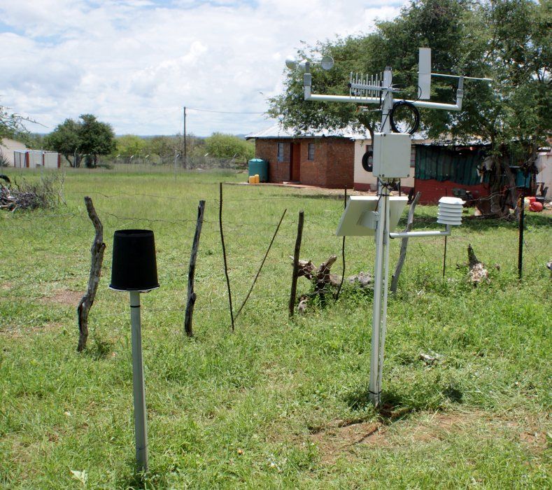
1.   Contents
2.        Background....................................................................................................................... 2
3.        Type of equipment employed .......................................................................................... 2
          Mike Cotton Systems ....................................................................................................... 2
          Campbell Scientific / Young.............................................................................................. 5
4.        Network............................................................................................................................ 8
5.        Communication .............................................................................................................. 11
          MCS130 Logger............................................................................................................... 12
          Campbell CR1000 logger ................................................................................................ 12
          Communication via GPRS-network ................................................................................ 12
          Communication via satellite........................................................................................... 15
          SASSCAL WeatherNet Website ...................................................................................... 15
6.        Planned activities and methodological approaches....................................................... 15
          Subtask 1: Site selection, erecting new stations............................................................ 15
          Subtask 2: Maintenance of the stations......................................................................... 15
          Subtask 3: Making data available to end-users.............................................................. 15
7.        References and further reading ..................................................................................... 16

                                                                1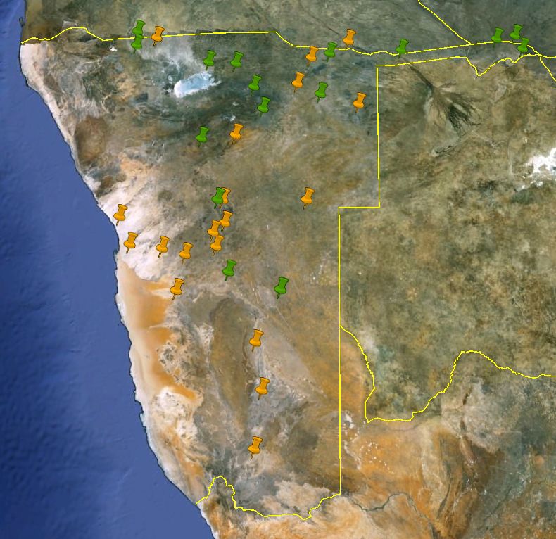
2.       Background
Through the BIOTA project (2000 - 2009) 21 high end weather stations meeting WMO standards have
been bought for deployment in Namibia. Some of these stations are replacing older equipment at
the BIOTA observatories (Jürgens et al., 2010), while some are / will be placed in new strategic
localities. These 21 stations update their readings hourly on the web via the cell network or satellite
communication. The Ministry of Agriculture, Water and Forestry (MAWF) supported this project with
17 Automatic Weather Stations (AWS) on their research stations. In addition, 14 other weather
stations of different technical standard are currently operated by private individuals and primarily
tourism lodge operators across the country. Data from these stations is displayed on the web under
the Namibia Weather Network. The Namibia Meteorological Service runs a number of automatic and
manual weather stations. The World Meteorological Organizations lists 127 rainfall stations for
Namibia.

3.       Type of equipment employed
Two types of weather stations are currently in use:

Mike Cotton Systems
These stations are build and sold by the Company Mike Cotton Systems in Cape Town, South Africa
(see www.mcsystems.co.za for details). These stations were initially installed at the BIOTA
observatories in 2001. The logger had a capacity of storing data for about 6 months, but no capacity
to download data via the cellphone network. Thus a 3-monthly routine was developed to visit the
stations and manually download the data. Later models (from 2007 onwards) of the logger were
equipped with a cellphone logger, enabling us to have the data download via the cellphone (GSM /
GPRS) network. The buffer size, however, was reduced, allowing the station to only store data up to
8 weeks (not quite 2 months).

The stations were mounted on a 2 m pole (Figure 1), and equipped as follows (Table 1).

Table 1: Typical configuration of the Mike Cotton System AWS's used during the BIOTA project, and
later by the Ministry of Agriculture, Water and Forestry.

                                   Model                              Installation notes

Logger                             MCS130 10-channel logger

Power supply                       6 V rechargeable lead-acid         The initial system (without
                                   battery, recharged via the         cellphone modem) worked on a
                                   logger from a solar panel          3.6 V lithium battery, which was
                                                                      not recharged. Battery lifetime
                                                                      was at least 3 years.

Wind speed                         MCS177                             2 m above ground level

Wind direction                     MCS176                             2 m above ground level

Sunshine duration, intensity       MCS155                             2 m above ground level

Air temperature                    MCS151                             1.5 / 2 m above ground level, in

                                                  2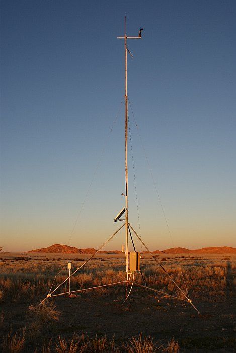
a radiation shield*

Air relative humidity              MCS174 or Vaisala                   1.5 / 2 m above ground level, in
                                                                       a radiation shield *

Rainfall                           Davis raingauge                     1.5 m above ground level, on
                                                                       own stand next to (ca 2 - 3 m
                                                                       away from) main station

Soil temperature                   MCS151S                             10 cm below ground

Leaf wetness                                                           2 m above ground level

Air pressure                       MCS157                              In logger box, ca 1.6 m above
                                                                       ground. Only installed
                                                                       retrospectively from 2010
                                                                       onwards

* The installation of the air temperature sensors was originally at 1.5 m height, and only later
adjusted to the required 2 m above ground level.

The Ministry of Agriculture, Water and Forestry bought 16 similar stations, but installed these on a
10 m pole (Figure 2). This allowed them to install the wind speed and direction sensors at the
required height of 10 m above ground level. The Pyrometer (Sunshine intensity) was also installed at
that height. The GSM antenna (Yagi-type antenna) and the solar panel were installed 7 m above
ground, to have a better reach (GSM network) or be out of reach of vandalism / thieves (solar panel).
The Yagi-antenna is said to have a reach of up to 50 km, depending on topography and placement of
base station.

Advantages of the MCS-stations:

a) cheap

b) Build in South Africa, spare parts thus readily available, not directly dependant on exchange rate
fluctuations

b) easy to install, with sensors being linked to logger with a normal RS11 jack (telephone jack).

Disadvantages of the MCS-stations:

a) Limited adaptability

b) Only sends out data, not able to address logger remotely

c) Sensitivity of logger to nearby lightning strikes (changes date settings on logger, making the
receiving of data difficult)

d) Data is sent out to a proprietary IP, linked to the manufacturer's internet server. Creates a certain
dependability on the manufacturer for data transmission

e) Resetting can only be achieved by undoing the power supply.

                                                   3
Figure 1: Typical MCS-station, here with Yagi-antenna and solar panel, at Okamboro outside
Okahandja.

                                            4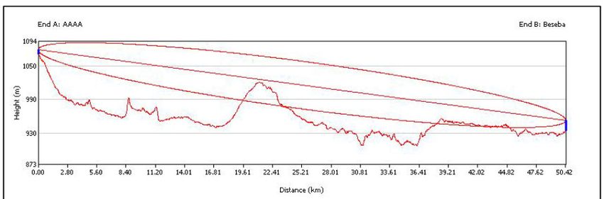
Figure 2: Modified MCS-station as used by the MAWF, on a 10 m pole. This allows the station to fulfil
WMO standards. This station is at Kalimbeza in the Zambezi region.

Campbell Scientific / Young
At the end of the BIOTA project, remaining funds were invested in the purchase of high-quality
weather stations to replace the aging MCS-stations. One of the targets was to provide a long-term
solution to climatic data without a continuous need to replace sensors or to download data. The AWS
were to conform with WMO standards, and were meant to provide data for numerous follow-up
projects after BIOTA (including SASSCAL). SASSCAL Task 001 is building on this particular set of
weather stations in Namibia, and is expanding the station network in the neighbouring countries of
Angola, Zambia and Botswana.

A combination of a Campbell CR1000 logger (see www.campbellsci.com), with a range of Young
sensors (see www.youngusa.com), was installed (Table 2).

                                                 5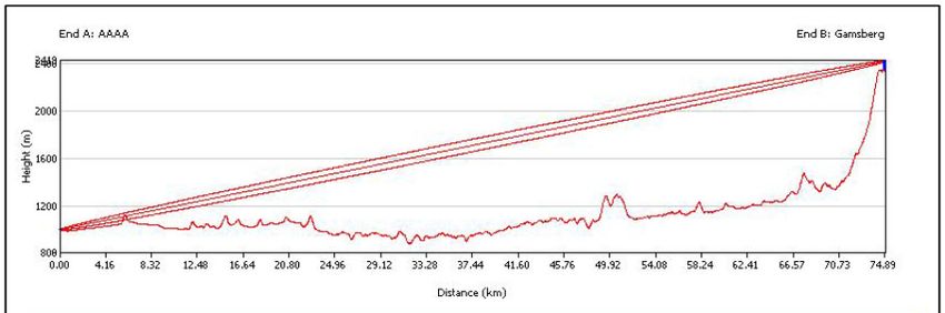
Table 2: Typical configuration of a Campbell / Young station, as installed at the end of the BIOTA
project and presently used by the SASSCAL project.

                                 Model                            Installation notes

Logger                           Campbell CR1000

Power supply                     12 V rechargeable lead-acid      Initially the solar panel was
                                 battery, recharged via a         installed at 4m height for easy
                                 regulator from a solar panel     cleaning, and not to interfere
                                                                  with the pyrometer (installed
                                                                  above it). After several theft
                                                                  cases, these were placed at 7 m
                                                                  height.

Communication                    Siemens MC35i Terminal           This modem can be replaced by
                                 Cellular Engine                  a satellite communication
                                                                  modem. Tests are currently
                                                                  underway with Meteosat
                                                                  modems
Wind speed                       Young Model 05103                Combination sensor, installed
                                                                  10 m above ground level
Wind direction

Sunshine duration, intensity     Envco WE300 Solar Radiation      4 m above ground level. No
                                 Sensor?                          exact details available on
                                                                  model.

Air temperature                  Young Model 41382                Combination sensor, installed
                                                                  2 m above ground level, in a
Air relative humidity                                             radiation shield

Rainfall                         Young Model 52202                1.5 m above ground level, on
                                                                  own stand next to (ca 2 - 3 m
                                                                  away from) main station

Soil temperature                                                  10 cm below ground. No exact
                                                                  details available on model.

Leaf wetness                     Decagon Devices LWS              Initially placed near ground
                                                                  level in some vegetation, but
                                                                  presently standardized at 2 m
                                                                  above ground level

Air pressure                     Young Model 61302                In logger box, ca 1.6 m above
                                                                  ground.

                                                6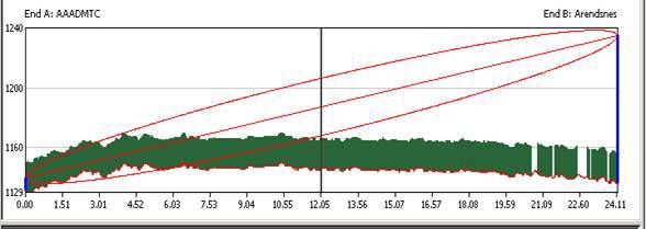
Figure 3: View inside the Campbell / Young Logger enclosure.

Advantages of Campbell / Young Stations:

a) Highly versatile, programmable logger

b) Through a fixed IP address, the logger can be addressed remotely via the GPRS network. This
   allows for regular downloads of data from "difficult" stations, update of software, resetting of
   loggers, etc.

c) The loggers can be individually reprogrammed to take additional sensors for specific purposes
   (not unlimited, though).
                                                 7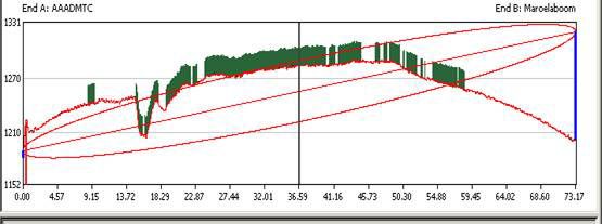
d) Highly accurate, well-calibrated sensors

Disadvantages of Campbell / Young Stations:

a) Very expensive system

b) As all parts are imported, spare parts are not readily available in southern Africa, requiring a
   delivery time of up to 2 months.

c) Installation is difficult, as sensors need to be individually wired and the wires individually
   attached to the logger unit. This already led to thousands of dollars damage due to wrong wiring.

4.       Network
The SASSCAL / MAWF automated weather station network presently consists of 38 stations in
Namibia (Table 3). Their positions are illustrated in Figure 4.

Table 3: AWS’s forming part of the SASSCAL / MAWF weather station network in Namibia. Stations
which were part of the original BIOTA-network (2001 - 2009) are shaded in green.

Station name        Position            Nearest Town,         Make                 Owner
                    (Lat / Long)        Region

Mahenene            -17.444333°S,       Outapi, Omusati       MCS, 10 m tower      MAWF (DART)
                    14.784806°E

Kalimbeza           -17.555833°S,       Katima Mulilo,        MCS, 10 m tower      MAWF (DART)
                    24.521667°E         Zambezi

Sachinga            -17.673333°S,       Katima Mulilo,        MCS, 10 m tower      MAWF (DART)
                    24.031667°E         Zambezi

Ogongo              -17.678528°S,       Ogongo, Omusati       Campbell / Young, SASSCAL
                    15.294806°E                               10 m tower

Oshaambelo          -17.842861°S,       Outapi, Omusati       MCS, 10 m tower      MAWF (DART)
                    14.770083°E

Mashare             -17.8946°S,         Mashare, Kavango      Campbell / Young, SASSCAL
                    20.2085°E           East                  10 m tower

Ngoma               -17.900278°S,       Katima Mulilo,        MCS, 10 m tower      MAWF (DoF)
                    24.706944°E         Zambezi

Bagani              -18.094639°S,       Divundu, Kavango      MCS, 10 m tower      MAWF (DART)
                    21.559972°E         East

Hamoye              -18.23475°S,        Rundu, Kavango        MCS, 10 m tower      MAWF (DoF)
                    19.732306°E         West

                                                 8
Alex Muranda    -18.3643°S,     Kavango West         Campbell / Young, SASSCAL
                19.2562°E                            10 m tower

Okashana        -18.411111°S,   Omuthiya,            MCS, 10 m tower   MAWF (DART)
                16.638528°E     Oshikoto

Okapya          -18.4725°S,     Oshivelo, Oshikoto   MCS, 10 m tower   MAWF (DART)
                17.339083°E

Sonop           -19.0101°S,     Grootfontein,        Campbell / Young, SASSCAL
                18.9039°E       Otjosondjupa         10 m tower

Mannheim        -19.168611°S,   Tsumeb, Oshikoto     MCS, 10 m tower   MAWF (DART)
                17.763056°E

Tsumkwe         -19.6156°S,     Tsumkwe,             Campbell / Young, SASSCAL
                20.442°E        Otjosondjupa         10 m tower

John Pandeni    -19.707778°S,   Grootfontein,        MCS, 10 m tower   MAWF (DART)
                18.035°E        Otjosondjupa

Waterberg       -20.3971°S,     Okakarara,           Campbell / Young, SASSCAL
                17.3529°E       Otjosondjupa         10 m tower

Omatjenne       -20.442667°S,   Otjiwarongo,         MCS, 10 m tower   MAWF (DART)
                16.493472°E     Otjosondjupa

Okomumbonde     -20.483278°S,   Okakarara,           MCS, 10 m tower   MAWF (DART)
                17.343167°E     Otjosondjupa

Omatako Ranch   -21.5094°S,     Okahandja,           Campbell / Young, MAWF (DART)
                16.7291°E       Otjosondjupa         10 m tower

Erichsfelde     -21.5986°S,     Okahandja,           Campbell / Young, SASSCAL
                16.9012°E       Otjosondjupa         10 m tower

NFRC            -22.005639°E,   Okahandja,           MCS, 10 m tower   MAWF (DoF)
                16.917972°E     Otjosondjupa

Okamboro        -22.009494°S,   Okahandja,           MCS, 2 m*         SASSCAL
                17.041386°E     Otjosondjupa

Sandveld        -22.0445°S,     Gobabis, Omaheke     Campbell / Young, SASSCAL
                19.1321°E                            10 m tower

Wlotskasbaken   -22.3149°S,     Wlotskasbaken,       Campbell / Young, SASSCAL
                14.4621°E       Erongo               10 m tower

NBRI            -22.5707°S,     Windhoek, Khomas     Campbell / Young, SASSCAL

                                        9
17.0957°E 10 m tower
NBRI2 -22.57238°S, Windhoek, Khomas Campbell / Young, SASSCAL
17.094806°E 10 m tower, with
satellite modem
Claratal -22.7876°S, Windhoek, Khomas Campbell / Young, SASSCAL
16.8144°E 10 m tower
Kleinberg -22.9895°S, Walvis Bay, Erongo MCS, 2 m** SASSCAL
14.728167°E
Ganab -23.1218°S, Erongo Campbell / Young, SASSCAL
15.5383°E 10 m tower
Narais / -23.1301°S, Khomas Campbell / Young, SASSCAL
Duruchaus 16.8849°E 10 m tower
Rooisand -23.294528°S, Khomas MCS, 2 m* SASSCAL
16.114667°E
Tsumis -23.729778°S, Rehoboth, Hardap MCS, 10 m tower MAWF (DART)
17.193861°E
Dieprevier -24.1296°S, Solitaire, Hardap Campbell / Young, SASSCAL
15.8947°E 10 m tower
Kalahari -24.162833°S, Stampriet, Hardap MCS, 10 m tower MAWF (DART)
18.476722°E
Nico -25.341833°S, Mariental, Hardap MCS, 10 m tower SASSCAL
17.853639°E
Gellap Ost -26.4011°S, Keetmanshoop, Campbell / Young, SASSCAL
18.0072°E Karas 10 m tower
Kairos -27.6745°S, Karas Campbell / Young, SASSCAL
17.8195°E 10 m tower
* To be upgraded to a 10 m tower soon
** Due to security reasons, kept at 2 m assembly.
10Figure 4: Distribution of the SASSCAL / MAWF weather stations in Namibia. Orange pins denote
SASSCAL stations, green pins MAWF stations.
5. Communication
The main aim of the SASSCAL weather station network is make climatic data available to a wide
audience of researchers and the general public, as close to real-time as possible. For this reasons.
three criteria are considered in the development of this network:
a) reliable, complete collection of climatic data, without missing data
b) reliable communication of data to a centralised database
c) Immediate release of data via the internet to all interested parties, for free
In order to achieve this, the following communication settings are used in the different loggers:
11MCS130 logger
The MCS130 logger is storing the hourly averaged reading into two buffers: a temporary and a long-
term buffer. Every hour, on the hour, a connection is made to the GPRS network, and the previous
hour's data uploaded as a text string to a receiving IP address. Once a text string is uploaded
successfully, it is cleared from the temporary buffer. Should the modem fail to make a connection, a
series of repeated attempts is made by the logger to connect to the GPRS network and to upload its
data in the temporary buffer - including all data which was previously not uploaded and cleared from
the temporary buffer. The temporary buffer stores data for about two days, after which the oldest
data becomes overwritten by the latest data. The same data is stored in the long-term buffer, which
has a capacity of about two months worth of data. Once the buffer is full, however, data is not
overwritten - the logger keeps the oldest data in it's memory.
The logger is pre-programmed to download data to a specified IP address, making the data available
to a website of the supplier (www.avitrack.co.za). From this server, the data is automatically
forwarded to the SASSCAL server (by special arrangement). A certain dependency to the supplier
however remains.
The MCS130 logger cannot be addressed remotely, making it thus impossible to download data or to
clear data from the buffer remotely. The logger is susceptible to electromagnetic interference from
lightning strikes nearby, which leads to the changing of the logger date or the jamming of the modem
functioning. This leads to interruptions in data delivery (although the data is still stored in the long-
term buffer). For this reason, it is recommended to schedule a field visit to each MCS logger every
two months to (a) download all data from the long-term buffer, (b) clear this buffer, (c) reset the
date and time on the logger if necessary1 and (d) reset / restart the logger if necessary.
Campbell CR1000 logger
The Campbell CR1000 loggers are programmed in a very similar way. The main differences are,
however, (a) that data are directly sent to the SASSCAL server, not to a intermittent server. (b) The
storage capacity of the server is considerably greater - at least 12 months (tested), and (c) the logger
is, via a fixed IP address linked to the SIM card, remotely addressable. The loggers are also (or at least
seem to be) fairly resistant to electromagnetic inference through lightning. The logger has been
programmed to switch off the modem for five minutes every hour on the half hour, in order to
ensure that a good connection to the GPRS network exists once the logger connects at the full hour
to transmit its data.
Communication via GPRS-network
The most cost-effective way of communication is via GPRS-network, offered by both cellular
communications companies in Namibia. However, there are differences in the services offered by the
two companies. The network of MTC is well-established, reaching many of the most remote places,
whereas the network of TN Mobile (formerly Leo) is still being expanded (Figure 5). However, it has
been found that the TN Mobile network works more reliable, and is easier to connect to. For MTC,
SIM's on a special telemetry contract had to be obtained in order to connect to the GPRS network. In
contrast, even TN Mobile's prepaid cards are automatically open to the GPRS network. The cost
implications are huge - with MTC, a monthly contract administration fee needs to be paid, and is
about 3 times more than the actual expenses due to data transfer. In the past we also constantly
1
Care needs to be taken that the logger time is kept to summer time constantly, in order to avoid confusion
and data loss.
12experienced problems with interruptions with the service due to assumed "late" payments - i.e.
payments, which were done in good time, but were not traced by the accountants of MTC in good
time, resulting in the disconnection for a couple of days in service. Queries regarding service
interruptions could not be answered by front-desk staff, and often were unanswered for a number of
days (own experience).
Figure 5: Approximate cellphone coverage by the two cellphone companies in Namibia. Left: MTC,
right: TN Mobile (ex Leo). The TN Mobile network is constantly expanding, though. Source:
www.namibweb.com.
All AWS's are equipped with a high-gain Yagi antenna. The reach of these antennas is said to be
approximately 50 km in line of sight. This holds true for most AWS's, with some notable exceptions
(which I am aware of): Hamoye (sending to Arendsnes BS, 24.1 km) and Gellap Ost (sending to
Berseba BS, 50.4 km) are constantly faced with interruptions. The reasons are not clear - could be
obstructions in the line of sight (Figure 6 a and b). In contrast, Ganab, sending to Gamsberg BS over
74.9 km, has a fairly stable data delivery (Figure 6 c). Due to obstructions, it was decided to not yet
install an AWS at Kanovlei, which would need to send its data to Maroelaboom BS (73.2 km).
Obstructions are likely to occur in this radio path (Figure 6 d). Similar radio path diagrams can be
obtained for any given location from the service providers on request, or, if the base station is
known, obtained with the aid of Google Earth. These diagrams, including some modelling with
Google Earth, help immensely in the planning of the final location of a new AWS.
13a
b
c
d
Figure 6: Radio paths for a number of selected AWS's to the nearest base station (BS). a: Hamoye,
b: Gellap Ost, c: Ganab, d: Kanovlei. These radio path diagrams have been provided by MTC.
14Communication via satellite
The Campbell CR1000 loggers allow also the possibility to communicate via satellite communication,
provided a suitable modem is installed. This possibility allows the installation of AWS’s in locations
outside the present GSM network. The station “NBRI2” is presently a test station, communicating via
the METEOSAT satellite. Exact details on the technology are not available, but this communication
avenue will enable the installation of planned weather stations at Kanovlei, Giribes and Marienfluss.
SASSCAL WeatherNet Website
The data collected by the weather stations is made available on the SASSCAL WeatherNet website
(www.sasscalweathernet.org/index.php). This website also makes data available for collaborating
stations in Angola, Botswana and Zambia. Next to hourly data, daily and monthly summaries are
available and are also downloadable as csv-type files. On request, a daily e-mail is sent out to users,
detailing the daily minimum and maximum temperatures as well as the precipitation during the past
24 hours.
6. Planned activities and methodological approaches
Besides the definition of WMO standard design it will be crucial to develop criteria and a strategy for
the spatial design of the future stations which reflects various scientific requirements, user needs
and technical aspects, also taking into consideration the quality and reliability of the private stations.
The design should equally reflect the regional dimension. Within the frame of the SASSCAL initiative,
the following tasks are planned.
Subtask 1: Site selection, erecting new stations
Within the first year, the final site selection needs to be accomplished. This will be done specifically
considering the needs of both the bush encroachment project (task 73) as well as the Biodiversity
Observation network (task 159). Additional factors to take in account are needs by especially climate
modellers (task 6) as well as other research initiatives within the MAWF in need of good quality
climatic data.
Subtask 2: Maintenance of the stations
Regular maintenance trips to all stations are planned, as well as ad hoc trips to stations which show
problems with specific sensors. The purpose of these trips is to have a continuous stream of good
quality climatic data, with as little gaps as possible.
Within this project, we want to target especially forestry and agricultural research and extension
staff who are stationed at the MAWF stations equipped with AWS’s for training to do basic
maintenance. The team of knowledgeable staff able to install and do mayor maintenance tasks is also
to be increased.
Subtask 3: Making data available to end-users
As new stations are erected, these are to be included into the data stream available on the internet.
This task will be ad hoc, as new stations are erected, but should be completed within the first two
years of SASSCAL.
15A second facet to this subtask will be inclusion of other data sources (like the station of the Namibia
Weather Network and the Namibia Meteorological Services) into a coherent database, available to
climate and environmental researcher alike.
For an update on the progress on these tasks, and a detailed implementation schedule, please refer
to the current Principal Investigators for the task, Mr J. Theron and Ms S. Kruger.
7. References and further reading
Decagon Devices, Inc. (2014). Decagon Devices, Inc. Retrieved October 6, 2014, from
http://www.decagon.com/
Elena Travel Services & Car Hire. (2014). Namibia Travel Adviser: Hotels, Lodges, Safaris, Tours, Car Hire,
Namibia travel shop. Retrieved October 7, 2014, from http://www.namibweb.com/
Envco. (2009). Envco Environmental Equipment Suppliers. Retrieved October 6, 2014, from
http://www.envcoglobal.com/
Jürgens, N., Haarmeyer, D. H., Luther-Mosebach, J., Dengler, J., Finckh, M., & Schmiedel, U. (Eds.). (2010).
Patterns at Local Scale: The BIOTA Observatories (Vols. 1-3, Vol. 1). Göttingen & Windhoek: Klaus Hess
Publishers.
MC Systems. (2002). MC Systems - Meteorological Data Recording Suppliers. Retrieved October 6, 2014, from
http://www.mcsystems.co.za/
Namibia Weather Network. (2014). Namibia Weather Network - Namibia Weather. Retrieved October 6, 2014,
from http://www.namibiaweather.info/
R. M. Young Company. (2008). R. M. Young Company. Retrieved October 6, 2014, from
http://www.youngusa.com/
SASSCAL. (2014). SASSCAL WeatherNet - Welcome to the weather stations of Angola, Botswana, Namibia and
Zambia. Retrieved October 6, 2014, from http://www.sasscalweathernet.org/index.php
W. M. O. (2008). Guide to Meteorological Instruments and Methods of Observation (Seventh edition.). Geneva:
World Meteorological Organisation.
.
16You can also read