ASIA-RICE 2018 IMPLEMENTATION REPORT
←
→
Page content transcription
If your browser does not render page correctly, please read the page content below
Asia-RiCE
2018 Implementation Report
Asia-RiCE has been organised to develop the rice crop estimation and monitoring component
for the GEO Global Agricultural Monitoring (GEOGLAM) initiative. GEOGLAM aims to enhance
agricultural production estimates through the use of Earth observations, and Asia-RiCE seeks to
ensure that the observational requirements for Asian rice crop monitoring are reflected in the
GEOGLAM priorities.

This report summarises the activities and achievements of Asia-RiCE in 2018. This document also
aims to acknowledge and highlight the impact of contributions from data providers, and the role of
the Asia-RiCE initiative in facilitating these inputs.

Compiled by:			                       Matthew Steventon (Symbios Communications)
Edited by:			                         Matthew Steventon, Stephen Ward, George Dyke, Luke Smith
				                                  (Symbios Communications); Shinichi Sobue, Kei Oyoshi (JAXA)

© Copyright 2019; JAXA, Symbios Communications
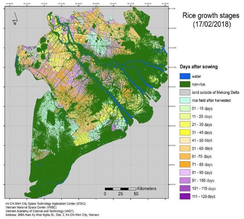
Table of Contents

Introduction							                1
2018 Asia-RiCE Highlights						    3
Indonesia							                   5
Vietnam							                     7
Cambodia							                    9
Japan								                     11
Conclusion						                  13
Introduction

Background                                                      Table 1 – Target Products for Asia-RiCE

The Asia-RiCE initiative has been organised to        Product            Description
develop the Asian Rice Crop Estimation and            P1: Rice Crop      Cultivated area (every year).
Monitoring (Asia-RiCE) component for the GEO          Area Estimates/
Global Agricultural Monitoring (GEOGLAM)              Maps               Inventory of agricultural facilities.
initiative. GEOGLAM aims to enhance                   P2: Crop           Timing of sowing, planting, growing
agricultural production estimates through the         Calendars/Crop     and harvesting/growing status.
use of Earth observations, and Asia-RiCE seeks        Growth Status
                                                                         Identification of growth stages.
to ensure that the observational requirements
for Asian rice crop monitoring are reflected in                          Planted area progress (every month)
                                                                         per season.
the GEOGLAM priorities.
                                                                         Crop growth anomaly.
The goal of Asia-RiCE is to foster the widespread
use of EO for ‘wall-to-wall’, whole country,          P3: Crop           Detection of flooding and other
                                                      Damage             disaster impacted area.
timely and accurate forecasts of rice production      Assessment
at national, regional, and global scales, as an                          Detection of drought or inundated
input to the GEOGLAM Crop Monitor and AMIS                               area.
Market Monitor.                                                          Detection of diseased plants, pests
                                                                         and diseased infestation.
Target crop and agricultural products are
summarised in Table 1. It is expected that            P4: Agro-          Early warning.
                                                      Meteorological
these products will be generated with national        Information        Anomaly detection (drought, extreme
resources as input to crop forecasting systems.       Products           temperatures).
                                                                         Crop growth anomaly.

Asia-RiCE & The Phased Approach                       P5: Yield
                                                      Estimation And
                                                                         Empirical-statistical model estimate.

                                                      Forecasting        Crop-growth simulation model
Asia-RiCE has leveraged existing agricultural                            estimates.
monitoring programs and initiatives at local
levels to develop, exercise, and refine processes,
and now moves on to full implementation and          Note: Phase 1A only covered rice area statistics,
product generation using SAR (i.e., radar) and       maps, and yield estimates. In Phase 1B (2014-
other Earth observation data for practical rice      2015), additional technical demonstration sites
crop monitoring.                                     in Chinese Taipei, Japan, and Malaysia were
This activity (being implemented in phases)          added.
will contribute to Goal 2 and other Goals of the     Phase 2 (2016 – 2018)
SDGs by improving rice crop productivity and         Following the successful demonstration of the
reducing environmental impacts.                      core functionality of Asia-RiCE, the initiative
Phase 1 (2013 – 2015)                                moved into Phase 2, which covered:
Phase 1A (2013-2014) consisted of four               • Scaling-up rice crop monitoring using SAR
demonstration sites in three countries:                   (adding rice growth outlooks for Laos,
Indonesia, Thailand, and Vietnam). Each of these          Cambodia, and Myanmar);
was focused on the development of provincial-
level rice crop area estimations.                    • Expanding from provincial-level to

01 | Introduction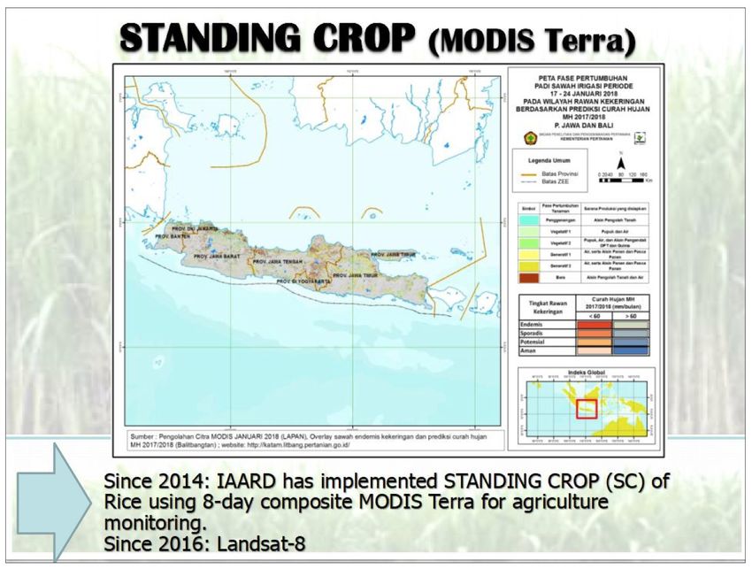
country/ region-level estimates (Vietnam &         research results, and progress at
     Indonesia);                                        international conferences such as the ESA
• Expanding rice growth outlooks using                  Living Planet Symposium, IGARSS, ACRS,
     satellite-derived agro-meteorological data;        etc.;
• Continuing rice growth outlooks for FAO/         • Continue to promote the generation of rice
     AMIS and related agencies via GEOGLAM              crop outlooks in Asia using the agro-met
     in collaboration with AFSIS (ASEAN+3 Food          information from Japan (JASMIN) and India
     Security Information System) project; and,         (MOSDAC).
• Wall-to-wall observation of selected             In addition to these practical aspects, the
     countries to implement national monitoring    following research topics are also priorities:
     systems.                                      • Research around creating ARD time series
Phase 3 (April 2019 – March 2021)                       from SAR and optical data for rice crop
                                                        monitoring using Open Data Cube;
Asia-RiCE is now in its third phase – expected
to run from April 2019 to March 2021. Phase 3      • Rice crop models for yield estimation;
aims to:                                           • Methane emission from paddy fields;
• Promote the use of EO data for wall-to-wall      • Standardization of field surveys for
     rice crop monitoring in cooperation with           validation of results at national and regional
     GEORICE and Asia-RiCE team members and             scales (in cooperation with GEORICE);
     international donors;                         • The practicality of potential integration of
• Promote the use of new generation tools               operational systems such as FASAL (India);
     for big EO data analysis, such as the Open    • Capacity building in Asia in cooperation
     Data Cube and cloud-based systems with             with available training centres such as
     available data sources and tools (such as          ARTSA, IIRS, CSSTEAP.
     INAHOR and GEORICE);
• Continue to promote the use of the Open
     Data Cube in Vietnam, Cambodia, and           Specific details of the work to be undertaken
     Chinese Taipei in cooperation with VNSC,      in Phase 3 can be found in the Asia-RiCE Phase
     GA, ESA/CNES, NSPO, and JAXA;                 3 Work Plan, which is available at:
• Promote outcomes, output applications,                          http://asia-rice.org/

       Asia-RiCE has linkages with
       major international frameworks
       such as the 2030 Agenda for
       Sustainable Development (SDGs
       1, 2, 3, 6, 10, 13 & 15), the Sendai
       Framework for Disaster Risk
       Reduction 2015-2030 (impact of
       drought and flood on agriculture,
       JASMIN agro-met system), and
       the Paris Climate Agreement
       (paddy field methane).

                                                                              02 | Introduction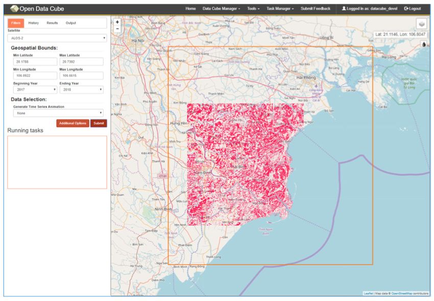
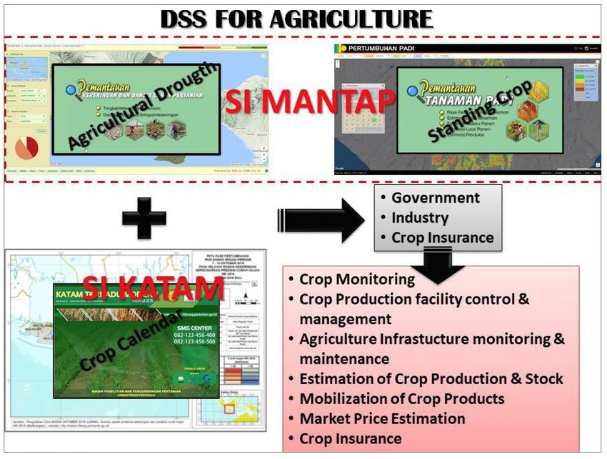
2018 Asia-RiCE Highlights
Asia-RiCE works to connect in-country Data Coordination & Supply
agricultural agencies, space agencies, and
global agricultural initiatives. Its activities are The Committee on Earth Observation Satellites
therefore broad. Some highlights are presented (CEOS) and its agencies are critical partners
here. for Asia-RiCE. Asia-RiCE works with these
space agencies to secure the data required by
in-country teams for development of target
Research and Development products as well as other research activities.
Activities
A key feature of the coverage being provided by
• Demonstration at Technical Demonstration CEOS agencies is the multiple band SAR (C/L/X),
Sites (TDS) in India, Japan, Malaysia, which facilitates important intercomparison
Philippines, Thailand, Taiwan (Chinese studies.
Taipei), Cambodia, and Myanmar from
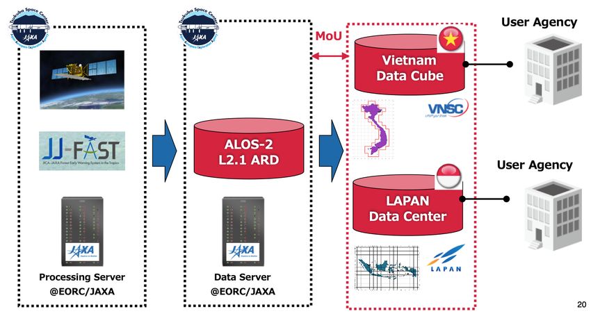
2016. In early 2019, JAXA provided further ALOS-2
PALSAR-2 ARD to Vietnam – covering Cambodia,
• Demonstration at regional/national scale: Laos, and Thailand – for the Mekong Data
wall-to-wall in Vietnam and top 10 rice Cube project (the VAST-VNSC 2019 CEOS Chair
production provinces in Indonesia. Initiative), which has a focus on rice products.
CNES/CESBIO integrate Sentinel-1 SAR ARD with
• APRSAF (Asia Pacific Regional Space Agency the Vietnam Data Cube for rice monitoring.
Forum) SAFE Initiative with ALOS-2 and
INAHOR for Cambodia, Indonesia, Myanmar
and Vietnam (Mekong Delta).
Open Data Cube & SAR ARD
Open Data Cube arranges data as a multi-
• ESA-GEORice using Sentinel-1 for Vietnam. dimensional (space, time, data type) stack of
spatially aligned pixels ready for analysis.
• ADB project using ALOS-2 (with INAHOR)
for Laos, Philippines, Thailand and Vietnam The powerful time series functionality of the
(Red River). Data Cube platform makes it very useful for
agricultural studies, including for rice.
• Ongoing research using SAR (L/X/C-band)
and optical (Sentinel-2/Landsat/Venus/ Critical for the Data Cube is Analysis-Ready Data
Formosat) data for rice yield and methane (ARD). CEOS, through its Land Surface Imaging
emission estimates at TDS and JECAM sites. Virtual Constellation (LSI-VC) has developed
the concept of CEOS Analysis-Ready Data for
Towards Operational Services Land (CARD4L) – satellite data that have been
• Setting up pre-operational services for rice processed to a minimum set of requirements
crop monitoring using ALOS-2 ScanSAR and and organized into a form that allows immediate
Sentinel-1 and other satellites in Indonesia analysis with a minimum of additional user
and Vietnam. effort and interoperability both through time
and with other datasets. JAXA is a co-lead of the
SAR CARD4L specifications.
http://ceos.org/ard/
03 | 2018 Asia-RiCE Highlights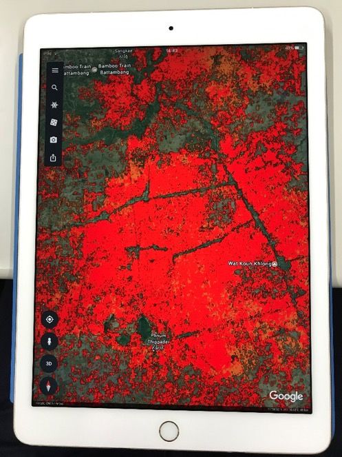
ALOS-2 PALSAR-2 ARD is supplied by JAXA to         defined locations. The outputs assist the ASEAN
Vietnam and Indonesia for their Data Cube          Food Security Information System (AFSIS) and
projects.                                          target country agricultural statistics experts in
                                                   preparing AMIS outlooks for Asia-RiCE.
INAHOR
                                                   With the 2017 launch of GCOM-C, agro-met
JAXA/RESTEC continued development of               related GCOM-C products with higher spatial
the INAHOR (INternational Asian Harvest            resolution (solar radiation, land surface
mOnitoring system for Rice; crop planted area      temperature, vegetation index) will be available
estimation software) and JASMIN (agro-met          on JASMIN after cross-calibration with the
information provision system for outlook) tools.   current MODIS products.
INAHOR estimates rice crop acreage and
production using space-based Synthetic
Aperture Radar (SAR) from the ALOS series,
RADARSAT-2 and Sentinel-1.
In 2018, JAXA/RESTEC successfully ported
the INAHOR algorithm to the Open Data
Cube platform and also developed a machine
learning version of the software (see page 11).

                                                   Reporting
                                                   Asia-RiCE continued its work with the ASEAN
                                                   Food Security Information System (AFSIS) to
                                                   provide crop condition overview information
                                                   and outlooks to the GEOGLAM Crop Monitor for
                                                   AMIS.

JASMIN
JASMIN provides satellite derived agro-
meteorological information including
precipitation, drought index, soil moisture,
solar radiation, land surface temperature, and
vegetation index. The tool is able to generate
two types of product for each parameter –
current condition, and anomaly, which is the
deviation from past year’s averages. JASMIN        The following sections, separated by country,
can generate either a map of the whole country     highlight some results from Asia-RiCE team
or time series graphs at a number of pre-          members.

                                                           04 | 2018 Asia-RiCE Highlights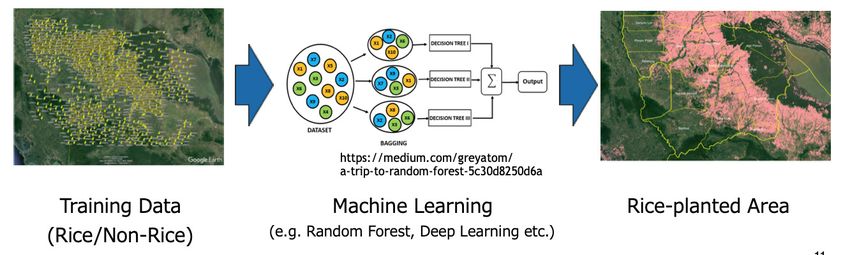
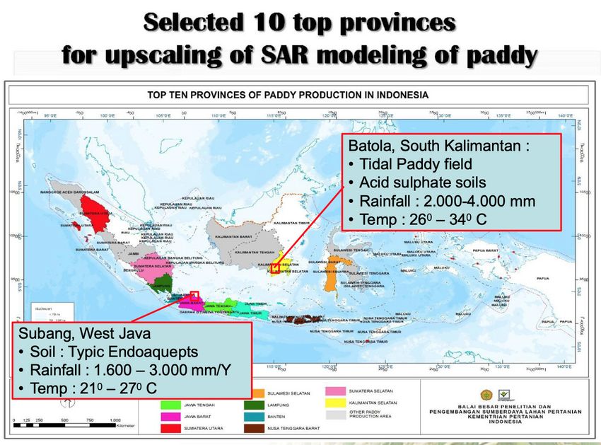
Indonesia

Objective: develop and upscale remote sensing      Conclusions
based models of paddy growth stage using
satellite data (optical and SAR).                  • The role of remote sensing technology is very
                                                   important as an information base to formulate
These models are used by the Indonesian            land management and agriculture policy to
Center for Agricultural Land Resources             support food security.
Research and Development (ICALRRD) and the
Indonesian Agency for Agricultural Research and    • Since 2014, a remote sensing-based
Development (IAARD).                               information system has been implemented in
                                                   Indonesia for crop monitoring to help policy
In 2016, the Indonesian rice crop monitoring       makers in agricultural management.
initiative was expanded to cover the top 10
‘high priority’ rice crop areas (in part because   • Improvement of the model is required to
the East-West extent of the country means          achieve the expected accuracy level as input
a larger number of satellite passes would be       reference for policy makers.
required to cover all areas).

05 | Indonesia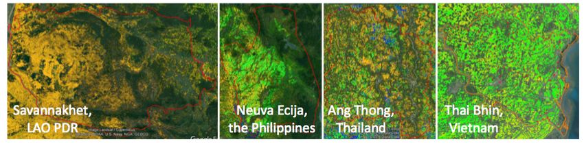
06 | Indonesia
Vietnam

Ho Chi Minh City Vietnam National Space           As the CEOS Chair for 2019, Vietnam seeks to
Center (VNSC) / Vietnam Academy of Science        integrate many of these ongoing CEOS activities
and Technology (VAST) performs surveying,         in support of regions most affected by climate
process and analyse data, and develop tools and   change, with a focus on the tropical monsoon
models, supported by Centre d’Etudes Spatiales    climate countries in South East Asia (Cambodia,
de la BIOsphère (CESBIO), France.                 Lao PDR, Thailand, and Vietnam).
VNRice (2017-2020)                                By putting the focus on this specific region, the
                                                  VAST-VNSC CEOS Chair hopes to enhance the
This is a state-level VNSC applied research       contribution and cooperation of CEOS Agencies
project on the use of multi-temporal, multi-      in the region, identify new Earth observation
resolution optical and radar remote sensing       users, and to respond effectively to their needs
data for rice planted area monitoring and rice    through integration across the full range of
yield/production estimation in the Mekong and     Earth observations by promoting the sharing
Red River Deltas.                                 of CEOS Agency data and algorithms, and by
                                                  improving access to and the use of such data
Vietnam Data Cube & 2019 CEOS                     via modern data architectures. Integrating
Chair Initiative                                  existing CEOS thematic acquisition strategies
                                                  and making data and algorithms available to the
Over the last few years, CEOS Agencies            international community will enable studies and
have prioritised efforts to make EO data          applications in relation to forests, agriculture,
more accessible, through initiatives such as      disasters, climate, carbon, and water.
Analysis Ready Data, Open Data Cube, and the
Copernicus Data Information Access Services       The 2019 Chair Initiative concept is one of a
(DIAS).                                           regional observatory, which is intended to
                                                  continue beyond 2019 and also be extended to
                                                  other hotspot regions.

                                    2019 CEOS Chair Initiative
                                        Key Components

07 | Vietnam
The project will leverage and expand the Open • CNES/CESBIO/GEORice have supplied and
Data Cube implemented at VAST-VNSC in Hanoi, ingested Sentinel-1 ARD into the VNDC.
Vietnam (officially launched 6 March 2018), to
users in the Mekong Delta region (Cambodia, • CESBIO and VNSC have implemented
Lao PDR, Thailand, and Vietnam). rice crop mapping algorithms and
demonstrated preliminary results using
The target products include the following for the VNDC.
rice:
Results from VNRice, GEORice, and INAHOR
• Rice Maps will all be compared and analysed.
• Rice Phenology / Growth Stage For more information on the 2019 CEOS Chair
Initiative, please see the website:
• Rice Crop Production / Yield Estimation
http://ceos.org/2019chairinitiative/
Asia-RiCE members are playing a key role in
the development:
• JAXA/RESTEC are porting the INAHOR
algorithm and providing ALOS analysis-
ready data (ARD).
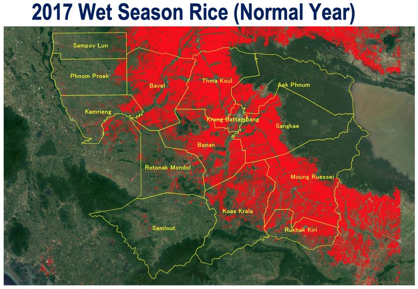
08 | VietnamCambodia
One of the newest members of the Asia-RiCE
team, Cambodia, through the Department
of Planning and Statistics, MAFF, is working
to promote rice planted area and production
estimation using space-based technologies.
Until now, paddy area and yield related
information has been collected through typical
data collection methods involving local level
surveys, however, DPS/MAFF don’t have any
means to check the quality of statistics reported
by these local offices.
The aim was to develop a new information
collecting method that would be cost-effective
and complementary to present rice crop Summary
area and production estimations, to support
statistical information generation and to verify • The judgement level of rice planted area by
statistics reported by local offices. INAHOR is acceptable.
Prototype Objectives • INAHOR can be used as a tool to make and
verify the report values.
1. Develop a standardized, accurate, cost
efficient and timely method to monitor rice crop • Especially, it can be expected that the
area. accuracy of the report value will be
improved by the utilization of INAHOR maps
2. Build capacity of SAR data processing by the district offices.
(INAHOR with ALOS-2 data).
• Further demonstrations for major rice
3. Create maps on land use/land cover as producing provinces are needed.
baseline information.
Next Steps
4. Develop a prototype validation framework
for statistics reported from local offices with • Expand the validation framework to the dry
satellite SAR-based information. season or other provinces, and establish
validation work.
INAHOR Validation Workshop and
Meeting (October 2018) • Secure budget for the operational
implementation of the validation work.
Participants from DPS, district offices (four
districts) and RESTEC/JAXA validated statistical • DPS and MAFF expect JAXA to continue
values using rice-planted areas and maps with the provision of ALOS-2/INAHOR or
estimated using INAHOR (for Battambang seasonal rice-planted area maps derived
province) and identified the causes of from ALOS-2, and to refine INAHOR to
differences between the official statistics and identify rice planted area which is cultivated
the INAHOR results. two times per rainy season.
09 | Cambodia^ Rice planted areas from statistics were
highly consistent with the INAHOR results.
> Local officers used the map function on
smartphones to validate reported values
during field visits.
10 | CambodiaJapan
INAHOR A Python version of the INAHOR tool has also
been developed for use specifically with the
JAXA/RESTEC provide the INAHOR Open Data Cube.
(INternational Asian Harvest mOnitoring system
for Rice, crop planted area estimation software)
and JASMIN (agro-met information provision
system for outlook) tools to assist the ASEAN
Food Security Information System (AFSIS) and
target country agricultural statistics experts in
preparing AMIS outlooks for Asia-RiCE.
Through an Asian Development Bank Technical
Assistance project and SAFE projects under
APRSAF, INAHOR (using ALOS-2) has been
demonstrated to achieve mapping accuracies of
80-90% for target provinces (in Laos, Thailand,
Vietnam (North), Philippines, Myanmar,
Cambodia, and Indonesia).
ALOS-2 Analysis Ready Data (ARD)
INAHOR-NEO, a machine learning version of for Agriculture
the software was developed in 2018. Originally,
users would input two threshold values based CEOS, through its Land Surface Imaging
on field survey results, however with INAHOR- Virtual Constellation (LSI-VC) has developed
NEO much larger training datasets are used to the concept of CEOS Analysis-Ready Data for
automatically produce classification models Land (CARD4L) – satellite data that have been
using a machine learning algorithm. Higher processed to a minimum set of requirements
accuracies can be achieved with this new and organized into a form that allows immediate
version. analysis with a minimum of additional user
INAHOR has been updated in 2018 to incorporate machine learning capabilities
INAHOR Outputs
11 | Japaneffort and interoperability both through time 2018 Summary
and with other datasets.
http://ceos.org/ard/ • The INAHOR (rice-planted area mapping)
software has been demonstrated in
JAXA is a co-lead of the SAR CARD4L collaboration with Southeast Asian
specification and also supplies ALOS-2 ARD for countries.
agricultural monitoring purposes. This ARD is
processed using SIGMA-SAR and was originally • A new classifier (random forest) with
processed for the JICA-JAXA deforestation training data showed higher accuracy
monitoring project, JJ-FAST (JICA-JAXA Forest compared to conventional INAHOR.
Early Warning System in the Tropics). It is ortho-
rectified/slope-corrected gamma nought data. • The algorithm in INAHOR is currently being
modified to improve the accuracy (e.g.,
fusing multi-freq/pol and optical data,
applying machine learning approaches).
• ALOS-2 ARD for agricultural monitoring is
being processed, stored on JAXA servers,
and transferred to Vietnam and Indonesia.
ALOS-2 PALSAR-2 ARD is currently being
supplied by JAXA to Vietnam and Indonesia for • With the launch of GCOM-C, agro-met
their Data Cube projects, including the 2019 related GCOM-C products with higher
CEOS Chair Initiative. spatial resolution (solar radiation, land
surface temperature, vegetation index)
will be available on JASMIN after cross-
calibration with current MODIS products.
Data Transfer Network for ALOS-2 ARD
12 | JapanConclusion A Critical and Unique Space Agency Service Asia-RiCE has demonstrated the great utility of the initiative, with substantial amounts of CEOS data flowing from space agencies to in-country agricultural agencies and researchers – an achievement that would not have been possible without the collective efforts of the group and its connections to GEOGLAM and CEOS. As a result of Asia-RiCE, improved rice production estimates are being generated at national, regional, and global scales – valuable inputs to the GEOGLAM Crop Monitor and AMIS Market Monitor that would not otherwise be present. Asia-RiCE thanks all CEOS agencies for their unique and critical contributions. 13 | Conclusion
14 | Conclusion
You can also read