The Summer of 2017 in Review - National Weather Service
←
→
Page content transcription
If your browser does not render page correctly, please read the page content below
The Summer of 2017 in Review
John La Corte – Lead Meteorologist

After the summer of 2016 reminded everyone
what a truly long hot summer could be like, this
year was actually pretty pleasant for a change.
Figure 1 shows that as far as temperatures go,
most of the region did not vary much either side
of normal. After June and July ended up about
1-2 degrees above average in most areas,
August reversed the trend was rather cool. In
the end, the summer concluded on the
                                                   Figure 1. Average Temperature Departures Summer 2017
comfortable side when we went through a
pretty good stretch where day time highs were
warm and the low humidity led to very
comfortable overnight lows. Something we
seldom see here in Central Pennsylvania.

Rainfall on the other hand was plentiful. A wet
July was sandwiched between a June and
August where rainfall was close to or slightly
below normal in most locations. Figure 2 shows
that except for a small portion of the Northern
Mountains, most areas ended up 3 inches or
more abvove normal for the season.

                                                   Figure 2. Precipitation Departure Summer 2017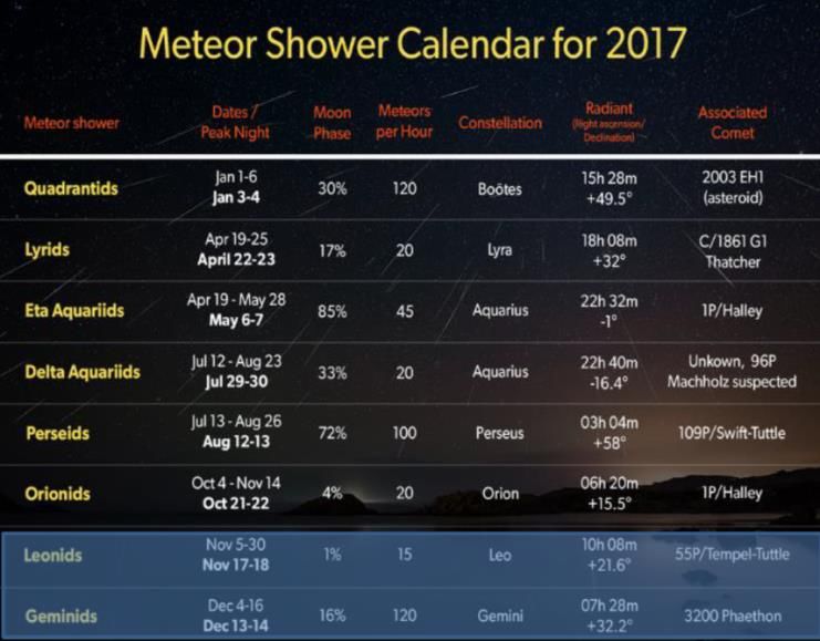
Another measure of how warm a summer is            The CPC has issued a La Nina watch meaning
involves the number of days we hit 90 degrees      they expect the tropical waters to be cooler
or warmer. Table 1 shows the comparison            than normal. So what does that mean for our
between this year and last and we can quickly      forecast?
see this year experienced fewer than half the
hot days compared to the long hot summer of        During a “normal” La Nina winter, local
2016.                                              temperatures tend to average close to average.
                                                   (Fig 3). After factoring in all the forecast inputs,
                                                   the official CPC forecast actually leans toward a
                                                   slightly elevate probability of a warmer than
                                                   normal temperature (Fig 4).

Table 1. Number of 90 Degree Days

All in all, the summer was uneventful with heat
waves not creating much in the way of
headlines.

                  Winter Forecast?
                                                   Figure 4. CPC Winter Temperature Outlook
So what may the upcoming winter have in store
                                                   The seasonal precipitation during a typical La
for the region? For that we turn to our Climate
                                                   Nina has the local area near to slightly above
Prediction Center, the CPC and see what they
                                                   normal with storm tracks that favor moving up
have to say.
                                                   to our west through the Great Lakes (Fig 5).
One of the ingredients (but by no means the
only one) that get fed into the climate modeling
system is the predicted state of the ENSO, or El
Nino Southern oscillation. Simply put, will the
water temperatures over the tropical Pacific be
warmer, colder or near normal?

                                                   Figure 5. La Nina Precipitation Anomaly Composite

                                                   The CPC forecast (Fig 6) looks similar with the
                                                   Ohio Valley favoring wetter than normal
                                                   conditions and the local area in the transition

Figure 3. La Nina Temperature Anomaly Composite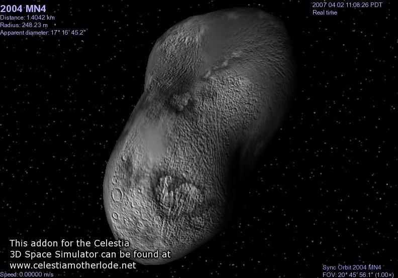
they are forecasting a warmer than normal
                                                   winter over central Pennsylvania. They also
                                                   expect above normal precipitation but below
                                                   normal snowfall. Since their forecast recipe
                                                   involves highly secret ingredients and
                                                   processes, we will never know what went into
                                                   that forecast, but they do agree with the CPC on
                                                   the temperature outlook. As always, we will
                                                   take a look back next spring to see how it all
                                                   unfolded. Have a happy and safe winter!
Figure 6. CPC Winter Precipitation Outlook
                                                   Oh What a Hurricane Season it Was!
zone between increased chances for wet
                                                   John La Corte – Lead Meteorologist
conditions to our west and dry to our south and
east.
                                                   Technically the hurricane season runs until the
Lastly, what everyone wants to know is how         end of November, but even if it was over today
much snow we will get? The CPC doesn’t             it was one for the ages. Hurricanes Harvey and
explicitly forecast snowfall, just the overall     Irma struck the US mainland within 2 weeks of
precipitation (above). But during a typical La     each other from late August into early
Nina winter, with the storm track tending to be    September. Harvey blasted the Texas coast and
west of Pennsylvania, we typically experience      dumped record setting rains on the Houston
below normal snowfall (Fig 7). But keep in mind;   area, and Irma devastated the Florida Keys and
it only takes one big storm to turn those          southwestern Florida. Then of course, what
expectations on their head.                        happened and is still happening in Puerto Rico
                                                   remains in the news after Hurricane Maria
                                                   bulldozed a direct hit on the island.

 Figure 7. La Nina Snowfall Composite

We also take a look at the venerable outlooks
provided by the winter forecasting gurus at The    Figure 1. Hurricane Harvey
Old Farmer’s Almanac. They have been
providing these outlooks since 1792 and boast      Figure 1 shows the track of Hurricane Harvey. It
of a 90% forecast accuracy record. This year       rolled through the southern portion of the
                                                   Windward Islands as a relatively weak Tropical
Storm late in the day on August 18, and in fact it   north and roaring though the Keys into
weakened sufficiently by the 19th that the           southwestern Florida where category 4 winds
National Hurricane Center (NHC) stopped              and storm surges brought widespread heavy
issuing bulletins on the storm. The remnants of      damage.
Harvey could be tracked west across the
Caribbean over the Yucatan Peninsula into the        Irma was a huge storm areal-coverage wise,
Gulf of Mexico where conditions became               bringing hurricane force wind gusts to much of
                                                     the east coast of Florida, a hundred or more
favorable to breathe new life into the storm.
                                                     miles away from the eye of the storm! It
By the 23rd Harvey was once again a Tropical         eventually moved up the entire length of the
Storm and it intensified steadily to a Category 4    peninsula weakening along the way, before
storm before crashing ashore between Corpus          dying over the southern Tennessee Valley.
Christi and Aransas Texas. While the smaller
coastal towns were hit very hard, the real           The last of the big storms (so far?) was
damage was done in and around Houston                Hurricane Maria (Fig 3). The storm came
where the rain was measure in feet, not inches.      together just east of the Windward Islands in
The flooding was record setting and will be the      mid-September before it underwent a period of
standard against which future storms will be         explosive intensification, hitting the island of
                                                     Domenica as a Category 5 storm late on
measured for years to come.
                                                     September 18th. More than 95% of the island’s
Irma (Fig 2) began way out in the Atlantic Ocean     buildings were damaged or destroyed. That
and for almost the entirety of the storm’s life,     would have been bad enough except for what
conditions for intensification proved to be          Maria still had in store for the region.
nearly ideal. As a result, the storm intensified
steadily and rapidly and spent a record setting
amount of time as a Category 5 hurricane
plowing through the northern Leeward Islands,
devastating St. Martin and Anguilla.

                                                     Figure 3. Hurricane Maria

Figure 2. Hurricane Irma
                                                     The storm soon rampaged through the
                                                     southern Virgin Islands and took direct aim at
The storm passed just north of The Dominican
                                                     the southeast coast of Puerto Rico during the
Republic and moved through the southern
                                                     overnight hours of September 20th. It was still
Bahamas on September 9th. Irma tracked just
                                                     an extremely dangerous category 4 storm and
along the northern coast of Cuba before turning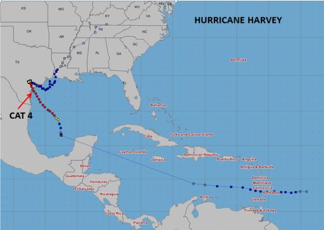
the damage done to the islands was severe and        available. CWD has been noted in south central
is still being evaluated.                            Pennsylvania and in now into Clearfield County.

Maria was soon to move just east of the Turks        Persons engaged in animal production, deer
and Caicos Islands in the Bahamas before             hunting and other outside activities should use
meandering north off the Eastern Seaboard            care when processing deer. The most updated
where the main effects were rough surf along         information from the Pennsylvania Game
the beaches and some gusty Tropical Storm            Commission is that the spongiform can stay in
force gusts over the Outer Banks of North            the soil for upwards of 16 years and plants can
Carolina. Maria would eventually take a hard         absorb it. It is not a virus or bacteria, but an
right turn weakening over the colder Atlantic        abnormal protein. There is no evidence of CWD
waters well southeast of New England.                making a jump to the human population, but
                                                     care needs to be taken when handling deer and
It will take months for the final tallies in lives   elk. Hunters should avoid eating tissue that can
lost and property damaged or destroyed to be         harbor the CWD agent such as the brain, spinal
done, but there is no doubt the Hurricane            cord, eyes, spleen, tonsils, and lymph nodes.
Season of 2017 certainly cemented its place in       This is especially the case for animals from
the record books as one for the ages!                areas where CWD has been identified.
Update on Warm and Cold Season                       We should not feed wild animals.
Hazards
                                                     Some things to watch for with deer and elk
David Martin – General Meteorologist                 beside weight loss is decreased interactions
                                                     with other animals, listlessness, lowering of the
In recent years, there has been a tendency for       head, tremors, repetitive walking in set
more extreme weather events. There is                patterns, excessive salivation, and grinding of
increasing evidence that this has an influence       the teeth. Other symptoms also include
                                                     increased drinking and urination with affected
on insects, animals, and disease. In the last
several newsletters I have written articles on       animals. This may lead in part to the spread of
various subjects such as the decline of Monarch      the disease.
Butterflies and Lyme disease and why.                Chronic wasting disease was first noted in
Another concern showing up in Pennsylvania in        Adams County in 2012 and in Bedford, Blair,
recent years is chronic wasting disease (CWD).       Cambria, and Fulton Counties between 2012-
CWD (transmissible spongiform                        2017, and in Clearfield County this year.
encephalopathy) occurs in mule deer, white-          UPDATE ON TICKS
tailed deer, elk, moose, and reindeer. The first
case of this disease was noted in Colorado in        An update on Lyme disease and ticks is listed
1967.                                                below.

Chronic wasting disease results in weight loss
and death. In recent years CWD has spread to
many states and parts of Canada. No cure is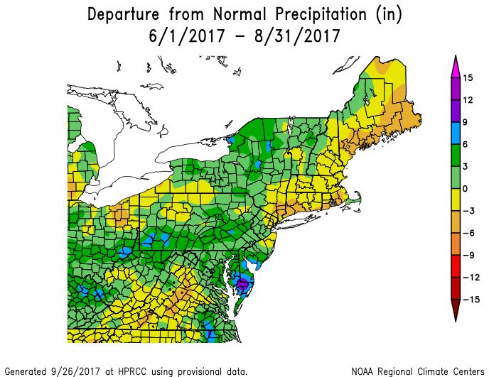
Aside from Lyme disease, ticks can carry the         visibility, gusty winds and falling temperatures
Powassan virus. The Powassan virus is not as         causes extremely dangerous driving conditions
common as Lynn’s disease, but has no cure.           to develop rapidly for motorists. Minor
Unlike Lyme, the tick only has to be on a person     accidents quickly snowball into fiery multiple
for a few minutes for transmission. Within two       vehicle pileups as motorists are unable to see
to three hours of being bitten by a tick infected    and safely stop their vehicles from becoming
with the Powassan virus, one may notice              part of the mass of twisted metal. Annual
headaches, nausea, vomiting, muscle weakness,        highway fatalities from these events can even
memory loss, and problems with speech. Unlike        exceed fatalities from tornadoes.
Lyme, no rash forms.
                                                     Up until now, the NWS has issued locally-
MONARCH BUTTERFLY UPDATE                             specific Special Weather Statements (SPS) for
                                                     snow squalls, as no formal warning had been
The winter Monarch Butterfly population in           implemented for these events. However, these
Mexico last winter was down by about 27              statements had limited reach, and did not
percent from 2015-2016 levels. This was largely      convey the threat to life and property that a
due to a series of severe storms that hit Mexico     formal warning does. We are pleased to
at the worst possible time for the butterflies.      announce that starting in January 2018, the
We can help out by not destroying milkweed.          NWS will implement operational Snow Squall
Monarch Butterflies need this plant to survive       Warnings (SQW). The warning will be short-
and breed.                                           fused and polygon-based, similar to severe local
                                                     storm warnings (Severe Thunderstorm or Flash
NWS State College to Test                            Flood), and will greatly facilitate distribution
Operational Snow Squall Warnings                     and promote/provide more efficient decision
This Winter                                          support services.

Greg Devoir – Lead Meteorologist                     Adding this new product does not diminish the
                                                     agency’s commitment to overall hazard
                                                     simplification and associated reduction in the
Intense snow squalls, frequently accompanying        number (consolidation) of Watch, Warning and
strong arctic cold fronts, are a critical            Advisory (WWA) products. As NWS continues to
wintertime weather hazard in Central                 move forward with simplifying our suite of
Pennsylvania. Severe local impacts to the            products, the Snow Squall Warning will be
traveling public and costly disruptions to           considered for consolidation into the Winter
commercial interests/interstate commerce can         Weather product suite. We are excited to add
result from the instantaneous loss of visibility     this new capability to save lives now and
and traction and resultant multi-vehicle pileups     address the needs expressed by our forecasters
associated with these snow squalls.                  and partners.
Pennsylvania has a long history of tragic and
deadly pileup accidents associated with snow
squalls. Although snow accumulations are
typically an inch or less, the combination of zero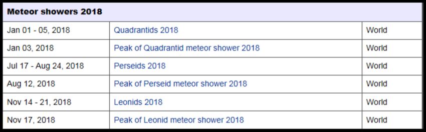
Near Earth Objects and Meteor                         When we change the Nominal Distance of the
Showers for 2017-18 and Beyond                        object’s passage from 0.05 Solar Distance (au)
                                                      to Less than 1 Lunar Distance (LD), in order to
By Barry C. Lambert – Senior Meteorologist            emphasize the rare, but nonetheless potential
1) Near Earth Objects (NEO):                          Earth impacts, we see that the first such
                                                      occurrence in Earth’s future comes on
Near Earth Objects (NEOs) have been around as         September 1, 2020 by NEO (2011 ES4). This
long as the Earth has (no pun intended).              unwelcome visitor about 20-40 meters in size
                                                      will pass within about 1/5 the earth-moon
If you think Climate Change is a significant          distance (the moon is about 238,900 miles
regional and global issue now, how about a
                                                      away).
record air temperature that likely occurred on
Earth about 38 million years ago? -- 2370             The greatest threat (but still quite a remote
degrees C (4298 degrees F)! This extremely hot        chance) of a collision by a large NEO within at
regional temperature was hypothesized to be           least the next 100 years appears to be by the
the result of a meteorite that struck the earth       well-documented and more easily tracked
and formed the 28km wide Mistastin Lake               99942 Apophis (2004 MN4). This approximately
located in Labrador, Canada.                          one-third of mile wide, oblong asteroid will
                                                      make an extremely close approach to Earth of
https://cneos.jpl.nasa.gov/ca/                        about one-tenth the distance to the moon (as it
                                                      trails our orbit around the sun and closes in) on
                                                      Friday the 13th of April, 2029. Another
This link is a table of all known and tracked         apparently less threatening pass by the Earth
close approaches to Earth by NEOs. Pertinent          occurs on Sunday the 13th of April, 2036!
information within this table are 1) the close
approach date, 2) the distance from Earth
measured in Nominal and Minimum “Lunar”
and “Solar” distances (LD and au), and 3) the
size or estimated diameter of the NEO. For the
next several months, the closest approach by
any tracked object will be on December 20,
2017 by the space rock called – (2006 XY). This
42-92 meter wide NEO will pass by Earth at
anywhere from about twice the distance of the
moon to 6 times the distance. Looking out a
little further in time, another, relatively smaller
(6-14 meter wide) and very recently discovered
NEO (2016 JQ5) will pass earth within 1-6 Lunar       Figure 1. Simulated image of Apophis on April 2, 2007
Distances on May 8, 2018. A similarly small NEO
                                                      Here are a few brief articles about the 2036
(called 2015 HG182 and measuring 4-10 meters
                                                      close approach of Apophis:
wide) is expected to race by our planet at
roughly the same distance on October 11, 2018.
https://www.space.com/19221-asteroid-                 There are a few additional, much closer, but
apophis-earth-safe-2036.html                          much later passages by smaller NEOs, namely
                                                      2012 HG2 (that measures 11-24 meters wide
http://www.skyandtelescope.com/astronomy-             and passes within a minimal Lunar Distance of
news/asteroid-apophis-takes-a-pass-in-2036/           just 0.0002 or just 48 miles above the earth’s
A collision by a NEO this size would be               surface) on February 13, 2047, and the 6-14
catastrophic on a large regional, if not              meter wide, 2010 RF12 that could come within
continental scale. Here are a few fantastic video     1600 miles of earth. Both of these NEO
presentations that show the difficulty detecting
elusive asteroids and an explanation of Apophis.

https://www.youtube.com/watch?v=LmVpx8P4
GHM

https://www.youtube.com/watch?v=1NyG4q4H
K08

By comparison, the Tunguska event
(Krasnoyarsk Krai, Russia) on the morning of
June 30, 1908 flattened 2000 square kilometers
(770 square miles) of forest, but caused just 2
“unofficial” deaths in the very sparsely
populated Eastern Siberian Taiga. The explosion       Figure 3. Extent of the Tree Damage from the Tunguska
                                                      Event
was an “Air Burst” of a meteoroid (either a
dense Asteroid or Comet measuring 60 to 190
                                                      passages are well within the orbit of our
meters in diameter respectively) at an altitude
                                                      Geostationary Satellites (22,300 miles)! Even
of 5 to 10 Kilometers above ground (3-6 miles),
                                                      the much larger Apophis asteroid moves by
rather than a direct earth impact. This is the
                                                      Earth at a minimal distance equal to just twice
largest Earth impact event to occur in recorded
                                                      the height of our Geostationary Satellites. We
history. Modern supercomputer estimates are
                                                      have 12 long years to track this space rock,
that the energy released by this air burst was 3
                                                      calculate if it’s more of a threat than just a close
to 5 megatons of TNT, roughly equal to the
                                                      passage, and if so, devise a plan to divert its
United States’ Castle Bravo ground-based
                                                      course just slightly (while it’s still fairly far out in
nuclear thermonuclear detonation on March 1,
                                                      space) in order to have it miss Earth.
1954.
                                                      2). Meteor Showers:

                                                       What is a meteor shower? Meteor showers
                                                      take place when typically very small space
                                                      rocks, also known as meteoroids, enter the
                                                      Earth’s atmosphere. When there are numerous
                                                      rocks at the same time, this is known as a
                                                      meteor shower. Meteoroids are often so small

Figure 2. Trees flattened by the Tunguska Air Burst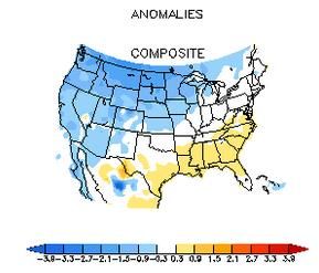
(the size of a grain of sand) that they burn up
quickly in the earth’s atmosphere, so there is
little chance of a collision. Meteor showers are
named after the constellation where the rocks
appear to be coming from. The streaks of light
you can see are actually caused by tiny bits of
dust and rock called meteoroids entering the
Earth’s atmosphere and burning up. As a rock
falls towards earth, resistance of the air on the
meteor makes it hot and air around it glows –
which has led to them being known as shooting
stars. They often appear with a streak of light
                                                      Figure 5 Major Meteor Showers for 2018
behind them, caused by the remains of the
super-heated rock burning up as the meteoroid         Here is a fantastic site (the International Meteor
falls to Earth.                                       Organization) that describes in detail each
                                                      major meteor shower in 2018 (along with some
Light pollution, specifically that from a bright
                                                      of the less famous events), and provides a sky
moon, greatly affects your ability to see and
                                                      chart that shows the surrounding constellations
enjoy the spectacle of one of the primary
                                                      and radiant for each day of the meteor shower.
meteor showers each year. Prior to setting
aside precious time to view a meteor shower,          https://www.imo.net/files/meteor-
it’s good to know what kind of moonlight you’ll       shower/cal2018.pdf
be competing with that night.
                                                      Similar with all meteor showers, dry, clear skies
Here are the lunar calendars for 2017 -               are key, so people are advised to check with the
https://www.timeanddate.com/moon/phases/              nearest National Weather Service Office for the
and 2018 - https://www.calendar-                      latest weather reports with the goal of finding
365.com/moon/moon-phases.html before the              out the best viewing times.
event, if the moon is too bright during its full or
gibbous phase, it may obscure the view.               When trying to observe the showers, always
                                                      look towards the radiant (where the meteor
                                                      originates), and a constellation chart can help
                                                                              determine this. The
                                                                              shower is usually named
                                                                              after the radiant
                                                                              constellation. Most
                                                                              meteors can be seen
                                                                              with the naked eye, so
                                                                              don’t worry if you don’t
                                                                              have expensive
Figure 4. Major Meteor Showers for 2017
                                                                              equipment, but
                                                                              binoculars and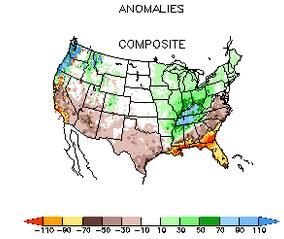
telescopes can help you get a closer look if you    U.S. mail:
wish.
                                                    William Gartner/Skywarn Spotter Update
Bolide meteors or “Fireballs” typically range in    NWS/WFO State College
size from a rock you can hold to a large boulder
                                                    328 Innovation Blvd, Rm #330
weighing several tons. Here is a great video
compilation of a fireball seen over various parts   State College, PA 16803
of the northern hemisphere in March 2017 –

https://www.youtube.com/watch?v=APep3sgw            If you are not sure that we have the most up to
Ez4                                                 date information on file, go ahead and send us
                                                    an email or note with your current information
If you happen to be lucky enough to catch a few     anyway and we will verify it. Please note that
to several second glimpse of a bolide meteor,       your personal information (address, phone #,
the American Meteor Society (founded in 1911)       email mail address, etc) is NOT shared with or
website https://www.amsmeteors.org/ serves          given to anyone else outside of the NWS (unless
as the primary site to report a bolide meteor -     your permission is gained first) and is used only
under their Fireball Tab. Please take a few         to contact you in the event of severe weather,
minutes to record your sighting of a Bolide         send you SkywarnNews email notification, or
Meteor.                                             communicate important program changes.
Happy viewing of the numerous meteor
                                                    Please report the following:*
showers during the upcoming year, and any
other celestial objects that may come your way!     Snow:
                                                    - When snow accumulation reaches 3 inches
Spotter Information
                                                    - When snow accumulation reaches 6 inches
Please help us to keep your contact information     - Storm total after the snow ends (also water
up to date. While we hope to get a report from      equivalent if possible)
you when severe weather occurs, from time to        - If snow is falling at the rate of 1 inch or more
time we call or email spotters to investigate       per hour
significant storms. Thus, it is important to keep
your contact information current. If any of your    Ice:
contact information (name, phone number/s,          - Any occurrence of or accumulation of freezing
addresses, etc) has changed recently, please let    rain or freezing drizzle
us know. Send an email or ‘snail mail’ note to us   - Accumulation of ice of ¼ inch or more on trees
at one of the addresses below.                      or wires

email: william.gartner@noaa.gov                     Other:
                                                    - When forecast winter precipitation differs
                                                    significantly from observed (i.e. snowing with
                                                    no snow in forecast, sleet...when only snow is
                                                    forecast...)
                                                    - Any other significant weather
occurrence/oddity (i.e. flooding due to snow
melt/ice jam, damage from strong winds not
associated with a thunderstorm)
And, remember thunderstorms that produce
wind damage and flooding rains are still
possible even in winter.
*This list of reporting criteria is available on our
web page:
http://www.weather.gov/ctp/reportSevere
We have been publishing this newsletter twice
a year since the mid-1990s. We’d like to get a
feel for how many people read it or even look
forward to it each Spring and Fall.
We will not use you email address for any kind
If you enjoy our bi-annual publication, or even if of solicitation.
you have suggestions on how to make it better,
please take a moment to drop us a line at
ctp.stormreports@noaa.govYou can also read