The weather and climate of the tropics - Part 1 - Setting the scene
←
→
Page content transcription
If your browser does not render page correctly, please read the page content below
The weather and
                                                                   climate of the tropics
                                                          Part 1 – Setting the scene
J. F. P. Galvin                                      out within the tropical zone. What we know           systems throughout the globe, providing

                                                                                                                                                             Weather – September 2007, Vol. 62, No. 9
                                                     of the weather (and, to some extent, the             much of their energy.
Met Office, Exeter                                   climate) of the tropics remains limited and
                                                     has typically focused on severe weather              How can we define the
In this series, I will describe various aspects      events, such as tropical revolving storms
of tropical weather and climate as it is             (e.g. Emanuel, 2005), or data from a limited
                                                                                                          tropics?
understood today. The series will cover              range of observing stations. However, many           The most commonly used definition of the
these topics: the sub-tropical jet streams;          factors of the day-to-day weather are impor-         tropics is the zone within which the Sun is
synoptic-scale weather systems; forecasting          tant in the tropics, not least for aviation and      directly overhead at some time during the
significant cloud and associated weather;            public safety.                                       year, i.e. the zone between the tropics of
dry environments; the development and                   For instance, the primary purposes of             Cancer and Capricorn (23.45°N and 23.45° S,
maintenance of monsoon systems; tropical             forecasting for aircraft operations in the           respectively). However, a more meteoro-
revolving storms; and mesoscale convective           tropics are safety and maximization of effi-         logical definition, rather than the elevation
complexes. Each part will include a descrip-         ciency for the benefit of passengers and air-        of the Sun at midday, is probably more
tion of the effects of tropical weather.             craft operators. The most accurate and               useful to both the weather forecaster and
   This series is not intended to be a detailed      appropriate forecasts will achieve this goal,        the climatologist.
mathematical description of tropical                 using a mixture of numerical weather pre-               A simple method is to divide the globe
weather. A number of very good texts are             diction products, observed data and good             into tropical and extra-tropical zones. This is
available for those who wish to go into              forecasting knowledge. It is the effects of          a method often employed for the verifica-
greater depth; in particular, I recommend            the weather, in other words its outcomes,            tion of numerical forecasts (WMO, 1982;
Hastenrath (1991) and Riehl (1979).                  which must be considered.                            Fuller, 2004). One such method divides the
   Much of what we know about the                       The research carried out as part of the           globe into two equal halves – tropics and
weather has been focused on mid-latitude             World Climate Research Programme since               extra-tropics – with somewhat arbitrary
weather systems: first, because most early           the early 1970s is very important in allowing        dividing lines at 30° N and 30° S. Con-
researchers came from Western Europe and             us to understand many of the processes and           veniently, this latitude range includes
eastern North America; and second,                   associated weather of the tropical zone              almost all of the climatic zones that can be
because of the risks and consequences of             (Gates and Newson, 2006). Knowledge con-             regarded as tropical: humid equatorial,
weather systems prevalent in these zones.            tinues to grow through more recent                   savannah, semi-desert scrub and hot desert
However, although there are simple non-              research programmes, such as TOGA, which             (Figure 1).
scientific descriptions of weather events            investigates the important links between                However, the zones of predominantly
from the tropics going back hundreds of              the tropical ocean and the global atmos-             westerly winds make incursions equator-
years, it is only since the late 1960s that          phere (Fleming, 1986). It is clear that the          ward of these lines of latitude, particularly in
much scientific research has been carried            tropics have an important effect on weather          winter. In order to keep within a zone of

Figure 1. Climatic zones of the tropics: Af, Am – tropical rainforest; Aw – savannah; BSh – tropical steppe; BWh – tropical and sub-tropical desert;
Cs – dry-summer sub-tropical; H – highlands; Cf – warm temperate with no dry season; Cs – warm temperate with dry summer; Cw – warm temperate
with dry winter; stippled– modification due to altitude. The effect of high ground has a profound influence on climate in the tropics, particularly above
about 2km. (Using the system devised by Wladimir Koppen.)                                                                                                                          245
predominantly easterly winds at most levels, Although use of the STJ as the northern Despite its relatively uniform depth for
a narrower zone must be used. Where an and southern limits of the tropics means much of the year, some variation occurs
automated system, such as the verification that the tropical zone extends north of 40°N with the changing of the seasons and these
The weather and climate of the tropics
of numerical forecasts, is not required, there over Asia during the northern summer, it is variations are notably marked in the North-
are better climatological or synoptic-mete- appropriate, since the air to the south of it ern Hemisphere summer. Between late May
orological ways to define the tropics. retains tropical characteristics. To provide and late September, the tropopause is high-
A more useful definition for the climatolo- consistency throughout this series of er over north Africa and south Asia than it is
gist is based on the small annual variation of papers, some areas poleward of the mean close to the Equator. The intense warming
climate typical in the tropics. Riehl (1979, latitude of the STJ will be discussed, since of these land masses causes the tropo-
Ch. 2) proposed the definition as the area these areas spend part of the year within the sphere to expand and the tropopause occa-
within which the diurnal temperature range meteorological tropics. This also allows sionally reaches a height of 18 km over
exceeds the range of annual mean tem- inclusion of areas frequently affected by Tibet. Smaller expansions occur over
perature. This has great value, since data can upper-tropospheric troughs in the STJ. Australia, Africa and South America during
easily be sorted using this definition. How- the southern summer. The expansion is a
ever, the weather forecaster usually needs key element in the development of the sum-
The tropical troposphere
Weather – September 2007, Vol. 62, No. 9
something more closely related to the daily mer monsoon circulations (to be described
weather, without reference to seasonal vari- The height of the tropopause varies little in in Part 6).
ations. the tropics, but is related to the mean tem- Associated with the great depth of the
Using current weather, it is possible to perature of the troposphere. Thus the tropi- tropical troposphere is a high total (1000–
define the tropical zone on a daily basis. The cal zone effectively contains a single air 500 hPa) thickness. This generally has a
temperature difference between the tropics mass. However, variations in mean tempera- minimum around 580 decametres along the
and middle latitudes causes a jet stream to ture and dynamics cause some variation and northern and southern boundaries of the
develop at the poleward limit of the tropics. the highest tropopause heights are tropical zone and may reach 590 deca-
This sub-tropical jet stream (STJ) has a core generally found close to the Equator. The metres or more in places.
close to 30°N and 30°S and has little high- height of the troposphere rarely extends
amplitude wave development along it above 17 km* and is most often between
(Figure 2). The area between these jet 15 km and 16 km. Height gradients are usu- Winds in the tropical zone
streams has a tropospheric depth character- ally small, but increase somewhat near the Within the tropics, winds are often relatively
istic of the tropical zone. This depth allows us sub-tropical jet streams. Indeed, the associa- light, in particular at upper levels. Over the
to define the periphery of the tropics, even tion of the STJ with a tropospheric depth of Atlantic and much of the Pacific, these are
when the STJ weakens or is absent, as often about 15 km provides a definition of tropical westerlies throughout the year. Over the
occurs in summer, as is usually the case in the air. western Pacific, Indian Ocean and Africa,
Northern Hemisphere in summer. Further- there are high-level easterlies close to the
more, the STJs coincide with the transition * Altitudes given in this series of articles Equator (Figures 2 and 3). At low levels,
from westerly lower tropospheric winds on approximate the true heights. In the tropics, Trade-Wind flows predominate, originating
their poleward side to the easterly Trade these are about 7% greater than the ICAO in the sub-tropical high-pressure systems
Winds on their equatorward side. heights corresponding to pressure levels. (the areas of the ‘doldrums’) centred near
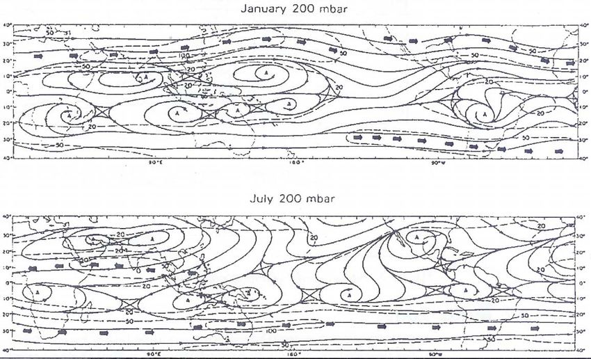
January 200 mbar
July 200 mbar
Figure 2. Mean annual wind flow (streamlines) at 200hPa (c. 12km) in the tropics with vector-mean isotachs (ms–1) shown by dashes. The mean core of
the sub-tropical jet streams is shown by arrows. The effect of using gridded vector-mean speed, as in this case, is to reduce the apparent speed of the
winds, which are instantaneously stronger at all times and in all seasons. (The use of the 200-hPa also omits the strongest winds observed near the
Equator, which develop between the 150-hPa and 100-hPa levels; these are indicated by arrows.) The easterly and westerly branches of the Walker
circulation can be seen close to the Equator. (Adapted from Godbole and Shukla, 1981.)
246
weather fluctuation within about 5–10 °
                                                                                                          latitude of the mean position of the ITCZ.
                                                                                                          However, since most of the world’s hot

                                                                                                                                                                The weather and climate of the tropics
                                                                                                          deserts have their equatorial flank within
                                                                                                          20 ° of the Equator, marked by transition to
                                                                                                          savannah vegetation (e.g. the Sahel of West
                                                                                                          Africa), seasonal variations can be large
                                                                                                          close to these latitudes.
                                                                                                             As can be seen in Figure 1, the pre-
                                                                                                          dominant climates of the tropics are dry
                                                                                                          ones: the hot deserts, semi-desert scrub and
                                                                                                          expansive savannahs. These lie towards the
                                                                                                          periphery of the tropical zone, in regions
                                                                                                          where anticyclonic subsidence predomi-
                                                                                                          nates and rainfall is either seasonal or

                                                                                                                                                             Weather – September 2007, Vol. 62, No. 9
Figure 3. Mean sea-level pressure in the tropics (a) January, (b) July. Over high ground, in particular   ephemeral. The hot deserts are noted for a
the Himalayas, mean sea-level pressure has no meaning, since the surface wind flow is influenced by       high diurnal range of temperature. A maxi-
pressure differences at higher levels. (Adapted from Godbole and Shukla, 1981.)                           mum of more than 40 ° C in places by mid
                                                                                                          afternoon may fall as much as 30 degC by
                                                                                                          morning. This range is solely due to the
                                                                                                          effects of a dry atmosphere with little or no
                                                                                                          cloud and such a low vapour pressure that
30° N and 25° S. North-easterlies in the             tropical jet stream (STJ) along the poleward         diurnal temperatures can vary greatly.
Northern Hemisphere converge near the                edge of the tropical air mass, close to 30° N           Over continental areas, the periphery of
Equator with south-easterlies in the South-          and 30° S. The STJ is present throughout the         the humid zone is dominated by monsoon
ern Hemisphere providing the additional              year in the Southern Hemisphere, but has             wind regimes. These bring wet humid
forcing necessary for deep convection with-          large speed changes between winter and               weather in summer and predominantly dry
in the tropics, forming a belt of convective         summer in the Northern Hemisphere. In the            weather in winter. Characteristically, there is
cloud: the inter-tropical convergence zone           northern winter, its speed may reach                 a seasonal reversal of wind at low levels. In
(ITCZ). However, significant reversals in the        110 ms–1 or more over east Asia and the              the northern summer, southeasterly winds
low-level wind flow occur over and around            western Pacific. However, its speed is rarely        cross the Equator and recurve to become
the tropical continents during the change            more than 50 ms–1 in high summer with a              south-westerlies (north-easterlies become
from winter to summer.                               mean closer to 25 ms–1.                              north-westerlies in the Southern Hemi-
   Summer monsoon circulations have                     At medium levels, winds of moderate               sphere), bringing moist oceanic air across
westerlies at low levels, but middle- and            strength often form wave trains, known as            the Equator into areas that are under the
upper-tropospheric easterlies strengthen as          easterly waves, which form in response to            influence of dry continental easterly winds
the troposphere warms and deepens to                 temperature differences and convective               during the winter. West Africa, southern
form an upper high over the continents, on           development. These have a strong associa-            Asia and northern Australia all experience
the equatorward rim of which there is a              tion with severe weather, notably summer             these monsoon reversals. Although still sea-
steep temperature and height gradient. The           mesoscale weather systems over India, and            sonal, the situation is more complex over
greatest strengthening occurs as the equa-           the squall lines of Africa and parts of the          the Amazon basin and Caribbean, where
torial high migrates away from the Equator           Pacific Ocean (Atkinson, 1971; Leroux,               moist westerlies cannot become estab-
and deepens. Close to the Equator, these             2001). Over the Atlantic, easterly waves are         lished, due to the Andes-Sierra Madre
winds may reach jet stream strength in a             intimately associated with the development           mountain barriers. Thus the motion of con-
shallow layer near 15 km altitude. This jet          of tropical revolving storms (Emanuel 2005).         vection is dependent on more complex
stream is found only about 1000 m below              The low value of the Coriolis force close to         changes in the atmospheric circulation and
the tropical tropopause. During the North-           the Equator presents a difficulty in the             the influence of the Caribbean Sea, which
ern-Hemisphere summer, these winds                   assessment of wind speed and direction, so           warms and cools more than the neighbour-
stretch all the way from South-East Asia to          streamline analysis, rather than conven-             ing Atlantic Ocean.
Africa’s Gold Coast, although the main               tional pressure analysis, is generally used in          Over the warmest ocean areas, the tropics
activity and highest speeds are generally            the tropics, as described in Box 1.                  are characterized by the development of
across the southern tip of India, where                                                                   tropical revolving storms, associated with
speeds occasionally reach 60 ms–1 * and                                                                   strong lower-tropospheric winds and (per-
there is a local minimum over eastern Africa
                                                     The weather patterns and
                                                                                                          haps more importantly) heavy rainfall.
(Hastenrath, 1991). A similar, but weaker, jet       climates of the tropics                                 Although a relatively narrow zone¶ (no
stream forms over New Guinea and Indone-             The tropical region experiences only                 more than about 1500 km wide, except in
sia in response to the warming of Australia          gradual changes in weather patterns and              South-East Asia), it is the humid equatorial
during the southern summer.                          variations are generally small, even between         zone that many associate with the tropics. In
   The easterly winds at high levels diverge         seasons. The main changes are between dry            this zone, rainfall can be relied upon year
north and south away from the upper high             and wet seasons, marked (i) by the north-            round, as the ITCZ is never far away.
that forms close to the Equator. North and           ward and southward movement of the                   Maxima are generally limited to the mid 30s
south of 15° latitude, they become wester-           inter-tropical convergence zone (ITCZ) in
lies (Figure 2). The upper westerlies may            the central (equatorial) portion and (ii) by         ¶ The ITCZ is sometimes seen to split into two
reach jet stream strength to form the sub-           the winter incursion of cooler air at altitude       branches, each of which may be several hundred
*
 Wind speeds in this series are quoted in metres     near the poleward extremes. Even with this           kilometres across. This is notable in the Indian
per second. 1 ms–1 = 2 knots.                        movement, there is almost no seasonal                Ocean and the western Pacific.

                                                                                                                                                                               247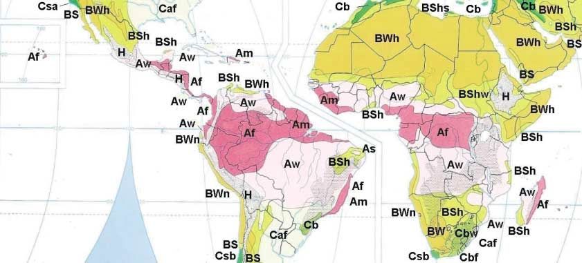
Celsius‡ over land by the high water-vapour             However, within each climatic zone there           This brings a surprisingly cool and usually
                                               content of the air and minima are similarly          are important variations, due to orography,           dry climate north to only a few degrees
                                               restricted by cloudiness or the overnight            latitude and longitude. Some of the world’s           south of the Equator, although this climatic
 The weather and climate of the tropics

                                               formation of dew, mist or fog. Over the sea,         hot deserts receive most of their (meagre)            zone, comparatively equable for the popula-
                                               temperature changes little day by day. Thus,         rainfall in summer, others in winter – here           tion, is narrow, extending only a few tens of
                                               throughout the tropics, the diurnal range of         the variation is mainly by latitude and               kilometres inland. Populations are compara-
                                               temperature is relatively small. Neverthe-           altitude, with equatorward regions having a           tively high in these zones, largely due to the
                                               less, this climate is uncomfortable for most         summer rainfall peak. Examination of the              excellent fishing available, due to the
                                               humans, who find it difficult to lose excess         mean annual rainfall in the tropics reveals           upwelling of plankton-rich deep waters.
                                               body heat in these conditions. Indeed, this          that there are significant differences on a              Heating and cooling have a significant
                                               energy-sapping weather is used as a test by          broad scale within climatic zones, as shown           effect on air pressure throughout the
                                               élite British army and Royal Marines regi-           in Figure 4. In general, the desert areas             tropics, the pressure falling in response to
                                               ments, which carry out part of their training        generally see less than 200 mm yr–1,                  diurnal heating and rising in response to
                                               in Brunei.                                           although Australia’s dry interior is defined          nocturnal cooling. As pressure rarely
                                                  Where seasonality is the main effect on           by annual rainfall less than 600 mm. The              changes due to synoptic-scale weather
    Weather – September 2007, Vol. 62, No. 9

                                               rainfall, savannahs predominate. In these            monsoon zones see between about 1000                  systems in the tropics, the diurnal changes
                                               areas of extensive grassland, annual evapo-          and 2500 mm yr–1, occurring in summer. The            are significant, as shown in Table 1.
                                               ration exceeds precipitation and trees grow          semi-deserts and oceanic areas under the
                                               only in stunted groves. These areas are              influence of the sub-tropical anticyclones
                                                                                                    have a total rainfall between 200 and about
                                                                                                                                                          Clouds and fog in the tropics
                                               home to relatively large populations in
                                               some parts of the world and agriculture is           1000 mm yr–1. Areas under the influence of            Most Weather readers will be familiar with
                                               critically dependent on the summer rains             upper-tropospheric troughs (see Parts 2 and           the clouds observed in the middle latitudes
                                               (both locally and to re-charge river flows), so      3) see about 1000 mm yr–1 and the ITCZ                and their typical range of heights (Pouncy,
                                               any reduction or failure of seasonal rainfall        experiences totals above 1000 mm yr–1 with            2003). The clouds of the tropics are the same
                                               often causes notable famines, especially in          some areas seeing more than 3000 mm yr–1.             types as those seen in the rest of the world,
                                               recent years. Some areas that have some              Orographic effects add further local detail.          although convective clouds are predomi-
                                               seasonality, but a predominantly maritime               High ground has two main effects: it               nant, whilst altostratus and nimbostratus
                                               climate, such as the northern Caribbean,             lowers the mean temperature (although                 are relatively rare. However, the increase in
                                               have an intermediate climate with extensive          nights may be less cool, if the mountains are         the depth of the troposphere means that
                                               forest, as well as grassland. Elsewhere,             modest and the observation is not in a                the range of height at which each species is
                                               steppe surrounds the arid deserts. Here few          valley) and increases the rainfall, increasing        seen is greater than in the middle latitudes.
                                               plants can grow, but there is sufficient rain-       the likelihood of precipitation by ‘forced’           The World Meteorological Organization
                                               fall or run-off to support agriculture and           convection or convergence. For instance,              (WMO) recommends the range of cloud
                                               moderate-sized populations. Included in              copious rainfall is generated by the Ethiopi-         height given in Table 2 (WMO, 1956 ).
                                               this climatic zone are the highlands of much         an Highlands and India’s Western Ghats.                  All stratocumulus clouds† in the tropics
                                               of Arabia.                                           These highlands have a relatively equable             are at a temperature above 0° C and it is
                                                                                                    climate within the almost universally hot             altocumulus and altostratus (as well as occa-
                                               ‡ The ‘rule’ explaining the limitation of tempera-   tropical zone and their climate is markedly           sional nimbostratus) that occupy the level of
                                               ture assumes a boundary layer near saturation.       different from that of their surroundings.
                                               This is comparatively rare, even in the humid
                                                                                                       Along the western margins of Africa and
                                               zone. The humidity mixing ratio (h.m.r.) locally                                                            † This assumes that the cloud height is not
                                                                                                    the Americas, there are cool currents as a
                                               reaches 20 g kg–1 in the humid zone, limiting                                                               relative to the observer. Clearly there are layer
                                               temperatures. However, the May pre-monsoon           result of the upwelling of cool deep water             clouds at heights less than 2000 m above high
                                               season, for instance, brings humid air across        under the influence of the Trade Winds. The            ground in the tropics that are at or below 0°C.
                                               India with an h.m.r. closer to 16 g kg–1, allowing   effect is most marked along the south-west             Typically, this would be the case for an observa-
                                               temperatures to rise to around 40°C under clear      coast of South America, as well as the north-          tion made at an altitude above 2500–4000 m in
                                               skies. In either case, it feels very close!          western and south-western coasts of Africa.            the tropics.

                                               Figure 4. Mean annual rainfall (m) in the tropics (from Hastenrath, 1991, Figure 6.1:7). Local orographic effects are not evident at this scale, although a
                                               rainfall maximum in excess of 2000 mm yr–1 is shown over the southern Himalaya.

248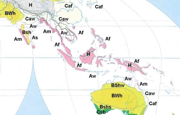
Table 1                                                                                                From cumulus clouds, precipitation is
                                                                                                    generally slight. Nevertheless, this rainfall
Typical pressure changes due to the heating and cooling of the atmosphere in the tropics.           (or, over high mountains, snowfall) can form

                                                                                                                                                         The weather and climate of the tropics
Correction to the observed pressure                Average component of the 3-hourly                the majority of annual precipitation.
necessary to allow for diurnal variation           barometric change due to the                        Stratus and fog are also characteristic of
                                                   diurnal variation                                parts of the tropics. Stratus with hill fog is
Local time    0°–10°N or S 10°–20°N or S           Local time      0°–10°N or S     10°–20°N or S   frequently seen in the early morning over
                HPa             hPa                                     HPa                hPa      tropical woodland, in particular the tropical
0000            –0.6            –0.5               0000-0300            +1.1               +1.0     rainforest, following overnight cooling.
0100            –0.1            –0.1               0100-0400            +0.9               +0.9     Here, transpiration from the trees in a very
0200            +0.3            +0.3               0200-0500            +0.3               +0.3     moist environment assists its formation.
0300            +0.7            +0.7               0300-0600            –0.5               –0.5        Fog and stratus are also features of cooler
0400            +0.8            +0.8               0400-0700            –1.2               –1.1     parts of the tropical oceans and are fre-
0500            +0.6            +0.6               0500-0800            –1.5               –1.4     quently seen along the east-facing coasts of
0600            +0.2            +0.2               0600-0900            –1.5               –1.3     southern Africa and South America. In the

                                                                                                                                                      Weather – September 2007, Vol. 62, No. 9
0700            –0.4            –0.3               0700-1000            –1.0               –0.9     former case, much of the meagre precipita-
0800            –0.9            –0.8               0800-1100            –0.2               –0.4     tion available for plants to grow in the
0900            –1.3            –1.1               0900-1200            +0.7               +0.6     Namib Desert is deposited from wet fogs.
1000            –1.4            –1.2               1000-1300            +1.5               +1.3        Early-morning fog is also relatively com-
1100            –1.1            –1.0               1100-1400            +1.8               +1.7     mon on the coasts of the Arabian Gulf,
1200            –0.6            –0.5               1200-1500            +1.9               +1.6     where sea breezes frequently bring moist air
1300            +0.1            +0.1               1300-1600            +1.4               +1.2     inland during the afternoon, humidifying
1400            +0.7            +0.7               1400-1700            +0.7               +0.5     the air and raising its fog point. Extreme
1500            +1.3            +1.1               1500-1800            –0.3               –0.2     summer cases (observed in Doha and
1600            +1.5            +1.3               1600-1900            –1.0               –1.0     Bahrain), when sea-surface temperatures in
1700            +1.4            +1.2               1700-2000            –1.5               –1.4     the Gulf may reach 35° C, may bring fog with
1800            +1.0            +0.9               1800-2100            –1.6               –1.5     visibility less than 100 m around dawn with
1900            +0.5            +0.3               1900-2200            –1.4               –1.1     air temperatures and dew points above
2000            –0.1            –0.2               2000-2300            –0.8               –0.6     30° C (Andy Dexter, Richard Young personal
2100            –0.6            –0.6               2100-2400             0.0               +0.1     communications)! These fogs feel very
2200            –0.9            –0.8               2200-0100            +0.8               +0.7     moist, almost suffocating, making it difficult
2300            –0.9            –0.8               2300-0200            +1.1               +1.0     for humans and animals to lose excess heat.
                                                                                                    As such, they can be dangerous to life in a
                                                                                                    very different way from fogs in the middle
Table 2                                                                                             latitudes.
                                                                                                       Layer clouds are usually the product of
The variation of range of cloud-base heights in tropical, middle-latitude and polar air masses.     convection and are often relatively thick, as
Étage                        Polar regions            Middle latitudes           Tropical regions   a result. Most of these clouds of convective
High (Ci, Cs, Cc)            3000–8000 m              5000–13000 m                6000–18000 m      origin are of genera altocumulus or strato-
                                                                                                    cumulus. However, there are some excep-
Middle (Ac, As, Ns*)         2000–4000 m              2000–7000 m                 2000–8000 m
                                                                                                    tions and altostratus or nimbostratus
Low (St, Sc, Cu, Cb)         0–2000 m                 0–2000 m                    0–3000 m          sometimes form, usually in association with
* Nimbostratus usually has a base that extends down into the low-cloud étage and a top that is      cyclonic disturbances. These will be dis-
  frequently well into the high-cloud étage.                                                        cussed later in the series. Hours of steady
                                                                                                    precipitation may fall from these deep layer
                                                                                                    clouds.
                                                                                                       Altocumulus castellanus (or floccus)
transition to supercooled water. The tops of       from air with a high humidity mixing ratio       clouds are also characteristic of tropical air.
the deepest medium-level clouds may                (r ∪ 20 g kg–1 in the ITCZ), can produce large   Principally, they form in response to high-
contain a significant amount of ice as the         amounts of precipitable water and are the        level cooling. This occurs in two ways. First,
temperature of the cloud falls below about         source of thunderstorms of the ITCZ. Thun-       there is the dynamical cooling associated
–20° C. This temperature occurs at an              derstorms are frequently seen in association     with advection, often ahead of upper
altitude between 8 km and, locally, 9 km.          with the deep convection of the tropics.         troughs. This is usually evident above the
Clouds formed predominantly of ice are not         However, they are more common near the           700-hPa level. Second, there is the long-
found below 8 km in the tropics.                   poleward edge of the ITCZ, where instability     wave cooling of the atmosphere during the
   Cumulonimbus clouds always have tops            and convective available potential energy        evening, causing a decrease in stability at
extending into the middle levels and fre-          (CAPE) values (defined in Galvin et al., 1995)   the cloud tops. Castellanus development
quently into the high-cloud étage. This is         are larger than nearer to the Equator, espe-     may prolong the life of cumulonimbus
the usual state in the tropics, where cumu-        cially over the continents (see Figure 5).       through the night. In some cases, the de-
lonimbus clouds rarely have tops below             Despite the presence of cumulonimbus,            stabilization is associated with instability at
12 km. In hot-desert regions, where there is       which may produce hail, much of the tropics      lower levels, which feeds into the unstable
sufficient moisture, cumulus or, if there is       is simply too warm for hail to reach the         medium-level clouds.
sufficient moisture at high levels, cumu-          ground, although it does occur in places            Any unstable cloud whose top becomes
lonimbus clouds, may form around the time          where wind shear and vorticity are con-          glaciated is reclassified as cumulonimbus.
of maximum temperature.                            ducive. Waterspouts and tornadoes may            Thus the base of these cumulonimbus
   Precipitation from cumulonimbus clouds          also form, but only where there is sufficient    clouds, originally altocumulus castellanus,
is usually heavy. These clouds, resulting          vorticity.                                       may be at 4000 to 5000 m or more. Most                              249
thunderstorms that develop over the hot
deserts of the tropics have such high bases.
Precipitation from these high-based cumu-
The weather and climate of the tropics
lonimbus clouds usually evaporates before
reaching the ground and strong down-
draughts are the result.
Population in the tropics
On average, population density is low in
the tropics: typically around 10 per km2.
However, in India, Bangladesh, southern
China and parts of South-East Asia, the
population density is much higher, reaching
Weather – September 2007, Vol. 62, No. 9
100 per km2 or more.
Away from rivers, the hot-desert environ-
ment is not able to support large popula-
tions and tropical rain forest is a dark
foreboding environment with trees that are
difficult to clear, unless heavy machinery is
available. Thus populations are found
mainly along coasts or rivers, where trans-
port has been available for centuries or
millennia. It is near the mouths of the larger
rivers that the largest cities are found.
The savannahs are moderately populated,
the land easy to clear for agriculture and
road building. However, in some areas the
population density is close to the ability of
the land to support it. In Africa and parts of
South America, this presents a problem,
since populations have grown rapidly
Figure 5. Radiosonde profile for Niamey, Niger, in Africa's Sahel at 1200 UTC on 30 July 2006. This during the late twentieth century and the
ascent is absolutely unstable and has a convective cloud base near 850 hPa, in contrast to ascents rainfall is not sufficiently reliable in these
typical of the ITCZ. It shows a typically high level of CAPE (1273 J kg–1) and θw falling with height. areas for there to be confidence that popu-
lations can survive without a major risk of
drought and famine.
The degree of urbanization, by contrast,
varies considerably from continent to conti-
Box 1. The effect of latitude on geostrophic balance nent. In South America, it is generally above
Over much of the globe, wind speed and direction are the result of a balance of forces, 50%, the proportion in Venezuela above
the most significant of which are the pressure-gradient force and the Coriolis force, 90% and in Australasia 80%. But in much of
which are in equilibrium where the flow is straight and parallel to the Equator (Persson, Asia and Africa it is below 45%, Ethiopia,
2000). However, this relationship breaks down close to the Equator, where the Coriolis Uganda, Malawi and Nepal having fewer
force becomes very small, since the air is subject to very little rotation around the Earth’s than 15% of their populations living in
axis. towns. This stresses the relative importance
Nevertheless, winds remain in reasonable balance until they reach the latitudes of of agriculture in these countries, even those
about 6° and even then momentum generally carries the wind in the direction it was that are rapidly industrializing, such as India
moving when in near-geostrophic balance. Bigger problems for the analyst include the and China. However, there are significant
distance between isobars, which become very large in the tropics, such that barometric variations from country to country and with-
errors (and those of correction to sea level) make standard analysis, based on mean sea- in countries.
level pressure (or geopotential height), almost impossible. As a result, most analysis in
the tropics uses streamlines.
If we define the tropics as the zone between the sub-tropical discontinuities, the
tropical atmosphere is barotropic, so horizontal temperature differences are small. Fur-
El Niño and the Southern
thermore, the apparent progress of the sun from east to west across the sky causes a Oscillation
pressure disturbance as the air is heated and cooled by incoming and outgoing radia- The El Niño phenomenon is generally
tion. The wavelength of this disturbance is 12 hours and its amplitude is approximately accepted to have a profound underlying
2 hPa at the surface (Table 1); the amplitude is somewhat larger than the usual change effect in the tropics, changing the broad-
of pressure in the atmosphere. scale circulation patterns as pressure
Over land areas, the use of mean sea-level pressure is also inappropriate since the changes across the Pacific to form the
correction of observed pressure to sea level causes errors. Thus, where geostrophic Southern Oscillation. The Southern Oscilla-
balance needs to be measured, the height of the 925 hPa or 850 hPa surface should be tion is a relative change of pressure in the
used. eastern tropical Pacific basin (usually meas-
ured at Tahiti) compared with that in the
250west (measured at Darwin). El Niño is a A review of El Niño and its global con- Hastenrath S. 1991. Climate Dynamics of
warming of the eastern equatorial Pacific sequences appeared as a special issue of the Tropics. Kluwer Academic Publishers,
Dordrecht.
Ocean and causes mean sea-level pressure Weather in 1998 (Vol. 53, No. 9), so no more
The weather and climate of the tropics
to fall over the eastern Pacific, whereas over will be said here. Leroux M. 2001. The Meteorology and Cli-
mate of Tropical Africa. Springer/Praxis,
the western Pacific, pressure rises. Chichester.
The consequence of the changes is to
increase precipitation in the eastern Pacific
References Persson A. 2000. Back to basics: Coriolis.
Part 3. The Coriolis force on the physical
(and over the Atlantic and western Indian Atkinson GD. 1971. Forecasters’ Guide to earth. Weather 55: 234–239.
Tropical Meteorology. University Press of
Ocean basins), while decreasing it across the Pacific, Honolulu. Pouncy FJ. 2003. A history of cloud codes
South-East Asia and Australia (as well as, and symbols. Weather 58: 69–72, 77–80.
Emanuel K. 2005. Divine Wind: The History
perhaps, east Africa). and Science of Hurricanes. Oxford Universi- Riehl H. 1979. The Climate and Weather of
Relatively strong westerlies are associated ty Press, New York. the Tropics. Academic Press, London.
with the development of the El-Niño anom- Fedorov AV. 2002. The response of the Verbickas S. 1998. Westerly wind bursts
alies in the eastern Pacific (Verbickas, 1998; coupled tropical ocean-atmosphere to in the tropical Pacific. Weather 53:
westerly wind bursts. Q. J. R. Meteorol. Soc. 282–284.
Fedorov, 2002) and their formation mecha-
WMO. 1956. International cloud atlas.
Weather – September 2007, Vol. 62, No. 9
128: 1–23.
nism seems to be directly linked with the Abridged atlas. Geneva.
El-Niño phenomenon. In view of the mass Fleming RJ. 1986. The Tropical Ocean and
Global Atmosphere programme. ICSU and WMO. 1982. Manual on the Global Data-
transport associated with such a change in WMO International TOGA Project Office, Processing System. Geneva.
wind velocity, accompanied by the vast Boulder.
amount of water vapour that can be carried Fuller SR. 2004. Recent forecast model
by such tropical winds, it is easy to see how improvements. NWP Gazette, June 2004,
El Niño has global consequences. 10. Correspondence to: Jim Galvin, Met Office,
La Niña is an amplification of the west- Galvin JFP, Bennett PH, Couchman PB. FitzRoy Road, Exeter EX1 3PB.
ward flow of the Trade Winds and associat- 1995. Two thunderstorms in summer 1994 Email: jim.galvin@metoffice.gov.uk
at Birmingham. Weather 55: 237–250.
ed increased warmth of the western Pacific. © Crown Copyright, 2007.
It is measured as an increase from the nor- Gates WL, Newson RL. 2006. World Cli-
mate Research Programme: a history. DOI: 10.1002/wea.53
mal pressure difference Tahiti–Darwin. Its WMO Bull. 55: 210–216.
consequences are an increase in west Pacif- Godbole RV, Shukla J. 1981. Global
ic tropical storm activity and copious addi- analysis of mean sea-level pressure. NASA
tional rainfall across South-East Asia and Tech. Memo. 82097. Goddard Space Flight
north-eastern Australia. Centre, Greenbelt.
A particularly threatening advancing squall line, as seen from Stratfield Mortimer, Berkshire, looking south-west at
1812 UTC on 19 August 2006. The surface dew point temperature fell rapidly, 2.5 degC in 7 minutes, as the leading edge
of the squall line passed overhead; this was followed by two hours of showery rain starting a few minutes after the
photograph was taken. (© Stephen Burt.)
251You can also read