THEAKSTON ENVIRONMENTAL - City of Mississauga
←
→
Page content transcription
If your browser does not render page correctly, please read the page content below
THEAKSTON ENVIRONMENTAL
       Consulting Engineers Environmental Control Specialists

                                    REPORT

           FINAL PEDESTRIAN LEVEL WIND STUDY

                         5081 Hurontario Street
                                     Phase II

                           MISSISSAUGA, ONTARIO

                    5081 Hurontario Limited Partnership

         REPORT NO. 20616wind                      October 26, 2020

An International Reputation for Excellence
TABLE OF CONTENTS

1. EXECUTIVE SUMMARY ...............................................................................................1
2. INTRODUCTION .............................................................................................................3
3. OBJECTIVES OF THE STUDY .....................................................................................3
4. METHOD OF STUDY......................................................................................................4
   4.1      GENERAL .......................................................................................................................4
   4.2      METEOROLOGICAL DATA ..............................................................................................5
   4.3      STATISTICAL WIND CLIMATE MODEL ...........................................................................5
   4.4      WIND SIMULATION ........................................................................................................5
   4.5      PEDESTRIAN LEVEL WIND VELOCITY STUDY ................................................................5
   4.6      PEDESTRIAN COMFORT CRITERIA ..................................................................................6
   4.7      PEDESTRIAN SAFETY CRITERIA .....................................................................................7
   4.8      PEDESTRIAN COMFORT CRITERIA – SEASONAL VARIATION ..........................................8
5. RESULTS ...........................................................................................................................8
   5.1 STUDY SITE AND TEST CONDITIONS ..............................................................................8
   5.2 PEDESTRIAN LEVEL WIND VELOCITY STUDY ..............................................................11
   5.3 REVIEW OF PROBE RESULTS ........................................................................................12
     Public Street Conditions....................................................................................................13
     Interior Courtyard, Vehicular Drop-Off, and Northwest Sidewalk Conditions ................16
     Landscaped Outdoor Amenity Areas.................................................................................16
     Pedestrian Entrance Conditions .......................................................................................18
6. MITIGATION STRATEGIES.......................................................................................18
7. SUMMARY......................................................................................................................19
8. FIGURES .........................................................................................................................21
9. APPENDIX A ..................................................................................................................62
10.      REFERENCES.............................................................................................................74

      Theakston
      Environmental
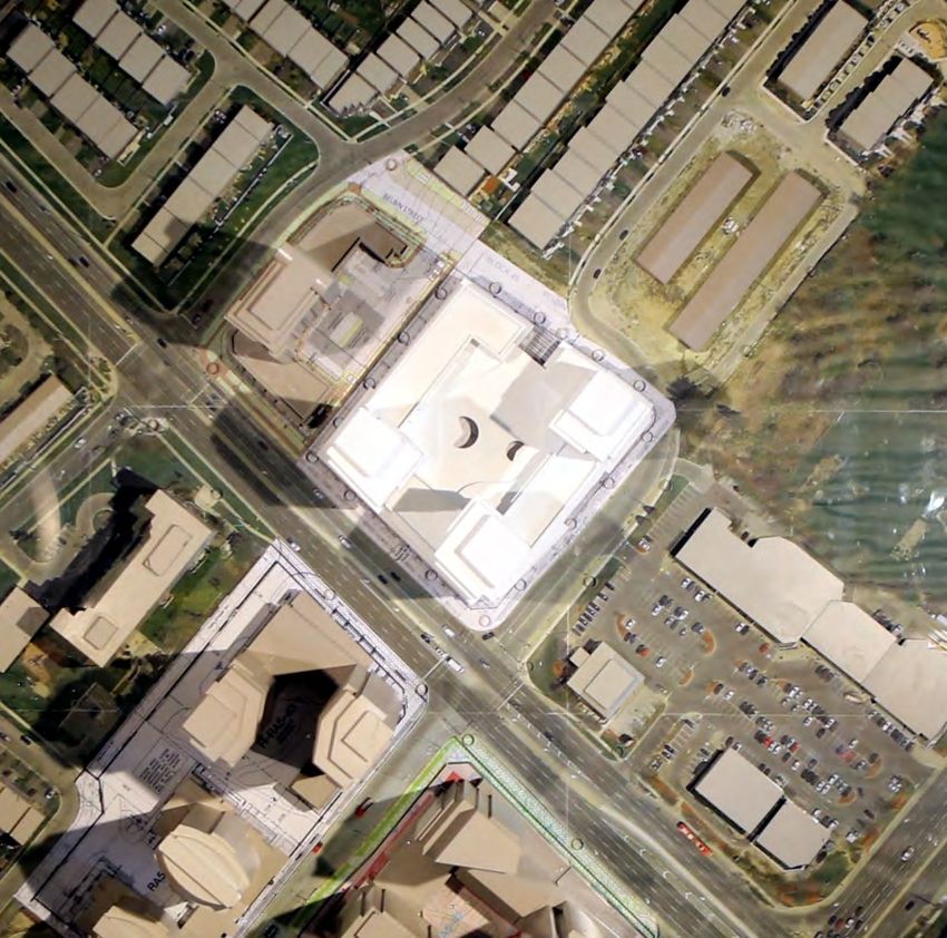
1

1. EXECUTIVE SUMMARY
The 5081 Hurontario Street Phase II Residential Development proposed by 5081 Hurontario
Limited Partnership for their property situated at the northeast corner of the intersection of
Hurontario Street with Armdale Road, in the City of Mississauga, has been assessed for
environmental standards with regard to pedestrian level wind relative to comfort and safety. The
pedestrian level wind and gust velocities predicted for the locations tested are within the safety
criteria and through application of the mitigation plan described herein, are within the comfort
criteria described by the City of Mississauga.
The 5081 Hurontario Street Development involves a proposal for phased construction of three
buildings. Phase I is in the final stages of SPA approval and for assessment purposes was assumed
approved. Phase I is comprised of a 33 storey residential tower, denoted Building A, that includes
a 6 storey wing and occupies the northwest portion of the site. Phase II, the subject site, involves a
proposal for construction of 42 and 21 storey residential towers, denoted Buildings B and C,
occupying the southeast portion of the site. Building B is connected to Buildings A and C by 6
storey connective podiums in a C-shaped configuration. The buildings are set about an internal
courtyard that is accessed from Armdale Road and Belbin Street, and is covered at the second
level. Rooftop outdoor amenity spaces are proposed at the 7th level atop the connective podiums
and the second level above the internal courtyard.
The Development is, for all intents and purposes, surrounded to prevailing windward directions
by an urban/suburban mix of institutional, residential and commercial development, related open
areas slated for urban intensification, and mature vegetation. These buildings and related open
areas have a sympathetic relationship with the pending wind climate.
Urban development provides turbulence inducing surface roughness that can be wind friendly,
while open settings afford wind the opportunity to accelerate as the wind’s boundary layer profile
thickens at the pedestrian level, owing to lack of surface roughness. High-rise buildings typically
exacerbate wind conditions within their immediate vicinity, to varying degrees, by redirecting
wind currents to the ground level and along streets and open areas. Transition zones from open
to urban and to a lesser degree suburban, settings may prove problematic, as winds exacerbated
by the relatively more open settings are redirected to flow over, around, and between urban
buildings.
These phenomena were observed at the site with winds that have opportunity to accelerate over
the relatively open lands associated with Hurontario Street, the intersection with Ceremonial
Drive / Nahani Way and along Ceremonial Drive. This relatively open streetscape accounts for
the moderately windy conditions observed at the Hurontario Street intersection with Watergarden
Drive and Armdale Road and along a portion of the pedestrian walkway proposed along the
northwest property line with inclusion of the proposed Phase II Development. The Phase II
Development penetrates winds that formerly flowed over the more open existing lands. These
winds are redirected, tending to split with portions flowing over, around and down the proposed
buildings’ façades. At the pedestrian level, the winds redirect to travel horizontally along the
buildings, around the corners and beyond, creating minor windswept areas at, or near, the
buildings’ corners and along adjacent streets, and these conditions are primarily attributable to
the setting.

   Theakston
   Environmental
2
Winds emanating from remaining compass points are more effectively mitigated, though to
varying degrees, by the local surrounds, and as such, upon impact with the proposed, tend to
split, flowing over, and to a lesser extent around and down the buildings’ faces. At the podium
levels, the winds redirect to travel horizontally along the roofs of the podium, around the corners
and beyond, with limited influence upon pedestrian comfort conditions.
These phenomena result in:
wind conditions along Hurontario Street that are annually appropriate for standing,
walking, or better,
pedestrian comfort conditions along Armdale Road and Belbin Street that are predicted
annually suitable for standing or sitting, appropriate to the intended purpose,
wind conditions along Neighbouring Streets that are removed from the proposed
Development that are annually suitable for walking, standing, or better, appropriate to the
intended purpose,
wind conditions in the Interior Courtyard that are predicted comfortable, suitable to the
intended purpose,
wind conditions along the Northwest Sidewalk that are annually suitable for standing or
walking,
seasonally appropriate comfort conditions at the proposed Amenity Spaces, with
incorporation of the wind mitigation plan that is discussed within, and
wind conditions at the Main Entrances that are suitable for sitting, and appropriate to
the intended purpose,
localised windy conditions at or near building corners along Nahani Way, Armdale Road,
and the northwest sidewalk that are rated uncomfortable on the occasion of high ambient
winter winds, but are at the transition to walking conditions and with consideration of
fine design and landscape elements that include setbacks, canopies, 2.0m high wind
screens, and others, will be appropriate to the intended purpose,
The proposed Phase II Development employs podiums, canopies, recessed entrances, balconies,
stepped façades, overhangs, landscaping, and other wind mitigative devices that will deflect or
otherwise redirect downwash prior to its influencing the surroundings. These, in concert with
surface features that are too fine to incorporate into the model, and future urban development,
will improve predicted pedestrian comfort conditions. The Development is predicted to realise
conditions suitable to a typical suburban/urban context.
Respectfully submitted,
Stephen Pollock, P. Eng.
Paul Kankainen, M.A.Sc.
Nicole Murrell, M.Eng.
Theakston
Environmental
3
2. INTRODUCTION
Theakston Environmental was retained by Liberty Developments on behalf of 5081 Hurontario
Limited Partnership to study the pedestrian level wind environment for Phase II of their proposed
mixed-use residential Development occupying a portion of the block of lands situated northeast of
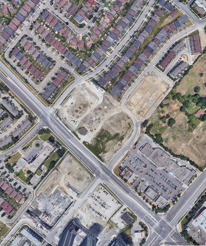
the intersection of Hurontario Street with Armdale Road. The Development will be located in the
City of Mississauga, with the site as depicted on the Aerial Photo in Figure 2a. The project involves
a proposal to construct Phase II of a phased development with Phase I in the final stages of SPA
approval and comprised of a 33 storey residential tower, denoted Building A, that includes a 6 storey
wing, and occupies the northwest portion of the site. Phase II involves a proposal for construction
of 42 and 21 storey residential towers, denoted Buildings B and C, occupying the southeast portion
of the site. Building B is connected to Buildings A and C by 6 storey connective podiums in a C-
shaped configuration. The buildings are set about an internal courtyard that is accessed from
Armdale Road and Belbin Street, and is covered at the second level, as indicated in Figure 2b.
Mr. Mark Liddy, P. Eng., Liberty Development Corporation initiated the request, and Dialog
provided drawings. The co-operation and interest of the Client and their sponsors in all aspects
of this study is gratefully acknowledged.
The specific objective of the study is to determine areas of higher than normal wind velocities
induced by the shape and orientation of the proposed buildings and surroundings. The wind
velocities are rated in accordance with the safety and comfort of pedestrians, notably at entrances
to the buildings, sidewalks, courtyards on the property, as well as other buildings in the
immediate vicinity.
In order to obtain an objective analysis of the wind conditions for the property, the wind
environment was tested in two configurations. The existing configuration included Phase I of
the Development as well as existing and proposed buildings in the surrounding area. The
proposed configuration included the Development's Phase II subject buildings. Mitigation
procedures were assessed during these tests to determine their impact on the various wind
conditions.
The laboratory techniques used in this study are established procedures that have been
developed specifically for analyses of this kind. The methodology, summarized herein,
describes criteria used in the determination of pedestrian level wind conditions. The facilities
used by Theakston are ideal for observance of the Development at various stages of testing, and
the development of wind mitigation measures, if necessary.
3. OBJECTIVES OF THE STUDY
1. To quantitatively assess, by model analyses, the pedestrian level wind
environment under existing conditions and future conditions with the
Development.
Theakston
Environmental
4

            2. To recommend mitigation where the pedestrian comfort results prove
               inappropriate to the intended purpose, and work with the Client to develop
               appropriate solutions.

            3. To assess mitigative solutions.

            4. To publish a Consultant’s report documenting the findings and
               recommendations.

4. METHOD OF STUDY
4.1 General

The Theakston Environmental wind engineering facility was developed for the study of, among
other sciences, the pedestrian level wind environment occurring around buildings, with focus on
the safety and comfort of pedestrians. To this end, physical scale models of proposed
Development sites, and immediate surroundings, are built, instrumented and tested at the facility
with resulting wind speeds measured for different wind directions at various locations likely to
be frequented by pedestrians. This quantitative analysis provides predictions of wind speeds for
various probabilities of occurrence and for various percentages of time that are ultimately
weighted relative to a historical range of wind conditions, and provided to the client.

The techniques applied to wind and other studies carried out at the facility, utilise a boundary
layer wind tunnel and/or water flume (Figure 1). The testing facility has been developed for these
kinds of environmental studies, and has been adapted with equipment, testing procedures and
protocols, in order to provide results comparable to full scale. The Boundary Layer Wind Tunnel
lends itself well to the simultaneous acquisition of large data streams while the water flume is
excellent for flow visualisation.

The purpose of this Pedestrian Level Wind Study is to evaluate the pedestrian level wind speeds
for a full range of wind directions. To accomplish this, the wind’s mean speed boundary layer
profiles are simulated and applied to a site-specific model under test, instrumented with
differential pressure probes at locations of interest. During testing, pressure readings are taken
over a one-hour model scale period of time, at a full-scale height of approximately 1.8m and
correlated to mean and gust wind speeds, expressed as ratios of the gradient wind speed.

The mean and gust wind speeds at the forty-four (44) points tested were subsequently combined
with the design probability distribution of gradient wind speed and direction, (wind statistics)
recorded at Airports in the vicinity, to provide predictions of the full-scale pedestrian level wind
environment. Predictions of the full-scale pedestrian level wind environment are presented as the
wind speed exceeded 20% of the time, based on annual, and wind for the seasons in Figures 6a –
6e. Criterion employed by Theakston Environmental was developed by others and us and
published in the attached references. The methodology has been applied to over 800 projects on
this continent and abroad.

    Theakston
    Environmental
5

4.2 Meteorological Data

The wind climate for the Mississauga region that was used in the analysis was based on historical
records of wind speed and direction measured at Pearson International Airport for the period
between 1980 and 2017. The meteorological data includes hourly wind records and annual
extremes. The analysis of the hourly wind records provides information to develop the statistical
climate model of wind speed and direction. From this model, predicted wind speeds regardless
of wind direction for various return periods can be derived. The record of annual extremes was
also used to predict wind speeds at various return periods. Based on the analysis of the hourly
records, the predicted hourly-mean wind speed at 10m, corrected for a standard open exposure
definition, is 25m/s for a return period of 50 years.

4.3 Statistical Wind Climate Model

For the analysis of the data, the wind climate model is converted to a reference height of 500m
using a standard open exposure wind profile. The mean-hourly wind speed at a 500m reference
height used for this study is 45.6m/s for a return period of 50 years. The corresponding 1-year
return period wind speed at the 500m height is 36m/s.

The design probability distribution of mean-hourly wind speed and wind direction at reference
height is shown for Pearson International Airport in Figure 5. Both annual and seasonal
distributions are shown. From this it is apparent that winds can occur from any direction,
however, historical data indicates the directional characteristics of strong winds are north through
west to southwest and said winds are most likely to occur during the winter, spring and fall
seasons.

4.4 Wind Simulation

To simulate the correct macroclimate, the upstream flow passes over conditioning features placed
upstream of the model, essentially strakes and an appropriately roughened surface, as required to
simulate the full-scale mean speed boundary layer approach flow profiles occurring at the site.

4.5 Pedestrian Level Wind Velocity Study

A physical model of the proposed Development and pertinent surroundings, including existing
buildings, roadways, pathways, terrain and other features, was constructed to a scale of 1:500.
The model is based upon information gathered during a site visit to the proposed Development
site, and surrounding area. Dialog provided architectural drawings. City of Mississauga aerial
photographs were also used in development of the model to ensure the model reasonably

    Theakston
    Environmental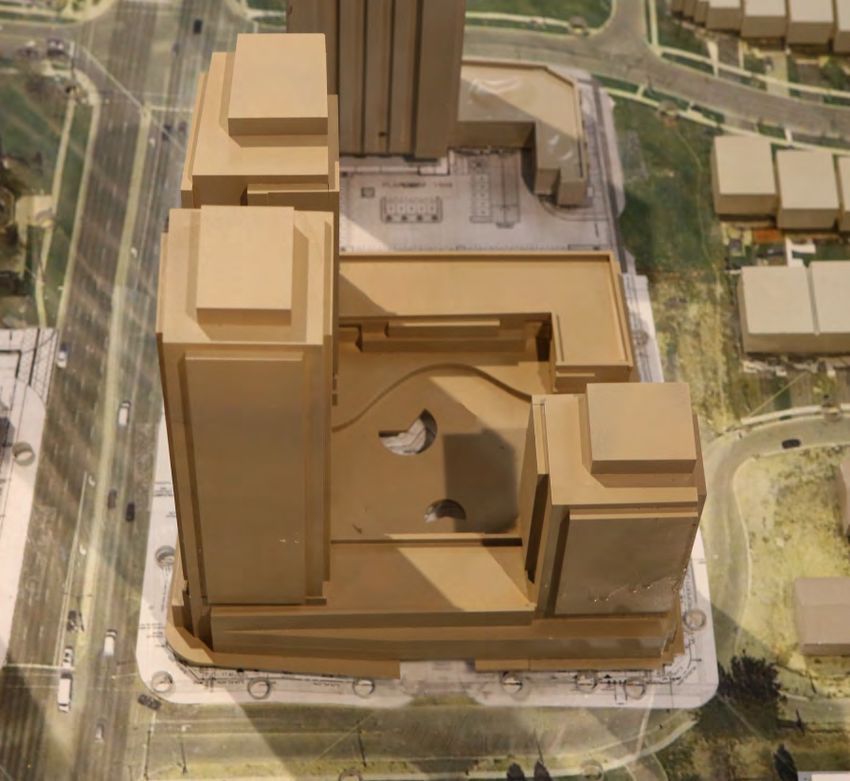
6

represents conditions at the proposed Development. The model is constructed on a circular
base so that, by rotation, any range of wind directions can be assessed. Structures and features
that are deemed to have an impact on the wind flows are included upwind of the scale model.

In these studies, the effects of wind were analysed using omni-directional wind velocity probes
that are placed on the model and located at the usual positions of pedestrian activity. The
probes measure both mean and fluctuating wind speeds at a height of approximately 1.8m.
During testing, the model sample period is selected to represent 1hr of sampling time at full
scale. The velocities measured by the probes are recorded by a computerized data acquisition
system and combined with historical meteorological data via a post-processing program.

4.6 Pedestrian Comfort Criteria

The assignment of pedestrian comfort takes into consideration pedestrian safety and comfort
attributable to mean and gust wind speeds. Gusts have a significant bearing on safety, as they can
affect a person’s balance, while winds flowing at or near mean velocities have a greater influence
upon comfort.

Figure 6 presents results for the mean wind speed that is exceeded 20% of the time. These speeds
are directly related to the pedestrian comfort at a particular point. The overall comfort rating, for
existing and proposed, are depicted in Figure 7. Table 1, below, summarizes the comfort criteria
used in the presentation of the results depicted in Figures 6 and 7.

Table 1: Comfort Criteria
                            Gust Equivalent Mean
    ACTIVITY                Speed Exceeded 20% of                     Description
                                   the Time
  COMFORT                   km/h         m/s
                                           (used in
                                            Fig. 6)
  Sitting                   0-10          0-2.8         Calm or light breezes desired for
                                                        outdoor restaurants and seating areas
                                                        where one can read a paper without
                                                        having it blown away.
  Standing                  0-15          0-4.2         Gentle breezes suitable for main
                                                        building entrances and bus stops.
  Walking                   0-20          0-5.6         Relatively high speeds that can be
                                                        tolerated if one’s objective is to walk,
                                                        run or cycle without lingering.
  Uncomfortable             >20           >5.6          Strong winds of this magnitude are
                                                        considered a nuisance for most
                                                        activities, and wind mitigation is
                                                        typically recommended.

    Theakston
    Environmental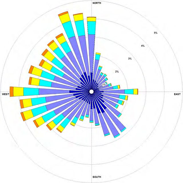
7

The activities are described as suitable for Sitting, Standing, Walking, or Uncomfortable,
depending on average wind speed exceeded 20% of the time. For a point to be rated as suitable
for Sitting, for example, the wind conditions must not exceed 10km/h (2.8m/s), more than 20% of
the time. Thus, in the plots (Figure 6), the upper limit of each bar ends within the range described
by the comfort category. For sitting, the rating would include conditions ranging from calm up
to wind speeds that would rustle tree leaves or wave flags slightly, as presented in the Beaufort
Scale included in the Appendices. As the name infers, the category is recommended for outdoor
space where people might sit for extended periods.
The Standing category is slightly more tolerant of wind, including wind speeds from calm up to
15km/h (4.2m/s). In this situation, the wind would rustle tree leaves and, on occasion, move
smaller branches while flags flap. This category would be suitable for locations where people
might sit for short periods or stand in relative comfort. The Walking category includes wind
speeds from calm up to 20km/h (5.6m/s). These winds would set tree limbs in motion, lift leaves,
litter and dust, and the locations are suitable for activity areas. The Uncomfortable category
covers a broad range of wind conditions that are generally a nuisance for most activities, including
wind speeds above 20km/h (5.6m/s).

In Figure 6, the probe locations are listed along the bottom of the chart; beneath the graphical
representation of the Mean Wind Speed exceeded 20% of the time. Along the right edge of the
plot the comfort categories are shown. The background of the plot is lightly shaded in colours
corresponding to the categories shown in Table 1. Each category represents a 5km/h (or more)
interval. The location is rated as suitable for Sitting, Standing, Walking, or Uncomfortable, if the
bar extends into the corresponding interval.
The charts represent the average person’s response to wind force annually and for four seasons.
Effects such as wind chill and humidex (based on perception) are not considered. Also clothing
is not considered, since clothing and perceived comfort varies greatly among the population.
There are many variables that contribute to a person’s perception of the wind environment beyond
the seasonal variations presented. While people are generally more tolerant of wind during the
summer months, than during the winter, due to the wind cooling effect, people become
acclimatized to a particular wind environment. Persons dwelling near the shore of an ocean, large
lake or open field are more tolerant of wind than someone residing in a sheltered wind
environment.

4.7 Pedestrian Safety Criteria
Safety criteria are also included in the analysis to ensure that strong winds do not cause a loss of
balance to individuals occupying the area. The safety criteria are based on wind speeds exceeded
nine times per year as shown in Table 2.

Both the Comfort and Safety Criteria are based on those developed at the Allan G. Davenport
Wind Engineering Group Boundary Layer Wind Tunnel Laboratory, located on the campus of
The University of Western Ontario. The comfort criteria were subsequently revised for the

    Theakston
    Environmental
8

Mississauga Urban Design Terms of Reference for Wind Comfort and Safety Studies, in
consultation with RWDI and more closely respects the Lawson criteria.

Table 2: Safety Criteria
                             Mean Wind Speed
   ACTIVITY
                          Exceeded 9 times per year                   Description
  SAFETY                   km/h         m/s
                                          (used in
                                           Fig. 8)
  All-Weather              0-90            0-25         Acceptable gust speeds that will not
                                                        adversely affect a pedestrian’s balance
                                                        and footing.
  Exceeding All-           >90             >25          Excessive gust speeds that can adversely
  Weather                                               affect a pedestrian’s balance and
                                                        footing. Wind mitigation is typically
                                                        required.

4.8 Pedestrian Comfort Criteria – Seasonal Variation

The level of comfort perceived by an individual is highly dependent on seasonal variations of
climate. Perceived comfort is also specific to each individual, and depends on the clothing
choices. The comfort criterion that is being used averages the results across the general
population to remove effects of individuals and clothing choices, however, seasonal effects are
important. For instance, a terrace or outdoor amenity space may have limited use during the
winter season, but require acceptable comfort during the summer.

The comfort of a site is based on the “annual” results of the study, Figures 6a and 7a and 7b. In
cases where seasonal comfort is important, results have been included for the seasons; winter,
spring, summer, and fall (see Figures 6b to 6e and Figures 7c to 7j).

When compared to the annual average wind speed, winter winds are about 12.5% higher and
summer winds are about 16% lower.

5. RESULTS
5.1 Study Site and Test Conditions

Proposed Development
The 5081 Hurontario Street Development involves a proposal for phased construction of three
buildings. Phase I is in the final stages of SPA approval and is comprised of a 33 storey residential
tower, denoted Building A, that includes a 6 storey wing with rooftop amenity space, and occupies

   Theakston
   Environmental
9 the northwest portion of the site. Phase I was included in the existing configuration as it is in the final stages of SPA approval and will be constructed prior to Phase II. Phase II involves a proposal for construction of 42 and 21 storey residential towers, denoted Buildings B and C, occupying the southeast portion of the site. Building B is connected to Buildings A and C by 6 storey connective podiums in a C-shaped configuration. The buildings are set about an internal courtyard shared with Phase I that is accessed from Armdale Road and Belbin Street, and is covered at the second level. Rooftop outdoor amenity spaces are proposed at the 7th level of the connective podium between Buildings B and C and the second level above the internal courtyard. The main residential entrance to Buildings A and B is accessed via the connective podium from Hurontario Street and the main residential entrance to Building C is accessed via Armdale Road. Various secondary and live/work entrances are accessed from within the courtyard and along the flanking streets, as indicated in the Figure 2b, Site Plan. The Development, located in the City of Mississauga, is depicted in the Aerial Photo in Figure 2a. Note: Mississauga’s street orientation is relative to the Lake Ontario Shoreline resulting in east/west orientated streets in the subject area being offset by approximately 50 degrees north. 5081 Hurontario Street Development Site Looking North Theakston Environmental
10

Surrounding Area
The proposed Development site, for all intents and purposes, is surrounded to prevailing
windward directions by urban/suburban development, related open areas, and vegetation, as
indicated in Figure 2a. A 10 storey apartment building is situated to the west at 20 Ceremonial
Drive, with townhomes followed by Cooksville Creek Public School and detached dwellings
beyond. To the immediate northwest, Plazacorp is seeking approval for the 8 Nahani Way
development that proposes construction of a 33 storey residential tower including a 2 and 3
storey “U” shaped podium that accommodates townhomes along the street related façades. To
the northeast of the proposed Development and south of Nahani Way a townhouse
development by Summit Eglinton Inc. comprised of Townhouses and Semi Detached Units
is nearing completion, and to the southeast along Hurontario Street is a retail plaza comprised
of several single storey attached and detached buildings set about a large parking lot. To the
east of the Development site is the proposed 91 Eglinton Avenue East development that
involves a proposal to construct 37, 35, 25, 35, 19, and 24 storey buildings, as well as 2
townhouse blocks. The 8 Nahani Way development, a 33 storey tower under construction,
and 91 Eglinton Avenue development were included in the proximity model and tested in the
existing and proposed settings.

To the south through southwest, across Hurontario Street, lay similarly large parcels of land
in various stages of development by Pinnacle Uptown Mississauga. This is a phased project
comprised of several mixed-use and residential buildings, with the Crystal Towers, which
front Eglinton Avenue West, the Marquee Townhomes, and Amber Towers along Four
Springs Avenue which are complete, the Perla Towers under construction and the ultimate
Phase 4 and Phase 5 in the approval process. These are also in various stages of approval and
were included in the proximity model.

Further to the south, across Eglinton Avenue West, is a commercial centre incorporating a
midrise office building, single storey retail plaza, and high-rise condominiums. To the north
of the proposed, north of Nahani Way, is a mix of semi-detached and single family dwellings.
To the east are semi-detached family dwellings with Villa Forum, a Long Term Care Facility,
mid-rise, semi-detached, and single-family dwellings beyond.

Macroclimate
For the 5081 Hurontario Street Development, the upstream wind flow during testing was
conditioned to simulate an atmospheric boundary layer passing over urban/suburban terrain.
The terrain within the site’s immediate vicinity was incorporated into the proximity model.
Historical meteorological data recorded from the Toronto Pearson International Airport was used
in this analysis. For studies in the City of Mississauga, the data is split up into four seasons,
spring, summer, fall and winter, and the resulting wind roses are presented as mean velocity and
percent frequency in Figures 5b-e. The mean velocities presented in the wind roses are measured
at an elevation of 10m. Thus, representative ground level velocities at a height of 2m, for an
urban macroclimate, are 52% of the mean values indicated on the wind rose, (for suburban and
rural macroclimates the values are 63% and 78% respectively). The macroclimate for this area
is predominantly urban/suburban.

   Theakston
   Environmental
11

Winter (November 16 to March 31) has the highest mean velocities of the seasons with prevailing
winds from the north and west, with significant components from north through west to
southwest as indicated in Figure 5b. Spring (April 1 to June 15) has the second highest mean
wind velocities and the prevailing winds tend to be from the North to West quadrant (Figure 5c).
Summer (June 16 to September 15) has the lowest mean wind velocities of the seasons with
prevailing winds from north through west to south as indicated in Figure 5d. During the fall,
(September 16 to November 15) the possible directions for prevailing winds include the North
to Southwest sector (Figure 5e). The magnitudes of the mean wind velocities are between spring
and summer winds. Reported pedestrian comfort conditions generally pertain to annual
conditions unless stated otherwise.

5.2 Pedestrian Level Wind Velocity Study

On the site model, forty-four (44) wind velocity measurement probes were located around the
Proposed Development and other buildings and activity areas to determine conditions related to
comfort and safety. Figure 4 depicts probe locations at which pedestrian level wind velocity
measurements were taken in the existing and proposed scenarios. For the existing setting, the
subject buildings were removed and the “existing” site model retested with the current site.

Measurements of pedestrian level mean and gust wind speeds at the various locations shown
were taken over a period of time equivalent to one hour of measurements at full-scale. The mean
ground level wind velocity measured is presented as a ratio of gradient wind speed, in the plots
of Figure B in the Appendix, for each point in the existing and proposed scenarios. These relative
wind speeds are presented as polar plots in which the radial distance for a particular wind
direction represents the wind speed at the location for that wind direction, expressed as a ratio of
the corresponding wind speed at gradient height. They do not assist in assessing wind comfort
conditions until the probability distribution gradient wind speed and direction are applied.

The design probability distribution gradient wind speed and direction, taken from historical
meteorological data for the area (see Figures 5a – 5e) was combined with pedestrian level
mean and gust wind speeds measured at each point to provide predictions of the percentage of
time a point will be comfortable for a given activity. These predictions of mean and maximum
or “gust” wind speeds are provided on a seasonal basis in Figures 6a – 6e.

The ratings for a given location are conservative by design; when the existing surroundings and
proposed buildings’ fine massing details and actual landscaping are taken into consideration, the
results tend toward a more comfortable site than quantitative testing alone would indicate.

Venturi action, scour action, downwash and other factors, as discussed in the Appendix on wind
flow phenomena, can be associated with large buildings, depending on their orientation and
configuration. These serve to increase wind velocities. Open areas within a heavily developed
area may also encounter high wind velocities. Consequently, wind force effects are common in
heavily built-up areas. The Development site is open to a predominantly urban/suburban
setting to prevailing and remaining compass points with winds flowing over and between

    Theakston
    Environmental
12 mature vegetation, high and low-rise buildings and open spaces. As such, the surroundings can be expected to influence wind at the site to varying degrees. Note: Probes are positioned at points typically subject to windy conditions in an urban/suburban environment in order to determine the worst-case scenario. High-rise buildings may exacerbate wind conditions within their immediate vicinity, to varying degrees, by redirecting wind currents to the ground level and along streets and open areas. In general, wind will split upon impact with a high-rise building, with portions flowing down the face of the building to the pedestrian level as downwash, where it is deflected, or otherwise redirected to flow along the building and around its corners, creating localized zones of increased pedestrian level wind (Figure A below). Conversely, points situated to the leeside, or in the wake of buildings will often enjoy an improvement in pedestrian comfort. As such, it is reasonable to expect inclusion of the proposed development will alter wind conditions under specific wind directions and velocities from those of the existing site condition, resulting in an improvement over the existing conditions at some points, with more windy conditions at others. It should be noted that probes are positioned at points typically subject to windy conditions in a suburban/urban environment in order to determine the worst-case scenario. 5.3 Review of Probe Results The probe results, as follows, were clustered into groups comprised of Public Street Conditions, Interior Courtyard, Vehicular Drop Off and Northwest Sidewalk Conditions, Landscaped Outdoor Amenity Areas, and Pedestrian Entrance Conditions. The measurement locations are depicted in Figure 4 and the resulting pedestrian comfort conditions are listed in Figures 6a – 6e annually and for the seasons for the existing and proposed configurations. The results are also graphically depicted annually, and for the seasons in Figures 7a – 7j. The following discusses anticipated wind conditions and suitability for the points’ intended use. Theakston Environmental
13

Public Street Conditions

Hurontario Street
Hurontario Street is orientated in a near northwest – southeast direction and is approximately
perpendicular to Eglinton Avenue and the intersecting roads circulating adjacent to the site.
Probes 1 through 13 were located along Hurontario Street within the zone of influence of the
proposed Development, as indicated in Figure 4. These probe locations indicate annual wind
conditions that are mainly suitable for standing, with a few locations suitable for walking or
sitting in the existing setting. These ratings are partially attributable to winds being
moderated upon approach by the low-density residential neighbourhoods and high-rise
developments proximate to the site to the north through west to south, the turbulence inducing
roughness of the suburban/urban settings respectively maintaining or moderating winds upon
approach, as opposed to the relatively more open setting of the Phase II grounds and to the
southeast of the site that afford winds opportunity to accelerate upon approach.

From the mean ground level wind velocity presented as a ratio of gradient wind speed, in the
plots of Figure B in the Appendix, many of the points realise an improvement over the
existing setting, with inclusion of the 5081 Hurontario Street Phase II Development for
specific wind directions, however, there are directions from which the wind is exacerbated.
Should that direction coincide with dominant wind directions, as indicated in Figure 5’s wind
roses, relatively more windy conditions can be expected. As a result, windier conditions are
predicted at a few probe locations situated to the south of the 5081 Hurontario Street Phase
II Development. The points are subject to winds that formerly flowed over the open lands of
the existing Phase II site being redirected to flow around the subject buildings and, with
winds from specific directions, to the pedestrian level, resulting in more windy conditions at
or near the buildings’ corners. This was apparent at locations 3, 11, 12, and 13, the points
realising relatively subtle increases in pedestrian level winds, sufficient to change the annual
comfort ratings from suitable for standing to walking. The points realised a slight to moderate
improvement to winds from specific directions, however, this was not sufficient to counteract
the increasing winds realised from the westerly quadrant, resulting in windier conditions from
time to time. In the winter months, probe 12 realises a sufficient increase in westerly winds
to change the rating from walking to uncomfortable.

Conversely, probe 10, located just south of the corner of the Phase I development in the
existing setting, realises increased blockage from large portions of the wind climate with
inclusion of the proposed Phase II Development, resulting in more comfortable conditions.
The improvements were sufficient to change the annual rating from walking to standing and
the winter rating from uncomfortable to standing.

With inclusion of the proposed Phase II Development, many points along Hurontario Street will
realise similar conditions to the existing setting, with a few points realising minor upsets in
winds. Hurontario Street remains comfortable and suitable for the intended purpose with the
exception of the winter months when probe 12, situated at the intersection with Armdale Road,
will realise uncomfortable conditions from time to time, however, the results are conservative.

   Theakston
   Environmental
14

With inclusion of the proposed Phase II Development, Hurontario Street falls within the
pedestrian level wind velocity safety criteria as All-Weather Areas, as described in Section 4.7
and depicted in Figure 9.

Nahani Way
Probes 14 and 15 were placed along Nahani Way at the intersection with Pedalina Drive and
Belbin Street respectively, and within the zone of influence of the proposed Development. The
locations were respectively predicted as suitable for walking and standing annually, and as such
are suitable to the intended purposes.

Inclusion of the proposed Phase II Development caused a slight increase in winds along portions
of the street, however this was insufficient to change the annual comfort ratings. In the winter
months, probe 14 realised a sufficient increase in winds to change the rating from walking to
uncomfortable. The uncomfortable rating is near the transition to walking, and consideration of
fine design and landscape elements that were too fine to include in the massing model will result
in more comfortable conditions and as such the area will be suitable for the intended use, much
of the time. Further, development of the “as-of-right” massing on the subject site could
reasonably be expected to have caused a similar upset. The street will remain comfortable and
suitable to the intended use with the above-noted exception.

With inclusion of the proposed Phase II Development, Nahani Way falls within the pedestrian
level wind velocity safety criteria as All-Weather Areas, as described in Section 4.7 and depicted
in Figure 9.

Preston Meadow Avenue
Probes 16 and 17 were located along Preston Meadow Avenue, situated to the northeast of the
proposed Development. In the existing setting the probes are annually suitable for sitting and
standing, respectively. These conditions are typical of suburban neighbourhoods where
pedestrian level winds are consistently mitigated on approach by the surrounding low-density
residential dwellings. With inclusion of the proposed development slight changes in winds were
realised along the avenue, however, this was insufficient to change the annual ratings. Preston
Meadow Avenue will remain comfortable and suitable for the intended purpose in the proposed
setting.

With inclusion of the proposed Development, Preston Meadow Avenue falls within the
pedestrian level wind velocity safety criteria as All-Weather Areas, as described in Section 4.7
and depicted in Figure 9.

Armdale Road
Probes 18 through 26 were located along Armdale Road, which presents the southeast boundary
to the proposed Development, and extends northeast between the Summit Eglinton townhouse
development and 91 Eglinton Avenue development as depicted in Figure 4. In the existing
setting, Armdale Road was rated as annually suitable for standing, with exception; probes 19
and 20 were rated as suitable for sitting and walking, respectively. Given the relatively open

   Theakston
   Environmental
15

existing setting, Armdale Road is exposed to large portions of the wind climate, accounting for
the standing ratings.

With inclusion of the proposed Development a substantial realignment of winds was noted, and
this was sufficient to significantly improve the annual and seasonal comfort ratings proximate
to the Phase II Development site. Points 22 through 26, situated along the southeastern façade
of the Development, changed from standing to sitting annually, with point 20 also improving
from walking to standing annually. The improvement is attributed to the proposed Development
blocking winds emanating from northerly through westerly to near southwesterly directions;
most of the prevailing wind climate.

Conversely, probe 21 realised a sufficient increase in winds to change the annual rating from
standing to walking. The change is attributed to winds from the northerly directions being
exacerbated by the proposed Development as they flow down and around the eastern corner and
over the area.

 With inclusion of the proposed Phase II Development, Armdale Road in many cases realises
significantly better conditions than the existing setting and will remain comfortable and suitable
for the intended use year-round. Armdale Road falls within the pedestrian level wind velocity
safety criteria as an All-Weather Area, as described in Section 4.7 and depicted in Figure 9.

Future Belbin Street
Belbin Street will extend along the northeast development boundary of the site, connecting
Nahani Way with Armdale Road and providing vehicular access to the Development’s interior
courtyard. Probes 27 through 30 were located along said street adjacent to the Development
site and in the existing setting, the undeveloped fields and areas proximate to Phase I of the
Development realised comfortable conditions that were suitable for standing on an annual basis,
and sitting at probe 30.

With inclusion of the proposed Phase II Development, pedestrian level wind conditions
observed along the street become significantly calmer. As a result, the street becomes suitable
for mainly sitting with the exception of probe 27 at the east corner, which is rated as standing
on an annual basis and walking through the winter. A rating of walking is suitable for the street
and therefore the wind conditions with development of Phase II of the 5081 Hurontario Street
Development are well within the comfort criteria and appropriate to the intended purpose.
Similar to Armdale Road, improvement is attributed to the proposed Development blocking
winds emanating from northwesterly through westerly to near southeasterly directions; again a
large percentage of the prevailing wind climate.

With inclusion of the proposed Phase II Development, Belbin Street falls within the pedestrian
level wind velocity safety criteria as All-Weather Areas, as described in Section 4.7 and depicted
in Figure 9.

   Theakston
   Environmental
16

Interior Courtyard, Vehicular Drop-Off, and Northwest Sidewalk
Conditions

The Interior Courtyard and Vehicular Drop Off are within the confines of the Phase I and
proposed Phase II Development’s towers and related wings. In addition, the area is covered at
the 2nd level and the roof is assigned to outdoor amenity space. With the exception of the
driveways from Armdale Road and Belbin Street, and several roof penetrations that provide
natural ventilation to the space, the Interior Courtyard and Vehicular Drop Off are essentially
indoors. Given the area will not be susceptible to wind, it was deemed unnecessary to assess
for pedestrian comfort. The pedestrian comfort levels in this enclosed space will be suitable for
sitting and appropriate to the intended purpose.

Probes 31 through 34 were placed along the northwest property line, along the Phase I Building
A. The analysis indicates existing conditions that are annually suitable for standing, with the
exception of probe 34 that is rated for walking, along the sidewalk between the Phase I Building
A and neighbouring Nahani Way development.

With inclusion of the proposed Phase II Development, the sidewalk realised an increase in winds
emanating from the west, deflected to flow along the façade of the proposed Development. The
upset to winds in the area was sufficient to change the annual ratings at probes 32 and 33 from
standing to walking. In the winter months, the upset in winds was sufficient to change the rating
at probe 34, proximate to the most western corner of the Phase I Building A, from walking to
uncomfortable. The uncomfortable rating is near the transition to walking, and consideration of
fine design and landscape elements that were too fine to include in the massing model will result
in more comfortable conditions and as such the area will be suitable for the intended use, much
of the time. The sidewalk along the northwest façade of the Phase I Building A will remain
comfortable and suitable to the intended use with the above-noted exception.

With inclusion of the proposed 5081 Hurontario Street Phase II Development the
aforementioned points fall within the pedestrian level wind velocity safety criteria as All-
Weather Areas, as described in Section 4.7 and depicted in Figure 9.

Landscaped Outdoor Amenity Areas

Landscaped outdoor amenity space is planned for Phase I, Building A’s podium at the 7th level
as represented by probes 39, 40, and 41. In the existing setting, the probes indicated conditions
that are suitable for sitting at probes 40 and 41, and standing at probe 39 throughout the summer
and shoulder months. With inclusion of the proposed Phase II Development, portions of the
Phase I amenity space realise an increase in winds emanating from the west that are redirected
to flow down and around the Phase I tower and over the space, resulting in probe 40 becoming
suitable for standing through the summer and shoulder months. Conversely, portions of the
amenity space realise subtle improvements in winds emanating from the north through
northwest, resulting in probe 39 becoming suitable for sitting through the summer months. The
predicted comfort conditions on the Phase I amenity area are a reasonable expectation given the

   Theakston
   Environmental
17

layout of the proposed Development. A mitigation plan was developed for the space in order to
achieve conditions that are seasonally suitable for sitting. Screen walls, 2m in height, are
positioned about the perimeter of the space, trellises are positioned over seating areas to
moderate wind downwashing from the tower above, and seating areas are situated to the leeside
of railings and windbreaks. The mitigation plan for the space will result in seasonally
comfortable conditions that are suitable for the intended use.

Phases I and II share a landscaped outdoor amenity space at the 2nd level over the interior
courtyard and vehicular drop-off area. Probes 37 and 38 are situated on Phase I and as such
were tested in the existing setting, while probe 36 is situated on Phase II and was added for the
proposed setting. In the existing setting, probes 37 and 38 indicate conditions that are suitable
for sitting year-round. With inclusion of Phase II, the areas realise an increase in winds from
the northwest and southeast, that are directed to flow down and around building corners and
ultimately over the space. This results in conditions at probes 36, 37, and 38 that are suitable
for sitting in the summer and sitting or standing through the shoulder seasons. The points that
are rated for standing in the shoulder seasons are near the transition between sitting and standing
and as such only moderate mitigation will be required to bring the amenity space into the desired
comfort category of sitting throughout the spring, summer, and fall. To this end, 2m high wind
screens were positioned around each of the oculi that are open to below. Further, shade
structures were designed and positioned to moderate wind downwashing from the towers above,
and seating areas were situated to the leeside of railings and windbreaks. The mitigation plan
presents a reasonable balance between the functionality of the space and comfort. Consideration
of the above-mentioned mitigation plan in concert with the buildings’ design features that were
too fine to incorporate into the model, will result in wind conditions in this amenity area that are
seasonally suitable to the intended purpose.

A landscaped outdoor amenity space is proposed for the rooftop of the connective podium
between Buildings B and C at the 7th level, as represented by probes 42 and 43. The area is well
protected from the majority of the wind climate by the Phase I and II buildings and surrounds,
and as such realises comfortable conditions that are suitable for sitting year-round. The area is
predicted suitable for the intended use and does not require mitigation.

Probe 44 was placed on the connective podium between Buildings A and B, and indicates
pedestrian comfort conditions that are suitable for standing during the summer, spring, and fall
months. The area is assigned as green roof and as such will not be used as an activity space and
does not require mitigation. In the event the space might be used use as an amenity area, the
space would require 2m high perimeter wind screens to achieve conditions that will be
seasonally suitable for the intended use.

The mitigation plan as proposed for the 2nd level and contemplated for the Phase I Building A
amenity space presents a reasonable balance between the functionality of the spaces and
comfort. Consideration of the above-mentioned mitigation plan in concert with the buildings’
design features that were too fine to incorporate into the model, will result in wind conditions in
these residential amenity areas, that are seasonally suitable to the areas’ intended purpose.

    Theakston
    Environmental
18
The Outdoor Amenity Areas fall within the pedestrian level wind velocity safety criteria as All-
Weather Areas, as described in Section 4.7 and depicted in Figure 9.
Pedestrian Entrance Conditions
Probe 35 was placed along the sidewalk adjacent to the Hurontario Street Residential Entrance
to the shared residential lobby of Buildings A and B. The Hurontario Street entrance is recessed
into the façade of the building, is set beneath an overhang, and features a revolving door. In the
existing setting, the entrance is exposed to winds emanating from the west, flowing around the
corner of the Phase I building, resulting in conditions that are suitable for sitting in the summer
and standing through the remainder of the year. With inclusion of the proposed Phase II
Development, the entrance is no longer located proximate to a building corner and as such
realises more comfortable conditions, suitable for sitting year-round.
Probe 24 was similarly placed along Armdale Road adjacent to the Residential Entrance to
Building C, as depicted in Figure 7. The Armdale Road residential entrance is recessed into the
façade of the building, set beneath a canopy, and features a vestibule. The proposed Phase II
buildings isolate the street from most significant prevailing wind directions and as such, the
entrance realises comfortable conditions, suitable for sitting year-round.
The live/work entrances along Armdale Road and Belbin Street are predicted to realise
conditions that are annually suitable for sitting or standing, with conditions rated for walking at
probe 27 through the winter. The walking rating is right at the transition to standing and with
consideration of fine design and landscape elements within the adjacent patios the live/work
entrances near the corner will realise more comfortable conditions, and as such, will be
appropriate to their intended purpose year-round.
Wind conditions comfortable for standing are preferable at building entrances, while conditions
suitable for walking are suitable for sidewalks. With inclusion of the proposed Phase II
Development, conditions at the entrances to the Phase I and II buildings are considered
comfortable, and suitable to the intended purpose. Consideration of existing and proposed
surface roughness features too fine to incorporate into the massing model will improve the
comfort ratings at the aforementioned entrances.
With inclusion of the proposed Development, each of the above-mentioned entrances, and
sidewalks, fall within the pedestrian level wind velocity safety criteria as All-Weather Areas, as
described in Section 4.7 and depicted in Figure 9.
6. MITIGATION STRATEGIES
The 5081 Hurontario Street Phase I and II Development plans establish a context for
development in terms of height, massing, and location that allows the assessment of wind
Theakston
Environmental19 issues/problems that may persist once built. In response to anticipated wind issues wind mitigative design features were incorporated into the building massing and landscape design. The 2nd level and Phase I 7th level outdoor amenity spaces will realise slightly windy conditions that are attributed to wind being deflected to flow around and/or down the towers and over portions of the spaces. To this end a wind mitigation plan was developed in cooperation with the Architects and has been incorporated into the plans. Wind mitigation measures include glass windscreens atop the railings for a total height of 2m, that is contiguous about the outdoor amenity terraces on the 7th levels. Further, 2m high wind screens were positioned around each of the Oculi that are open to below at the 2nd level. In addition, trellises and shade structures were designed and positioned over seating areas about the 7th and 2nd level spaces to moderate wind downwashing from the towers above, and seating areas were situated to the leeside of railings and windbreaks. The main residential entrances to the buildings along Hurontario Street and Armdale Road were recessed into the façades of the building such that winds deflected to flow along the building will not act upon the door leafs. The entrances feature revolving doors or vestibules that assist to remove door leafs from winds flowing along the buildings. Further, overhangs and/or canopies were positioned over the entrances and the levels above have balconies, each of which discourage and disrupt downward wind flows. The sidewalks are flanked with raised planters where practical, all of which effectively moderate winds that may be deflected to flow along the façades of the building and past the entrances. Through incorporation of said mitigation, the Phase I and II amenity spaces will realise seasonally appropriate comfort conditions, the entrances will be comfortable year round, and the site proper will realize wind conditions better than those associated with a typical urban context. 7. SUMMARY The observed wind velocity and flow patterns at the Development are largely influenced by approach wind characteristics that are dictated by the urban/suburban mix of residential and commercial development, related open areas, and mature vegetation mitigating the wind, to different degrees, on approach. Historical weather data indicates that strong winds of a mean wind speed greater than 30 km/h occur approximately 13 percent of the time during the winter months and 4 percent of the time during the summer. Once the subject site is developed, ground level winds at several locations will improve, with occasional localized areas of higher pedestrian level winds. The relationship between surface roughness and wind is discussed in the Appendix and shown graphically in Figure A of the same section. As such, the site is predicted comfortable under normal wind conditions annually; however, under high ambient winter wind conditions with winds emanating from specific directions, a few localized areas along adjacent streets may be windy from time to time, but otherwise remain appropriate to the intended purpose. The uncomfortable winter conditions are near the transition Theakston Environmental
You can also read