TheGardens of Stone PARK PROPOSAL-Stage Two- Blue Mountains Conservation Society
←
→
Page content transcription
If your browser does not render page correctly, please read the page content below
The Gardens of Stone
          PARK PROPOSAL

             – Stage Two –
  The Western Escarpment, Airly-Genowlan Mesa,
     Newnes Plateau and related Crown lands
The Gardens of Stone
             PARK PROPOSAL

                 – Stage Two –
  The Western Escarpment, Airly-Genowlan Mesa,
      Newnes Plateau and related Crown lands

          A proposal to extend the Gardens of Stone and

            Blue Mountains National Parks and create a

             Gardens of Stone State Conservation Area

         and a Western Escarpment State Conservation Area

                        BY   KEITH MUIR

          The Colong Foundation for Wilderness
           Blue Mountains Conservation Society
                     The Colo Committee

   Published by the Colong Foundation for Wilderness Ltd
                         October 2005
                     ISBN 0 858812 118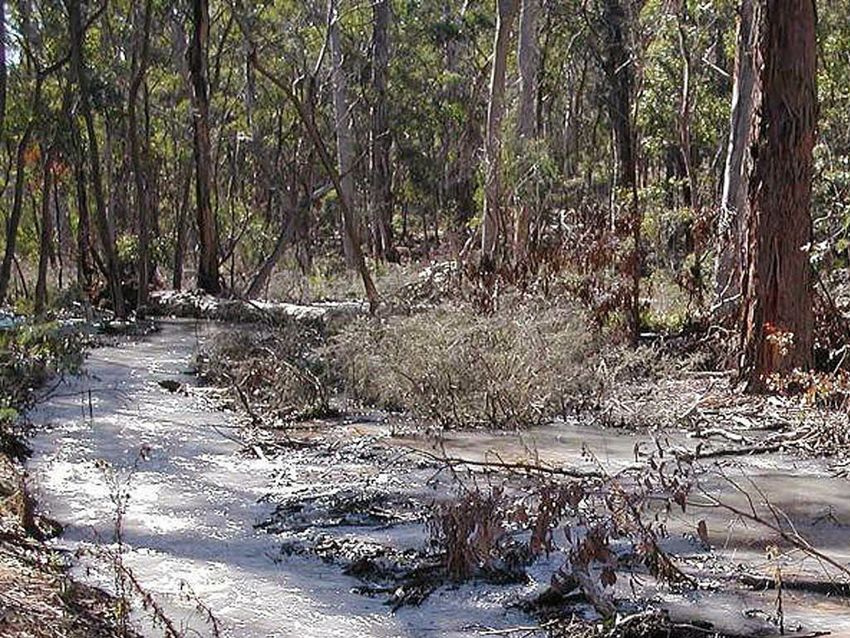
GARDENS OF STONE

ACKNOWLEDGEMENTS

T
       HIS park proposal would not have been possible without the enthusiastic support of
       the scientists and amateur naturalists who provided much of the data. I have also
       incorporated large parts of the 1985 Gardens of Stone report by David Blackwell and
Rodney Falconer of the Colo Committee into this proposal. My thanks to them.
   Karen McLaughlin prepared the maps for this report and put up with the countless
revisions that went with that task.
   David Blackwell, Keith Muir, Andrew Valja and Jaime Plaza van Roon provided
photographs. Anna Marshall drew the illustration on page ii. The illustration on page 8 was
provided by Scott Mooney, and those on pages 13 and 15 were provided by Marshall
Wilkinson. Reproduced with permission.

                                              ii
STAGE TWO

FOREWORD

T
       HE aim of this proposal is to preserve the whole of the Gardens of Stone area by
       adding the areas omitted from the Stage One declaration. The Blue Mountains parks
       have ensured the preservation of most of the outstanding scenic and recreational
assets of the Mountains but have not covered the unique qualities of the Gardens of Stone.
These include the “pagoda“ formations created by the ironstone bands within the sandstone,
and a high density of rare plants and endangered upland swamps. Despite the infertility of
its soils the area is threatened by development proposals because of its proximity to Sydney,
but it contains no commercial natural resources that are not found in abundance elsewhere.
Its real value is its scenic and biodiversity qualities, which are enhanced by its ready
accessibility.

   A. G. COLLEY O.A.M.

   Hon Secretary

   The Colong Foundation for Wilderness

                                               iii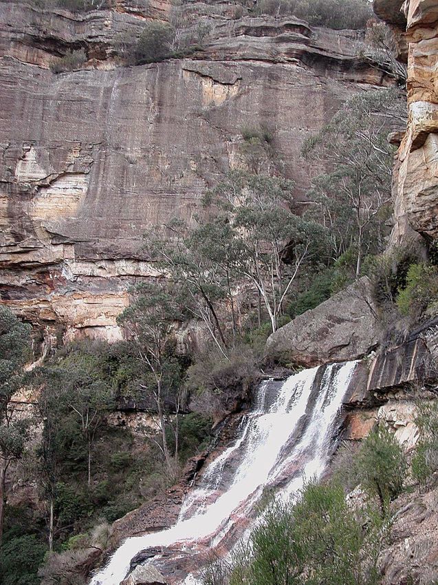
GARDENS OF STONE

 Wolgan Falls

        iv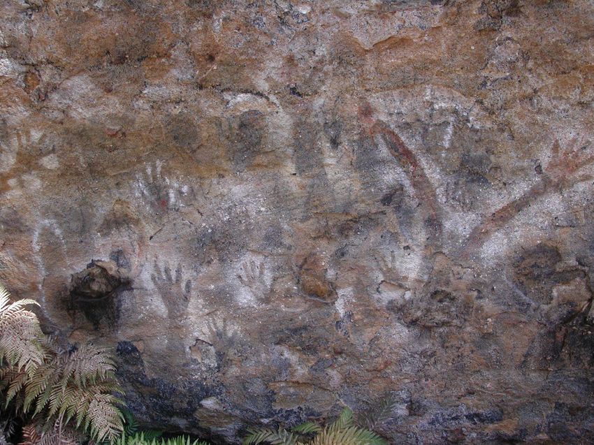
STAGE TWO

CONTENTS
Introduction                                          1

Conservation Outcomes                                 2

The Divisions of the Proposal                         7
  Genowlan Mountain                                   7
  Airly Mountain                                      7
  Wollangambee Wilderness                             7
  Newnes Plateau                                      8
  Baal Bone and Long Swamp                            9
  The Western Escarpment                              9

Heritage Values                                      13
  Geodiversity, soils and catchments                 13
  Climate                                            15
  Flora                                              15
  Fauna                                              16

  Cultural heritage                                  17
  Education and interpretation opportunities         18
  Historic railways and roads                        19
  Recreation                                         19

Management Issues                                    21
  Coal mining                                        21
  Appropriate regulation of coal mining operations   22
  Sand mining                                        25
  The Sydney Construction Materials proposal         26
  Logging operations                                 26
  Off road vehicles                                  27
  Access management necessary to protect the area    28
  Adventure recreation                               31
  Adventure recreation management principles         31
  The proposed Bells Line Super Highway              32
  Helicopter joy flights                             35
  Emirates Eco-tourism Resort                        35

Key Recommendations                                  39

References                                           40

                                               v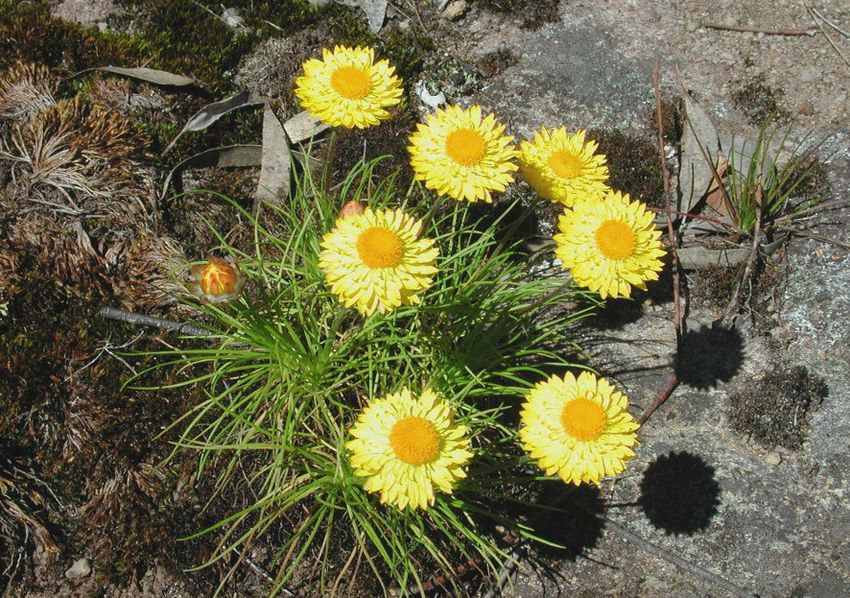
GARDENS OF STONE

Maps
  Proposed park extensions to the Gardens of Stone and
       on the Western Escarpment                              3
  Threats to Newnes Plateau and the Baal Bone area           23
  Threats to the Airly-Genowlan Mesa                         29
  Threats to the Western Escarpment                          33

                                                                  PHOTO: J. PLAZA

                              In the Grotto, Genowlan Mesa

Figures
  Sunnyside dune                                             13
  Climatic data                                              15

Illustrations
  Gooches Crater (right) Swamp                                8
  Hartley Incline                                            18

                                            vi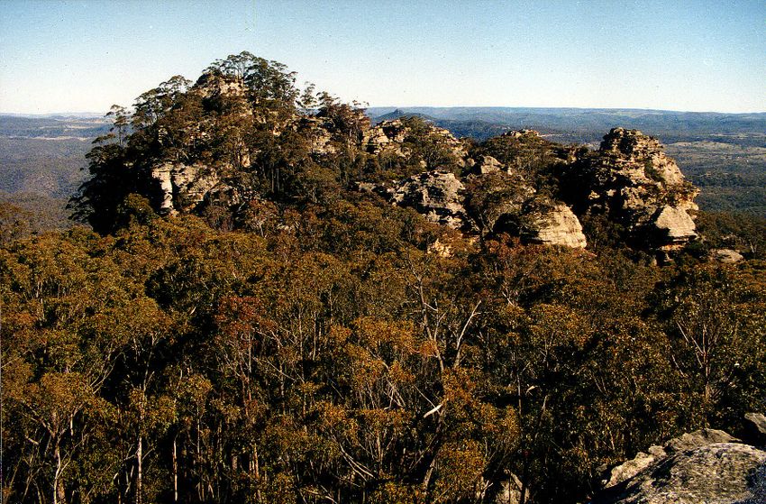
STAGE TWO
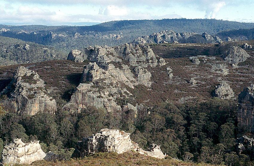
PHOTO: J. PLAZA
Waratahs near Carne Creek
vii
GARDENS OF STONE

Overhang, Airly Mesa

         viii
STAGE TWO
INTRODUCTION
T
HE Gardens of Stone, 10 km north of Lithgow, embraces the sandstone landscapes of
the Newnes Plateau, the broken stone country to the west of the Plateau and the
Airly-Genowlan mesa to the north in the Capertee Valley. The 40,000 hectare
proposal contains the last unprotected part of the 1934 Greater Blue Mountains National
Park proposal compiled by Myles Dunphy for the National Parks and Primitive Areas
Council. The proposal also includes the Blue Mountains Western Escarpment lands from
Blackheath to Lithgow.
Twenty years ago, Rodney Falconer and David Blackwell of the Colo Committee
discovered a number of rock falls from cliffs, together with cracks and fissures. The damage
was found to be associated with the Angus Place Colliery on the western edge of the Newnes
Plateau, above Lambs Creek near Wolgan Gap. Spurred on by the threat of further damage,
they had, by September 1985, completed a submission for a ‘Gardens of Stone’ 38,000
hectare addition to Wollemi National Park on behalf of the Colo Committee, the Colong
Committee and the Federation of Bushwalking Clubs.
After 10 years of campaigning and a further park proposal by the Colong Foundation,
Stage One of the Gardens of Stone National Park was created on the 29th of November
1994, covering 11,780 hectares. In December 1995 a further 3,600 hectares of the original
proposal were added to the Wollemi National Park to protect spectacular Rocky Creek and
its cathedral-like slot canyons. There have been no further additions because of the
objections to national park dedication by coal mining interests.
The unprotected parts of the Gardens of Stone now face yet another threat: surface
mining for construction sand. Sand mining is incompatible with nature conservation as the
entire landscape and its ecosystems once removed, cannot be replaced.
The Colong Foundation for Wilderness, the Blue Mountains Conservation Society and the
Colo Committee now advance Stage Two of the Gardens of Stone proposal, including all of
the remaining parts of Newnes Plateau and surrounding sandstone uplands, while accepting
the realities of current coal mining. The National Parks and Wildlife Amendment Act, 2001
provides for the reservation of State Conservation Areas that could allow coal mining as well
as the protection of areas of high conservation value. Such a reservation model may assist
with the protection of the rest of the Gardens of Stone.
Centennial Coal owns most of the mining interests within the park proposal and it usually
undertakes its operations with extensive mine subsidence protection zones that seek to
protect the natural environment. Most of the water pumped from the operating collieries is
treated before discharge, and is being directed away from national park areas. Such an
enlightened approach would be consistent with the proposed State Conservation Area.
Reservation of Stage Two, primarily as a State Conservation Area, would protect the most
spectacular pagoda landscapes in Australia. Pagoda is a local name for a large tapering and
often stepped or laminated sandstone formation. Surrounding these intricately shaped
surfaces are found large caves, mazes, ancient montane heathlands, endangered upland
swamps, snowgums, grassy woodlands and moist gullies that contain tree ferns, stands of old
growth forest and rainforest, and, in some places, slot canyons. Reservation of Stage Two
1GARDENS OF STONE
would also secure the outstanding ochre coloured cliffs of the Blue Mountains’ Western
Escarpment and the rare plant communities that lie above them.
Reservation of the remaining unprotected parts of the Gardens of Stone as a State
Conservation Area and a Western Escarpment State Conservation Area is urgently required
to rein in ongoing and accelerating environmental degradation. There has been significant
environmental damage done to Newnes Plateau and the other areas in the proposal by coal
mining, sand extraction, pine plantations, native forest logging, abuse by off road vehicles
and unregulated adventure recreation.
The existing management of public lands in State Forests and Crown Reserves has proven
to be inadequate. The outstanding diversity of the area warrants further protection and
nature-focused management.
CONSERVATION OUTCOMES
The reservation of the Gardens of Stone – Stage Two would achieve the following
important conservation outcomes:
■ Protection of the most outstanding pagoda landscapes in Australia – these include some of the
best scenery in Australia, such as dramatically coloured escarpments, narrow canyons, cave
overhangs, rock arches, lonely sandstone peninsulas and wind-formed but now well vegetated
sand dunes that are remnants of an ancient paleo-landscape;
■ Reservation of ancient windswept montane heathlands, nationally endangered upland
swamps, a unique subspecies of snowgum and other grassy high plateau woodlands, including
poorly conserved grassy white box woodlands, and moist forest gullies between these
woodlands;
■ Establishment of an unbroken continuum of forest and woodland types from the moister
coastal communities to the western slopes box country, with Newnes Plateau containing
woodlands and swamps that represent the coldest and highest development of native vegetation
on Sydney Basin sedimentary rocks;
■ Protection of the area with the highest density of rare plants anywhere in the Blue Mountains;
■ Facilitation of the interpretation and appropriate recreational use of the nationally significant first
passes to inland Australia – the Coxs, Lawsons, and Lockyers roads near Mount York;
■ Presentation of some the State’s best preserved and Heritage Listed oil shale ruins in Australia
in a spectacular setting;
■ Protection of an important scientific reference area near Gooches Crater that has yielded
important fire history data that may inform future fire management practices;
■ Better management of the most popular recreation-forest destination in the Mountains so that
the natural and cultural values of the much-loved Gardens of Stone are not degraded.
2To Mudgee
Glen Alice
Cas
N tle
re
WOLLEMI
ek
ag Cre
h
Ck
wlan
Cap
Ga p
erte
Geno
e
High
Mt Airly
Genowlan
wa y
1038 Glen
Davis
k
River
C ree
A ir l
Turo n
y
Cr
ee
k
k C NATIONAL
R ock
G
Capertee
co
Creek
re
Wol
Co
at
GARDENS gan
Pantoneys
Crown Newnes
Red
n
OF STONE Rive
Cr ow
Riv r
Ck
er ek
e
Cr
NATIONAL PARK
C oc o
Ben Bullen
Di
Deanes
Mt McLean
vid
i ng
PARK
Creek
Ck
J e ws
Baal Bone Baal Bone
Gap
Colliery GARDENS Galah Mtn Mt Cameron
OF STONE 1042 1010
ky
NATIONAL PARK
Roc
Cullen Gairdners
Bullen Gap
Ran
ek
Wolgan
C re
ge
Gap Birds Rock
Cre e k
1181
C
River
a
La
lli w
ree
m bs
k
Newnes
Wi
e
Kangaro o
Carn
Portland
Angus Place
Pipers Colliery
C o xs
Flat
Plateau
Cre
ek
Sunny
Corner
1271 Cree k
Springvale
Colliery Bun
Wallerawang gleb
oori
Lake
Creek
BLUE
Wallace
T
o
GREA ERN
aro
Clarence
WEST
ng
Colliery
rra
Ma
Wo l l a n g a m
Creek Zig Zag
be
Historical
Proposed Park Extensions Railway
MOUNTAINS
Ck
F a r me r
s River
Dargans
Lithgow Mount
to the Gardens of Stone Lake
Clarence
1172 Mount
Wilson
Lyell Hassans
and on the Western Escarpment H
Walls
IG
R i v er L e t t
Hartley
Bell Bel
ls
H Vale
Li
W
ne
Proposed extension to A
Y
of
Mount
Kerosene
Gardens of Stone National Park York NATIONAL
Ro
Hartley 1061
ad
Proposed extension to
Gr
Creek
Blue Mountains National Park
os
Cox s
e
Proposed Gardens of Stone Mount
State Conservation Area Riv
Victoria er
PARK
Proposed Western Escarpment
State Conservation Area
k
ee
State Forest Cr
ath Blackheath
khe
Pine forest Blac
National Park
River
Crown land (incl. some leasehold) Medlow Bath
Towns and villages
Highway; other sealed road
Minor unsealed road
Railway
0 Scale 20 km
Main rivers
Water bodies; other steams
October 2005 The Colong Foundation for WildernessGARDENS OF STONE
Epacris reclinata
4STAGE TWO
PHOTO: J. PLAZA
Looking towards Genowlan Point
5GARDENS OF STONE
Pagoda Daisies (Leucochrysum graminifolium)
6STAGE TWO
THE DIVISIONS OF THE PROPOSAL
Genowlan Mountain (1,680 hectares)
The Genowlan Mountain lies north of the Glen Davis Road east of the Capertee village.
It far surpasses that famous rocky Katoomba promontory, known as the Three Sisters! There
are literally hundreds of pagodas standing on this mountain – a home to 300 Sisters.
Notable rock formations of this area include the ‘Citadel’ and the ‘Valley of the Kings’, as
well as the ‘Grotto’ with its 30 metre tall Brown Barrrel eucalypt trees and four metre tall tree
ferns. A small Tertiary basalt outcrop on the plateau overlies an ancient riverbed, which adds
to this mountain’s geodiversity. Miners call the gravels that form this riverbed a ‘deep lead’,
an alluvial deposit that has in this case yielded a small number of diamonds. The deep lead
has another story to tell. It shows that this ancient land slowly evolved from a 70 million-
year-old sandstone plateau with a rapidly flowing river with a gravel bed into a lonely mesa
that stands 500 metres above the Capertee Valley today. This is a classic example of
landscape inversion.
A Planning Inquiry in February 1993 recommended Genowlan Mountain be excluded
from the proposed development consent and mining lease area for the Airly Colliery. In
recognition of its outstanding natural, cultural and scenic values the Colong Foundation, the
Blue Mountains Conservation Society and the Colo Committee again propose national park
reservation for this exceptional area.
Airly Mountain (2,020 hectares)
Airly Mountain lies to the west of Mount Genowlan and is separated from it by Airly Gap.
Ruins from oil shale mining operations are located on the slopes of Airly Gap and also on
the western side of Airly Mountain. These oil shale ruins represent some of the best of their
kind and are of state significance (Mills, R 1998). A conservation management plan to
preserve these NSW Heritage registered ruins and control visitation should be developed in
co-operation with Centennial Coal.
The northern end of Airly Mountain (1032m) contains dramatic pagoda rock formations
deemed worthy of preservation by the planning inquiry into the proposed coal mine.
Reservation in a State Conservation Area would promote best practice environmental
protection and presentation for this area.
Wollangambee Wilderness (2,380 hectares)
Situated in the south eastern part of the Newnes State Forest and north east of the
Clarence Colliery pit top, this unit of the proposal forms a broad indentation of state forest
protruding eastwards into the Blue Mountains National Park. The area is part of the identified
Wollemi Wilderness and contains several shrub swamps with rare plants. A unique spring-
fed wet sclerophyll forest of tree ferns, maidenhair fern, bracken fern, Sassafras, Peppermints
and Silvertop Ash can be found at the extreme eastern end of the state forest (Byrnes, R
2000). This division of the proposal also contains several spectacular pagoda formations.
Gooches Crater, a dramatic feature located on a northern tributary of the Wollangambe
River on the boundary of the national park, is just within the State Forest area. The crater is
7GARDENS OF STONE
not of volcanic origin but was formed when the encircling, overhanging sandstone cliffs
collapsed to block a local drainage line and form a small wetland amphitheatre. The crater
area also features a pristine upland shrub swamp, a dramatic rock arch, a slot canyon, and
large cave in a forested valley. The area is highly valued by bushwalking groups.
A deeper, more confined gully swamp adjoining Gooches Crater to the north has been
the subject of research on fire history dating back to the Holocene (14,000 bp). The
research swamp, a closed wet
heath dominated by Baeckea,
Epacris, Gleichenia, Grevillea,
Gymnoschoenus, Leptospermum,
is surrounded by Eucalypt
woodland and open heath
(Benson and Keith, 1990).
The study of charcoal deposits
in the swamp has found that fires
at the site correlate more closely
with climate change than
Aboriginal burning (Mooney , S D
& Black, M, 2004). Equally
remarkable is a finding that the
post-European period, as flagged by the appearance of pollen from exotic pine in the top 15
cm of the survey core, bears witness to charcoal accumulating at rates unprecedented in the
previous ~14,200 years. These data suggest that the area has burnt more frequently since
European occupation than previously.
Newnes Plateau (22,000 hectares)
This gently undulating plateau of 1100 metres rises to 1180 metres at Birds Rock and is
the most northerly extension of the Blue Mountains Range. The botanical diversity and vast
number of rare plants on the Plateau are related to its altitude, the intricate sandstone
landscape and location at the western-most extremity of the Blue Mountains.
The abrupt changes in soil depth are another factor related to the area’s botanical
diversity. The forests of the Plateau are found on deeper, older soils, whereas the exposed
spurs descending from the Plateau support heathlands on shallow, younger soils. The sharp
decrease in soil depth from forest to heath is most remarkable on steep slopes. Older soils
under forests suggest that forest cover, in addition to lithology and topography, may control
landform evolution.
Sandy soils and deeply weathered friable sandstone have developed in the shallow
drainage lines of Newnes Plateau to form swamp-filled valleys that are also an expression of
near-surface groundwater, relatively high rainfall, low slope and impeded runoff. The
orientation of these swamps is controlled by planar cracks that are called joints and minor
faults in the sandstone rock. This system of structures determines the drainage pattern on the
Plateau. It is in these deeply weathered sandstone areas that the quarry industry want to mine
for construction sand.
8STAGE TWO
Baal Bone and Long Swamp (7,800 hectares)
The ‘broken stone country’ of Ben Bullen and Wolgan State Forests follows the Great
Dividing Range where it dramatically sweeps to the east towards the headwaters of the Coxs
River at Gardiners Gap. The Gap is named after the notorious bushranger, horse and cattle
thief, Francis Gardiner, who operated during the 1860s. The Gap, part of the original route
to the Castlereagh Valley and Mudgee, was probably not used by Gardiner, but the myriad
of small narrow valleys that spread out from the Dividing Range in this area were absolutely
ideal for bushranging activities.
The Long Swamp, just south of Gardiners Gap, which together with the swamps on
Lambs and Kangaroo Creeks form the headwaters of the Coxs River. These alluvium filled
and often waterlogged swamps comprise closed-sedgelands of Carex gaudichaudiana and C.
fascicularis, with herbs, grasses and occasionally Sphagnum moss. In some places with more
sandy textured soils the swamps support a closed teatree heath, while the drier swamplands
carry a grassland. Upslope from these swamps are often found graceful open forests of
Ribbon Gum and Brown Barrel.
On the other side of the Great Dividing Range are the dramatic headwaters of Baal Bone
Creek whose massed pagodas are reminiscent of Cambodia’s forest temples as they may have
appeared to their European ‘discoverers’ in the 19th century. Nearby is Cape Horne which
offers dramatic views of the escarpments of the Wolgan Valley from equally dramatic pagoda
rock formations.
The Western Escarpment (4,000 hectares)
‘These walls or cliffs rise… perpendicularly above the road, and their summits, broken
and fissured in various fantastic forms, exactly resemble a ruined castle crowning the brow
of the sheer precipice, with here and there a stunted tree or graceful shrub growing from
crevices in the dark rock.’ Louisa Ann Meredith at Hassans Walls (Meridith, 1844 quoted in
Keith and Benson, 1998).
The Western Escarpment is a spectacular and dominating feature of the western Blue
Mountains, consisting of an irregular series of tall sandstone cliffs associated with steep
pagoda-capped spurs that traverse the Darling Causeway northwards and then run west
around the River Lett Valley to Lithgow. The Western Escarpment contains pagodas,
heathlands and tall escarpment forests surrounded by grassy woodlands (Eades, M,
1989).
These escarpment areas possess a very high proportion of rare plants because of the many
specialised habitats and microenvironments, such as those protected from fire, exposed to
strong winds and controlled by springs that emerge above impermeable shale outcrops. The
escarpment areas above the cliff line are highly vulnerable to degradation by development
and inappropriate fire management. The invulnerability of the escarpment is an illusion.
These areas are easily degraded by overuse.
Further south, the panoramic views from Hargreaves Lookout on Shipley Plateau are
becoming increasingly popular with tourists. The eucalypt forests below the escarpment are
part of the critical ‘bush carpet’ that form the foreground of escarpment lookouts and which
extend to the Coachwood rainforest at Blackheath Glen. This spectacular entrance to the
9GARDENS OF STONE
Megalong Valley with high sandstone walls and dense sclerophyll forest deserves better
protection.
The Western Escarpment division consists of all lands recommended for reservation in the
Blue Mountains Public Lands Rationalisation Project, Stage 1 and all other crown lands on
the Western Escarpment in the Lithgow City Council area. The proposal also includes Lot
275, DP 751650 Donald Road at Clarence, which covers 156.8 hectares of undisturbed
bushland that is currently used for passive recreation, bush walking and rock climbing. This
block is for sale as a sand resource but is better suited for escarpment preservation.
10STAGE TWO
Cape Horn, a dramatic pagoda pinnacle that
overlooks the Wolgan Valley
11GARDENS OF STONE
The high altitude grassy woodlands on Newnes Plateau are unique
12STAGE TWO
HERITAGE VALUES
Geodiversity, soils and catchments
The proposal lies on the western margin of the Sydney Basin where the western extremity
of the cliff-forming Triassic sandstones, mainly assigned to the Grose and Burralow
Formations of the Narrabeen Group, present an exposed stratigraphic column of some 800
metres. The area is the source of the Wollangambe, Wolgan and Capertee rivers, which
eventually flow east to the Colo River. Wollangambee River easily satisfies the criteria for
being listed as a wild river and the other streams flowing off the Plateau possess very
dramatic reaches containing waterfalls and rainforest-lined canyons. Other headwater
streams flow south to the Coxs River, while to the north along the Great Dividing Range,
tributaries of the Turon River flow westward.
The presence of ironstone and softer bands in the sandstones of the Gardens of Stone area
permit differential weathering that is responsible for the beehives, domes and plates in the
rock outcrops, locally called ‘pagodas’. Ferruginised sandstone shelves project up to 0.5 m
from pagoda flanks. By analogy with tors in deep weathered granite landscapes, the pagodas
may be relict cores of more resistant rock, inherited from an earlier period of deep
Fig.1 Sunnyside dune. Contours of elevation relative to an arbitrary datum.
Pagoda is a widely used local name for tower-shaped bare sandstone outscrops.
13GARDENS OF STONE
weathering of the Blue Mountain sandstones. Pagoda distribution matches that of steep,
rocky spurs above drainage lines and escarpments. A typical pagoda, 5–15 m tall, could
develop over 0.5–3 million years. Pagodas increase their relief relative to the spurs upon
which they stand at a rate of 3–14 metres every million years until they collapse via flank
retreat (~25 m/My) or spur slopes are consumed as gorges widen (Wilkinson et al., 2005).
In addition to spectacular pagodas, Newnes Plateau contains several aeolian (wind formed)
sand dunes that were active during the Last Glacial Maximum (Hesse, et al, 2003). Sand
Artwork, Blackfellows Hand Cave
stripped by wind from local soils was deposited as dunes in the lee of cliff-lines, 20–30
thousand years ago. To allow wind erosion, the Plateau must have been above the tree line due
not only to the climate being 8–9°C colder and more arid, but also because atmospheric
carbon dioxide was less abundant. The relatively large number of relict heath plant species
found on the Plateau also must have survived these very harsh conditions.
The soils of Newnes Plateau are very infertile, sandy and acid, with severe deficiencies
in plant nutrients and possessing layers of, perhaps lateritic, ironstone gravel. The soils of
valley swamps on Newnes Plateau and on the headwaters of Coxs River are organic and
highly acid. On the talus slopes below the sandstone plateau, the Permian soils are yellow-
leached gradational sandy loams.
West and north of Newnes Plateau, the Coxs and Wolgan Rivers have cut through the
sandstone to expose the softer Permian Coal Measures and the Shoalhaven Group of sediments
14STAGE TWO
below them. The Permian coal seams and
oil shale layers of the Western Coalfields,
which include the commercially-
extracted Upper Katoomba and Lower
Lithgow seams, are encountered some
200 to 400 metres below the Plateau.
Ecological communities, such as grassy
white box woodlands, are located where
the valuable coal seams outcrop and,
because these units are exploited
throughout their range, preservation of the
communities is inevitably poor.
Climate
As a temperate upland plateau, the
temperature ranges from a mean summer
maximum of 23.5ºC to a mean winter
minimum of –1ºC. Rainfall is highest on
the plateau and averages 1047mm with
a summer peak; several snowfalls can
occur each year. Rainfall decreases with
decreasing elevation and as a result of
rain shadow effects to the west reduces
to around 900 mm p.a. in the Coxs River
headwaters and north around the Airly-
Genowlan Mesa.
Topography markedly influences
microclimate: for example, cold night air
drains to gullies and hollows from the
plateau to the valleys below. Snow Gums
border these cold air drainage paths.
Strong westerly to north-westerly winds
can blow all year round and in summer
these winds can be associated with heat
wave conditions and periods of high fire
danger.
Flora
The proposal would reserve plants and communities many of which are threatened, of
limited distribution and outside the present reserve system. Reservation of the remaining
parts of the Gardens of Stone under the National Parks and Wildlife Act, 1974 would
establish an unbroken continuum of forest and woodland types from the moister coastal
communities to the western slopes box country.
15GARDENS OF STONE
Newnes Plateau is characterised by montane open forests and woodlands of Eucalypts.
The highest, more sheltered parts of Newnes Plateau are characterised by the iconic white
boles of Blue Mountains Ash (Eucalyptus oreades) in association with Eucalyptus dives and
several other eucalypt species. This woodland represents the coldest and highest
development of native vegetation on Sydney Basin sedimentary rocks. The ground cover is
either grassy or with open shrub layer.
The talus slopes and deep gullies around the Plateau are clothed with an open forest of
Grey Gum, Monkey Gum and Yellow Box, which are poorly conserved. To the west, at lower
altitudes, the Eucalypts are more typical of the western slopes. Open box woodlands extend
to the slopes of Mount Airly but these give way to ironbarks and other species of box trees
as the steeper slopes are approached.
Newnes Plateau has several botanically important upland shrub swamps that contain
distinctive, scientifically important communities of rare locally endemic shrubs, sedges and
some species of snow grass. These upland swamps extend over 650 hectares and are restricted
to the Newnes Plateau with only 160 hectares occurring in the Blue Mountains and Wollemi
National Parks (Hughes, L 2005(a)). Rare plants occurring within and adjacent to the swamps
include Dillwynia stipulifera, Olearia guercifolia, Boronia deanei, Eriostemon obovalis and a
newly discovered species of snow grass (Gymnoshoenus). Fringing these swamps are stands
of the Wolgan Snow Gum (Eucalyptus gregsoniana). All remaining temperate highland peat
swamps on sandstone are now listed as nationally endangered and should be fully protected
due to their poor conservation status and scientific importance. Preservation of such areas
intact is also necessary for continuing scientific research into past environmental changes.
Dwarf heaths, mallee Eucalypts and pagoda plant complexes define the more exposed
parts of the sandstone plateau. On the pagodas, amongst the ironstone ledges, are clusters
of paper daisies (Helipterum albicans var. graminifolium) and the gullies between the
pagodas are characterised by Banksia heaths.
The edges of the Western Escarpment, Newnes Plateau and the Airly-Genowlan Mesa
also contain many rare plants (eg. Pultenaea ‘Genolan Point’). In fact there are more than
340 native plants found on 3,000 hectares around the Airly-Genolan Mesa alone. Genowlan
Point is also home to a unique and relict plant community comprising Johnsons’s Grass Tree,
Allocasuarina nana and Micromyrtus sessilis. It is only 10 hectares in size and has survived
the withering blasts of past ice ages when sand dunes moved across Newnes Plateau.
Fauna
The distribution of vertebrate fauna across the Gardens of Stone has not been
systematically surveyed. Marsupials sparsely populate the more open woodlands and birds
and reptiles are more prevalent among the shrub heaths, along escarpments and gullies.
These latter environments, where nutrients and moisture accumulate, provide food and
shelter for amphibians in the leaf litter and shelter in the undergrowth for small mammals.
Small birds benefit from these thickets, and lyrebirds and macropods take refuge from
predators and the weather.
The escarpments and pagoda areas provide a great diversity of habitats. Even a small area
offers crevices, gullies, overhangs, massive orange cliffs and thick heath, all of which provide
16STAGE TWO
shelter. These areas support populations of Brushtailed Rock Wallabies, the Broad-headed
Snake and its preferred prey Leseuer’s Gecko, Heath Monitors, as well as populations of
Brown Antechinus, Bush Rats and the endangered Southern Brown Bandicoot. The gully
habitats provide shelter for Greater Gliders, Sugar Gliders and Ringtailed Possums.
Swamp heaths also provide shelter, water and different plants, and hence different
habitat. Swamp Rat, Southern Emu Wren and the Tawny Grassbird, as well as the Giant
Dragonfly and Leura Skink are dependent upon these habitats. The Beautiful Firetail is found
in wet and dry heaths and is at the northern end of its range.
Raptors, such as the Wedge-tailed Eagle and Kestrel are frequently sighted soaring around
the cliffs, and nests of Peregrine Falcons are sometimes found under high overhangs, such as
at Genowlan Point.
Choughs, Red-rumped Parrots, Peaceful Doves, Galahs, Crested Pigeons, Glossy Black
Cockatoos, Gang-gang Cockatoos and the Regent Honeyeaters are characteristic of the Airly-
Genolan Mesa. Also in this area are White-striped Mastiff Bats, Gould’s Wattled Bat and the
Southern Forest Bat. Five threatened bat species may forage in the area: Eastern Freetail Bat,
Eastern Falsistrelle, Fishing Bat, Large Bentwing Bat and Greater Broad-nosed Bat.
Cultural heritage
The upper Coxs River Valley has a recorded history of Aboriginal occupation probably
affiliated with the Dharug and Wiradjuri nations for the past 11,000 years. Game was more
abundant in the Capertee, Coxs and Wolgan valleys, and in the Newnes Plateau swamps that
provided continuous supplies of food and no doubt were important places given the number
of occupation sites. The archaeological deposits associated with shelters bordering some of
these swamps have some of the highest densities of artefact material recorded and are largely
unstudied. Of these, only the outstanding rock art in the 550 hectare Blackfellows Hand
Cave Reserve has been granted protection from mining operations.
The Aboriginal sites contain engravings and axe grinding grooves on flat rock surfaces,
rock shelters with substantial archaeological deposits and art, and very dense surface
deposits of artefacts often associated with the high altitude shrub swamps. Activities, such as
forestry, mining and off road vehicles can impact upon Aboriginal artefacts and sites by, for
example, increased soil disturbance and subsequent erosion.
European occupation began when James Walker established Wallerawang Station in
1824 shortly after surveyor Hoddle considered that the areas around the Coxs River and
Wallerawang were suitable for development. The occupation included an outstation in the
Wolgan Valley.
A year earlier, William Lawson discovered kerosene shale on Kerosene Creek below the
Darling Causeway at Hartley Vale. Kerosene shale was subsequently discovered at Newnes
and Capertee in 1868. Yet the development of oil shale mining has had a chequered history
and occurred in successive waves.
Oil shale mining began in the 1860’s at Kerosene Creek, with the ore being carried by
horse and cart to the railway and then by rail to Sydney for refining. Following the extension
of the railway to Lithgow, a narrow-gauge line was constructed from the main rail line on the
Darling Causeway into the valley, and the valley’s mining operations extended to several
17GARDENS OF STONE
small oil shale mine tunnels that
continued operation until the First
World War. The railway easement
from the Darling Causeway to near
the top of the incline exists today as
a track. Remains of the incline are
easily found, along with brick and
sandstone ruins of the winding
house and other relics. In the valley
below are two historic inns and the
remains of the mining village
settlement.
The oil shale deposits of the
Airly-Genowlan area were first Three oil tankers at Hartley Vale incline, 1906
reported in 1883 and later
developed in 1893 for export by individual miners. The Australian Kerosene Oil and Mineral
Company began working the resource in 1895 followed by the Hartley Vale Company.
Development of this resource was in response to the decline of resources in the Katoomba,
Hartley and Joadja areas. In 1903 mining operations in the Airly-Genowlan area entered a
period of instability until 1913 when production ceased owing to competition from mines at
Newnes. During this period extensive infrastructure was constructed including a rail siding
and 20 retorts on the western side of Mount Airly.
The ‘ghost town’ near Airly Gap is an outstanding cultural heritage site, with remnants of
tunnels, cableways, oil shale retorts, steam engines, dwellings, transportation and mine
ventilation chimneys. These ruins have been placed on the NSW State Heritage List. Set
amongst cliffs and valleys, which greatly enhance their scenic attraction, the oil shale ruins
comprise an outstanding heritage site.
Education and interpretation opportunities
Newnes Plateau is a living laboratory for the study of natural science, cultural heritage
and the changes in land management as practiced though time. Weathering and erosion, for
example, have their expression in the exposed strata of the Sydney Basin and this is
intimately linked with the distribution of native vegetation and animals.
The area lends itself to day and weekend excursions, which could be integrated with existing
tourist infrastructure such the Zig Zag Railway, the State Mine, and other cultural heritage sites,
including the evocative oil shale mines on the eastern outskirts of Lithgow. The Gardens of Stone
and Lithgow’s very own Western Escarpment should gain further protection and recognition
before these precious natural and cultural assets are further degraded by neglect.
The rock art at Blackfellows Hand Cave, the most readily accessible reminder of
Aboriginal activity in the Newnes area, is located just off the Wolgan Road near Wolgan
Gap. Its precious art is being degraded by graffiti, instead of being honoured as a vital
connection with the past.
18STAGE TWO
Historic railways and roads
At the time of building in 1866-69, the railway viaducts on the Western Escarpment near
Lithgow, and known as the Zig Zag, were regarded worldwide as an engineering marvel. The
three main viaducts are significant technical accomplishments, particularly given the
difficulty of the escarpment site. The area was declared a 220 hectare public reserve in 1881.
The reserve is a fine scenic attraction in itself, with superb views.
Nearby, the Commonwealth Oil Corporation in 1906-07 built the Wolgan Valley Railway
to serve both people and the refinery at Newnes. This private railway was another remarkable
feat of civil engineering, albeit one of a different order. It was built in only twelve months
over difficult terrain. Extending 51 kilometres from Newnes Junction to Newnes, the line has
two unlined tunnels, the largest now well known as the Glowworm Tunnel. The total drop in
elevation on the line was 700 metres and necessitated the use of geared locomotives with
vertical pistons and crankshafts (shay locomotives). The line closed with the Shale Oil
Refinery in 1933 but remains as a link to a time, not so long ago, when oil was far more
precious than today, and not so easily won from the ground.
The Western Escarpment proposal contains further transport links with the past. Between
1815 and 1830 three roads were constructed from the Western Escarpment into Hartley Vale
(Cronin, L, 2005). These roads are now walking tracks linking the Mount York peninsula with
the Hartley Valley. Coxs Road, the first and original pass to the west, was constructed in only
five weeks in 1814 and is extremely steep. To provide a road with better grades, Lawsons
Long Alley was constructed between 1823 and 1824. Work on the last road, Lockyers Road,
commenced in 1828 and, despite never being completed because the workers were diverted
to the construction of Victoria Pass, today it provides walking access.
Recreation
The recreation potential of this area ranges from family outings, picnicking, car camping,
day walks to multi-day bushwalks, rock climbing, abseiling, examination of industrial ruins,
nature study, bird watching and photography. Unfortunately much of this potential is being
spoilt by a predominance of inappropriate off-road vehicle activity that tends to drive away
the broader community from enjoying this wonderful area.
The proposed Gardens of Stone State Conservation Area has the potential to be enjoyed
by many visitors and could take the increasing stress away from the existing facilities in the
Central Blue Mountains. There are scenic treasures such as grand vistas and massed pagoda
rock formations. Passive recreation opportunities abound in the extensive areas of grassy
open woodland. There are nationally significant cultural and industrial heritage sites nestled
in some of the most scenic valleys and escarpments of NSW. A management plan to protect,
manage and interpret these values is essential to facilitate appropriate use of the area.
19GARDENS OF STONE
Ruins of ‘The Bakery’ in the oil shale miner’s village, Mount Airly
20STAGE TWO
MANAGEMENT ISSUES
O
FF road vehicle activities, logging, sand quarrying and coal mining are making ever-
increasing incursions into the Gardens of Stone. All these activities cause serious
environmental damage to fragile rock formations, streams, cliffs and groundwater-
dependent ecosystems such as upland swamps. The following section describes the impacts
and presents a comprehensive environment protection plan to curb the cumulative impacts,
prevent damage and foster appropriate recreation within the proposal area.
Coal mining
The Katoomba and Lithgow Coal Seams under the State Conservation Area proposal have
been subject to underground mining for more than 120 years. An advantage of underground
mining is that the associated surface works, such as ventilation fans, can be located away
from the more environmentally sensitive areas. In practice, however, the location of dams,
pumping stations, powerlines, water pipes and numerous roads within the proposal area
have tended to be hastily considered with little thought given to minimising the cumulative
impacts of successive infrastructure installations. Some recent efforts have been made by
Centennial Coal to locate new infrastructure within existing road easements which has partly
reduced the impacts. Unfortunately these efforts to protect the environment have in part
been negated by the construction of an effluent diversion pipeline through an endangered
Newnes Plateau Shrub Swamp.
The problems associated with coal mining include:
1. Mine access roads and utility easements that fragment bushland, encourage
inappropriate off road vehicle use and facilitate weed infestation and foraging by feral
animals.
2. Soil erosion associated with mine operations and road construction, and soil slumping
associated with subsidence of the land surface when the coal seam is extracted. Mine
subsidence occurs when the rock strata above the colliery collapse into the void created
when the coal is removed. In the Newnes Plateau area, surface subsidence can be up to two
metres, but is typically in the order of one metre.
3. Cliff collapse: surface subsidence can be associated with rock fracturing, which, when
it occurs near cliff lines, induces cliff collapse and rock falls. Cracks can also transgress
prominent physiographic features, such as pagodas, woodlands, heath and swamps. Such
damage is capable of degrading the visual quality and ecological function of the landscape.
4. Changes to the watertable, particularly but not solely in the context of endangered
upland swamps and natural springs, can cause dieback of native vegetation and subsequent
loss of wildlife. The swamps can dry out and sustain serious gully erosion and be destroyed
entirely if the peaty soil burns during the next bushfire event. Establishing protection zones
in key areas, including all streams and the high altitude shrub-swamps of Newnes Plateau,
will reduce damage to the groundwater table. This is particularly important as these peat
swamps make a fundamental contribution to the Wolgan River and its tributaries, sustaining
the river during dry periods.
21GARDENS OF STONE
Under the Threatened Species Act, 1995 the NSW Scientific Committee has listed
longwall mining as a Key Threatening Process to threatened species and communities
(Hughes, L. 2005(a)). Such mining has contributed to adverse effects on the Newnes Plateau
upland swamps, which have been recently listed as Endangered Ecological Communities
(Hughes, L 2005(b)). The adverse effects of longwall mining are best documented for swamps
on the Woronora Plateau (Gibbens, 2003), that are functionally similar to those on Newnes
Plateau and likely to be affected by the same adverse influences.
5. Dissolved and filterable salts of manganese and iron are present in waters pumped
from the collieries within the park proposal. Oxidation of the effluent water by biological
agents causes anoxic conditions for some distance downstream from the discharge points.
Pollution of pristine streams, such as the Wolgan and Wollongambe Rivers and Bungleboori
Creek is abhorrent and should be totally avoided. Mining operations currently extract about
28 ML of water per day from the groundwater resources of Newnes Plateau. This effluent
water is now being diverted by Centennial Coal into the Coxs River catchment for storage in
Lake Lyell and Lake Wallace. There is concern that this level of pumping will, over the
protracted life of mining operations, compromise streams running from Newnes Plateau into
Sydney’s water supply catchment and the World Heritage Area, perhaps even to the extent
that they cease flowing except after heavy rain. Should this eventuate, wholly or in part,
many Newnes Plateau Shrub Swamps will die. It is unfortunate that this valuable
groundwater resource is to be wasted as coolant in the coal fired Mt Piper and Wallerawang
power stations. The State Government has yet to apply more stringent water conservation
measures to the power industry.
Appropriate regulation of coal mining operations
By having regard to conservation of the area’s natural and cultural values, coal mining
operations can minimise their impacts on the proposed State Conservation Area. Despite
nearly all the proposed State Conservation Area being subject to coal mining leases or
interests, it is possible to reserve it to a depth restriction under section 30G of the National
Parks and Wildlife Act 1974. Section 47H of the same Act provides that a state
conservation area does not affect “the terms and conditions of any existing interest in
respect from those lands from the Crown… or the use permitted of those lands under the
interest”.
The recently-introduced coalmine subsidence management planning process should
ensure that the values of the Gardens of Stone area are protected for future generations.
Under subsidence management plans upland swamps, pagodas and cliff lines all qualify
for protection from mine subsidence. Protection zones require parts of the coal seam to be
retained to ensure that the surface environment does not experience environmentally
unacceptable subsidence during mining operations.
Using the subsidence management planning process, protection zones should be
extended to apply to streams within coal leases to ensure that aquatic environments and their
dependent wildlife are not destroyed.
Areas requiring priority protection include Cape Horne to Mount McLean, an extremely
scenic but remote watershed running off the Great Dividing Range, and the Baal Bone Creek
22To Mudgee
k
Gr
THREATS GARDENS OF STONE
e
ee
Cr
at
Potential sand resource
NATIONAL
PARK
Sand mine
Ben Bullen
Proposed sand mine Mt McLean
Glow Worm
Tunnel
D ean es
D
Coal mine WOLLEMI
Creek
ivi
di
Pipeline from coal mine Baal Bone
R.
ng
Gap
Ck
J e ws Wolgan
Pumping station: existing, proposed
Baal Bone
Colliery
Water pollution from coal mine
Galah Mtn Mt Cameron
Trail bike and 4WD impacts GARDENS 1042 1010
y
Proposed resort development
OF STONE
Rock
NATIONAL
Hardwood logging Cullen Gairdners
Gap NATIONAL
Bullen PARK
Bicentennial National Trail
Ran
Proposed helicoptor joy flight routes Wolg
ge
Wolgan an
Proposed 'Super Highway' Gap
Long Swamp Birds Rock
Riv
1181
er
PROPOSALS PARK
C re e k
L a m bs Creek
Proposed Gardens of Stone e
State Conservation Area
Kangaro o
Carn
Proposed new locked gate
er
Angus Place NPWS Identified Wollemi
Riv
Colliery Wilderness Boundary 1997
EXISTING LAND USE
National Park Pipers
Flat
State Forest
C re e
Newnes
k
C o xs
Plateau BLUE
Pine forest
Lidsdale
Crown land (incl. some leasehold) k
N Cre e
OTHER FEATURES Bunglebo o r i
Sprin gvale
Existing locked gate Colliery MOUNTAINS
Wallerawang
g
Towns and villages
Lake
Highway; other sealed road Wallace
Scale Creek
Minor unsealed road A T
0 2 4kms GRE
Railway Marrangaroo
o NATIONAL
WES
roo
Main river Note: Some data on this map is diagrammatic
TER
ga
N
To Bathurst
an
Water bodies; other steams
ar r
Clarence
M
Colliery Wo l l a n g a m b
k e PARK
THREATS TO Cree
Zig Zag
H
Historical
W
Railway
Y
THE NEWNES PLATEAU Be
ll s
e rs Lin
eo
October 2005 F arm River
fR
Lithgow
Dargans Ck
The Colong Foundation for Wilderness
oa dGARDENS OF STONE
The cliff falls above Lambs Creek were due to coal mining in the 1980s
A Springvale Colliery discharge flows into the World Heritage Area
24STAGE TWO
headwaters, both in Wolgan State Forest. Similarly, the outstanding scenic beauty of the cliffs
and pagodas, and the important cultural heritage of the oil shale ruins should make Mt Airly
a heavily constrained area for mining, with extensive protection zones. The best mining
method for the Airly Mountain would be partial extraction by bord and pillar methods, as
adopted at the Clarence Colliery. This mining method has protected Gooches Crater from
damage by limiting surface movement to three centimetres.
Pollution licencing by the Environment Protection Authority and selection of the
appropriate discharge points can prevent damage to pristine rivers. Clarence Colliery has
established an upgraded water treatment plant for mine water so that iron and manganese
are removed before discharge. Recently these discharges have been directed to Farmers
Creek and should be used to improve environmental flows for the upper Coxs River rather
than to enhance water supplies for power generation. The water from the Springvale Colliery
is also being transferred from the mine pit to the Coxs River catchment but without adequate
treatment. The in-ground placement of the waste water transfer pipe from the Springvale
mine should minimise visual and wildlife impacts; however, pipeline construction has
damaged sensitive upland swamps and woodland communities.
Sand mining
A draft sand mining strategy developed by the Department of Infrastructure, Planning and
Natural Resources in June 2005 plans to provide Sydney with sand resources for the next 30
years and has targeted Newnes Plateau for investigation. The Department has identified a
several billion tonne sand resource on the Plateau that it wants to assess. Sand quarrying in
indifferent surroundings is not objectionable but large-scale surface mining would be
intolerable on Newnes Plateau, particularly as the industry has difficulty keeping to
established environmental safeguards, such as ensuring its discharge waters are clean of
sediment.
Sand mining requires the complete removal of the natural environment due to clearing
and wholesale quarrying of the landscape. Road works, soil erosion, steam siltation and
vehicle pollution extend this destruction beyond the immediate extraction site. Three
operations have consent to quarry sand on Newnes Plateau: Boral Resources, Kables Sands
(Pioneer Concrete) and ROCLA Quarries. Of these, ROCLA has virtually exhausted its lease
area, Kables Sands has just received a 20 metre depth extension for its existing site and Boral
Resources is not operational. Approximately 310,000 tonnes of sand per year are currently
being quarried from the ROCLA and Kables operations.
The environmental impacts of surface mining for sand on Newnes Plateau include:
■ Visual impact on scenic amenity of the plateau and surrounding valleys;
■ Dust and noise pollution from quarrying and truck movements;
■ Discharge of turbid water from overflow points and filling of downstream water holes
and canyons with sediment;
■ Replacement of hillsides with supposedly rehabilitated deep rectangular pits
(unsuitable for any future use);
■ Failure to sequentially rehabilitate mined areas during quarry operations resulting in
ongoing pollution and environmental degradation;
25GARDENS OF STONE
■ Disturbance to the hydrology of the watertable, thereby inducing ecological
destruction;
■ Lowering of the near surface watertable causing the unique high altitude shrub swamps
to dry out and be replaced by exotic pines and other trees.
Many sites around Sydney contain sand resources, and of these the Newnes Plateau on
the watershed between the Greater Blue Mountains World Heritage Area and the headwaters
of Sydney’s water supply catchment would be one of the least suitable places for
development of a sand mining district. If the mining strategy is approved a visually intrusive,
polluting, noisy, dusty blight will be imposed on one of the most botanically diverse areas
around Sydney.
Local and state environment groups oppose surface mining within this park proposal due
to the significant and non-reversible damage caused. In particular, the groups oppose the
proposal by Sydney Construction Materials for a 27 million tonne mine adjoining the World
Heritage Area at Newnes Junction and the proposed sand mining site in bushland on the
Western Escarpment south-east of Clarence Village.
The Sydney Construction Materials proposal
Sydney Construction Materials’ sand and clay mining proposal is in a Crown Reserve on
a descending spur that leads to the Wollangambe River and the Wollemi Wilderness; it is
sandwiched between a small village at Newnes Junction and the Blue Mountains National
Park. To prevent intrusive development locating next to the World Heritage Area, the site
should be added to the proposed state conservation area.
A previous sand and clay quarry proposal on the site was rejected by the Lands
Department as being at odds with the preferred nature conservation and environment
protection uses of the Village Reserve. The diverse bushland on the site is essentially in a
pristine condition and includes two nationally endangered shrub swamps. This proposal,
located close to the Wollangambe River, would have more direct impact upon the park and
be more visible than any existing operation in this sensitive catchment upstream of the
Wollemi Wilderness.
Logging operations
To identify Ben Bullen, Wolgan and Newnes Plateau ‘State Forests’, as viable timber
production areas is a stretch of the imagination. These logging reserves encompass large
areas of open woodland with extensive heath lands, swamps, bare rock, cliff and steep rocky
slopes. Logging operations are associated with the isolated pockets of iconic Blue Mountains
Ash (Eucalyptus oreades), which is used for pit props for which there is a declining demand.
The radiata pine plantation in the centre of Newnes Plateau requires tremendous inputs of
nutrients and a large fire break to maintain the investment. Without huge fertilizer inputs the
plantation would not be viable. To provide the needed nutrients, sewage sludge has been
spread over the plantation at a rate of 30 tonnes a hectare, which causes significant pollution
of the adjoining Newnes Plateau Shrub Swamps and downstream pristine environments
within the World Heritage Area. The pine forest sits over an Aeolian dunefield of deep,
26STAGE TWO
permeable, acidic sand and is the last place to dump sewage sludge. Bushwalkers, canyoners,
the local community and conservationists were successful in their campaign to have this
practice stopped believing it would compromise pristine waters running off the Plateau.
Further damage to the integrity of the Plateau will occur if the pine plantation is further
expanded or if mechanical harvesting of Blue Mountains Ash is initiated. Continued
retention of these unproductive state forests is difficult to justify on ecological and economic
grounds.
To stop the economic and environmental losses, the pine plantation should be
clearfelled, ripped and the affected areas allowed to recover by fostering native regeneration
from existing seed stock within the soil and adjoining areas as well as some revegetating with
native plants of local provenance if this proves necessary. This approach to rehabilitation has
been successful in the former Jounama Plantation in Kosciuszko National Park.
Off road vehicles
The Gardens of Stone State Conservation Area proposal should encourage the responsible
use of vehicles by family groups, rather than promote use by high impact off road motor
sports enthusiasts. The potential adverse impacts of recreational off road vehicles on natural
environments include:
■ vegetation damage and removal
■ damage to rock formations
■ soil compaction
■ erosion
■ rutting and gullying of 4WD management roads
■ stream bank erosion
■ stream siltation
■ noise as many trail bike motors do not have adequate mufflers
■ increased fire risks associated with use of trails
■ blazing of new tracks
■ costly repairs to management tracks
■ increase in illegal activities (collection of plants, firewood, animals and rock)
■ dust generation
■ damage to and fragmentation of sensitive environments
■ death and displacement of native animals
■ dumping of travellers wastes, rubbish dumping and other mindless vandalism, such as
using trees as vehicle winch anchor points, ringbarking and killing them
■ weed dispersal
■ incompatibility with other users seeking quiet recreation
■ endangering the lives of themselves and other park visitors
■ damage to cultural heritage sites (Aboriginal sites and historic road passes)
■ loss of native vegetation and scarring of the landscape
Road development is one of the key environmental impacts arising from coal exploration
and mining, largely a result of constructing access lines for exploration and monitoring
27GARDENS OF STONE
processes, followed by the provision of powerlines and surface infrastructure for mining and
water transfer processes. The establishment of these rough 4WD exploration and utility
access roads enables trail bike riders, rubbish and car dumpers, bush rock thieves, pig dog
hunting enthusiasts and shooters to access otherwise remote bushland. The problem is
multiplied by logging roads, numerous minor tracks used to pull a handful of logs out of the
surrounding rugged bushland and by fire management roads. The latter roads are
unnecessary, given the other roads in the area.
Drivers and riders of a proportion of off road vehicles, particularly trail bikes, revel in the
so-called ‘technical terrain’ with mud, sand, ‘roll overs’, steep slopes, loose rocks, stream
crossings and rock bars. In the last decade, off-road activity has begun to cause
environmental degradation over a wide area of the Gardens of Stone.
While there are some 4WD clubs and associations that promote responsible driving
amongst their members – being the drivers of registered vehicles by licensed drivers on
designated 4WD trails – there is clearly a significant majority using the Gardens of Stone
area who drive vehicles irresponsibly, may be unlicensed and/or drive unregistered
vehicles. Unlicensed trail bike riders often have no regard for the damage they cause or the
fact that their off road activities are illegal. There is currently very little management of these
activities.
Damage to the geodiversity of the Gardens of Stone is permanent; some flora may
eventually recover but not the non-living part of the ecosystem.
Access management necessary to protect the area
A much more precautionary approach is required for vehicle access regulation in the
Gardens of Stone. To be sustainable, visitor use and enjoyment must be made compatible
with the conservation objectives of the proposed conservation area. No motor vehicle should
be allowed to go off road on public lands, particularly in a sensitive area like Newnes
Plateau.
Bungleboori camping and rest area is located at the junction of the old Bells Line of Road
and the Glow Worm Tunnel Road. Trail bike riders have spoilt the area but it has recently
been rebuilt. The water tank has been smashed at least once and the area from Bungleboori
to the Fifteen Mile plantation has become their exclusive playground riddled with eroding
tracks. Police patrols should be increased to prevent trail bike riders driving illegally or
irresponsibly.
The siting of park facilities should be away from fragile rock environments. Competitive
events are not acceptable in the pagoda landscapes due to potential injury to competitors
and the likelihood of damage caused by competitors stumbling over padogas.
Appropriate signage should regulate vehicle use of retained management tracks, while all
unwanted tracks should be closed, actively rehabilitated and management trails gated.
The gated access on the Wolgan River link road is a step in the right direction. The plan
of management for this sensitive area should limit access to pedestrians only. This short road
should be closed and rehabilitated. The Wolgan River crossing serves no purpose other than
to present a challenging river crossing and hill climb for 4WD vehicles. Similarly, vehicles
should be prevented from driving onto the rock formations at Cape Horn.
28You can also read