City Centre Area Action Plan - Bradford District Local Plan Baseline Report (Draft) - Bradford Council
←
→
Page content transcription
If your browser does not render page correctly, please read the page content below
Bradford District Local Plan

City Centre Area
Action Plan
Baseline Report (Draft)

                               1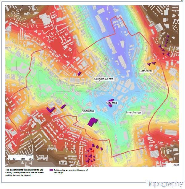
Contents

1.0 Introduction                                                      03
       1.1 An Overview of Bradford City Centre                        03
       1.2 Bradford City Centre Area Action Plan                      05
       1.3 Purpose of the Baseline Report                             05
       1.4 Structure of the Baseline Report                           06

2.0 Setting the Context: City Centre Regeneration                     07
      2.1 The Big Plan- Sustainable Community Strategy for Bradford   07
      2.2 Bradford City Centre Masterplan and NDFs                    08
      2.3 Bradford City Centre Design Guide                           10
      2.4 Bradford Learning Quarter Design and Delivery Framework     11
      2.5 The City Plan                                               12
      2.6 City Centre Growth Zone                                     13
      2.7 Super Connected Cities Programme                            15

     Bradford City Centre Baseline Information

3.0 Built Form and Character                                          16
      3.1 City Centre Townscape                                       16
      3.2 Key Landuse Character Areas                                 17
      3.3 Built Heritage                                              19

4.0 Social and Demographic Information                                21
       4.1 Population                                                 21
       4.2 Housing                                                    22
       4.3 Education and Health Facilities                            23
       4.4 Other Community Facilities                                 24
       4.5 Transport and Movement                                     25

5.0 Environmental Information                                         28
       5.1 Air Quality                                                29
       5.2 Flood Risk                                                 33
       5.3 Biodiversity and Wildlife                                  34
       5.4 Open Spaces                                                35
       5.5 Archaeology                                                36

6.0 Economic Information                                              36
       6.1 Office Market Profile                                      37
       6.2 Residential Market Profile                                 38
       6.3 Retail Profile                                             39
       6.4 Leisure and Tourism Market Profile                         40

7.0 Conclusion                                                        44
     Appendix: List of documents reviewed                             45

                                                                       2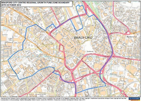
1.0 Introduction

This report sets out the baseline position for the Bradford City Centre, including the key
issues and parameters which will inform the preparation of the Bradford City Centre Area
Action Plan (BCCAAP).

The BCCAAP will provide the long term framework for development and change in Bradford
City Centre. It will co-ordinate development interests and will include proposals for the
development of sites for shopping, commercial, leisure, education, community use, strategic
employment, mixed-use housing areas, transport initiatives and environmental protection.

It is important that the policies and proposals of the BCCAAP are based on an up-to-date,
robust and reliable evidence base to ensure a thorough understanding of the needs,
opportunities and any constraints of the area.

The Council has drawn on a range of information about the important aspects of Bradford
City Centre including housing, the local economy, environment, transportation and
community facilities to form the evidence base for the AAP. These pieces of work provide a
picture of the Bradford City Centre in terms of key issues and also their spatial relevance.

1.2 An Overview of Bradford City Centre

Bradford City Centre is at the heart of a district of around 467,665 people (Source: Census
2001). It started life in Saxon times as a small settlement, then known as ‘Broad Ford’, which
was based around Ivegate, Kirkgate and Westgate, the medieval street pattern of which still
remains.

The city centre is set in a natural bowl which marks the confluence of a number of streams,
including Bradford Beck. As a result the city centre is characterised on all sides by the steep
hills which surround it.

This ‘bowl’ was formed in the ice age, and was rich in natural resources such as soft water,
sandstone, iron ore and coal. The exploitation of these natural resources helped to fuel the
rapid expansion of Bradford during the Industrial Revolution when it became the Wool
Capital of the World. During this period, thousands of people migrated here, including many
from Ireland, to work in the woollen mills. The city boomed and the population swelled from
13,000 to 280,000 during the 19th Century.

In order to accommodate this growth the streams were culverted and built over. A new canal
link was constructed, later followed a railway for moving goods and materials between the
city centre and the wider region. The railway still remains today but the Canal, became
redundant and heavily polluted, and was drained in 1867.

The rapid industrialisation of the city caused problems such as squalor and environmental
degradation. However many of the buildings from this era reflect the prosperity and

                                                                                             3
confidence in the city at the time. Much of this built heritage still remains today including City
Hall, the Wool Exchange and the merchant’s quarter of Little Germany.
By the 20th Century the woollen trade in Bradford had started to decline resulting in a long,
drawn out period of decline. However people still continued to migrate here, this time from
further a field, from Italy and Eastern Europe, and from Commonwealth countries in the
Caribbean and Indian sub-continent.
Large parts of the city centre were rebuilt during 1960’s, and some of the architectural
heritage was swept away and replaced by buildings which on the whole have not worn well.
This, together with big new road schemes, has created a fragmented city centre, which does
not fit together well and is awkward for pedestrians to move around.
At the start of the 21st Century the city centre was experiencing a difficult period, and
struggling to find a new role for itself.
Apart from the National Media Museum and the Alhambra Theatre there was little to attract
people to the city centre in terms of its shopping and leisure offer. Also, as an industrial city,
it has never had a strong office sector, or a tradition of people living a fashionable urban
lifestyle in the city centre. The riots of 2001 were a further setback but since this time there
has been an upturn in fortunes as Bradford tries to reinvent itself and reclaim its position as
one of the UK’s leading regional cities.
This is now an exciting time for Bradford. In 2003 an Urban Regeneration Company was set
up and a Masterplan produced to facilitate the renaissance of the city centre. Market
confidence has returned to the centre, particularly with regard to residential development,
whilst the new Broadway development will vastly improve the shopping offer in the city
centre. Once again Bradford is seeing an influx of migrants into the city, this time from all
over the world, including Europe, Africa, and Asia.
Here are some current statistics relating to the city centre. There are:
3,744 people living in the city centre.
2,000 businesses employing 42,800 people in the city centre.
305,000m2 of office floorspace and 527,000m2 of industrial floorspace.
501 shops totalling 110,000m2, of which 129 units are vacant.
1.2 million visitors per year to the top 5 tourist attractions, including the Alhambra and
National Media Museum.
9,822 people studying at the University.
10,600 people travelling into the centre daily by train, and 19,200 by bus.
10 public open spaces.
100 (approx) Listed Buildings.
*These statistics are based on the Bradford Centre Regeneration Boundary using data
correct up to March 2005 (Source BCR Performance Framework, Genecon, 2006).
4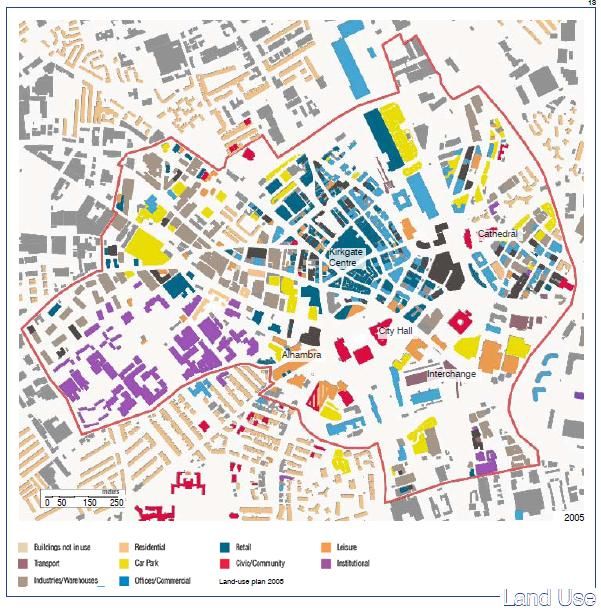
1.2 Bradford City Centre Area Action Plan (BCCAAP)
The Bradford City Centre Area Action Plan will set out planning policies to guide
development proposals in the city centre, along with details of how these proposals will be
delivered, looking as far ahead as 2028. It will also be used to make decisions when people
apply for planning permission in the city centre.
The City Centre Area Action Plan will seek to identify future issues and specify policies and
allocations in order to:-
Deliver proposed growth of the city centre
Stimulate Regeneration
Protect built heritage whilst accommodating new development
Ensure developments are of appropriate scale, mix and quality
Bradford District is made of 5 Parliamentary Constituency areas – Bradford North, Bradford
South, Bradford West, Keighley, Shipley. The Bradford District is composed of 30 Electoral
Wards. Bradford City Centre is within Bradford West Parliamentary Constituency and the City
Ward.
The study area boundary line
starting from the west runs along
Shearbridge Road, Listerhills
Road, Norcroft Street across to
Jowett Street, down Westgate
then across to Drewton Road,
along Hamm Strasse, up Valley
Road around Bradford Business
Park, down along Canal Road the
across to Shipley Airedale Road
to Wakefield Road and then
across Caledonia Street, then up
along Manchester Road, Senior
Way across to Great Horton Road Fig 01: Bradford City Centre
to the junction with Shearbridge Road.
1.5 Purpose of the Baseline Report
It is critical that the City Centre Area Action Plan is based upon a robust evidence base. This
report describes the core baseline conditions and context that will inform these documents.
This baseline report has been prepared on the basis of a desk top study and analysis of
published information and strategies, discussion with key stakeholders, bespoke research
and site survey.
In accordance with good practice advice by the Planning Advisory Service, including the
online Plan Making Manual, Bradford Council considers the gathering of evidence as an
5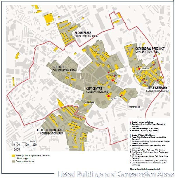
iterative process which must be continued throughout the plan preparation process. The
reason for this is because the evidence base is key to other aspects of plan production
including, Sustainability Appraisal, Options Generation and Community Engagement. The
diagram below explains the linkages between these different areas (Source: PAS March
2008).

                Fig 02: Relationship between different elements of plan production

This report therefore has been deliberately left in ‘Draft’ and will be supplemented with
additional information during the course of the preparation of the Area Action Plan. As part of
the ongoing consultation process, this report is made publicly available for statutory
consultees and other stakeholders for comments and review.

In preparing this report, we have not sought to replicate all published and unpublished
documents and data, but to identify and describe key issues and findings that are raised. In
considering the overall ‘Evidence Base’ that informs the emerging Area Action Plan
reference should be made to the individual documents, strategies and data sources that are
identified in each chapter.

A list of all the documents reviewed as a part of this baseline analysis is attached as
appendix 1.

1.6 Structure of the Baseline Report

This report seeks to identify and review the key baseline information thematically under four
broad headings, as follows:

                                                                                             6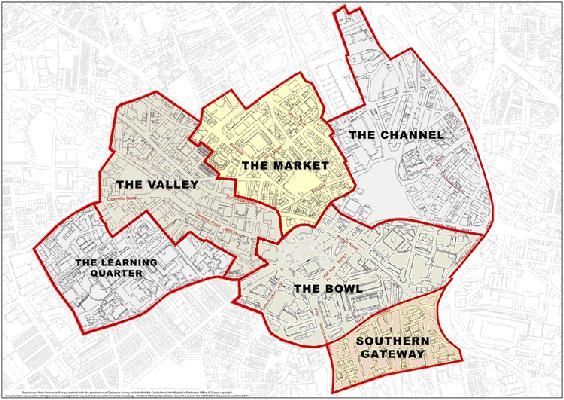
Setting the City Centre Regeneration Context – This section identifies and reviews a
range of current and emerging plans, strategies and regeneration initiatives that
would affect future developments in the city centre.
Built Form and Character- This section provides an assessment of the physical form
and structure of the city centre including an analysis of the cityscape and
assessment of the historic buildings, streets and spaces.
Social and Demographic Information– This part of the report contains an appraisal of
the demographic and social context of Bradford city centre. This includes brief
reviews on city centre population, housing, community facilities, transport and
movement.
Environmental Information- This section provides an overview of the environmental
and historic elements within the city centre including air quality, flood risk, built
heritage and biodiversity.
Economic Information- This section analyses the current and potential commercial
and business activities within the city centre which includes detail assessments of the
office, retail, residential and leisure market profile of the city centre.
2.0 Setting the Context: City Centre Regeneration
Bradford City Centre is the main focus for economic, educational, administrative and cultural
activity within the district. With 1 in 5 jobs in Bradford district located in this area the city
centre offers real potential as an engine for growth and regeneration. It is therefore important
to understand the various regeneration plans and strategies that have been prepared to
influence development in the City Centre. It is also crucial to reflect the findings and
recommendations of those studies to ensure that any future plan for the city centre does not
occur in a vacuum and creates a synergy that can be more powerful to deliver sustainable
changes in the area.
Some of the key plans and strategies that have been reviewed as a part of this baseline
study are:
2.1 The Big Plan- Sustainable Community Strategy for Bradford
The Big Plan is the District’s Sustainable Community Strategy which sets out clear objectives
to face the emerging challenges that reflect changing circumstances. The new challenges
are to-
Regenerate the city and our major towns to create opportunities and impetus for
sustained economic growth
Improve education outcomes to prepare people for an active and prosperous life
Improve skills at all levels to meet the needs of business and build a knowledge
economy.
7
These challenges have led to the identification of regeneration priorities for the District. The
Council is now refreshing its Sustainable Community Strategy and evidence in this study will
help shape its priorities.
Big Plan Regeneration and Prosperity Priorities
Promoting business growth
support manufacturing and key growth sectors such as financial services, health,
environmental, tourism, digital, cultural and creative industries
Shaping quality places
progress delivery of the masterplans for Bradford city centre, Airedale, Manningham
and the Canal Road Corridor focussing on transformational priority projects
Sustainable and affordable housing
ensure an adequate supply of land for housing development in places with good
transport links, through the LDF and a revised Housing Strategy
Enhanced transport and connectivity
progress the Shipley Eastern Bypass and Canal Road improvements
seek further investment to ensure better rail and bus integration, and improve
interchange facilities at Shipley and Bingley
increase accessibility for all, improving public transport and promoting cycling and
walking and access to footpaths and bridleways through the use of ‘active design’
principles
Improving perceptions of the district, its neighbourhoods and cultural life
Bring derelict land back into use for new businesses or housing
The Big Plan has identified four regeneration priority areas to deliver sustained economic
growth and regeneration in the district. These are the City Centre, Airedale, Manningham
and the Canal Road Corridor. Further information can be viewed at:
http://www.bradford.gov.uk/bmdc/bdp/our_work/community_strategy/the_big_plan
2.2 Bradford City Centre Masterplan and NDFs
The Bradford City Centre Masterplan was produced by Alsop Architects in 2003 and set out
a new vision for the future of the city centre. The big idea of the Masterplan is to create a
new city centre park that will change people’s perceptions of Bradford and differentiate it
from other cities.
The key objectives of the masterplan were to:
Define the current and future role of Bradford.
Identify what potential the City Centre has in terms of attracting and developing
economic activity in ll sectors including retail, leisure, commerce and housing.
Clarify what the City should deliver in order to retain, capture and maximise activity;
and articulate how the masterplan can be used in partnership with the various
agencies and local communities for mutual benefit.
8
The idea is based on exploiting Bradford’s topography – the city lies in a bowl formed by the
valley of Bradford Beck. The Masterplan proposes rediscovering the ‘Bradford Bowl’ by
getting rid of poor quality buildings which we do not need and forming a new city centre park.
This would be a series of linked spaces, landscapes and water features, which breathes new
life into the city’s historic fabric.
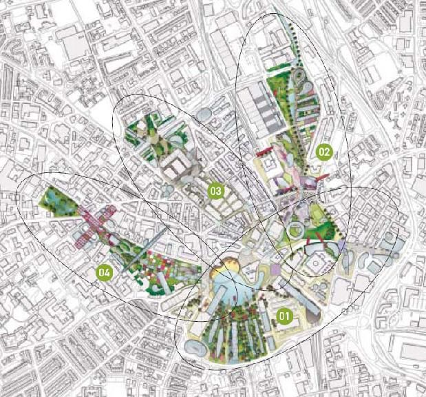
The Masterplan identifies four separate neighbourhoods or ‘fingers of intervention’:
1. The Bowl
2. The Channel
3. The Market
4. The Valley
Figure 03: City Centre Masterplan areas
Each of these areas was subject to a Neighbourhood Development Framework.
The Bowl: The Masterplan proposed a lake around City Hall symbolising its position as a
natural meeting point for the city. The pool was bounded by a Business Forest of new offices
and a Pier built into the pool accommodated screens for digital performances. A strategy was
explored to implement the lake by creating a ‘mirror pool’.
The Channel: The Masterplan proposed a new urban village in the Channel along a
reopened canal. As part of the NDF, the Channel Urban Village together with a new gateway
development around Forster Square Station and proposals for Festival Square in Little
Germany and the Cathedral Quarter Urban Village.
9
The Market: The Masterplan proposed the World Mile as a new shopping destination
together with a Garden of Tranquillity over Drewton Road. The strategy within the NDF is
based on improving the public realm between these poles, particularly through Rawson
Square together with the creation of an urban village around the northern fringe of the area.

The Valley: The plan proposed a valley park along the Bradford Beck, framed by the two
towers of the Odeon. The park included ecology areas, an orchard and space for discovery,
experimentation and learning. A learning bridge over the park linked the university and
college to the city centre.

Further information can be found at:
http://www.investinbradford.com/develop-bradford/bradford
masterplans/Bradford+Masterplan

On 16th January 2007, the City of Bradford Metropolitan District Council considered
consultation responses to the NDFs and resolved that comments would be accepted as
evidence for inclusion in the preparation of the City Centre Area Action Plan.

On 7th February 2007, the City of Bradford Metropolitan District Council’s Regulatory &
Appeals Committee resolved that: the four Neighbourhood Development Frameworks for the
City Centre be treated as material considerations in the determination of planning
applications pending the adoption of the Bradford City Centre Action Area Plan.

In addition to the above, a number of background and feasibility studies have been
completed as part of the masterplanning process which has informed this Baseline Report
and the Issues and Options Report. A number of delivery plans are also in the process of
being produced for the city centre, namely the Learning Quarter Design and Delivery
Framework and the Markets Area Delivery Framework.

2.3 Bradford City Centre Design Guide

In 2005 a consultancy team led by Urbed was commissioned to produce a Design Guide for
the city centre. The purpose of the Guide is to articulate the Masterplan vision for the city
centre into a set of design rules. This includes guidance on tall buildings, the character of
streets, enclosure of space and public realm.

The Guide is used to assess the design of new development proposals in the city centre. It
was adopted by the Council in March 2006 as a Supplementary Planning Document (SPD)
following public consultation. As an SPD, the guide is a material consideration when
determining any planning applications within the city centre.

The Bradford City Centre Design Guide can be viewed at –
http://www.bradford.gov.uk/NR/rdonlyres/29F06299-EB7E-4DF5-920C-
A7A5106293FB/0/CityCentreDesignGuide080307.pdf

                                                                                          10
In 2006 consultants Landscape Projects was commissioned to take the public realm
guidance within the City Centre Design Guide further and produce a Streetscape Design
Manual for the city centre. This provides a set of rules and specifies a palette of materials for
new public realm works. The manual is available at:
http://www.investinbradford.com/Resources/Invest%20In%20Bradford/Documents/BCR_Stre
etscape_leaflet.pdf
2.4 Bradford Learning Quarter Design and Delivery Framework
Farrell and Clark Architects were commissioned by the University of Bradford to produce a
masterplan for the University campus area. The study aimed to bring together a number of
development ideas in a format that demonstrates to others the intent of the University. It
seeks to illustrate the possibility for improvements to the public realm by improving and
clarifying the spaces around buildings, improving physical links and routes and allowing the
development of landscaping where appropriate.
The study undertakes an analysis of the area, covering 11 key themes:
1. Green Spaces
2. Car Parking
3. Vehicular Circulation
4. Pedestrian Routes
5. Key Buildings/Pedestrian Space
6. Bus Routes
7. Space Use Analysis
8. Building Heights and Topography
9. Street Patterns
10. Links to College and Coty
11. Cycle Provision
The study recognises a number of issues in these key themes:
Mixed quality green space
Car dominance
Inconsistent poor quality pedestrian routes
Mixed quality public realm
No direct link between bus stops and circulation routes
Poor land use planning
Weak links to the City Centre
The University has also produced an Estate Strategy, 2004-2014. This sets out the
University’s vision for what the campus should look like in the next 10 years (from 2004). The
strategy covers key themes of Security, Landscaping, student facilities, conference facilities
and student accommodation.
112.5 The City Plan
Under the current economic downturn the prospect of attracting significant investment in the
city centre for large schemes appears difficult, suggesting that a renewed approach to
stimulating regeneration in the city centre is needed. The City Plan provides a delivery
framework for Bradford City Centre aiming to stimulate economic development, investment
and regeneration in the area over the next decade.
The idea behind the plan is to develop a shared long-term view with partners on the type of
city centre that is desirable and what they should be working towards. It is intended to be a
local approach to city centre regeneration while building on existing policy documents and
strategies.
Expected outputs from the plan will be:
Enhanced and increased delivery and investment in the city centre.
Development of specific actions to achieve outcomes identified in the city plan.
Greater alignment of delivery and service provision in the city centre.
Alignment of existing priorities and strategies to maximise impact on city centre.
A strategic approach to investment for the city centre.
A city centre partnership approach to aligning activity and supporting community
participation and engagement.
Short, medium and long term delivery targets to measure progress and impact.
The plan will be split into four areas – people, place, prosperity and property. Taken together
these will provide a holistic approach to delivering the aims of the plan.
People – will focus on how people live, work and enjoy the city centre and include specific
elements of delivery including the city centre residential offer, how we use culture and
events, diversification of the city centre offer and the night time economy, education and
skills, health and well-being, social networking and community development.
Place – will build on the planning framework being developed through the Area Action Plan
to ensure we make the best use of space in the city centre and create a place that supports
people to live, work and enjoy. The plan will focus on specific delivery such as the approach
to listed buildings, use of upper floors, approach to design, public realm, sustainability and
access to green space. Place will also involve identifying how a flexible planning framework
can be introduced to encourage economic growth and engagement, such as meanwhile
uses. The place plan will focus on creating a smart and sustainable city
Prosperity – The prosperity plan is the binding element of the plan where both the Districts
economy and the City’s economy are woven. The prosperity plan will answer the question as
to how will Bradford, its City and District earn its living, both now and in the future. The plan
will aim to identify measures to increase the wealth and economic well-being of the City and
its residents. It will focus on employment growth though investment and private sector
expansion in the city centre, innovation, and encouraging enterprise and entrepreneurship.
12The prosperity plan will focus on the delivery of the economic potential and current strengths
of Bradford as a Producer City; a city which creates, makes and trades all within a wider
producer district.
Property – focuses on how to create the mechanisms for investment and create a city which
is capable of making decent financial returns on development investment. It will also
articulate how to work with developers and key local partners, such as the Property Forum,
to maximise usage of our immense historical legacy by reducing vacancies and so increasing
the vibrancy of the City.
Approval to start the production and delivery of the City Plan has been endorsed by the
Council’s Executive Committee in December 2012. Initial work will be taken to develop a set
of guiding principles for the plan which will be shared and refined through engagement with
Council Leadership, Local Politicians, partners and stakeholders and local people. This will
occur through formal and informal consultation methods as outlined above. These principles
will then form the basis for the city plan which will bring together a range of products,
projects, policies, plans and programmes into a single coherent and focused approach to
regeneration of the city centre.
2.6 City Centre Growth Zone
The City Centre Growth Zone is a 170ha investment area, covering Bradford city centre and
some of the district’s major economic assets (rail stations, University of Bradford, Bradford
College, Theatres and the National Media Museum etc). It provides a targeted approach to
increasing market confidence, drive up footfall and support investment in the city centre. The
zone has a range of development and commercial opportunities, offering incentives to
business to relocate or expand within it.
The city-centre growth zone has been launched in November 2012. The move, which
involves an investment of £17.2m from Bradford Council and £17.6m from the Government
through the Regional Growth Fund, includes rate rebates for new and existing businesses
that create jobs within the zone. Among the other incentives are skills programmes and
access to super fast broadband. Additionally, some £5 million is being spent on public realm
works in the city, while £4.4 million will be spent on the first steps in the redevelopment of the
former police station.
The zone is made up of a number of parts, taken together these create an ‘offer’ for business
that makes investing or expanding more attractive. Businesses will benefit from:
1 Super-fast broadband and city centre Wi-Fi.
Through the super-connected cities programme residents and businesses will be able to
access superfast broadband (speeds up to 100mbs) along with a city centre Wi-Fi offer. The
super-connected cities programme is focused on the city centres of Bradford and Leeds, the
connecting corridor between the two cities and the growth areas of Shipley-Airedale in
Bradford and the Leeds City Region Enterprise Zone (Aire Valley Leeds).
132 Access to employment and skills support.
The Get Bradford Working Programme has been developed to ensure local people can
access jobs,and employers can get staff with the skills they need. The programme
includes an intermediate job ceation fund, industrial centres of excellence and proposals for
an apprenticeship training agency (ATA). This programme operates at a district level. Further
information will be made available when the Get Bradford Working scheme is launched.
3 A responsive and flexible planning system.
The growth zone provides a range of development and commercial opportunities, suitable for
a range of city centre uses. The Local Planning Authority are committed to ensuring these
opportunities are maximised and guarantee a flexible and responsive approach to planning,
including a comprehensive pre-application service and a fast track approach to processing
city centre planning applications. For more information visit: -www.bradford.gov.uk/planning.
4 City Centre Business Growth Scheme.
Businesses that create new, additional jobs (see ‘Additionality’ and ‘Displacement’ in
definition of terms at the end of this briefing) will be able to benefit from a business rates
rebate scheme. In short, every new full time equivalent job created by an eligible business
within the growth zone will be worth a rebate of up to £16,000 on their annual rates payable
bill. Businesses that bring disused space back into permanent commercial use as a result of
creating new jobs will also be able to access a one off rebate to cover any increased rates
bills from the new space.
5. Physical infrastructure and public realm improvements
Capital investment to begin the re-development of the Tyrls area and to improve the links
between Westfield and the wider city centre also form part of the zone.
14As noted before, the growth zone is supported by a range of funding streams including
Council resources and Government funding, including £17.6m from the Government’s
Regional Growth Fund (RGF).
The scheme is anticipated to generate significant job outputs within the city centre by
incentivising job creation and investment across the city centre – over the lifetime of the RGF
programme we anticipate 2,600 full time equivalent jobs will be created across a range of
sectors. This figure includes the projected jobs created by Westfield as well as across the
wider growth zone. As per RGF criteria employment impacts will be monitored until 2021/22.
This is in recognition from Government that employment impacts may ramp up more slowly
than RGF spend.
2.7 Super Connected Cities Programme
In December 2010, the Government launched the National Broadband Strategy setting out
the vision for broadband in the UK, aiming to ensure the country has the best superfast
broadband in Europe by 2015. As part of the implementation, Bradford Council has been
developing the Super Connect Cities programme, aiming for Bradford and Leeds to be the
first two cities outside London with large-scale access to free Wi-Fi and an open access
infrastructure delivering ultrafast broadband.
The Government has recently confirmed that £14.4m will be invested in both Bradford and
Leeds broadband capabilities through Super Connected Cities programme. This will act as a
catalyst for new ways of delivering public services and stimulating economic growth in both
these cities.
In Bradford, the scheme will provide speeds of 100Mbps or more to all premises within the
core area – the city centre, out towards Shipley, the transport corridor into Bradford, and the
Aire Valley.
The first phase of the project is to bring free public wi-fi to both Leeds and Bradford city
centres and it is expected to be in place early next year. Virgin Media Business has
confirmed that it will be installing the “small cell” technology in time to go live from January
2013 with the free wi-fi which is three times the speed of 3G services.
The first locations to benefit from the services will be Bridge Street in Bradford and Briggate
in Leeds in time for the new year, followed by City Park in Bradford and Millennium Square in
Leeds early in 2013.
Ultra-fast broadband will offer high-tech and digital companies the infrastructure they need,
allowing Bradford to compete for business, investment and jobs. It also offers free city centre
wide Wi-Fi service, Wi-Fi connectivity for passengers on trains and buses between Bradford
and Leeds, and Wi-Fi community hubs focusing on libraries.
15Bradford City Centre Baseline Information
3.0 Built Form and Character
3.1 City Centre Townscape
The townscape and built form of Bradford City Centre varies quite dramatically depending on
location. The building and street forms are very varied in their ages, styles, layout, footprints,
heights, materials, condition and general appearance. The topography of the City Centre is
also varied.
The city was built at the confluence of four streams flowing northwards into the Bradford
Beck. These streams create a natural bowl in a valley that flows down from the west to a
relatively flat area around City Hall before flowing onwards down the valley to the north.
Figure 04: Topography of Bradford City Centre Source: City Centre Design Guide
16The market area of the city centre is to the west and built on a spur of land jutting onto the
valley. The market is almost at the top of the hill and the land falls away steeply towards
Thornton Road and beyond Manor Row. To the east of the centre the land rises again up
Church Bank and Little Germany. There is a similar hill to the south west rising up to the
University and a further hill to the south east.
The oldest roads into Bradford come over these four hills. However the roads built in the
Victorian era travel along the valley bottoms, notably Manchester Road, Leeds Road, Valley
Road and Thornton Road. Because of the topography of the city, most of these arrival routes
do not provide good views of the centre. By contrast the high roads provide commanding
views on arrival to the city centre.
The most important of the main tall buildings in the city centre is City Hall which stands in the
centre of the bowl. The tower of City Hall rises from the lowest part of the city centre –
somewhat like an upturned drawing pin. This is important because City Hall is generally seen
against a backdrop of the city, rather that the sky. Most of the other tall buildings keep clear
of the view of City Hall, the main exception being Arndale House, which is out of scale with
its surroundings. Most of the social housing tower blocks are out of the centre and relatively
unobtrusive.
While it is difficult to generalise, there is a tendency for the higher buildings to be in the
valleys. This tends to smooth out the effects of topography so that the buildings appear to fill
up the alley areas. In Little Germany and Goitside the buildings stack up the hill creating
dramatic long views. By contrast to the east of Manor Row the slope is too steep and the
buildings on the ridge create a dramatic cliff-like edge.
3.2 Key Landuse Character Areas
Traditionally the city centre was a dense mix of commercial and industrial development
alongside workers’ housing, administrative functions, cultural uses and shopping. In the last
50 or so years the housing and industrial uses have all but disappeared while the retailing,
commerce and administrative uses have broadly held their own and uses such as the
university and cultural facilities have expanded.
Administrative and cultural uses: These are concentrated in the southern part of the city
centre. City Hall stands in the heart of the administrative quarter together with the police
station and Magistrates Courts (both of which are to be relocated as part of the City Centre
Masterplan). The main Council Offices are in Jacob’s Well, Britannia House and on Nelson
Street. Cultural facilities are grouped around City Hall including the Alhambra Theatre, St.
Georges Hall, the National Media Museum and the Central Library.
Commercial uses: This is perhaps where the greatest change has taken place. The city’s
commercial trade was dominated by the worsted industry including the ‘stuff’ warehouses of
Thornton Road where textiles were stored and processed and the ‘piece’ warehouses of
Little Germany where the textiles were traded. Textiles have now been replaced by sectors
such as banking, financial services and mail order mostly located in new offices around the
17edge of the centre and outside the town with plentiful parking. This has left vacant office
space in the centre that could be used for other uses such as housing. The ‘Stuff’
warehousing has tended to remain in low rent occupation while in Little Germany there has
been some success in letting space to small and creative businesses.
Figure 05: City Centre Landuse Map Source: City Centre Design Guide
Housing: The last of the slum housing was cleared in the 1960s and for years the only city
centre housing was on Church Bank and Chain Street. A city centre housing market has
been late developing in Bradford however schemes have been successful in areas like Little
Germany and the market is expanding rapidly as residential developers explore both new
build and refurbishment schemes in centre.
Retailing: The retail core runs from Well Street between Cheapside and Westgate to St.
John’s Market. This area has declined in recent years and there are advanced proposals to
18redevelop the entire eastern part of the area as the Broadway Shopping Centre. There is
also some unsympathetic ‘big box’ retailing stretching up Valley Road to the north.
Education: The University and College are based on a campus to the west of the city centre.
Both institutions have promoted masterplans to reassess their relationship with the centre.
3.3 Built Heritage
The built heritage of Bradford City Centre straddles the very interface between two historic
visions of Bradford: the Bradford predominantly of the Victorian age and the Bradford
predominantly of the post-war age.
Bradford’s Victorian legacy in particular is of national significance. Although its roots go back
to medieval times, it was rebuilt mostly during the second half of the 19th century during the
boom years of Bradford’s economic development as an international centre of the wool trade.
At its best Bradford’s Victorian townscape rivals any of the great cities in the UK. Much of this
historic form still remains intact, reflected in the fact that there are around 100 Listed
Buildings and four separate conservation areas within the city centre.
The present built environment in the city centre, however, is very much influenced by the
post war redevelopment and has resulted in the loss of some of its historical character. The
majority of the post war redevelopment in the City Centre area, with a few exceptions, has
generally been of a lower quality. From the 1960s onwards it has mainly been unsympathetic
to Bradford as a place in terms of its scale, style and material. These recent developments
rejected the use of continuous building frontages in favour of free standing building within an
open landscape that eventually created unrelated and haphazard composition of buildings
breaking up the spaces and cutting off potentially dramatic view of the townscape.
Spatially, the City Centre can be split roughly into two equal parts- the northern half featuring
Bradford’s Victorian legacies and the southern half representing mostly the post war
redevelopment. The northern half is defined by the conventional urban blocks and streets of
the City Centre Conservation Area and contains many of Bradford’s key heritage and Listed
Buildings. The southern half is defined by free-standing post Second World War buildings
sitting within isolated plots, with ill-defined streets and in part isolated from each other by the
inner-city highway network. The resulting urban fabric in the northern half of the City Centre
is relatively consistent in terms of the pattern of streets and spaces, the height of buildings
and the spacing of blocks, in contrast to the southern half where there is a lack of defined
streets and spaces. The greatest contrast is the latter’s predominance of open space but
almost all of the wrong kind: large areas of inaccessible roadside verges and surface car
parks on waste ground.
The conservation areas in Bradford City Centre comprise a dense network of relatively
narrow streets and tall Victorian buildings creating a coherent civic quarter. Although much
has changed around them, the City Centre architectural heritage remains anchored by the
iconic city hall and the other adjacent St Georges Hall, Little Germany, Cathedral Precinct,
Goitside Area- all reflecting the grand heritage of the district.
19Figure 06: City Centre Listed Buildings and Conservation Areas
Source: City Centre Design Guide
The City Centre: This is the largest conservation area covering the heart of the city. The
area has medieval roots, still seen in the pattern of streets and names such as Ivegate and
Kirkgate. It was however rebuilt in the late 19th century when Bradford was the rapidly
growing international centre of the wool trade. Fortunes were made in 19th century Bradford
and the merchants invested some of this wealth into warehouses, banks, commercial
buildings and public institutions such as the Wool Exchange, City Hall and St. Georges Hall.
These buildings were designed in the honey-coloured local sandstone by local architects.
They create an exuberant, confident city centre which while much altered retains its
character.
Little Germany: To the east of the centre lies Little Germany, built on sloping land by
worsted merchants (many originally from Germany and Eastern Europe). This too is a result
of Bradford’s late heyday and the buildings are ornate ‘piece’ warehouses creating, arguably
20the finest merchant’s quarter in the country. 55 of the area’s 85 buildings are listed and its
character is based on sloping streets with the warehouses getting higher lower down the hill
to create a dramatic townscape.
Cathedral Precinct: This is one of the oldest parts of Bradford and the Cathedral is perhaps
the most important building. The area was one of the first parts of the city to industrialise with
the arrival of the Bradford Canal in the 1770s. The lower part includes some important
commercial buildings while the slopes west of this were once housing and are now surface
parking. There are 16 listed buildings in the area.
Goitside: To the west of the city centre the Goitside conservation area takes in many of the
‘stuff’ warehouses. The Goit is a medieval water channel built to power a corn mill and the
area was already industrialised at the start of the 19th century. It was completely redeveloped
in the late 19th century since when it has remained largely untouched. It contains only 6
listed buildings, however the group value of the buildings is far greater because it remains a
largely complete urban landscape, typical of 19th century Bradford.
Detail Conservation Area Assessments for the four conservation areas in the city centre can
be found at: www.bradford.gov.uk/conservationassessments. Bradford’s listed building
descriptions can be found at www.bradford.gov.uk/listedbuildings.
4.0 Social and Demographic Information
4.1 Population
The population of the wider city centre is estimated to be approaching 4,000. These
residents are primarily located in social housing to the North West and North East of the city
centre. However, since 2001 increasing numbers of privately rented and owner occupied
apartments are being developed in the north of the city centre and Little Germany.
Continued growth in the employment demands and opportunities, change in the type and
capacity of residential development and increasing number of student population have made
it difficult to draw a firm conclusions on the typical characteristics of the city centre
population.
Population change in the city centre as a whole is expected to be influenced by
several factors including the growth in the size and type of residential property and the limits
placed on this by planning policy. The Genecon (2007)1 study assumes that with a
predicted increase in the proportion of 1/2 bedroom property the population of the city
centre could increase by approximately 7,500 by 2014.
1Genecon (2007). BCR Performance Framework: Second Annual Update 2005/06-Final report.
Report Dated August 2007. Genecon Consultancy Ltd.
21The 2001 census shows that the resident population is ethnically diverse, mostly of working
age (20-39 years old) with a very small percentage of children and families and with a high
proportion of single individuals. In a report produced by DTZ and Tescom2 in 2005 shows
that 40% of the city centre residents are aged between 20 and 29 years and 70% of them
live in single person household. So evidently, continued growth in the city centre resident
population will increase the demands for services within the centre, with the most likely
requirement being for shops and leisure facilities rather that for child or health care services.
4.2 Housing
City Centre residents are primarily located in social housing to the north-west and north-
east of the city centre. However, since 2001 increasing numbers of privately rented
and owner occupied apartments are being developed in the north of the city centre
and in Little Germany to accommodate the growing population. Continued growth in the
employment demands and opportunities, change in the type and capacity of residential
development and increasing number of student population have made it difficult to draw a
firm conclusions on the typical characteristics of the city centre population. The current
housing stocks however comprise a large number of small properties with a low level of
higher value properties offering little diversity in the stock.
The majority (82%) of the existing housing in the city centre is flats with nominal amounts of
terraced and semi detached units. Young, single person or small households are the key
market for city centre housing as 70% of the existing housing stock is comprised of single
person accommodation. Housing tenure across owner occupation (30%), private renting
(34%) and social renting (32%) are broadly similar.
In terms of tenure, the level of home ownership (36%) in the city centre is lower than the
district as a whole and the majority of the housing stock is rented in private (34%) and social
(32%) sector. This points to a limited available choice for a large percentage of city centre
population and gives an indication of the affordability problem in the City Centre.
At present, there are no housing allocations in the city centre and no target has been set for
new housing in the city centre. The types of housing being built in the city centre are being
left to the market to decide and the market trend still remains on developing high density
flatted accommodation in one and two-bed apartments. There have been some three-bed
apartments but these are in the minority. According to the 2001 Census, over 80% of all
dwellings are flats, conversions or shared dwellings.
To date most of Bradford’s city living residential stock has been developed through
conversion of old and underused mill buildings, most notably in Little Germany and the
Manor Row area and partly in other similar areas such as Goitside. However, more recently
a number of new build residential developments have come to the market such as the 133
unit Gatehaus scheme and the Empress, a new scheme comprising 45 one and two
2
DTZ and Tescom (2005). Creating a Balanced City Centre Housing Market in Bradford: Final Report.
Report Dated November 2005. DTZ Pieda Consulting and Tescom Research and Consultancy Ltd.
22bedroom luxury units situated in the heart of Bradford, and overlooking the attractive
Centenary Square. Works has also started on the Aspire Citygate project at the bottom of
Manchester Road. York-based developer Skelwith Group is to build 75 homes as part of
phase one of the project. There is also plans to build 362 apartments on a vacant plot at
Trafalgar Street and Snowden Street, near the junction of Manningham Lane and Hamm
Strasse.
The proposed residential development is split into three buildings and includes a 14-storey
tower, 164 studio apartments, 109 one-bed and 89 two-bed apartments, shops, cafes, offices
and leisure units.
The city centre may offer sites large enough to accommodate family housing, however, this
use would be more suited to sites in the peripheral areas due to competition for land in the
city centre and the requirement to maximise density for optimum return.
4.3 Education and Health Facilities
There are no primary and secondary education facilities within the City Centre boundary.
However, there are a good number of schools, academies and free schools within a mile
radius from the city centre. The city centre also falls within the catchment of private and
voluntary run further education facilities and contains adult training centres.
The demand for school places is very much depended on the increase of the city centre
population and whether this population includes children. Currently, only a small fraction of
households within the city centre are home to school-going children which means that there
are no imminent issues regarding the provision of schooling in the city centre. At the
moment, the children who live in the city centre travel out to the surrounding area for their
schooling. However, it has been predicted that the city centre population is likely to increase,
mainly be due to the increase in the 20-39 age group, and the provision of education facilities
and their accessibility will only become more of an issue if this gives a rise in the number of
families with children in the city centre.
In terms of higher and further education, the University of Bradford and Bradford College are
both located within the city centre. Together they attract thousands of students from a variety
of location, ethnicity and culture into the city centre. There is also easy communication from
the City Centre to Leeds to access Leeds University and Leeds Metropolitan University. The
Cathedral Centre also offers adult vocational training facilities within the area.
There are three GP surgeries within Bradford city centre. Two are located close to the
University and the other is in the Market Neighbourhood, which is currently reviewing the
service it offers in the area and may choose to close down in the future. In terms of dental
surgeries, the offer in the City Centre is poor; however, there are at least three surgeries
within 1.5km of City Hall. There are also several chemists within walking distance of
the residential areas. These services and facilities have been established based on current
levels of demand and it is recognised that as the city centre population grows, additional
23provisions are likely to follow. The Bradford Royal Infirmary and the St Luke Hospital are
also within 10 minutes driving distance from the city centre.
4.4 Other Community Facilities
In terms of local, small-scale convenience shopping facilities there is a clear lack of this type
of retail offer in the city centre close to the residential areas. There are a few small shops in
Little Germany and close to the University. The newly opened Tesco Express on Sunbridge
road has also increased small-scale convenience retail offer in the city centre. Morrisons is
the only supermarket to be located in the city centre and this is likely to have an effect on the
presence of smaller convenience retailers in close proximity. However, this store does not
open on Sundays and in 2006 it was announced that it was to close. It remains to be seen if
another retailer is to take over this site.
The city centre is also home to two post offices (although these service facilities had
seriously been reduced with the closure of the largest post office on Bank Street since 19
November 2005), two major hotel chains, leisure exchange (Cineworld leisure complex), the
central bus station (the interchange) and two rail stations.
The Bradford South police station is based at Trafalgar House on Nelson Street bordering
the Southest boundary of the city centre. The Bradford South Division of the police work with
council and other partners to promote community safety and provide enjoyable reassured
visit to city centre. The nearest Fire Station is located on Leeds Road, only 1.3 miles away
from the heart of the city centre.
Bradford Central Library is located on Princes Way, next to the National Media Museum.
Both of these establishments together with the country’s only ‘colour museum’ attract large
number of visitors daily from all over the districts.
Culture Fusion, a new £6.9m state of the art youth facility, is also located in the city centre. It
co-locates a range of services: Bradford city centre Connexions Centre, Information Shop for
Young People and City of Bradford YMCA. The 3000 sqm building also provides a wide
range of open access services for young people during the day and runs as a ‘youth club’
with a wide range of activities during the evenings and weekends. Facilities include: music
studio, performance area, dance studio, activity rooms, youth café and youth hostel.
Bradford City Football Club Stadium is on Manningham Lane, approximately half a mile from
the city centre, which attracts a large number of fans and visitors alike on every match day.
The nearest household waste recycle centre is also on the periphery of the city centre- just
over half a mile away from the northern boundary.
244.5 Transport and Movement
The transport network into and out of Bradford City Centre is extensive, well used
and consists of various different modes travelling on many different routes and
directions towards, within and away from the City Centre.
City Centre Road Network
The original roads into Bradford were on the high ground. Westgate / Wakefield Road were
originally a Roman Road and crossed the river at the ‘Broad Ford’ from which Bradford takes
its name. Later in the Victorian era the valley bottom was developed and new roads were
built. These together with the dense network of minor roads created the shape of the city - a
huge spider’s web of connected streets tying the city together. This street layout is very
permeable and there is also a strong hierarchy of routes.
There are nine main routes into the city centre from the outlaying towns and suburbs
of Bradford and surrounding areas. These vary in terms of quality, capacity and usage and
are detailed as follows:
1) Canal Road/Shipley Airedale Road – this route takes traffic to/from towns of
Shipley, Bingley, Keighley and Ilkley and all other suburbs to the north as well as consisting
of the main A650 accommodating a vast amount of traffic travelling to/from the
northwest of England.
2) Barkerend Road – this route brings traffic from the north eastern suburbs of Bradford and
also acts as one of the main routes to/from Leeds Bradford International Airport.
3) Leeds Road – comes into the City from the Leeds direction and forms one of
busiest routes into Bradford
4) Wakefield Road – one of two routes bringing traffic from the motorway network into the
city centre from the southeast
5) Manchester Road - intersects the city centre from the south and is the second
route bringing traffic from the motorway network.
6) Little Horton Lane – provide the routes out of the city the densely developed residential
areas in the west of the district and to the settlements of Clayton and Queensbury beyond.
7) Thornton Road – A very busy route taking traffic from the City to the western suburbs and
the villages beyond
8) Westgate / Toller Lane – a route taking traffic to the east to Manningham, Heaton and the
more outlying settlements of Allerton, Sandy Lane, Cullingworth and beyond.
259) Manningham Lane – this route takes traffic through an area of Manningham towards
the towns of Shipley, Bingley and Keighley as well as other settlements in the north-
west of Bradford District
Bradford city centre has two ring roads – the Central Ring Road which offers car access into
the very heart of the city and the City Ring which takes traffic out of the centre.
The Central Ring Road was built in the 1960s diverting traffic around the city centre but
cutting the central area off from its surroundings. The City Ring has been developed more
recently to take through traffic out of the centre altogether. The western leg of this has not
been completed although there are plans to extend it to Thornton Road. The result is that
large amounts of traffic still pass through the city centre proper.
The central part of City Centre is further fragmented by predominance of major roads running
through the centre, namely Princes Way, Hall Ings and Manchester Road. Hall Ings/Princes
Way forms a major roundabout of fast moving vehicles and has the effect of cutting off city
hall from the surrounding area and demoting the public realm.
Due to the current level of development interest in the city centre the amount of traffic using
the centre is likely to grow, which could lead to increased congestion.
Public Transport
Bradford Interchange acts as the principal transportation hub in the city centre that allows for
easy changeovers between buses and trains. The Interchange, sited between Croft Street,
Bridge Street, Hall Ings and Nelson Street and opened in the 1970s contains the main city
centre bus terminus and one of two city centre rail stations. The other station is at the Forster
Square to the north.
Bradford Interchange station is the more strategically significant for the city providing rail
connections to cities south, east and west. The station itself sits on the upper side of the
southern boundary of the city centre, which introduces passengers to the city from an
elevated position. The immediately adjacent bus station concourse is at the same level but
there is no direct level access from bus to rail. Instead passengers need to travel down onto
a lower concourse before climbing back up onto the bus or rail platform level.
This bus terminus hosts virtually all of the bus routes in the city although some services lay
over on Hall Ings, Channing Way and Market Street. The current bus station was remodelled
in the 1990s when the lower deck of the then station was changed to commercial use, while
the upper deck was rationalised, reducing the footprint of the bus lay over areas and
constructing a new covered passenger waiting area.
First Group presently run the majority of the local bus network around Bradford, including the
high-frequency core ‘Overground’ network, and services to Leeds, Halifax and Huddersfield.
Other services are run by:
26You can also read