Tornadoes in the New York Metropolitan Region: Climatology and Multiscale Analysis of Two Events
←
→
Page content transcription
If your browser does not render page correctly, please read the page content below

1326                                       WEATHER AND FORECASTING                                                           VOLUME 27

                           Tornadoes in the New York Metropolitan Region:
                           Climatology and Multiscale Analysis of Two Events

                                      BRIAN A. COLLE AND KELLY A. LOMBARDO
                   School of Marine and Atmospheric Sciences, Stony Brook University, Stony Brook, New York

                           JEFFREY S. TONGUE, WILLIAM GOODMAN, AND NELSON VAZ
                                         NOAA/National Weather Service, Upton, New York

                                  (Manuscript received 18 January 2012, in final form 31 July 2012)

                                                            ABSTRACT

               This paper describes the climatology of tornadoes around New York City (NYC) and Long Island (LI),
             New York, and the structural evolution of two tornadic events that affected NYC on 8 August 2007 and 16
             September 2010. Nearly half (18 of 34 events from 1950 to 2010) of NYC–LI tornadoes developed between
             0500 and 1300 EDT, and August is the peak tornado month as compared to July for most of the northeast
             United States. A spatial composite highlights the approaching midlevel trough, moderate most unstable
             convective available potential energy (MUCAPE), and frontogenesis along a low-level baroclinic zone.
             Shortly before the early morning tornadoes on 8 August 2007, a mesoscale convective system intensified in the
             lee of the Appalachians in a region of low-level frontogenesis and moderate MUCAPE (;1500 J kg21).
             Warm advection at low levels and evaporative cooling within an elevated mixed layer (EML) ahead of the
             mesoscale convective system (MCS) helped steepen the low-level lapse rates. Meanwhile, a surface mesolow
             along a quasi-stationary frontal zone enhanced the warm advection and low-level shear. The late afternoon
             event on 16 September 2010 was characterized by a quasi-linear convective system (QLCS) that also featured
             an EML aloft, a surface mesolow just west of NYC, low-level frontogenesis, and a southerly low-level jet
             ahead of an approaching midlevel trough. The QLCS intensified approaching NYC and generated meso-
             vortices as the QLCS bowed outward. These cases illustrate the benefit of high-density surface observations,
             terminal Doppler radars, and sounding profiles from commercial aircraft for nowcasting these events.

1. Introduction                                                      quasi-linear convective system (QLCS) developed over
                                                                     eastern New Jersey and tracked east across New York
a. Background
                                                                     City and Long Island. The QLCS spawned two torna-
   Early in the morning of 8 August 2007, a large meso-              does (EF0 and EF1) in Brooklyn and Queens, New
scale convective system (MCS) produced two tornadoes                 York, respectively, during the late afternoon hours,
in the New York City, New York (NYC), area (Fig. 1).                 causing one fatality [National Climatic Data Center
At 1022 UTC, a tornado classified as a category 1 storm              (NCDC) Storm Data].
on the enhanced Fujita scale (EF1) occurred on Staten                   Wurman et al. (2007) remarked on the potential cat-
Island, New York, and at 1035 UTC, the same meso-                    astrophic damage that could occur if a violent tornado
cylcone produced an EF2 tornado in Brooklyn, New                     impacted Manhattan, New York, stating that the dam-
York. The tornadoes occurred less than an hour after                 age ‘‘would far exceed the economic cost of the de-
sunrise (1030 UTC), well before the maximum heating                  struction of high-rise structures on 11 September 2001,
of the day. It was the first documented tornado in                   though the number of fatalities is difficult to estimate.’’
Brooklyn in over 100 yr. On 16 September 2010, a                     The 8 August 2007 event caused tens of millions of
                                                                     dollars in damage, and the associated severe flash
                                                                     flooding [8.8 cm in 4 h at John F. Kennedy International
  Corresponding author address: Dr. Brian A. Colle, School of
Marine and Atmospheric Sciences, Stony Brook University, Stony       Airport (JFK) in southern Queens] disrupted subway
Brook, NY 11794-5000.                                                and surface transportation throughout the city. Al-
E-mail: brian.colle@stonybrook.edu                                   though there have been only nine reported tornadoes in

DOI: 10.1175/WAF-D-12-00006.1

Ó 2012 American Meteorological Society
                                                                                             Unauthenticated | Downloaded 01/21/22 11:53 AM UTC
DECEMBER 2012                                         COLLE ET AL.                                                             1327

                     FIG. 1. The northeastern U.S. and NYC domains (see black region in inset panel) used in this
                  study. NYC regional map, with the inset map, shows the available surface stations (gray dots)
                  and terminal Doppler radars at the black box locations (TJFK and TEWR). The EF1–2 tor-
                  nado track for the 8 Aug 2007 track is in gray and the EF0 and EF1 tracks for the 16 September
                  2010 case are in black. Terrain is gray shaded every 50 m.

the New York metropolitan region in the past 58 yr                 Colle (2011) showed that tornadoes formed equally
(NCDC Storm Data), anticipating the potential for                  from isolated cells and quasi-linear and nonlinear
tornadoes around NYC can save lives and help protect               structures.
property.                                                             The percentage of tornado events over the north-
   Several studies have highlighted conditions favorable           eastern United States has been categorized by the
for tornadic activity over the northeastern United                 midlevel (500 hPa) flow patterns (Giordano and Fritsch
States. Tornadoes in this region tend to occur between             1991; Johns and Dorr 1996). Tornadoes occurred with
June and August, with the peak in activity in July (David          midlevel flow from the northwest (33%), southwest
1977; Giordano and Fritsch 1991; Johns and Dorr 1996;              (55%), and west (12%). Separating the data into two
Brooks et al. 2003). Johns and Dorr (1996) found that              flow regimes, David (1977) illustrated that a surface
significant tornadoes [some ranked as category 2 on the            pressure trough exists in the lee of the Appalachians
Fujita scale (F2) and greater] occur primarily between             under both northwesterly (2708–3508) and southwesterly
1700 and 0000 UTC for New England and eastern New                  (1808–2708) low-level flow. During the southwesterly
York. Across the mid-Atlantic region, there is a bimodal           flow regime, there is often a cold front located to the
distribution for the development of strong (F3 or                  west of the lee trough to help lift a parcel to its level of
greater) tornadoes (Giordano and Fritsch 1991), with               free convection (LFC). Northwest flow events tend to be
one peak between 1700 and 2200 UTC and the second                  confined to the warm season, with the maximum fre-
maximum between 2300 and 0300 UTC. Lombardo and                    quency occurring between May and August. There is
Colle (2011) also found a late afternoon peak for tor-             a peak in July, due to the seasonal lag in the availability
nadoes over the northeastern United States, and they               of low-level moisture for this flow regime (Johns 1982).
showed that most tornadoes in this region developed                During periods of northwest flow, there is an average of
from isolated cellular storms and QLCSs. Meanwhile,                ;158 of directional shear between 850 and 500 hPa over
near the southern New England coast, Lombardo and                  the northeast United States (Johns 1984). For the other

                                                                                          Unauthenticated | Downloaded 01/21/22 11:53 AM UTC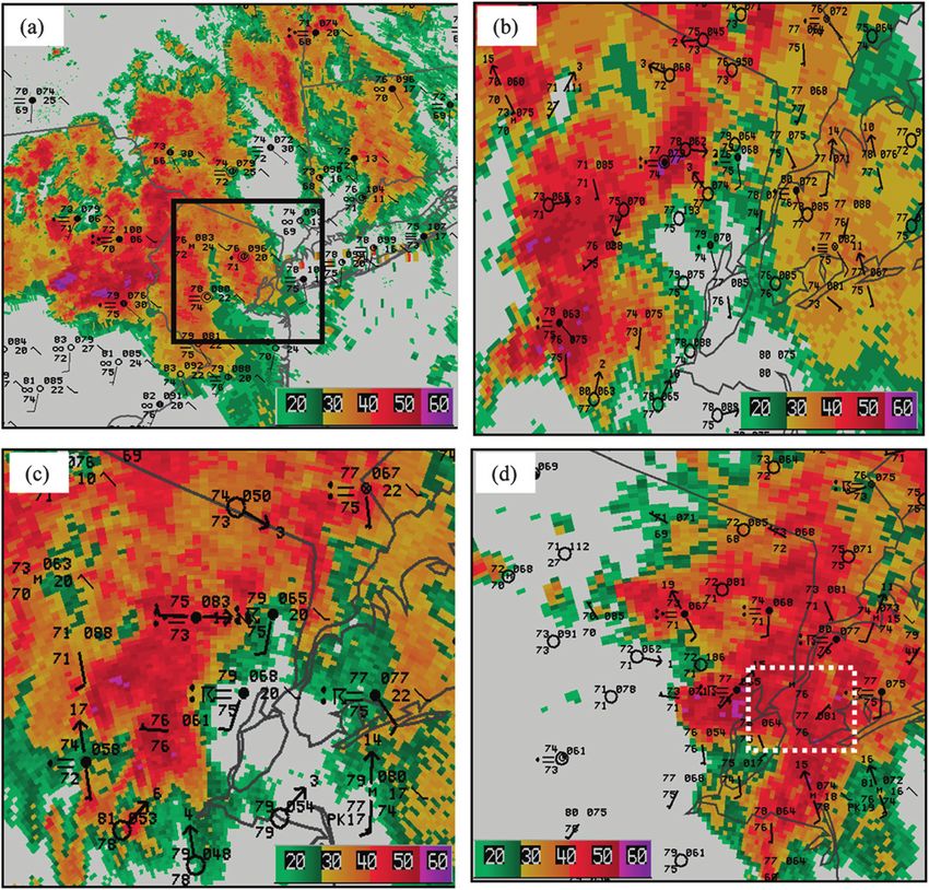
1328                                  WEATHER AND FORECASTING                                                   VOLUME 27

wind patterns, tornadoes develop with little (,58) di-       low most unstable convective available potential energy
rectional shear in this layer.                               (MUCAPE) but large quasigeostrophic forcing. The
   Most of the analysis of tornadogenesis over the           synoptic and mesoscale patterns of evolution supportive
northeast United States has focused on terrain in-           of tornadoes in this coastal environment have not been
fluences. Wasula et al. (2002) linked the spatial distri-    thoroughly investigated. Given the importance of the
bution of tornadoes over New England to the influence        meso- and microscale processes for severe storms, it is
of terrain for different 700-hPa flows. More specifically,   crucial to obtain observations at small scales. In the
terrain flow channeling has been suggested to play an        NYC region, the Aircraft Communications Addressing
important role in tornadogenesis by accelerating the         and Reporting (ACARS) profiles, two Terminal Dop-
low-level flow and thus increasing the shear in the lowest   plar Weather Radars (TDWRs), as well as a regional
kilometer. The F4 tornado at Windsor Locks, Con-             surface mesonet were utilized (Fig. 1). The benefits of
necticut, developed just before 1900 UTC 3 October           these additional observations will be shown.
1979, as a convective cell interacted with a warm frontal       This paper describes the temporal climatology and
boundary associated with a subsynoptic-scale low (Riley      synoptic conditions associated with tornadoes in this
and Bosart 1987). The Great Barrington, Massachusetts,       urban coastal region. Our paper builds on the results of
F3 tornado at 2146 UTC 29 May 1995 occurred in as-           Lombardo and Colle (2011) by focusing on the average
sociation with the confluence of flow channeled up the       synoptic and regional patterns associated with coastal
Hudson Valley merging with an accelerated flow down          tornado events to help improve forecaster pattern
the Catskill Creek (Bosart et al. 2006). The Mechanic-       recognition. Some of the large-scale features and any
ville, New York, tornado (F2) at 2022 UTC 31 May 1998        variations from this climatology are illustrated using
developed as a supercell interacted with southerly flow      two NYC tornado events. The 8 August 2007 and
up the Husdon Valley (LaPenta et al. 2005). Tornadic         16 September 2010 events fit within the northwest and
activity in Pennsylvania peaks in the northwestern and       southwest flow regimes, respectively, which are the two
southeastern regions of the state, with a minimum over       most common flow regimes for tornadic convection
the terrain in the central region of the state (Nese and     over the northeast United States (Giordano and Fritsch
Forbes 1998). Warm, moist low-level air may be chan-         1991; Johns and Dorr 1996). The higher-resolution
neled east and west of the Appalachian crest, thus in-       TDWR, ACARS, and surface observations are pre-
hibiting the development of severe storms over central       sented to help improve forecaster understanding of the
Pennsylvania.                                                mesoscale structures during these two tornado events.
                                                             Neither of these events was well anticipated by fore-
b. Motivation
                                                             casters. For example, the area forecast discussion by
   While most previous studies of tornadic convection        the National Weather Service (NWS) Forecast Office
over the northeast United States have investigated ter-      for New York City issued just a few hours before the
rain influences, we focus on the area around NYC and         September 2010 event mentioned a potential for strong
the surrounding coastal region. There have been no           storms, but the probability for severe weather was
formal case studies of tornado events around NYC,            considered to be quite low. There were also no severe
a highly populated region with over 10 million residents.    thunderstorm or tornado watch or mesoscale convec-
To more accurately warn the public during these events,      tive discussions issued by the Storm Prediction Center
forecasters require an understanding of the conditions       for these events. A major goal of this paper is to high-
that favor the tornado development in this coastal area.     light the synoptic and mesoscale evolution associated
A few key synoptic-scale ingredients have been high-         with NYC tornadoes by addressing the following mo-
lighted for the entire northeast United States (David        tivational questions:
1977; Giordano and Fritsch 1991; Johns and Dorr 1996).
                                                             d   What synoptic-scale conditions support tornado de-
More recently, Lombardo and Colle (2011) provided
                                                                 velopment around NYC?
some regional composites for all severe weather asso-
                                                             d   What is the role of the low-level baroclinic zones and
ciated with convective cells and linear and nonlinear
                                                                 elevated mixed layers?
convective systems along the northeast U.S. coast.
                                                             d   How important are the mesonet and terminal Doppler
They highlighted the importance of the Appalachian
                                                                 radars in nowcasting these events?
lee trough and low-level thermal ridge for severe con-
                                                             d   What is the monthly and diurnal climatology for
vective cells, while linear severe systems develop with
                                                                 tornadoes around the NYC region?
relatively large vertical wind shear along a frontoge-
netical boundary just west of the coast. They also             Section 2 will describe the data and methods used
showed that severe nonlinear systems have relatively         to examine the NYC tornado events. A monthly and

                                                                                  Unauthenticated | Downloaded 01/21/22 11:53 AM UTC
DECEMBER 2012                                        COLLE ET AL.                                                         1329

TABLE 1. Dates for the 20 tornado events for the NYC–LI region   provided by Weather Services International (WSI)
       (inset in Fig. 2a) used in the NARR composites.           and the National Center for Atmospheric Research
1800 UTC 10 Aug 1979                   1200 UTC 8 Aug 1999       (NCAR), illustrated the regional convective evolution
1800 UTC 5 Aug 1981                    0900 UTC 15 Sep 2000      patterns. The Weather Surveillance Radar-1988 Doppler
1800 UTC 25 Aug 1982                   0300 UTC 30 Jun 2001      (WSR-88D) level II reflectivity data from Upton, New
1500 UTC 30 Aug 1985                   1800 UTC 11 Jul 2001      York (KOKX), and Fort Dix, New Jersey (KDIX),
1500 UTC 5 Oct 1985                    0000 UTC 13 Aug 2005
                                                                 provided a more detailed look at the convection at key
1500 UTC 19 Aug 1991                   1500 UTC 25 Aug 2006
2100 UTC 23 Jul 1995                   1200 UTC 18 Jul 2007      times during the storm’s evolution. To analyze the
2100 UTC 26 Jun 1997                   0900 UTC 8 Aug 2007       evolution of the tornadic mesocyclones and precip-
1200 UTC 30 Jun 1998                   1800 UTC 25 Jul 2010      itation structures around NYC, the TDWRs located
1800 UTC 9 Jul 1998                    2100 UTC 16 Sep 2010      near JFK and EWR airports (TJFK and TEWR) were
                                                                 used (Fig. 1), which sampled reflectivity and radial ve-
                                                                 locity data every minute at a 0.38 elevation scan for
                                                                 TEWR and 0.58 at TJFK.
diurnal climatology and synoptic composites will be
presented in section 3. Two case studies are used to
highlight some of the composite structures and meso-             3. Climatology and composite evolution
scale details for the August 2007 and 16 September 2010
                                                                    A climatology and composite analysis of NYC area
events in sections 4 and 5, respectively. A discussion and
                                                                 tornado events is presented to highlight monthly and
summary will be provided in section 6.
                                                                 diurnal frequency as well as some important synoptic
                                                                 precursors. The monthly and diurnal distributions of
                                                                 tornadoes for NYC–LI region were compared with
2. Data and methods
                                                                 those of the northeastern United States and the south-
  The events for the coastal tornado climatology were            ern Connecticut region (Fig. 2a). The southern Con-
identified utilizing both the Storm Prediction Center            necticut region is similar in size to the NYC–LI region
(SPC) and NCDC storm reports archives from 1950                  and illustrates how the climatology can change over
to 2010. To evaluate the synoptic and thermodynamic              a relatively small distance to the north of the Atlantic
conditions that support tornadoes over the coastal zone,         coast.
spatial composites were constructed for the 20 torna-               The monthly distribution of 34 documented [National
does around NYC, Long Island, and southern Con-                  Oceanic and Atmospheric Administration (NOAA)
necticut from 1979 to 2010 (Table 1) using the North             storm reports] tornado events for the NYC–LI area
American Regional Reanalysis (NARR) at 32-km grid                from 1950 to 2010 is shown in Fig. 2a. Tornadoes in this
spacing (Mesinger et al. 2006). The closest 3-h NARR             area occurred mainly from June through October, with
time prior to the tornado report was used. For this study,       the maximum number of events occurring in August. In
MUCAPE uses a parcel with the maximum equivalent                 contrast, areas farther inland across the Northeast have
potential temperature ue in each 30-hPa layer from 0 to          a peak in tornadic activity during July (David 1977;
180 hPa above the ground.                                        Johns and Dorr 1996; Nese and Forbes 1998; Wasula
  The synoptic environments for the August 2007 and              et al. 2002; Brooks et al. 2003). Over coastal Connecticut
September 2010 NYC tornado events were examined                  (46 cases within approximately 30 km of the coast)
using the Rapid Update Cycle (RUC) analysis grids                a July maximum is also observed (Fig. 2a).
available hourly at 80-, 20-, and 13-km grid spacing                Lombardo and Colle (2011) showed that the coastal
every 3 h. The 80-km grid was used for the large-scale           northeastern U.S. tornadoes are skewed slightly toward
analysis and quasigeostrophic diagnostics, while the             the morning and early afternoon hours, but their anal-
20- and 13-km grids were applied to the regional and             ysis included the full northeast U.S. coastal region. To
thermodynamical analyses for the 2007 and 2010                   illustrate some of the diurnal variations from the coast to
events, respectively. Hourly surface observations were           slightly inland, the diurnal analysis was repeated for two
used, including surface data from the MesoWest mes-              smaller areas (coastal Connecticut versus NYC–LI).
onet archive (Horel et al. 2002). Standard radiosonde            While tornadoes over coastal Connecticut can occur at
soundings were utilized in conjunction with the ACARS            any time of the day, there is a clear maximum in the
profiles from LaGuardia Airport (LGA), Newark Lib-               number of reports from 2100 to 0000 UTC (Fig. 2b). In
erty International Airport (EWR), and JFK (cf. Fig. 1).          contrast, for NYC–LI, only ;25 km to the south of Con-
  Several different ground-based radar datasets were used.       necticut, there is a preference for tornado development
The National Operational Weather Radar (NOWrad),                 during the early morning through early afternoon hours

                                                                                     Unauthenticated | Downloaded 01/21/22 11:53 AM UTC
1330                                         WEATHER AND FORECASTING                                                       VOLUME 27

                                                                       significant between the NYC–LI and Connecticut re-
                                                                       gions. A closer examination of the 20 NYC–LI cases
                                                                       reveals that there were 7 Appalachian lee trough events,
                                                                       6 cold front events, 5 warm front events, 1 stationary
                                                                       front event, and 1 tropical cyclone event (Hurricane Bob
                                                                       1991). Although Long Island tornadoes develop under
                                                                       a variety of scenarios, several important ingredients are
                                                                       common to many of the events.
                                                                          In the composite, at 1 day prior to the tornado event
                                                                       (T 2 24 h), a 300-hPa westerly jet extends across the
                                                                       northeastern tier of the United States (Fig. 3a). By the
                                                                       time of the event (T 2 0 h), the upper-level jet becomes
                                                                       amplified to 25 m s21, with NYC near the equatorward
                                                                       jet entrance region, which is a favored region for large-
                                                                       scale ascent (Fig. 3b). The axis of the upper-level trough
                                                                       is located along the Eastern Seaboard into Canada.
                                                                       Meanwhile, a 700-hPa shortwave embedded in west-
                                                                       northwesterly flow is located over the upper Midwest
                                                                       around Wisconsin. There is associated 700-hPa upward
                                                                       motion just east of this trough axis (Fig. 3a). This short-
                                                                       wave trough amplifies as it moves eastward over the
                                                                       Appalachians during the next day, with enhanced mid-
                                                                       level ascent over NYC (Fig. 3b).
                                                                          At the surface, 1 day prior to the tornado events (Fig. 4a),
                                                                       there is a westward extension of the subtropical high over
                                                                       the western Atlantic into the southeast United States.
                                                                       Meanwhile, there is a weak trough extending north–
                                                                       south across the upper Midwest. Over the NYC–LI area,
                                                                       there are relatively light 1000-hPa westerly winds
  FIG. 2. (a) Monthly distribution of tornado events from 1950 to      (,3 m s21) that are nearly parallel to a west–east zone of
2010 for southern CT (black) and LI (gray), with the two regions       relatively large ue differences. The reservoir of MUCAPE
shown in the inset panel. (b) The diurnal tornado distribution every
                                                                       is south of the baroclinic zone over the central United
3 h for NYC–LI (gray) and southern CT (black) for the 1950–2010
period.                                                                States and the mid-Atlantic.
                                                                          The surface composite at T 2 0 h reveals the presence
                                                                       of a trough in the lee of the Appalachians, and this
(0900–1800 UTC). The difference between the mean                       trough extends northward into a parent cyclone over
number of southern Connecticut tornadoes that develop                  northern New York. The southwesterly wind ahead of
between 1800 and 0600 UTC was tested against the                       the trough advects higher values of 1000-hPa ue north-
mean number of LI tornadoes that form during the same                  ward toward NYC–LI. Consequently, the average
12-h time period using a two-sided t test. This difference             MUCAPE over the region increased from 500 to over
was significant to the 95% level. The differences in these             1000 J kg21 (Figs. 4a,b).
means were also tested using a bootstrap analysis tech-                   The composites show that the 0–1-km shear was
nique, yielding a statistical significance of 90%. Overall,            ;10 m s21 on average around NYC at T 2 0 h (not
the Connecticut late afternoon maximum in tornado                      shown), which falls within the range expected for tor-
development is significantly different from the NYC–LI                 nadogenesis (Markowski et al. 2003). Also, previous
morning to early afternoon maximum.                                    studies have shown that a relatively low lifted conden-
  Spatial composites using the NARR were created for                   sation level (LCL) favors tornadogenesis (Rasmussen
the NYC–LI (20 cases of NYC–LI events from 1979                        and Blanchard 1998), since a relatively strong cold pool
through 2010 in Table 1) and southern Connecticut re-                  from evaporation can rapidly cutoff and weaken the
gions. The composite was created for a group of cases by               mesocyclone from the warm and unstable air. The
averaging a particular field of interest at each grid point            composite LCL is 920 hPa at T 2 0 h, which is consistent
on the NARR grid. Only the NYC–LI region results are                   with the mean LCL for the tornado events over the
presented since the differences were not statistically                 central United States (Rasmussen and Blanchard 1998).

                                                                                             Unauthenticated | Downloaded 01/21/22 11:53 AM UTC
DECEMBER 2012                                         COLLE ET AL.                                                           1331

                                                                     FIG. 4. Large-scale composite of NYC–LI tornado events show-
   FIG. 3. Large-scale composite of NYC–LI tornado events         ing sea level pressure (every 2 hPa), ue (dashed every 4 K), wind
showing 300-hPa isotachs (shaded every 5 m s21 starting at        (full barb 5 10 m s21), and MUCAPE shaded (every 250 J kg21) at
15 m s21), 700-hPa geopotential heights (solid every 30 m), and   (a) T 2 24 and (b) T 2 0 h.
700-hPa omega (every 1 3 1023 s21, with positive solid and neg-
ative dashed) at (a) T 2 24 and (b) T 2 0 h.
                                                                  flow across the upper Midwest to the northeastern
                                                                  United States. One short-wave trough was located over
4. 7–8 August 2007 event                                          the central Great Lakes, while another was over the
                                                                  upper Midwest and southern Canada. The 300-hPa jet
a. Large-scale analysis
                                                                  was located well north along the Canadian border at
   At the surface at 1200 UTC 7 August (Fig. 5a), which           1200 UTC 7 August (Fig. 5b), and it remained well to
is about 22 h before the tornadoes affected the NYC               the north of southern New England during this event
area, there was a weak surface cyclone located over the           (not shown), so it was likely not much of a factor across
central Great Plains (;1006 hPa) and northern Min-                the NYC region.
nesota (;1004 hPa), with a warm and stationary front                 At 1300–1600 UTC 7 August, the most active con-
extending across the western and southern Great Lakes,            vection was located along Lake Erie as well as parts of
respectively. An MCS that originated over Iowa at                 southwest Ontario, northeast Ohio, and northwest
0600 UTC 7 August 2007 had moved eastward to the                  Pennsylvania (Figs. 6b,c). The MCS continued to pro-
north of the stationary front (not shown), causing se-            duce severe wind and hail across northeast Ohio around
vere wind and hail from southern Iowa to southern                 this time (Fig. 6a). Shortly after 1600 UTC (not shown),
Michigan overnight and into the early morning on                  the convection weakened as the MCS moved into
7 August (Fig. 6a). Meanwhile, there was surface high             western Pennsylvania. This weakening occurred during
pressure and weak surface winds from the northern                 peak diurnal heating, with surface temperatures aver-
Gulf of Mexico northeastward to New England. At                   aging 328C and the MUCAPE exceeding 2000 J kg21
700 hPa (Fig. 5b), there was a broad ridge centered               across western Pennsylvania (not shown). However, at
over the southeastern United States, with nearly zonal            1500 UTC 7 August, western Pennsylvania was under

                                                                                        Unauthenticated | Downloaded 01/21/22 11:53 AM UTC
1332                                     WEATHER AND FORECASTING                                                    VOLUME 27

                                                                 (Fig. 7c). Convection began to reorganize slightly south of
                                                                 this 700-hPa QG ascent over northwestern Pennsylvania
                                                                 (Fig. 6d) in a region of warm advection (Fig. 7d). At
                                                                 0600 UTC, the 700-hPa QG ascent is still situated over
                                                                 northern New Jersey (not shown). Meanwhile, the con-
                                                                 vection became more organized and intense across eastern
                                                                 Pennsylvania to northern New Jersey (Fig. 6e), which
                                                                 subsequently moved over the NYC area by 1000 UTC
                                                                 8 August (Fig. 6f).
                                                                 b. Mesoscale analysis
                                                                    At 0000 UTC 8 August, relatively weak anticyclonic
                                                                 flow at 925 hPa was centered over eastern Pennsylva-
                                                                 nia and New Jersey, with weak westerlies over NYC
                                                                 (Fig. 8a). The axis of moderate MUCAPE (500–
                                                                 2500 J kg21) and a maximum in ue at 925 hPa (;350 K)
                                                                 extended northeastward into eastern Pennsylvania and
                                                                 New Jersey. By 0600 UTC 8 August, 925 hPa ue . 350 K
                                                                 and a MUCAPE . 2000 J kg21 extended northward
                                                                 along the coastline as the 925-hPa winds became more
                                                                 southerly (Fig. 8b). At the surface, the lee trough deep-
                                                                 ened and pressure within a mesoscale low over eastern
                                                                 Pennsylvania fell to 1007.5 hPa (Fig. 9a). By 0600 UTC
                                                                 8 August, convection had developed around the surface
                                                                 trough axis over northeast Pennsylvania (Fig. 6e), and
                                                                 was moving into a region of moderate to high MUCAPE
                                                                 over New Jersey.
                                                                    Elevated mixed layers (EMLs) have been shown to be
                                                                 important for northeast U.S. severe weather events
                                                                 (Banacos and Ekster 2010). During this event, there was
                                                                 an EML between 800 and 600 hPa, with a relatively
                                                                 steep lapse rate in the RUC analysis (7.58–88C km21) in
                                                                 this layer over the Great Lakes at 1200 UTC 6 August
                                                                 (Fig. 10a). This EML had originated just east of the
   FIG. 5. (a) National Centers for Environmental Prediction
(NCEP) surface analysis and conventional station models (8F)     Rocky Mountains over the central and northern plains
from 1200 UTC 7 Aug 2007. (b) The 700-hPa geopotential heights   on 4 August 2007. The west-northwest flow at midlevels
(solid every 60 m) and 300-hPa wind speeds (gray shaded in kt    advected this EML eastward to western New York and
using inset scale) at 1200 UTC 7 Aug 2007.                       Pennsylvania by 1200 UTC 7 August (Fig. 10b) and
                                                                 just off the Northeast coast by 1200 UTC 8 August
                                                                 (Fig. 10d). The EML is present in the Pittsburgh, Penn-
the short-wave 700-hPa ridge (Fig. 7a), with 100 J kg21          sylvania, sounding at 1200 UTC 7 August (Fig. 10c), with
of surface-based convective inhibition (SBCIN), 0–3-km           a ;88C km21 lapse rate and relatively dry air between
shear less than 5 m s21 (not shown), and there was little        800 and 600 hPa. At 0305 UTC 8 August (Fig. 11a), an
Q-vector forcing and low-level frontogenesis (Figs. 7a,b).       elevated layer of steep lapse rates was present be-
Thus, there was little shear to maintain the convection          tween 800 and 600 hPa at Newark (EWR in Fig. 1). At
or synoptic forcing to help lift parcels to their LFC            0300 UTC 8 August, the RUC sounding profile illus-
(;850 hPa). By 2300 UTC 7 August (Fig. 6d), the main             trates relatively dry air and nearly dry-adiabatic lapse
region of stratiform precipitation advanced ahead of the         rate between 750 and 650 hPa (Fig. 11c), although the
midlevel short wave from central New York to eastern             lapse rate was not as steep as in earlier observations.
Pennsylvania.                                                       By 0600 UTC 8 August, the leading edge of the pre-
  By 0300 UTC 8 August, a 700-hPa short-wave trough              cipitation was approaching the NYC area (Fig. 12a). By
with quasigeostrophic (QG) forcing for ascent (Q-vector          0830 UTC 8 August, there was mainly stratiform pre-
convergence) was located over southern New York                  cipitation pattern around NYC (Fig. 12b). Meanwhile,

                                                                                      Unauthenticated | Downloaded 01/21/22 11:53 AM UTC
DECEMBER 2012                                      COLLE ET AL.                                                          1333

          FIG. 6. (a) Severe storm reports for 7–8 Aug 2007 and composite radar reflectivity at (b) 1500 UTC 7 Aug,
        (c) 2300 UTC 7 Aug, (d) 0300 UTC 8 Aug, (e) 0600 UTC 8 Aug, and (f) 1000 UTC 8 Aug. The blue, green, and red
        dots in (a) are the severe wind, hail, and tornado reports from 0600 UTC 7 Aug to 1000 UTC 8 Aug 2007.

the 0827 UTC 8 August EWR ACARS sounding showed                a more favorable thermodynamic environment for deep
a 58–108C cooling in the 850–700-hPa layer from evapo-         convection around NYC.
ration and adiabatic ascent since 0300 UTC (Fig. 11b).            At the surface at 1000 UTC 8 August (Fig. 9b), the
This created a nearly moist-adiabatic layer between 800        mesolow moved eastward along the surface baroclinic
and 700 hPa, which helped steepen the lapse rate below         zone and was located in northern New Jersey. Surface
this layer. Meanwhile, this cooling stabilized the layer       pressures within the circulation fell to 1006.5 hPa. The
immediately above, which is why the steepest lapse             most intense convection was focused within the north
rates in the 800–600-hPa layer were offshore of the            and northeast quadrants of the mesolow (Figs. 9c,d),
Northeast coast at 1200 UTC 8 August (Fig. 10d). The           where southerly winds and warm advection (isentropic
cooling also is seen in the RUC analyses between 0300          lift) help to focus the convection (Fig. 6b).
and 0900 UTC (Fig. 11c), although the magnitude of                Meanwhile, the low-level shear became more en-
the cooling was less in the RUC than in the ACARS              hanced as the 925 hPa southwesterly winds increased to
observations. Although the RUC MUCAPE values                   ;15 m s21 over NYC by 0826 UTC 8 August (Fig. 11b).
across NYC (;1500 J kg21) did not change much be-              There are low-level veering winds at EWR, with
tween 0600 and 0900 UTC (Figs. 11b,c), a comparison            a ;22 m s21 southwesterly flow near 800 hPa and at least
between the ACARS profile at EWR and the RUC                   17 m s21 of southwesterly shear in the lowest kilometer
profile at 0900 UTC indicates that the RUC is likely too       (Fig. 11b). This 0–1-km shear is the largest of all severe
stable between 900 and 800 hPa (Figs. 11b,c). Meanwhile,       convective events analyzed by Lombardo and Colle
the LFC in the RUC analysis did drop from ;700 hPa at          (2011) from 2002 to 2007 over the coastal northeast
0600 UTC 8 August to ;850 hPa at 0900 UTC 8 August.            United States. For the east-central United States, Parker
Overall, the leading edge of the MCS helped to create          and Ahijevych (2007) highlighted the importance of

                                                                                    Unauthenticated | Downloaded 01/21/22 11:53 AM UTC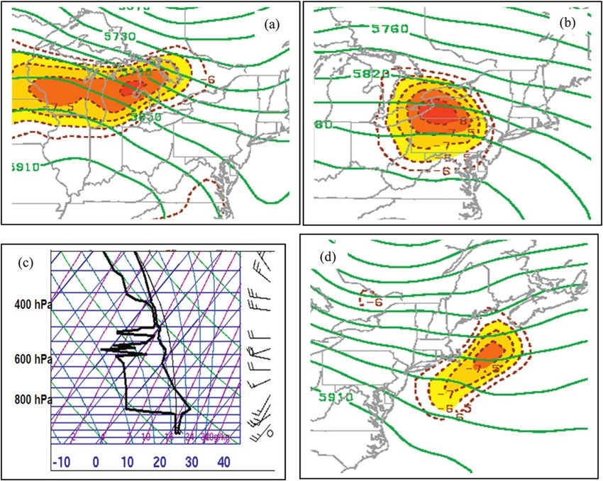
1334                                      WEATHER AND FORECASTING                                                         VOLUME 27

           FIG. 7. (a) The 700-hPa Q vector and Q-vector convergence (shaded in K m21 s21 3 10211), 700-hPa geopotential
        heights (solid, m), 700-hPa omega (dashed, m s21 3 1023) at 1500 UTC 7 Aug 2007. (b) The 950-hPa frontogenesis
        [shaded, 1 K (100 km)21 (3 h)21 3 1021], potential temperature (dashed, every 2 K), and winds (full barb 5 10 kt) at
        1500 UTC 7 Aug 2007. (c) As in (a), at for 0300 UTC 8 Aug 2007. (d) As in (b), but at 0300 UTC 8 Aug 2007.

lower-tropospheric shear for the organization of meso-             MCS moved over NYC and was associated with the tor-
scale convection. Furthermore, the importance of low-              nadic convection.
level environmental shear for tornadogenesis has been                 The intense cell approaching northern Staten Island
well documented throughout the literature (Weisman                 around 1013 UTC was associated with a wind-shift line
and Klemp 1982, Brooks et al. 1994; Thompson et al.                with westerly winds to the rear (Fig. 12d), which was
2003; Markowski et al. 2003). For example, Thompson                attached to the surface trough over northern New
et al. (2003) and Markowski et al. (2003) showed that all          Jersey (Fig. 9b). Meanwhile, the surface temperatures
cases with tornadoes and significant tornadoes (F2 or              were approximately 758–778F (23.98–258C) around
greater) over the central plains have mean 0–1-km ver-             Staten Island and NYC, and 738–748F (22.88–23.38C) to
tical wind shears of 6–8 and 10–12 m s21, respectively.            the northwest of the trough axis and convective system
The enhanced environmental shear present at EWR                    (Fig. 12d), so there was no well-defined cold pool with
suggests that the MCS had the potential to become tor-             this system. On the southern boundary of this intense
nadic when approaching the NYC area. Within this                   convection, a mesocyclone developed along this wind-
evolving environment, the leading edge of the convective           shift boundary approaching northern Staten Island.
area at 0930 UTC 8 August weakened as it moved into                Over a period of 10 min, the gate-to-gate shear in-
northeastern New Jersey (Fig. 12c), while a second, more           creased from 6.5 to 26 m s21 (not shown). By 1017 UTC,
linear, region of convection organized along the surface           a weak mesocyclone using the TEWR radar (radar beam
trough boundary located over north-central New Jersey.             height was 300–400 m) was crossing northern Staten
At 1013 UTC 8 August (Fig. 12d), this back edge of the             Island (Fig. 13b).

                                                                                           Unauthenticated | Downloaded 01/21/22 11:53 AM UTC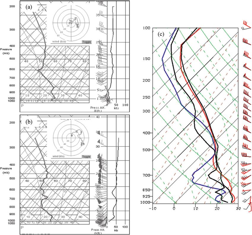
DECEMBER 2012                                          COLLE ET AL.                                                              1335

                                                                      FIG. 9. Manual surface analysis showing sea level pressure (solid
                                                                    every 1 hPa) and surface temperature (dashed, every 28C) at (a)
                                                                    0600 and (b) 1000 UTC 8 Aug 2007.

                                                                    velocity couplet just east of Staten Island at 1029 UTC.
                                                                    This circulation was relatively shallow, with the velocity
                                                                    couplet much weaker by 1300 m AGL (Fig. 14b). A
                                                                    tornado warning was issued for NYC at 1028 UTC as
                                                                    this mesocyclone intensified and an EF1 tornado
   FIG. 8. MUCAPE gray shaded every 500 J kg21 starting at          touched down near eastern Staten Island and the en-
500 J kg21 for 925-hPa ue (dashed, every 5 K) and 925-hPa winds     trance to New York Harbor (Fig. 1 and dashed circle in
(full barb 5 10 kt) at (a) 0000, (b) 0600, and (c) 0900 UTC 8 Aug
2007 from the RUC analyses. NYC is shown at the location marked
                                                                    Fig. 13c). By this time, the tornadic circulation was
by X.                                                               embedded within a shield of moderate precipitation
                                                                    (Fig. 13a). By 1035 UTC (Figs. 13d and 14c), the me-
                                                                    socyclone circulation moved into Brooklyn and pro-
   By 1027 UTC the circulation over northern Staten                 duced an EF2 tornado. A cross section through this
Island merged with another low-level circulation that               velocity couplet at this time illustrates that the circula-
had developed to the northeast of Staten Island and                 tion was mainly below 1500 m AGL (Fig. 14d). This
drifted southeastward to the entrance of New York                   circulation tracked eastward into central Brooklyn by
Harbor (Fig. 14a). Figure 13c shows the well-defined                1040 UTC (not shown). By 1043 UTC, the mesocyclone

                                                                                           Unauthenticated | Downloaded 01/21/22 11:53 AM UTC
1336 WEATHER AND FORECASTING VOLUME 27
FIG. 10. Average lapse rate (shaded, 8C km21) from 800 to 600 hPa using the RUC analyses at (a) 1200 UTC 6 Aug,
(b) 1200 UTC 7 Aug, and (d) 1200 UTC 8 Aug. (c) Pittsburgh sounding at 1200 UTC 7 Aug showing temperature
(8C), dewpoint temperature (8C), and winds (full barb 5 10 kt).
occluded and within minutes dissipated completely (not By 2100 UTC 16 September, as the convective line
shown). was organizing and approaching NYC, a 700-hPa trough
moved eastward to the eastern Great Lakes (Fig. 15c).
Most of the 700-hPa ascent and Q-vector convergence
5. 16 September 2010 event was located over northern New York, Vermont, and
extreme southeastern Ontario, while there was little
a. Large-scale analysis
midlevel ascent and forcing around southern New York
At 1200 UTC 16 September 2010, about 9 h before the and New Jersey at this level. At the surface (Fig. 15d),
severe weather occurred around NYC, there was a short- the cyclone (;1004 hPa) was over eastern Lake Erie,
wave ridge over the northeastern United States at 500 hPa with a surface trough and associated frontogenesis ex-
(Fig. 15a), while midlevel troughs were located over the tending eastward to central New York. The baroclinic
western Great Lakes and western Quebec, Canada. A zone originally over the mid-Atlantic several hours
300-hPa jet extended from Quebec southeastward to earlier was now located from eastern Pennsylvania to
Nova Scotia, Canada. Given its northern location, there Long Island, with an area of 950-hPa frontogenesis
was likely little influence from this upper jet during this around Long Island and parts of southern New England.
event over southern New York. There was a surface cy- As a result, across the NYC area there was frontoge-
clone (;1002 hPa) centered over southern Lake Michigan netical forcing for ascent and a relatively strong low-
(Fig. 15b), with a broad baroclinic zone at 950 hPa ex- level southerly jet (15–20 m s21) at 950 hPa to the south
tending eastward toward the mid-Atlantic coast. Fronto- of Long Island.
genesis at 950 hPa extended from western Pennsylvania to The atmosphere destabilized quickly around NYC dur-
central and southern New Jersey at this time (Fig. 15b). ing the day on 16 September. In the ACARS sounding
Unauthenticated | Downloaded 01/21/22 11:53 AM UTCDECEMBER 2012 COLLE ET AL. 1337
FIG. 11. ACARS temperature and wind profile at EWR at (a) 0305 and (b) 0826 UTC 8 Aug. (c) RUC analysis
sounding at Newark at 0300 UTC (temperature in red and dewpoint temperature in blue) and at 0900 UTC (both
temperature and dewpoint temperature in black) on 8 August.
from JFK at 1234 UTC 16 September (Fig. 16a), there dry-adiabatic layer deepened further from 850 to
was a 38–48C inversion between 950 and 900 hPa asso- 650 hPa and became drier by 2006 UTC 16 September
ciated with the warm frontal zone and veering winds at JFK (Fig. 16c). There were ;900 and ;1200 J kg21
from south-southeasterly to southwesterly. The column of MUCAPE in the JFK sounding and the 2000 UTC
was unsaturated with no MUCAPE at this time. By RUC analysis (not shown), respectively, which is about
1724 UTC 16 September at JFK (Fig. 16b), the low- an hour before the convection moved through.
level inversion had strengthened and deepened up To further illustrate the origin of this nearly dry-
to 850 hPa as a result of the warm advection near the adiabatic layer between 850 and 700 hPa at NYC, the
top of this layer. Meanwhile, there was some backing in lapse rate in this layer is plotted spatially from 0000 UTC
the wind profile from 750 to 650 hPa that was associ- 16 September to 2100 UTC 16 September (Fig. 17). At
ated with cold advection, which led to a temperature 0000 UTC 16 September (Fig. 17a), the greatest lapse
drop of 18–28C around 700 hPa during the preceding rates between 850 and 700 hPa were over the Carolinas
5 h. This resulted in a nearly dry-adiabatic layer be- and Virginia westward to the Ohio River valley. There
tween 850 and 700 hPa and ;400 J kg21 of MUCAPE was no MUCAPE at this time across this region, since
in the JFK sounding. It was also drier in this layer (78– there was a subsidence inversion above 700 hPa and
88C dewpoint depression) as compared to the nearly relatively dry air at low to midlevels (not shown). There
saturated layer between 975 and 900 hPa. This elevated was an anticyclone at 800 hPa over South Carolina as
Unauthenticated | Downloaded 01/21/22 11:53 AM UTC1338 WEATHER AND FORECASTING VOLUME 27
FIG. 12. (a) Regional mosaic of WSR-88D reflectivity for the 0.58 elevation scan (shaded in dBZ) combined with
mesonet station models (in 8F) at 0558 UTC 8 Aug 2007. (b)–(d) As in (a), but for the KDIX (see Fig. 1) radar
reflectivity for the 0.58 elevation scans at (b) 0829, (c) 0930, and (d) 1013 UTC. The dashed white box in (d) is for the
zoomed-in region in Fig. 13.
indicated by the clockwise flow at this level. The winds layer in the JFK ACARS profiles around this time
were westerly or northwesterly over the mid-Atlantic, so (Fig. 16c). Meanwhile, there was an increase in low-level
this air could not be advected northward along the coast MUCAPE toward the coast from western New Jersey
at this time. By 1200 UTC 16 September, the lapse rates (;500 J kg21) to western Long Island (;1500 J kg21),
steepened to .98C (1000 m)21 in the 850–700-hPa layer and the southwesterly flow increased to 10–15 m s21 at
around the eastern Virginia and North Carolina coast 800 hPa across much of the northeast United States.
(Fig. 17b), and there was 500–1500 J kg21 of MUCAPE
b. Mesoscale evolution
across this region given an increase in moisture (ue) near
the surface along the coast (not shown). Southwesterly At 1924 UTC 16 September, there was a broad area of
flow at 800 hPa around Virginia advected this more un- light to moderate (35–40 dBZ) precipitation across
stable air northward toward New Jersey and Long Island. much of eastern Pennsylvania to southeast New York,
By 2100 UTC 16 September, the relatively steep lapse with some stronger embedded convective cells over
rates between 850 and 700 hPa extended northward western New Jersey (Fig. 18a). During the next hour, as
along the mid-Atlantic coast to Long Island. This corre- this precipitation area moved eastward into a region of
sponds to the development of the nearly dry-adiabatic greater instability across central New Jersey (Fig. 18b),
Unauthenticated | Downloaded 01/21/22 11:53 AM UTCDECEMBER 2012 COLLE ET AL. 1339
FIG. 13. (a) TEWR TDWR reflectivity (shaded in dBZ) and available surface stations (in 8F) at 1029 UTC 8 Aug
2007. TJFK TDWR base velocity (shaded in kt) at (b) 1017, (c) 1029, and (d) 1035 UTC 8 Aug 2007. The circulation
center is marked by the dashed circle. The dashed boxes in (c) and (d) are for the regions plotted in Figs. 14a,b and
14c, respectively.
more intense cells (to 50 dBZ) developed along its Island. The Doppler velocities at 2112 UTC indicate
eastern side. At the surface at 2000 UTC 16 September a relatively weak circulation pattern (;15 m s21 gate-
(Fig. 19), there was a mesolow (;1010 hPa) over west- to-gate shear) at this location (Fig. 20b). In just 5 min
ern New Jersey, with the warmest temperatures (278– (2117 UTC), this reflectivity bulge wrapped up into
308C) extending northward along the coastal plain from a well-defined spiral hook (Fig. 20c), with a well-defined
Maryland to central New Jersey. Meanwhile, a 28–38C velocity couplet (40 m s21 gate-to-gate shear) (Fig. 20d).
temperature difference and wind shift (5–10 m s21 The TEWR radar was critical in the observation of this
southerlies to weak northerlies) existed across NYC circulation given its rapid 1-min scans and high spatial
from south to north. By 2112 UTC 16 September, the resolution. For example, the WSR-88D radar from KDIX
convection along the eastern side organized into a line (;45 km to the south-southeast and a center beam height
(to ;60 dBZ) 20–30 km to the west of NYC (Fig. 18c). of ;800 m at this circulation location) did not have
The EWR and JFK TDWRs were used to investigate a well-defined hook or circulation center (Figs. 20e,f).
the detailed evolution of this convective line as it moved There was no confirmation of tornadic damage related
across NYC. At 2112 UTC 16 September using the to this couplet; however, there were spotter reports of
TEWR radar (Fig. 20a), there was an eastward bulge in multiple funnel clouds approximately 5 min earlier as the
the line echo pattern approaching southwest Staten vortex was near the southwest tip of Staten Island.
Unauthenticated | Downloaded 01/21/22 11:53 AM UTC1340 WEATHER AND FORECASTING VOLUME 27
FIG. 14. TEWR TDWR base velocity (shaded in kt) at (a) 1027 UTC at 150 m AGL, (b) 1029 UTC at 1300 m AGL,
and (c) 1034 UTC at 150 m AGL on 8 Aug 2007. The circulation center is located by the dashed circle, and the
locations for these regions are shown in Fig. 13. (d) North–South (NS) cross-section [location shown in (c)]
indicating base velocity from 0 to 2.7 km AGL.
Meanwhile, at 2117 UTC 16 September, there was weaker than 15–20 min earlier. The horizontal scale
another bulge in the convective line and circulation of this mesocyclone (3–4 km) was twice as large as the
center over northwest Staten Island as seen from the 8 August event (1–2 km). The mesocyclone in the
TJFK radar (Figs. 21a,b). This northern Staten Island September event was also deeper than the August
vortex wrapped up into a well-defined hook echo by case (Figs. 22a,b), with a well-defined circulation pat-
2126 UTC (Figs. 21c,d), with strong inbound (245 m s21) tern at 1500 m and extending up to at least 2.5 km
and outbound (20 m s21) base radial velocities from AGL in a velocity cross section (as high as the TEWR
TJFK. At this time a 107-kt wind gust (55.0 m s21 where radar can measure given its cone of silence). This
1 kt 5 0.514 m s21) was recorded at Robbins Reef (see mesocyclone continued northeastward and slowly
RR in Fig. 21d), which is the highest reported wind ever weakened across the north shore of Long Island (not
recorded in the five burroughs of NYC for a convective shown).
event (NOAA/NWS, Upton). During the next 30 min Overall, the tornadoes for this September 2010 event
this mesocyclone moved across New York Harbor and occurred along a QLCS, and were not embedded in the
into Brooklyn and Queens, producing damaging winds southwest quadrant of the MCS as in the 8 August 2007
and the EF0–EF1 tornadoes (Fig. 1). At 2135 UTC, event. Tornadoes along QLCSs have been documented
there was a well-defined eastward bulge in the reflec- over the central United States (Trapp et al. 2005). This
tivity pattern associated with an outbound–inbound case is consistent with the results of Lombardo and Colle
velocity couplet (Figs. 21e,f), which was somewhat (2011), which showed that just as many coastal northeast
Unauthenticated | Downloaded 01/21/22 11:53 AM UTCDECEMBER 2012 COLLE ET AL. 1341
FIG. 15. (a) The 500-hPa geopotential heights (solid every 60 m), winds (full barb 5 10 kt), and 300-hPa wind speed at 1200 UTC 16 Sep.
(b) Sea level pressure (solid, every 2 hPa), 950-hPa potential temperature (dashed, every 2 K), frontogenesis [shaded, 1 K (100 km)21
(3 h)21 3 1021] and wind barbs at 1200 UTC 16 Sep. (c) The 700-hPa geopotential height (solid, every 20 m), Q vectors, Q-vector
convergence (shaded, in K m21 s21 3 10211), and upward motion (dashed, every 1 m s21 3 1023) at 2100 UTC 16 Sep. (d) As in (b), but at
2100 UTC 16 Sep.
U.S. tornadoes occurred for QLCSs as cellular storms This study also highlights the benefits of using some
(isolated supercells). new observational datasets for monitoring convection in
this urban coastal environment, such as the two terminal
Doppler weather radars near John F. Kennedy In-
6. Discussion and summary
ternational Airport (JFK) and Newark Liberty Interna-
Although tornadoes around the New York City (NYC) tional Airport (EWR), aircraft soundings (ACARS),
metropolitan region are relatively rare as compared to the and numerous nonconventional surface observing sta-
midwestern United States, they can occur and do cause tions. The Fort Dix (KDIX) WSR-88D is typically the
significant damage. This paper describes the evolution of first to observe rotating storms approaching NYC from
two tornado events on 8 August 2007 and 16 September central New Jersey given some of the range limitations
2010, both of which spawned two tornadoes across the of the TDWRs; however, the low tilt angles and rapid
NYC region and western Long Island (LI). The results 1-min scans from the TDWRs allowed forecasters to issue
from these case studies are compared to a longer-term tornado warnings with more confidence and monitor the
composite evolution of 20 events across NYC–LI from 1979 evolving mesocyclones in the two NYC cases.
to 2010, and a monthly and diurnal climatology of torna- The 8 August 2007 event was associated with an
does was constructed for this region from 1950 to 2010. MCS that formed 2 days prior in advance of a midlevel
Unauthenticated | Downloaded 01/21/22 11:53 AM UTC1342 WEATHER AND FORECASTING VOLUME 27
FIG. 16. ACARS temperature (red), dewpoint (blue), and wind
profile at JFK at (a) 1234, (b) 1724, and (c) 2006 UTC 16 Sep.
short-wave trough embedded in west-northwest flow.
FIG. 17. Average lapse rate between 850 and 700 hPa (color
Supported by midlevel quasigeostrophic ascent and shaded), MUCAPE (green, every 500 J kg21), and 800-hPa
low-level frontogenesis, the MCS moved eastward winds (full barb 5 10 kt) at (a) 0000, (b) 1200, and (c) 2100 UTC
along a surface baroclinic zone causing severe weather 16 Sep 2010.
from Iowa to Ohio. Upon encountering the complex
Appalachian terrain, the MCS weakened as the con- along a new frontogenetical boundary and associated
vection moved ahead of the midlevel forcing and verti- surface mesolow development. There was enhanced
cal shear. During the overnight hours of 8 August, the near-surface warm advection, frontogenesis, and cyclonic
MCS reintensified in the immediate lee of the terrain shear near the region of tornadogenesis. At this time,
Unauthenticated | Downloaded 01/21/22 11:53 AM UTCDECEMBER 2012 COLLE ET AL. 1343
FIG. 19. Manual surface analysis showing sea level pressure
(solid, every 1 hPa) and surface temperature (dashed, every 28C) at
2000 UTC 16 Sep 2010.
there was midlevel forcing over eastern Pennsylvania
with MUCAPE values approaching 1500 J kg21. A me-
socyclone developed on the southwest boundary of the
heavy precipitation shield, with a tornado causing EF1
and EF2 damage across eastern Staten Island and
Brooklyn, respectively.
The 16 September 2010 QLCS also developed along
the leading edge of the cold pool and interacted with
a west–east baroclinic zone in advance of an upper-level
short-wave trough and surface cyclone over the lower
Great Lakes. The development of a southerly low-level
jet ahead of this system led to rapid destabilization and
frontogenesis over the NYC area on 16 September. The
QLCS intensified rapidly as it approached NYC late in
the afternoon, and low-level vortices developed as the
line bowed outward in a few places.
An intriguing aspect of the August 2007 event was
that the MCS redeveloped and crossed the Appala-
chians at night, and tornadogenesis occurred during the
diurnal minimum of heating (around 0600 EDT). A
climatology of all events revealed that nearly half (18 of
34 events) of NYC–LI tornadoes developed between
0900 and 1800 UTC (0500–1300 EDT). Parker and
Ahijevych (2007) found that a successful MCS crossing
of the Appalachians was favored during periods of
higher instability around peak diurnal heating. In-
stability downstream of the mountains was also im-
portant in maintaining the MCS across the barrier
FIG. 18. Regional mosaic of WSR-88D reflectivity (shaded in
dBZ) for the 0.58 scan at (a) 1924, (b) 2024, and (c) 2112 UTC
(Letkewicz and Parker 2010). The development of
16 Sep 2010. Available surface observations are also shown. The a cold pool in the lee of the barrier can also help re-
solid and dashed boxes in (c) are the radar regions shown in Figs. 20 generate convection (Frame and Markowski 2006). For
and 21, respectively. the 8 August event and several of the composite events,
Unauthenticated | Downloaded 01/21/22 11:53 AM UTC1344 WEATHER AND FORECASTING VOLUME 27
FIG. 20. (a) Radar reflectivity (shaded in dBZ) and (b) base radial velocity (shaded in kt) from TEWR at
2112 UTC 16 Sep for the 0.38 elevation scan for the small solid/dashed region in Fig. 18c. (c),(d) As in (a),(b), but at
2117 UTC 16 Sep 2010. The dashed circled region shows the circulation center developing along the convective line.
The center beam height from TEWR to the circulation is 140 m ASL for (c) and (d). (e) As in (c), but for the KDIX
WSR-88D. (f) As in (d), but for the KDIX WSR-88D. The center beam height from KDIX to the circulation center
(shown by the white dashed circle) 55 km to the NNE is 850 m ASL.
the convection reintensified during the overnight hours advection (16 September) or evaporative cooling and
so there was no diurnal heating, and there is little evi- adiabatic cooling aloft (7–8 August) destabilized the
dence of a well-defined cold pool. Rather, both NYC column in a region of favored synoptic ascent and
convective systems redeveloped as low-level warm relatively strong low-level wind shear.
Unauthenticated | Downloaded 01/21/22 11:53 AM UTCDECEMBER 2012 COLLE ET AL. 1345
FIG. 21. As in Fig. 20, but for the TJFK terminal Doppler radar (0.58 scan) and plotted for the small dashed boxed
region in Fig. 18c showing reflectivity (shaded in dBZ) at (a) 2117, (c) 2126, and (e) 2135 UTC 16 Sep and base radial
velocities (shaded in kt) at (a) 2117, (c) 2126, and (e) 2135 UTC 16 Sep. The dashed circled region shows the
circulation center developing along the convective line. Robbins Reef is shown by RR in (d), which recorded a 107-kt
wind gust. The dashed box in (d) is for the region shown in Fig. 22a.
During the August 2007 event, there was an elevated shown to be important in destabilizing the column for
mixed layer (EML) between 800 and 600 hPa that origi- northeastern U.S. severe weather (Banacos and Ekster
nated from the upper Midwest 2 days prior under west- 2010). During the 8 August event, upward motion (adia-
northwest flow aloft. A steep lapse rate aloft also developed batic cooling) and evaporation of precipitation at the lead-
over NYC during the 16 September event between 850 ing edge of the MCS led to cooling at midlevels within the
and 750 hPa under southwesterly flow. EMLs have been EML, thus helping to steepen the lapse rates at low levels.
Unauthenticated | Downloaded 01/21/22 11:53 AM UTC1346 WEATHER AND FORECASTING VOLUME 27
The diurnal climatology suggests that there may be
different environments supporting tornadoes around
NYC–LI as compared to just 40–50 km to the north over
the mainland. It is hypothesized that the ambient con-
ditions over the NYC–LI region are more maritime than
coastal Connecticut, since NYC–LI experiences a more
direct influence with southerly flow (sea breezes) from
the ocean. First, this causes the peak in annual activity
on LI to occur later in the season (August) when the
surrounding Atlantic waters are at their warmest. Con-
vective systems moving eastward often weaken upon
encountering the cooler New York coastal waters during
June–July (Murray and Colle 2011). In contrast, torna-
does occur in coastal Connecticut near the diurnal
heating maximum, a trend more characteristic of con-
tinental region. The relatively large number of morning
tornadoes over NYC–LI suggests that the diurnal
heating plays a smaller role in tornadic events at the
coast. Rather, unstable air can advect up the coast or an
EML can move in aloft during the early morning and the
midlevels can become further destabilized from evapo-
ration and adiabatic ascent, as in the 8 August 2007
tornado event. Furthermore, Murray and Colle (2011)
showed that convective systems tend to move across the
Appalachians and reach the coastal waters around LI by
the late night, which is similar to the 8 August event.
The composite patterns of the evolution of both the
surface mass field and the instability are similar for the
8 August and 16 September events (Figs. 6b and 12d).
The relatively low to moderate values of MUCAPE
FIG. 22. TEWR TDWR base velocity (shaded in kt) for indicate that large instability is not necessary for tor-
1500 m AGL at 2135 UTC 16 Sep. The location of this region is nado development in the NYC area. In both the com-
shown in Fig. 21f. (b) NS cross-section [location shown in (a)] posite and the individual events, a zonally (east–west)
showing base velocity from 0 to 2.8 km AGL. oriented baroclinic zone is present across northern New
Jersey and NYC at the time of tornadogenesis, which
The composite analysis of all NYC–LI tornado events suggests that baroclinic processes are important for ro-
revealed that there is often an Appalachian lee trough tating storms in the region. Similar features have been
and baroclinic zone that extends west–east across the found for tornadic events in central Florida (Wasula
region, similar to the August 2007 and September 2010 et al. 2007), in which the east–west baroclinic zone
events. The low-level advection of heat and moisture served as low-level frontogenetical forcing for ascent as
ahead of this lee trough helps to destabilize the col- well as a potential source of cyclonic vorticity. Also, they
umn, while frontogenesis helps trigger the convection. noted the importance of surface mesolows along the
Several studies have shown the importance of low- front, which can locally enhance the vorticity and warm
level mesoscale boundaries for the development of advections. The NARR composite cannot capture these
tornadic supercells (Maddox et al. 1980; Markowski small-scale features approaching NYC–LI, but surface
et al. 1998; Rasmussen et al. 2000). Maddox et al. observations in both case studies suggested that there
(1980) diagnosed the role of low-level convergence were surface mesolows along the baroclinic zone (Figs. 6
and the generation of vertical vorticity within a thin and 16).
band along the warm side of a thermal boundary. Both Lombardo and Colle (2011) showed that severe
the 8 August and 16 September events occurred along weather over the northeastern United States can occur
a broad baroclinic zone; thus, this thermal and wind for a wide variety of MUCAPE environments; however,
boundary may have played an important role in en- the lower MUCAPE severe events (,500 J kg21) are
hancing the vorticity within the convective system. typically associated with relatively large dynamical
Unauthenticated | Downloaded 01/21/22 11:53 AM UTCDECEMBER 2012 COLLE ET AL. 1347
forcing. The NYC tornado case studies and composites Bosart, L. F., A. Seimon, K. LaPenta, and M. Dickinson, 2006:
illustrate that there were moderate MUCAPE values Supercell tornadogenesis over complex terrain: The Great
Barrington, Massachusetts, tornado on 29 May 1995. Wea.
(1000–1500 J kg21), relatively large low-level vertical
Forecasting, 21, 897–922.
shear, and synoptic forcing either from quasigeostrophic Brooks, H. E., C. A. Doswell III, and J. Cooper, 1994: On the en-
ascent at midlevels or low-level frontogenesis. The vironments of tornadic and nontornadic mesocyclones. Wea.
composite analysis illustrated that many tornadic events Forecasting, 9, 606–618.
occur near the right-entrance region of an upper-level ——, ——, and M. P. Kay, 2003: Climatological estimates of local
daily tornado probability for the United States. Wea. Fore-
jet. With the approach of an upper-level trough and
casting, 18, 626–640.
front, there is also relatively strong low-level shear for David, C. L., 1977: A study of synoptic conditions associated with
these NYC tornado events, and this shear may be en- New England tornadoes. Preprints, 10th Conf. on Severe Local
hanced by increased cyclonic flow with mesolow de- Storms, Omaha, NE, Amer. Meteor. Soc., 180–185.
velopment near the surface, such as during the 8 August Frame, J., and P. Markowski, 2006: The interaction of simulated
2007 and 16 September 2010 events. The importance of squall lines with idealized mountain ridges. Mon. Wea. Rev.,
134, 1919–1941.
dynamical forcing under relatively weak MUCAPE and Giordano, L. A., and J. M. Fritsch, 1991: Strong tornadoes and
vertical shear conditions is consistent with the findings of flash-flood-producing rainstorms during the warm season in
Markowski and Straka (2000), Monteverdi et al. (2003), the mid-Atlantic region. Wea. Forecasting, 6, 437–455.
and Hanstrum et al. (2002). Hanstrum, B. N., G. A. Mills, A. Watson, J. P. Monteverdi, and C. A.
The 16 September tornado event was associated with Doswell III, 2002: The cool-season tornadoes of California and
southern Australia. Wea. Forecasting, 17, 705–722.
the development of mesovortices and a bowing of the
Horel, J., and Coauthors, 2002: Mesowest: Cooperative mesonets
QLCS as it moved over NYC. One question is whether in the western United States. Bull. Amer. Meteor. Soc., 83,
the coastal boundary enhanced this low-level vortex 211–225.
development. Wheatley and Trapp (2008) showed that Johns, R. H., 1982: A synoptic climatology of northwest flow severe
the vortices with a QLCS can develop in homogeneous weather outbreaks. Part I: Nature and significance. Mon. Wea.
Rev., 110, 1653–1663.
conditions through the tilting of crosswise horizontal
——, 1984: A synoptic climatology of northwest flow severe
baroclinic vorticity in downdrafts, as revealed by the weather outbreaks. Part II: Meteorological parameters and
idealized simulations of Trapp and Weisman (2003). synoptic patterns. Mon. Wea. Rev., 112, 449–464.
Thus, the role of the coast may have been secondary for ——, and R. A. Dorr Jr., 1996: Some meteorological aspects of
the NYC events, but it is interesting that for both cases strong and violent tornado episodes in New England and
eastern New York. Natl. Wea. Dig., 20 (4), 2–12.
the mesocyclone spun up rapidly approaching the coast
LaPenta, K. D., L. F. Bosart, T. J. Galarneau, and M. J. Dickinson,
near western Staten Island. One could speculate that 2005: A multiscale examination of the 31 May 1998 Mechanicville,
the enhanced horizontal shear (vorticity) in the winds New York, tornado. Wea. Forecasting, 20, 494–516.
between water and land may enhance vortex devel- Letkewicz, C. E., and M. D. Parker, 2010: Forecasting the main-
opment. Also, the relatively warm water compared to tenance of mesoscale convective systems crossing the Appa-
the cooler land during the late night or early morning of lachian Mountains. Wea. Forecasting, 25, 1179–1195.
Lombardo, K., and B. A. Colle, 2011: Convective storm structures
late summer may provide some additional low-level and ambient conditions associated with severe weather over
baroclinicity for vortex generation. Separation of the the northeast United States. Wea. Forecasting, 26, 940–956.
coastal effects and internal storm dynamics on rotating Maddox, R. A., L. R. Hoxit, and C. F. Chappell, 1980: A study of
storms in this urban-coastal region will require more tornadic thunderstorm interactions with thermal boundaries.
careful analysis and high-resolution model simulations. Mon. Wea. Rev., 108, 322–336.
Markowski, P. M., and J. M. Straka, 2000: Some observations of
rotating updrafts in low-buoyancy, highly sheared environ-
Acknowledgments. This study was supported by the ments. Mon. Wea. Rev., 128, 449–461.
National Science Foundation (Grant ATM-0705036) ——, E. N. Rasmussen, and J. M. Straka, 1998: The occurrence of
and NOAA-CSTAR (NA10NWS4680003). We appre- tornadoes in supercells interacting with boundaries during
ciate the helpful comments and suggestions from David VORTEX-95. Wea. Forecasting, 13, 852–859.
——, C. Hannon, J. Frame, E. Lancaster, A. Pietrycha, R. Edwards,
Radell and Jeffrey Waldstreicher at Eastern Region
and R. L. Thompson, 2003: Characteristics of vertical wind
Headquarters of the National Weather Service as well profiles near supercells obtained from the Rapid Update Cycle.
as Dr. Erik Rasmussen and two anonymous reviewers. Wea. Forecasting, 18, 1262–1272.
Mesinger, F., and Coauthors, 2006: North American Regional
Reanalysis. Bull. Amer. Meteor. Soc., 87, 343–360.
REFERENCES Monteverdi, J. P., C. A. Doswell III, and G. S. Lipari, 2003: Shear
parameter thresholds for forecasting tornadic thunderstorms in
Banacos, P. C., and M. L. Ekster, 2010: The association of the ele- northern and central California. Wea. Forecasting, 18, 357–370.
vated mixed layer with significant severe weather events in the Murray, J., and B. Colle, 2011: A climatology of convective storms
northeastern United States. Wea. Forecasting, 25, 1082–1102. over the northeast United States. Mon. Wea. Rev., 139, 992–1012.
Unauthenticated | Downloaded 01/21/22 11:53 AM UTCYou can also read