Release Guide WebGIS 2020 Update 1 - Release Guide - Hexagon AB
←
→
Page content transcription
If your browser does not render page correctly, please read the page content below
Release Guide

Release Guide
WebGIS 2020 Update 1

Version 16.6 Update 1
11 August 2020

Contents
Release Guide ............................................................................................................................ 1
   WebGIS Update 1 .................................................................................................................... 1

About This Release .................................................................................................................... 5

GeoMedia WebMap .................................................................................................................... 5

Geospatial Portal ....................................................................................................................... 5

Geospatial SDI............................................................................................................................ 5

New Technology (16.6) .............................................................................................................. 6
   GeoMedia WebMap .................................................................................................................. 6
      GeoMedia WebMap Mobile for Field Data Editing ................................................................. 6
      Mobile Publisher for GeoMedia WebMap Mobile Configurations ........................................... 7
      Performance Improvements .................................................................................................. 8
      Postgres Metadata Connection ............................................................................................. 9
      Live Search Available for GeoMedia WebMap Essentials ................................................... 10
      Enable WebMap WFS-T for all Read-Write Data Servers ................................................... 10
   Geospatial Portal .................................................................................................................... 11
      Enhanced Measurements in Geospatial Portal - Consumer ................................................ 11
      Groups for Layers in Geospatial Portal - Consumer ............................................................ 12
      Legend style icons in Geospatial Portal - Consumer ........................................................... 13
      Support for Custom Layer Graphics in Geospatial Portal - Consumer ................................ 13
      Highlight for Loading Layers in Geospatial Portal - Consumer ............................................ 14
      Information Bar in Geospatial Portal – Consumer ............................................................... 15
      Highlight Active Map Composition in Geospatial Portal - Consumer ................................... 16
      Preserve Bounding Box in Consumer while Map Composition Changes............................. 17
      Enable Feature Information in Consumer with One Click .................................................... 18
      Consumer Feature Info Dialog is Floating (Not Modal) ........................................................ 18
      Feature Info Locatability for WMS/WMPS in Consumer ...................................................... 19
      Display WMS Feature Information with Xlink:href as Hyperlinks ......................................... 20
      Enhanced Printing Rendering for High DPI in Geospatial Portal - Classic........................... 21
      Configurable Width of Live Search Control in Geospatial Portal - Classic ........................... 21
      Languages Support in Geospatial Portal - Classic .............................................................. 21

11 August 2020                                                                                                                            2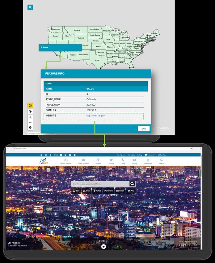
Extrude Analysis Results in Geospatial Portal - Classic ...................................................... 22
     WFS-T Feature Attribute Updates are Reflected in 3D Extrusion in Geospatial Portal -
     Classic ................................................................................................................................ 22
     Display Extruded Data in Geospatial Portal – Consumer .................................................... 23
     Improved 3D Engine ........................................................................................................... 24
  Administration Console ........................................................................................................... 25
     Service Instance Name Displayed During Editing ............................................................... 25
     Improved workflow when starting workspace update in Configuration Portal ...................... 26
     3D View in Configuration Portal .......................................................................................... 27

New Technology (16.6 Update1) ............................................................................................. 28
  GeoMedia WebMap ................................................................................................................ 28
     OGC WFS 2.0 conformance ............................................................................................... 28
  GeoMedia WebMap Mobile .................................................................................................... 29
     Enhanced offline mode........................................................................................................ 29
     Auto-configured primary key ............................................................................................... 31
     Auto-fill values for different data types ................................................................................ 32
     Default values ..................................................................................................................... 33
     Enhanced display of media files .......................................................................................... 34
     Remote server connection to the mobile backend ............................................................... 35
     Enabled multiple connections (handling several sources) ................................................... 36
     Handle multiple map windows and assign works with a map window ................................. 37
     Use map window bounding box (BBOX) as a default .......................................................... 38
     Quick start guide in Mobile Publisher .................................................................................. 39
     Picture style support for the point feature class ................................................................... 40
     Honoring WFS/WMS legend entries locatability in GeoMedia WebMap Mobile .................. 41
     New base maps (Here Maps/Bing Maps) ............................................................................ 42
     Display of GPS accuracy in GeoMedia WebMap Mobile app .............................................. 43
  Geospatial Portal and Consumer ............................................................................................ 44
     New print engine support in Geospatial Portal .................................................................... 44
     Ability to connect to secured WFSG services in Geospatial Portal ...................................... 44
     Search for coordinates in Consumer Portal ......................................................................... 45
     Improved Consumer Portal UI ............................................................................................. 46
     Disable unavailable elements (Search, Go to my location) ................................................. 46

11 August 2020                                                                                                                                3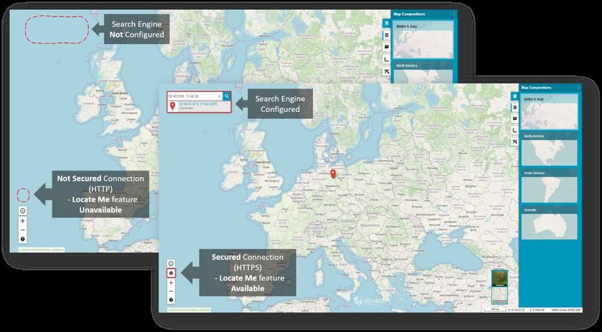
Preserve legend settings between Map Composition switches ........................................... 49
      Base maps in Consumer Portal ........................................................................................... 50
      Using Consumer Portal SDK - dynamically refreshed content............................................. 51

System Requirements ............................................................................................................. 52
   GeoMedia WebMap ................................................................................................................ 52
   Geospatial Portal .................................................................................................................... 54
   Geospatial SDI ....................................................................................................................... 55

Issues Resolved (16.6)............................................................................................................. 57
   Geospatial Server 2020 .......................................................................................................... 57
      GeoMedia WebMap, Geospatial SDI, Geospatial Portal ..................................................... 57

Issues Resolved (16.6 Update 1)............................................................................................. 59
   Geospatial Server 2020 Update 1........................................................................................... 59
      GeoMedia WebMap, Geospatial SDI, Geospatial Portal ..................................................... 59

About Hexagon ........................................................................................................................ 61
   Copyright ................................................................................................................................ 61

11 August 2020                                                                                                                                4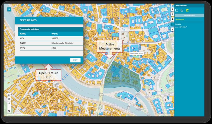
About This Release
This document describes the enhancements for WebGIS products, including GeoMedia WebMap, Geospatial
Portal, and Geospatial SDI. Although the information in this document is current as of the product release, see
the Hexagon Geospatial Support website for the most current version.

This release includes both enhancements and fixes. For information on enhancements, see the New
Technology section. For information on fixes that were made to the WebGIS products for this release, see the
Issues Resolved section.

This document is only an overview and does not provide all the details about the product's capabilities. See the
online help and other documents provided with the WebGIS products for more information.

GeoMedia WebMap
GeoMedia WebMap supports a broad range of customers that require visualization and examination of
geographic data on the Web. From easily creating standards-compliant web services to providing sophisticated
visualization and analysis within interactive web mapping applications, GeoMedia WebMap builds powerful
solutions for sharing your organization’s rich geospatial data.

Geospatial Portal
Geospatial Portal is a fully featured, configurable, and customizable thin client application that can be used for
finding, viewing, querying, analysing, and consuming geospatial data published by Hexagon Geospatial
products and/or other standards-based web services. The portal can be accessed by multiple users via web
browsers as it is installed and configured on a web application server.

Geospatial SDI
Geospatial SDI is an interoperable and scalable component of spatial data infrastructure for cataloging and
delivering enterprise geospatial data over the web. It is designed for data providers who need to manage and
serve secure or licensed information using standards-based web services. It offers powerful tools for controlled
access to standards-compliant services and data published by those services, as well as tools for monitoring
and reporting service performance. The product adheres to Open Geospatial Consortium (OGC®), INSPIRE,
and International Standards Organization (ISO) standards for web services and metadata compliance.
Geospatial SDI can easily extend solutions based on GeoMedia® WebMap, ERDAS® APOLLO, or any other
vendor’s OGC-compliant product to assure the full set of services required for implementation of custom
secure Spatial Data Infrastructure (SDI).

11 August 2020                                                                                                   5
New Technology (16.6)
GeoMedia WebMap

GeoMedia WebMap Mobile for Field Data Editing
GeoMedia WebMap 2020 has a new mobile application for field data editing called GeoMedia WebMap
Mobile. It is a phone/tablet-based application for accessing, portraying and editing geospatial data. The user
can view, edit, validate, and update enterprise GIS data from the field in real time. The updated data on the
mobile device is instantly available for the GIS platform used in the same organization.

The core functionality in GeoMedia WebMap Mobile comes from the Mobile MapWorks product. Mobile
MapWorks users will now find all the familiar functions and features and more in GeoMedia WebMap Mobile.
In addition, because the workflows and available actions are more intuitive and easier to navigate, the user’s
experience is much improved.

The Feature Info panel serves as an example of the many enhancements introduced in GeoMedia WebMap
Mobile. Previously, the user had to decide before selecting an object on a map whether to view or edit the
feature details. If the user noticed a feature that required updates while viewing its details in the Feature Info
panel, they had to close the panel, select edit option and click the feature on the map again to re-open the
Feature Info panel in edit mode. In the new GeoMedia WebMap Mobile, both actions are available directly in
the Feature Info panel. Now, users with editing privileges simply click an attribute, make changes, and then
save the changes by clicking to confirm.

The editable and read-only attributes are easily distinguished with different presentations in the Feature Info
panel. Also, because the Feature Info panel no longer occupies the entire screen, both the properties and the
map are viewable at the same time. It optimizes viewing and editing of feature details; the user can easily
navigate between the features on the map while their details are immediately displayed in the Feature Info

11 August 2020                                                                                                       6

panel. To expand the Feature Info panel to full screen or minimize it, the user simply swipes it up or down,
respectively.

GeoMedia WebMap Mobile can be configured to serve selected data to individual users within a pre-defined
area. It can also be configured to run in offline mode to support field work in areas with weak or no online
access.

GeoMedia WebMap Mobile can be used for all types of field and site inspection workflows, such as pole or
vegetation inspection for utilities or public works, traffic light and bridge inspection for transportation authorities,
and cell or mobile tower site inspection for communications companies.

GeoMedia WebMap Mobile application is downloadable for free from Apple, Google and Windows app stores.
The server side of the GeoMedia WebMap Mobile is offered as part of GeoMedia WebMap Advantage and
Professional.

Mobile Publisher for GeoMedia WebMap Mobile Configurations
Another feature added to GeoMedia WebMap is Mobile Publisher. This feature assists in the set-up and
management of GeoMedia WebMap Mobile configurations by addressing key aspects including user
identification, field zone geometry specification and field work definitions. Mobile Publisher then generates the
configuration files based on the Administrator’s selections.

With Mobile Publisher, configuring GeoMedia WebMap Mobile is easy. The Administrator can:

11 August 2020                                                                                                        7
•   Define GeoMedia WebMap Mobile field users

   •   Create and manage works

   •   Define and apply user access and action permissions

   •   Set feature class attributes and properties

   •   Configure feature class options such as enumeration lists and more…

       Note: Advanced users can also manually change the configuration generated by Mobile Publisher.

Mobile Publisher is available as part of GeoMedia WebMap Publisher, an add-on that is run in GeoMedia.
GeoMedia WebMap Publisher is installed with GeoMedia WebMap but can be also downloaded and installed
separately on a computer that has GeoMedia installed.

Performance Improvements
Several performance improvements were added to GeoMedia WebMap 2020. Efficiency has been enhanced
when performing analyses on GeoMedia WebMap’s WFS feature classes in Geospatial Portal, especially for
data cases and queries, which processes filters using the database engine.

New Server Pools have been introduced to increase the reliability of a GeoMedia WebMap server and
guarantee critical services’ availability.

The administrator can configure Map Server Pools in the Administration Console, then define them in System
Settings and finally, assign the pools to the application(s) and service(s).

11 August 2020                                                                                               8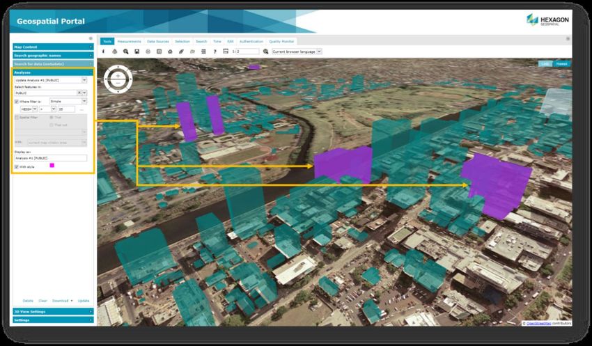
Postgres Metadata Connection
When creating a service source for a GeoMedia WebMap Publisher Portal, WMS (Map), or WFS (Feature)
Service, you must specify a database connection for the service source. Publisher supports four types of
databases. With 2020 release the Postgres database is supported in addition to Microsoft Access, Microsoft
SQL Server and Oracle. You can use a Postgres database not only to store your geospatial data, but also
GeoMedia WebMap services metadata.
Note that metadata can be published both locally and remotely.

11 August 2020                                                                                               9
Live Search Available for GeoMedia WebMap Essentials
GeoMedia WebMap Essentials users can query (registered in Portal) WFS-G services with the new Live
Search functionality. The Live Search control is located on the toolbar in GeoMedia WebMap Publisher Portal.

Enable WebMap WFS-T for all Read-Write Data Servers
Transactional WFS functionality will be enabled when the Service Source contains features from any read-
write GeoMedia Warehouse unless the connection was explicitly opened as read-only. This introduces both
the ability to restrict WFS to work in Read Only mode on some database engines that did not use to provide
such configuration (e.g. SQL Server Spatial) and to setup transactional WFS without the need for installing
database software (e.g. by use of new read-write data servers available in GeoMedia such as GeoPackage
and ESRI file geodatabase). Please note that not all read-write data servers are capable of high-throughput
and reliability in all production environments.

11 August 2020                                                                                                10
Geospatial Portal

Enhanced Measurements in Geospatial Portal - Consumer
Advanced measurement is one of the basic functionalities in Geospatial Portal - Consumer. Users can
measure distances and areas on the map, as well as obtain geographic coordinates of any given point.

The measurements results are displayed in the Measurements (right) panel. With 2020 release the
measurement details are also displayed on the map:

   •   For area measurements: over the measured area.

   •   For linear measurements: both the total length of the polyline and the distance between two points is
       displayed above each segment.

   •   Coordinates: in the tooltip on the map around measured point.

11 August 2020                                                                                             11
Groups for Layers in Geospatial Portal - Consumer Geospatial Portal - Consumer displays the layers grouped under the name of the service the layers come from. Users can change the layer order within the group by drag and drop of individual layer, switch the layer on/off or modify its opacity for optimal map display. 11 August 2020 12
Legend style icons in Geospatial Portal - Consumer
Legend entries from WMS services can now include the icon that reflects the style applied for the layer.

Support for Custom Layer Graphics in Geospatial Portal - Consumer
WMS services may provide custom legend graphics that bring detailed information about presented
phenomena. With the 2020 release the custom graphics are displayed in the legend item control beside the
layer name.

Geospatial Portal – Consumer by default tries to display the legend graphic provided by the service, if it fits the
legend item control (20x15 px). If the legend graphic is larger than the legend item control, it is either
automatically resized to fit the control or replaced with an icon placeholder. The graphic in its original size can
be then displayed on hover.

11 August 2020                                                                                                  13
Highlight for Loading Layers in Geospatial Portal - Consumer
Another new feature shows the legend loading progress on the Geospatial Portal - Consumer’s sidebar. Now,
users can easily see when all layers are loaded without checking them individually regardless of which tab is
active on the right panel, and even when there is no tab open.

11 August 2020                                                                                             14
Information Bar in Geospatial Portal – Consumer
Geographic latitude and longitude for the current cursor position in a map window is displayed in the bottom
right corner on the screen application.

The name of active Map Composition is displayed in the bottom right corner. The coordinate system EPSG
code of the current map is visible on the information bar as well.

11 August 2020                                                                                                 15
Highlight Active Map Composition in Geospatial Portal - Consumer
The active map composition in Geospatial Portal – Consumer is highlighted. This improvement allows users to
easily distinguish which Map Composition is currently displayed.

Administrators can change the highlight color in the style.css file – the file responsible for Geospatial Portal -
Consumer style configurations.

11 August 2020                                                                                                   16
Preserve Bounding Box in Consumer while Map Composition Changes
The administrator can now configure map composition settings for Geospatial Portal – Consumer instances.

The new “When Changing Map Composition” configuration element available in Administration Console for
Consumer instances has two possible settings:

    •   “Set New Variant’s Map Range” – the Consumer uses the map range defined for the Map
        Composition to be displayed.

    •   “Keep Current Map Range and Map Control” – the Consumer retains the current map range when
        switching between Map Compositions, ignoring of the original range defined for the Map Composition
        to be displayed.

The latter setting is useful when adding new sets of layers to be viewed, while retaining the same viewing
range.

In addition, the administrator can enable the map switching option for Consumer end users. The Feature
button will be displayed in the upper right corner of the Map Composition panel.

11 August 2020                                                                                               17
Enable Feature Information in Consumer with One Click When using the Feature Info dialog in Geospatial Portal - Consumer, the tooltip with available layers for the feature area appears. After selecting the layer, the Feature Info dialog is displayed. If only one layer is available, the Feature Info dialog is displayed immediately. Consumer Feature Info Dialog is Floating (Not Modal) The feature Info window is now floating (not modal). Now users can keep it continuously open while simultaneously navigating map layers, performing measurements, and so forth. 11 August 2020 18
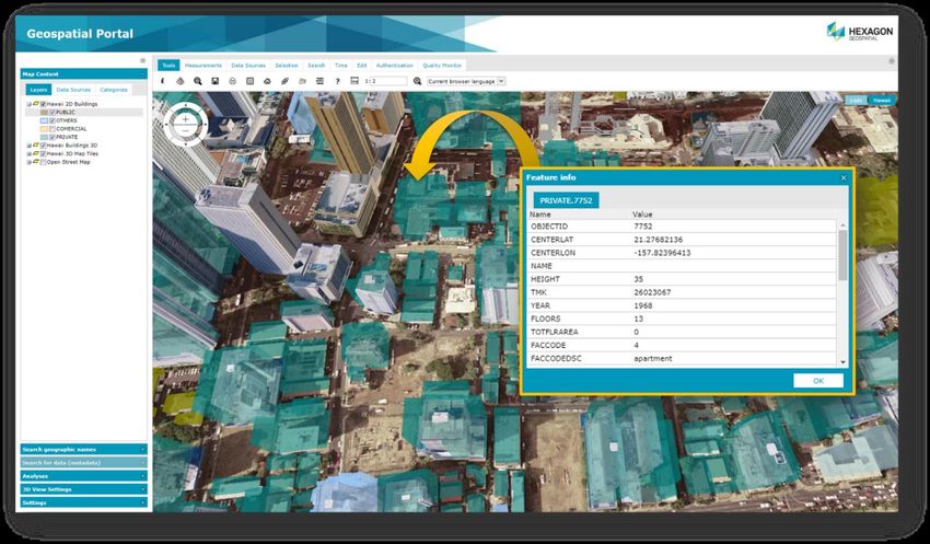
Feature Info Locatability for WMS/WMPS in Consumer
GeoMedia WebMap supports locatability of Feature Info operation for WMS/WMPS services in Geospatial
Portal - Consumer. Users can set locatability (true/false) for a layer in Configuration Portal. Then, the starting
workspace in Geospatial Portal - Consumer will display Feature Info as shown in the table:

Layer setting in Configuration Portal                     Feature Info for particular layer in Geospatial Portal -
                                                          Consumer
Is Locatable = True                                       Feature Info Available
Is Locatable = False                                      No Feature Info Available

11 August 2020                                                                                                   19
Display WMS Feature Information with Xlink:href as Hyperlinks Displaying hyperlinks in attributes was improved by adding Feature Info in XML format. If hyperlink attributes are enabled in GeoMedia WebMap’s WMS layers, Geospatial Portal - Consumer will properly display them as links. A new page or tab will open when the link is clicked. 11 August 2020 20
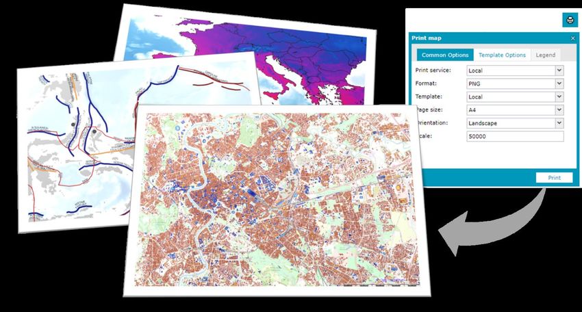
Enhanced Printing Rendering for High DPI in Geospatial Portal - Classic
Improved DPI processing for printouts in the Geospatial Portal - Classic. Higher DPI settings result in better
legibility when printing images with text.

Configurable Width of Live Search Control in Geospatial Portal - Classic
By default, the width of Live Search control is set to 200px. This may cause navigation between pages with
multiple results in some languages difficult. This difficulty was resolved with the option to change the width of
the Live Search combo.

Administrators can choose to display results wider than the combo. By default, the width of the results list is set
to 300px. The minimum width of the result list is larger or equal to the width of the combo box. These settings
can be found in the Web.config file for Geospatial Portal - Classic.

Languages Support in Geospatial Portal - Classic
Geospatial Portal – Classic is a multilingual application with option for a variety of languages out-of-the-box
and continues to enhance its rich set of languages. In this release, Marathi and Bahasa Indonesia were added.

11 August 2020                                                                                                   21
Extrude Analysis Results in Geospatial Portal - Classic
Geospatial Portal - Classic supports extrusion of 2D vector features into three dimensional solid shapes to
build 3D scenes in seconds. The extrusion can be also applied to the layers resulting from the analyses based
on selected attribute values and this way introduce extra information on the map.

Note: Extrusion only works with data from GeoMedia WebMap’s Web Feature Services.

WFS-T Feature Attribute Updates are Reflected in 3D Extrusion in Geospatial Portal - Classic
Updating attributes in WFS-T (WFS Transactional) is reflected in 3D extruded objects without refreshing the
layer in Geospatial Portal - Classic.

11 August 2020                                                                                                22
Display Extruded Data in Geospatial Portal – Consumer
With Geospatial Portal - Classic users can extrude two-dimensional vector features and view them in 3D
scenes. Now users can view 3D scenes with extruded features in Geospatial Portal - Consumer as well. The
highlight style for selectable WFS objects is customizable.

Note: An administrator prepares 3D scenes with extruded data and sends the configuration to Geospatial
Portal - Consumer instance to enable this feature for Consumer users.

11 August 2020                                                                                           23
Improved 3D Engine
The Geospatial Portal Classic and Consumer have been updated to myVR mMap 2017.11 engine. There are
multiple bug fixes in this release, as well as significant performance improvements. Users will notice faster
vector data and 3D scene loading (3D Map Tiles and 3D Objects).

11 August 2020                                                                                              24
Administration Console
The release of WebGIS 2020 included multiple improvements to the Administration Console where GeoMedia
WebMap and Geospatial Portal services are managed and configured.

Service Instance Name Displayed During Editing
Administration Console now displays the name of the edited service instance. User no longer needs to recall or
guess which instance is edited while switching between the tabs available for the instance settings.

11 August 2020                                                                                             25
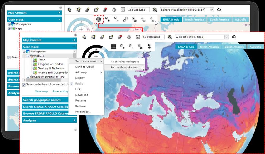
Improved workflow when starting workspace update in Configuration Portal
The workflow for updating the starting workspace in Configuration Portal was enhanced to be simpler and
more intuitive for administrators. Before, administrators had to remove the previous and add a subsequent
map composition to reflect map changes. Now, administrators simply click the Update Workspace button to
apply changes to map compositions that make up the starting workspace.

Arranging the order of the map compositions in the starting workspace is also easier. Just drag & drop the
maps to change the order within the workspace. Changes are applied immediately and visible after refreshing
the Geospatial Portal - Classic.

11 August 2020                                                                                              26
3D View in Configuration Portal
Administrators can enable 3D map mode in Configuration Portal. 3D maps are previewed before
administrators set them as starting maps on user Portals. Lightning, shadow and underground feature data are
supported in the 3D map preview.

11 August 2020                                                                                           27
New Technology (16.6 Update1)
GeoMedia WebMap

OGC WFS 2.0 conformance
Web Feature Service delivered with GeoMedia WebMap follows the OGC 2.0 International Standard. The
OpenGIS Web Feature Service 2.0 Interface Standard (also ISO 19142) has been implemented for Simple
WFS, Basic WFS, Spatial Filter and Transactional WFS conformance classes.

11 August 2020                                                                                        28
GeoMedia WebMap Mobile

Enhanced offline mode
With Update 1, preparing offline configuration is as simple as enabling the new Offline checkbox in the Edit
work dialog. The offline configuration is prepared automatically and does not require any additional
configuration. If enabled, works can be used in offline mode. There is no need to copy the Geopackage
database to the mobile device and then copy it back to the server anymore. With the enhanced offline mode,
you download the GPKG database that is dynamically generated on the server together with stored media
files. Data in GPKG file(s) comes from WFS and/or WMS services. You can work in offline mode when there is
no internet connection. When the connection is back, you can upload your changes to the server (WFS-T
transaction).

11 August 2020                                                                                           29
In the GeoMedia WebMap Mobile App, the synchronization button is used to download and upload data.

11 August 2020                                                                                       30
Auto-configured primary key
The primary key field is no longer available in the attributes view because the mobile application handles it on
its own. Backward compatibility is maintained, so if you had a primary key defined in the previous
configuration, it will be set in the app.

11 August 2020                                                                                                31
Auto-fill values for different data types
An administrator can provide a value for an attribute so inspectors in the field do not need to provide the value
in the mobile app. In the GeoMedia WebMap Mobile application, attributes with an auto-fill option defined are
displayed but cannot be edited by users. Auto-fill can be defined for the following attribute types:
     • Date
     • Date-time
     • Enumeration
     • Number
     • Text

11 August 2020                                                                                                 32
Default values
To boost fieldwork efficiency for GeoMedia WebMap Mobile app users, the ability to define default attribute
values was implemented in Update 1. The default value is used when there is a need to automatically fill a
form’s field when creating a feature. The defined default value will always appear to the user in the form but
can always be changed.
For administrators, setting up the default value is as simple as enabling the Default value checkbox in the
Configure window for chosen the attribute and providing the value.
For Text type attributes, there are the following default value types to choose from:
• Static text – the text value from the input text will be inserted in the field
• Username – the user's login will be inserted in the field
• Current date – the date of modification will be used
• Current date and time – the date and time of modification will be used
11 August 2020 33Enhanced display of media files GeoMedia WebMap 16.6.1 provides an enhanced display of media files. Media files such as photo, video, audio, signatures, and documents (pdf) gathered with the mobile app can be easily reviewed in GeoMedia (desktop). In Mobile Publisher, to configure the media files for a memo type attribute, just pick the media type from the list in the Display Type column. The URL to the multimedia files is present as a media attribute in GeoMedia Desktop. Simply click the link to open the media. Please note that the Hyperlink option must be enabled for the WFS attribute. 11 August 2020 34
Remote server connection to the mobile backend
With Update 1, there is ability to connect to the mobile backend remotely. An administrator can set the URL to
the Mobile backend server with configurations. Synchronization with the configuration on the remote server is
ensured. You can download the configuration from a connected remote server, and it will overwrite the local
one.

All changes made in the configuration are saved on the provided remote server.
A Mobile Publisher server connection with Windows authentication is also available. For this purpose,
Windows authentication must be enabled in the IIS settings on the Mobile backend side.
A notification appears when permissions are not sufficient. The Mobile Publisher group is used to control
accounts that have permission to access the server.

An administrator assigns users to the group. There is no need to provide any additional information when a
user is logged in and using a domain account.

11 August 2020                                                                                               35
Enabled multiple connections (handling several sources)
Now you can make configurations with legend entries from different connections. Supported data sources
include not only WFS and Geopackage, but also WMS and WMTS. Configure legend entries from raster
services (WMS & WMTS). Raster layers can be used instead of a base map. WMS and WMTS legend entries
are read-only (there is no ability to create, delete, and update features in GeoMedia WebMap Mobile). Feature
Info works with WMS layers.

11 August 2020                                                                                            36
Handle multiple map windows and assign works with a map window
The New Map Window combo box in the Edit Work properties dialog was introduced. It lists all open map
windows in GeoMedia (desktop). When adding a new job, the default active map window is chosen. You can
change the map window that will be used with the mobile configuration. The legend entries listed in Mobile
Publisher will be refreshed based on the currently selected map window. The map window is connected with
the work, so once the work is created and saved, the map window cannot be changed.

11 August 2020                                                                                           37
Use map window bounding box (BBOX) as a default
The same starting BBOX is set in GeoMedia WebMap Mobile app as defined in the GeoMedia desktop Map
window for the corresponding configuration. Zones are superior, which means that if a zone is defined in the
configuration, the map view will be adjusted to the zone area for the user.

11 August 2020                                                                                                 38
Quick start guide in Mobile Publisher
Key settings must be configured in the GeoWorkspace before defining works. The quick start guide is a new
feature that makes configuration even simpler. The user-friendly quick start guide will appear when the
workspace has any needed setting unconfigured, such as the proper geoworkspace coordinate system set or
registered data sources; when the active map window with legend entries is not present; or when at least one
user account is not defined for GeoMedia WebMap Mobile. The quick start guide dialog will list the task(s) that
need to be done. Short instructions on how to do it will be also provided. Simply do the steps listed in the quick
start guide dialog before you start to define works.

11 August 2020                                                                                                 39
Picture style support for the point feature class
Point feature class can have the picture style defined. The picture style for points can be used irrespective of
configuration mode, online or offline. In addition, static and dynamic picture rotation is supported also for both
online and offline configuration modes.

11 August 2020                                                                                                  40
Honoring WFS/WMS legend entries locatability in GeoMedia WebMap Mobile
The legend entry locatability setting in GeoMedia desktop is directly mapped with the layer locatability in the
GeoMedia WebMap Mobile application. Setting a given WFS feature class or WMS layer’s Locatable option to
Off will prevent the possibility of clicking on the same layer in the GeoMedia Mobile application. To change the
legend entry locatability setting in the GeoMedia WebMap Mobile app, just set the Locatable option to the
desired state (On/Off) in the GeoMedia legend and then overwrite the configuration in the GeoMedia WebMap
Mobile Publisher.

11 August 2020                                                                                               41
New base maps (Here Maps/Bing Maps)
A base map pull-down list (in Edit Work dialog) is now enabled for a work. You can pick from several base
maps:
    • Open Street Map
    • Bing Maps
    • Here Maps

You can also refrain from using any base map – just select “none” from the list.
Click the Options button to define more options and provide information that is needed by the API.

11 August 2020                                                                                              42
Display of GPS accuracy in GeoMedia WebMap Mobile app A new feature in GeoMedia WebMap Mobile displays the most recent device request GPS accuracy value in bottom-right corner of the application screen, using the preferred system of units. Presented values are rounded to one decimal place and units depend on GPS antenna strength. For example, the m/yd/ft will change into cm/in while obtaining signal from better equipment than a built-in cell phone GPS module. Displayed is the value from the most recent device request and updates depending on the location mode selected. This feature makes it possible to combing the software with Leica devices. GPS accuracy is also visible while editing and inserting new features. The GPS accuracy view can be disabled globally in the app settings. 11 August 2020 43
Geospatial Portal and Consumer

New print engine support in Geospatial Portal
Starting with Geospatial Portal version 16.6.1, it is possible to configure a Chrome print engine. You can print
maps using Internet Explorer, phantomJS, and Chrome (new). The engine definition is stored in the
WebConfig file for the Portal instance and requires only two parameters: the type of engine and the path to the
executable file.
    Sample:

Ability to connect to secured WFSG services in Geospatial Portal
Update 1 gives you the benefit of registering an authorization-protected WFS-G service. In the New Data
Source window for the WFS-G connector, a new key button has been added. This key button opens a
registration form to provide credentials for the WFS-G service. After registering a secured WFS-G service, the
Geospatial Portal search engine works as it used to.

11 August 2020                                                                                               44
Search for coordinates in Consumer Portal The Geospatial Portal - Consumer with Update 1 installed gives you the ability to search for geographical coordinates. The built-in coordinate search allows users to type coordinates in Decimal Degrees format (DD.ddddd, e.g. 51.23456 21.78654) or Degrees, Minutes, Decimal Seconds (DMS, e.g.51° 14' 4.42" N 21° 47' 11.54" E). The coordinate separator can be a space or comma. To determine the direction, you can provide cardinals or type a minus character for West and South (e.g. 34.23456S 61.78654W or -34.23456 -61.78654). When coordinates are found, a pin showing the location on the map is displayed. 11 August 2020 45
Improved Consumer Portal UI
We've added some improvements to the portal UI that make working with the Consumer Portal more intuitive.

Disable unavailable elements (Search, Go to my location)
Firstly, features that are not configured are not displayed on the Consumer Portal screen. This applies to the
Go to my location and Search features.
The Go to my location feature in Consumer Portal works only with secured (https://) connections. When a
Consumer Portal instance is configured over a non-secured connection, the Locate Me button and the Show
my location options on the Settings panel will not be displayed, and the features will not be available.
The same mechanism applies for Search bar. If no search engine is configured for Consumer Portal, then the
search controls are not displayed for users.

11 August 2020                                                                                              46
Secondly, an administrator can adjust the Consumer Portal to the users’ needs. With the new Appearance tab
in the Administration Console, the following display options can be enabled or disabled:
• Show Map Info
• Show Scale Bar
• Collapse Legend Group

11 August 2020                                                                                         47
Map Info provides a set of information about the active map:
•   Geographic latitude and longitude for the current cursor position in a map window
•   The name of active Map Composition
•   The coordinate system EPSG code of the current map

Map info is displayed in the bottom right corner on the screen application.

Scale bar provides approximate information about the scale and distance on the map.

11 August 2020                                                                          48
The Collapse Legend Entry setting allows users to decide whether all layers in the Consumer Portal Legend
should be collapsed on start or not. If enabled, all groups in the Consumer Portal Legend are collapsed when
Consumer Portal starts. This is especially useful when multiple map layers from several data sources are in
the workspace and as an administrator you do not want to show them all when the user runs Consumer Portal.

Preserve legend settings between Map Composition switches
Further improvements for Consumer Portal include a memory for legend changes during one session. When a
user adjusts layer properties (layer display on/off, transparency, layer order), switches the Map Composition,
and displays the previous Map Composition again, all layer settings will be the same as set before.

11 August 2020                                                                                              49
Base maps in Consumer Portal
The new base map feature provides a background of geographical context for the content displayed within a
Map Composition. Users can change the base map of the current Map Composition at any time using the base
map switcher. The base maps available in the current Consumer Portal instance are prepared by the
administrator.
The process of creating base maps with Configuration Portal is quick and easy. Just select the Consumer
Base Map option for the map composition(s) in the workspace prepared and send the workspace to the
chosen Consumer Portal instance. Maps with the Consumer Base Map option enabled will be translated into
the workspace as the base maps and will not be included in Map Compositions. This means the layers
included in them will not be visible in the legend.

The base map thumbnails for the base map selector in the Consumer Portal GUI are generated automatically
based on the Map Composition thumbnails defined for the Consumer Portal instance.

11 August 2020                                                                                        50
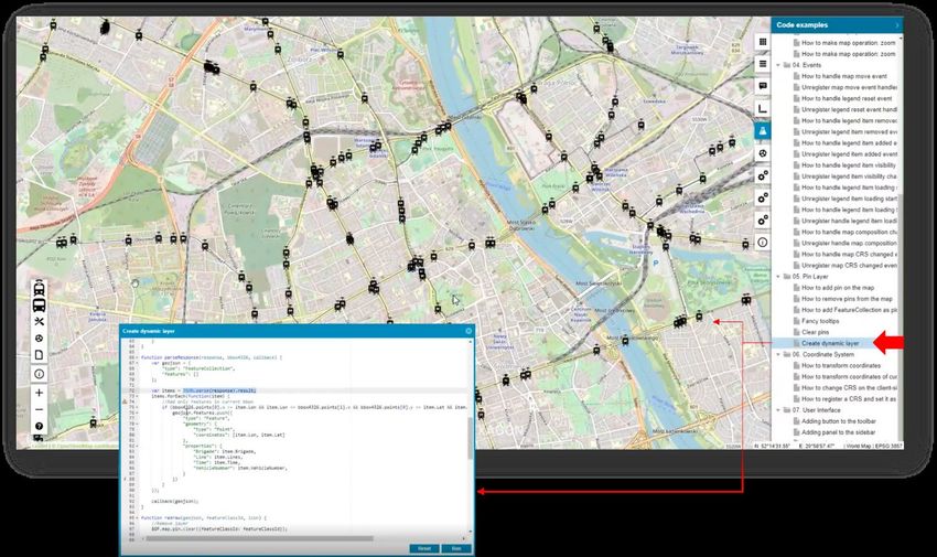
Using Consumer Portal SDK - dynamically refreshed content
Last but not least, improvement was introduced for the Consumer Portal SDK. Now Consumer Portal supports
dynamically refreshed content so you can observe objects moving on the map in real time (e.g. public
transport, railway, metro, buses, planes, etc.). Dynamically refreshed content is based on third-party API
services. An SDK example showing how to implement dynamic layers has been introduced and can be used to
enhance Consumer Portal capabilities with a layer of data updated online.
In short, from a technical point of view, the response from the custom API format is parsed to the JSON format
and all features are collected within the current bounding box and then displayed on the map. The layer is
refreshed by the time set.

Moreover, each dynamically displayed feature on the map has a tooltip with additional information. The tooltip
is displayed when the user clicks on the feature.

11 August 2020                                                                                              51
System Requirements
GeoMedia WebMap

                 •     Windows Server 2019 (64-bit)

                 •     Windows Server 2016 (64-bit)
Operating     NOTES:
Systems
                 •     All later service packs are considered viable unless otherwise noted. See the Support
                       website for specific notices.

                 •     On the Client side, (Geospatial Portal and/or GeoMedia WebMap Publisher Portal) any
                       operating system equipped with one of the supported browsers.

Operating        •     iOS version 12.x or later
Systems for
GeoMedia         •     Android version 5 or later
WebMap
Mobile           •     Windows 10

                 •     Oracle® Server 12.2 (64-bit)
                 •     Oracle® Server 12.1 (64-bit)
                 •     Oracle Server 11g (64-bit) (at least 11.2.0.4)
                 •     Oracle Server 11g (32-bit)
                 •     Oracle Express 11 g (at least 11.2.0.4)
                 •     Oracle Client 12.2 (32-bit)
                 •     Oracle Client 12.1 (32-bit)
                 •     Oracle Client 11g (32-bit)
                 •     SQL Server® 2012 (64-bit)
                 •     SQL Server 2014 (64-bit)
                 •     SQL Server Express 2012
Server Side      •     SQL Server Express 2014
Database         •     SQL Server 2016
Engines          •     SQL Server Express 2016
                 •     SQL Server 2017
                 •     SQL Server Express 2017
                 •     PostgreSQL 9.3 with PostGIS 2.1
                 •     PostgreSQL 9.4 with PostGIS 2.2
                 •    PostgreSQL 9.6 with PostGIS 2.3
                     Note:
                        •   All later service packs are considered viable unless otherwise noted. See the Support
                            website for specific notices.
                        •   Access (MDB) is considered as viable.
                        •   No Database Engine is required on the client side nor to run the Administration
                            Console.

11 August 2020                                                                                                      52
• Google Chrome™ 77 or higher
• Firefox® 69 or higher
• Internet Explorer® versions 11
• Microsoft Edge 44 or higher
• Safari® 12 or higher
Note:
• For browsers: Firefox and Google Chrome versions stated above are the versions
certifications were conducted on. The software should work on newer versions of these
Client Side browsers but were not officially certified.
Internet
• The 3D features of Geospatial Portal Classic require native WebGL support. WebGL is
Browsers
available in Firefox, Chrome and MS Edge.
(Client is
Geospatial 3D functionality in Geospatial Portal Classic /GeoMedia WebMap Publisher Portal is enabled
Portal & by default in Firefox and Google Chrome browsers. In MS Edge, 3D is available only if the
GeoMedia administrator enables it.
WebMap
Publisher Portal) • Web browser issues found on the GeoMedia WebMap product that are no longer supported
by the browser vendor can be addressed with a limited scope by Hexagon Geospatial. Refer
to vendor sites for information on their Web browsers support policies.
• Geospatial Portal Classic is not supported to work in Compatibility View in Internet Explorer
browsers. This option must be switched off by the user.
• The mobile versions listed as supported web browsers are compatible with GeoMedia
WebMap. However, differences in system architecture and mobile device limitations may
result in some of functionality being unavailable when running on a mobile browser. Hexagon
will attempt to address any mobile browser issues; however, a solution may ultimately
depend on support from the browser provider.
• Internet Explorer versions 11
Note:
Server Side • Internet Explorer is required on the server side only to provide the printing
Internet functionality unless Google Chrome or PhantomJS engine is used.
Browsers • In order to run the Administration Console directly on the server host machine, any
browser listed in Client-Side Internet Browsers can be used. Administration
Console can be run remotely from the client side.
Client Side • GeoMedia or GeoMedia Professional 16.6
System NOTE:
Dependencies
& Additional • GeoMedia or GeoMedia Professional is required for GeoMedia WebMap Publisher
Software Administrator.
Server Side • .NET Framework 4.7.2
System • Microsoft Identity Foundation
Dependencies
• Windows Installer 3.1 or higher
& Additional
Software • Internet Information Services (IIS) 10.0
11 August 2020 53Geospatial Portal
• Windows Server 2019 (64-bit)
Server Side
• Windows Server 2016 (64-bit)
Operating
Systems
• Oracle Server 12.2 (64-bit)
• Oracle Server 12.1 (64-bit)
• Oracle Server 11g (64-bit)
Database • Oracle Client 12.2 (32-bit)
Engines • Oracle Client 12.1 (32-bit)
• Oracle Client 11g (32-bit)
• Oracle Express 11 g
• Google Chrome 77 or higher
• Firefox 69 or higher
• Internet Explorer version 11
• Microsoft Edge 44 or higher
• Safari® 10 or higher
Notes:
• For browsers: Firefox and Google Chrome version stated is the version that
certification was conducted on. The software is expected to work on newer versions
of these browsers, but they were not officially certified.
• The 3D features of Geospatial Portal require native WebGL support. WebGL is
available in MS Edge, Firefox and Chrome.
Client Side
Internet • The 3D functionality in Geospatial Portal Classic /GeoMedia WebMap Publisher
Browsers Portal is enabled by default in Firefox and Google Chrome browsers. In Microsoft
Edge, 3D capabilities are only available if enabled by the administrator.
• Web browser issues found on the Geospatial Portal Classic product that are no
longer supported by the browser vendor can be addressed with a limited scope by
Hexagon Geospatial. Refer to vendor sites for information on their Web browsers
support policies.
The mobile versions listed as supported web browsers are compatible with GeoMedia
WebMap. However, differences in system architecture and mobile device limitations may
result in some of functionality being unavailable when running on a mobile browser. Hexagon
will attempt to address any mobile browser issues however a solution may ultimately depend
on support from the browser provider. Note for Internet Explorer:
• Geospatial Portal does not work in Compatibility View in Internet Explorer browsers
- this option must be switched off by the user.
• Internet Explorer versions 11
Note:
Server Side • Internet Explorer is required on the server side only to provide the printing
Internet functionality unless Google Chrome or PhantomJS engine is used.
Browsers • In order to run the Administration Console directly on the server host machine, any
browser listed in Client-Side Internet Browsers can be used. Administration Console
can be run remotely from the client side.
11 August 2020 54Server Side • .NET Framework 4.7.2 or higher
System • Windows Identity Foundation
Dependencies • Windows Installer 3.1 or higher
& Additional • Internet Information Services (IIS) 10.0
Software
Geospatial SDI
• Windows Server 2019 (64-bit)
Operating Systems
• Windows Server 2016 (64-bit)
• Oracle® Server 12.1 (64-bit)
• Oracle® Client 12.1 (32-bit)
• Oracle® Server 11g (64-bit)
• Oracle® Client 11g (32-bit)
• SQL Server® 2008 (32-bit)
• SQL Server® 2008 (64-bit)
• SQL Server® 2008 R2 (32-bit)
• SQL Server® 2008 R2 (64-bit)
• SQL Server® 2012
• SQL Server® 2014
• Access® 2010 (MDAC2010 v14)
Database Engines
Note:
• All later service packs See the Support website for specific notices.
• NHibernate, Log4Net and ADO.NET are used for accessing database in SDI
Pro Security and Logging mechanisms. The full list of supported database
engines depends on these third-party frameworks. However, SDI services
were used successfully with listed engines.
• 64-bit Oracle Data Access Components (ODAC) is required for Catalogue
(CSW) services running with Oracle Server 12 (64-bit)
• Google Chrome 77 or higher
• Firefox 69 or higher
• Internet Explorer versions 11
• Microsoft Edge 44 or higher
Internet Browsers Note:
(required to run • For browsers: Firefox and Google Chrome version stated is the version that
Administration certification was conducted on. The software is expected to work on newer
Console) versions of these browsers, but they were not officially certified.
• Web browser issues found on the Geospatial SDI product that are no longer
supported by the browser vendor can be addressed with a limited scope by
Hexagon Geospatial. Refer to vendor sites for information on their Web
browsers support policies.
11 August 2020 55• Internet Explorer versions 11
Note:
Server Side • Internet Explorer is required on the server side only to provide the printing
functionality unless Google Chrome or PhantomJS engine is used.
Internet Browsers
• In order to run the Administration Console directly on the server host
machine, any browser listed in Client-Side Internet Browsers can be used.
Administration Console can be run remotely from the client side.
• .NET Framework 4.7.2
• Windows Identity Foundation
• Windows Installer 3.1 or higher
Server Side
• Internet Information Services (IIS) 10.0
System
Dependencies & Note:
Additional Software
• All later service packs for the system dependencies are considered supported
unless otherwise noted. See the support website for specific notices.
11 August 2020 56Issues Resolved (16.6)
Geospatial Server 2020
GeoMedia WebMap, Geospatial SDI, Geospatial Portal
Issue ID Summary
00027335 Disabled fill style displayed on WFS feature in Consumer Portal.
00027348 Scale Bands limiting zoom in Consumer Portal.
00031395 Consumer Portal's layer stacking causes problems if JPEG is used.
00030480 Consumer Portal search issues. Search tool returns search results randomly.
00036826 Measurements lost after placing last point - iOS Chrome Browser.
00029386 Search criteria is not giving any metadata record on registered external OGC
CSW. Advance search is able to give metadata records.
00043474 Request Portal use prefix if declared by capabilities.
00051791 Measure area functionality enables measurement of incorrectly drawn surface
geometry.
00030999 Auto classify button disabled for text fields.
00036041 Performance issues - Portal cluster.
00034738 IIS windows authentication: Consumer and WMS.
00049686 BBOX and URL parameter don't work properly
Geospatial Portal 2018 KVP parameter bbox results in incorrect map extent.
00025080 Cross site scripting vulnerability in security audit of Apollo Portal.
00018235 Error parsing get values string in Geospatial Portal analyses.
00033031 Extrusion issue for WMPS layers in 3D Portal.
00041306 Critical Security Audit Report Jsquery 1.10 has known vulnerability (Apollo 2018
update 4).
00041771 CSW Search for strings containing Diacritics gives no result.
00045933 Wrong coordinate system transformation parameters in CRSConfig_v2.xml.
00022957 CSW Metadata information window show up as text only (not HTML formatted).
00011273 Run-time error '91' when publish GeoMedia workspace to WMS.
00008981 Compiler error with configured STS service.
00014198 Cannot render google map in HTTPS.
00014215 Using predefined query tool changes select set item behaviour.
11 August 2020 5700009877 Portal is not supporting 3-letter language encoding. "Cannot read property
'length' of null".
00042585 GWMPubPro.aspx assigns the value 110 to cookie select Set after running
predefined WMPS query.
00049649 Portal sends invalid CSW request when no filter is specified.
00045356 Annotations not getting printed from User dedicated PSS.
00017531 Unable to add Personal Layer feature class in MapWithToolbar.aspx.
00022650 Poor resolution on texts and symbols on PNG and PDF prints.
00038861 In the Geospatial Portal analyses on WMPS fail.
00028572 Security Vulnerability: CSV Injection.
00043892 PSS features are not returned until Portal page is refreshed.
00026575 WFS – INSPIRE Metadata - Button “Add Spatial Identifier” no responding.
00051504 $GP.dynamicFeatureEvents don't work with WMPS.
00021996 Warnings about CRS84 coordinate system from WMTS service.
00048741 GWM (COM) errors.
00045124 Error in GeoMedia WebMap: Source: Map Server Version: 16.00.0200.00004
Function GetFromLibrary Error: 0x1 Error Description: Not available.
00033551 MapSvr.exe crash - "No known library storage service" Error.
00034187 Correlate OWS and WFS exception codes to HTTP status codes.
00032353 Get Feature Info only works for one WMTS layer.
00011711 ProductDefinition is not OPTIONAL in the WMTS configuration even though it is
defined as such.
00037562 All rules defined in Label Manager written to Generated.lrf
00005788 WMTS - layer title is required for more layers in the service (error when it is not
present).
00039945 Arc geometries are displayed as a straight line in WebMap WMPS (svg/svgz
00029483 format).
00033686 Geospatial Portal 2018 is slower than 2016 when loading WMPS source.
00033348 The line spacing is different than it appears in GeoMedia. Different
Direct2DMode used by GeoMedia (default = 0) and WebMap (default = 1).
00036513 Incorrect ID specified in Label Rule File generated by Publisher Administrator.
00035213 WFS GetFeatureById urn:ogc:def:query:OGC-WFS::GetFeatureById.
00035178 The content type for getFeature, GetPropertyValue and describeFeatureType
should be at least "application/gml+xml; version=3.2" - by default. Also, it should
be able to use this value in the parameter outputformat.
11 August 2020 58You can also read