Towards Collection of Smart City Data for Cloud Storage Using UAVs
←
→
Page content transcription
If your browser does not render page correctly, please read the page content below
Ilia Ageev, Wolfram Hardt                                                                          ESS (Vol 8. No 1. 2021) (pp.4-9)

                                    Issue Topic: “Intelligent Approaches for Smart Cities“

                  Towards Collection of Smart City Data
                     for Cloud Storage Using UAVs
                         Ilia Ageev                                                          Wolfram Hardt
         Yuri Gagarin State Technical University of Saratov                         University of Technology Chemnitz
Institute of Applied Information Technologies and Communication                    Professorship of Computer Engineering
                      E-mail: aliar@yandex.ru                                         E-mail: hardt@cs.tu-chemnitz.de

    Abstract — Developing towards smart cities requires a well-      a high-resolution camera for inspection of buildings. With
developed infrastructure that is lacking in most cities today. Due   these drones, information could be collected and provided to a
to its low cost and flexibility in performing various operations,    cloud system, the TUC DriveCloud.
UAVs can help such cities develop in this direction. The article
describes the methodology and process of collecting smart city                             II. BACKGROUND
data using drones for cities that do not have a sufficiently
developed infrastructure. For storage and subsequent analysis of     A. UAVs
data, a cloud server is required; TUC DriveCloud is presented as
an example of such a server in the article. Traffic analysis and              Drones are usually small airborne vehicles that can
building inspection are described as examples of drone data          carry a variety of sensors and loads [2]. Usually, it operates
collection tasks. The advantages and disadvantages of collecting     remotely by an operator or autonomously by onboard
data using a thermal imaging camera are also discussed using the     computers. The drones are easy to use, have a wide range of
example of the problem of detecting and tracking the movement        sophisticated missions, support high-definition video
of people.                                                           recording, and can cover large and hard-to-reach areas.
                                                                     Moreover, with their development, they are becoming cheaper
    Keywords — UAV, drone, data collection, cloud storage,
                                                                     along with improving the efficiency of operations. This is why
thermal camera.
                                                                     smart cities use drones in a wide variety of applications. There
                                                                     are some drone capabilities applied to smart city [4]:
                      I. INTRODUCTION                                     • Due to the special design, it becomes possible to
          Following the definition of the European                            install various sensors on the drone to perform
Commission, a smart city is ”A smart city is a place where                    various tasks, such as geospatial research and land
traditional networks and services are made more efficient with                management, along with environmental analysis.
the use of digital and telecommunication technologies for the             • Additionally, trends towards data mining are
benefit of its inhabitants and business” [1].                                 allowing drones to be deployed in the civil security
          A smart city describes a city with deep-integrated                  arena. The involvement of drones in smart policing,
automated processes triggered by data from other processes or                 integration with mobile applications, stable and safe
users. Typically, this requires a powerful, interconnected city               wireless networks can help make a smart city a safer
infrastructure to collect and distribute all types of data. It                place. Also, this could allow city governance to shift
includes data collected from people, devices and buildings,                   from being reactive to proactive.
which are then analyzed to control and manage transport,                  • Due to their ability to reach remote locations, drones
energy, security, emergency and other systems to ensure the                   provide the ability to more effectively monitor and
efficient functioning of the city. Up today, for many cities, this            control disasters such as fires, floods, earthquakes,
infrastructure is not available. UAVs (or drones) can help such               and so on.
cities in development towards smart cities due to their low
cost and high flexibility in collection data.                        B. TUC DriveCloud
          Three types of drones will be considered that can                   Cloud storage is one of the requirements that must be
help cities evolve towards smart cities. One drone is equipped       met to integrate smart systems with smart products and
with a thermal camera, the second drone with a high-                 services in the context of a smart city. Cloud storage stores
resolution camera for traffic analysis, and the third drone with

                                                                  ~4~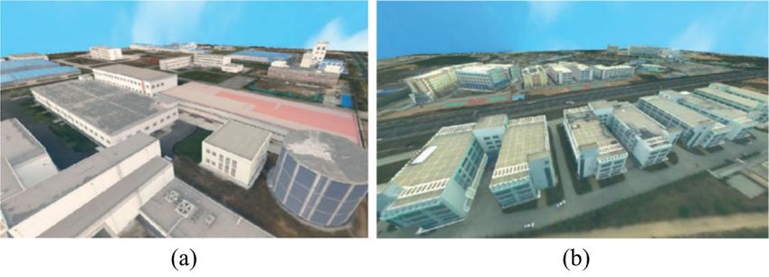
Ilia Ageev, Wolfram Hardt                                                                          ESS (Vol 8. No 1. 2021) (pp.4-9)

data and statistics that are analyzed and processed to make                            III. DATA COLLECTION
sense over time and be used for decision making [3].
         TUC DriveCloud is a big cloud data storage and             A. UAV Mission Framework
analysis platform mainly targeted at but not limited to                       The whole drone mission management process can be
automotive test applications [5]. It can be used with any type      presented as a framework. The framework divides the entire
of vehicles, including drones.                                      process into a set of steps, which leads to the systematic and
         Its main features are structured sensor and vehicle        efficient conduct of any research using drones. The core of the
management; standardized input and output API (abstracted           framework is existing research. It is divided into the following
from the actual storage technology); support for test drive         components [8]:
management and recording as well as a live preview of                    • Scope definition. The first module of the framework
collected data, and labeling of test drives.                                  contains the definition of the scope of the study. It is
         The TUC DriveCloud system is a structured cloud                      the most important step, as all subsequent steps
database for recording and administering data obtained from                   depend on it.
sensors. This cloud-based database can be accessed with                  • Flight planning. The Flight Planning Stage includes
drones using standardized APIs for input and output as shown                  preparing to launch the drone to collect the necessary
in Figure 1. Currently, there is no such connection.                          data.
                                                                         • Flight implementation. During the flight of the drone,
                                                                              the drone flies over the area of interest along the
                                                                              prepared route and collects the necessary data using
                                                                              the sensors located on it. The flight is carried out
                                                                              based on the parameters determined during the
                                                                              previous step. The flight, depending on the
                                                                              preference and experience of the drone user, is
                                                                              controlled manually using the radio remote control or
                                                                              using the autopilot function.
                                                                         • Data acquisition. The collection of information is
                                                                              highly dependent on the scope of the study. The data
                                                                              includes high-quality video recording along with
                                                                              other data from sensors located on the drone. In some
                                                                              cases, flight telemetry data is also collected from the
                                                                              drone and used to calibrate the recorded video.
                                                                         • Data preprocessing and transferring. After collection,
                                                                              data from the drone should be preprocessed and
                                                                              transferred to the server for further processing.
                                                                         • Data processing and analysis. Video analytics has
                                                                              attracted considerable attention mainly because of the
                                                                              ability to easily visualize a phenomenon along with
                                                                              detailed trajectory data at the same time [9].
                                                                         • Data        interpretation.     Data    interpretation   is
             Figure 1: TUC DriveCloud Platform.                               implemented using various visualization tools, such
                                                                              as charts and graphs, which are obtained as a result of
          Another part of the cloud application is a website that             performing data analysis procedures.
runs on the TU Chemnitz PROWeb server and provides a                          The data collection part in this framework includes
simplified user interface for cloud data input and output. Test     all steps up to and including data transferring. These will be
vehicles can be added to the cloud through this web                 described later in the paper.
interface [6].
          TUC DriveCloud allows to set the sensor readout           B. Flight Planning
period. After this configuration, the vehicle can conduct trips,              Due to the significant increase in the number of
the data of which will be stored in the cloud database, sorted      drones, laws began to be developed and enforced to regulate
by trips. Data can be saved directly to the cloud database          their use. In such a situation, when collecting data, even more
while traveling through the token-protected API. If this is not     importance is given to planning the flight of the drone. The
possible due to the lack of an Internet connection, the data is     entire planning process can be divided into 3 main aspects:
first saved locally and then loaded into TUC DriveCloud. Trip       safety, environment, and route planning categories.
data, which can be tabulated, can be saved as a CSV file that                 First of all, the survey area for the flight should be
can be uploaded to the cloud database via the website. The          estimated using local maps of the flight areas. Flight
data is prepared graphically and can then be evaluated and          parameters should be selected based on suitable flight zones,
viewed on the website [7].

                                                                ~5~
Ilia Ageev, Wolfram Hardt                                                                         ESS (Vol 8. No 1. 2021) (pp.4-9)

safe thresholds, and other design characteristics. It is followed            Some drone operations can be modeled as path
by obtaining a flight permit from the concerned institution.        planning problems with neighborhoods. This path problem
          Location characteristics such as infrastructure must      consists of finding the shortest path length for one or more
also be considered to determine optimal flight parameters.          drones so that each neighborhood must be visited at least once.
Parameters such as weather, wind, and time of day at the study
site require special consideration.
          With the advancement of technology, more and more
advanced drone route planning technologies are available to
develop more methodical and automated operations. Using
such tools, the user can easily indicate the points in the
planned route that the drone should visit. Alternatively, it is
possible to upload a precise path to the drone for automatic
flight.
          There are many civilian drone applications and route
planning problems associated with them. These problems can
be classified by the type of drone operation [11]:
     • Area coverage, where drones have to cover a certain
          area,
     • Search operations, where drones have to find static or
          moving objects,
     • Routing for a set of locations, where drones have to         Figure 2: Drone tours example [11]. (a) is a Dubins tour, (b) is
          visit a set of locations,                                 a tour in routing with neighborhoods, and (c) is a tour in case
     • Data gathering and recharging in a wireless sensor                                of dynamic requests.
          network, where drones have to acquire data from a
                                                                              During disaster management, such as oil spills, forest
          set of addresses with considering constraints of
                                                                    fires, earthquakes, or urgent services such as traffic accident
          memory storage and communication network,
                                                                    investigations, surveillance requests are dynamic and must be
     • Allocating communication links and computing
                                                                    handled by available drones. Since the execution time of such
          power to mobile devices, where drones are located to
                                                                    queries is often undefined, various variants of the dynamic
          ensure a certain quality of communication with
                                                                    traveling repairman problem can arise. Traffic information is
          mobile devices,
                                                                    an important part of smart city management. Such systems as
     • Operational aspects of a self-organizing network of          traffic monitoring and control, public transport planning, and
          drones.                                                   so on are based on it. However, static traffic sensors are not
C. Traffic Analysis                                                 installed everywhere due to their high purchase and
           Traffic affects the life of every citizen in several     maintenance costs. Also, mobile traffic detectors are not
aspects: the time it takes to move from home to work, the           widespread, resulting in the low acquisition of traffic
quality of the air he/she breathes, the stress caused by being      information. Thus, drones, as a new tool, have their unique
stuck in traffic jams, as well as lack of sleep and exercise as a   advantages in mobility, versatility, wide camera viewing
result of time spent in traffic jams [10]. Thus, an important       angles, and low operating costs.
part of a smart city is the monitoring and management of                      Consider an existing traffic analysis framework. It
traffic in the city.                                                has the following five components [12]: motion analysis;
           In some surveillance applications, such as               SVM (support vector machine) based vehicle detection;
transportation planning, routing is done using area coverage.       motion-vector clustering; connected counting, and traffic flow
However, the most common use of these applications is a tour        parameter estimation.
of multiple points or road segments, starting and ending at a                 Further processing allows you to collect traffic flow
depot. Thus, this planning problem can be formulated as a           data from frame-based information. Vehicle speed and traffic
generalized version of such common problems as traveling            density are the most valuable parameters for simulating a
salesman problems or vehicle route problems [11].                   traffic model.
           There are several varieties of drone path planning       D. Building Inspection
problems. Some of the most common problems are presented                    3D visualization is becoming an important
in Figure 2.                                                        component of a smart city, making it more accessible to more
           One of the factors influencing route planning is the     people. Smart 3D city models are being developed by cities
presence of a minimum turning radius for drones traveling at a      such as Hamburg, Helsinki, Chicago and London to simplify
constant speed. The path of such drones, which cannot contain       city master planning and assess the impact of new
bends with a radius less than a certain value, is called a Dubins   developments and public services.
path.

                                                                ~6~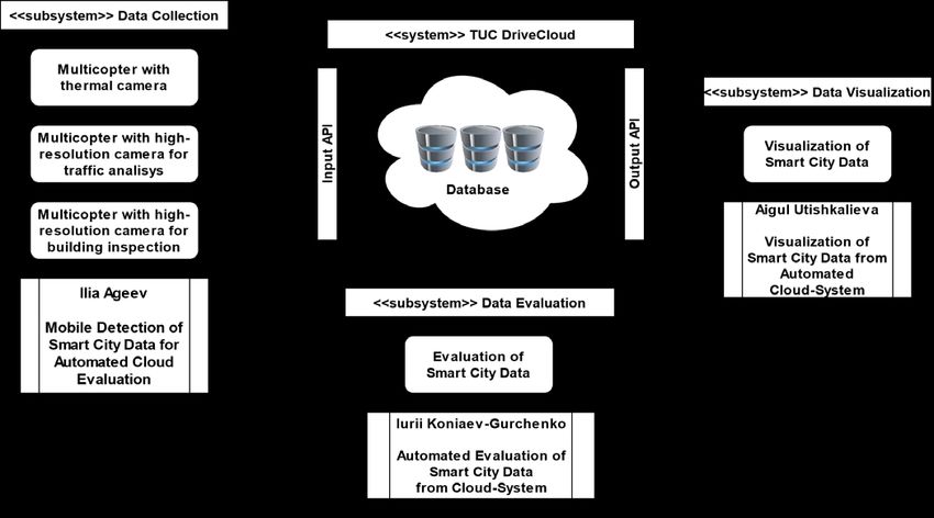
Ilia Ageev, Wolfram Hardt ESS (Vol 8. No 1. 2021) (pp.4-9)
A building inspection uses the area coverage route
planning or less often the routing for a set of locations.
Coverage path planning refers to finding a path for a
drone in which all points of a certain area are covered at least
once. [11].
Figure 3 shows examples of drone paths. The
common trajectories are spiraling and lawn mowing patterns.
An area can also be represented as a graph by dividing the
area into a collection of cells. Next, it is needed to capture
information about the connectivity of these cells and the
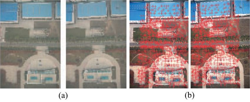
Figure 4: Image overlap example [13]. (a) are original images
distance between them. If we represent these cells as the
and (b) are images with conjugate points.
vertices of a graph, this reduces the task of building a route to
a travelling salesman problem (TSP). A 3D city model is one of the most important
photogrammetric products. It finds applications in many areas
such as vehicle navigation, online shopping, city planning, and
so on. Low-altitude drone imagery of the city helps make
these models more detailed with improved textures due to
their image overlap characteristics. An example of such a 3D
model is in Figure 5.
Figure 5: 3D city model example [13]. (a) are industrial
buildings and (b) are residential buildings.
Figure 3: Path patterns example [11]. (a) is a lawn mowing
pattern, (b) is a spiral pattern, and (c) is a representation as a E. Thermal Camera
graph.
Thermal cameras can be used in many fields. One of
When constructing a route, it is worth taking into the most popular applications for thermal cameras is building
account the height differences of the territory, as this affects inspection. However, due to the reduction in cost and
the energy efficiency of the routes. The data collected with the independence from lighting, they are becoming popular in
drone can be converted into a 3D model for further analysis. various fields. For example, they can be useful in border and
For this, the following existing framework is used [13]: image coastal surveillance as they can spot people several kilometers
acquisition; image matching; relative orientation; bundle away. They resemble color cameras in weight and size,
adjustment; DSM and DOM generation, and 3D building although they are still more expensive [14]. A network of such
reconstruction. cameras can become part of a larger network of cameras due
The photogrammetric processing, including image to the ease of data transfer [15].
matching, the relative orientation of images, bundle The main application of such cameras for a smart city
adjustment, generation of the digital surface model (DSM) and is their use to detect and track the movement of people [16].
the digital orthophoto map (DOM), and building An example of this use can be seen in Figure 6. When
reconstruction in the 3D model are the steps to build 3D subtracting the background to detect moving objects, the
models. disadvantages of both types of cameras must be considered.
Photos taken from drones with digital cameras have To use RGB cameras, it is worth considering the shadows of
very important advantages for matching images and people, which can quickly change depending on the lighting
generating a 3D model of buildings. The main ones are the and cause false detection. When using a thermal camera, it is
wide-angle view of the camera and the high area of overlap, worth considering reflective surfaces as they are capable of
which can be up to 80%, which means that an area will appear reflecting thermal radiation that can be captured by the
in 5 different shots. It allows the design of models with high thermal camera. A comparison of camera types is shown in
precision. Figure 4 shows example of overlap detection. Table I.
~7~Ilia Ageev, Wolfram Hardt ESS (Vol 8. No 1. 2021) (pp.4-9)
it is necessary to consider the network bandwidth and, thus,
design the drone routes depending on the network coverage
area. If the speed of the Internet connection is not sufficient to
transfer original photos or if the space in the cloud storage is
limited, the frames must be compressed before transfer. It
happens at the preprocessing stage. If the data transfer takes
place offline, then, during the flight, the drone saves all data to
a hard drive and transmits the data during its return to base. In
this case, there is no need to consider the connection speed,
but besides, the size of the drone storage must be considered.
Figure 6: Using thermal camera for people segmentation [17].
(a) is thermal image input and (b) is automatic segmentation. IV. SOLUTION
A. Shared system
TABLE I. COMPARATION OF RGB AND THERMAL CAMERAS FOR PEOPLE
DETECTION [17] All of the above examples of using a drone to collect data can
be used in the context of a smart city. To do this, it is
Advantage Disadvantage necessary to transfer the collected data to the TUС DriveCloud
Easier segmentation
Identification difficult cloud storage.
Independent of light The proposed system for collecting data from a drone is part
Thermal More expensive
No privacy issues
Single channel images
Reflections of the pipeline of a project for collecting, processing and
Sensitive to light visualizing data from a smart city. The general system
Cheap sensors
RGB
Identification possible
Privacy issues diagram is shown in Fig. 8.
Shadows
F. Data Transferring
The last step in collecting data is sending the data to
the server for further processing. The transmission takes place
frame by frame or as a video stream using a special Access-
Point module installed on the drone.
To access the TUC DriveCloud server, the
standardized REST API and HTTP protocol are used. Figure 7
shows components of drone and server communication.
Figure 8: General system diagram
B. Data collection part
Data collection is the first part of the project. To implement
the ability to transfer data from drones to the TUC DriveCloud
server, it is necessary to develop and implement a data transfer
module for drones. Such a module will collect data from
drones using the MAVLink protocol and transmit data via the
Internet using HTTP requests. The collected data will be the
image from the camera installed on it, as well as telemetry
data, such as location, altitude, speed and direction of flight.
The proposed data flow diagram of the module is shown in
Fig. 9.
The module collects telemetry data from the drone directly
using the Mavlink Abstraction component. This is an already
Figure 7: Scheme of a drone data transferring [18] implemented component that allows you to work with the
MAVLink protocol using software interfaces.
During a mission, the drone transmits not only data During the flight, the drone records video, which is saved
from wearable sensors, but also, if necessary, some telemetry, locally in a video file. Video Frame Reader component allows
such as altitude, speed, and coordinates. you to extract the last captured frames from the recorded video
When transmitting data online, the data is sent from and save them to the file system as a separate file, passing the
the drone in real-time. When using this transmission method, path to this file to the module. Using this path, the module can
~8~Ilia Ageev, Wolfram Hardt ESS (Vol 8. No 1. 2021) (pp.4-9)
find this file and extract all the data necessary for sending [4] Zhang, Y., C. Dragga, A.C. Arpaci-Dusseau, and R.H. Arpaci-
Dusseau, “ViewBox: Integrating local file systems with cloud
from it, including the image itself. After the module has all the storage services”, FAST, 2014, pp. 119-132.
necessary data, it converts them into TUС DriveCloud- [5] Muhlmann, I., “Generische anbindung von testfahrtdatenquellen
specific requests and sends them to the server for further an ein automotive-cloudsystem”, Bachelor Thesis, TU Chemnitz,
processing and storage. 2019.
[6] Englisch, N., Bergelt, R. and Hardt, W., “An Educational
Platform for Automotive Software Development and Test”,
IEEE 32nd Conference on Software Engineering Education and
Training (CSEE&T), 2020, pp. 1-4.
[7] Bergelt, R. and Englisch N., “Towards Cloud-supported
Automotive Software Development and Test”, Journal of
Embedded Selforganising Systems (ESS), Vol.2, Iss.2, 2020,
pp. 8-12.
[8] Khan, M.A., Ectors, W., Bellemans, T., Janssens, D., Wets, G.,
“UAV-based traffic analysis: A universal guiding framework
based on literature survey”, Transportation Research Procedia
22, 2017, pp. 541–550.
[9] Barmpounakis, E.N., Vlahogianni, E.I. and Golias, J.C.,
“Extracting kinematic characteristics from unmanned aerial
vehicles”, Transportation Research Board 95th Annual Meeting,
2016.
[10] Bachechi, C. and Po, L., “Traffic analysis in a smart city”.
IEEE/WIC/ACM International Conference on Web Intelligence-
Companion Volume, 2019, pp. 275-282.
[11] Otto, A., Agatz, N., Campbell, J., Golden, B. and Pesch, E.,
“Optimization approaches for civil applications of unmanned
aerial vehicles (UAVs) or aerial drones: A survey”, Networks,
72(4), 2018, pp.411-458.
[12] Najiya, K.V., Archana, M., “UAV video processing for traffic
surveillance with enhanced vehicle detection”, Second
Figure 9: Proposed module dataflow International Conference on Inventive Communication and
Computational Technologies (ICICCT), 2018, pp. 662–668.
[13] Duque, L., Seo, J. and Wacker, J., “Synthesis of unmanned
V. CONCLUSION aerial vehicle applications for infrastructures”, Journal of
Performance of Constructed Facilities, 32(4), 2018,
The general principles of the data collection process p. 04018046.
for a smart city were reviewed in this paper. The possibilities [14] AXIS Communications, “Axis IP surveillance”, 2013.
and disadvantages of using drones for collecting information, [15] AXIS Communications, “Axis network cameras”, 2013.
the stage of preparing the flight, preparing and sending data to [16] Al-Mutib, K., Emaduddin, M., Alsulaiman, M., Ramdane, H.,
the cloud server were considered in detail. Application areas Mattar, E., “Motion periodicity based pedestrian detection and
particle filter based pedestrian tracking using stereo vision
of mobile data collection such as traffic analysis and building camera”, 2012 19th International Conference on Mechatronics
inspection were also explored, along with comparisons and Machine Vision in Practice (M2VIP), 2012, pp. 32–37.
between the use of RGB and thermal cameras for motion [17] Gade, R., Moeslund, T.B., Nielsen, S.Z., Skov-Petersen, H.,
detection. Software has been proposed in the form of a drone Andersen, H.J., Basselbjerg, K., Dam, H.T., Jensen, O.B.,
module for transferring smart city data to a cloud server. Jørgensen, A., Lahrmann, H. and Madsen, T.K.O., “Thermal
imaging systems for real-time applications in smart cities”,
From the given data it follows that cities should International Journal of Computer Applications in Technology,
invest more in researching and deploying drone systems to 53(4), 2016, pp. 291-308.
analyze and manage city operations and processes. The [18] Wiredcraft, “Make your personal drone fly even farther with a
researched articles show that it is currently one of the cheapest 4g network connection”, Accessed June 06. 2021. Available
online at https://wiredcraft.com/blog/drone-copter-uav-4g-
and most versatile methods for getting closer to a smart city network.
due to its advantages.
REFERENCES
[1] European Commission, “Smart cities”, Accessed June 06. 2021.
Available online at https://ec.europa.eu/info/eu-regional-and-
urban-development/topics/cities-and-urban-development/city-
initiatives/smart-cities_en.
[2] Tice, B.P., “Unmanned aerial vehicles: The force multiplier of
the 1990s”, Airpower Journal, 5(1), 1991, pp.41-55.
[3] Mohammed, F., Idries, A., Mohamed, N., Al-Jaroodi, J. and
Jawhar, I., “UAVs for smart cities: Opportunities and
challenges”, International Conference on Unmanned Aircraft
Systems (ICUAS), May 2014, pp. 267-273.
~9~You can also read