TOWARDS IMPROVING OPTIMISED SHIP WEATHER ROUTING - Sciendo
←
→
Page content transcription
If your browser does not render page correctly, please read the page content below
POLISH MARITIME RESEARCH 1 (105) 2020 Vol. 27; pp. 60-69
                                                10.2478/pomr-2020-0007

      TOWARDS IMPROVING OPTIMISED SHIP WEATHER ROUTING

Roberto Vettor1
Joanna Szlapczynska 2
Rafal Szlapczynski3
Wojciech Tycholiz4
Carlos Guedes Soares1
1
  Universidade de Lisboa, Lisbon, Portugal
2
  Gdynia Maritime University, Poland
3
  Gdańsk University of Technology, Poland
4
  Navsim Poland, Bolesławiec, Poland
                                                                 ABSTRACT

       The aim of the paper is to outline a project focussing on the development of a new type of ship weather routing solution
       with improved uncertainty handling, through better estimation of ship performance and responses to sea conditions.
       Ensemble forecasting is considered to take into account the uncertainty levels that are typical of operations in a stochastic
       environment. Increased accuracy of weather prediction is achieved through the assimilation of real-time data, measured
       by an on-board monitoring system. The proposed system will allow smooth integration of short-term Decision Support
       Systems for ship handling in dangerous or peculiar situations with long-term Decision Support Systems for weather
       routing. An appropriate user interface is also a critical part of the project and it will be implemented in a commercial
       Electronic Nautical Chart environment. A prototype of the full system will be installed and tested on a commercial
       vessel in regular operations and under real environmental conditions.

       Keywords: weather routing, Decision Support Systems, uncertainty handling, ensemble forecast

                      INTRODUCTION                                         the isochrone method [20], proposed for manual usage,
                                                                           based on geometrically determined and recursively defined
    Improving safety and navigation performance is a prime                 time fronts (isochrones). Computer implementations of
challenge in the current global economic scenario and this                 the method have been developed over the years (e.g. [14]).
strongly relies on the ability of the shipping industry to                 The isochrone method has a single-objective and, therefore,
efficiently move feedstocks and goods. Increased attention                 limited possibilities for handling dynamic constraints.
to seakeeping, since the early stages of design, has resulted              The other approaches to WR include dynamic programming
in encouragingsafety reports and more competitive                          for a grid of points (which was proposed by [26, 56]) and in 3D
transportation [10, 13]. Moreover, the urgent need to reduce               (by [5, 38, 58). Graphic algorithms have also been successfully
emissions has boosted research into advanced methods for                   adopted, typically adopting the A* or Dijkstra algorithm, as
improving a ship’s operational efficiency.                                 presented in [23, 29], for motor-driven vessels, and in [61, 62],
    Ocean-going vessels are required to operate all year                   for sailing vessels.
round, often in weather conditions that are far from                          The importance of accounting for multi-objective solutions
calm. Over the years, a strong research effort has been                    to guarantee an adequate balance between safety and costs
dedicated to the development of techniques for investigating               was raised at an early stage. The issue was initially overcome
the most favourable paths and speed profiles, depending                    by aggregating the objectives to a single criterion (as in [49])
on the expectedweather conditions, in order to efficiently                 or maintaining the most promising solutions encountered
accomplish this. These methods are generally referred to                   during the search process (as proposed in [41]). In recent
as weather routing (WR). The first approach to WR was                      years however, the application of dynamic programming

 60           POLISH MARITIME RESEARCH, No 1/2020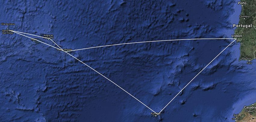
and evolutionary algorithms has become more popular,               smoothly integrated into on-board operations, in order to
allowing the objectives to be kept separated and offering          effectively predict the expected impact on shipping.
a set of favourable solutions, in the form of a Pareto-optimal
set, from which the final route can be selected. A purely
mathematical approach to such optimisation was proposed                   DEALING WITH UNCERTAINTIES
by [15, 24, 43, 53]. Efforts made by the industry to integrate
more advanced route optimisation procedures in the daily               For all weather-routing methods, the main objectives
operations of seafarers are also described in [6, 50]. More        are the optimisation of safety and cost. These factors are
complete reviews of the weather routing methods proposed           related to the ship motions that, besides compromising
in the literature are provided by [7, 33, 40]. The results         safety, may impose voluntary speed reductions and affect
from the various types of weather routing systems showed           the efficiency of the propulsion system, in terms of fuel
that ship traffic has main routes for ocean crossings [51]         consumption and attainable ship speed. On the other hand,
and for coastal navigation [39] but bad weather is avoided         for a given ship, motion and efficiency are strictly related to
whenever it is deemed appropriate [9] and ships deviate            the weather conditions in which it is navigating and, thus, to
from these routes. Thus, the effects of the weather that ships     the uncertainties associated with their prediction. The direct
experience in their lifetime must be incorporated into their       consequence is that a reliable route optimisation primarily
design [54, 55].                                                   requires a trustworthy weather forecast as well as an accurate
   Although remarkable progress has been made, shipping            ship model, in order to be able to assess the behaviour in
is still largely weather-dependent, especially with regards        any given sea-state. While results from classical ship models
to schedule, reliability and control of fuel consumption and       are largely considered as being satisfactory for operational
emissions [12]. One of the main reasons is the stochastic          purposes (particularly with regards to ship motions), this
behaviour of oceanic and atmospheric processes, making             may not be the case for weather forecasting. Even state-of-
the weather forecasts subject to significant uncertainty.          the-art mathematical models are affected by uncertainties
Nowadays, this is in great part due to inaccurate or missing       in the initial conditions.
information regarding the initial conditions, rather than              To cope with this issue, ensemble forecasts are often
numerical limitations. The effect of this is a reduction in        generated[2, 22]. These consist of several runs of the same
the accuracy of the estimation of effects that are affected by     model (or different models in the case of multi-ensemble), each
the predicted weather conditions [27], such as ship motion         with some deviation in the parameters defining the initial
and added resistance.                                              conditions, according to their probability distributions [57].
   The recent ROUTING project was initiated with                   In this way, the output of the forecast can be given in
the objective of overcoming the limitations of the currently       a probabilistic manner, namely the probability distribution
available systems. The project aims to develop a prototype         of the predicted parameters (e.g. the significant wave height)
for a brand-new, on-board solution for ship weather                or, more commonly, the average values and the corresponding
routing which is able to handle the uncertainties from             confidence intervals or standard deviation, the latter typically
weather forecasting during ship voyages and to conduct             increasing with the time-lag of the forecast.
continuous updates of local weather predictions, based on              Uncertainties can also be estimated when ensemble forecasts
the measurements and modelling of sea-ship interactions.           are not available. A recent study conducted by ECMWF [4]
The goal is achieved by taking into account uncertainties          provides a quantitative assessment of the uncertainties from
in the prediction of the sea-states the ship will sail through     different forecast centres. It can be seen that a scatter index
and the adoption of ensemble forecasting, as described             (standard deviation of the error divided by the mean value)
below. Moreover, a complete monitoring system (installed           of below 0.3 is realistic up to five days ahead.
on-board) will allow the collection of information about ship          The ROUTING project aims at dealing with the uncertainties
behaviour and performance in navigation and estimation of          related to weather forecasts in two ways: by continuously
the sea conditions encountered along the route by exploiting       updating the forecast and by assimilating the information
the ship-buoy analogy [16, 31]. The latter will eventually be      relative to the uncertainties in the optimisation procedure,
assimilated in the forecast [17] for a real-time update. Details   thus propagating such information until the evaluation of
on the methodology adopted are described below, including          the objectives and the constraints driving the optimisation.
an overview of the system design, the integration with             For the latter, two different approaches are currently being
commercial ENC-class software and a suitable user interface,       researched, i.e. the “probabilistic approach” and the “ensemble
to facilitate the officers’ interaction with the software.         approach”.
   This new approach is expected to result in a reduction of
long-range ship transportation costs (i.e. fuel consumption),
improved schedule-keeping and improved safety and security         PROBABILISTIC APPROACH
of the crew, cargo and the ship itself. An in-service experience
is planned for the last part of the project, in order to test         Probabilistic methods are typically adopted in the structural
the system under real operational conditions and analyse           reliability analysis of ships [36, 45, 46]. These are used to define
the technical requirements, as well as its capability of being     the safety factors to be used in the Rules of Classification

                                                                     POLISH MARITIME RESEARCH, No 1/2020                          61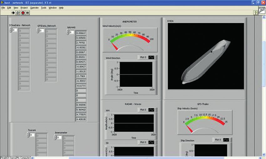
Societies for ship design [11, 19]. Applications to short-term
periods, more compatible with the time interval of ocean
passages, can be found in [45, 47]. With regards to the maritime
industry, risk assessment analysis is often applied to accidents
(for instance, through Bayesian networks [3, 25, 48, 59]) or
Formal Safety Assessment (FSA) approaches [18]. Reliability
analysis is also adopted for the assessment of the probability
of on-board human error.
   A peculiarity of route optimisation is that safety and
efficiency depends on several factors (e.g. roll amplitude,
local accelerations, slamming, propeller racing, etc.) and
so the joint effects have to be estimated [8]. The aim is to
develop a probabilistic risk assessment model for the ship’s
journey that allows for the definition of a reliability index,
based on the probability of all potentially dangerous events
occurring. Following the classical method for evaluating
ship operability [8], a limit state can be defined as the line
                                                                         Fig. 2. Example of the application of the probabilistic operational risk assessment
in the HS–TP graph, above which the ship cannot operate                        method. Black line refers to the maximum allowed Hs and the contour
due to the exceedance of at least one seakeeping criteria                          indicates the probability distribution of the forecasted sea-state
(see Fig. 1). This concept can easily be extended to include
different headings, in which case the limit state assumes
the dimensions of a surface.                                                In Fig. 2, the black line indicates the maximum allowed
                                                                         wave height for the ship to be operable, meaning that all of
                                                                         the seakeeping criteria are respected, while the contour shows
                                                                         an estimation of the probability distribution of the predicted
                                                                         sea-state, assuming a Gaussian probability density function.
                                                                         The risk coefficient that reflects the probability of failure
                                                                         (when the ship will be operating above the maximum allowed
                                                                         significant wave height) is represented by the portion of
                                                                         the contour above the black line and can be calculated as:

                                                                                                                                                   (1)

                                                                         where r i is the risk coefficient in the specific navigation
                                                                         location and f(HS , TP)represents the standard bivariate
                                                                         normal distribution. In the examples above, HS and TP have
                                                                         been considered independently, for simplicity, however,
                                                                         a correlation coefficient can be estimated from weather
                                                                         databases.
                                                                            The above considerations are valid for a specific navigation
                                                                         location or a short track, in which weather and sailing
                                                                         conditions can be considered to be stationary. To extend
                                                                         the results to the whole route, a long-term probability of
                                                                         failure can be calculated as:

      Fig. 1. Example of the maximum allowed wave height for different                                 Rr = Σi f(li)ri                                  (2)
                        seakeeping criteria (from [8])

                                                                         where Rr is the risk coefficient for the proposed route and
   Contrary to traditional methods, and because weather                  f(li) is the probability of the ship sailing on the specific track,
conditions cannot be deterministically estimated, the sea-               which can be calculated as:
state (described by the HS , TP duplet in Fig. 1) that the ship
will face will be represented by a point and contours of                                                                            (3)
decreasing probabilities will be centred on the mean forecasted
conditions. An example is given for a forecasted sea-state in            where di is the time required to sail the ith track and dr is
Fig. 2, where HS = 3 m and TP = 6 s, with standard deviations            the duration of the voyage.
of 0.4 m and 0.1 s, respectively.

 62            POLISH MARITIME RESEARCH, No 1/2020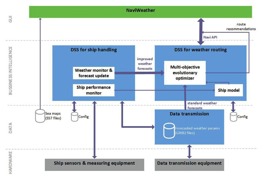
Besides representing an innovative approach to a ship’s            the best candidate routes. Unfortunately, a solution found
operational risk assessment, this method allows the smooth            for one ensemble member can perform poorly for another
integration of ensemble forecasts, thus taking into account           member and there is no certain way of obtaining a solution
uncertainties associated with weather predictions (which              that would be acceptable (safe) for all ensemble members.
are most significant in weather routing). In addition, this              The second possibility is that each combination of ensemble
methodology allows consideration of special threats which are         forecast and basic objective could represent a separate, new
difficult to include in traditional approaches (e.g. ice, traffic,    optimisation objective. Unfortunately, this means that if
human errors and piracy), as well as other factors affecting          there were, for example, 20 ensemble members and 3 basic
the efficacy of the mission from a wider perspective (such            optimisation objectives, this would produce 60 separate
as fuel consumption and voyage duration) once the targets             optimisation objectives, which is impossible to handle efficiently.
are defined.                                                             The third option is handling all ensemble members during
   The method described so far, deals with handling                   a single run of the weather routing optimisation process,
uncertainties within the constraints of the optimisation.             taking into account just three optimisation objectives. For
The proposed probabilistic approach requires the definition of        each considered route, an objective’s value can be computed
the objectives (дi) by means of a response surface, calculated        separately for all ensemble forecast members and then
for a series of expected weather conditions. Expanding                aggregated, by means of a weighted average, which can be
the response surface in its first order Taylor series, the First      biased towards a pessimistic assessment of the objective
Order Second Moment (FOSM) method can be used to                      values. As for weather-related safety constraints, they would
estimate the expected value (μдi) of the objective of interest as     also have to be checked separately for all combinations of
well as its variance (σ2дi)in a specific navigation location. Thus:   considered routes and all weather forecast ensemble members.
                                                                      However, in terms of constraints, instead of a weighted
                   μдi ≈ дi (μx1 , …, μxn)         (4)                average, the most pessimistic assessment obtained over all
                                                                      ensemble members should be taken into account. Owing to
                                                                      this, a route could only be considered acceptable if it is safe
                                                                (5)   for all ensemble members.
                                                                         The third ensemble approach, described above, is the one
                                                                      that combines acceptable computational time (due to a limited
where ρij represent the correlation coefficients between              number of optimisation objectives) with satisfying safety
the variables influencing the given objective, which must be          checks (all weather forecast ensemble members are taken
estimated numerically.                                                into account). Therefore, it is this solution that is considered in
   The objectives of the optimisation procedure (and its              terms of the ensemble-based approach to uncertainty handling.
associated uncertainties) can then be calculated by summing
the expected values and variances for all the tracks that
comprise the route.                                                   FORECAST UPDATE THROUGH REAL-TIME
                                                                               WAVE ESTIMATION
ENSEMBLE APPROACH                                                        One of the key aspects of the project is the ad-hoc
                                                                      correction of weather predictions, tailored to the navigation
    An alternative to the ‘probabilistic approach’ is                 area of interest. Monitoring of ship behaviour and
the ‘ensemble approach’. In the probabilistic approach,               on-board performance is more and more affordable, as
the sea-state (described by the HS , TP duplet in Fig. 1) is          well as communication and data exchange between ship
represented by a contour of decreasing probabilities, centred         and shore. This gathering of information does not always
on the mean forecasted conditions. In the ensemble approach,          correspond to a capability of taking effective advantage of
the predicted sea-state is given by 20 different but equally          the new possibilities offered. Within the scope of this project,
probable forecasts. The different variants in the forecast are        the ship-buoy analogy can be exploited to offer a continuous
called ensemble members and can be directly processed by              assessment of the actual sea-state along the followed route,
the optimisation method. Theoretically, ensemble members              due to a suitable on-board monitoring system.
can be handled in a number of ways but, as will be shown                 The estimation of the directional wave spectrum, based
here, some of them are not satisfying, in terms of effectiveness      on ship motions, is achieved through a parametric procedure
or efficiency. Three possibilities are briefly discussed below.       [16, 31, 32]. The wave spectrum is a-priori assumed to be
    First of all, the weather routing optimisation process            composed of one or more wave systems, each characterised by
could be run separately for each of 20 ensemble members               a parameterised spectral shape (e.g. the generalised JONSWAP
and then the results would be aggregated. In this case                spectrum). The parameters governing the spectral model are
the optimisation process would be run 20 times, including             estimated by applying a genetic algorithm to fit the current
all three optimisation objectives in each run. Each ensemble          sea-state conditions.
member would produce a separate set of Pareto-optimal                    The sea-state estimation method has been tested on board
solutions, which could then be joined and filtered to select          a relatively small navy ship (28.4 m long) equipped with a full

                                                                        POLISH MARITIME RESEARCH, No 1/2020                         63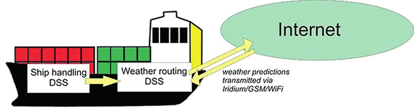
monitoring system including, among the others, redundant                       ship measurements for the improvements of meteorological
accelerometers and angular rate sensors, accurate GPS and                      prediction and safety.
a wave radar for real time measurements of the encountered
sea-state. The monitoring system was integrated in ViewLab
(see Fig. 3).                                                                                         SYSTEM DESIGN

                                                                                    The proposed ROUTING system (Fig. 5) would consist of
                                                                               the following elements:
                                                                               - s hip handling decision support system (ship handling DSS),
                                                                               - weather routing decision support system (weather routing
                                                                                  DSS),
                                                                               - ship-internet data transmission module.
                                                                                    The main objective of the weather routing DSS would
                                                                               be to provide a route recommendation for given departure
                                                                               and destination points, taking into account forecast weather
                                                                               conditions as well as a pre-defined set of optimisation criteria
                                                                               and constraints (both static and dynamic) for the ship having
                                                                               the system installed. Some parts of the data processed by
                 Fig. 3. ViewLab user interface (from 16)
                                                                               the DSS would be uncertain and the uncertainty would
                                                                               propagate through the system (as described earlier) and, thus,
   A comparison of the estimated wave spectrum (1D to                          an uncertainty level is associated with the objectives that are
simplify the visualisation) and the measured one is shown                      achievable, following the resulting recommendation. However,
in Fig. 4.                                                                     the system would be able to work just as well with entirely
                                                                               certain data sources (with no uncertainty level defined).
                                                                                    The optimisation part of the weather routing DSS would
                                                                               be implemented as multi-objective metaheuristics (MOMH),
                                                                               most probably based on the SPEA 2 method [60] but strongly
                                                                               customised to suit the special requirements of the weather
                                                                               routing problem. The optimisation criteria set would include
                                                                               two economy-related criteria (fuel consumption [35] and
                                                                               passage time [12] or delay) as well as a safety-related criterion
                                                                               (modelled as safety index, taking into account ship stability
                                                                               and other factors). The set of constraints would allow for
                                                                               the inclusion of land and shallow waters, as well as areas of
  Fig. 4. Comparison of estimated and measured wave spectrum (from 16)         excessive wave or wind conditions and areas with violations
                                                                               of IMO Circ. #1228 (which states that some combinations of
   The actual sea-states computed through the above-                           wave length and wave height may lead to dangerous situations
mentioned procedure can then be compared with the predicted                    for ships, under certain operating conditions).
ones. The availability of the information regarding the gap                         Proper modelling of the ship response parameters (made
between the two values in real-time and along the ship route,                  for the ship on which a prototype of the system would be
can be used to update the weather forecast through a data                      installed and tested) would be one of the crucial elements
assimilation procedure [1, 17, 37].                                            required for successful deployment of the ROUTING system.
   The proposed procedure is promising, not only for                           Thus, a ‘ship model’ library or module would be separated
providing more reliable inputs to the route optimisation                       inside of the weather routing DSS, providing information
system (achieving up to 25% of improvement in the forecast                     about the ship’s optimal operational parameters (speed,
in the vicinity of the measurement spot, as shown in [17]) but,                fuel consumption, safety index, etc.) for given forecasted
also, to fully exploit the widely-recognised value of in-situ                  weather conditions. Separating the ship model from the route

                                                Fig. 5. A general overview of the proposed ROUTING system

 64          POLISH MARITIME RESEARCH, No 1/2020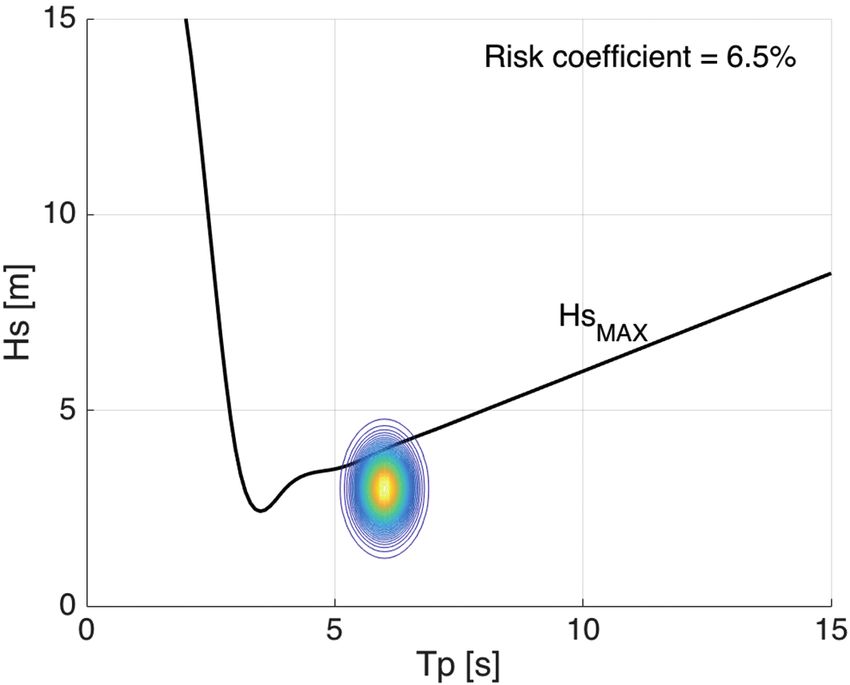
optimiser is good design and programming practice, since it During the project, a hardware and software tool would be
strongly facilitates the process of exchanging the ship model constructed to optimise the transmission costs, where available.
(in the case of changing the ship operating the system) but An overview of the architecture of the entire ROUTING system
keeping the rest of the DSS intact. proposed is provided in Fig. 6.
The ROUTING system would utilise commercial ENC-
class software [28] (NaviWeather, (NavSim, Poland) which
would, above all, provide a means of uploading, analysing and IN SERVICE EXPERIENCE
displaying weather data, targeted at yachts and fishing vessels
as well as commercial marine transportation. The tool will be With the aim of demonstrating the complete operability
utilised as a source of S-57 sea maps and provide an interface of the system, an agreement has been reached with
for GRIB files and weather forecast data. NaviWeather will the Portuguese shipping company Transinsular, making
provide a Graphical User Interface (GUI) for communication possible the realisation of a six-month long, full-scale test,
with users and present route recommendations. The weather under actual operational and weather scenarios. An on-board
routing DSS would be integrated with NaviWeather by monitoring system will be installed on an 8,850 t, 126 m long
NaviAPI as a separate software plugin. container vessel sailing the North Atlantic waters around
The weather routing DSS would be located on a shore- the Iberian Peninsula (connecting continental Portugal to
based server to achieve high computational power and faster, Madeira and the Azores (Fig. 7)). The system is expected to
cheaper access to standard weather forecasts. However, measure or retrieve all the required information to be used
additional client-server communication would be required for the estimation of the sea spectrum data assessment from
to achieve ship to shore data transmission. These data packets the ship data acquisition tools. Post-processing of the data
would include: would be carried out in order to analyse the accuracy of
- origin and destination points (lon; lat), the models adopted and the efficacy of the optimisation
- departure and ETA, method implemented, by comparing the actual route
- ship performance statistics (to be uploaded to a data with the proposed one. Furthermore, with the scope of
assimilation module). providing an insight into the integration of the system into
In the opposite direction, ‘shore to ship’ packets of data would daily, on-board operations, a short and simple template
include the following:
- resulting routes,
- limited weather forecasts (compared to the server-side) to
be displayed to the user to show the routes’ performance.
The last data transmission module of the ROUTING
system would handle all of the required ship-internet data
transmissions. It would be associated with on-board equipment
in order to allow interactive performance. Since transmission
of vast weather forecast files via the satellite channel (Iridium)
might be expensive, some kind of transmission cost
optimisation would be required, as well as the application of
proper system architecture for minimising the required data
exchange. Therefore, in the ROUTING system, ship-shore-
ship transmission would be realised via one of the Wi-Fi/
GSM/Iridium satellite radio-modem communication channels.
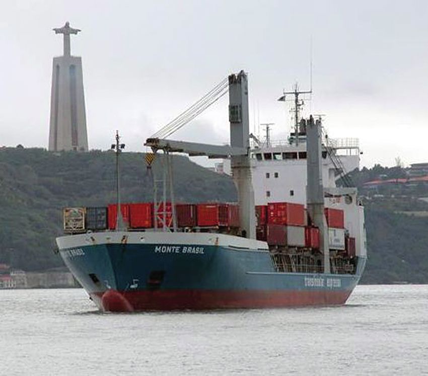
Fig. 6. Overview of the proposed ROUTING system architecture Fig. 7. Monte Brasil container-ship approaching the port
of Lisbon (top) and typical route sailed
POLISH MARITIME RESEARCH, No 1/2020 65will be prepared for the seafarers in charge to record their ACKNOWLEDGMENTS
experiences using the tools. This will eventually allow us
to highlight any erroneous performance issues, as well This research was supported by The National Centre for
as any difficulties in the utilisation of the DSS (for ship Research and Development in Poland and by the Portuguese
handling and weather routing) created during the course Foundation for Science and Technology (Fundação para
of the project. a Ciência e Tecnologia – FCT) under grants for the ROUTING
The configuration of the on-board monitoring system will research project (MARTERA-1/ROUTING/3/2018)
exploit the experiences encountered by previous projects [34]. in the ERA-NET COFUND MarTERA-1 programme
The System Sensors are responsible for measurements of (2018-2021).
a ship’s motions, the speed and location, the weather
conditions (in terms of wind), waves and sea-surface currents,
the engine operation point and fuel consumption and, REFERENCES
possibly, the structural stresses of the hull girder. The sensors
include a GPS, a midship inertial measurement unit (IMU), 1. Almeida S. L., Rusu C. G., Soares. (2016): Data assimilation
a bow accelerometer, a weather station, a wave sensor, long- with the ensemble Kalman filter in a high-resolution wave
base strain gauges and a flow meter. The integration of all forecasting model for coastal areas, 9, 103–114.
data is carried out through a data acquisition system and
sent to a computer located on the bridge, where the GUI and 2. Alves, J.H.G.M., P. Wittmann, M. Sestak, J. Schauer,
the NaviWeather software are installed to communicate with S. Stripling, N.B. Bernier, J. McLean, Y. Chao, A. Chawla,
the user. The ship will also be equipped with a communication H. Tolman, G. Nelson, S. Klotz: The NCEP–FNMOC
system designed to transmit information ashore, where Combined Wave Ensemble Product, Am. Meteorol. Soc.
the heaviest calculations are performed (e.g. the data (2013) 1893–1905.
assimilation and weather forecast update) and developers
can control the correct functionality of the system. 3. Antao, P., C. Guedes Soares: Analysis of the Influence of
Human Errors in the Occurrence of Coastal Ship Accidents in
Different Wave Conditions using Bayesian Belief Networks,
CONCLUSIONS Accid. Anal. Prev. 133 (2019) 105262.
The paper presents the first phase of research on 4. Bidlot, J.-R.: Twenty one years of wave forecast verification,
the ROUTING project. The project aims at developing ECMWF Newsl. 150. (2017).
a novel solution for optimising ship routes, based on detailed
models of ship behaviour, dynamic hydro-meteorological 5. Chen, C., S. Shiotani, K. Sasa: Numerical ship navigation
data and refined multi-objective meta heuristics (MOMH). based on weather and ocean simulation, Ocean Eng. 69
The data sources will include weather forecasts, updated (2013) 44–53.
dynamically with real-time information, gathered by
the ship sensors. The solution under development will 6. Chen, H.: Weather routing versus voyage optimisation, Digit.
take into account multiple problem-related uncertainties, Sh. (2013) 26–27.
including those associated with weather forecasts and
those resulting from ship performance and responses to 7. Christiansen, M., K. Fagerholt, B. Nygreen, D. Ronen: Ship
sea conditions. As for the former, they will be modelled routing and scheduling in the new millennium, Eur. J. Oper.
here as ensemble forecasts and directly taken into account Res. 228 (2013) 467–483.
in the long-term optimisation process. The latter will be
handled by a short-term Decision Support System. All of 8. Fonseca, N., C. Guedes Soares: Sensitivity of the Expected
the available data will be processed by the main module of Ships Availability to Different Seakeeping Criteria, in: 21st
the system, utilising state-of-the-art, evolutionary, multi- Int. Conf. Offshore Mech. Arct. Eng. (Volume 4), Oslo,
objective optimisation (EMO) and incorporating decision Norway, 2002: pp. 23–28.
maker (DM) preferences by means of configurable trade-offs
between various optimisation objectives. The final results 9. Guedes Soares, C.: Effect of Heavy Weather Maneuvering
(routes recommended by the system) will be transmitted on the Wave-Induced Vertical Bending Moments in Ship
to the client application on board a ship and visualised in Structures, J. Sh. Res. 34 (1990) 60–68.
the ENC-class NaviWeather software. The proposed solution
will be implemented as a prototype system and verified 10. Guedes Soares, C., E.M. Bitner-Gregersen, P. Antão:
on board a container-ship navigating between continental Analysis of the Frequency of Ship Accidents Under Severe
Portugal and its archipelagos of Madeira and the Azores. North Atlantic Weather Conditions, in: Des. Oper. Abnorm.
The obtained results will be disseminated as well as used Cond. II, 2001: pp. 221–230.
for further research on ship routing and ship behaviour in
various weather conditions.
66 POLISH MARITIME RESEARCH, No 1/202011. Guedes Soares, C., M. Dogliani, C. Ostergaard, G. Parmentier, Transportation Systems – A case study for open sea collisions
P.T. Pedersen: Reliability Based Ship Structural Design, Trans. involving ..., Reliab. Eng. Syst. Saf. 124 (2014) 142–157.
Soc. Nav. Archit. Mar. Eng. 104 (1996) 357–389.
26. Motte, R.H., S. Calvert: On The Selection of Discrete Grid
12. Guedes Soares, C., N. Fonseca, J. Ramos: Prediction of Voyage Systems for On-Board Micro-based Weather Routeing,
Duration with Weather Constraints, in: Proc. Int. Conf. Sh. J. Navig. 43 (1990) 104–117.
Motions Manoeuvrability, Royal Institute of Naval Architects,
London, UK, 1998: pp. 1–13. 27. Natskår, A., T. Moan, P.Ø. Alvær: Uncertainty in forecasted
environmental conditions for reliability analyses of marine
13. Guedes Soares, C., A.P. Teixeira: Risk assessment in maritime operations, Ocean Eng. 108 (2015) 636–647.
transportation, Reliab. Eng. Syst. Saf. 74 (2001) 299–309.
28. NavSim: NaviWeather, http://www.naviweather.eu. (2018).
14. Hagiwara, H., J.A. Spaans: Practical Weather Routing of Sail-
assisted Motor Vessels, J. Navig. 40 (1987) 96–119. 29. Padhy, C.P., D. Sen, P.K. Bhaskaran: Application of wave model
for weather routing of ships in the North Indian Ocean, Nat.
15. Hinnenthal, J., G. Clauss: Robust Pareto-optimum routing of Hazards. 44 (2008) 373–385.
ships utilising deterministic and ensemble weather forecasts,
Ships Offshore Struct. 5 (2010) 105–114. 30. Papanikolaou, A., G. Zaraphonitis, E.M. Bitner-Gregersen,
V. Shigunov, O. El Moctar, C. Guedes Soares, D.N. Reddy,
16. Hinostroza, M., C. Guedes Soares: Parametric estimation of F. Sprenger: Energy Efficient Safe SHip Operation (SHOPERA),
the directional wave spectrum from ship motions, Int. J. Marit. Transp. Res. Procedia. 14 (2016) 820–829.
Eng. 158 (2016) A121–A130.
31. Pascoal, R., C. Guedes Soares: Non-parametric wave spectral
17. Holthuijsen, L.H., N. Booij, M. van Endt, S. Caires, C. Guedes estimation using vessel motions, Appl. Ocean Res. 30 (2008)
Soares: Assimilation of Buoy and Satellite Data in Wave 46–53.
Forecasts with Integral Control Variables, J. Mar. Syst. 13
(1997) 21–31. 32. Pascoal, R., L.P. Perera, C. Guedes Soares: Estimation of
directional sea spectra from ship motions in sea trials, Ocean
18. Hu, S., Q. Fang, H. Xia, Y. Xi: Formal safety assessment based Eng. 132 (2017) 126–137.
on relative risks model in ship navigation, Reliab. Eng. Syst.
Saf. 92 (2007) 369–377. 33. Perera, L.P., C. Guedes Soares: Weather routing and safe ship
handling in the future of shipping, Ocean Eng. 130 (2016)
19. Hussein, A.W., C. Guedes Soares: Reliability and residual 684–695.
strength of double hull tankers designed according to the new
IACS common structural rules, Ocean Eng. 36 (2009) 34. Perera, L.P., J.M. Rodrigues, R. Pascoal, C. Guedes Soares:
1446–1459. Development of an onboard decision support system for
ship navigation under rough weather conditions, in:
20. James, R.W.: Application of wave forecast to marine navigation, Rizzuto, Guedes Soares (eds.), Sustain. Marit. Transp.
US Naval Oceanograph, 1957. Exploit. Sea Resour., Taylor & Francis Group, London,
2012: pp. 837–844.
21. Krata, P., J. Szlapczynska: Ship weather routing optimization
with dynamic constraints based on reliable synchronous roll 35. Prpić-Oršić, J., R. Vettor, O.M. Faltinsen, C. Guedes Soares:
prediction, Ocean Eng. 150 (2018). The influence of route choice and operating conditions on fuel
consumption and CO2 emission of ships, J. Mar. Sci. Technol.
22. Leutbecher, M., T.N. Palmer: Ensemble forecasting, J. Comput. 21 (2016) 434–445.
Phys. 227 (2008) 3515–3539.
36. Rizzuto, E., Â. Teixeira, C. Guedes Soares: Reliability
23. Mannarini, G., G. Coppini, P. Oddo, N. Pinardi: A Prototype Assessment of a Tanker in Grounding Conditions, in: Proc.
of Ship Routing Decision Support System for an Operational 11th Int. Symp. Pract. Des. Ships Other Float. Struct., Rio de
Oceanographic Service, in: TransNav, 2013: pp. 53–59. Janeiro, Brazil, 2010: pp. 1446–1458.
24. Marie, S., E. Courteille: Multi-Objective Optimization of 37. Rusu, L., C. Guedes Soares: Impact of assimilating altimeter
Motor Vessel Route, Int. J. Mar. Navig. Saf. Seas Transp. 3 data on wave predictions in the western Iberian coast, Ocean
(2013) 133–141. Model. 96 (2015) 126–135.
25. Montewka, J., S. Ehlers, F. Goerlandt, T. Hinz, K. Tabri, 38. Shao, W., P. Zhou, S.K. Thong: Development of a novel forward
P. Kujala: A framework for risk assessment for Maritime dynamic programming method for weather routing, J. Mar.
Sci. Technol. 17 (2012) 239–251.
POLISH MARITIME RESEARCH, No 1/2020 6739. Silveira, P., A. Teixeira, C. Guedes Soares: Use of AIS Data 52. Vettor, R., C. Guedes Soares: Multi-objective Route
to Characterise Marine Traffic Patterns and Ship Collision Optimization for Onboard Decision Support System, (2015)
Risk off the Coast of Portugal, J. Navig. 66 (2013) 879–898. 99–106.
40. Simonsen, M.H., E. Larsson, W. Mao, J.W. Ringsberg: State- 53. Vettor, R., C. Guedes Soares: Development of a ship weather
of-the-art withing Ship Weather Routing, in: Proc. ASME routing system, Ocean Eng. 123 (2016) 1–14.
2015 34th Int. Conf. Ocean. Offshore Arct. Eng., St. John’s,
Newfoundland, Canada, 2015: pp. 1–11. 54. Vettor, R., C. Guedes Soares: Rough weather avoidance effect
on the wave climate experienced by oceangoing vessels, Appl.
41. Skoglund, L., J. Kuttenkeuler, A. Rosén: A new method for Ocean Res. 59 (2016) 606–615.
robust route optimization in ensemble weather forecasts,
(2012). 55. Vettor, R., C. Guedes Soares: Characterisation of the expected
wave conditions in the main European coastal traffic routes,
42. Szlapczynska, J.: Multiobjective Approach to Weather Routing, Ocean Eng. 140 (2017) 224–257.
TransNav, Int. J. Mar. Navig. Saf. Sea Transp. 1 (2007)
273–278. 56. de Wit, C.: Proposal for Low Cost Ocean Weather Routing, J.
Navig. 43 (1990) 428–439.
43. Szlapczynska, J.: Multi-objective Weather Routing with
Customised Criteria and Constraints, J. Navig. 68 (2015) 57. WMO: Guidelines on Ensemble Prediction Systems and
338–354. Forecasting, Report No 1091, 2012.
44. Szlapczynska, J., R. Szlapczynski: Preference-based 58. Zaccone, R., E. Ottaviani, M. Figari, M. Altosole: Ship
evolutionary multi-objective optimization in ship weather voyage optimization for safe and energy-efficient navigation:
routing, Appl. Soft Comput. J. 84 (2019) 105742. A dynamic programming approach, Ocean Eng. 153 (2018)
215–224.
45. Teixeira, A., C. Guedes Soares: On the Reliability of Ship
Structures in Different Coastal Areas, in: Shiraishi, Shinozuka, 59. Zhang, J., A.P. Teixeira, C. Guedes Soares, X. Yan, K. Liu:
Wen (eds.), Struct. Saf. Reliab., A.A. Balkema, Japan, 1998: Maritime Transportation Risk Assessment of Tianjin Port with
pp. 2073–2076. Bayesian Belief Networks, Risk Anal. 36 (2016) 1171–1187.
46. Teixeira, A.P., C. Guedes Soares: Reliability assessment of 60. Zitzler, E., M. Laumanns, L. Thiele: SPEA2: Improving
intact and damaged ship structures, in: (eds), G.S.& P. (Ed.), the Strength Pareto Evolutionary Algorithm, Evol. Methods
Adv. Sh. Des. Pollut. Prev., Taylor & Francis Group, London, Des. Optim. Control with Appl. to Ind. Probl. (2001) 95–100.
2010: pp. 79–94.
61. Zyczkowski, M., P. Krata, R. Szlapczynski: Multi-objective
47. Teixeira, A.P., C. Guedes Soares, G. Wang: Reliability Based weather routing of sailboats considering wave resistance, Polish
Approach to Determine the Design Loads for the Remaining Marit. Res. 25 (2018) 4–12.
Hull Lifetime, in: Guedes Soares, C., G. Y., N. Fonseca (eds.),
Marit. Transp. Exploit. Ocean Coast. Resour., Taylor & Francis 62. Zyczkowski, M., R. Szlapczynski: Multi-Objective Weather
Group, London, UK, 2005: pp. 1611–1620. Routing of Sailing Vessels, Polish Marit. Res. 24 (2017).
48. Trucco, P., E. Cagno, F. Ruggeri, O. Grande: A Bayesian Belief
Network modelling of organisational factors in risk analysis:
A case study in maritime transportation, Reliab. Eng. Syst.
Saf. 93 (2008) 823–834.
49. Tsou, M.-C.: Integration of a Geographic Information System
and Evolutionary Computation for Automatic Routing in
Coastal Navigation, J. Navig. 63 (2010) 323–341.
50. Varelas, T., S. Archontaki, J. Dimotikalis, O. Turan, I. Lazakis,
O. Varelas: Optimizing ship routing to maximize fleet revenue
at Danaos, Interfaces (Providence). 43 (2013) 37–47.
51. Vettor, R., C. Guedes Soares: Detection and analysis of
the main routes of voluntary observing ships in the North
Atlantic, J. Navig. 68 (2015) 397–410.
68 POLISH MARITIME RESEARCH, No 1/2020CONTACT WITH THE AUTHORS
Roberto Vettor
e-mail: roberto.vettor@centec.tecnico.ulisboa.pt
Instituto Superior Técnico, Universidade de Lisboa
Av. Rovisco Pais, 1049-001 Lisbon
Portugal
Joanna Szlapczynska
e-mail: j.szlapczynska@wn.umg.edu.pl
Gdynia Maritime University, Faculty of Navigation
Morska, 81-225 Gdynia
Poland
Rafal Szlapczynski
e-mail: rafal.szlapczynski@pg.edu.pl
Gdańsk University of Technology
Narutowicza 11/12, 80-233 Gdańsk
Poland
Wojciech Tycholiz
e-mail: wojtek.tycholiz@navsim.pl
Navsim Poland
Różana 95, 59-700 Bolesławiec
Poland
Carlos Guedes Soares
e-mail: c.guedes.soares@centec.tecnico.ulisboa.pt
Instituto Superior Técnico, Universidade de Lisboa
Av. Rovisco Pais, 1049-001 Lisbon
Portugal
POLISH MARITIME RESEARCH, No 1/2020 69You can also read