Union Station Multi-Modal Transportation Assessment - Portland Union Station - Phase III(B)
←
→
Page content transcription
If your browser does not render page correctly, please read the page content below
Portland Union Station – Phase III(B)
Union Station Multi-Modal Transportation Assessment
FINAL REPORT
September 2017
Contents

           1. Introduction                      3

           2. Key Findings                      7

           3. Transportation at Union Station   10

           4. Union Station Driveway            31

           5. Future Design Considerations      43

           6. Greyhound Precedents              49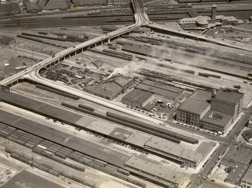
1. Introduction
Introduction
This document provides an overview of multi-modal
transportation services, facilities, and issues in the vicinity of
Portland Union Station.
This study was commissioned by Prosper Portland (formerly the
Portland Development Commission) as part of its ongoing efforts
related to the redevelopment of Portland Union Station and
planning for the Broadway Corridor.

Union Station and its immediate vicinity serve as the primary
intercity passenger rail and bus terminal in the Portland
metropolitan area, and also provides connections to local transit
including light rail, bus, streetcar, taxi, rideshare, and bike share.

The Union Station vicinity is undergoing rapid growth and change
as the result of several major initiatives including:
• The Broadway Corridor Framework Plan (2015), outlining a
  concept for the Post Office Site and other redevelopment
  parcels around Union Station.
• The Union Station Phase III PE/NEPA project, focused on
  critical repairs and revitalization of the historic station.

• Potential relocation and downsizing of the Greyhound Terminal
  in response to changing service levels.
• Planning and design for TriMet’s Division Bus Rapid Transit              Union Station and Vicinity
  (BRT) project, which would terminate and construct layover
  facilities near Union Station.

The objective of this report is to familiarize the reader with
existing and proposed transportation conditions of the area, and
how transportation needs may impact future corridor decisions
related to facilities, infrastructure, and urban development in the
vicinity.

                                                                                                        4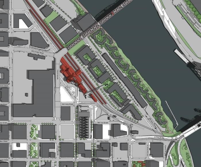
Stakeholders Consulted
The following project stakeholders were consulted by Prosper Portland
and IBI Group through meetings and interviews during the course of this
study.

• Portland Bureau of Transportation (multi-modal transportation,
  pedestrian/bicycle infrastructure, Green Loop)

• TriMet Capital Projects Division (Division BRT)

• Oregon Department of Transportation – Public Transportation
  Division (intercity bus services)

• Greyhound Lines (intercity bus operator)

• NW Agency Management LLC (Greyhound Terminal agent)

• Multnomah County Health Department (new headquarters under
  construction near Union Station at SW 6th Avenue and NW Hoyt Street)

• Transition Projects, Inc. (Bud Clark Commons)

• Pacific Northwest College of Art (local institution/property owner)

• Falcon Art Community (neighborhood stakeholder/property owner)

These consultations provide perspectives and insight on transportation
design and socioeconomic issues impacting, and impacted by,
transportation in the Union Station vicinity.

Prosper Portland also facilitated coordination and information exchange
between this work and two related Prosper Portland initiatives: the
Broadway Corridor Framework Plan, and the Portland Union Station               Union Station Clock Tower from the Steel Bridge
PE/NEPA project.

                                                                                                                                 5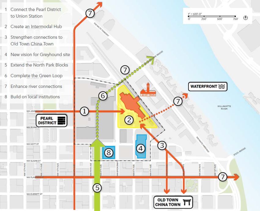
Union Station Vicinity
The study encompasses an area roughly
bounded by NW 9th Avenue on the west,
NW Glisan Street on the south, SW Naito
Parkway on the east, and the Union             Post Office
Pacific/BNSF railroad tracks on the east.         Site
This study area includes several key
transportation assets and development
parcels, including:

• Portland Union Station                                       Union
• Greyhound Terminal                                           Station

• Post Office Site
                                                                   Block Y
• Block Y (owned by Prosper Portland)

• Block R (owned by Prosper Portland)                                        Greyhound
• Other public and privately owned                                            Terminal
  redevelopment sites in the Broadway
  Corridor

Given the porous nature of the multi-
modal transportation system, certain key
transportation facilities and assets outside
of the immediate study area were
considered in this assessment – for                                                 Block R
example, the Portland Streetcar alignment
and stations along NW 10th and 11th
Avenues.

                                                                                              6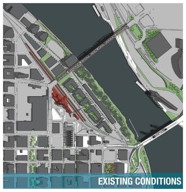
2. Key Findings
Key Findings
Union Station is a Multimodal Transportation Hub of                         Multiple Intercity Bus Services Serve the Area, but are
Regional Significance. Union Station and environs are a gateway             Dispersed Among Several Terminals. While Amtrak and
to Portland connecting the city with the state through passenger rail       Greyhound are the dominant intercity carriers operating in the area,
and intercity bus connections, as well as local transit, taxi, rideshare,   a number of other regional and interstate bus lines provide key
bikeshare, pedestrian, and bicycle infrastructure. These mutually-          connections across Oregon and the Northwest. Together, these
supportive modes provide mobility to, from, and within the region.          services provide feeder services to rail and bus lines, and form a de
Over 590,000 passengers use Amtrak rail and Thruway bus services            facto hub of intercity bus lines for travel across the state. Today,
alone, with additional passengers using the wide range of private           however, there is no single terminus, as services divided between
and public inter-city and local transportation services.                    Union Station, the Greyhound Terminal, and the BoltBus stop on
                                                                            NW Everett Street. Passenger amenities vary widely among the
The Union Station Vicinity Continues to Evolve from its                     facilities. These carriers create a “hidden network” that should be
Railroad/Industrial Origins to High Density Mixed Use.                      considered in future decisions about multimodal facilities.
Through much of the 20th century, Union Station and vicinity was a
primarily industrial area, dominated by rail yards, factories, and
warehouses. Changes in the past 25 years have transformed the area
into a mixed use urban neighborhood. Further changes are
anticipated in the next 10-20 years with the redevelopment of the
Post Office Site, Greyhound site, and other key parcels in the
Broadway Corridor.

Balancing Urban Development and Placemaking with
Critical Transportation Functions is Increasingly Important
as the Neighborhood Intensifies. Union Station is a potential
focal point for the emerging neighborhoods in the Broadway
Corridor, with significant increases in density and new street
connections and public spaces surrounding the station. This
represents a once-in-a-lifetime placemaking opportunity for the
Broadway Corridor, but it is critical to also maintain access to Union
Station and other critical transportation support functions, like
TriMet Transit Mall operations, as the neighborhood evolves and
pressure increases on local roadways, parking, and transit systems.

                                                                                                                                            8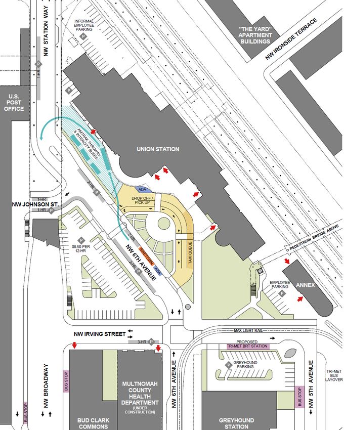
Key Findings
The Union Station Driveway Accommodates Diverse                        Peer Cities offer Varied Examples for Replacing the
Functions, but has Deficiencies in its Current                         Greyhound Terminal in Portland. The currently Portland
Configuration. The driveway accommodates pick-up/drop-off              Greyhound Terminal, built in the 1980s, has excess capacity
activity, taxis, rideshare, intercity bus, deliveries, and emergency   based on future requirements provided by Greyhound. Like rail
access. The growth in Transportation Network Companies and             passengers, Greyhound passengers benefit from co-location with
changing travel behavior to and from the station suggest that          other transportation modes in and around Union Station.
curb utilization and roadway configuration could be re-optimized.      Facilities in other cities provide diverse examples of how a
Design improvements could also enhance the connection to the           redesigned, downscaled, or relocated Greyhound Terminal could
Station Place parking garage, a key facility for rail travelers and    be designed. These include: multi-modal transportation centers;
building users. These changes must be addressed in a way that is       Greyhound terminals co-located with Amtrak stations, and stand-
mindful of both the historic building as well future visions for       alone facilities. In Seattle and Sacramento, the Greyhound
public spaces in front of Union Station.                               terminal was relocated to the edge of the central business
                                                                       district, where land prices and highway access are more favorable
Improvements to Bicycle/ Pedestrian Access and                         to a low-cost. There are also examples of facilities incorporated
Wayfinding would better connect Union Station to                       into structured parking and mixed-use developments, which may
Surrounding Neighborhoods and Transit. Travelers,                      be relevant models for a new terminal located on a key
                                                                       redevelopment parcel within the Broadway Corridor.
employees, and visitors to Union Station will benefit from
pedestrian and bicycle connections in the vicinity, such as the
                                                                       Future Transportation and Design Decisions in the
proposed Green Loop and the proposed extension of SW Johnson
Street through the Post Office Site. Such connections will help to     Broadway Corridor Should Consider the Combined
integrate Union Station with this emerging neighborhood, and           Impacts on Mobility, Placemaking, Equity, and
will greatly improve access to the Portland Streetcar.                 Economic Development. Transportation and urban
Connections to and along NW Glisan Street and/or NW Flanders           development decisions are highly intertwined in the Broadway
street would increase connectivity to Old Town/Chinatown,              Corridor. Development of transportation facilities, whether for
waterfront trails, and key east-west connections through the           the Division BRT or Union Station driveway, or district parking
Central City. Existing connections to the Portland Transit Mall and    facilities, are inextricably linked to other design decisions and
other transit services are generally good, though improved             desired community outcomes. The area immediately in front of
wayfinding would benefit arriving passengers and those                 Union Station, including the driveway, NW Station Way, and Block
unfamiliar with the area.                                              Y merits particular attention. NW Glisan Street and underside of
                                                                       the Broadway Viaduct are examples of other areas where
                                                                       transportation facilities decisions could have a highly positive or
                                                                       detrimental effect on the look and feel of the neighborhood for
                                                                       many years to come.                                                 9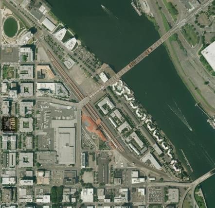
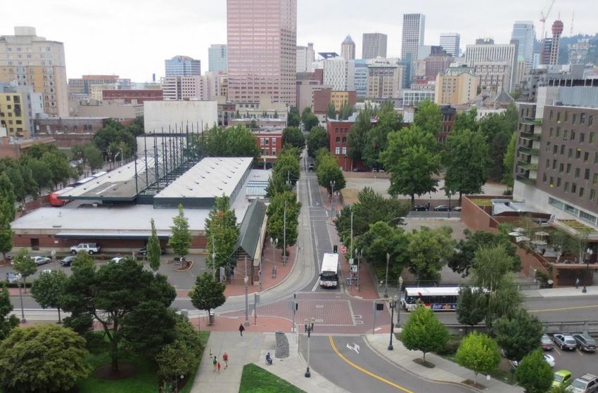
3. Transportation at Union Station
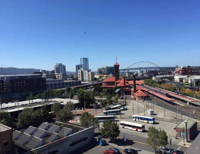
Transportation at Union Station
Portland Union Station and environs is one of two multi-modal
transportation hubs in the City of Portland – the other being
Portland International Airport. Hundreds of thousands of
Portlanders and visitors pass to and from this area each year as a
gateway to the city.

Located in the Portland Central City, Union Station connects
intercity rail and bus services, TriMet MAX light rail and bus
services, and Portland Streetcar. The vicinity is also served by key
existing and proposed pedestrian and bicycle connections,
including on-street bicycle paths, connections to the riverfront,
and the proposed Green Loop project.

Convenient and efficient transportation connections, including
among the modes described above, is vital for regional
connectivity as well as the prosperity and development of the
Broadway Corridor and surround neighborhoods.                                Union Station, Greyhound Terminal, and TriMet facilities, looking north

                                                                                                                                                   11
Transportation Connectivity - Union Station Vicinity
Intercity Passenger Rail (Amtrak)
Intercity Bus
Taxi Stand
TriMet MAX Light Rail (Transit Mall)
P
TriMet Local Bus Stop
Portland Streetcar
Union BikeTown Bike Share
Station
USPS
Site
P Public Off-Street Parking
P
Layover Facility
P
Transit Mall NB
Transit Mall SB
(NW Everett St) P P
P
12Impacts of Future Development on Transportation
The area around Union Station is undergoing rapid change from an
industrial, railroad focused neighborhood of 100 years ago, to a
dense, mixed-use urban community. The Broadway Corridor
includes a number of brownfield and underutilized parcels
envisioned for higher density development in the immediate vicinity
of the station.
Redevelopment of the 13.4-acre Post Office Site adjacent to Union
Station will have the largest potential impact. A new Multnomah
County Health Department headquarters (on Block U) will bring 350
employees to the site. Other key redevelopment opportunities
include Prosper Portland owned Block R and Block Y.
Redevelopment of the Greyhound site (with or without a downsized
Greyhound Terminal on site) would create additional density in the
area.
Implications to transportation include increased travel demand and
increased pressure on parking. Higher densities will create
challenges and potential conflicts with transportation operations
Union Station and future connections and
and support functions, such as transit layover and intercity bus
developments in the Broadway Corridor
terminal functions, that have been traditionally located in the area. (source: Broadway Corridor Framework Plan)
Public plaza concepts for Union Station are exciting opportunities
for urban place making, but must be balanced with access needs for
those traveling to and from the Union Station.
Additional discussion of future development and urban design
considerations is provided in Section 5.
New Multnomah County Heath Department
headquarters at SW 6th Avenue and NW Hoyt Street
(Source: Multnomah Co.) 13Portland Union Station
Built in 1896, Portland Union Station is a national historic landmark and a
recognizable icon in the City of Portland. It has been in continuous service
as a passenger rail station for over 120 years, and is the oldest continuously
operating passenger station on the West Coast. Union Station has been
owned by Prosper Portland since 1987.
Union Station is the hub for Amtrak intercity rail services to and from
Portland, including Amtrak Cascades service (Eugene, OR to Seattle, WA and
Vancouver, BC) sponsored by the Oregon and Washington Departments of
Transportation. In 2016, 590,076 Amtrak passengers passed through
Portland Union station, making it the 19th busiest Amtrak station (Source:
Amtrak).
Portland Union Station
The station is also served by two long-distance rail routes: the Amtrak Coast
Starlight between Seattle, WA, and Los Angeles, CA, and the Empire Builder
between Portland and Chicago, IL. Amtrak Cascades – North to
South to
Daily Round Trips Seattle,
Eugene
In addition to rail service, the front driveway of Union Station serves most at Portland Union Station Vancouver B.C.
Amtrak Thruway motor coach connections as well as some other regional 2017 (Current Service) 4 2
intercity bus services. Occasional casino charters also stop at Union Station. End of 2017 6 2
2035 (Long Range) 13 6
Aside from its transportation functions, Union Station also houses a
restaurant, a café, and third party office tenants in its upper floors and Sources: Amtrak Cascades 2017 Schedule;
WSDOT Long-Range Rail for Amtrak Cascades (2006);
Annex. Oregon Passenger Rail Study (2016)
Prosper Portland, in coordination with the Oregon Department of Table Notes:
Transportation and the Federal Railroad Administration, is currently One additional round trip is provided between Seattle, Portland, and Eugene and
undertaking the Portland Union Station PE/NEPA project to design critical points south by the Amtrak Coast Starlight long-distance train.
repairs and improvements that will ensure that Union Station meets the
Supplemental Amtrak Thruway bus service is provided in the Portland-Eugene
needs of its next century of service. Part of this project includes
corridor (7 weekday round trips).
revitalization and reactivation of the historic building as a focal point of the
emerging Broadway Corridor.
14Portland Union Station – Arrival and Departure Mode
Comprehensive arrival and departure mode data and volumes for all Amtrak Passenger Arrival/Departure
modes at Union Station was not available at the time of this study; Mode at Portland Union Station Arrival Departure
however a customer survey of passenger arrivals and departures Connecting Amtrak train 6% 10%
provides a glimpse into current mode split. Connecting Amtrak bus 6% 3%
Drove and parked at station 6% 1%
The data show that arrival by automobile (drop-offs/pick-ups and Carpooled and parked at station 1% 0%
driving to the station) are the predominant arrival and departure Dropped off/picked up by auto 36% 31%
mode. This is follows by access to the station via local public Local public transit 18% 15%
transportation. Private intercity bus 2% 0%
Taxi/limousine 9% 14%
Approximately 12-13% of passengers stated they were connecting to
Walk/bicycle 6% 11%
or from another Amtrak train or bus service, indicating the ‘hub’
Rental Car 2% 10%
function of Union Station.
Other 8% 4%
Connections to other intercity bus services, such as POINT or Source: Amtrak eCSI survey, March 2015 to March 2016.
Greyhound, are not explicitly reported, though may be reflected Based on 1,100 survey responses for arrival mode and 1,200 survey responses
under Connecting Amtrak Bus, Local Public Transit and Private for egress mode. Survey excludes multi-ride ticket (commuter) passengers.
Intercity Bus.
Notably, the 2015-2016 arrival/departure survey did not include an
explicitly response category for Transportation Network Companies,
car share, or bike share. It is possible that respondents using these
modes replied using one of the other available categories (e.g., Taxi,
Rental Car, or Other).
To support future analysis and design in the Union Station/Broadway
Corridor area, a comprehensive, multi-modal passenger survey and
data collection effort is recommended. The effort would address
shortcomings in existing data, and could also provide insight into
changing travel behavior patterns such as the rise of shared mobility
services like TNCs and bikeshare. Commuter behavior of other Union
Station office tenants, workers, and visitors could also be considered Existing travel data does not capture the relatively recent rise of
alternative shared mobility services such as car share, bike share,
for inclusion in a future data collection effort. and Transportation Network Companies.
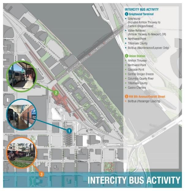
15Greyhound Terminal
Portland’s Greyhound Terminal is located just south of Union Station on a double
block between NW Irving and NW Glisan Streets, and NW 5th and 6th Avenues. This
is the also the northern terminus of the TriMet Transit Mall, and MAX light rail and
bus stops are located to the east and west of the station. The station is operated on
a agency model with a local management firm under contract to Greyhound.
The Greyhound terminal houses passenger ticketing and waiting room functions, a
Package Express office, maintenance, crew, and administrative facilities, as well as a
restaurant/snack bar. A driver dormitory serves bus divers lodging in Portland for
short stays.
Approximately 20 weekday arrivals and departures service the Greyhound Terminal
each weekday. Routes currently serve Seattle and points north, Boise/Eastern
Oregon and points east, and Eugene/Medford, OR and Redding OR and points
south. Northwest POINT, Valley Retriever, and Tillamook County Transportation Greyhound Terminal
District services also stop at the Greyhound Terminal. Additionally, Job Corps and
charter buses occasionally use the Greyhound facility.
The terminal is open daily from 5:30am - 11:30pm, and closes each day between
1:00 - 3:00pm due to a lack of bus activity and to reduce costs.
All maintenance and fueling activities occur on site at the station. A 15,000-gallon
buried fuel tank currently exists at the site to serve this function. According to the
station manager, up to 18 vehicles can overnight at the station.
The Greyhound facility is also used for bus layover, fueling, and maintenance for
BoltBus, which is under the ownership of Greyhound but does not use the terminal
for passenger boarding and alighting.
While the Amtrak and Greyhound networks include significant overlap, and
therefore can be viewed as competitive, the redundancy and capacity of rail and Greyhound Passenger Concourse
bus services can be valuable during peak travel periods or events affecting the
highway or rail networks (e.g. landslides or floods).
16Greyhound Terminal
The existing Greyhound Terminal is considerably larger than required
to meet Greyhound’s capacity requirements for its current and
anticipated future operations. Currently, Greyhound anticipates a
future need for 4 bus bays and a 2,500 sf facility for passenger,
ticketing, package express, and support functions.
As a result, there have been discussions in recent years about
downsizing the facility to align with current and future needs. Other
changes to the facility, such as combining passenger ticketing and
Package Express into one service counter, would increase the
efficiency of operations.
Future facility location and design could involve a re-assessment of
whether maintenance, fueling, and cleaning activities are done on site
or at a remote facility – a model that is used in Seattle.
Greyhound Terminal
Greyhound baggage and Package Express room BoltBus layover at Greyhound Terminal
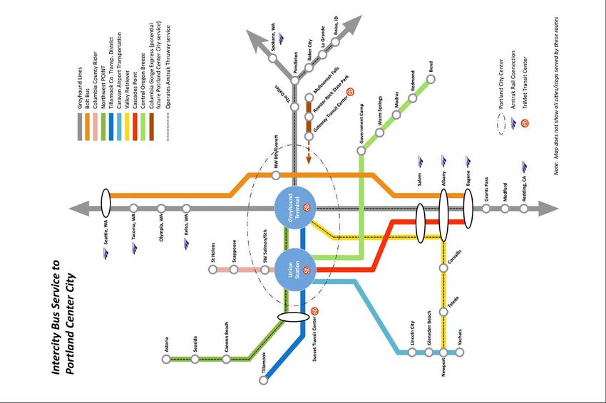
17Intercity Bus Services
Together, Union Station and the Greyhound Terminal serve as the hub for
Portland’s intercity bus network. These services connect the Portland region
with other cities in Oregon, Washington, Idaho, California, and beyond.
The intercity bus network is highly fragmented, with multiple public and
private operators running independent services (see map, next page). The
Oregon Department of Transportation’s Public Transportation Division
coordinates a number of statewide services and publishes a consolidated
timetable for many operators.
Intercity bus services use either Union Station or Greyhound as their central
Portland passenger station or terminus location. A few services stop at both
terminals.
Amtrak Thruway buses also are split between the two facilities, though most
terminate at Union Station to facilitate passenger/baggage transfers and
customer service. The Portland-Boise route (via eastern Oregon) is operated
by Greyhound and co-marketed with Amtrak as a Thruway route. Unlike other
Thruway services, the Boise service departs from the Greyhound Terminal.
Passenger loading
Ridership data on many privately-operated services is considered proprietary;
data on ODOT POINT services operating to Union Station are shown in the
table below.
Intercity Bus Service Annual Ridership (2015)
Cascades POINT 91,529
(supplementing Amtrak
Cascades rail service)
NorthWest POINT 23,765
(between Astoria and Portland)
Source: ODOT Public Transportation Division
Union Station bus loading and layover area
18Intercity Bus Services
19Intercity Bus Terminals – Union Station Vicinity
The diagram to the right illustrates the three intercity
bus terminal locations in the vicinity of Union Station,
including the services that operate at each location.
Note that a few services (Northwest POINT and
Tillamook County) serve both the Union Station and
Greyhound facilities.
Unlike some cities, there is not a consolidated intercity
bus terminal for the convenience of arriving,
departing, and connecting passengers. This is
indicative of the current fragmented nature of public
and private intercity bus services operating near Union
Station.
Intercity bus signage and schedules at Union Station
20BoltBus
BoltBus operates non-stop intercity bus service between Portland and
Seattle. BoltBus is owned by the Greyhound Lines, but is operated
and marketed independently. The exception is that BoltBus
maintenance, fueling, and layover occur at the Greyhound Terminal as
described previously.
BoltBus passenger boarding and alighting occurs at an on-street
location on NW Everett Street between NW Broadway and NW 8th
Avenue, in the Pearl District a few blocks from both the Greyhound
Terminal and Union Station. Formerly, the BoltBus stop was located
on SW Columbia Street in the heart of the Central Business District.
Three BoltBus vehicles can berth at the NW Everett Street location at a
given time, which is also shared with a TriMet bus stop. A designated
taxi stand and BIKETOWN bikeshare rack are also located nearby.
Ticketing and baggage services are conducted by BoltBus coach
operators when the coach is berthed at the stop.
While this non-terminal operation is consistent with Boltbus operation
in some other markets, there are drawbacks for customers such as: a
lack of amenities, seating, customer service/security personnel, and
weather protection. As a result, waiting passengers, luggage, and
bicycles are often observed in the landscaped area of the adjacent
U.S. Customs House and on the public sidewalk.
In some cities like Boston and Washington D.C., BoltBus ouperates out
of a multi-carrier intercity bus terminal alongside Greyhound and
other common carriers.
TOP: Passengers, bicycles, and luggage in Customs House
landscaped area
BOTTOM: BoltBus loading on NW Everett Street, absent
weather protection and passenger amenities
21Parking
Parking in the vicinity of Union Station is currently provided through a
mix of on-street metered parking, pay surface lots, pay parking
garages, and limited on-site employee parking.
Key existing parking facilities include: on-street metered parking along
NW Station Way and adjacent streets; the Block Y surface parking lot
(includes dedicated Wilf’s Restaurant parking); and the Station Place
garage, which can accommodate overnight parking for rail passengers.
While a full assessment of parking capacity and utilization is beyond
the scope of this study, various facilities cater to the parking needs of
overnight bus/rail passengers, commuters/employees, and short-term
visitors.
Wayfinding to Station Place garage on NW Station Way
Metered short-term parking on Station Place garage with hourly, daily, and overnight parking
NW Station Way
22Parking
In the future, a “district” approach to shared parking supply is
envisioned at Union Station and in the Broadway Corridor.
As in other parts of the Central City, buildings are not anticipated to
have dedicated parking supply, and the limited existing parking at
Union Station will be reduced in the future to only accommodate
maintenance and company-owned Amtrak rail support vehicles.
Future development of the surface lot on Block Y as a public space
would eliminate this facility from the available parking supply in the
immediate vicinity of Union Station for daily/short term visitors, and
for those who use the lot for passenger pick-up or drop-off.
Block Y surface parking lot opposite Union Station
Amtrak employee parking near Union Station Annex – Greyhound Terminal surface parking lot for customers
proposed for removal to create Annex Plaza
23Portland Streetcar
Access to and from the Portland Streetcar is currently one of the more
challenging public transit connections at Union Station. The nearest Streetcar
stations for the A Loop, B Loop, and North-South Line are located in the
vicinity of NW Lovejoy Street and NW 10th Avenue. The Post Office site,
Broadway Viaduct, and Lovejoy Ramp are significant pedestrian barriers that
also make locating a station closer to Union Station difficult.
The prospect of reconnecting NW Johnson Street as well as other pedestrian
pathways through the Post Office Site could improve the directness and
quality of Streetcar connections.
Additionally, wayfinding to/and from Union Station and the Streetcar would be
especially beneficial for arriving and departing passengers and those
Potential future connection from Streetcar and Pearl District
unfamiliar with local streets and station locations.
via NW Johnson Street extension through the Post Office Site
Existing pedestrian connection to Portland Streetcar Streetcar at NW Lovejoy Street/NW 9th Avenue –
adjacent to the Lovejoy Ramp – the isolation and lack of the closest stop to Union Station
visibility may make some pedestrians hesitant to use this 24
route, particularly at night.TriMet MAX and Bus
Union Station is conveniently located at the north end of the
Portland Transit Mall. The nearest Max light rail stations are
located adjacent to the Greyhound Terminal, between NW Irving
and Glisan Streets, on NW 6th (Southbound) and NW 5th
(North/Eastbound) Avenues. These stations are co-branded with
“Union Station” in their names. The stops are, however, not
currently well marked with wayfinding between the station and
the MAX platforms.
Similarly, a large number of TriMet bus routes also operate on the
Transit Mall. NW Glisan Street also serves Route 77 (westbound),
while Route 77 eastbound and several other routes operate on
NW Everett (continuing to the Eastside via the Steel Bridge).
MAX light rail on Transit Mall
Transit service near Union Station (source: TriMet) Transit Mall and Greyhound Terminal from Union Station, looking south
25TriMet Division Bus Rapid Transit (BRT)
TriMet’s Division Bus Rapid Transit (BRT) project is a new The intensity of bus activity and size of layover/support facilities are
proposed system connecting East and Southeast Portland expected to increase in the Union Station vicinity with the
communities and Gresham with the Portland Central City, introduction of the Division BRT.
terminating at Union Station. The project is currently in the
design phase, let by TriMet in partnership with Metro. The Based on current TriMet requirements, this will involve storage of 17
project is estimated to cost $175 million, with construction in late TriMet buses, 2 C-TRAN buses, and 1 intercity bus at the north end of
2018 and service beginning in 2021 (contingent on securing the Transit Mall/Greyhound site. Potential MAX track realignment in
construction funding). this area is also being considered.
The proposed western terminus station for the Division BRT is a The increase in service and the fact that the Division BRT terminates
single platform located at SW Irving and SW 5th Avenue, across at Union Station create a need for new layover and operational
the street from Union Station itself. support facilities in the vicinity of Union Station, as is discussed in
the following section.
Division BRT alignment and stations, showing NW Irving/NW 5th Avenue terminus near Union Station (source: TriMet)
26TriMet Operations and Layover
NW Irving Street, adjacent to Union Station, represents the northern end of
the Portland Transit Mall. From this location, bus and MAX routes diverge
across the city, including Eastside MAX connections via the Steel Bridge.
Additionally, a light rail and bus layover with operator facilities is located in a
triangular wedge of land just east of NW 5th Avenue. This provides staging
and layover area for buses and trains as they enter and exit service on the
mall.
As land use changes and development intensifies in the vicinity of Union
Station, a key issue will be balancing TriMet’s operational need with the
needs and opportunities of the emerging Broadway Corridor community.
New bus/light rail facilities have the potential to impact development
decisions at a redeveloped Greyhound Terminal site, Union Station
(specifically, the Annex and proposed Annex Plaza), and other key
development parcels such as Block R. Therefore the location and design of
these essential facilities requires careful consideration of the surrounding
urban context and development objectives.
An interim layover facility for the Division BRT has been proposed for NW
Station Way. This facility would be location north of NW Lovejoy Street
viaduct, adjacent to the Union Station tracks and fence on the east side of the
street. Vehicles will enter and exit service from the layover facility via NW
Station Way, traveling past the front entrance of Union Station.
Potential impacts of this proposed temporary Division BRT layover on traffic,
passenger pickup/drop-off, and pedestrian movement along NW Station Way,
Union Station, and future public spaces in front of Union Station should be
considered carefully in future design decisions.
TOP: TriMet layover from near Union Station Annex
BOTTOM: Aerial View of TriMet layover facility
27Pedestrian Environment and Wayfinding
By virtue of its Central City location, Union Station is in a highly walkable
environment. However, the specific location of Union Station, between the Post
Office Site, Broadway Bridge, and the railroad tracks, introduce pedestrian
barriers that are atypical of most of the Central City.
For passengers traveling to and from Union Station, the current lack of wayfinding
of and from adjacent neighborhoods and transit stops is a deficiency. This is
exacerbated by the current pedestrian barriers (Post Office Site, railroad tracks,
Broadway Viaduct, etc.) that impair direct routing and line of sight to key
destinations.
The underside of the Broadway Viaduct (NW Station Way) is an important
pedestrian connection to the Station Place Garage and the Pearl District. However
existing lighting and sidewalk conditions are poor, and this area is prone to
vagrancy and camping activity. Additionally, the pedestrian path along the north
edge of Union Station through the current bus loading, freight, and maintenance
area is not well defined nor ADA accessible.
Community concerns have also been expressed about pedestrian/bicycle crossing
safety at the NW 9th Avenue at-grade rail crossing, which experiences a high
volume of passenger and freight traffic.
To the south, loitering and camping activity can create an uncomfortable
environment for pedestrians walking south towards the Transit Mall and the
Central Business District along SW 5th and 6th Avenues.
There are key opportunities to improve pedestrian connectivity through future
proposed improvements, most notably the extension of NW Johnson Street
through the Post Office Site to the front of Union Station, and the Green Loop
project.
TOP: Potential future extension of NW Johnson Street through Post Office Site
BOTTOM: Existing pedestrian environment under Broadway Viaduct
between Union Station and Station Place parking garage
28Bicycling Network and Facilities
Bicycle connectivity to, and through, the Union Station vicinity is an important
aspect of the multi-modal transportation network. Union Station is the front
door for cyclists arriving to and from the city via rail and intercity bus services.
The Amtrak Cascades service features a roll-aboard bicycle baggage car that
does not require disassembly and boxing of bicycles as required on most other
trains and buses. It is therefore possible to roll a bicycle directly from the
Cascades train on train platform, through the Main Concourse of Union
Station, and into the surrounding city cycling network. Departing passengers
can wait with their bicycles inside the Main Concourse.
The overall vision of the future of cycling facilities and policy is provided in the
City of Portland’s Bicycle Plan for 2035 (currently being developed to the
existing 2030 plan). It envisions NW 2nd and 3rd Avenues as key north-south
bicycle connections to the area, and NW Flanders and possibly NW Glisan
Streets and east-west connections. However, specific connections north of
NW Flanders Street and west of NW Broadway into the heart of Union Station
are currently not well defined.
There are not currently designated bicycle facilities on NW Station Way
immediately adjacent to Union Station. Furthermore the density of transit
activity and MAX track work to the south of the station complicate
connections.
Bicycle parking at Union Station itself is currently provided through a covered,
outdoor bicycle rack near the front entrance of the station. Future
enhancements such as secure indoor bicycle storage for tenants are under
consideration as part of future improvements to the station.
TOP: Amtrak Cascades roll-aboard bicycle service
BOTTOM: Bicycle rack at Union Station
29Bikeshare and the Green Loop
In 2016, a BIKETOWN bikeshare station was installed immediately adjacent to the Union
Station forecourt on NW Station Way, in the location of a former on-street parking stall.
This provides a convenient bikeshare opportunity for passengers, visitors, and
employees arriving and departing the station.
The Green Loop, envisioned in the Central City 2035 Plan, is a linear park and
multimodal bicycle and pedestrian connection that connects the Central City on both
sides of the Willamette River.
Near Union Station, the Green Loop would cross the Broadway Bridge and descend
through a new, sloped bicycle/pedestrian connection into the redeveloped Post Office
Site. This would enable a connection directly to Union Station in the vicinity of an
extended NW Johnson Street. From here, the Green Loop continues south via the North
Park Blocks (NW 8th Avenue and NW Park Avenue).
The construction of the Green Loop has the potential to be a transformative investment
for pedestrian and bicycle connectivity to and from Union Station. BIKETOWN bike sharing on NW Station Way
Green Loop concept (City of Portland) Recumbent cyclist in Union Station driveway
304. Union Station Driveway
Union Station Driveway Operations
The driveway of Union Station supports a wide variety of transportation
activity to provide sufficient passenger, tenant, visitor, and freight access to
the station. The driveway is approximately triangular in shape, formed by the
outline of former segments of NW 6th Avenue and NW Johnson Street
(replaced by NW Station Way).

Activity in the Union Station Driveway includes:

• Passenger drop-off/pick up (private auto)

• Taxi drop-off/pickup (including dedicated taxi stand)

• Transportation Network Company/Rideshare drop-off/pickup

• Paratransit drop-off/pickup (including dedicated handicap loading zone)

• Amtrak Thruway/Intercity Bus passenger loading and layover                                 Driveway activity during train arrival

• Building/tenant freight deliveries

• Amtrak package/freight delivery and pick-up

• Emergency vehicle access

                                                                                   Tillamook County bus loading at Union Station

                                                                                                                                  32
Union Station Driveway Operations
33Driveway Configuration and Curb Allocation
The driveway at Union Station consists of three lanes for vehicle stopping,
storage, and circulation. Lane use and restrictions are conveyed through
pavement markings and signage. Compliance can be problematic due to
congestion and driver unfamiliarity with the facility.
The north end of the driveway is marked for buses only through a large
yellow stripe and wording painted on the asphalt. Some drivers, however,
disregard this signage and enter the bus zone for passenger loading or to
exit the station.
While the driveway is marked with signs and painted arrows for one-way
operations, buses are sometimes observed entering through the one-way
exit in order to bypass congestion in the main passenger loading area.
Additionally, buses are required to make a sharp (more than 90-degree) left
turn upon exiting the driveway at the north end in order to access NW Driveway with signage and lane markings
Irving Street and NW Broadway.
Buses sometimes enter the driveway exit in the opposite Pavement stripe designating BUS ONLY zone in north driveway
direction to avoid driveway congestion
34Passenger Pick-Up and Drop-Off
Passenger pick-up and drop-off is characterized by bursts of vehicle and pedestrian activity
prior to train departures and following arrivals. Intermediate periods are relatively quiet.
Private auto pick-up and drop-off occurs in a designated area immediately in front of the main
entrance to the station. Relative to the size of the taxi stand and bus/freight areas, this
represents a relatively small portion of the available curb space. As a result, significant
driveway congestion can occur in the peak minutes of passenger loading and unloading
activity.
NW Station Way travel lanes and parking spots sometimes provide a spillover for auto waiting
and passenger loading during times of peak congestion in the driveway.
Vehicle loading capacity is also reduced due to crossway delays from pedestrians and cyclists
existing the station and crossing the driveway towards the forecourt.
NW Station Way activity during train arrival
BOTTOM ROW: Passenger pick-up and drop-off
35Taxi Loading and Queuing
Approximately half of the main driveway at Union Station curb,
including two lanes, are dedicated to taxi loading and quieting.
This is a relatively large allotment given the relative volumes of
taxi loadings/unloadings compared to private and Transportation
Network Company departures.
Still, at times, the taxi queue fills to capacity, and the metered
parking spaces on NW Station Way southbound serve as an ad
hoc taxi queue overflow.
ABOVE: Taxi queue and designated (yellow) curb
TOP RIGHT: Taxi queue spillover into metered parking on SW Station Way
BOTTOM RIGHT: Taxi loading area
36Transportation Network Companies (Rideshare)
Mirroring trends across the City of Portland, the emergence of Transportation
Network Companies (TNCs) or rideshare such as Lyft and Uber in recent years
have had a significant impact on transportation mode share at Union Station.
In spite of this shift in travel behavior, no physical accommodations, signage,
or wayfinding has been provided at Union Station to allocate curb space to
this function or to notify passengers of TNC pick-up locations. This is in
contrast to, for example, Portland International Airport, which has designated
a portion of the arrivals curb to TNC services and has incorporated this mode
into airport wayfinding.
The current curb allocation, and the competition for curb space between TNCs
and private autos, contributes to congestion in the driveway during peak train
arrival and departure periods.
TOP RIGHT: Transportation
Network Company designated
loading zone at Portland
International Airport
BOTTOM ROW: Transportation
Network Companies pick-up and
drop-off at Union Station
37Accessibility
Substantial improvements have been made in recent years to enhance
accessibility of Union Station and vicinity. Future improvements inside Union
Station itself will remove remaining barriers to travel for rail passengers,
tenants, employees, and visitors to the building, e.g. through elevator and
platform upgrades.
Outside of Union Station, there are designated accessible parking spaces and
a handicap loading zone in the driveway, closest to the main entrance of the
station. TriMet also provides paratransit pick-up and drop-off at the front
curb.
Most area curbs and sidewalks have been upgraded with ADA ramps and
accessibility features, through a few barriers remain, notably the northern
front curb of Union Station beyond the bus loading area.
TriMet paratransit loading at front curb
Handicapped parking stall Power-assisted station entrance door Accessible sidewalks on Transit Mall
38Deliveries and Emergency Access
Building deliveries such as USPS mail service, concession supplies, and other
delivery services (e.g. FedEx) occur via the Union Station driveway. These
deliveries generally share the same small portion of the driveway used for
auto passenger pick-up and drop off, but often occur at less congested times
of the day.
Deliveries are offloaded at the front curb and are transferred into the building
(e.g by handcart) through the main entrance. Delivery vehicles are also
observed in the bus loading area and the Amtrak Package Express loading
area on the north side of the station at times.
Trash/refuse collection for Amtrak and tenants occurs at other locations on
the north and south ends of the building, away from the driveway.
Emergency response vehicles for both building and onboard train
emergencies access Union Station primarily through the driveway and the
Delivery vehicle on sidewall at north end of driveway
main front entrance of the station.
Emergency response at Union Station Delivery at front entrance
39Intercity Bus Loading and Layover
The northern portion of the Union Station driveway, marked for buses only, is
the primarily loading location for Amtrak Thruway and other intercity
common carriers serving Union Station. The location is marked with a variety
of bus stop signs and schedules form individual carriers, as well as wayfinding
signage and information inside the terminal for the benefit of passengers.
One coach can load at the covered Union Station curb at a time. Coaches
often lay over on the opposite, outside curb of the driveway.
Intercity bus lines service Union Station through informal agreement, and
drivers to not have access to Amtrak offices or facilities. The public Main
Concourse, concession, and restrooms however are used by bus drivers
during break times as well as by waiting bus passengers.
Amtrak station staff sometimes provide information to bus passengers, but Amtrak electric cart assist –
are not responsible for intercity carrier customer service or ticket sales (with Thruway/rail passenger and baggage transfer
the exception of official Amtrak Thruway services).
Amtrak provides baggage transfer and electric cart assist service for
passengers transferring between Amtrak Thruway coaches and trains.
Electric carts access the bus loading area through the adjacent Amtrak
Package Express door that leads to the baggage room and the rail platforms.
Bus layover
Bus loading curb (left) and layover (right)
40Amtrak Package Express
North of the bus loading area on the Union Station driveway is the pick up and
drop off area for Amtrak Package Express service.
This area is the primary access for commercial freight companies and public
customers to deliver and received packages using this service. Packages can
be as large as pallet size, and therefore require access by delivery trucks and
forklifts.
Shifting the Package Express access and loading area to a more northerly,
currently unused door, is under consideration to increase available bus loading
area.
A key conflict in the existing arrangement is between freight activity and
pedestrian connections between the station main entrance and NW Station
Way in the direction of the Station Place garage. This sidewalk is also narrow
and is not equipped with ADA ramps. As a result, pedestrians are often
Amtrak Package Express loading area
observed waking in the driveway among delivery vehicles and buses to access (showing freight pallet on sidewalk)
the station.
North driveway Amtrak Package Express and Pedestrian connection through Package Express loading area
bus loading curb with signage from various service providers
41Driveway Operations – Future Considerations
The driveway of Union Station is a critical ‘front door’ to the multimodal
transportation facility– both for passengers and operations support activities like
freight delivery and emergency access.
At the same time, this area is a focal point of the Broadway Corridor for future
evolution into an urban place that creates new connections between the Post
Office site, the Waterfront, Old Town/Chinatown, and the Transit Mall.
Balancing the complex, and sometimes conflicting, objectives of station access
and urban redevelopment in this area will required careful consideration of both
transportation and urban design aspects of this issue. Future considerations
should include:
• Reallocation of driveway and curb capacity in alignment with current and
future arrival and departure modes and passenger demand. Toronto Union Station is an example of a facility that uses design
cues to provide balanced, multimodal access while enhancing the
• Improved separation of bus loading, freight, delivery, pedestrian, and bicycle urban environment of this prominent transportation gateway.
access in the north driveway area.
• Improved and intuitive pedestrian connections and between Union Station and
the Transit Mall, Station Place parking garage, and surrounding urban districts
(including the future Post Office redevelopment).
• Balance station access needs with activation of the proposed Union Station
public plaza and reactivated edges of adjacent properties.
• Impacts of the proposed TriMet Division BRT interim layover facility located on
NW Station Way, and the resultant additional vehicular traffic, on driveway
operations and pedestrian movement in the area.
Thoughtful design could address operational and safety issues
resulting from the informal and conflicting uses of the north
driveway area, including bus loading, freight deliveries,
pedestrian/bicycle access, and passenger loading activity. 425. Future Design Considerations
Future Design Considerations

For much of the 20th century, Union Station and environs peripheral to the
Central City, surrounded by rail yards and industrial land uses. More
recent development, as well as the Framework Plan vision for the
Broadway Corridor, suggests a future where Union Station is a focal point
of an emerging urban, mixed-use, and high density neighborhood.

At the same time, the area retains the essential regional transportation
function it has performed for over 120 years.

While a comprehensive urban design analysis is beyond the scope of this
study, this section introduces some of the key urban design issues and
opportunities that may emerge as the neighborhood balances these
transportation and urban development objectives.                                                   New high-density development, such as the Bud Clark Commons (left) and
                                                                                             Multnomah County Health Department facility (under construction), are altering the
                                                                                                       once utilitarian transportation land uses in the vicinity of Union Station.

            Balancing essential transportation infrastructure and neighborhood                   Curb cuts provide access to off-street bus facilities at Union Station, the TriMet
            redevelopment is creating new opportunities and challenges in the Broadway      layover facility, and the Greyhound Terminal (shown); however these driveways also
            Corridor.                                                                                            interrupt the street wall and create mid-block pedestrian conflicts.

                                                                                                                                                                         44
Future Design Considerations
Transportation Issues
Union Station – Multimodal Access/
A
Driveway Reconfiguration
B Greyhound Terminal Relocation
H
Station C Thruway/Intercity Bus Accommodations
Place D D Rail Passenger/District Parking Strategy
Garage
G E Support TriMet Layover/Operations
7
F Transit Mall Access; Proposed
Division BRT Station/Layover
Union G Access to Portland Streetcar
C Station
USPS
H Interim Proposed Division BRT
Site
Layover – NW Station Way
A
2 3 Design Considerations
Block 1
Y 1 Union Station Plaza and Edge
Activation
F
2 USPS Site Connections; NW
Grey- Johnson St. Extension; Green
E Loop
hound
3 Waterfront Pedestrian Connection
Block B
R 4 Greyhound Site – Mixed-Use
5 4
Redevelopment
6
5 Mixed-Use Infill, Including Block R
NW Glisan St.
NW Glisan St. – Edge
6
Activation/Pedestrian Corridor
NW Station Way – Pedestrian
7
Corridor Improvements under Viaduct
Key Street Edge Key Ped/Bike Connection
45Union Station Plaza
Both the Broadway Corridor Framework Plan and the Union Station PE/NEPA
study propose a future public plaza/open space at Union Station straddling NW
Station Way, encompassing both Block Y and the landscaped area south of Union
Station near the Annex building. This plaza would form a community focal point,
reactivating and integrating urban redevelopment between the Post Office Site, Bud Clark
Old Town/Chinatown, and Union Station.
Commons Post Office
New high density developments, including the Post Office Site, Bud Clark Site
Commons, Multnomah County Health Department, and potential Greyhound
Terminal Redevelopment, would frame this plaza, dramatically altering the
appearance and urban context seen today.
Block Y
There are many precedents for train station plazas in North America and Europe
that create successful urban spaces. Creating a vibrant and functional Union
Station Plaza will require balancing multimodal access, pedestrian character and
accessibility, activated edges of adjacent land development, quality design
elements, and curated programming to draw nearby residents and visitors.
Bud Clark
Mult. Co. Commons
Greyhound Health
HQ
Annex Plaza Block Y
Rendering of a future public plaza at Union Station (source:
Broadway Corridor Framework Plan)
46NW Station Way - North of Union Station
The portion of NW Station Way north of the Union Station terminal follows the
edge of the tracks and platforms towards a junction with NW 9th Ave. For a
portion of this length, NW Station Way is located under the Broadway Viaduct,
between the maintenance area of Union Station and the Post Office Site. While
this is a key pedestrian connection to the Station Place Garage (which allows
overnight parking for rail passengers) and the Pearl District beyond, it can be
an intimidating and unpleasant environment, particularly at night.
In the future, this area will continue to serve an important rail
operations/maintenance function for Union Station (e.g. train fueling, refuse
removal). However with the redevelopment of the station and the Post Office
facilities flanking each side of the viaduct, there is a unique opportunity to
reimagine and improve this corridor for pedestrians.
Another consideration for future design is the proposed location of an interim
TriMet Division Bus Rapid Transit layover facility along the east side of NW
Station Way north of the station. This facility could have pedestrian and traffic
impacts both the viaduct corridor as well as the Union Station driveway/plaza
area to the south. NW Station Way under
the Broadway Viaduct is
a key pedestrian
connection to the Station
Place Garage (left) and
the Pearl District, though
it can be an intimidating
environment for
pedestrians
Proposed TriMet Division
BRT layover area,
NW Station Way
47NW Glisan Street Corridor
NW Glisan Street is a key connection in the Broadway Corridor, as one of the few
contiguous east-west connections between the Pearl District and the
waterfront/NW Naito Parkway. It defines the southern edge of the triangle of
redevelopment in the Broadway Corridor encompassing Union Station and the
Post Office Site.
The NW Glisan Street corridor provides an opportunity for a multimodal
connection between Old Town/Chinatown with the emerging redevelopment
surrounding Union Station to the north.
Today, a number of pedestrian barriers and inactive uses pose challenges for
reactivating the NW Glisan corridor. Surface parking, vacant or underutilized
parcels, and lack of street-level activation degrade the vitality of this street. The
southern edge of the Greyhound terminal along Glisan Street, with a wide curb Surface parking lots and underutilized parcels contribute to an austere
cut for bus egress from the loading/maintenance area, contributes to challenge. pedestrian environment along NW Glisan St.
between NW Broadway and the Steel Bridge
Sensitive streetscape design and street-level activation of key redevelopment
parcels, including Block R, can help to re-activate NW Glisan St. Additionally,
redevelopment of the Greyhound Terminal, particularly if it continues to house
off-street transportation terminal facilities, should consider the potential positive
and negative impacts on the NW Glisan St. edge, as well as the other strategic
block faces on each side of the Greyhound facility.
Greyhound Terminal vehicle
egress (along NW Glisan St.
between NW 5th and 6th Avenues) Strengthening the street frontage along SW Glisan Street and
provides an inactive edge and other streets impacted by large curb cuts, surface parking, and
pedestrian-vehicle conflicts at the transportation terminals will support redevelopment of adjacent
curb cut. properties
486. Greyhound Precedents
Greyhound Terminal - Precedents
As discussed earlier in this document, the existing Greyhound
Terminal has significant surplus capacity over current and
projected future service requirements. There is also an
opportunity to redevelop the existing Greyhound facility to
support mixed use development, potentially in combination with
a reduced-scale Greyhound facility and/or layover and support
facilities for the proposed Division BRT.

This section presents design precedents from other Greyhound
facilities around the U.S. to help inform the decision about
Greyhound redesign and relocation design decisions.

There is a strong desire by the City to maintain Greyhound
terminal in the vicinity of Union Station to preserve multi-modal
connectivity and access to the transit services within the Central
City. Given the densification of the Union Station vicinity and the
available land parcels, there is a potential that a future
                                                                                                                      Existing Greyhound Terminal
Greyhound terminal could be co-located with other uses in a
multi-story structure.                                                    In Portland, the Amtrak and Greyhound facilities are currently
                                                                          adjacent within the Center City. In some other cities, these
Another future consideration for the programing, location, and            facilities are combined (e.g. Anaheim) or are even in entirely
design of the future Greyhound terminal is the accommodation              separate areas (e.g. Denver).
of other intercity bus services, such as POINT or BoltBus, in the
new facility, at Union Station, or in another location. Currently         Some cities, such as Seattle and Sacramento, have relocated
these services are divided between the Greyhound Terminal and             Greyhound facilities to CBD fringe locations where land costs and
Union Station, and involve a number of independent operators.             densities are lower. These locations are still transit accessible (by
In the interest of statewide intercity bus connectivity, which relies     nearly LRT stations in both cases), but are in locations where
on Union Station area as a de facto hub, inter-line connectivity          single story, stand alone facilities are more economical to
should be maintained or enhanced in the future through the                construct. The tradeoff is less convenience for arriving and
planning, design, and location of future facilities.                      separating passengers, and lower direct multi-modal connectivity.
                                                                          Note that Sacramento is studying the possibility to relocate
The table on the following page illustrates common                        Greyhound to a new multimodal facility at the Sacramento Valley
configurations of intercity bus and rail facilities in major cities.      Station (Amtrak station) if funding permits.

                                                                                                                                                50
You can also read