Urban design + landscape report 2021 - CROMWELL | CENTRAL OTAGO - EPA NZ
←
→
Page content transcription
If your browser does not render page correctly, please read the page content below
urban design + landscape report 2021
        CROMWE LL | CE NTRAL O TAGO
CONTENTS

INTRODUCTION + PROJECT TEAM			                                     3

SURROUNDING CONTEXT AND SITE		                                     4

         Cromwell and Surrounding Fabric			 4
         The Land / Site					5
         Spatial Context Plan				6

THE PROPOSAL					7

         Masterplan					9
         Commercial Precinct				10
         Commercial Materiality				11
         Commercial Precinct Connectivity			12
         Open Space Plan					13
         Site Connectivity					14
         Context Connectivity and Public Access		  15
         Planting Palette					16
         Northern Boundary Residential Treatment		 17
         The Existing Wooing Tree Overlay			       18
         Site Densities					19

Document Reference for Citation:
Baxter Design, 2020. Wooing Tree Estate Urban Design Report by Baxter Design for Veros Property Services.

PREPARED BY:				Baxter Design

REVIEWED BY:				Paddy Baxter
					Landscape Architect | Director
					NZILA Registered
					Baxter Design

					Revision / version: [Rev H]				Issue date: 26 - Mar - 2021

File and Project Reference: 2953 - Wooing Tree - Urban Design Report 2021 Rev H

       WOOING TREE ESTATE | URBAN DESIGN + LANDSCAPE REPORT                                                 2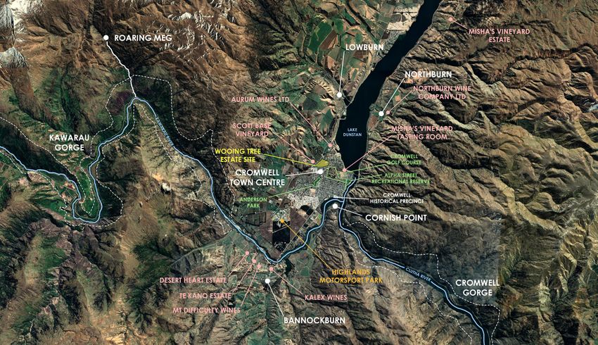
INTRODUCTION
PROJECT TEAM

Baxter Design (BD)                              Paterson Pitts Group (PPG):                      Architecture Fabian Douglas and Associates
Wooing Tree Estate Master Planning, Urban       Wooing Tree Estate Surveying, Engineering &      (F+D=A):
Design & Landscape                              Consenting                                       Wooing Tree Estate Retail and Commercial
                                                                                                 Planning and Design
Baxter Design is team of landscape architects   Paterson Pitts offers a range of professional
involved with many high profile projects        services and expertise across six offices        F+D=A’s commercial planning strategies
throughout the Southern Lakes region, Central   throughout Canterbury and Otago in               are grounded in a sound understanding
Otago and other main centres throughout         Christchurch, Dunedin, Alexandra, Cromwell,      of retail dynamics theory to determine the
New Zealand. Our extensive portfolio of         Queenstown and Wanaka.                           best master planning option, circulation and
work covers urban and rural landscape                                                            flow, maximising functionality. Our extensive
masterplanning, resort development, public      Paterson Pitts has a broad and long-standing     experience of individual tenancy fitouts
streetscape and parks, rural subdivision,       base of professional experience and have         ensures that our design decisions at a macro
residential design and landscape assessment.    an extensive understanding of the relevant       level are responsive to the needs of the
                                                district and regional plans, bylaws, policies    individual retailer.
                                                and procedural requirements of the various
                                                councils of Otago, Canterbury and Southland.

STAGE 1 AREA                                                           WOOING TREE CELLAR DOOR

      WOOING TREE ESTATE | URBAN DESIGN + LANDSCAPE REPORT                                                                                       3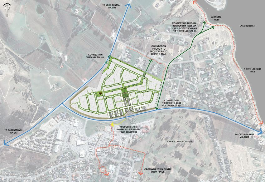
SURROUNDING CONTEXT & SITE
HISTORIC CROMWELL TOWNSHIP
CROMWELL TOWNSHIP AND SURROUNDING CONTEXT (BASE IMAGE SOURCE: GOOGLE EARTH)
HISTORIC CROMWELL TOWNSHIP
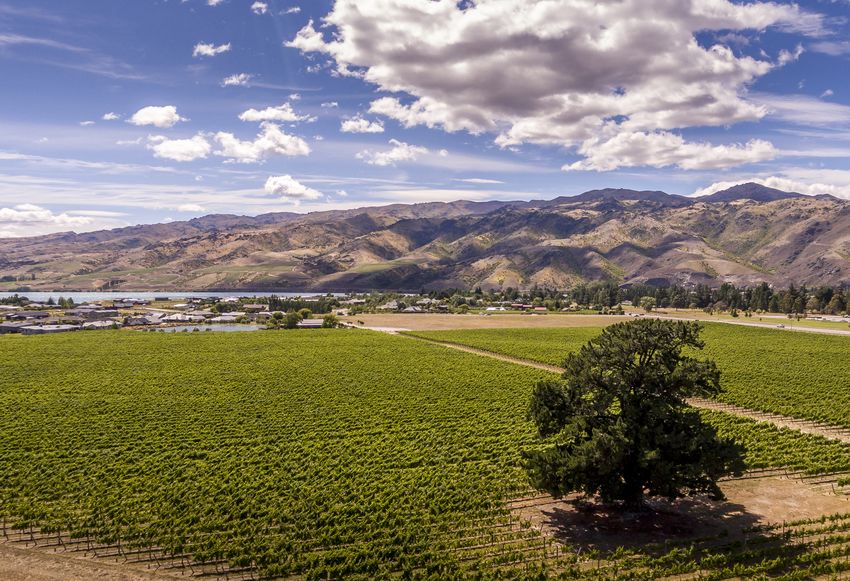
CROMWELL AND SURROUNDING FABRIC Cromwell has transitioned into a town not only State Highway 6 passes Cromwell on the
rich in its gold mining history but known for its west, linking the town to Queenstown and the
Cromwell is a bustling small town at the stone fruit, and wineries with 70% of Otago’s West Coast, with SH8B running through the
crossroads of the Clutha and Kawarau rivers. vineyards found within the Cromwell basin. town and connecting SH6 to SH8 to the east,
With a history of gold mining surrounding the which runs to Dunedin and the East Coast.
district and in the town itself, Cromwell has an Cromwell occupies the valley floor at the
eclectic yet balanced look about the town southern end of Lake Dunstan with an open The proposed Wooing Tree development is
with the historic gold mining precinct, and the aspect up the valley to the north. The town located across SH8B approximately 500m to
‘new’ town with shopping, restaurants, and is flanked by the Pisa Ranges to the west, the north of the existing town centre. The two
visitor accommodation taking advantage Dunstan Mountains to the east, running along will be linked by an underpass for pedestrians
of the pristine Lake Dunstan and surrounding a north-south axis, and contained by Carrick and cyclists, allowing easy, safe travel
areas. Range and Cairnmuir Mountains to the south. between both retail areas and beyond.
The Kawarau flows into Lake Dunstan
which is drained by the Clutha River.
CROMWELL ‘BIG FRUIT’ SCULPTURE
WOOING TREE ESTATE | URBAN DESIGN + LANDSCAPE REPORT 4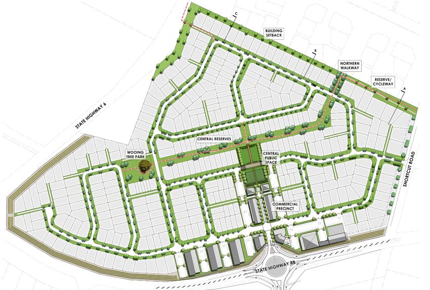
THE LAND / SITE

                                                                                                   The Wooing Tree Estate site is approximately
                                                                                                   25.4 ha in size.

                                                                                                   The site is framed by SH6, SH8B, and Shortcut
                                                                                                   Rd, and situated adjacent to the Cromwell
                                                                                                   Town Centre. The site currently operates as
                                                                                                   the Wooing Tree Vineyard and Cellar door.

                                                                                                   An existing road enters from the east of the
                                                                                                   site via Shortcut Rd, where the Wooing Tree
                                                                                                   cellar door is located.

                                                                                                   The site itself is still active as a working
CROMWELL TOWN CENTRE                                 CROMWELL TOWN CENTRE   CROMWELL TOWN CENTRE   vineyard, adding an extensive winery culture
                                                                                                   and character throughout the district. The
                                                                                                   iconic Wooing Tree stands tall amongst the
                                                                                                   vines adding to the appeal of the vineyard.

                                                                                                   WOOING TREE VINEYARD SITE PHOTO

SITE AND SURROUNDING CONTEXT (BASE IMAGE SOURCE: OTAGO DAILY TIMES)                                WOOING TREE SITE PHOTO

      WOOING TREE ESTATE | URBAN DESIGN + LANDSCAPE REPORT                                                      SURROUNDING CONTEXT & SITE         5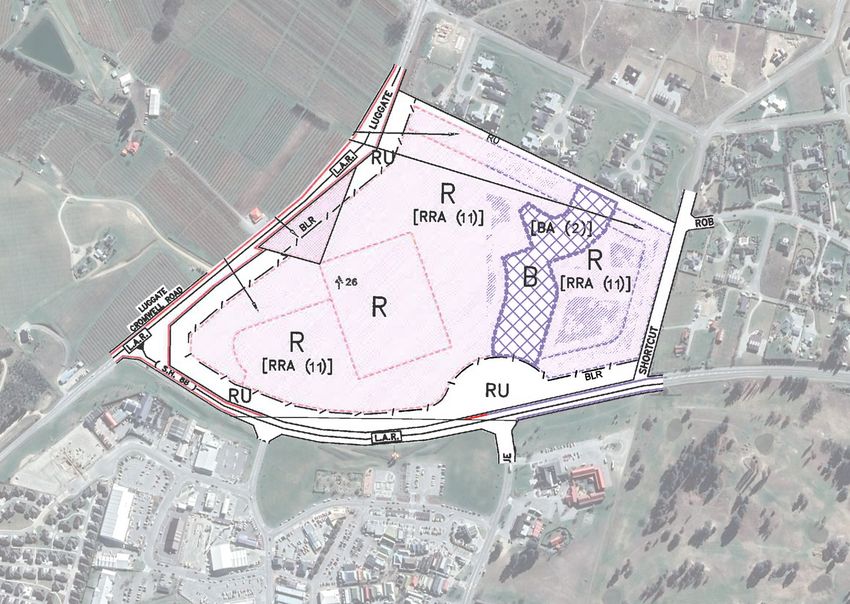
SPATIAL CONTEXT PLAN
                                                                   SPATIAL CONTEXT PLAN

                                                                   The Wooing Tree development occupies a
                                                                   unique location, nestled between existing
                                                                   established residential areas and the
                                                          400m     Cromwell Town Centre.

                                                   800m            The proposed commercial precinct is
                                                                   approximately 200 metres from the existing
                                                                   town centre, a readily walkable distance
                                                          200m     and an easily achieving walkable distance,
                                                                   promoting connectivity. Views across from
                                                                   the proposed commercial precinct and the
                                                     WOOING TREE   existing Cromwell town centre are open,
                                                     DEVELOPMENT   over council reserve, ensuring a strong visual
                                                                   connectivity.
                                                   400m
                                                                   This opportunity for connectivity is further
                                                                   enhanced by recent works undertaken by
                                                                   the Central Otago District Council on the ‘big
                                                                   fruit’ reserve south of SH8, opening up the
                                                          200m     visibility of the existing town centre from SH8
                                                   200m
                                                                   and reinforcing viewshafts between the two.

                                                                   The relatively short distance separation is seen
                                                          400m
                                                                   as a positive for both the existing Cromwell
                                                                   town centre and the proposed Wooing Tyree
                                                                   commercial precinct with the opportunity for
                                                 CROMWELL          both to reinforce and enhance commercial
                                                TOWN CENTRE
                                                                   opportunity and value

                                                                   This connectivity also expands to the north
                                                   200m            and east of the site, to Lake Dunstan and trails
                                                                   beyond

                                                          800m

                                                   400m

                                                   800m

CROMWELL TOWNSHIP 1:10,000 @A3 (BASE IMAGE SOURCE: GOOGLE EARTH)

      WOOING TREE ESTATE | URBAN DESIGN REPORT                                                                        6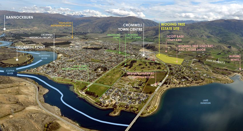
THE PROPOSAL
THE MASTERPLAN CONCEPT – WOOING TREE CONTEXT from the dam, creating Lake Dunstan. With
that came the development, in the late 1908’s
of the new town of Cromwell. The Cromwell
The Wooing Tree development is a • Adequate road widths for the Quality urban design sees buildings, places town model was based on an ‘internal’
comprehensively master planned residential provision of parking. and spaces not as isolated elements but as model of development, with parking around
neighbourhood with a commercial centre on part of the whole town or city. For example, a pedestrian accessed shopping ‘ring’. This
• A commercial area with a north model is similar to other hydro related town
land located to the north of State Highway a building is connected to its street, the street
-south aligned traditional ‘mainstreet’, projects undertaken in New Zealand in the
6 in Cromwell. The development includes to its neighbourhood, the neighbourhood
incorporating sheltered green spaces, same era, Twizel and Turangi by way of
a range of housing options / lot sizes and to its city, and the city to its region. Urban
shared pedestrian / vehicle spaces example.
a commercial area located within a well- design has a strong spatial dimension and
and a walkable scale.
planned pattern of walkways, roading and optimises relationships between buildings,
open spaces. places, spaces, activities and networks. It Cromwell’s climate is ideally suited to
also recognises that towns and cities are horticulture, with cold winters and a relatively
The principal design components of the part of a constantly evolving relationship stable hot summer, influenced by the
masterplan include: between people, land, culture and the enclosing mountain ranges and the lakes /
URBAN DESIGN OVERVIEW rivers within the valleys. Cromwell’s rainfall,
wider environment. Source: NZ Urban Design
• A 15m buffer zone located around Protocol approximately 400mm per annum, is one
the southern and western edges of of the lowest in New Zealand with seasonal
Urban Design seeks to improve townships,
the development, mostly 15m wide, The Wooing Tree site, and wider the Cromwell extremes in temperature, an outcome largely
making them more user friendly and enabling
to be planted in grapes and other urban form, are located at the confluence derived from its ‘mid-continental’ location.
connections between people and places,
appropriate vegetation. of the Clutha and Kawarau catchments,
both within the site and to adjoining existing
• Connectivity both within the site and use patterns and responding positively to flanked by the Dunstan Range to the east The Wooing Tree site is located on the north
to the existing pattern of roads and different elements and realms, for example, and the Pisa Range to the west. Historically side of State Highway 6, north of the existing
walkways in the Cromwell area public and private, social and economic, this area was known as the Junction, before Cromwell Town Centre and the iconic ‘fruit’
natural and built. These factors have a formally adopting the name of Cromwell in sculpture of Cromwell. State Highway 6 (the
• An internal roading network / pattern Luggate – Cromwell Road) flanks the western
relationship with both urban design and 1863.
that utilises two entries from Shortcut side and Shortcut Road on the eastern side,
landscape. This report includes an assessment
Road and SH6. accessing State Highway 8B. To the north
against the principals of the New Zealand Maori history in the Cromwell (Maori name:
• A cycleway / walkway underpass Urban Design Protocol and the 7 C’s in that Tirau) was largely seasonal, with Maori of the site are established rural – residential
under State Highway 6, enabling protocol. These include: occupying this area on a transitional basis, properties
connection to the park south of SH6, whilst heading further west towards pounamu
• Context The Wooing Tree site is largely surrounded
the central Cromwell commercial sources. The Cromwell area was utilised
area and beyond • Character during that travel for the harvesting of Moa, by either residential of commercial
eels and waterbirds. development and, in its current form, can
• A greenspace network within the site • Choice almost be described as an urban park, within
including a principal greenspace • Connections a developed landscape. At present the site is
Pakeha occupation began with the discovery
running west – east, aligning on the largely covered by an established vineyard.
• Creativity of gold in 1862, leading to a gold boom that
existing Wooing Tree. Within the vineyard, accessed from Shortcut
lasted into the early 1900’s, with dredging and
• Site specific design controls within the • Custodianship alluvial sluicing the principal methods utilised Road and to the north of the site, is a structure
development, acknowledging the site by the miners. with both maintenance and the current
• Collaboration
character and the visible outcome of restaurant / cellar door facilities. Adjacent to
the development. The Wooing Tree development acknowledges The demise of the gold industry paralleled a these is an irrigation pond. The Wooing Tree
and recognises its place within the wider rise in pastoralism and large-scale farming, itself, after which the vineyard is named, is a
• The location of medium to high Cromwell Township fabric and within the large mature Pinus radiata, located centrally
together with a growth in fruit production,
density residential areas in the central context of Central Otago. Within that comes a within the site. The tree is significant by way
both of which continue today. The viticultural
portion of the development, flanking responsibility to the rich history and character of the folklore attached to the tree and its
industry, now an established part of the
the commercial area. of this region and a willingness to exemplify visibility within the site. The vineyard maintains
landscape, is relatively new, beginning in the
• A well - conceived internal pattern that in design and creativity. 1990’s and replacing in part the fruit industry. a prominent reputation in regards to the
of walkway and cycleway within the wine it produces and its immediacy to the
development. Large areas of established horticulture within existing town centre, providing a pleasant
the Clutha and Kawarau River valleys were horticultural edge to SH6 within the wider
lost to the construction of the Clyde Dam and Cromwell township character.
the ensuing flooding of the valley upstream
WOOING TREE ESTATE | URBAN DESIGN REPORT 7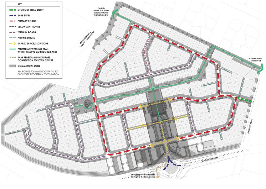
THE PROPOSAL
CHARACTER                                                                                             CREATIVITY                                         CUSTODIANSHIP

Quality urban design reflects and enhances           • The siting of the commercial precinct          Quality urban design encourages creative           Quality     urban    design    reduces       the
the distinctive character and culture of our           within walkable distance from both             and innovative approaches. Creativity adds         environmental impacts of our towns and cities
urban environment, and recognises that                 the existing Cromwell township and             richness and diversity, and turns a functional     through environmentally sustainable and
character is dynamic and evolving, not                 the Wooing Tree residential areas.             place into a memorable place. Creativity           responsive design solutions. Custodianship
static. It ensures new buildings and spaces                                                           facilitates new ways of thinking, and              recognises the lifetime costs of buildings and
                                                     • The importance of creating a
are unique, are appropriate to their location                                                         willingness to think through problems afresh,      infrastructure, and aims to hand on places
                                                       ‘mainstreet’ focussed design solution
and compliment their historic identity, adding                                                        to experiment and rewrite rules, to harness        to the next generation in as good or better
                                                       for the proposed commercial precinct
value to our towns and cities by increasing                                                           new technology, and to visualise new futures.      condition. Stewardship of our towns includes
                                                       and controls within that precinct
tourism, investment and community pride.                                                              Creative urban design supports a dynamic           the concept of kaitiakitanga. It creates
                                                       to enable regionally appropriate
(Source: NZ Urban Design Protocol)                                                                    urban cultural life and fosters strong urban       enjoyable, safe public spaces, a quality
                                                       building design with appropriate
                                                                                                      identities. (Source: NZ Urban Design Protocol)     environment that is cared for, and a sense
                                                       claddings, scale and form.
The principal urban drivers on which the                                                                                                                 of ownership and responsibility in all residents
masterplan has been developed include the                                                             The Masterplan has been developed to               and visitors. (Source: NZ Urban Design
following components:                             The above factors have been included in the         respond to the wider overriding qualities of       Protocol)
                                                  design format and layout of the masterplan.         the site specifically the need to include a
                                                  In particular, streets are largely ‘straight        substantial rural corridor and as a response
   • The specific requirements of the                                                                                                                    The matter of custodianship relates to sense
                                                  in character, enabling view shafts and              to the alignment of the surrounding State
     Wooing Tree overlay contained in the                                                                                                                of place, translating to community wellbeing
                                                  distance, similar to the stashed form of existing   Highway roading and the relationship of the
     Central Otago District Plan                                                                                                                         and health. This relates to the look and feel
                                                  Cromwell. Connections utilise this pattern to       Wooing Tree site with the existing Cromwell
   •   A requirement to deliver range of                                                                                                                 of a development. The development layout,
                                                  enable logical and obvious opportunities for        Township to the south.
       densities, with lot site sizes that will                                                                                                          controls and detailing and the urban design
                                                  pedestrian and cycle connections.
       enable an affordable range of                                                                                                                     components all collaborate to provide a
                                                                                                      Whilst the architectural controls will be strong   sense of amenity that is unique to this site.
       options for purchasers.                    The green space pattern follows the above           and fundamentally contiguous, residential
   • The ability to connect, by road              format, providing long vistas and spaces,           lot owners will be encouraged to undertake         Fundamental to this is the protection of
     cycleway and walkway, to available           avoiding small parks and promoting a central        contemporary interpretations of these forms.       cultural and heritage values, being a sense of
     networks outside of the site and the         green space of appropriate scale.
                                                                                                                                                         place. Sound design provides for this.
     establishment of a sound connective                                                              Streetscape elements will utilise regional
     network within the site.                     Site planting will represent a variety of species   materiality such as stone, steel and simple
                                                  including native plants, fruit trees which are      upright plantings, avoiding the repetitive
   • The inclusion of appropriate setbacks        iconic to the area and some deciduous trees         nature of traditional residential settlement
     from State Highway 6 and neighbours.         reflecting the character of the Central Otago       that can easily lose regional quality. This
   •   Recognition of the cultural                landscape.                                          opportunity will be especially explored within
       importance of the Wooing Tree                                                                  the commercial precinct, where architectural
       and enabling visual and physical                                                               character becomes the predominant
       connection with it.                                                                            expression of regional character, avoiding the
                                                                                                      temptation to relocate architectural elements
   •   The establishment a strong and robust
                                                                                                      from other urban centres, maintaining a
       set of design controls to enable a
                                                                                                      creative and appropriate response.
       cohesive ‘village’ neighbourhood
       to develop and the avoidance
       of ‘suburbia’, recognising the
       importance of a high - quality design
       contiguity and recognition of the
       importance of building materials
       appropriate to the rural context of the
       site.

       WOOING TREE ESTATE | URBAN DESIGN + LANDSCAPE REPORT                                                                                                                                                 8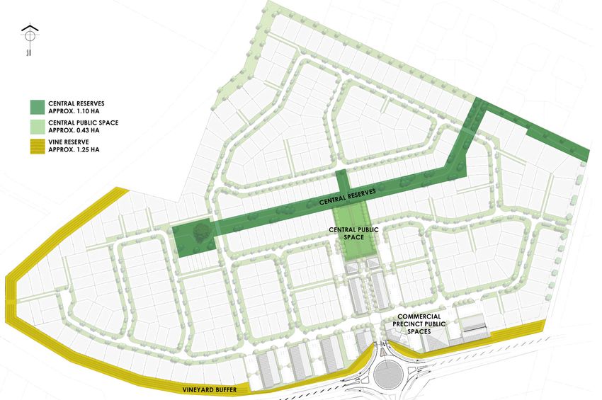
THE MASTERPLAN

WOOING TREE ESTATE MASTERPLAN SCHEME - SCALE 1: 2500 AT A3

   WOOING TREE ESTATE | URBAN DESIGN + LANDSCAPE REPORT      THE PROPOSAL   9
THE COMMERCIAL PRECINCT
COMMERCIAL PRECINCT CHARACTER

The proposed commercial precinct seeks to
re-establish a walkable mainstreet character.
Large areas will be developed as ‘shared
space’, enabling easy pedestrian access
whilst still maintaining visible shop frontages
from vehicular movement. Servicing and
carpark areas flank the east and western
edges of the mainstreet development,
providing easy access for pedestrians but
screened from mainstreet and avoiding any
denigration of mainstreet character.

To the northern end of ‘mainstreet’ are
located the central green spaces, easily
accessed from the commercial area and
offering opportunities for outside dining and
integration with commercial activity.

It is anticipated that the urban design
‘furniture’ elements will respond to the local
vernacular (and recent upgrades undertaken
in the existing Cromwell commercial area)
by way of integrating stone walls, fruit trees,
appropriate paving etc. into the design as it
progresses, acknowledging its place in the
wider Cromwell region

The commercial precinct materiality will also
respond accordingly, utilising an appropriate
palette of claddings, form and scale in keeping
with the regional character. This palette and
design will become a contemporary

The overarching ethos for the Main Street
is to create a modern reinterpretation of a
historical agricultural utilitarian vernacular.
The width of the street has been deliberately
kept to a practical minimum to provide the
maximum sense of enclosure. This reduction
has been achieved by forgoing parallel
parking and seating of typical streetscapes.
This is replaced instead with largely planting
and public seating opportunities incorporated
into the tenancy shopfronts.

                                                  COMMERCIAL AND RETAIL PRECINCT CONCEPT PLAN (SCALE 1: 1200 @ A3)
                                                  NOTE: PLAN INDICATIVE ONLY

      WOOING TREE ESTATE | URBAN DESIGN + LANDSCAPE REPORT                                                           THE PROPOSAL   10
COMMERCIAL PRECINCT MATERIALITY
COMMERCIAL PRECINCT
The overarching ethos for the Main Street is Both surmounted with a spandrel of
to create a modern reinterpretation of a corrugated iron higher on the facade.
historical agricultural utilitarian vernacular.
Further articulation is provided by slightly
The structural system; that of a rolled pipe truss moving the façade back and forward in plan
is proposed for portals and raised in aesthetic to provide shadow lines and the opportunity
status by exposing the leading edge of the for shopfront planting.
portal leg structure and the cantilevered
veranda beams on the building’s exterior. Tenant signage is envisaged as stencilled
spray paint, applied directly onto the façade.
Smart Retailing prerequisites a largely
continuous and so flexible footprint, but The width of the street has been deliberately
aesthetically, the shopfront has also been kept to a practical minimum to provide the
visually divided to match a more traditional maximum sense of enclosure. This reduction
grain of organic growth and occupation. For has been achieved by forgoing the ubiquitous
VISUALISATION OF ENTRY TO THE COMMERCIAL PRECINCT | F + D = A
this purpose, two styles of façade were used: parallel parking and street trees and seating of
typical streetscapes. This is replaced instead
• A more transparent continuous
with largely consolidated car parking on the
shopfront glassing system,
peripheral streets, vines, lower planting and
incorporating modern ‘shugg’ style
public seating opportunities incorporated
double hung windows, and second,
into the tenancy shopfronts.
• A more solid cast insitu concrete
façade with penetrating window
and doors, but again incorporating
modern ‘shugg’ style double hung
windows
VISUALISATION OF SHOP FRONTAGE FOR COMMERCIAL PRECINCT | F + D = A
(NOTE: ARCHITECTURAL IMAGES ARE INDICATIVE ONLY)
CONTEMPORARY BARN STYLE DOORS CLIMBING PLANT SPECIES ON FACADE BOARD FORM CONCRETE CLADDING CORTEN STEEL DETAILS AND BASALT SETT THRESHOLDS CROMWELL STONE GOLD/LIGHT
AND FEATURES AND DETAIL CLADDING
WOOING TREE ESTATE | URBAN DESIGN + LANDSCAPE REPORT THE PROPOSAL 11COMMERCIAL PRECINCT CONNECTIVITY
INTERNAL CONNECTIVITY PATTERNS
The proposed commercial precinct is located
around a central axis, being the mainstreet.
This is directly visible from SH6, aligning north –
south enabling visual connectivity and equal
solar gain to both flanks of the main street.
That axis continues through the masterplan
to the northern edges, allowing for a simple
pedestrian and visual connection.
The layout of this precinct allows for visibility to
the south, encouraging connectivity from the
existing Cromwell Town centre and a clearly
identifiable view shaft.
The commercial precinct is approximately
200 metres from the existing shops, a
walkable distance and easily available
to existing parking in the Cromwell Town
Centre. Importantly this connectivity has the
opportunity to energise both commercial
areas whereupon they become one, with a
green space between.
COMMERCIAL AND RETAIL PRECINCT CONNECTIVITY AND SPACES PLAN (NOT TO SCALE)
WOOING TREE ESTATE | URBAN DESIGN + LANDSCAPE REPORT THE PROPOSAL 12OPEN SPACE PLAN
OPEN SPACE PATTERNS
The open space patterns are located within
the road network with the principle green
space running west-east, from the Wooing
Tree across the full length of the development.
This provides a green space of an appropriate
scale for passive and active activities.
This central green reserve is also highly visible
from dwellings and several road connections,
alleviating CPTED issues.
Design controls ensure that all dwellings
facing the central reserve space have full
visual accessibility, with no solid fencing to
the reserve.
OPEN SPACE PLAN (SCALE 1: 3000 @ A3)
WOOING TREE ESTATE | URBAN DESIGN + LANDSCAPE REPORT THE PROPOSAL 13SITE CONNECTIVITY
URBAN DESIGN: CONNECTIONS
Walkways and Cycleways - Internal:
The proposed development will have
opportunities to connect directly to existing
trails and cycleways outside the site. A
principal linkage will be the development of
the proposed underpass under SH8B through
to the Cromwell town centre.
This underpass will be an asset for the
development, giving connection to the
proposed retail and commercial space
where the Wooing Tree Cellar door is to be
relocated. The underpass also provides safe
pedestrian movement through to the existing
retail centre.
The opportunity also exists for a linkage
through to an existing trail along Shortcut Rd,
between an existing reserve, and through to
SH6 to access the existing public infrastructure
network surrounding the township.
WAYS AND GREEN SPACE /
Connections:
Good connections enhance choice, support
social cohesion, make places lively and
safe, and facilitate contact among people.
Quality urban design recognises how all
networks - streets, railways, walking and
cycling routes, services, infrastructure, and
communication networks - connect and
support healthy neighbourhoods, towns and
cities. Places with good connections between
activities and with careful placement of
facilities benefit from reduced travel times
and lower environmental impacts. Where
physical layouts and activity patterns are
easily understood, residents and visitors can
navigate around the city easily. Source: NZ
Urban Design Protocol
INTERNAL SITE CONNECTIVITY PLAN (SCALE 1: 3000 @ A3)
WOOING TREE ESTATE | URBAN DESIGN + LANDSCAPE REPORT THE PROPOSAL 14CONTEXT CONNECTIVITY & PUBLIC ACCESS
WIDER CONNECTIVITY
External Walkways and Connectivity:
The proposed development has considered
potential linkages to the wider community
and existing trails and facilities.
To the north of the development there is
potential to create a cycle/pedestrian link to
SH6. This would allow future residents within
Wooing Tree Estate to access the wider trail
network around the Cromwell township and
out toward Lake Dunstan.
Wider Connectivity Patterns:
The Wooing Tree masterplan enables 3 levels
of connection being: within the site, to the
wider rural recreational opportunities being
Lake Dunstan and the wider trail network
(existing and currently under construction)
and to the existing Cromwell Township. These
Linkages will be developed to the wider
networks via Shortcut Road and via accesses
shown to the northwest and southwest of the
masterplan, to SH6 and SH8B. Directly south
of the proposed commercial precinct access
to the existing Cromwell Township (a distance
of approximately 250m to the northern edge
of the existing Cromwell Mall), via the existing
park surrounding the ‘fruit’, by way of an
underpass under SH6.
EXTERNAL CONNECTIVITY PLAN (NOT TO SCALE)
WOOING TREE ESTATE | URBAN DESIGN + LANDSCAPE REPORT THE PROPOSAL 15PLANTING PALETTE
PLANTING
Planting Philosophy:
Street Trees Ground Cover & Grasses
The proposed planting uses a mix of natives
and exotics which are appropriate to the dry
local climate and reference the character of
Cromwell.
Street Trees:
Upright Elm - Ulmus hollandica ‘Lobel’
Upright English Beech - Fagus sylvatica
‘Dawyck Green’
Ulmus hollandica Fagus sylvatica Meulenbeckia Carex buchananii
The upright trees provide some shade to ‘Lobel’ ‘Dawyck Green’ australis
the street without compromising views or
overshadowing dwellings.
Ground Cover & Grasses:
Creeping Wire Vine - Muelenbeckia australis Reserves & Natives
Buchanan’s Sedge - Carex buchanannii
The Creeping Wire Vine and Buchanan’s
Sedge provide different textures and low
maintenance ground cover to the streets
without obstructing sight lines for vehicles.
Reserves & Natives:
Ribbonwood - Plagianthus regius
Plagianthus regius Sophora microphylla Hebe cuppresoides
Kowhai - Sophora microphylla
Cypress Hebe - Hebe cuppresoides
Hebe topiaria
Mingimingi - Coprosma propinqua
Flax - Phormium tenax
A variety of natives of differing scales and
forms have been selected to enhance
reserve areas. Hebe topiaria Coprosma propinqua Phormium tenax
WOOING TREE ESTATE | URBAN DESIGN + LANDSCAPE REPORT 16NORTHERN RESIDENTIAL EDGE TREATMENT
EDGE TREATMENT
The proposed edge treatment, and lot layout
differs from that in the Wooing Tree Overlay
Plan. In order to address and mitigate any
effects on existing neighbours to the north,
the following has been undertaken:
1. A 10 metre setback from the northern
boundary on all structures is proposed
on all lots west of the northern
walkway. Sections B & C illustrate this.
2. Within that setback fencing is permitted
on lot boundaries to 1m high only, for
the purpose of containment if required.
This fencing will be permitted in ‘farm’
post / warratah / wire only with netting if
required. Planting within this setback can Northern boundary treatment diagram
only be undertaken to `1.2 metres high.
Trees will be permitted above that height,
to be selected from the Wooing Tree
approved tree list in the design guidelines.
3. The sideyard fencing permitted to 1.8
metres (and described in the Wooing
Tree design guidelines) is not permitted to
extend into this setback.
The perspective sketch graphically illustrates
the above. In summary the purpose of
the controls described above is to ensure
a continuous semi – domesticated ‘open
space’ within this setback and is visually Northern boundary cross sections
permeable. This will ensure that both the Refer to page 9 for locations
southern views from northern neighbours are
not fully screened and that a view shaft along
this space is available to those persons using
the northern walkway
Northern boundary
reserve + cycleway
diagram
WOOING TREE ESTATE | URBAN DESIGN + LANDSCAPE REPORT 17THE EXISTING WOOING TREE OVERLAY
SUMMARY
A plan change process was undertaken for
the Wooing Tree site in 2016 - 2017 with final
approval gained for the rezoning of the
site from rural to a new mixed zone in 2017,
described as the Wooing Tree Overlay in the
Central Otago District Plan
The existing structure plan provides for the
following:
• A rural buffer zone around the
southern and western flanks,
potentially in vineyard
• A commercial area (B)
• Two types of residential activity areas
(RRA 11 and RRA 3)
• A 10-metre building setback on the
northern boundary (adjacent to
existing established rural residential
housing)
• Access from SH6 via a future
roundabout (or similar)
The Rules and Policies relevant to the Wooing
Tree Overlay are contained in the current
Central Otago Operative District Plan. In short,
the zone provides for a total of 210 residential
dwellings within the overlay area with 100 lots
within the RRA (11) activity area, 60 within
the RRA (3) activity area and 50 within the R
activity area.
Zoning plan (with underlying Google aerial photo) 22.02.2017
WOOING TREE ESTATE | URBAN DESIGN + LANDSCAPE REPORT THE PROPOSAL 18SITE DENSITIES
SITE DENSITIES COMMERCIAL PRECINCT RELOCATION
The proposed Wooing Tree Masterplan seeks The Masterplan shows the proposed
a higher density of development than that commercial precinct relocated from that
set out in the ODP (Operative District Plan) indicated in the Wooing Tree overlay area
and more in accordance with that described (Business Resource Area (2). The BA (2) Area in
Cromwell Spatial Framework Plan where the Wooing Tree overlay originally extended
a recommended yield of between 3-400 from the north of the site to the RU edge at
residential lots was indicated the south of the site, adjoining the location
(Source: Cromwell ‘Eye to the Future’ of the proposed roundabout entry from State
Masterplan Spatial Framework, adopted 29 Highway 8B.
May 2019, pg 029).
Controls regarding the maximum floor space
The proposed masterplan responds to a for the BR (2) Area are set out in Rule 8.3.6
density of 15-20 dwellings / Ha, typically with (Xiii) of the District Plan. It is noted that the
sections of 300-500m2 in size. maximum floor area shall not exceed 7500m2
(Refer: Cromwell ‘Eye to the Future’ in the business area.
Masterplan Spatial Framework, adopted 29 Taking the above into account, the following
May 2019, pg 030). is noted:
• The relocated business precinct
To that end, the Masterplan, although still
shown on the Masterplan covers
indicative in form, indicates approximately
approximately 5000m2.
300 lots generally within the range of 350m2
to 450m2, with an anticipated yield not • Whilst it is noted that the plan indicated
to exceed 350 lots. Minimum lots size is on the masterplan is indicative only,
anticipated to be 250m2. nevertheless it is understood that a
‘mainstreet’ format / design will be
Any development within the site less than adopted for future development in this
that would be expected to be processed precinct.
as a restricted discretionary activity with a • This change in location represents
requirement for a rigorous comprehensive a substantial deviation from that
design process to be undertaken. contained in the wooing Tree Overlay.
The revised location however is
considered to be preferable for the
following reasons:
• The proposed location is closer to
the existing commercial centre of
Cromwell and more easily accessed
both visually and physically.
• The proposed underpass under SH8B is
yet to be designed in detail however
the amended location and underpass
has the opportunity to consolidate
connection with the existing Cromwell
commercial area above and beyond
that envisaged in the current Wooing
Tree Overlay plan.
WOOING TREE ESTATE | URBAN DESIGN + LANDSCAPE REPORT 19You can also read