VIRTUAL REALITY FOR IMAGE INTERPRETATION
←
→
Page content transcription
If your browser does not render page correctly, please read the page content below
VIRTUAL REALITY FOR IMAGE
INTERPRETATION

Alexander Streicher. Fraunhofer IOSB, Karlsruhe, Germany.
alexander.streicher@iosb.fraunhofer.de

Julien Hoffmann. Fraunhofer IOSB, Karlsruhe, Germany.
julien.hoffmann@gmail.com

Wolfgang Roller. Fraunhofer IOSB, Karlsruhe, Germany.
wolfgang.roller@iosb.fraunhofer.de

ABSTRACT
This paper presents the concept and technical details for a “Virtual reality Image Exploitation Workspace”
(VIEW) for use in e.g. aerial image interpretation. Virtual Reality (VR) and serious gaming can increase
the learning motivation and outcome in image interpretation. We use our VIEW concept for a VR game-
like assistance system to evaluate the learning-supporting immersion or presence level of image
interpreters while solving typical interpretation tasks in VR. The problem statement centers on the
realization aspects of a VR assistance system for image interpretation providing a high level of immersion.
This work combines the setting of a real serious game for formal image interpretation training with virtual
reality to increase the immersion level. We also examined the special requirements for image quality and
formal workflows that arise from professional image interpretation. The presented VIEW concept deals
with multiple aspects in respect to e-learning, professional training and virtual reality for image
interpretation. Preliminary evaluation results from a realized prototype show the feasibility and user
acceptance of the VIEW concept.

KEYWORDS
Virtual Reality, Immersion, Image Interpretation, Serious Games, Assistance Systems

1. INTRODUCTION
Serious Gaming and Virtual Reality (VR) have long since been an active topic in professional
training (Mazuryk and Gervautz, 1996; Freina and Ott, 2015). With the currently available
commercial off-the-shelf hardware these training applications and the research therein have seen
a staggering increase (Ganbatte DevBlog, 2018). VR is especially well suited for immersive
experiences. In combination with gaming, virtual worlds provide users with rich playable
environments, welcoming playing, testing and learning.
     The application area of our work is aerial and satellite image interpretation. The
interpretation of aerial and satellite images poses a wide range of challenges because of different
imagery sensor types, difficult image material or unknown objects. Professional image
interpretation is done in various fields, ranging from the microscopic level in medicine, e.g.,
diagnostics in histopathology, to the macroscopic level of aerial or satellite images, e.g., civilian
applications like search-and-rescue, agriculture, oceanography, or military intelligence
acquisition (Roller, Berger and Szentes, 2013). Image interpretation requires the detection,
recognition, identification and analysis of structures and objects, according to a given task based
on optical, infrared and radar imagery. Besides highly developed assets, sensors and image
exploitation systems, the success of a reconnaissance mission depends on the interpreter’s
analysis performance. Special face-to-face training courses blended with technology-enhanced
learning tools, such as e-Learning courses, simulations and serious games, ensure that image
analysts are qualified to a high standard. Our application scenario focus on intelligent assistance
and e-learning systems that help users to perform their work effectively and efficiently.
     An immersive virtual environment can promote the motivation for continuous usage and
therefore it can ultimately promote learning. A VR system with a high immersion capacity
facilitates the sensation of presence, i.e., the sensation of “being there” (Riva, Davide and
IJsselsteijn, 2003). The notion of immersion and presence often go hand in hand and several
terms have been coined with subtle differences, e.g., immersion, presence, involvement, emo-
tional response or degree of interest. In this paper, we use immersion as the technical form factor
that features presence. Besides the motivational aspects of immersion or presence, there are
further technical benefits for image interpretation, such as the efficient display of 3D data or
spatial objects, ease of spatial cognition (Hubona and Shirah, 2005), virtually infinite space, or
dislocated collaboration.
     In the past huge efforts were needed to make spatial data tangible, e.g., by producing
statuary, or by using 3D glasses for anaglyphic stereoscopic printing (red-green) or for 3D
monitors. With VR one can immerse in a virtual environment and directly experience 3D.
     In aerial image interpretation, the cognitive experience of the spatial data can have a
considerable impact on the quality of the interpretation reports, e.g., when spatial relations could
be experienced in more detail and with a natural access to reference scales. For example, VR
can easily mediate topographic map data.
     To achieve immersion we follow gamification and digital game based learning paths
(Prensky, 2001). The combination of gamification and VR is obvious - as the entertainment
industry proves with VR games numbered in the millions (Ganbatte DevBlog, 2018). In a
professional (or serious) context, VR can be combined with aspects of serious gaming. A serious
game is a digital game not just for entertainment but with at least one characterizing goal (Dörner
et al., 2016), e.g., learning or training. In digital game based learning (Prensky, 2001) the game
design is highly oriented at the target group and the learning objectives. A high acceptance for
the game's assets and game mechanics promote the acceptance by the users which enables
immersion, which in turn promotes the intrinsic motivation for playing or training, which
positively influences flow and ultimately could increase the learning efficacy (Connolly et
al., 2012).
     The superordinate research question (and application scenario) of our work is how to
optimally train and support professional image interpreters. This paper specifically addresses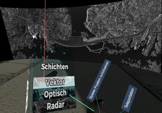
how to increase the immersion level in assistance systems for image interpretation using VR.
The adjacent subquestion is how to design VR systems for image interpretation that fulfill the
quality requirements regarding image fidelity, high resolution and optimal usability in a
professional working context.
    This paper is an extended version of the conference paper (Alexander Streicher, Julien
Hoffmann, 2019). It presents the concept study and prototype realization of the Virtual Reality
Image Exploitation Workspace (VIEW), a VR assistance as well as a training system for image
interpreters (Hoffmann, 2017). The realization targets commercial VR hardware and
implementation in a VR capable game engine. The concept offers answers to some challenges
that are specific for VR for image interpretations, e.g., image fidelity, interaction paradigms or
display of high-resolution imagery.

2. RELATED WORK
Virtual Reality itself has long been an active research topic with multiple industrial appliances
(Nomura and Sawada, 2001). The dome-like display for urban planning by Nomura et al.
influenced our concept (Nomura and Sawada, 2001). Of further inspiration has been the work
of (Streitz et al., 2001); they analyzed how to build interactive office environments by
integrating various display types. In some parts, this has influenced our concept, e.g., the design
and placement of our virtual displays and interaction elements. Other driving work has been
from the hierarchy of needs in VR development by Cronin (Cronin, 2015), with special focus
on the factors interpretability (sense) and usefulness (value).
    For image interpretation VR has been used for visualization geoscience data, e.g, by Lin et
al. with a VR geoscience image interpretation workplace (Lin and Loftin, 1998). We followed
also their Closed World Interaction (CWI) concept that influences the complexity – or rather
simplicity – of intuitive VR interface design with low affordance. Such interaction concepts
should be followed to benefit from VR visualization advantages (Loftin and Nelson, 2000),
although no VR interaction standards exist yet (Malaika, 2015). A popular example of geo-
visualization tool is Google Earth VR that allows the users to experience many places in detail
in 3D (Käser et al., 2017).
    The advantages of using VR for visualizing high resolution image data in an immersive
virtual environment has been presented by (Loftin and Nelson, 2000; Billen et al., 2008). This
is in line with other work which show that geoscience can benefit from VR interaction
possibilities (Furumura and Chen, 2004; Ohno and Kageyama, 2007). A Study by Lackey et al.
(Lackey et al., 2016) show how positive VR experiences can reduce stress and workload. Such
kind of immersive environments can optimally utilize the brain’s cognitive capacity to process
visual information (Hubona and Shirah, 2005).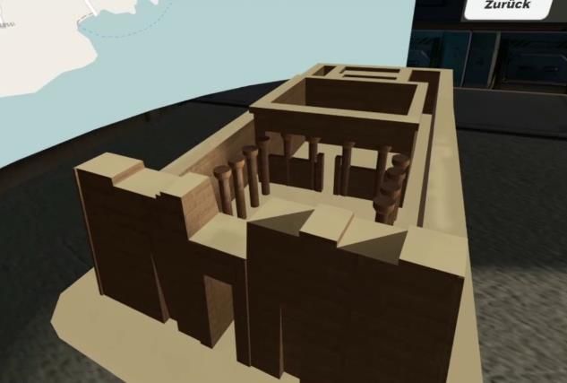
3. VIRTUAL IMAGE EXPLOITATION WORKSPACE (VIEW)
VIEW is a concept for a VR assistance system for image interpreters which incorporates
immersive elements suitable1 for professional image interpretation. In this context an
operational image interpretation assistance system, ViLand (Figure 1), has been used as a base
model for VIEW. Such systems offer tools for image navigation, manipulation and annotation
as well as specific reporting functionalities, e.g., standardized reporting processes and formats.
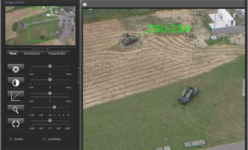
Figure 1. Assistance system ViLand for image interpretation and reporting
3.1 Challenges for a VR Image Exploitation Workbench
We did not simply try to make a VR game. Our goal is to exploit the advantages of VR (like
inherent 3D experience possibilities) for its usage in professional application contexts, in our
case professional image interpretation and image exploitation. Furthermore, we address the
specific field of e-learning and training for image interpreters. Therefore we also study how to
achieve high learning outcomes using such kind of assistance systems for learning and training.
One challenge in this context is to keep users motivated, i.e., a high immersion in the virtual
environment should promote the willingness to keep on using the system and to keep up training
or learning. In the context of this work with VR we asked experts about their reservations, and
three main categories have been identified: effectiveness, technology and usability.
Effectiveness. How to achieve a high level of professionalism? How to exploit serious
gaming principles to improve immersion and learning efficacy? In a professional context
“playing a game” – even if it has been considered a “serious game” – typically does not directly
count as a normal work task. In contrast to this are computer simulations which are used for
training. However, computer simulations typically do not incorporate gamification aspects
which help serious games, i.e., games with a characterizing goal (like as learning), to increase
immersion and motivation and learning outcomes. Being serious and playful at the same time –
1
Suitable in this context means that the professional or serious context is being considered,
i.e., less entertainment in favor of productivity.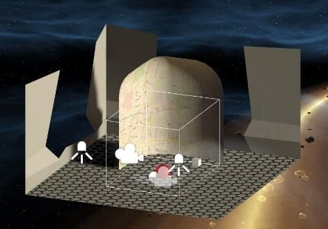
as depicted in the oxymoron “serious game” (Djaouti et al., 2011) – rises concerns in the
professional context and is one of the main challenges.
    Technology. Low initial and running costs are a decisive factor for a corporate widespread
use of a system such as VIEW. Dome-like systems and even professional VR systems have been
around for a long time now, but their high cost prevents them from being used extensively. In
contrast to that is COTS hardware like the Oculus Rift or the HTC Vive (and their derivatives).
However, what are the technological limitations, in particular in respect to image fidelity? What
are the VR hardware limitations (e.g., headset weight, distortions of lenses, display resolutions,
color bit depth, computing performance, etc.), and what are the software limitations (e.g., game
engines, image filtering, software architectures, etc.)? Are commonly used game engines able
to display giga-pixel imagery data without introducing additional unwanted artifacts, e.g., image
compression artifacts? We addressed the hardware and software challenges separately. For
hardware we examined how users perceive known VR artifacts in COTS VR hardware, i.e., we
do not modify the hardware but we try to minimize their effects on the usage experience. An
additional challenge would be, of course, if we would try to replicate image quality in VR as
known by professional displays. Currently, with normal COTS VR hardware this is not possible
without major hardware modification (display and lenses). For software we propose to use a
decentralized map-server based software architecture with tiled images (details in next section).
    Usability. The effectiveness of the user interface is key. The questions asked have been how
to achieve high usability and high affordance? How to find the best-suited VR human-computer-
interaction (HCI) paradigms? The problem is that no commonly established VR HCI standards
exist yet (Hoffmann, 2017) and existing principles from entertainment have to be transferred to
professional contexts in a useable manner. Whereas some VR interaction ideas are helpful for
immersion in an entertainment setting (like drawing a virtual bow), no one wants to do that for
a long period of time (Hoppe, 2016), e.g., strenuous, sweeping arm movements to manipulate
the virtual image display.

3.2 Virtual Image Display (VID)
For image interpretation, the Virtual Image Display (VID) is apparently the most important
aspect. Based on requirements analysis with experts on aerial and satellite image interpretation
the demands for a VR display comprise: high resolution, image fidelity, multi-channel imagery
and image manipulation.
    The VID is a virtual monitor where the imagery data is displayed, navigated or modified; it
is VIEW's primary user interface (UI) component. In the game engine this is technically a
dynamic texture. Various manifestations of the texture's underlying model have been discussed
and evaluated (Figure 2): flat or curved plane, quarter-, half- or full dome, or 360 degree
panorama. The objective is to maximize the visible display for quick and sound recognition.
Although this leads to a half- or full dome or a 360 degree panorama, it is not the typical type
of content in image interpretation. Also it necessitates ample head movements which hinders
quick recognition and has the risk of fatigue (Hoppe, 2016). Dome-like approaches (Figure 2)
inherently impose too much unacceptable vertical and horizontal distortions on the image data.
Image interpreters require a reliable and undistorted display. Although a flat plane does not
impose distortions effects on the texture (no curvature), it proved difficult for the users to view
content in the corners for a big VID. This leads to a compromise: a curved VID (Figure 2). The
curved model requires less head movements and can cover the peripheral vision.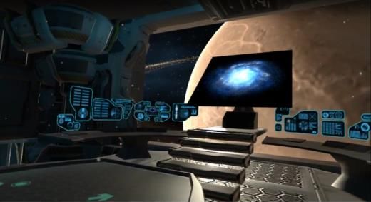
Figure 2. Display concepts. (left) dome-like display with avatar in the center; (right) curved display

High Resolution
The “virtual resolution” should be as high as possible to display as much content as possible.
Professional image interpreters often use multi-monitor workstations for maximum display of
image data as well as instant access to tools. Especially in aerial or satellite image interpretation
with huge images or maps one monitor is used for maps, one for the tools (e.g., reporting tool),
and the remaining monitors for displaying and working with one or multiple images, e.g.,
navigating, annotating, modifying, etc.
    The challenge is to display huge image data that does not fit into the GPU memory. A typical
aerial image easily exceeds 50 megapixels and 1500 MB. Today’s game engines and GPU allow
a maximum size of 8192x8192 pixels for a texture. Therefore, the image has either to be scaled
(loosing details) or split up.
    The solution approach is to use tiled rendering. We propose to use a software architecture
(Figure 3) with a map-server, e.g., GeoServer 2, and a slippy map framework, e.g.,
UnitySlippyMap3 for Unity3D. This enables the integration of various sources, e.g., vector
maps, (geo-referenced) images, markers, etc.

       Figure 3. VIEW software architecture using Unity game engine and GeoServer for image tiling

2
    www.geoserver.org, open source mapserver server for geospatial data sharing.
3
    https://github.com/jderrough/UnitySlippyMap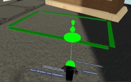
Image Fidelity
The correct and sound image rendering and display is essential; the user acceptance towards the
interpretation system highly correlates with the subjectively recognizable display quality.
Professional image interpretation implements technical measures to ensure image fidelity, e.g.,
special hardware with higher color range (i.e., 10 bit per color channel instead of consumer 8
bit) or calibrated displays. Software measures include lossless compression or accountable
metadata management, e.g., for validated documentation processes. The geospatial server
approach solves this for our VIEW concept. In the rendering engine, image modifications (e.g.,
compression) must be disabled, and textures must have uniform, neutral-colored lighting.
    Critical and not yet solved issues concerns the VR hardware, in particular the head-mounted
display (HMD). Whereas continuous development shows an increase in the HMD display
resolutions, some negative effects can still be seen (Anthes et al., 2016), like the latency, screen-
door effect, lens distortions, ring effects or light rays. We propose to lay the focus on the
usability and the subjective acceptance level for the target group, e.g., by a pre-study and
requirement analysis.
Multi Channel Imagery Display
A further requirement is the possibility to display various types of imagery data, i.e., electro-
optical (EO), infrared, radar and hyperspectral. Ideally, video streams should be supported as
well. Important is the overlay aspect and geo-referencing. It must be possible to display the very
same object or area in different visual channels but with identical alignment. For an area this
means that the location of the overlaid images must be identical. The map-server approach
solves this by providing access to different map or image sources which can be combined with
overlay layers. In VR/VIEW the VID is just the window to the map-server and the layer
switching is propagated to the server by means of standard protocols (e.g., web map service,
WMS).

3.3 Interaction Concepts
Especially in a professional working context the interaction paradigms must be swift and
without risk of fatigue, and, of course, the typical usability requirements must be met. In VR no
commonly accepted interaction standards have been defined yet (Malaika, 2015; Hoppe, 2016).
Analogous to smartphone gestures development the ongoing VR development will show which
emerging interaction paradigms will succeed (Malaika, 2015). Table 1 summarizes some
common interaction paradigms.
    In general, commonly accepted usability principles like Fitt's Law provide helpful design
guidelines. Fitt’s Law states user interface requirements for fast and purposeful movements. A
study by (Hoppe, 2016) shows that the UI must be quick, intuitive and easy to work with. We
adopted the study's strategies in our concept. A special focus is on the workplace suitability, i.e.,
wearisome sweeping gestures risk fatigue, or the UI must be easy to find and use.
    In our concept we focus on the HTC Vive hardware with two controllers. For the interaction
with the VID the principles from gesture and smartphone interaction are followed. Display
translation can be done via pointing a virtual “laser pointer” and using a controller button
dedicated for “left-click” and moving the controller in the designated direction. This is similar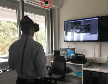
to smartphone interaction for moving the display content with one finger. The operations for
zooming/scaling and rotating are analogous, i.e., moving controllers apart for zooming, and
rotating one controller around a fixed controller for rotation.
The tools must always be ready and easy to use. We propose to adopt the interaction-cube
idea from Google Tilt Brush4. It should provide easy access to the most common operations,
like layer selection, image or scenario reset, contextual assistance.
Table 1. Overview of some common interaction concepts from arbitrarily selected example VR
applications
Concept Manifestation Example
Locomotion
With teleportation Point-to-teleport Vivecraft
Teleportation with sphere The Lab
Without teleportation No teleportation Keep Talking
Float using touchpad Google Earth
Walk using touchpad or controller VR
Walk (room-scale) Subnautica
The Lab
Interaction With Images
Zoom Head movements Keep Talking
Stepwise by area selection World of
Dragging finger on touchpad Comenius
Batman VR
Pan / move Press and drag Google Earth
Head movements VR
VR Cross View
Manipulations
Extended functionality One hand activates functions for Tilt Brush
other hand Subnautica
Separate console
Text input Speech recognition Starship Cmd.
Large virtual keyboard VR
Onward
Object manipulation Controller grip and movement Nvidia
Funhouse
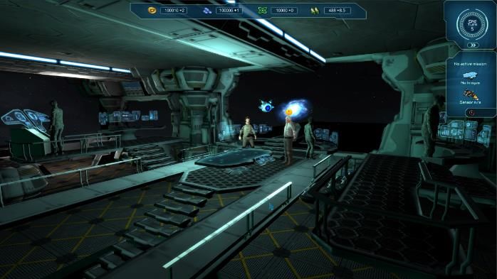
4. APPLICATION
We have verified our concept in a prototype which we implemented using the Unity Game
Engine (Figure 5, Figure 6). For the VR integration with the HTC Vive hardware we used Steam
VR and the feature rich Virtual Reality Toolkit5 (VRTK). To increase the immersion level we
implemented the elements of the VIEW concept. This includes scenery, display and interaction
4
www.tiltbrush.com, 3D painting VR application useable with motion controllers.
5
https://vrtoolkit.readme.io, a collection of scripts for Unity3D for VR development.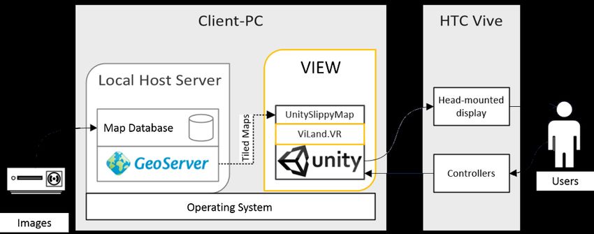
paradigms. Gamification aspects involve the integration of assets from a serious game for image
interpretation (Atorf, Kannegieser and Roller, 2019). We adopted the original game’s science
fiction setting which plays in space in a far future. The virtual image interpretation display is
placed on the game’s spaceship bridge, but whilst the original game itself has a fixed camera
position, in VIEW the player is able to move around and play with various elements of the
virtual bridge. Lighting and arrangement of the assets are congruent to the original game that
has been developed in close cooperation with the target group of image interpreters. To further
increase immersion, we added ambient “sci-fi bridge” background sounds.

Figure 4. Bridge scene of the serious game “Lost Earth 2307” (© Fraunhofer IOSB) (Atorf, Kannegieser
                                           and Roller, 2019)
    The virtual image display (Figure 6, left) is curved to completely match the field of vision
of the players - if they stay directly in front of it. To fulfill fidelity requirements the virtual
display lighting is uniform in neutral white, i.e., no spots, no colored light, no shadows.
Especially for radar images this is of high importance because of the black-white nature of the
image material.
    As explained in the VIEW concept we decided against a 360 degree virtual display because
of the increased movements efforts and risk of fatigue. This also holds true for a virtual dome.
The virtual display is a curved texture with a slippy map image tiling approach. When the user
interacts with the texture, it is modified accordingly, e.g., translation, rotation or scaling. The
use can select the type of image on the interaction cube, i.e., switch between the various layers
of the underlying map-server to display different image channels for the displayed map location.
In the VIEW prototype users can compare three different image channels, i.e., select between a
vector map from OpenStreetMap.org, a high-resolution optical satellite image, and a radar
image (Figure 7). In our example setting each image channel displays the same location, the
Aswan High Dam in South Egypt (Figure 7). One of the challenges for realizing the prototype
was to find usable image material from the same location that met the quality requirements (e.g.,
up-to date or almost identical recording time, high resolution, integrity, etc.).
    For gamification, the image interpretation tasks are aligned to a storyline which deals with
the Aswan High Dam and sabotage actions of fictional rebels. Users must solve image
interpretation tasks, e.g., locate rebel camps or analyze road networks, to help the local
authorities capture the rebels. In the training scenario additional challenges have been
introduced to adjust the difficulty and cover all learning objectives, e.g., clouded high-resolution
optical images which prompt the users to switch to radar imagery which is not affected by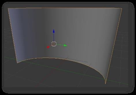
atmospheric conditions. Further gamification aspects include competitive components like
achievements and high-score boards.

         Figure 5. (left) VIEW scenery, sci-fi bridge setting; (right) movement by teleportation

Figure 6. (left) VIEW prototype with bridge scene, teleportation interaction, and curved display for maps
                             and images. (right) 3D model interaction mode

Figure 7. Identical location (Aswan High Dam) but different image channels: (left) vector map, (center)
                               clouded optical image, (right) radar image

5. DISCUSSION
A preliminary evaluation of the VIEW prototype with n=16 users (average age 35, 14 male)
showed an overall positive acceptance rate and good presence level. The game elements have
been evaluated positively and as beneficial for immersion. Also positively evaluated were the
3D modes (Figure 6, right), the different image layers and that the user always is in control. Of
negative impact was the grip interaction; the location of the button on the HTC Vive controller
was unclear to the participants. Table 2 shows positive and negative statements (translated from
German). The results indicate that image interpretations can benefit from VR by increased
immersion (e.g., by gamification or spatial presence) and by experiencing spatial content or 3D
objects in a more natural way.
Table 2. Positive and negative responses to VIEW
Positive Negative
I felt comfortable on the bridge. I'd very much My hands are not to be seen, that would be cool - I do
wanted to continue walking there all the time. not know if that's possible.
The game elements were fun and motivated to The sound does create a higher immersion, but I'd like
carry on with the task. to have my rest at work.
Interaction with map was super! Scaling as intuitive Grip is difficult because the button on the controller is
as expected. It was super that the map got caught placed oddly.
exactly on the [pointing] ray.
A systematic evaluation is going to study the VIEW concept along the dimensions user
acceptance, immersion, image quality recognition, and image interpretation effectivity and
efficiency (including usability). The hypothesis is that VIEW offers effective and immersive
support for image interpretation tasks and helps in training image interpreters. The
questionnaires of interest for us are the Igroup Presence Questionnaire (IPQ), the System
Usability Scale (SUS) score (Brooke, 1996), and RawTLX to measure workload. A Web-
browser 2D replica is going to serve as a reference model. The replica will mimic most of the
features of the VR prototype but obviously address presence and immersion at a different level.
Users can familiarize themselves with VR interaction and settings in a tutorial level (Figure 8),
which includes most of the later on tested elements of the VIEW prototype. Experiments on the
perceived conspicuousness of VR artefacts (like screen door effect, ring effect, lightray effect)
showed that the negative effects by them on perceived image quality and immersion are lower
than expected. The influence of artefacts can be reduced by a correct VR headset setup, e.g. by
individual adjustment of the straps and by an individual adjustment of the interpupillary distance
(IPD) setting of the VR headset. We use an online IPD tool to determine the correct value for
the IPD (Figure 8).
Figure 8. Study setup. (left) VR tutorial level; (center) interpupillary distance measurement (IPD tool);
(right) room-scale setup for the study6. CONCLUSION
This paper presents the concept study for a VR assistance system for image interpretation
(Alexander Streicher, Julien Hoffmann, 2019), the Virtual Reality Image Exploitation
Workspace (VIEW). The application field is aerial image interpretation, i.e., detection,
recognition, identification and analysis of structures and objects, according to a given task based
on optical, infrared or radar imagery. The concept study explored various approaches for virtual
displays as well as interaction paradigms matching the demands for professional image
interpretations. Our concept proposes a virtual environment enriched with game elements to
increase the immersion level. We propose a software architecture for tiled rendering to display
high-resolution imagery data. Gamification elements like real assets from a congruent serious
game, an instruction story, or the possibility to explore the environment promote playability and
immersion. The architecture includes a slippy map module and a server for geospatial data, e.g.,
the open source map-server software. This approach allows including interoperable image data,
labels, annotations, etc. from various sources.
ACKNOWLEDGEMENTS
The underlying project to this article is funded by the Federal Office of Bundeswehr Equipment,
Information Technology and In-Service Support under promotional references. The authors are
responsible for the content of this article.
REFERENCES
Anthes, C., Garcia-Hernández, R.J., Wiedemann, M., Kranzlmüller, D., 2016. State of the art of virtual
reality technology. Aerospace Conference. pp. 1–19.
Atorf, D., Kannegieser, E., Roller, W., 2019. Balancing Realism and Engagement for a Serious Game in
the Domain of Remote Sensing. In: Söbke H. Gentile M., A.M. (Ed.), Games and Learning Alliance.
Springer International Publishing, Cham, pp. 146–156.
Billen, M.I., Kreylos, O., Hamann, B., Jadamec, M.A., Kellogg, L.H., Staadt, O., Sumner, D.Y., 2008. A
geoscience perspective on immersive 3D gridded data visualization. Computers and Geoscience.
1056–1072.
Brooke, J., 1996. SUS - A quick and dirty usability scale. Usability Evaluation in Industry. 189, 4–7.
Connolly, T.M., Boyle, E.A., MacArthur, E., Hainey, T., Boyle, J.M., 2012. A systematic literature review
of empirical evidence on computer games and serious games. Computers & Education.
Cronin, B., 2015. The hierarchy of needs in virtual reality development. Medium.com, URL
https://medium.com/@beaucronin/the-hierarchy-of-needs-in-virtual-reality-development-
4333a4833acc.
Djaouti, D., Alvarez, J., Jessel, J., et al., 2011. Origins of Serious Games. Serious Games and Edutainment
Applications. Springer, London.
Dörner, R., Göbel, S., Effelsberg, W., Wiemeyer, J., 2016. Serious Games - Foundations, Concepts and
Practice. Springer International Publishing, Cham.Freina, L., Ott, M., 2015. A literature review on immersive virtual reality in education: State of the art and
perspectives. Proceedings of eLearning and Software for Education (eLSE)(Bucharest, Romania, April
23--24, 2015).
Furumura, T., Chen, L., 2004. Large scale parallel simulation and visualization of 3D seismic wavefield
using the earth simulator. CMES - Computer Modeling In Engineering And Sciences 6, 153–168.
Ganbatte DevBlog, 2018. Analysing the VR market based on 2017 Steam data. ganbattegame.com. URL
https://ganbattegame.com/blog/2018/01/14/analysing-the-vr-market-based-on-2017-steam-data/.
Hoppe, A.H., 2016. Interaktionskonzepte für WIMP-Applikationen in Virtual Reality. KIT.
Hoffmann, J., 2017. Virtual Reality für Assistenzsysteme in der Bildauswertung. Master Thesis, KIT,
Karlsruhe, Germany.
Hubona, G.S., Shirah, G.W., 2005. Spatial Cues in 3D Visualization. In: Ambient Intelligence for Scientific
Discovery. Springer Berlin Heidelberg, pp. 104–128.
Käser, D. P., Parker, E., Glazier, A., et al., 2017. The Making of Google Earth VR. ACM SIGGRAPH 2017
Talks, Los Angeles, California. ACM Press.
Lackey, S.J., Salcedo, J.N., Szalma, J.L., Hancock, P.A., 2016. The stress and workload of virtual reality
training: the effects of presence, immersion and flow. Ergonomics 0139, 1–13.
Lin, C.-R., Loftin, R.B., 1998. Application of Virtual Reality in the Interpretation of Geoscience Data. In:
VRST ’98 Proceedings of the ACM Symposium on Virtual Reality Software and Technology. ACM
Press, New York, New York, USA, pp. 187–194.
Loftin, R.B., Nelson, H.R., 2000. Interaction with geoscience data in an immersive environment. In:
Proceedings IEEE Virtual Reality 2000 (Cat. No.00CB37048). IEEE Comput. Soc, pp. 55–62.
Malaika, Y., 2015. GDC Vault - Interaction Design in VR: The Rules Have Changed (Again). GDC Europe
2015.
Mazuryk, T., Gervautz, M., 1996. Virtual reality-history, applications, technology and future. Virtual
Reality.
Nomura, J., Sawada, K., 2001. Virtual reality technology and its industrial applications. Annual Reviews
in Control 25, pp 99–109.
Ohno, N., Kageyama, A., 2007. Scientific visualization of geophysical simulation data by the CAVE VR
system with volume rendering. Physics of the Earth and Planetary Interiors 163, 305–311.
Prensky, M., 2001. True Believers: Digital Game-Based Learning in The Military. Digital Game-based
Learning. 1–18.
Riva, G., Davide, F., IJsselsteijn, W.A., 2003. Being there: Concepts, effects and measurements of user
presence in synthetic environments. Ios Press.
Roller, W., Berger, A., Szentes, D., 2013. Technology based training for radar image interpreters. 6th
International Conference on Recent Advances in Space Technologies (RAST). IEEE, pp. 1173–1177.
Streitz, N.A., Tandler, P., Müller-Tomfelde, C., Konomi, S., 2001. Roomware - Towards the Next
Generation of Human-Computer Interaction Based on an Integrated Design of Real and Virtual
Worlds. Human-Computer Interaction in the New Millennium. Pp. 553–578.
Streicher, A., Hoffmann, J., Roller, W., 2019, VIEW: A Concept for an Immersive Virtual Reality Image
Interpretation Workbench. International Conference on Theory and Practice in Modern Computing,
MCCSIS 2019. Porto, Portugal. IADIS Press.You can also read