WGV - WESTGATE VISION - Louth County Council
←
→
Page content transcription
If your browser does not render page correctly, please read the page content below
WGV

                                                                  JUNE 2018
                   A Townscape Recovery Guide
WESTGATE VISION   For Property Owners, Investors and Developers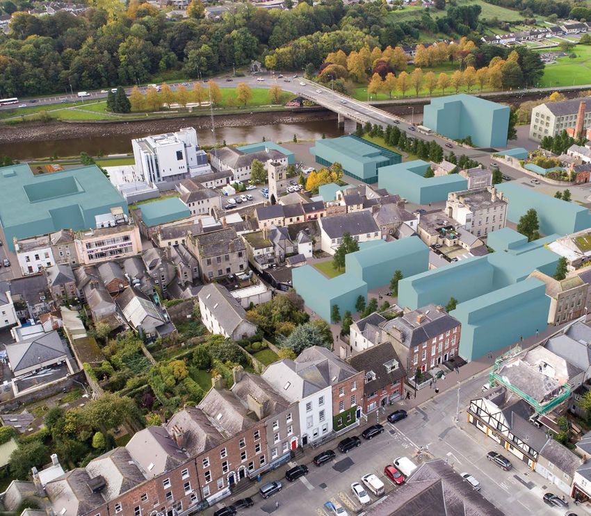
A Townscape Recovery Guide
For Property Owners, Investors and Developers
A Townscape Recovery Guide       3
For Property Owners, Investors and Developers
Contents
             Westgate Vision Executive Summary                                            MAPS
             							                                                                      Map 1.1      Drogheda’s Historical Location
             PART 1                  THE CHALLENGE                                        Map 1.2      Derelict sites and potential derelict sites in WGV Area
             The Drogheda Story                                                           Map 2.1      WGV Study Areas
                                                                                          Map 3.1      Location of the 5 Design Concepts
             PART 2                  THE RESPONSE                                         Map 3.2      George’s Square, Drogheda
             The Vision                                                                   Map 3.3      Re-imagining of pocket spaces in Narrow West Street
                                                                                          Map 3.4      Proposed mixed use/residential courtyards at O’Reilly’s Yard
             PART 3		                THE RECOVERY                                         Map 3.5      Landmark Locations and Features Identified in WGV Area
             The purpose of the Westgate Vision Townscape Recovery Guide                  Map 3.6      Existing Ground Floor Uses
             Location of the 5 Design Concepts                                            Map 3.7      Existing First Floor Uses
             Design Concept 1 | Arrival Space at George’s Square Gateway to Drogheda &    Map 3.8      Existing Second Floor Uses
             		                        Boyne Valley                                       Map 3.9      Topography of Westgate
             Design Concept 2 | Cultural, Entertainment & Recreation Cluster              Map 3.10     Connectivity and Mobility in wider Drogheda Town Centre Area
             Design Concept 3 | New Homes, New Activation , New Population                Map 3.11     Urban Analysis Occupancy Map
             Design Concept 4 | Town Scale Public Space
             Design Concept 5 | Tourist Residential Neighbourhood & Riverside Promenade
             Urban Analysis Westgate Vision Area
             Barlow Area Response                                                         FIGURES
             Old Abbey Area Response                                                      Figure 1.1   Gabriele Ricciardelli 18th century view of Drogheda
             Donaghy’s Mill Area Response                                                 Figure 1.2   Population within 60km of Irish Cities and Towns
             Townscape Recovery Vision                                                    Figure 1.3   Dublin-Belfast Economic Corridor
                                                                                          Figure 3.1   Gateway to Drogheda Town Centre
             PART 4                  DELIVERING THE VISION                                Figure 3.2   Siena Town Hall
             Townscape Recovery Stage 1 : Short Term Delivery of the Vision               Figure 3.3   Gateway to Drogheda Town Centre
             Townscape Recovery Stage 2 : Medium Term Delivery of the Vision              Figure 3.4   Desire Line – Line of Vision to Donaghy’s Mill
             Townscape Recovery Stage 3 : Long Term Delivery of the Vision                Figure 3.5   Existing vacant section of O’Reilly’s Yard
                                                                                          Figure 3.6   Proposed mixed use/residential courtyards of O’Reilly’s Yard
                                                                                          Figure 3.7   Potential Town Scale Public Space
                                                                                          Figure 3.8   New Town Scale Public Space
                                                                                          Figure 3.9   Potential Re-imagining of the Old Abbey Shopping Centre
                                                                                          Figure 3.10 Extract of Gabriele Ricciardelli’s 18th century view of Drogheda from Millmount
                                                                                          Figure 3.11 Possible Design Concepts in Donaghy’s Mill Study Area
                                                                                          Figure 3.12 Existing Section AA
                                                                                          Figure 3.13 Existing Section BB
                                                                                          Figure 3.14 Section showing potential area for improvement
                                                                                          Figure 3.15 Possible Conservation/ Intervention

4   A Townscape Recovery Guide
    For Property Owners, Investors and Developers
A Townscape Recovery Guide       5
                                                                                                                                For Property Owners, Investors and Developers

Contents
Figure 3.16 Proposed Ground Floor Uses                                     PHOTOS
Figure 3.17 Proposed First Floor Uses                                      Photo 1.1   Westgate Vision Area
Figure 3.18 Proposed Section AA                                            Photo 1.2   Narrow West Street
Figure 3.19 Proposed Section BB                                            Photo 3.1   Kilkenny Castle, Kilkenny
Figure 3.20 Indicative footprint of infill housing in Barlow Study Area    Photo 3.2   Bordeaux, France
Figure 3.21 Possible opportunity to provide quality housing while          Photo 3.3   Bridge of Peace, Drogheda
             achieving permeability in Barlow Study Area                   Photo 3.4   Entertainment
Figure 3.22 Possible Connectivity Improvements                             Photo 3.5   Shop Street, Galway City
Figure 3.23 Possible Mobility Improvements                                 Photo 3.6   Old Abbey Lane
Figure 3.24 Possible Landscape Improvements                                Photo 3.7   Barlow House, West Street
Figure 3.25 Possible Public Realm Enhancements, Barlow Study Area          Photo 3.8   New Town Centre Housing, Waterford City
Figure 3.26 Re-imagining of the Public Realm                               Photo 3.9   Town Centre Housing Development
Figure 3.27 Possible Conservation/ Intervention                            Photo 3.10 Barlow and Old Abbey Areas
Figure 3.28 Proposed Ground Floor Uses                                     Photo 3.11 Old Abbey Area
Figure 3.29 Proposed First Floor Uses                                      Photo 3.12 Oasis Project, Omagh, Co. Tyrone
Figure 3.30 Gabriele Ricciardelli 18th century view of Drogheda            Photos 3.13 – 3.17 Examples of Re-Use, Adaption and New-build in Dublin
Figure 3.31 Possible redevelopment within Old Abbey Study Area             Photo 3.18 Interior of Barlow House, West Street
Figure 3.32 Possible Connectivity Improvements                             Photo 3.19 Exterior of Barlow House, West Street
Figure 3.33 Possible Mobility Improvements                                 Photo 3.20 Dance Studios, Old Abbey Lane
Figure 3.34 Possible Landscape Improvements                                Photo 3.21 Dance Studios, Old Abbey Lane
Figure 3.35 Design Concept Three, Old Abbey Study Area                     Photo 3.22 Old Abbey Area, Westgate
Figure 3.36 Possible Public Realm Enhancements, Old Abbey Study Area       Photo 3.23 Old Abbey Lane, Westgate
Figure 3.37 Proposed Conservation/ Intervention                            Photo 3.24 Good quality housing possible while achieving permeability
Figure 3.38 Proposed Ground Floor Uses                                     Photo 4.1   Graffiti at Bridge of Peace, Drogheda
Figure 3.39 Proposed First Floor Uses                                      Photo 4.2    Peter Street
Figure 3.40 Existing Section Donaghy’s Mill Study Area                     Photo 4.3    Narrow West Street
Figure 3.41 Proposed Section Donaghy’s Mill Study Area                     Photo 4.4    West Street
Figure 3.42 Proposed redevelopment within Donaghy’s Mill Study Area        Photo 4.5   Patrickswell Lane
Figure 3.43 Possible Connectivity Improvements                             Photo 4.6   Narrow West Street
Figure 3.44 Possible Mobility Improvements                                 Photo 4.7   Narrow West Street
Figure 3.45 Possible Landscape Improvements                                Photo 4.8   Drogheda Arts Festival
Figure 3.46 Possible Interventions surrounding the Bridge of Peace         Photo 4.9   St Laurence’s Gate
Figure 3.47 Possible Public Realm Enhancements Donaghy’s Mill Study Area   Photo 4.10 Re-Use and Adaption:
Figure 3.48 Westgate Public Realm Possibilities                                        National Gallery of Ireland, Merrion Square West, Dublin 2
Figure 3.49 Westgate Area Arrival
Figure 3.50 Westgate Development Opportunity Diagram
Figure 3.51 Old Infrastructure, New Street & Green Connections
Figure 3.52 The Westgate Vision Diagram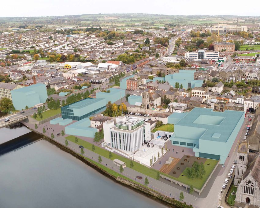
Westgate Vision
                                                                                                       The Westgate Vision comprises the following integrated documents as
                                                                                                       outlined below:

             Executive Summary                                                                         The Challenge details the historical, spatial and urban context while identifying
                                                                                                       the interdependent hinterland and local urban planning challenges. The hinterland
             Drogheda, located at the gateway to the Boyne Valley is a historic international port     challenge in principal is suburban growth and town centre decline. The local
             town on Ireland’s east coast. The story of Drogheda is evident in its archaeology,        challenge is the need for urban regeneration in Westgate where there is a high level
             architecture and rich urban heritage. The modern town of Drogheda comprises a             of vacancy and dereliction.
             historic town core within a broad suburban hinterland.
                                                                                                       The Response comprises a clear identification of the spatial extent of Westgate and
             The town centre vision is a vibrant retail, entertainment and cultural destination,       the need for an urban design vision to recover the streetscape. A vision statement
             quality home and preferred place of employment at the heart of its suburban               for Westgate and the broader town centre is captured in the opening statement.
             hinterland. However, peripheral parts of the town centre in common with many
                                                                                                       The Recovery comprises a guide to townscape recovery, which analyses the
             other Irish cities and towns have lost their purpose and are underperforming. This
                                                                                                       existing urban fabric and identifies opportunities where reuse, redevelopment and
             is clearly evident in terms of dereliction, vacancy and lack of vitality in Narrow West
                                                                                                       public realm improvement are possible. The guide to townscape recovery identifies
             Street and the surrounding Westgate area.
                                                                                                       5 design concepts to support the regeneration of Westgate aligned with the vision
             The Urban Design Framework Plan for the Heritage Quarter Drogheda 2013,                   statement. A number of opportunity sites are identified where development
             commissioned by Louth Local Authorities, identifies parts of the town as requiring        could be applied for under the provisions of the relevant Development Plan. The
             comprehensive urban regeneration including the underperforming area at the                urban design vision to recover the townscape comprises an integrated blueprint
             western extremity of the circuit of the medieval town walls at Westgate. In response      of possible development and public realm interventions, which would recover the
             Louth County Council has prepared an urban regeneration Vision for Westgate. The          streetscape, transform Westgate and establish a positive regeneration dynamic in
             Westgate Vision is a guide for townscape recovery within a 10 year plus delivery          the broader town centre.
             timeframe. The guide to townscape recovery is targeted at property owners,
                                                                                                       Delivering the Vision comprises a detailed implementation breakdown in 3
             investors, developers and their agents.
                                                                                                       stages over a 10 year plus timeframe. The short term delivery (3 months-3 years),
             The Westgate Vision (WGV) Area comprises: The Barlow House Area, between                  includes a list of ‘Quick wins’ that are cost effective but can have a significant positive
             George’s Square and Scholes Lane including Narrow West Street and extending               physical impact. The medium-term (3 – 5 years) and long-term (5 – 10 years plus)
             north to Fair Street; the Old Abbey Lane Area, between Narrow West Street and the         deliverables are identified as the transformative townscape interventions requiring
             River Boyne extending east to Dominic Street; and west to the Bridge of Peace and         a greater lead in time. It is proposed to prepare a monitoring report at the end of
             the Donaghy’s Mills Area west of the Bridge of Peace and south of Trinity Street.         each delivery stage against 6 identified performance indicators. The final section of
                                                                                                       the delivery identifies best practice in the preparation of development proposals for
                                                                                                       assessment by the planning authority.

6   A Townscape Recovery Guide
    For Property Owners, Investors and Developers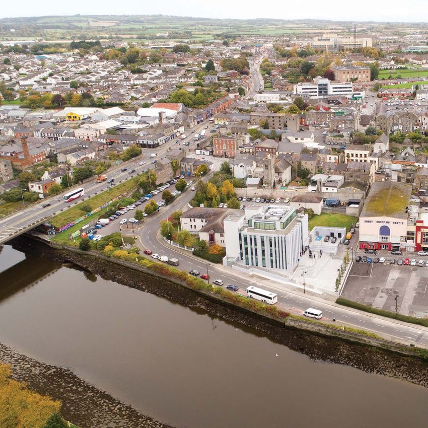
7

PART 1
THE CHALLENGE
The Drogheda Story
                                                                                        The Irish Parliament, before the establishment of Dublin as the administrative
Drogheda is at a crossroads where two major routes of ancient Ireland meet,
                                                                                        capital, met in four principal locations on the island: Drogheda, Dublin, Kilkenny
connecting the north and south of the island with the west. The port of Drogheda
                                                                                        and Waterford. The enactment in Drogheda of Poynings Law in 1494, which made
connected the Boyne Valley and this part of the island internationally. Drogheda in
                                                                                        the Irish parliament subservient to the English parliament in Westminster, is an
modern Ireland retains its gateway status providing ease of access to its hinterland,
                                                                                        example of Drogheda’s status as a national political and administrative centre. The
including the Battle of the Boyne heritage site at Oldbridge and the World Heritage
                                                                                        story of Drogheda may have been more gilded if the Irish capital had been settled
site at Brú Na Bóinne and national access via the motorway and rail network.
                                                                                        at the mouth of the River Boyne, cementing the ancient status of the Boyne Valley
The Drogheda story from its foundation in the 12th century comprises significant        as the political centre on the island, rather than on the banks of the River Liffey in
events in Irish history most notably the sacking of Drogheda by Cromwell’s forces in    Dublin.
1649 and the Battle of the Boyne in 1690. The status of the port town in medieval
Ireland and its primacy in the life of the Pale, is well documented. Drogheda during
this period enjoyed premier status in the Irish urban hierarchy and the broader
urban network in these islands as a centre of population and trade.

                                                                                        FIG 1.1 Gabriele Ricciardelli 18th century view of Drogheda

    MAP 1.1 Drogheda’s historical location
    where two major roadways of ancient
    Ireland meet.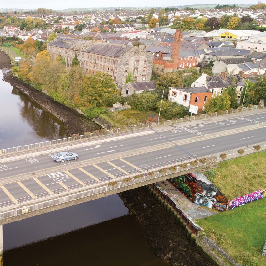
Drogheda’s story and significance can be appreciated in the extent, quality and variety of the physical fabric remaining from the medieval and post-medieval town
             constructed from the 17th to 19th century. The medieval town is evidenced in the remains of churches and religious houses and the network of lanes and streets. The
             barbican of St. Laurence’s Gate is symbolic of the elevated status, wealth and importance of Drogheda in late medieval Ireland. The post-medieval town can be fully
             appreciated in the wealth of 18th buildings, in particular the merchant town houses such as Barlow House, as Drogheda entered the modern era.

             The Contemporary Challenge
             Modern Drogheda is a regional growth centre in the expanding Dublin metropolitan area with Census
             2016 showing a higher than average population increase in Drogheda and its hinterland. Drogheda has
             expanded most rapidly to the south of the Boyne River with less extensive suburbanisation to the north.
             This expansion comprises a fragmented pattern of residential estates interspersed with car-dependent
             commercial and industrial areas including significant out-of-town retailing. The location of Drogheda on
             the Dublin-Belfast economic corridor, with easily accessible road and rail links and proximity to Dublin
             airport will ensure sustained growth pressures.

                                                                                                                                      FIG 1.2   Population within 60 km of Irish cities and towns

                                                                         Drogheda due to its topography and historical development has inherited a unique urban environment. The
                                                                         north side of the town is structured by the urban spine of St Laurence’s Street-West Street with a network of
                                                                         narrow streets and lanes radiating southwards towards the river and northwards towards the higher ground of
                                                                         Fair Street. It is this street / lane pattern of urban space which the visitor experiences as they move through the
                                                                         town from east to west (St. Laurence’s Gate to Narrow West Street) and from south to north (the Quays along
                                                                         Fair Street). Drogheda offers a positive and vibrant urban experience, which comprises quality streets and public
                                                                         spaces with active ground floor uses. However, the experience is not consistent because of under-investment,
                                                                         vacancy and dereliction in peripheral parts of the town centre (see photo 1.2).

                                                FIG 1.3 Dublin-Belfast
                                                Economic Corridor

8   A Townscape Recovery Guide
    For Property Owners, Investors and Developers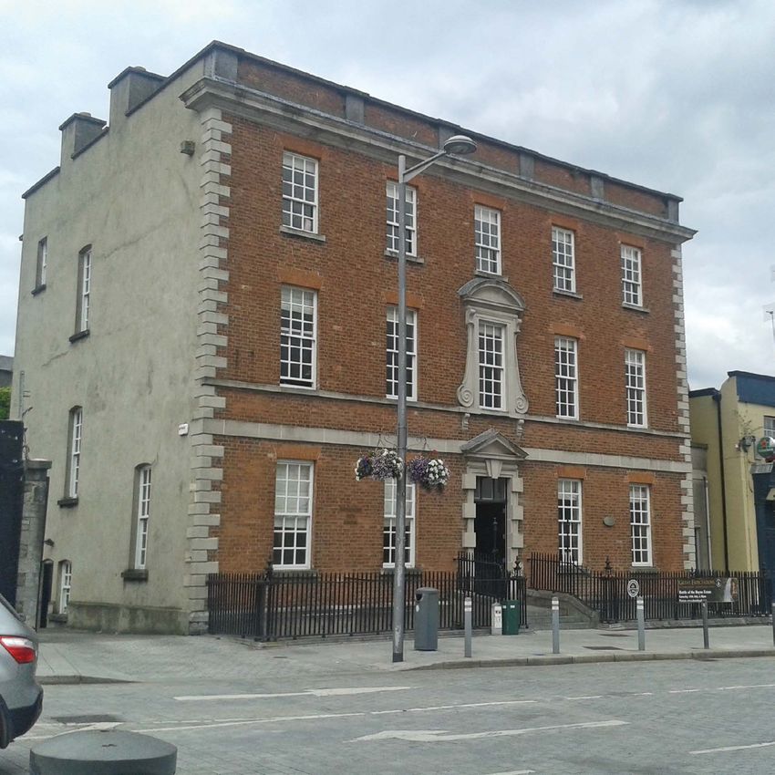
A Townscape Recovery Guide 9
For Property Owners, Investors and Developers
Understanding the Challenge
Development economics dictates that greenfield / suburban development is
more cost effective and less complicated than that in towns and cities. In tandem,
changes in shopping patterns, lifestyle choices, and car ownership have undermined
the functionality of urban centres. Investment is attracted to the edge of towns
where greenfield development sites are easily accessible by car, or in defined
retail / commercial core areas within town centres. Thus the traditional town
centre has suffered under these pressures as towns have retreated to their core
and peripheral areas have been hollowed out and lost their vitality and purpose.
The suburbanisation of Drogheda in common with other Irish towns and cities is
reflected in areas of underuse, dereliction and vacancy.
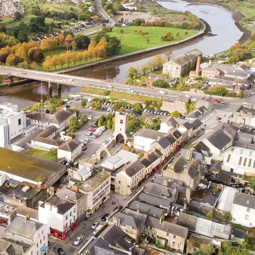
Narrow West Street and its environs is an area in Drogheda reflective of these
challenges. Located to the western extremity of West Street and adjacent to the
MAP 1.2 Derelict sites (blue) and
nodal point of Westgate, one of the former medieval gates of the historic town
potential derelict sites (green) in
walls, the Narrow West Street area requires focused intervention (see Map 1.2). The
WGV Area
specific challenge of dereliction and vacancy in the Narrow West Street Area is
acknowledged and needs to be addressed in combination with the wider challenges.
These challenges include:
PHOTO 1.1 Westgate Vision Area
How Drogheda meets the needs of future population growth and economic
activity within the town core and as a focal point for its expanding modern
hinterland;
Ensuring new development respects and enhances the architecture and urban
grain of the historic town.
PHOTO 1.2 Narrow West Street
The response to the challenge is partly contained within the guidance of the Urban
Design Framework Plan (2013), commissioned by Louth Local Authorities, as a
THE POPULATION
DROGHEDA OF THE
BELFAST
INCREASED
IT’S POPULATION, UNLIKE OTHER
URBAN
AREA OF
DUBLIN LARGE IRISH TOWNS DROGHEDA TOWN
HAS INCREASED
BY 6.2% SINCE 2011
TO 40,956
comprehensive heritage plan for Drogheda town centre. However, it is considered              Development Plan 2011-2017 (as extended) until this Plan is replaced by a future
              that a more focused, area-based approach is required in order to address the                 urban plan for the town. Furthermore, it is recommended that proposals for future
              specific challenge of Narrow West Street and environs. The area will be referenced           development comply with additional Environmental Appraisal recommendations.
              as the Westgate Vision Area (WGV Area).

                                                                                                           Status of the Westgate Vision
              Environmental Considerations                                                                 The WGV is a non-statutory, advisory document that illustrates to developers,
              The WGV has been prepared with environmental considerations being one of the                 property owners and investors how to comply with the provisions and zoning
              key informants and influences.                                                               contained within the existing DBCDP 2011-2017 (as extended) and the LCDP 2015
                                                                                                           - 2021. It is intended to guide the community and developers in their consideration
              The Environmental Appraisal that has been undertaken identifies that the
                                                                                                           of future development proposals.
                                                     WGV has the potential to contribute towards
                                                     environmental protection and management               The WGV does not define rules and procedures that must be complied with, rather
                                                     across a wide range of issues including               it provides guidance on how the provisions of the Development Plans can be
                                                     sustainable mobility, emissions, cultural heritage,   achieved.
                                                     ecology, surface water status and flood risk
                                                                                                           Where the WGV includes details that are not covered by the DBCDP 2011-2017 (as
                                                     management (see findings of the Environmental
                                                                                                           extended), these shall be assessed under the provisions of the LCDP 2015-2021 (or
                                                     Appraisal).
                                                                                                           any future replacement).
                                                     The Appropriate Assessment (AA) Screening
                                                     that has been undertaken (an AA Screening
                                                     Statement accompanies the WGV) demonstrates
                                                     that the WGV will not affect the integrity of
                                                     European Sites of ecological value including the
                                                     River Boyne Special Area of Conservation (SAC)
                                                     and the River Boyne Special Protection Area
                                                     (SPA).

                                                     Future developments at Westgate are required
                                                     to comply with the existing provisions of the
                                                     Drogheda Borough Council Development Plan
                                                     (DBCDP) 2011-2017 (as extended) and the Louth
                                                     County Development Plan (LCDP) 2015-2021
                                                     (and their successors) including those relating
                                                     to environmental protection and management.
                                                                                                           This is Map 5.11 of the Urban Design Framework Plan for the Heritage Quarter, Drogheda
                                                     It is recommended that proposals for future
                                                                                                           (2013) showing Intervention - Recovery - Opportunity.
                                                     development comply with the environmental
                                                     provisions of the Drogheda Borough Council

10   A Townscape Recovery Guide
     For Property Owners, Investors and Developers
11
PART 2
THE RESPONSE
The Vision Westgate is the identifiable principal
The following six Strategic Guiding Objectives are identified in response to the
entry point to the historic town of
challenge in Drogheda: Drogheda and the premier gateway
for visitors to the Boyne Valley.
Exploiting the distinctive character and
1 2 3 heritage of Westgate, the Drogheda
Westgate and the Westgate as the Recovery of the Heritage Quarter Framework Plan
broader town centre gateway to Drogheda’s townscape in Westgate 2013 is implemented with creativity,
as the vibrant heart of historic Town Centre to act as a catylst for
practicality and conviction. Thus is
the wider hinterland and the Boyne Valley positive regeneration
heritage sites in the broader town achieved the economic, environmental
centre and social benefits of quality-driven
urban regeneration within the
Westgate area and within the broader
4 5 6 town centre.
Delivery of quality Directional Implementation of Best
WESTGATE
homes and environment for private Practice Conservation
employment and public sector
opportunities investment decisions
VISION
& the co-ordination
of built environment
regulation and
guidance
These are aligned with the criteria concerning ‘Compact Growth’ as outlined in National
Strategic Outcome 1 of Project Ireland 2040, which aims to;
Enable infill/brownfield development that wouldn’t otherwise occur.
Improve liveability.
Encourage economic development by creating conditions to attract investment.
Build on existing assets to create critical mass.
Improve accessibility & transition to sustainable modes of transport.
Provide affordable houses, improved family services, etc.Westgate Urban Design Response Docklands are cited as successful examples of regeneration guided by a shared,
and pre-determinded urban design vision.
To this end bespoke urban design guidance has been prepared in a Townscape
Department of Housing, Planning and Local Government (DHPLG) guidelines and
Recovery Guide for Westgate.
accompanying best practice such as the Urban Design Manual (2009) emphasise
the importance of urban design in achieving quality outcomes. In the context of The Townscape Recovery Guide will act as supporting guidance in the
the specific challenge of Westgate, it is considered that area based urban design implementation of the Urban Design Framework Plan for the Heritage Quarter
guidance is required in addition to the relevant statutory and non-statutory plans (2013). It is envisaged that both of these documents together with the Statutory
and policy documents. Plan(s) will provide full complementary guidance in achieving the regeneration of
the WGV Area aligned with the Vision Statement.
Area based urban renewal has a proven record in achieving sustainable, systematic
and value added urban regeneration. The examples of Temple Bar and the Dublin
12 A Townscape Recovery Guide
For Property Owners, Investors and DevelopersA Townscape Recovery Guide 13
For Property Owners, Investors and Developers
Westgate Vision Area Definition
and Description
The WGV Area comprises lands strategically located at the western extremity of
the town centre around the medieval West Gate in the town wall. It is a gateway
location to the town centre and the wider Boyne Valley. The WGV Area comprises 3
interdependent Study Areas. They are characterised by a high level of underutilised
buildings and vacant land. The WGV Area is bounded to the south by the northern
bank of the River Boyne which:Area 1
BARLOW
Represents an important natural feature and potential promenade.
DONAGHY’S
Is bisected at this location by the Bridge of Peace (R132). MILL
Has an existing under-pass at the Bridge of Peace, albeit is closed at the
Donaghy’s Mill end.
OLD ABBEY
The 3 Study Areas are
Barlow
Old Abbey
Donaghy’s Mill
Barlow
Old Abbey
Donaghy’s Mill
MAP 2.1 WGV Study Areas14 A Townscape Recovery Guide
For Property Owners, Investors and Developers15 PART 3 THE RECOVERY The Townscape Recovery Guide Identifying the possibilites for urban regeneration to realise the vision Opportunity Sites identified Reuse and Adaption of existing buildings An Integrated Urban Design Strategy to recover the streetscape Westgate Vision supporting regeneration in the broader town centre
16   A Townscape Recovery Guide
     For Property Owners, Investors and Developers
A Townscape Recovery Guide 17
For Property Owners, Investors and Developers
The Purpose of the Westgate Vision Townscape Recovery Guide
Project Ireland 2040 (National Planning Framework & National Development Plan) acknowledges that a more strategic and centrally managed approach to enhancing the
development potential of publically owned lands is needed. The establishment of the National Regeneration & Development Agency (NRDA) will require co-ordinated
planning at strategic and urban levels and in the operation of available funding. Within the WGV Area there are significant vacant and brownfield lands in public ownership
which lend themselves to effective strategic land management and enhanced development potential.
The NPF requires co-ordinated strategies for Dundalk consideration of future development proposals. The Medium Term Delivery of Vision
and Drogheda at both regional and town levels to following are the principal concepts that could support 3-5 years 2021-2023
ensure they have capacity to grow sustainably. The the Westgate regeneration aligned with the Vision:
Long Term Delivery of Vision
strategic importance of Drogheda is recognised in the
5-10 years plus 2023-2028 plus
wider Greater Dublin Area and in the Dublin-Belfast George’s Square - Arrival space – Gateway to
economic and transport corridor. The Townscape Drogheda & the Boyne Valley The medium and long-term deliverables are identified
Recovery Guide analyses the existing urban fabric as the transformative interventions requiring a lead in
Old Abbey Lane/ Narrow West Street - Cultural
and identifies a number of exisiting and proposed entertainment/ recreation cluster time greater than 3 years. The combination of all three
opportunities where feasibility for redevelopment and timeframes comprises a long term indicative blueprint
Barlow Area - New Homes
public realm improvement is examined within the 3 with a 10 year plus horizon (see Part 4).
Study Areas of Barlow, Old Abbey and Donaghy’s Mill. Town Scale Public Space (south of Abbey Shopping
Centre) It is anticipated that the realisation of development
Opportunity Sites
Donaghy’s Mill - New tourist/ residential/ commercial proposals within the WGV Area guided by this Vision will
A number of existing Opportunity Sites are identified be assessed under the relevant planning documents
area & riverside promenade
in Chapter 3 (Table 3.3 and Map 3.1) of the Drogheda and would act as a catalyst for appropriate change and
Borough Council Development Plan 2011-2017 (as The Townscape Recovery Guide indicates possible new enhancement in adjoining areas. This could positively
extended). The Plan indicates that Opportunity Sites 1, pedestrian connections, potential uses and building influence regeneration in the broader town core.
2, 3 and 4 are located within the WGV Area, and Policy footprint, form and massing that could contribute
ED 4 applies to these . The following are the principal towards the achievement of sustainable townscape In practical terms consideration of The Townscape
identified Existing and Proposed Opportunity Sites in recovery. It provides guidance as to how a co-ordinated Recovery Guide will be through private and public
the WGV Area where development could be applied for and integrated development could take place. It is sector investment decisions. These decisions will
under the relevant Development Plan: anticipated that instead of piecemeal development, be mediated through the planning process. In the
O’Reilly’s Yard adherence to the Townscape Recovery Guide development management process, as is normal
Murdock’s Yard would result in greater value added individually and practice, development plan standards and best
collectively for all stakeholders including landowners conservation practice will apply in adjudication on
Abbey Shopping Centre
and the broader community. all planning applications. However, it is considered
Bridge of Peace Gateway Site that development proposals will be guided in their
The Vision has 3 distinct delivery timeframes location, form, scale, massing and use by the Townscape
Donaghy’s Mill
as outlined below: Recovery Guide
It is envisaged that the redevelopment of these sites
Short Term Delivery of Vision
have the potential to physically transform and recover
3 months-3 years 2018-2021
the townscape. A number of concepts have been
devised to guide the community and developers in their
note
Development plan standards may be relaxed in instances where there is conflict between the stated standards and building
and streetscape conservation objectives. HER 50 of the LCDP 2015-2021 states:
“To ensure that the protection of architectural features of special interest within the ACA are retained as part of any proposed
re-development, where there is conflict with other development plan requirements such as open space, car parking etc.”Design Concepts
1 2
3
5
4
MAP 3.1 Location of the 5 Design Concepts
1 2 3 4 5
Gateway Entertainment Culture Cluster New Homes New Civic Space Tourist Residential
Neighbourhood
18 A Townscape Recovery Guide
For Property Owners, Investors and DevelopersA Townscape Recovery Guide 19
For Property Owners, Investors and Developers
1
Arrival space at George’s Square
Gateway to Drogheda & Boyne Valley
The presentation of the medieval walled town of Drogheda has the potential to become a premier regional visitor attraction in Ireland's
Ancient East. Design Concept One is to establish Westgate as the visitor access point to the historic town of Drogheda and as the principal
access to the adjacent Boyne Valley heritage sites. It is envisaged that George's Square located at the western threshold of the medieval walled
town would play an important role in visitor orientation. The reconfiguration of the George’s Square road space and the reimagining of that
space as a clearly defined and recognisable entrance to the historic town are essential to achieve this objective.
Drogheda's original medieval street pattern remains largely intact, in instances the walls still stand and one of the best examples of a medieval
fortified barbican is St Laurence's Gate. The sense of arrival and occasion that would be afforded by visitor access to the town through St.
Laurence’s Gate can be replicated in Westgate. Westgate is the logical access point to the historic town for the visitor arriving by road. Historic
Design Concept One
towns and cities have re-interpreted their old medieval town boundaries to give a new sense of place / arrival. It is strongly argued this
objective can be successfully achieved in George’s Square.
The painting of Siena Town Hall
illustrates the physical relationship
between the medieval town core
and its hinterland, where there is a
discernible transition from urban to
rural.
FIG 3.1 Gateway to Drogheda Town Centre
FIG 3.2 Siena Town Hall, ItalyMap 3.2 George’s Square
Drogheda
PHOTO 3.2 Bordeaux, France
Similar public space improvements made to Killkenny Castle (left) and
in Bordeaux, France (above) demonstrate how good rationalisation
PHOTO 3.1 Kilkenny Castle, Kilkenny
of the conflicting modes of transport, good public spaces and
City
presentation of the old walls of the city can be transformative.
PHOTO 3.3 Georges Square, Drogheda
¡ Improvements would be undertaken
by way of a detailed review of the
Transport Plan and the preparation
of a Landscaping Plan. These would
help realise the delivery of specific
FIG 3.3 Gateway to Drogheda Town Centre elements of the WGV.
20 A Townscape Recovery Guide
For Property Owners, Investors and DevelopersA Townscape Recovery Guide 21
For Property Owners, Investors and Developers
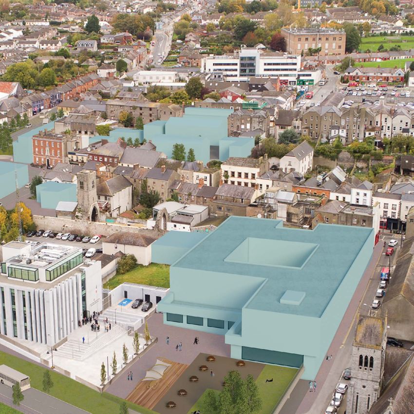
2
Cultural, Entertainment
& Recreation Cluster
Drogheda has a very strong cultural, arts and heritage Two potential pocket public spaces are identified for public realm
community, which is a positive anchor to develop. improvements at the eastern extremity of Narrow West Street (See Map
The area of Narrow West Street, Patrickswell Lane, Old 3.3). One at the Scholes Lane / Narrow West Street junction and one at
Abbey Lane and West Street has the highest density the Patrickwells Lane / Narrow West Street junction.
of pubs and restaurants. It is also the home of two of
the main activity centres - Droichead Arts Centre and
the Old Abbey Dance Centre.
Design Concept Two is to enhance and extend Old
Design Concept Two
Abbey Lane in an easterly direction to Dominic Street
across Patrickswell Lane. In a potential redevelopment
of the Abbey Shopping Centre. In tandem, the virtual
extension of the Lane to the west would comprise
a visual link to the chimney stack located within the
Donaghy’s Mill Study Area, which creates a desire line
from the Abbey Church to the lands on the other side
of the Bridge of Peace.
It is proposed to promote active uses onto the
extension of Old Abbey Lane.
FIG 3.4 Desire Line - Line of Vision to Donaghy’s Mill.
To realise the full potential of the WGV Area,
pedestrianisation of Narrow West Street is required in
order to facilitate the growth of Old Abbey Lane as
an entertainment /cultural cluster to counter-balance
commercial activity in the east quadrant of Drogheda
town centre.
PHOTO 3.4 EntertainmentPHOTO 3.5 Shop Street, Galway City
PHOTO 3.6 Old Abbey Lane PHOTO 3.7 Barlow House, West Street MAP 3.3 Re-imagining of pocket spaces in Narrow West
Street
Two new pocket spaces are possible in the phased
pedestrianisation of Narrow West Street (see Map 3.3).
The re-imagining of the existing space would enhance
the visitor experience at the gateway to West Street
providing a punctuation from the George's Square
Gateway to the commercial town core.
22 A Townscape Recovery Guide
For Property Owners, Investors and DevelopersA Townscape Recovery Guide 23
For Property Owners, Investors and Developers
3
New Homes = New Activation
= New Population
Drogheda historically had merchants living over their shops and more recently families lived above their business premises. The medieval
town was laid out as a series of oblong burgage plots to accommodate a family and a trade that extended back from a narrow street frontage.
The resident shopkeeper has departed in the last 50 years and the tradition has been lost. The loss of a resident community in the town core is
evident and is in contrast to areas such as the Cord Road adjacent to the centre where there is a vibrant resident population. Design Concept
Three is to attract people back into the urban core, especially in the commercial town centre in vacant space above businesses and to build
new homes on vacant land in the town centre.
Drogheda town centre has, in varying degrees high levels of vacancy above ground floor level and in the availability of vacant and / or
Design Concept Three
derelict lands. The lands in the town centre are not only serviced by essential infrastructure such as, water, sewerage and electricity, but
also with a multiplicity of other facilities including shops, schools and community infrastructure. There is an on-going housing crisis, but
potential residents need more than housing units. They need a comprehensive range of services and facilities to make homes. Drogheda has
the services and facilities to create new homes while new residents will support the sustainability of the existing town infrastructure, thus
safeguarding the future of Drogheda town centre.
PHOTO 3.8 New Town Centre Housing Waterford CityFig 3.5 Existing vacant section of O’Reilly’s Yard
FIG 3.6 Proposed mixed use/residential courtyards of O’Reilly’s Yard retail office residential
MAP 3.4 Proposed mixed use/residential courtyards at PHOTO 3.10 Barlow and Old Abbey Areas
O’Reilly’s Yard
PHOTO 3.9 Town Centre Housing Development
24 A Townscape Recovery Guide
For Property Owners, Investors and DevelopersA Townscape Recovery Guide 25
For Property Owners, Investors and Developers
4
Town Scale Public Space
The River Boyne has a significant part to which were likely civic spaces of their
play in the cultural heritage of Ireland. It can time. The opportunity to provide a public
be argued that the town of Drogheda like space south of the Abbey Shopping Centre
so many other towns has turned its back would have historical resonance and is
on the river. Drogheda does not have many the essence of Design Concept Four. The
public squares or civic focal points. The space would be slightly elevated above the
creation of a large, car free, urban space in existing ground level to provide undercroft
the town would be a significant addition to carparking and new buildings would
civic amenity and realise the activation of address and enclose the space, providing
Design Concept Four
the river promenade. active ground floor uses to animate this
area.
In 1753 Ricciardelli was commissioned to
paint Drogheda. The artist shows a large The new public space could be the iconic
flat space beside the river which looks like regeneration project within the WGV Area
a park or a private garden (See Fig 3.10). taking its example from Grand Canal Square
Ravells map of 1749 shows something which successfully brands the regeneration
similar located around Wellington Quay, of the Dublin Docklands.
FIG 3.7 Potential Town Scale Public SpacePHOTO 3.11 Old Abbey Area PHOTO 3.12 Oasis Project, Omagh, Co Tyrone
New Town Scale Public Space
A new town scale public space south of the Abbey Shopping Centre orientated
south is possible. The topography of the site could be used to marginally elevate
the space above river level to provide an undercroft public car park. A landscaped
civic space at podium level is possible, which would form a south facing terrace to
the river.
FIG 3.8 New Town Scale Public Space, Westgate
FIG 3.9 Potential Re-imagining of the Abbey Shopping Centre FIG 3.10 Extract of Gabriele Ricciardelli’s 18th century view of Drogheda
from Millmount
26 A Townscape Recovery Guide
For Property Owners, Investors and DevelopersA Townscape Recovery Guide 27
For Property Owners, Investors and Developers
5
Tourist/Residential Neighbourhood
& Riverside Promenade
Donaghy’s Mill Study Area by reason of its dereliction and its centre could utilise the existing underpass of the Bridge of Peace.
peripheral location is isolated at the western edge of the town, A new gateway building is proposed on the identified existing
segregated from the town core by the physical barrier of the opportunity site in the south-east corner of the Study Area.
Bridge of Peace. The Donaghy's Mill complex and adjacent vacant The underpass of the Bridge of Peace could access a new river
lands provide an opportunity to accommodate tourist facilities in promenade between the Mill buildings and the River Boyne.
proximity to the visitor gateway location of Westgate to include
hotel, hostel, visitor car parking, riverside restaurant, bicycle parking, By utilising the topography of the site it is proposed to provide
etc. visitor car parking in an undercroft car park below the level of
the Bridge of Peace. A potential hotel building would demarcate
Design Concept Five
It is possible to make the Donaghy's Mill complex and adjacent the arrival point to Drogheda from all directions. The scale of
vacant land’s accessible by utilising existing potential access points the building will reflect the landmark location of the existing
and by creating new access points from the Bridge of Peace and opportunity site which is identified in the Drogheda Borough
Trinity Street. A possible pedestrian/cycle route from the town Council Development Plan 2011 - 2017 (as extended).
FIG 3.11 Possible design concepts in Donaghy’s Mill Study AreaPHOTOS 3.13-3.17 Examples of Re-use, Adaptation & New-build in Dublin
PHOTO 3.13 PHOTO 3.14
PHOTO 3.15 PHOTO 3.16 PHOTO 3.17
28 A Townscape Recovery Guide
For Property Owners, Investors and DevelopersA Townscape Recovery Guide 29
For Property Owners, Investors and Developers
Urban Analysis - Westgate Vision Area
MAP 3.5 Landmark Locations and Features Identified in WGV AreaUrban Analysis
Westgate Urban
Study Area
Positive Anchors in
Westgate
A significant proportion of vacant land in Westgate is
in public ownership. The majority of the vacant lands
in Barlow and Old Abbey Study Areas are in State and
Local Authority ownership.
The existing historical, cultural, social and commercial
assets in the WGV Area may act as a catalyst for future
development (e.g. Droichead Arts Centre and Dance
Studio, Old Abbey Lane). The existing strong and
proactive community which supports commercial
operators and promotes rejuvenation within the area
PHOTO 3.18 Interior of Barlow House, Narrow West Street
is a potential for growth. Collectively, the existing
assets and potential for growth have the capacity to
realise the Vision for this area as the gateway to the
town of Drogheda and the visitor sites of the Boyne
Valley.
Barlow House
18th century Barlow House is home to a host of
cultural and community activities on a daily basis
including; classes in drawing, painting, drama,
photography, music, yoga, meditation, children’s art,
school grinds, flower arranging, and much more.
PHOTO 3.19 Exterior of Barlow House, Narrow West
Street
30 A Townscape Recovery Guide
For Property Owners, Investors and DevelopersA Townscape Recovery Guide 31
For Property Owners, Investors and Developers
Urban Analysis
Building Use and Vacancy in Westgate
Analysis of the existing buildings within the WGV Area shows that there is a diverse mix of ground floor uses.
The dominance of retail in the Old Abbey and Barlow Study Areas can be compared with the more dominant
residential use in the Donaghy’s Mill Study Area. However the level of vacancy of the retail units on Narrow West
PHOTO 3.20 Street is significant and indicates a challenging retail environment at the western extremity of the main shopping
Dance Studios,
Old Abbey Lane street in the town (West Street). The overall vacancy of the buildings in the WGV Area at ground floor level is 36%,
first floor level is 44% and second floor level is 70%. The high level of vacancy within the Donaghy’s Mill Study
Area is evidence of the redundant nature of the 19th century industrial building, emphasisng its predominant
derelict character.
PHOTO 3.21
Dance Studios,
Old Abbey Lane
Old Abbey Dance Studios
The dance studios on Old Abbey Lane are housed PHOTO 3.22 Old Abbey Area, Westgate
in a new building which respects the building line,
massing and height of existing structures on the Lane. In addition to building vacancy, the following figures show the level of vacant lands in the WGA Area. The
The studios are an event space within the historic vacancy levels (% of overall land not built upon) witnessed in the three Study Areas are as follows:
core of Drogheda that act as a destination creating
movement on the Lane as visitors enter and exit. The
Barlow Old Abbey Donaghy’s Mill
57% 74% 65%
building accommodates three contemporary 'state
of the art' dance studios, three music rooms and a
recording studio. The use of glass walling affords
transparency and supervision of the Lane while Such vacancy levels present considerable difficulties in retaining the vibrancy and vitality necessary for the
allowing internal views of the tower of the Old Abbey success of a town centre. Furthermore, there is the potential of such vacancy causing contagion into adjoining
Church. streets as existing or potential stakeholders may be deterred from improving or creating new investment
opportunities.Urban Analysis
MAP 3.7 Existing First Floor Uses
MAP 3.6 Existing Ground Floor Uses
Cultural In Use Office Vacant Retail In Use Industrial In Use
MAP 3.8 Existing Second Floor Uses.
Cultural Vacant Residential In Use Retail Vacant Industrial Vacant
Office In Use Residential Vacant Restaurant In Use Institutional In Use
Restaurant Office Institutional Vacant
32 A Townscape Recovery Guide
For Property Owners, Investors and DevelopersA Townscape Recovery Guide 33
For Property Owners, Investors and Developers
Urban Analysis
Vacant Land Potential
The ratio of vacant land to existing buildings is particularly high within the Old
Abbey Study Area. The Donaghy’s Mill and Barlow Areas also have significant
vacant land. The level of vacant land is confirmation of the townscape analysis
conducted as part of the Urban Design Framework Plan for the Heritage Quarter,
Drogheda (2013), which identified Westgate and its environs as an area requiring
comprehensive intervention in order to recover its townscape coherence. The
availability of vacant land affords the opportunity of potential redevelopment and
townscape recovery.
Architectural Conservation Areas &
Protected Structures
The significance of heritage in the WGV Area is evidenced in the wealth of
Protected Structures, ACA’s, National Monuments and Zone of Archaeological
Interest, all of which contribute to the character of the area. It is acknowledged that
the methodology applied in the renovation/ repair and reuse of existing buildings
coupled with the respectful relationship between historic and new buildings is
pivotal in the successful implementation of the Townscape Recovery Guide.
Landscape & Vistas
The key views and vistas are defined in the Framework Plan and these should be
preserved and enhanced. They are from the Bridge of Peace in both directions
along the Boyne River and towards the Old Abbey Study Area to the north of the
river. The identification of these views recognise the Boyne River as Drogheda’s
primary natural asset as well as highlighting the need to enhance and promote its
potentially significant contribution to the surrounding vicinity. The medieval town
wall is another distinctive feature in the WGV Area which should be highlighted
and showcased as a visitor attraction, utilising the existing green space between
the Bridge of Peace and the town wall and the open area at Murdock’s Yard. Other
key landmarks in the WGV Area the chimney at Donaghy’s Mill and the Old Abbey
Tower.
PHOTO 3.23 Old Abbey Lane, WestgateUrban Analysis
FIG 3.12 Existing Section AA Topography
The natural topography of the WGV Area is
characterised by the gradual and then more rapid
uplift of terrain from the north bank of the River
Boyne to a ridge line in the location of Fair Street.
Drogheda’s medieval street pattern is influenced
by the steep topography and the curve of the River
Boyne. The town is laid out in a series of terraces
facing south, giving rise to sunlit streets north-south
(Peter Street, Duke Street, Scholes Lane, Patrickswell
Lane), intersected by a longer curved street east-west
and often in shade (West Street) (Fig 3.12).
FIG 3.13 Existing Section BB
The above section from west to east (Fig 3.13) shows
the natural topography of the north river bank as
a flat flood plain, which comprises in built form a
consistent scale and height of development. The
maximum height of development is predominantly
four-storey capped by traditional pitched roofs.
MAP 3.9 Topography of Westgate
34 A Townscape Recovery Guide
For Property Owners, Investors and DevelopersA Townscape Recovery Guide 35
For Property Owners, Investors and Developers
Urban Analysis
Connectivity & Mobility
This map shows potential public space improvement
opportunities within the Heritage Quarter. A number
of these opportunities are within the WGV Area.
To promote urban living, traffic management
improvements for pedestrians and cyclists to
enhance non-vehicular connectivity and mobility
may be considered. For example George’s Square is
dominated by traffic and disconnects Trinity Street
from the town centre. Similarly, the Bridge of Peace is
a significant north-s outh link prioritising vehicular
transport over the pedestrian and cyclist.
A re-use of the existing bridge linking Dominic
Street to the south bank of the River Boyne is shown
highlighted and should be investigated as a long
term traffic management possibility.
The River Boyne is at the heart of the town of
MAP 3.10 Connectivity and Mobility in wider Drogheda Town Centre area
Drogheda, but it both divides and connects urban
space. Enhanced riverside walks/cycle ways for Walking/Cycle Path Planned Path Public Spaces/ Framework Plan for the
residents and visitors are possible as part of quality Heritage Quarter Drogheda 2013
urban landscaping. The map highlights the potential
for river walk/cycle ways on the north and south
bank of the Boyne and their extension into the The potential to link east to Mornington using the There is scope within the WGV Area to extend
western hinterland. north bank of the river to allow the Mornington the natural qualities of the River Boyne corridor. A
River walk/cycle way traverse the WGV Area is also a detailed landscape plan which would prioritise tree
possibility. planting and soft landscaping within the urban core
would enhance the quality of urban space in the
town centre. Potential areas for improvement are
highlighted in the following section (Fig 3.14).Availability of Vacant Land Opportunities
O'Reilly's Yard is a good
example of the vacant lands
between Narrow West
Street and Fair Street.
FIG 3.14
Section showing potential areas for improvement
Murdock's Yard is currently being
O'Reilly's Yard is suffering from
used as a car park facing the
the lack of permeability through
extensive remains of the medieval
Drogheda town centre
town walls of Drogheda.
36 A Townscape Recovery Guide
For Property Owners, Investors and DevelopersA Townscape Recovery Guide 37
For Property Owners, Investors and Developers
Conclusion of Urban Analysis: Westgate
Occupancy Uncovered
The urban analysis reveals that within the WGV Area there is significant opportunity for investment. Approximately 1/3 of the land area is vacant, another 1/3
accommodates underutilised and derelict buildings requiring refurbishment and the residual 1/3 accommodates buildings occupied and viable.
Barlow
Study Area
Donaghy’s Mill
Study Area
Old Abbey
Study Area
⅓ ⅓ ⅓
Existing NEW BUILD REFURBISHMENT
MAP 3.11 Urban Analysis Occupancy Map, Westgate38 A Townscape Recovery Guide
For Property Owners, Investors and DevelopersPA R T I I I | RECOVERY | 39 BARLOW AREA RESPONSE
FIG 3.15 Possible Conservation / Intervention      FIG 3.16 Proposed Ground Floor Uses                            FIG 3.17 Proposed First Floor Uses

                                                                                 KEY
             Barlow Area Analysis                                                                                            Office                             Retail
                                                                                         Conservation
                                                                                         Intervention                        Residential                        Restaurant / Hotel
             Conservation / Intervention                                                 Cultural                            Institutional                      Parking

             Figure 3.15 shows the relationship between the existing
             historic fabric and potential new buildings within the
             Barlow Study Area. A pivotal consideration will be the
             repair, renovation and reuse of existing buildings and the
             relationship of new buildings with the historic buildings
             in terms of location, scale and building form. All new
             buildings and extensions to existing buildings shall
             exhibit a high quality design in terms of their built form
             and material finish.

             Proposed Ground Floor Uses
                                                                                                                                                                           Proposed Section AA
             Figure 3.16 shows an indicative ground floor land use
             strategy for the Barlow Study Area comprising active
             use at the edges onto George’s Square and Scholes
             Lane with residential use in the interior. A cultural use is
             proposed to the rear of Barlow House that would build                                                                                                         Proposed Section BB
             on its existing cultural uses and reinforce the south-west
             quadrant of the Study Area as a cultural cluster.

             Proposed First Floor Uses
                                                                                  FIG 3.18 & FIG 3.19 Illustrates the relationship between historic fabric and potential new buildings in the WGV
             Figure 3.17 shows indicative first floor uses for the Barlow         Area

             Study Area. Use could be mainly residential in nature,
             complementing the primarily residential ground floor
             use.

40   A Townscape Recovery Guide
     For Property Owners, Investors and Developers
A Townscape Recovery Guide 41
For Property Owners, Investors and Developers
Barlow Area Possibilities
There is an opportunity to investigate the
development of an infill housing scheme within
the interior of th Barlow Study Area (See Fig 3.20)
potentially with non-residential active use at ground
floor level in strategic locations, for example, at the
edges of the urban block where it interfaces with
George’s Square and Scholes Lane.
The diagram (Fig 3.20) shows an indicative footprint of
an infill housing scheme in the vacant lands between
Narrow West Street and Fair Street. The configuration
of the new-build is dictated by the objective to create
permeability for the public through the block. The
overall vision is to respect existing building scale and
fabric to provide infill housing grouped around semi-
private internal courtyards linked to the principal east-
west public route through the Study Area.
The section drawing and plan shows the opportunity
to provide quality housing while achieving
FIG 3.20 Indicative footprint of infill housing in Barlow Study Area
permeability through the Study Area from George’s
Square to Scholes Lane.
FIG 3.21 Possible opportunity to provide quality housing while achieving permeability in Barlow Study Area, Westgate
PHOTO 3.24 Good quality housing possible while achiev-
ing permeabilityFIG 3.22 Possible Connectivity Improvements FIG 3.23 Possible Mobility Improvements FIG 3.24 Possible Landscape Improvements
KEY
Primary Connections Public Courtyard
Secondary Connections Semi-public Green Areas
Accessible Laneways Private Road Granite Setts (cobblestones)
Public Realm Analysis
Connectivity Existing & New Connections Landscape
The redevelopment of vacant lands within the The diagram clearly shows the potential public There is an opportunity for a network of new
interior of the Barlow Study Area would facilitate space achievable within and bounding the public/semi private hard and soft landscapes within
east / west movement between George’s Square Barlow Study Area, greatly enhancing pedestrian the interior of the Barlow Study Area. The proposed
and Scholes Lane and north-south movement movement. semi-private public spaces are shown indicatively in
between Fair Street and Narrow West Street. The the diagram as a network of landscaped recreation
north-south links will intersect with the primary areas. These spaces would provide the residential
east-west spine at a number of locations creating amenity open space for the proposed infill housing
a network of pedestrian routes within the Study scheme to be constructed between Narrow West
Area. However potential access points onto Street and Fair Street.
George’s Lane, Narrow West Street and Fair Street
will need to be negotiated with landowners.
42 A Townscape Recovery Guide
For Property Owners, Investors and DevelopersA Townscape Recovery Guide 43
For Property Owners, Investors and Developers
Public Realm Possibilities
A comprehensive redevelopment opportunity within
the interior of the Barlow Study Area is possible where
development could be applied for under the relevant
Development Plan on vacant lands between Fair
Street and Narrow West Street. A redevelopment of
these lands would unlock finite serviced urban land
while creating access to the interior and movement
through the Study Area where there is currently
limited permeability.
The creation of new pedestrian routes / lanes and
public spaces would potentially provide a visitor
pathway to the town centre through the Barlow
Study Area linking a proposed tourist bus set down/
visitor stop off point on George’s Square to Scholes
Lane and beyond.
Pedestrianisation on the southern edge of the Barlow
Study Area would fully realise the potential of the
WGV Area as an entertainment/cultural/recreation
cluster to act as a counter-balance to activity in the
east of Drogheda town centre.
Fig 3.25 identifies a number of public realm
enhancements that are proposed.
FIG 3.25 Possible Public Realm Enhancements, Barlow Study AreaGeorge’s Square Visitor Access & Traffic Calming Semi-Private Residential Amenity Spaces
The creation of a network of semi-private public spaces within the interior of the
George’s Square could become the principal arrival point to the town centre for the
Barlow Study Area in tandem with the redevelopment of vacant lands between
visitor and a gateway location to access the Boyne Vallley heritage sites.
Narrow West Street and Fair Street for quality homes is possible.
There is potential to reconfigure George’s Square to reflect its gateway status. A note
median or traffic island across the existing traffic intersection would significantly The remains of the town wall north of Narrow West Street may be further back (that is east
improve pedestrian movement. The eastern section of George's Square could be of the building line on George’s Square) than previously thought – see Figure 5.15 of the
Heritage Quarter Framework Plan. This may have implications for the possible location of a
re-imagined as setdown for tourist buses.
new terrace of buildings, which could define the western boundary of the Barlow Study Area
The further development of the gateway concept could investigate the enclosure onto George’s Square.
of the Bridge of Peace / George's Square to form an urban street. A hard built edge
to the carriageway alignment subject to conservation constraints is possible.
East / West Tourist Route
A new east-west pedestrian route from George’s Square to Scholes Lane through
the Barlow Study Area is a possible new tourist trail to the town centre. There is also
the possibility of new north / south connections between Narrow West Street and
FIG 3.26 Re-imagining of the Public Realm, Westgate
Fair Street.
Narrow West Street
Pedestrian Zone
The pedestrianisation of Narrow
West Street would realise the full
potential of the WGV Area as a tourist/
entertainment/cultural cluster.
New Public Spaces
Two new pocket public spaces are
possible at the junction of Scholes
Lane / Narrow West Street and at
the junction of Patrickswell Lane /
Narrow West Street (see Old Abbey
Study Area) creating a clearly defined
pedestrian link from the WGV Area to
the commercial town core.
44 A Townscape Recovery Guide
For Property Owners, Investors and DevelopersYou can also read