TOWN OF MONTREAL WEST URBAN PLANNING PROGRAMME - Adopted on June 30th, 2009
←
→
Page content transcription
If your browser does not render page correctly, please read the page content below
TOWN OF MONTREAL WEST

URBAN PLANNING PROGRAMME

      Adopted on June 30th, 2009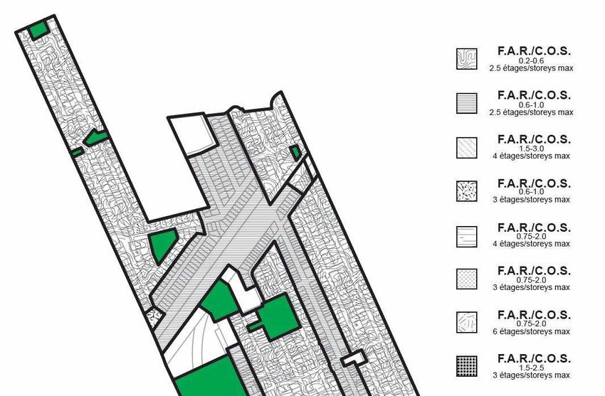
TABLE OF CONTENTS

List of Illustrations.........................................................................................................................3
Introduction.......................................................................................................................................4

Chapter 1 - A VISION FOR MONTREAL WEST
  1.1   Policies, Priorities and Constraints...........................................................................................6
  1.2   Geography, History and Demographics……………….........................................….…...8
  1.3   Adoption of the Programme ………………………….…...............................................10
  1.4   How to interpret the Implementation Tables.......................................................................12

Chapter 2 - TOWN CENTRE REVITALIZATION
  2.1 Background................................................................................................................................13
  2.2 Planning Objectives:
        Objective 1: Create a unifying urban design for the downtown core...........................15
        Objective 2: Beautify and improve the town centre........................................................20
  2.3 Implementation………………..............................................................................................21

Chapter 3 - LAND-USE AND ZONING CHANGES
  3.1 Background…………..............................................................................................................23
  3.2 Planning Objectives:
        Objective 1: Attract desirable uses....................................................................................23
        Objective 2: Harmonize building height, setbacks and density in the town centre..24
  3.3 Implementation.........................................................................................................................26

Chapter 4 - INFRASTRUCTURE RENEWAL
  4.1 Background................................................................................................................................29
  4.2 Planning Objective: Improve the town’s physical infrastructure......................................29
  4.3 Implementation.........................................................................................................................30

Chapter 5 - TRANSPORTATION AND TRAFFIC MANAGEMENT
  5.1 Background................................................................................................................................31
  5.2 Planning Objectives:
        Objective 1: Improve the management of vehicular traffic..........................................34
        Objective 2: Create pleasant, safe and efficient pedestrian links between the
                       various points of interest in town.............................................................35
        Objective 3: Improve and expand parking in the town centre.....................................36
  5.3 Implementation.........................................................................................................................36

                                                                      -1-
Chapter 6 - NEIGHBOURHOOD LIFE
 6.1 Background................................................................................................................................38
 6.2 Planning Objectives:
       Objective 1: Make residential areas safer and quieter.....................................................38
       Objective 2: Encourage property maintenance and renovation...................................39
 6.3 Implementation.........................................................................................................................40

Chapter 7 - IMPROVED FACILITIES AND SERVICES
 7.1 Background..............................................................................................................................41
 7.2 Planning Objectives:
       Objective 1: Consolidate municipal services....................................................................41
       Objective 2: Promote the construction of a seniors’ residence.....................................42
       Objective 3: Improve existing green spaces and parks...................................................42
       Objective 4: Upgrade or replace the arena.......................................................................43
 7.3 Implementation.........................................................................................................................44

Chapter 8 - GREEN PLANNING
 8.1 Background................................................................................................................................45
 8.2 Planning Objectives:
       Objective 1: Improve energy efficiency and waste management..................................45
       Objective 2: Promote alternative modes of transportation...........................................46
       Objective 3: Preserve and enhance existing green spaces and encourage the
                        preservation of Meadowbrook.................................................................47
 8.3 Implementation.........................................................................................................................47

Conclusion………............................................................................... ..........................................49

Appendix A: 2004 Montreal Master Plan – Land Use Designation Map...............................50

                                                                    -2-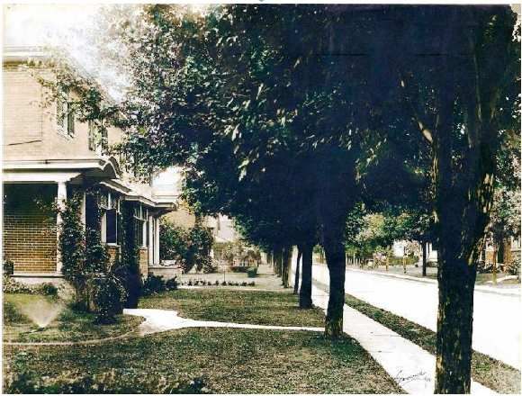
LIST OF ILLUSTRATIONS
Cover page:   Train photo (Montreal West Museum)
              Westminster North photo (Town Planning Committee, 2008)

Fig 1: Montreal West’s location on the Island of Montreal, p. 8
       (Ville de Montréal, Système d’information urbaine de référence spatiale, 2005)

Fig 2: Strathearn Avenue in 1918, p. 9
       (Gladwish and Mitchell, 1918)

Fig 3: Map of town centre, p. 14
       (maps.google.com, 2009)

Fig 4: Concept sketch of the planned Community Recreation Complex annex to Town
       Hall, p.16
       (Town Planning Committee, 2008)

Fig 5: Concept sketch of commercial district on Westminster North after planned
       changes, p. 18
       (Town Planning Committee, 2008)

Fig 6: Concept sketch of level crossing with potential improvements in the event that
       railway tracks are buried by transport authorities, p. 19
       (Town Planning Committee, 2008)

Fig 7: Concept sketch of zoning changes on Westminster South, p.25
       (Jan Davis, architect, 2009)

Fig 8: New land use designation map, p.27
       (Town Planning Committee, 2008)

Fig 9: New density map – Floor-area ratio and building height, p.28
       (Town Planning Committee, 2008)

Fig 10: Level crossing at Westminster and Sherbrooke, looking north over the tracks,
        p. 32
       (Town Planning Committee, 2008)

Fig 11: Street hierarchy in Montreal West, p.33
       (Town Planning Committee, 2008)

Appendix A: 2004 Montreal Master Plan – Land Use Designation Map, p. 50
            (Ville de Montréal, 2004)

                                          -3-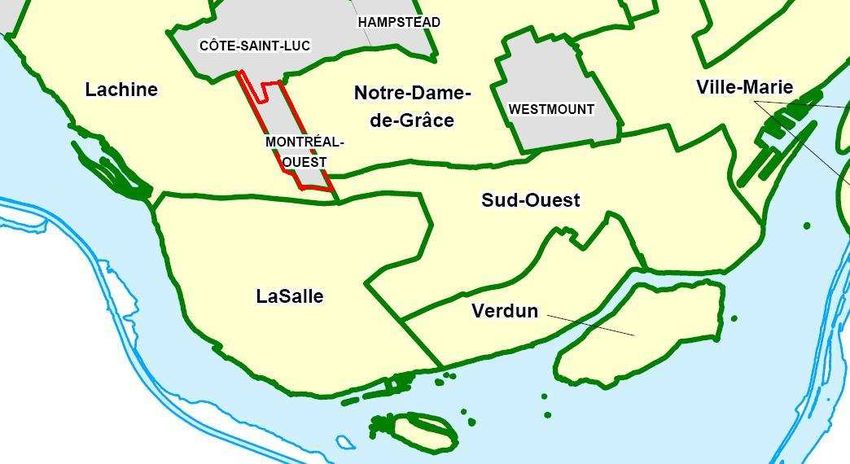
INTRODUCTION

Montreal West is a small-town gem located in the heart of the Island of Montreal. Having
celebrated the town’s 100-year anniversary in 1997, residents continue to enjoy the mature
canopy of trees gracing streets and parks, quiet family-oriented neighbourhoods, the fine
architecture of their homes, a wide variety of municipal services and facilities, and a thriving
commercial street.      Montreal West’s centralized location with convenient access to
downtown Montreal, highways, the airport, and public transportation contributes to the
town’s desirability. Despite its small-town feel, Montreal West is part of the closely-knit
collection of municipalities and Montreal boroughs that make up the greater Montreal urban
area. As such, the town is facing increasing traffic on its residential streets and development
pressure from surrounding areas. Furthermore, Montreal West is currently confronting a
number of planning challenges. Principal among these are a major multi-year infrastructure
reconstruction program, a focus on sustainable development, and the need to renew
municipal facilities.

The Town Planning Committee was set up in February 2007 following the demerger from
the City of Montreal to assist Town Council in planning matters. It quickly became apparent
that the Master Plan prepared by the City of Montreal in 2004 was no longer relevant to the
reconstituted town (see Appendix A for an illustration), and left decision-makers without the
necessary tools to address the challenges now facing it.

It has been necessary to develop a vision for Montreal West that reflects today’s planning
context and imperatives. At the same time, residents appreciate the town’s unique history
and its community assets and they do not wish to see radical change alter its small-town
nature and sought-after quality of life. This Urban Planning Programme is therefore a
compromise. It seeks to accommodate change while retaining the town’s character and
making Montreal West an even better place to live, work and play.

                                             -4-
The vision encompasses these objectives:
   1. Fostering a more vibrant, viable and diversified town centre as the focal point of the
       town’s civic, commercial and cultural affairs.
   2. Renewing outdated municipal infrastructure including streets, sidewalks, sewers and
       water mains.
   3. Modifying land-use and zoning regulations to accommodate the objectives of this
       Programme and best practices generally.
   4. Improving the street network to ensure safe and efficient access to major arteries and
       public transportation, as well as adequate parking for shoppers.
   5. Enhancing neighbourhood life by improving tranquility, ensuring the safety of
       children, pedestrians and cyclists, and preserving the town’s architectural heritage.
   6. Making Montreal West a more senior-friendly environment.
   7. Improving major community facilities in a phased, cost-neutral manner.
   8. Adopting environmentally sustainable policies for activities and development in both
       public and private domains.

The Town of Montreal West does not operate in isolation. Success in our endeavours will
also depend on maintaining good relations with neighbouring municipalities, regional entities
and governments, both to influence the planning of outside projects that may affect the
town and to secure resources for our own initiatives.

Our financial resources are limited and many of our planning initiatives will take a number of
years to realize. This Urban Planning Programme is designed to give us the tools to refine
and implement changes over time as funds become available.

Most importantly, our long-term success depends on harnessing our greatest asset: the input
and energy of an active citizenry dedicated to improving public services and nurturing our
community spirit. This Urban Planning Programme belongs to them.

                                             -5-
Chapter 1
               A VISION FOR MONTREAL WEST

1.1 POLICIES, PRIORITIES AND CONSTRAINTS

This Urban Planning Programme identifies and prioritizes a number of long-term objectives
for Montreal West, and dedicates a chapter to each of them. They are:
   -   Town Centre Revitalization
   -   Land-Use and Zoning Changes
   -   Infrastructure Renewal
   -   Transportation and Traffic Management
   -   Enhancing Neighbourhood Life
   -   Improving Municipal Facilities and Services
   -   Green Planning

The selection of these objectives was based on the following policy decisions:
   -   To increase the profitability of our business community, and with it town revenues
   -   To fix our infrastructure before further deterioration raises both costs and risks
   -   To improve our municipal facilities over time, prioritizing cost-neutral projects
   -   To enhance the integrity of neighbourhoods as the key to improving quality of life
   -   To put pedestrian and resident safety above the needs and convenience of drivers
   -   To anticipate and address the needs of an aging population
   -   To reduce our environmental footprint
   -   To keep costs as low as possible

The implementation of objectives is conditioned by the political and financial realities facing
Montreal West. Most important of these is the fact that municipal taxes are already high,
and that any increase would be hardest on seniors and may depress real estate values
generally. The Town must therefore plan only expenditures that are necessary, such as
infrastructure renewal, and the realization of the rest of these objectives must proceed on a

                                             -6-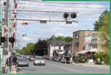
cost-neutral basis or wait until new funds become available. This Programme therefore
provides the regulatory framework for realizing its goals over an extended period of time.
No expropriations are contemplated. Implementation will be an ongoing process of
incremental changes leading to results over time, as objectives are refined and realized
through consultation and detailed design.

Planning is also conditioned by outside developments which, while affecting the Town and
its decision-making, are not under its control.     These include the ongoing Parmalat
expansion on our south-east border, the proposed reconstruction of the Turcot Interchange
and Highway 20 to the south, the proposed airport shuttle that may cut across town on the
CPR right-of-way, and plans for a large-scale residential development on Meadowbrook golf
course.

As a small municipality, the Town of Montreal West is particularly susceptible to forces
beyond its borders and our wellbeing depends on our success in fostering a wider
community of respect and cooperation. To this end, we have to actively engage with and
promote good relations with neighbouring municipalities as well as with regional entities
such as the Agglomeration and the Montreal Metropolitan Community (MMC), the
provincial and federal governments, non-governmental organizations and the private sector.

Ultimately, this Urban Planning Programme can only succeed with the concerted effort of all
stakeholders. As in the past, Montreal West will always count on the input and energy of an
active citizenry dedicated to improving public services and the quality of life of our
community.

                                            -7-
1.2 GEOGRAPHY, HISTORY AND DEMOGRAPHICS

The Town of Montreal West is located approximately 10 kilometres west of downtown
Montreal on an elevated escarpment (the Falaise St-Jacques) that begins at Montreal West’s
western edge and extends several kilometres east to St-Henri. The Town is bordered by the
Borough of Côtes-des-Neiges - Notre-Dame-de-Grâce to the east, the Borough of Lachine
to the west and south, and the City of Côte Saint-Luc to the north (Figure 1 over).

Fig. 1. Montreal West’s location on the Island of Montreal.

Railway tracks split the municipality into three informal districts: the South, the Centre and
the North. The north part (contiguous with Côte Saint-Luc) is connected to the rest of the
town by a two-lane bridge. The east-west Canadian Pacific Railway (CPR) commuter line
cuts right through the centre of Montreal West and crosses Westminster Avenue, the main
commercial street, at a level crossing. In addition to the railway tracks, other physical
barriers exist which define the town’s borders and structure. To the south is Highway 20,
with Notre-Dame Street marking the southern boundary. To the south-west, development
is restricted by the steep escarpment above the Saint-Pierre area of Lachine.

The “garden suburb” of Montreal West was incorporated in 1897. The original town
consisted of approximately 400 acres (1.41 km2), which remains its current size. Although
development in the territory began in 1653 when the Decarie family settled in the area, the
                                                  -8-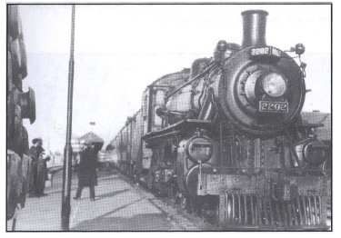
existing layout of the garden community started to take form in the mid-1890s when
Toronto-based developers began servicing and selling residential lots. The town grew from
a small population of 350 to reach 3,474 at the end of World War II. By the late 1950s
virtually all of the town’s territory had been developed. Today, approximately 5,300 people
live in the Town of Montreal West.1

    Fig. 2. Strathearn Avenue in 1918.

The town is primarily residential, containing mostly single-family homes (Figure 2). Sixty-
four percent of dwellings are either detached or semi-detached, compared to 37% for the
City of Montreal.2 A substantial proportion of the housing stock is old and of rich
architectural quality.3 Almost half of the 1,855 private dwellings in Montreal West were built

1 Statistics Canada’s 2006 Census counted 5,184 inhabitants.
2 Statistics Canada, Canada Census, 2006.
3 Several homes have received the annual award given by “Maison coup de coeur du public”, Opération patrimoine

  architectural de Montréal.

                                                        -9-
before 1946 and most of the rest before 1986.4 Furthermore, the rate of homeownership is
high, with more than three-quarters of dwellings owned by their occupants, versus a
Montreal average of 53%.
The median age of the population is 41.7, slightly higher than that of the Montreal Census
Metropolitan Area (CMA). School-aged children and young adults of CEGEP age represent
23.2% of the population whereas people over 65 comprise 12.8% (almost 45% of this group
is over 75). The average household size is 2.8, down from 2.9 per household in 19865.
Declining household size indicates the trend toward smaller families and an aging
population. The population of Montreal West is very stable, with over 90% of residents
living at the same address the year before and 74% living at the same address five years ago.
Montreal West is predominantly an English-speaking community, where English is spoken at
home in about 80% of households. However, French is now spoken in 12.5% of
households, doubling since 1986. Three-quarters of residents consider themselves bilingual.6
The Town of Montreal West is a cohesive community that supports a wide variety of
services and activities. According to the results of a community-wide survey in late 20077,
the majority of citizens place a high value on the sense of community, congeniality and
tranquility of the town. Resident involvement in municipal affairs is very high. There are a
number of volunteer committees working in areas such as planning, traffic and safety,
environmental action, sports and recreation, and architectural integration. Service groups,
such as the Rotary Club, Scouts and others, are very active in the community as well.
1.3 ADOPTION OF THE PROGRAMME
In November 2004, when the Town of Montreal West was part of the City of Montreal, the
latter adopted a Master Plan covering the whole Island of Montreal. That Master Plan
replaced the Urban Planning Programme adopted by the Town in November 1990 (By-law
4 Statistics Canada, Canada Census, 1986.
5 Statistics Canada, Canada Census, 2006.
6 Statistics Canada, Canada Census, 2006.
7 Town Planning Committee, Community Survey, distributed in September 2007 and compiled in November 2007.
- 10 -445). When the Town was reconstituted at the beginning of 2006, the provincial
government chose to maintain the City of Montreal’s Master Plan for the demerged
municipalities, subject to their right to amend their portions going forward.
In 2007, Montreal West formed a Town Planning Committee (TPC), chaired by Mayor
Campbell Stuart and composed of local residents and municipal employees.8 The TPC
undertook to draft an Urban Planning Programme which reflects current local interests and
concerns, including the revitalization of the town centre, the enhancement of
neighbourhood quality of life and the promotion of sustainable development.
This Urban Planning Programme amends Montreal’s 2004 Master Plan. Although the Town
is not legally permitted to replace the Master Plan until mid-2010, it may modify it in the
interim. Accordingly, this modifies the sections of Montreal’s Master Plan (By-law 04-047),
pertaining exclusively to Montreal West.9 It may eventually have to be revised to conform to
the Metropolitan Land Use Planning and Development Plan (MLUPDP), in the event that
the latter is adopted by the Montreal Metropolitan Community (MMC).10
This Urban Planning Programme was prepared by the TPC and has been approved in its
present form by the Municipal Council of Montreal West. It has been prepared according to
the requirements of the Act Respecting Land Use Planning and Development with regard to
its content. In preparing this document, the residents of Montreal West were invited to
share their views and suggestions, ask questions and voice concerns at two public
consultations, on May 20 and June 9, 2009.11
The adoption of this Urban Planning Programme represents the first concrete step towards
realizing the vision outlined in its pages. Many of the Programme’s objectives will continue
to be refined through discussion and consultation and their ultimate realization shall be
subject to cost analysis and, where necessary, engineering studies. In many cases proposed
8 Members of the Town Planning Committee are Raymond Beshro, Tim Goforth, Ron Hasid, Patrick Mann, Campbell
Stuart and Julie Tasker-Brown, with assistance from the planning firm Groupe Gauthier Biancamano Bolduc. The TPC
would especially like to thank Jan Davis, a resident and architect who consulted extensively on this document.
9 This section can be viewed at www.ville.montreal.qc.ca
10 A draft version of the MLUPDP was adopted in February 2005 and submitted for public consultation. The MMC is
presently working on a revised version of the plan.
11 Although the Act Respecting Land Use Planning and Development requires only one public consultation the Town
elected to hold a second session to enhance public participation in the planning process.
- 11 -projects will also be subject to the established approval processes of the Planning Advisory
Committee and Municipal Council, as well as specific architectural guidelines.
1.4 HOW TO INTERPRET THE IMPLEMENTATION TABLES
The following chapters describe the objectives of the Urban Planning Programme both in
general terms and by identifying specific actions. The Implementation Tables at the end of
each chapter identify priority levels as well as approximations of time frames and cost levels
for each action.
Time Frames: The time frame for implementing some actions is “ongoing”. For other
actions a range of years is given, although it should be noted that these are
only approximations.
Cost Levels: The cost indicators for each action are also approximations, qualified as
follows:
Low - could probably be covered in an annual operating budget
Medium - would need to be specifically budgeted in advance
High - would require a borrowing by-law with extended repayment
- 12 -Chapter 2
TOWN CENTRE REVITALIZATION
2.1 BACKGROUND
The centerpiece of this Urban Planning Programme is the Town Centre Revitalisation Plan
(“the Revitalization Plan”). The goal is to create a viable, vibrant and active commercial core
which will improve the quality of life for residents and expand the town’s tax base.
Montreal West is endowed with a traditional main street, Westminster Avenue, which is
populated by a core of successful businesses that primarily serve local residents. At present,
commercial activity is focussed on the block between Sherbrooke and Curzon although
some businesses are located further north and south along the street. Many reminders of the
town’s rich history are located just south of this area, including the Block Tower, Royal West
Academy, the Montreal West Train Station, Town Hall, and Memorial Park with its
monuments. The commercial district is centrally located in the municipality with access to
the train station and with a considerable amount of through traffic.
When used herein, the terms “town centre” and “commercial sector” refer to the same
geographical area, comprised of:
-Westminster North, from Curzon to Sherbrooke;
-Westminster South, on the east side, from Broughton to Avon; and
-Milner, on the south side, from Westminster to Wolseley.
For ease of reference, a current map of this area is given in figure 3 on the next page.
- 13 -Fig 3. Map of town centre
2.2 PLANNING OBJECTIVES
OBJECTIVE 1—Create a unifying urban design for the downtown core
A successful town core starts with a sense of place, a destination. However, the existing
streetscape on Westminster, both north and south of the tracks, is architecturally incoherent
and full of unused and underutilized spaces. This street presents substantial potential for
commercial and residential projects. The improvement areas contained in the Revitalization
Plan have a number of aims, including: addressing problems with the physical appearance of
Westminster, attracting new investment, expanding the tax base, increasing the variety of
housing available, mitigating unwanted impacts of development, and consolidating municipal
- 14 -and community services. The Revitalization Plan includes four “Detailed Planning Areas”,
which will be the focus of zoning revision and municipal investment. No expropriations are
contemplated.
1) Town Square/New Community Recreation Complex
The heart of the Revitalization Plan is the transformation of the Davies Park area into a
town square. The new town square will attract development south of the tracks, increase its
appeal as a destination, enhance its value as a pleasant and functional green space for
community activities and events, and provide pedestrian links between the train station,
Royal West Academy and the Community Recreation Complex described below.
The town square development will be carried out in concert with the consolidation of
municipal services such as the community centre and library in a new Community Recreation
Complex to be housed in an annex to the Town Hall (Figure 4). The new building will
replace the existing facilities which are badly in need of repair and updating to meet the
needs of residents better. Given the overriding priority of modernizing the town’s
infrastructure, this project will only be pursued in the near term if grants and the use and sale
of municipal land make it a low- or no-cost solution. In addition to federal and provincial
funding, grants will also be sought for incorporating “green” technologies into the
development. Such a green project will optimize the use of land in the center of town and
yield economic benefits to the community by lowering operating and maintenance costs.
- 15 -Fig 4. Concept sketch of the planned Community Recreation Complex annex to Town Hall.
2) Westminster South Improvement Area
Westminster South has been the focus of redevelopment plans since the 1960s. Through the
objectives set forth in this Revitalization Plan, the Town will act as facilitator in the
improvement of this important stretch of Westminster. To this end, the Town hopes that
projects such as a new Community Recreation Complex, re-landscaping of Davies Park and
the beautification of Westminster North will spark private investment on this block.
Furthermore, the Town will encourage the private construction of medium-density mixed-
use structures (as described in Chapter 3) on the east side of Westminster South, while
preserving the west side for municipal buildings and public open space (Figure 5). This will
make more efficient use of scarce land, create a more viable commercial area, expand the tax
base and help address the need for a greater variety of housing options particularly for
seniors and young householders.
- 16 -The municipally-owned land at the corner of Avon and Westminster (John A. Simms Park
and the site of the existing library building) will be made available for a possible seniors’
residence (see Section 7.2, Objective 2) because it affords the Town a certain amount of
control over its development. This does not preclude the selection of other suitable sites for
a seniors’ residence that may become available.
Pedestrian safety at the five-point intersection of Avon and Westminster must be improved
as well, in light of traffic patterns as they currently exist and as they may evolve in response
to the other changes proposed on Westminster South. (see Section 5.2 for further details).
3) Westminster North
The existing commercial block on Westminster between Sherbrooke and Curzon will get a
much-needed facelift. In addition to the measures delineated in Objective 2—Beautify and
improve the Town Centre—the Town will put measures in place to enhance the physical
appearance of the commercial district by encouraging appropriate new infill development
and rehabilitating historic buildings to create a contiguous unified streetscape on the main
street (Figure 5). Zoning provisions related to building height will remain unchanged for this
block.
- 17 -Fig 5. Concept sketch of commercial district on Westminster North after planned changes.
4) Level Crossing
A number of changes at and around the level crossing are envisaged. The primary aim is to
improve safety (see Section 5.2). In addition, this area will be the target of a number of
improvements if the airport shuttle does eventually run through the town and all the tracks
are buried. In this event, safer and more attractive pedestrian links can be created between
north and south Westminster, and will also facilitate the development of a focal point such
as a farmers’ market, and the introduction of additional parking and new green walkways
along the tracks (Figure 6). In the event that the tracks are indeed buried, the Town would
sponsor a design competition to find the best solution possible for the reconfigured area.
The resulting improvements would not only enhance civic pride among Montreal West
residents, they would also help current and future businesses based in town thrive and grow.
- 18 -Fig 6. Concept sketch of level crossing with potential improvements in the event that the railway tracks are
buried by transport authorities
ACTIONS
2.1.1 Redesign and landscape what is now Davies Park into a town square to
enhance it’s role as a focal point and gathering space for the community.
2.1.2 Develop measures to encourage and facilitate the subdivision and
amalgamation of under- and unutilized lots along Westminster Avenue
between Curzon and Avon.
2.1.3 Undertake the physical and visual integration of the north and south portions
of Westminster, with a focus on ensuring safe and attractive pedestrian links
across the railroad right-of-way.
2.1.4 Revise zoning regulations on the east side of Westminster South to permit an
increase in density in mixed-use structures while mitigating adverse impacts
- 19 -on rear properties such as unwanted views and shading (as described in
Section 3.2, Objective 2).
2.1.5 Encourage the development of a residence for seniors on the land currently
containing the library and the underused John A. Simms Park, if this site is
determined to be optimal.
2.1.6 Pursue the construction of a new Community Recreation Complex including
library facilities.
2.1.7 Revise zoning regulations to phase out heavier commercial uses in the town
center.
2.1.8 Negotiate with the CPR to relocate the unsightly utility sheds farther west.
OBJECTIVE 2—Beautify and improve the Town Centre
The goal is to capitalize on the town centre’s best assets — such as historic buildings, great
location and pedestrian-oriented streets. An inviting atmosphere, created through attractive
window displays, unified signage, adequate parking, building improvements, good
maintenance practices, street furniture, street lights, and landscaping, will convey a positive
visual message about the commercial district and what it has to offer.
Measures will also be implemented to minimize the negative effects of increased commercial
activity, such as ensuring adequate parking, designating loading zones and restricting loading
times for commercial vehicles, adopting adequate noise pollution bylaws, and installing
traffic calming devices to ensure pedestrian safety.
ACTIONS
2.2.1 Clean up and control graffiti and other types of property defacement.
2.2.2 Bury the overhead electrical wires.
2.2.3 Put in place a building facade improvement program to encourage
commercial property owners and operators to maintain and renovate
buildings to higher architectural design standards.
2.2.4 Encourage infill projects and building renovations that harmonize with the
town’s architectural heritage and which create a contiguous unified
streetscape along Westminster.
- 20 -2.2.5 Improve parking management through time restrictions for on- and off-street
parking and the creation of additional parking spaces.
2.2.6 Plant new trees and improve landscaping.
OBJECTIVE 3—Promote the Town Centre
A key component of the Revitalization Plan is the promotion and marketing of the
commercial district to encourage investment and attract shoppers. To do this, the district has
to be attractive to pedestrian traffic. One way to promote this is by providing services for
visitors, such as free WiFi coverage. Another is to revive the historical role played by the
railway and station in Montreal West’s development and restore it as a focal point of the
community. To carry out the Revitalization Plan, the Town will work closely with business
owners and other neighbourhood interest groups. The consultation process will help ensure
that their needs and concerns are integrated into any promotional initiatives.
ACTIONS
2.3.1 Set up a working group of key stakeholders.
2.3.2 Develop an ongoing awareness and education program to promote the town
centre’s assets to investors, consumers, new businesses, local residents and
visitors.
2.3.3 Create a free WiFi Zone in the town centre.
2.3 IMPLEMENTATION
See section 1.4 for interpreting time frames and cost levels in the following table. Note
that time frames are only approximations.
Objective 2.1 – Create a unifying urban design plan
Action Priority Level Cost Time Frame
2.1.1 Redesign and landscape
Low High 2014 - 2020
Davies Park
2.1.2 Develop measures to
encourage better use of under- and
Medium Medium Ongoing
unutilized lots
2.1.3 Undertake physical and visual
Medium High 2014-2020
integration of Westminster N & S
- 21 -2.1.4 Revise zoning by-laws High Medium 2009-2010
2.1.5 Adopt measures to encourage
High Low 2009-2011
development of seniors’ residence
2.1.6 Pursue construction of new
High Low 2010-2015
Community Recreation Complex
2.1.7 Phase out heavier commercial
uses Medium Low Ongoing
2.1.8 Work with CPR to relocate
Medium Medium 2010-2015
train utility shed
Objective 2.2– Beautify and improve the Town Centre
Action Priority Level Cost Time Frame
2.2.1 Control graffiti High Medium Ongoing
2.2.2 Bury overhead wires Medium High 2015-2025
2.2.3 Implement a building façade
Medium Medium 2010-2025
improvement program
2.2.4 Put measures in place to
encourage desirable infill and
renovation projects Medium Medium 2011
2.2.5 Increase parking
Medium Medium 2010-2025
2.2.6 Plant trees and landscape Medium Medium Ongoing
Objective 2.3– Promote the downtown core
Action Priority Level Cost Time Frame
2.3.1 Set up working group High Low 2010
2.3.2 Develop promotion program Medium Medium 2010-2015
2.3.3 Create a free Wi-Fi Zone High Low Ongoing
- 22 -Chapter 3
LAND-USE AND ZONING CHANGES
3.1 BACKGROUND
Aside from small pockets of institutional and industrial uses, and mixed
commercial/residential use along Westminster between Curzon and Avon, the municipality
is primarily made up of low- and medium-density residential land uses. Most of the territory
is built up, leaving very little vacant land available for development. The land-use
designations and by-law provisions currently governing the siting of buildings are for the
most part suitable and reflect the built environment of Montreal West. There has been only
one modification to the land-use designations since the 2004 Master Plan was adopted,
which re-designated the residential area of Ronald Drive to medium-density residential from
industrial. The land-use designation map contained in the City of Montreal Master Plan
(Appendix A) provides neither accurate nor appropriate land-use designations for Montreal
West, which further underscores the need for the modifications contained in this Urban
Planning Programme. Figure 8 contains the new Land-Use Designation Map for Montreal
West.
3.2 PLANNING OBJECTIVES
A number of changes to the Town’s planning by-laws will be required in order to harmonize
them with this Urban Planning Programme, particularly with respect to the Revitalization
Plan for the town centre.
OBJECTIVE 1—Attract desirable uses
The land-use categories permitted in each planning zone of the zoning by-law are not being
modified by this Programme. However, the specific uses permitted in mixed-use zones will
be better defined with the aim of phasing out conflicting uses and attracting new
development that encourages community and economic vitality. The objective is to
encourage a variety of businesses that will serve Montreal West citizens. Given that the
reconstruction of the Turcot Interchange and Highway 20 may liberate new sites at the
- 23 -southern extremity of Montreal West, the Town will better define permitted light-industrial
uses in that area in order to attract activities that will generate local employment and
revenues.
ACTIONS
3.1.1 Redefine permitted uses in the downtown core.
3.1.2 Redefine permitted uses in light-industrial zones.
OBJECTIVE 2—Harmonize building height, setbacks and density in the
Town Centre
The building setbacks currently in force for Westminster did not complement the
architecture and massing of the built environment. Parts of the town centre, for example the
east side of Westminster South and Westminster North between Sherbrooke and Curzon,
contain irregular building footprints and heights. There is also underutilized land that can be
built on, which would enhance Westminster’s function as the main commercial street.
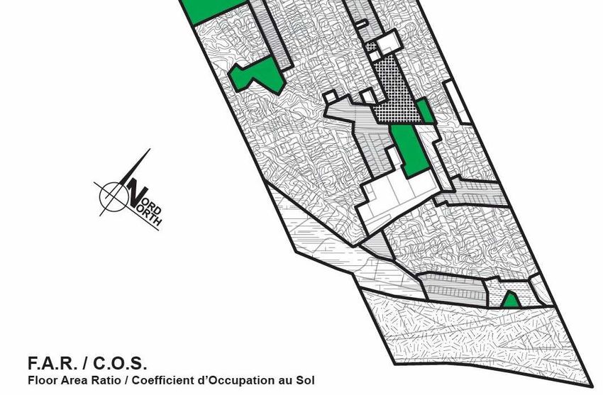
Provisions of the zoning by-law related to setbacks and floor area ratios (F.A.R.) are
modified both to encourage the development potential of the two commercial zones and to
improve the existing streetscape. These changes will result in new construction and
renovation respecting a contiguous building line spanning the entire width of lots.
There will be no change to the permitted maximum building height of 50 feet, or to
minimum rear setbacks of ten feet, anywhere in the town centre (including, for greater
clarity, the east side of Westminster South). Changes in density are shown on the map in
Figure 9 below.
By-law provisions will be enacted specifically to address the concerns of residents of
Ballantyne South that development on Westminster South would reduce their privacy and
sunlight exposure. These provisions will define an oblique plane above which no structure
or obstruction can be erected on that part of Westminster. By trimming back the maximum
permissible heights at the rear of buildings on Westminster South as illustrated in Figure 7,
these provisions will actually be an improvement over the zoning provisions which were
negotiated by the residents of Ballantyne South in 1991.
- 24 -Fig 7. Concept sketch of zoning changes on Westminster South
ACTIONS
3.2.1 Revise the permitted floor-area ratio to minimum 1.5 and maximum 3.0, and
building height to 3 stories plus mezzanines/attics, on the east side of
Westminster South.
3.2.2 Adopt mitigating provisions to improve zoning for privacy and sunlight for
properties to the rear of Westminster South, as illustrated in Figure 7.
3.2.3 Revise the permitted side setbacks on Westminster between Curzon and Avon
from 4.0 feet to zero.
3.2.4 Revise the permitted front setbacks on Westminster South from 15 feet to
minimum 0 feet, maximum 8.0 feet.
- 25 -3.3 IMPLEMENTATION
See section 1.4 for interpreting time frames and cost levels in the following table. Note
that time frames are only approximations.
Objective 3.1—Attract desirable uses
Action Priority Level Cost Time Frame
3.1.1 Redefine permitted uses in
High Low 2009-2010
the downtown core
3.1.2 Redefine permitted uses in
Medium Low 2009-2010
light-industrial zones
Objective 3.2— Harmonize building height, setbacks, density in the Town Center
Action Priority Level Cost Time Frame
3.3.1 Revise density provisions on
Westminster South High Low 2009
3.3.2 Adopt mitigating provisions
High Low 2009
on Westminster South
3.3.3 Revise side setbacks on
Westminster between Avon
High Low 2009
and Curzon
3.3.4 Revise front setbacks on
High Low 2009
Westminster South.
- 26 -Fig 8. New land-use designation map.
- 27 -Fig 9. New density map – Floor-area ratio and building height.
- 28 -Chapter 4
INFRASTRUCTURE RENEWAL
4.1 BACKGROUND
Infrastructure in older parts of Montreal West date from the turn of the 20th century and
newer parts were mostly laid out before 1960. Not surprisingly, the town’s infrastructure is
generally outdated and in poor condition. In the 2007 community-wide survey12 conducted
by the TPC, residents overwhelmingly placed improved streets and sidewalks at the top of
the list of issues requiring municipal attention. Like many communities across Canada,
Montreal West is burdened with crumbling streets and sidewalks, endless water main breaks,
faulty valves and exfiltrating sewers. Deteriorating road and subsurface conditions add up to
ever increasing maintenance and repair costs, danger for vehicular and pedestrian movement,
and water and sewer headaches for homeowners. Accordingly, infrastructure renewal will
remain the top priority until the problems are corrected.
4.2 PLANNING OBJECTIVE
Improve the town’s physical infrastructure
Since January 2006, the municipality has undertaken a number of actions to address this
issue. The town has repaired the northern bridge, relined water mains, installed new valves
and hydrants and made major repairs to streets, sidewalks and subsurface services. This long-
term infrastructure repair plan is based on priorities established in engineering studies
prepared by the consulting firm Genivar.13 The studies and the town’s three-year repair plan
were presented to the public at information meetings in July 2007 and May 2008.
ACTIONS
4.1.1 Complete the detailed plans for years 2 and 3 of the infrastructure renewal
plan.
12 See footnote 7.
13 These studies are available at Town Hall for consultation.
- 29 -4.1.2 Obtain provincial and other funding and complete the reconstruction of
outdated sewers, aqueducts, streets and sidewalks under the plan.
4.3 IMPLEMENTATION
See section 1.4 for interpreting time frames and cost levels in the following table. Note
that time frames are only approximations.
Objective - Improve the town’s municipal infrastructure
Action Priority Level Cost Time Frame
4.1.1 Continue replacement of
High High Ongoing
aged infrastructure
4.1.2 Obtain funding from
High Low Ongoing
province and other sources
- 30 -Chapter 5
TRANSPORTATION AND TRAFFIC
MANAGEMENT
5.1 BACKGROUND
Since the Grand Trunk Railway tracks were laid in 1855 and the CPR tracks in 1886, railways
have played an important role in the growth and development of the town, providing quick
and direct access to Montreal’s downtown core. The Agence métropolitaine de transport
(AMT) station, located just east of Montreal West’s town limits, was built in 1905 by the
CPR. Today, three commuter rail lines provide train service between downtown and
suburbs in the northern, western and southern parts of the Greater Montreal Area.
Montreal West is well served by public transit. Most homes are located within a ten-minute
walk of public transportation. Residents have direct access to two bus routes (90 and 162)
and four additional routes on the town’s borders (51, 103, 105 and 123). Three commuter
train lines pass through Montreal West: Dorion-Rigaud, Blainville-Saint-Jerome, and Delson-
Candiac. A total of 43 trains stop at the Montreal West Station on weekdays. Train volumes
will increase considerably if the proposed airport shuttle uses this corridor although the
effect on the town will be minimized once the tracks are buried.14
Several features of the transportation configuration are hazardous, especially for pedestrians.
First, the town’s main north-south route experiences major traffic hold-ups at the level
crossing at Westminster and Sherbrooke Streets (Figure 10) during rush hours due to passing
trains and ineffective traffic management. Traffic management at the level crossing is
complicated for both vehicles and pedestrians by significant east-west vehicular volumes
converging onto Westminster from Sherbrooke just north of the tracks and from Broughton
just to the south. Traffic is currently managed with stop signs (and a policeman during
morning rush hour) because the frequent but irregular train activity makes the use of traffic
lights very difficult and expensive. This is not optimal, as the signs at Broughton and
14It is not known at this time whether this or the CN right of way just south of the Town will be chosen for
the shuttle.
- 31 -Sherbrooke are located far apart and on either side of the tracks, effectively enclosing them
in a four-way stop. As a result, crossing is quite difficult for pedestrians and a nightmare for
drivers, especially those trying to turn left from Sherbrooke onto Westminster and left from
Westminster onto Sherbrooke. According to a study prepared for the City of Montreal,15,this
stretch of Westminster between Sherbrooke and Avon is the part of the circulation network
requiring the most attention.
The second hazardous situation is the series of four-way stops along Westminster from
Parkside to Curzon, which are not sufficiently safe for pedestrians because drivers often
don’t stop at the signs and travel over the speed limit.
Fig. 10. Level crossing at Westminster and Sherbrooke, looking north over the tracks.
Third, Montreal West’s central location results in a significant amount of vehicular traffic
passing north and south through the municipality, often generating unacceptable traffic
speeds and volumes on local streets (see Figure 11 for a street hierarchy map). Streets that
15
CIMA, Traffic Impact Study—Westminster Avenue between Sherbrooke and Avon, 2003.
- 32 -were designed to be local have become, in some cases, major collectors as drivers use them
to avoid congestion on Westminster, and in other cases as a short cut to Highway 20.
Fig. 11. Street hierarchy in Montreal West.
- 33 -5.2 PLANNING OBJECTIVES
OBJECTIVE 1 – Improve the management of vehicular traffic
The town has identified five priority areas for improved traffic management: 1) the
intersection at the level train crossing, 2) the five-way stop at Westminster and Avon; 3) the
unacceptably high volume and speed of through traffic on some local streets; 4) traffic safety
in school drop-off zones; and 5) the configuration of the intersection of Ronald Drive and
Brock South as the rebuilding of Highway 20 proceeds.
The best solution to the dangerous and congested vehicular and pedestrian traffic conditions
at the level crossing would be to bury all the tracks. In the event that the airport shuttle
comes through town, this is exactly what has been announced. This would improve
pedestrian connectivity between Westminster North and South thereby unifying the town
centre.
Pedestrian safety at the five-way intersection of Avon and Westminster must be improved.
One solution to be investigated in detail is a traffic circle, in light of traffic patterns as they
currently exist and as they may evolve in response to the other changes proposed for
Westminster South.
ACTIONS
5.1.1 a) Continue to work with the AMT, CPR, Transport Quebec and Transport
Canada to provide a pedestrian subway from Broughton to Sherbrooke, to
improve traffic management at the level crossing through increased police
presence, and to eliminate the northernmost track; and
b) Ensure that if the airport shuttle comes through town, all of the tracks are
buried as promised, and that the right-of-way is developed as mixed green
space and light commercial.
5.1.2 Improve pedestrian safety and traffic circulation at Westminster and Avon.
5.1.3 Prepare and implement a traffic calming plan for local north-south streets (see
Chapter 6 for details).
- 34 -5.1.4 Ensure that Brock South does not become an access route to and from
Highway 20, and reconfigure the corner with Ronald Drive to improve visuals
and liveability.
OBJECTIVE 2 – Create pleasant, safe and efficient pedestrian links
between the various points of interest in town
The safe movement of pedestrians, especially children, and cyclists is vital to the quality of
life in a community. Accordingly, this Urban Planning Programme gives priority to
pedestrians and resident safety over vehicular convenience. Almost all of the town’s
institutional and recreational facilities such as schools, libraries, parks, the arena, playing
fields and the Town Hall are located west of Westminster, which is the town’s main north-
south artery as well as its commercial street, while much of the population lives to the east of
it. The street network’s current design and traffic management system have produced an
array of traffic problems including congestion at peak hours, unsafe intersections and
crosswalks, and speeding. Furthermore, existing paths between the train station and Royal
West Academy and the north side of the tracks could be further improved in terms of safety
and visual integration, such as by installing a pedestrian subway.
ACTIONS
5.2.1 Prepare and implement a pedestrian and bicycle movement plan.
5.2.2 Install clearly demarcated and raised crosswalks along Westminster at
Parkside, Nelson, Curzon, Milner, Sherbrooke, Broughton and Avon.
5.2.3 Clearly mark and enforce parking prohibitions within three meters of
intersections in order to improve visibility.
5.2.4 Create safe bicycle corridors and connect local bicycle routes to the wider
Montreal Island bicycle network.
5.2.5 Improve snow and ice removal from all sidewalks as a safety and senior-
friendly initiative.
- 35 -OBJECTIVE 3 – Improve and expand parking in the town centre
In the town’s main commercial area along Westminster between Sherbrooke and Curzon
there are approximately 65 parking spaces which are available at no charge both on the street
and in municipal parking lots. An expanded and revitalized town centre (see Chapter 3)
would require additional parking accessible to businesses and residents. Doubling parking
spaces in the immediate vicinity of the town centre, to a total number of 130 spaces, would
greatly improve the viability and vitality of businesses on Westminster Avenue.
ACTIONS
5.3.1 Modify zoning by-laws to ensure adequate parking requirements for new
construction, including underground parking spaces where necessary.
5.3.2 Maximize capacity in existing parking lots.
5.3.3 Create new parking lots where possible, including possible arrangements
with the CPR.
5.3.4 Incorporate underground parking in new Community Recreation Complex, if
feasible.
5.3.5 Improve parking turnover in commercial zones by controlling parking times
during business hours.
5.3 IMPLEMENTATION
See section 1.4 for interpreting time frames and cost levels in the following table. Note
that time frames are only approximations.
Objective 5.1 - Improve Management of Vehicular Traffic
Action Priority Level Cost Time Frame
5.1.1 Improve traffic management
High various Ongoing
at level crossing
5.1.2 Improve traffic management
Medium High Ongoing
at Westminster and Avon
5.1.3 Implement Traffic Calming
High Medium 2009-2011
Plan
5.1.4 Ensure that no additional
access is provided via Brock
High Low Ongoing
Avenue
- 36 -Objective 5.2 – Create Pleasant, Safe and Efficient Pedestrian Links
Action Priority Level Cost Time Frame
5.2.1 Prepare and implement plan High Medium 2010-2013
5.2.2 Install raised crosswalks High Medium 2010
5.2.3 Mark and enforce no parking
High Low Ongoing
distances from corners
5.2.4 Create safe bicycle routes and
High Medium 2009-2010
connect to Montreal network
5.2.5 Improve sidewalk snow and
High Low Ongoing
ice removal
Objective 5.3 - Improve and Expand Parking
Action Priority Level Cost Time Frame
5.3.1 Modify parking requirements
Medium Low 2009
for new construction
5.3.2 Improve existing lots High Medium 2010-2013
5.3.3 Create new parking spaces
Medium High 2010-2013
5.3.4 Include underground parking
Medium High On construction
in Recreation Complex
5.3.5 Improve parking turnover on
Medium Low 2010-2012
Westminster
- 37 -Chapter 6
NEIGHBOURHOOD LIFE
6.1 BACKGROUND
Montreal West is prized for its beautiful quiet residential areas and neighbourhood quality of
life. When surveyed, residents rated heritage architecture and greenery along with
neighbourliness and community spirit among the features they value most about their town.
The grid layout of older neighbourhoods recalls the town’s early history as a streetcar suburb
when most people walked or used public transport to get around. The street pattern in these
areas is designed using Westminster as the major north-south collector, fed by minor east-
west collectors (Nelson, Curzon, Parkside, Ainslie, Broughton) giving onto local streets
which are intended for resident use (see Figure 11). Newer neighbourhoods make use of
loops and cul-de sacs to limit through traffic and keep streets quiet and safe.
6.2 PLANNING OBJECTIVES
OBJECTIVE 1 – Make residential areas safer and quieter
Long north-south avenues such as Brock North, Ballantyne North and Strathearn North
have come to serve as thoroughfares for motorists wanting to bypass traffic on Westminster
Avenue, and traffic safety has therefore become a major concern for residents on these
streets. The Town’s standing Traffic and Safety Committee (TSC) has long addressed general
traffic issues, and in early 2008 a subcommittee of the TSC and the TPC, the “Streets
Committee”, was formed to address mounting concerns about increasing traffic volume and
dangerous driving on some local streets, especially on the three streets noted above.
Unacceptably high traffic volumes and speeds on these streets undermine their residential
nature and threaten the safety of pedestrians, children and cyclists. High traffic volumes and
speeds also create noise pollution, undermining municipal efforts to reduce ambient noise in
residential areas.
Following public consultation with residents, the Streets Committee prepared a traffic
calming plan which was endorsed by traffic engineers at Genivar, whose objectives are to:
- 38 -• Make residential streets safe for pedestrians, cyclists and children;
• Improve neighbourhood environments;
• Ensure residents’ accessibility to their homes;
• Ensure pedestrian and cyclist connectivity to Westminster, public transportation,
schools, parks and recreational facilities, especially on the east-west axis; and
• Implement these initiatives while improving safety on Westminster as set out in
Chapter 5, in order to preserve the quality of life of residents on Westminster.
The traffic calming plan is designed to prevent the use of Brock North, Ballantyne North
and Strathearn North as bypass roads, and to ensure that residents on these streets will
continue to have good accessibility. To discourage speeding and through traffic on local
roads, the Town is considering the implementation of a number of measures, including the
reintroduction of two-way streets and the introduction of physical interventions such as
neck-downs, speed humps, signage, and chicanes, allowing residents to reclaim their streets
and create a safer and more tranquil environment. These measures will be combined with
more effective vehicular traffic control on Westminster through improved intersection and
crosswalk design, the introduction of chicanes at intersections to improve access to homes,
and the realization of lower traffic volumes through better access eastward off Westminster.
ACTIONS
6.1.1 Conduct before and after studies of traffic volumes and speeds on affected
streets.
6.1.2 Carry out traffic calming pilot projects.
6.1.3 Install traffic calming devices where appropriate.
OBJECTIVE 2 – Encourage property maintenance and renovation
The Town adopted a Site Planning and Architectural Integration Programme (SPAIP) By-
law in 1995, covering the totality of its territory. The SPAIP By-law will be reviewed by both
the TPC and the Planning Advisory Committee from time to time in order to refine its
objectives and to ensure that the neighbourhoods in question preserve their historical
character. Given the architectural quality of Montreal West’s older neighbourhoods,
- 39 -You can also read