Workshop Report on Nexrad-In-Space - A Geostationary Satellite Doppler Weather Radar for Hurricane Studies
←
→
Page content transcription
If your browser does not render page correctly, please read the page content below

Workshop Report on Nexrad-In-Space – A Geostationary Satellite Doppler Weather
                         Radar for Hurricane Studies
                        Simone Tanelli, Eastwood Im, Eric A. Smith, V. Chandra Chandrasekar,
                                  Frank Marks, Gregory Tripoli, and Shuyi Chen
     Abstract – NEXRAD-In-Space (NIS) is a mission concept to             considerations require a large domain. The vortex response to
provide a geostationary satellite Doppler radar. It was developed         the environmental forcing ultimately involves convection on
over the last 4 years under the auspices of NASA’s Earth Science          small horizontal scales in the eyewall and rainband regions.
Instrument Incubator Program (IIP). The NIS would provide                 Resolving this environment-vortex-convection feedback in a
Ka-band (35 GHz) reflectivity and line-of-sight Doppler velocity          numerical model requires observations on the space and time
profiles over a circular Earth region of approximately 5200 km in         scales necessary to unambiguously define these structures
diameter with a 12-km horizontal resolution, and a minimum                within and surrounding the tropical cyclone. Because the time
detectable signal of 5 dBZ. The NIS radar achieves its superb             and space scales of these processes are small, continuous 3-
sampling capabilities by use of a 35-m diameter, deployable               dimensional independent observations of the 3-dimensional
antenna made from lightweight membrane material.              The         wind and precipitation structures will be needed to initialize
antenna has two transmit-receive array pairs that create a dual-          numerical models critical for this purpose. The proposed NIS
beam, spiral-feed combined profile image of both reflectivity and         Doppler radar would be the first instrument capable of
Doppler velocity approximately every 60 minutes. This sampling            accomplishing this feat at time scales less than hours, and
time can be shortened even further by increasing the number of            would create the opportunity for hurricane science to enter a
transmit-receive array pairs.                                             new era of understanding and improved prediction. Thus, the
                                                                          scientific thrust of the Workshop was to develop the scientific
                         I. INTRODUCTION                                  framework for exploiting the NIS radar data through
                                                                          continuous 3-dimensional data assimilation of the Doppler and
     The NEXRAD-In-Space (NIS) Science and Technology                     reflectivity signals in non-hydrostatic cloud resolving models.
Road Map Workshop was held on 10-11 April 2007. NIS is a
mission concept to provide a geostationary satellite Doppler                   This paper presents         the key     findings and
radar. It was developed over the last 4 years under the                   recommendations from the NIS Workshop, including brief
auspices of NASA’s Earth Science Instrument Incubator                     summaries of the instrument concept, the current technology
Program (IIP). The NIS would provide Ka-band (35 GHz)                     status, the anticipated impacts on hurricane monitoring and
reflectivity and line-of-sight Doppler velocity profiles over a           model prediction, and the future science and technology
circular Earth region of approximately 5200 km in diameter                roadmap.
with a 12-km horizontal resolution, and a minimum detectable
signal of 5 dBZ. The NIS radar achieves its superb sampling                   II. DISASTROUS 2004 AND 2005 HURRICANE SEASONS
capabilities by use of a 35-m diameter, deployable antenna
made from lightweight membrane material. The antenna has                       The 2004 and 2005 hurricane seasons led to
two transmit-receive array pairs that create a dual-beam,                 unprecedented death, damage, and suffering within the Gulf
spiral-feed combined profile image of both reflectivity and               Coast and Florida region, particularly due to Hurricane
Doppler velocity approximately every 60 minutes. This                     Katrina (Figure 1) which flooded over 80% of the City of
sampling time can be shortened even further by increasing the             New Orleans, destroyed entire sections of the city, and
number of transmit-receive array pairs.                                   destroyed or incapacitated major infrastructure elements of the
                                                                          U.S. energy system. In addition to some 2,000 fatalities in
    It is generally recognized that the processes important in            Alabama, Mississippi, and Louisiana, and the wholesale
governing hurricane intensity and structure span a wide range             destruction of over 350,000 homes and businesses, Hurricane
of spatial and temporal scales. The environmental forcing                 Katrina (along with Hurricane Rita) destroyed many of the
  _________________________________________________________
                                                                          Gulf’s stationary and mobile oil platforms, i.e., some 150
                                                                          facilities responsible for approximately 15% of America’s
   Simone Tanelli and Eastwood Im are with the Jet Propulsion             petroleum supply.
Laboratory, California Institute of Technology, Pasadena, California
91109 (e-mail: eastwood.im@jpl.nasa.gov).
   Eric A. Smith is with NASA Goddard Space Flight Center, Greenbelt,
                                                                               These two recent hurricane seasons have spurred hyper
Maryland 20771.                                                           research activity into the scientific cause(s) of such destructive
   V. Chandra Chandrasekar is with Colorado State University, Fort        sequences of storms and the possibility that the Earth has
Collins, Colorado 80523-1373.                                             evolved a climate in which this type of hurricane season
   Frank Marks is with NOAA Hurricane Research Division, Miami,           represents the norm rather than the exception. This debate is
Florida 33149.
   Gregory Tripoli is with University of Wisconsin, Madison, Wisconsin    complicated by the fact that there are decadal and longer
53706.                                                                    oscillations in climatic processes that can affect hurricane
   Shuyi Chen is with University of Miami, Coral Gables, Florida 33124.   frequency, track preference, and intensity, variations that are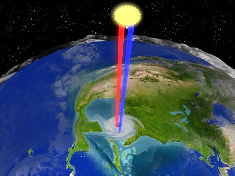
superimposed over an almost certain global warming trend, all          Forecasting, September 2006 [5]), and the National Science
of which is strongly influenced by uncertain changes in ocean          and Technology Council (NIST – Windstorm Impact
temperatures. Accordingly, the debate has intensified in the           Reduction Implementation Plan, April 2006 [6]) released
same fashion as the recent hurricanes.                                 white papers on the research needed to address hurricanes and
                                                                       their impact. Such government reassessments identify what
                                                                       types of civic and forecasting strategies are needed to cope
                                                                       with tropical storms and hurricanes that impact not only
                                                                       Florida and the Gulf Coast region, but also the entire eastern
                                                                       seaboard – which, as Hurricane Isabel demonstrated during
                                                                       2003 (see Figure 2), can experience severe damage and
                                                                       widespread fatalities well north of the southeastern high
                                                                       impact region.

 Figure 1: Montage created from sequence of Hurricane Katrina
 infrared satellite images obtained from NOAA’s Geostationary
 Operational Environmental Satellite (GOES) showing advance of storm
 into vicinity of New Orleans over 23-29 August 2005. [Courtesy of
 Christopher Velden at NOAA/Cooperative Institute for Meteorological
 Satellite Studies (CIMSS) at Univ. of Wisconsin.]

 III. IMPORTANCE OF I MPROVING HURRICANE FORECASTING –
                  ESPECIALLY INTENSITY                                    Figure 2: Track of Hurricane Isabel (category 5 hurricane) into
                                                                          northeastern U.S. during September 2003. [Courtesy of
     The frequency and ferocity of major storms making                    NOAA/CIMSS at Univ. of Wisconsin.]
landfall during the 2004-05 hurricane seasons, and the                      A major element of these reassessments has involved
possibility that such seasons are now an expected element of           seeking means to improve hurricane intensity and structure
the global climate, have exposed a number of vulnerabilities
                                                                       forecasting. It is well recognized that in order to improve
within federal, state, and local organizations charged with the
                                                                       responsiveness to hurricane related hazards, it is essential to
responsibility for civil protection, hazard forecasting, and
emergency management pertaining to hurricanes. As a result,            reduce the uncertainties in the hurricane model forecasts, and
the National Oceanic and Atmospheric Administration                    to improve the ability to forecast the expected impact of
(NOAA) Science Advisory Board established a Hurricane                  hurricanes using sophisticated models that base their outlooks
Intensity Working Group (HIRWG), to review NOAA’s                      directly on the hurricane forecasts themselves. Outside of the
efforts to improve hurricane intensity prediction [1]. At the          forecasting community, it is generally not appreciated that,
same time, the National Science Foundation’s National                  whereas hurricane track forecasting has experienced steady
Science Board (NSF-NSB) established a working group to                 improvement over the last three decades, over this same
examine the national needs for research into hurricanes                period, the forecast of hurricane intensity and structure has
covering all aspects of the problem, from forecasts to                 realized almost no meaningful improvement (see Figure 3). In
mitigation [2]. These reports supplement the series of                 effect, using an analogy, computer models are only having
planning documents developed by the federal and academic               verifiable success forecasting hurricanes as “corks floating in
communities under the auspices of the Office of the Federal            streams”, while experiencing almost no success in forecasting
Coordinator for Meteorology (OFCM) and the U.S. Weather                how the sizes and shapes of the corks evolve.
Research Program (USWRP), e.g., “www.ofcm.gov/tcr/tcr-
index.htm”. In addition, OFCM just issued the latest federal                In fact, it is now recognized that operational hurricane
plan for hurricane research (“www.ofcm.gov/p36-isrtc/fcm-              forecast models have only improved in their ability to trace
p36.htm”) [3], while the American Geophysical Union (AGU               the path that hurricanes will follow as they move downwind,
- Hurricanes and the U.S. Gulf Coast: Science and Sustainable          while their ability to predict the speeds at which they move
Rebuilding, June 2006 [4]), the American Meteorology                   along their trajectories have not improved substantially. This
Society (AMS – AMS Statement on Hurricane Research and                 helps understand why NOAA, NSF, AGU, and NIST have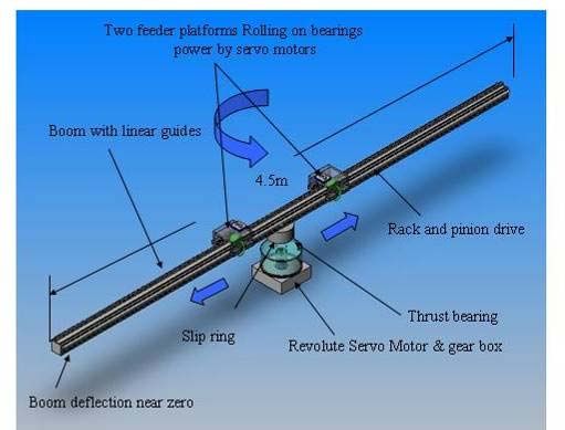
gone on record with planning strategies needed to revise how         hundred kilometers around the developed world. The spacing
hurricane predictions are carried out and which factors              and frequency of these observations are usually sufficient to
involving hurricane forecasting deserve the most attention. It       define the energy processes involved in cold and warm air
also explains why various new hurricane prediction program           mixing that occur on scales of hundreds to thousands of
initiatives focusing on accuracy improvement and forecast            kilometers and over periods of several days. Alternatively,
timeliness, such as the Hurricane Intensity Forecast                 energy released in cumulus clouds is the driving force for
Improvements (HiFi) project (“www.nova.edu/ocean/hifi/               hurricanes, for which the relevant cloud systems occur on
index.html”), are now underway.                                      space scales of just tens of kilometers and time scales of just
                                                                     minutes. In effect, these features entirely fall between the
                                                                     conventional radiosonde observations that are sufficient to
                                                                     define and predict the frontal cyclones. Moreover, hurricanes
                                                                     evolve over the oceans, where even conventional observations
                                                                     are sparse. To define the state of these energy-generating
                                                                     processes, equivalent to the way energy-producing processes
                                                                     are observed for frontal cyclones, will require observations
                                                                     with the grid spacing of a few kilometers and the sampling
                                                                     frequency of a few minutes.

                                                                          The problem is further complicated by the fact that
                                                                     operational computer prediction models have traditionally
                                                                     been limited to predicting storm scale circulations while
                                                                     representing the smaller scale flows as somehow being driven
                                                                     in a prescribed fashion by the ambient storm scales
                                                                     themselves. However, when the energy originates on the small
                                                                     scales and then wells up to drive the storm scales, as with
                                                                     tropical cyclones, traditional models utterly fail in a
                                                                     fundamental way. We call convectively-driven storms such as
                                                                     hurricanes “ bottom up” systems since the energy comes from
                                                                     the small scales to drive the large scales, whereas frontal
                                                                     cyclones are “top down” systems since they derive their
                                                                     energy from thermal contrasts on scales at least as large as the
                                                                     storms themselves. It is thus clear that if verifiable hurricane
                                                                     intensity forecasting is to become a reality, the 20th century
                                                                     observation and weather model prediction paradigm must
                                                                     change. The change is made possible by converting the
                                                                     computer models to what are called cloud-resolving models
                                                                     (CRMs) which are able to represent the very small scale cloud
                                                                     processes, and by converting the observational technologies to
                                                                     continuously-monitoring, very high spatiotemporal resolution
    Figure 3: National Hurricane Center predictions demonstrating    space-based radar remote sensing technologies. Most notably,
    gradual improvement in track forecasting over 1990-2004 period   the computer model and space technologies needed for such a
    (upper panel) while at same time demonstrating almost no
    meaningful improvement in intensity forecasting (lower panel).
                                                                     transformation are now available.
    (See “www.nhc.noaa.gov/verification/verify5.shtml”.)
                                                                          V. POTENTIAL FOR DOPPLER RADAR MONITORING OF
                                                                                     HURRICANES FROM SPACE
IV. UPGRADING N UMERICAL PREDICTION OF HURRICANES TO
                 CRM-BASED MODELS                                         There are only a few instrument systems that can be used
                                                                     for measuring the behavior of tropical storms and hurricanes
     To understand why improvements in predicting the                for the purpose of hurricane monitoring and prediction
evolution of hurricane structure and intensity have lagged           through data assimilation. Of these, only the U.S. Weather
behind the ability to predict another classical storm event, the     Service’s network of NEXRAD coastal ground Doppler
mid-latitude frontal cyclone, it must be recognized that there       radars, NOAA’s airborne Doppler radars on the NOAA WP-
are fundamental differences in where and how these two types         3D and G-IV aircraft, and the optical-infrared imaging
of storms derive their energy. Frontal cyclones, responsible         radiometers on NOAA/National Environmental Satellite Data
for the rain and snow storms most common over North                  Information Service’s (NESDIS) geostationary Earth-orbiting
America, derive their energy from the contrasts of temperature       (GEO) operational GOES satellites are capable of
between tropical and polar latitudes. These contrasts are            continuously monitoring the position and appearance of
readily observed and quantified by balloon-borne observations        hurricanes.
(radiosondes) taken twice daily at a spacing of several
improvements in hurricane track forecasting. In fact, to date,
It is well recognized that optical-infrared instruments on the National Centers for Environmental Prediction (NCEP),
the operational GEO satellites can only observe cloud tops the U.S. National Weather Service’s primary numerical
(refer to Fig. 1 above) – not the internal dynamics, vertical weather prediction unit, has been unable to achieve any
structure, and intensity of hurricanes. While the airborne meaningful improvement in hurricane forecast accuracy
Doppler radars fly out to collect data when the storms are out through assimilation of TRMM data into their operational
to sea, they are limited in temporal sampling to only one or forecast models. The main reason for this is that the TRMM
two missions a day. Whereas the continuously-probing satellite was designed for the collection of a multi-year
NEXRAD Doppler ground radars are very useful for climatology of rainfall in the tropics, not for monitoring
monitoring storm behavior, since at radar frequencies the hurricanes at the needed hourly-type sampling frequency, and
internal structure of a storm can be observed and thus 4- with the required information on internal dynamics that only a
dimensional views of storm dynamics and hydrology are Doppler radar can provide.
achievable, there are limitations with ground radars associated
with their range limitations, and the beam spreading – VII. ADVANTAGES OF NIS-TYPE SATELLITE FOR HURRICANE
overshoot effects away from the radar beam source. There are OBSERVING AND FORECASTING
also endemic problems with keeping the network of
NEXRAD radars calibrated to a standard secondary A space-based Doppler radar system on a GEO satellite
calibration reference. platform would bring about a paradigm shift in the prediction
of hurricanes because such a system could provide the three
These are the main reasons why continuously-profiling most urgently needed measuring capabilities for making
Doppler radars located on geostationary satellite platforms hurricane intensity predictions. First, a GEO measuring
would offer a more effective measuring capability. In fact, platform could produce the required sampling frequency over
Doppler radar profiling from above a storm is superior to side- the required space-time domain. Second, a space-based
view profiling since, because hurricanes are shorter than they Doppler radar system could provide the triad of foremost
are wide, they reveal more of their internal structure when measurements of a hurricane’s strength, i.e., its vertical
viewed from above. Moreover, GEO satellites can follow profiles of vertical velocity, precipitation intensity, and rate of
hurricanes throughout their entire lifetime – unlike NEXRAD atmospheric heating through the release of latent heat of
radars for which the range limits, fixed viewing domains, and condensation. Third, a space-based data stream would enable
the inability to see hurricanes out to sea fracture the observing continuous 4-dimensional data assimilation of these
process over key portions of hurricane life cycles. fundamental hurricane parameters into operational forecasts
Nonetheless, despite the great success of ground Doppler generated by very high-resolution cloud-resolving models
weather radars in monitoring local weather and tracking (CRMs). All three of these capabilities are essential for greatly
landfalling hurricanes, and although the technology required improved hurricane forecasts. These considerations led to the
to make Doppler weather radar measurements from space was NEXRAD-In-Space (NIS) satellite design concept [7].
developed over a decade ago by the National Aeronautics and
Space Administration (NASA), this technology has yet to be VIII. DESIGN FRAMEWORK FOR NIS’S GEO DOPPLER RADAR
exploited by NASA or NOAA on an Earth-observing SYSTEM
spacecraft.
In the following, a brief description of the 35-GHz NIS
VI. DISADVANTAGES OF TRMM SATELLITE FOR HURRICANE radar technology concept designed for greatly improved
OBSERVING AND FORECASTING hurricane observing and forecasting is provided. It is
necessary to understand that a GEO satellite platform used for
Notably, NASA first launched a satellite designed for the flying the radar is the only type of platform that can ultimately
direct measurement of precipitation from space in November provide the required time sampling (notionally a 1-hour
1997 – i.e., the Tropical Rainfall Measuring Mission (TRMM) sampling frequency), the required spatial integrity and
– a low Earth orbiting (LEO) satellite platform which is still cohesiveness, and the overall required Doppler capability – in
making measurements from 400 km above the Earth out to the a cost-effective package. It is also important to recognize that
35 degree latitude parallels. However, the rain-measuring the radar antenna for the NIS GEO platform is very large
instruments developed for this mission, which include a Ku- (~35-meter diameter) using lightweight, deployable space-
band (14 GHz), cross-nadir-scanning precipitation radar and a qualified material such as Shape Memory Polymer (SMP) that
9-channel, conical-scanning, passive microwave radiometer, will require approximately a decade of lead time for
only observe a given point within the tropical-subtropical development. A 35-meter diameter antenna is about 1/3 the
latitudes some 25-28 times per month. The radar itself does size of a football field. This size requirement stems from the
not include Doppler measuring capability and thus does not fact that the GEO satellite orbit must be about 35,270 km –
measure the internal dynamics and intensities of tropical approximately 100 times that of the LEO orbiting TRMM
cyclones. Data collected by the TRMM satellite have led to satellite – and thus the antenna must be large for the radar to
some success in improving hurricane forecasts through data achieve meaningful horizontal resolution for hurricane
assimilation, but the success has been limited to minor observations. Notably, Japan Aerospace Exploration Agency(JAXA) recently launched a geostationary communications
satellite that uses two 17 x 19 meter size lightweight
deployable antennas, each about the size of a tennis court.
[See “www.jaxa.jp/ countdown/f11/outline/index_e.html”.]
The NIS radar concept consists of a Ka-band (35 GHz)
radar with Doppler acuity and optional polarimetric diversity.
Because a GEO satellite is a quasi-stationary platform, some
limited Doppler spectrum width information is also
obtainable. The NIS antenna design consists of a deployable,
inflated spherical reflector (Figure 4) with two radially
opposed Doppler radar feed array pairs (one each for transmit
and receive) situated in carriages which slide mechanically
along a rotating arm below the antenna (Figure 5), thus
producing a spiral scan pattern over a 48-degree great circle
arc once every hour. The antenna size provides for ~12 km
spatial resolution at nadir (Figure 6). The entire radar system Figure 6: Artistic rendition of GEO-NIS radar viewing Hurricane
can also be pointed (articulated) to the preferred domain of the Katrina (28 August 2005).
Earth-atmosphere containing a target hurricane.
The main technology development elements required to
realize the GEO radar system are related to the large inflatable
antenna, including lightweight flexible materials and the
deployable structure, the ability to determine the shape of the
antenna surface to the required accuracy (thus the current
preference for SMP), and the ability to actively correct any
antenna shape distortions while in flight with different types
of actuator systems. Without correction, antenna shape
distortions would arise because of stresses due to thermal
gradients developing on the antenna due to variable solar
heating across the antenna surface.
Looking beyond the current conceptual design, it is
anticipated that NIS could be further refined by increasing the
time sampling down to approximately 15 minutes and the
spatial resolution down to approximately 5 km. Sampling
improvement and some spatial resolution improvement could
Figure 4: Schematic of fully deployed GEO-NIS satellite viewing be achieved by modifying the design of the mechanically
Earth with two spiraling Doppler radar feeds. Insets show 30-meter rotating arm and by including intelligent variable control of
radar antenna in three different stages of deployment. the feed motions drives, which could produce repeat sampling
and thus spatial resolution enhancement through a
deconvolution operator.
Additional spatial resolution could be obtained by making
NIS a W-band (94 GHz) frequency radar. Another exciting
path for improvement would be to develop NIS as a dual-
frequency 35/94-GHz radar system, which through differential
reflectivity algorithm schemes would enable measurements of
hydrometeor drop-size distribution (DSD) and additional
microphysical details within the hurricane environment. These
are all technology improvement issues that go beyond the
technologies that have been studied or tested for the current
NIS design prototype, but nonetheless are improvements that
lie well within reach of the NIS design concept.
IX. CONCLUDING REMARKS
Figure 5: Schematic of rotating arm for affixing to top of
satellite below large spherical antenna in which arm This report describes satellite radar technology and
includes two carriages each containing a transmit/receive hurricane modeling paths for improving hurricane observing
feed array pair where combined sliding carriage motions and forecasting in the course of the next decade. The
generate two contiguous spiral trajectories.observing capability stems from the use of a Ka-band (35 ACKNOWLEDGMENT
GHz) Doppler weather radar system on-board a geostationary
satellite platform (i.e., the NIS satellite), which would produce The authors would like to acknowledge the support
hourly observations of a hurricane’s position, intensity, provided by the Earth Science Technology Office (ESTO) and
structure, and internal dynamics. The forecasting the Precipitation Science Program of the National Aeronautics
improvements would arise directly from this revolutionary and Space Administration (NASA).
observing capability by application of continuous data
assimilation into very high resolution cloud resolving forecast
models designed to exploit the three new major measuring REFERENCES
capabilities that the GEO Doppler radar system would
provide: (1) vertical/horizontal velocity, (2) precipitation [1] National Oceanic and Atmospheric Administration Science Advisory
intensity, and (3) rate of atmospheric heating through release Board: Hurricane Intensity Research Working Group Majority Report,
of latent heat of condensation. All of these physical processes October 2006.
would be captured in the level 1 profile measurements of [2] “Hurricane Warning: The Critical Need for a National Hurricane
reflectivity, line-of-sight Doppler velocity, Doppler spectrum Research Initiative,” National Science Board, National Science
width, and optionally co-/cross-polarization amplitudes. Foundation, January 2007.
[3] “Interagency Strategic Research Plan: The Way Ahead,” Office of
This space technology, along with an upgraded numerical the Federal Coordinator for Meteorology, FCM-P36-2007, February
modeling approach involving CRM-based data assimilation, 2007.
represents a complete paradigm shift insofar as observing and [4] “Hurricanes and the U.S. Gulf Coast: Science and Sustainable
forecasting hurricanes in a 4-dimensionl framework. The Rebuilding,” American Geophysical Union Report, June 2006.
outcome of proceeding with this strategy would be a greater [5] “Hurricane Forecasting in the United States: An Information Statement
understanding of hurricane behavior and greater accuracies in of the American Meteorological Society,” American Meteorological
hurricane forecasts – especially the formidable properties of Society, September 2006.
intensity, precipitation production, and flood potential. [6] “National Science and Technology Council Report: Windstorm Impact
Ultimately, this strategy would lead to an improved disaster Reduction Implementation Plan,” National Science and Technology
warning and civil defense system for the U.S. population Council, April 2006.
vulnerable to the destructiveness of intense, landfalling [7] E. Im, S.L. Durden, Y. Rahmat-Samii, H. Fang, V. Cable, M. Lou, and
hurricanes such as highlighted in Figure 7, illustrating the J. Huang, “Advanced geostationary radar for hurricane monitoring
American southeast during August and September 2004 being and studies,” Proc. of 2004 IEEE Radar Conference, pp. 307-311,
pounded unmercifully by one destructive storm after another. 2004.
Figure 7: During 2004 Hurricane Season, the state of Florida experienced
barrage of intense and destructive hurricanes from which it has yet to
recover in terms of destroyed property and displaced people. [Courtesy
of Mr. Christopher Velden at NOAA/CIMSS at Univ. of Wisconsin.]You can also read