19 Centrepointe Drive - Planning Rationale Site Plan Control Application May 14, 2021 - City of Ottawa
←
→
Page content transcription
If your browser does not render page correctly, please read the page content below
19 Centrepointe Drive
Planning Rationale
Site Plan Control Application
May 14, 2021

Prepared for Richcraft Homes

Prepared by Fotenn Planning + Design
396 Cooper Street, Suite 300
Ottawa, ON K2P 2H7

May 2021

© Fotenn
The information contained in this document produced by Fotenn is solely for
the use of the Client identified above for the purpose for which it has been
prepared and Fotenn undertakes no duty to or accepts any responsibility to
any third party who may rely upon this document.

1.0 Introduction                                                           1
     1.1      Subject Site                                                 1
     1.2      Application Summary                                          1
     1.3      Application History                                          2
     1.4      Area Context                                                 2
     1.5      Road Network                                                 6
     1.6      Rapid Transit Network                                        7
     1.7      Cycling Network                                              8

2.0 Proposed Development                                                   9
     2.1      Public Consultation Strategy                                11

3.0 Policy & Regulatory Framework                                         12
     3.1       Provincial Policy Statement (2020)                         12
     3.2       City of Ottawa Official Plan (2003, as amended)            13
           3.2.1 Mixed Use Centre                                         13
           3.2.2 Managing Growth                                          15
           3.2.3 Urban Design and Compatibility                           19
     3.3       Baseline and Woodroffe Secondary Plan                      29
     3.4       Urban Design Guidelines for Transit Oriented Development   32
     3.5       Urban Design Guidelines for High Rise Buildings            33
     3.6       City of Ottawa Comprehensive Zoning By-law (2008-250)      34

4.0 Design Brief                                                          41
           4.1.1   Application Summary                                    41
           4.1.2   Policy and Regulatory Context                          41
           4.1.3   Analysis of Existing and Planned Context               41
           4.1.4   Comparing to Previously Approved Design                44
           4.1.5   Massing and Transition                                 47
           4.1.6   Streetscape and Public Realm                           52
           4.1.7   Sustainability Features                                57

5.0 Conclusion                                                            59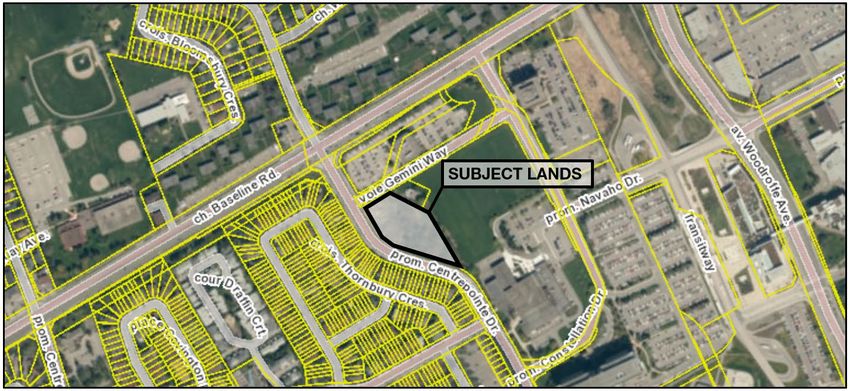
1.0                                                                                                            1
Introduction
Richcraft Homes is seeking to develop the lands known as 19 Centrepointe Drive in the City of Ottawa with a
cluster of two (2) towers proposed at 22 and 24-storeys respectively. This Planning Rationale has been
provided as part of the Site Plan Control application required to proceed with the development.

1.1        Subject Site
As shown in Figure 1, 19 Centrepointe Drive (the ‘subject lands’) is located south of Baseline Road, west of
Woodroffe Avenue along Centrepointe Drive. The subject lands are legally described as PLAN 4M-623 BLK 25
LESS RP;4R-7298 PART 16.

Figure 1. 19 Centrepointe Drive - the 'subject lands'.

1.2        Application Summary
This Planning Rationale is submitted in support of a Site Plan Control application. 19 Centrepointe Drive is the
subject of two applications, being an Official Plan Amendment and a Zoning By-law Amendment application
(File Nos. D01-01-20-0005 and D02-02-20-0027).

The Zoning By-law Amendment was required for the following reasons:
   /   Revise the Floor Space Index cap of 3.0 to 4.52;
   /   Permit an interior side yard tower setback of 5.86 m;
   /   Replace Schedule 299 with a new schedule that aligns with the proposed building heights and
       setbacks.

The Official Plan Amendment is required to amend the Baseline Woodroffe Secondary Plan to permit site
specific height and density above what is contemplated in the Secondary Plan.

May 2021                                                        19 Centrepointe Drive
                                                                Planning Rationale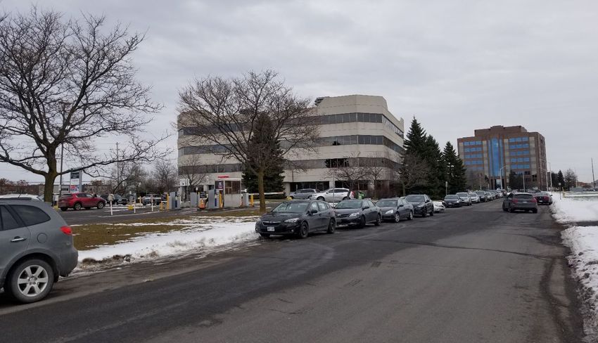
2
1.3 Application History
In 2011, an application for a Zoning By-law Amendment (D02-02-11-0096) was submitted by Richcraft Homes
to amend the zoning of the subject lands to permit a two (2) tower design at 22 and 24-storeys respectively.
The amendment was required to permit an increase in height from 30 metres to 74 metres and to permit a Floor
Space Index (FSI) of 3.0 when 2.5 was permitted. Following a submission to the Urban Design Review Panel at
the time, the proposed development was revised to three (3) 15-storey towers. A Zoning By-law Amendment
was still required in order to permit an increase in height from 30 metres to 49 metres and an increased FSI
from 2.5 to 3.0 in addition to the following site-specific exceptions:
/ no parking is required for the first 350 square metres of gross floor area for a restaurant,
/ an outdoor commercial patio may be located within 15 metres of a residential zone and is not required
to be screened and physically separated from the residential zone by a building, structure, fence or wall
that is at least 2 metres in height
/ uncovered, unenclosed platforms where the walking surface is not higher than 1.5 m above adjacent
grade – no maximum projection into a required yard and no minimum setback from a lot line
Following approval of the revised Zoning By-law Amendment, Richcraft proposed a phased approach to
development that would see a full build out over approximately five (5) years. It is our understanding that this
development proposal was not pursued due to the changing market demand.
In 2020, a revised development proposal was brought forth by Richcraft. In this latest iteration, it was initially
proposed that three (3) towers would be developed at heights of 22, 24, and 26-storeys respectively with a
shared podium base. This proposal required applications for an Official Plan Amendment and a Zoning By-law
Amendment (File Nos. D01-01-20-0005 and D02-02-20-0027). Over the course of the application process, the
design was revised to a two-tower configuration with heights of 22 and 24-storeys each. Additional adjustments
and changes to the design resulted in the proposed development presented as part of this application.
1.4 Area Context
The subject lands are located along Centrepointe Drive, just off Baseline Road in the Centrepointe
neighborhood of the City of Ottawa. This area of the Centrepointe Community can be generally characterized
by a mix of residential, institutional and employment uses (Figure 2). Centrepointe Drive effectively acts as the
transition point from employment uses on its east side to residential uses on its west side. Baseline Road and
Woodroffe Avenue are the major arterials of the area and handle the majority of traffic coming to and from the
area. The Baseline Woodroffe Transit Station is located approximately 415 metres away from the subject lands
and is slated to be converted to a Light Rail Transit Station as part of Phase 2 of the Confederation West Line
project, currently underway.
North
Located north of the subject lands is a medical laboratory building accessed via Gemini Way which also
features a private parking lot. Adjacent to this building, a student residence is proposed at 11-storeys at 2140
Baseline Road. North of Baseline Road are a number of low-rise dwellings in varying typologies, including low-
rise apartment buildings, detached and semi-detached dwellings. Additionally, the Pinecrest Recreation
Complex and Barbara Ann Scott Arena are located adjacent to the Bishop Hamilton Montessori School and the
recreational facilities of Pinecrest Park. The Transitway and Cross-Town Bikeway are located approximately
600 metres north east of the site and are accessible via the pedestrian connections from Woodroffe Avenue.
East
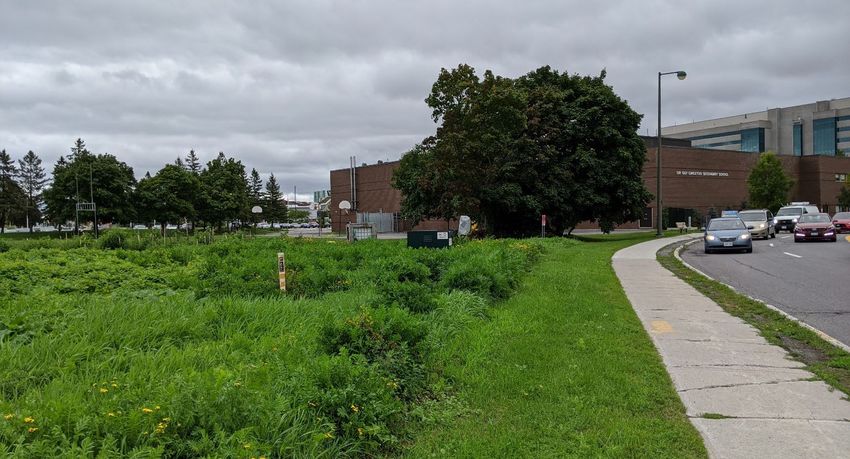
Directly abutting the subject lands to the east is the Sir Guy Carleton Secondary School site, which includes
two (2) soccer fields and a parking area. The Woodline Building east of Constellation Drive is a government
office building standing at 8-storeys with associated parking lots. Further east is a large parking area serving
the Provincial Courthouse and just beyond that is the Baseline Woodroffe Transit Station. East of Woodroffe
May 2021 19 Centrepointe Drive
Planning Rationale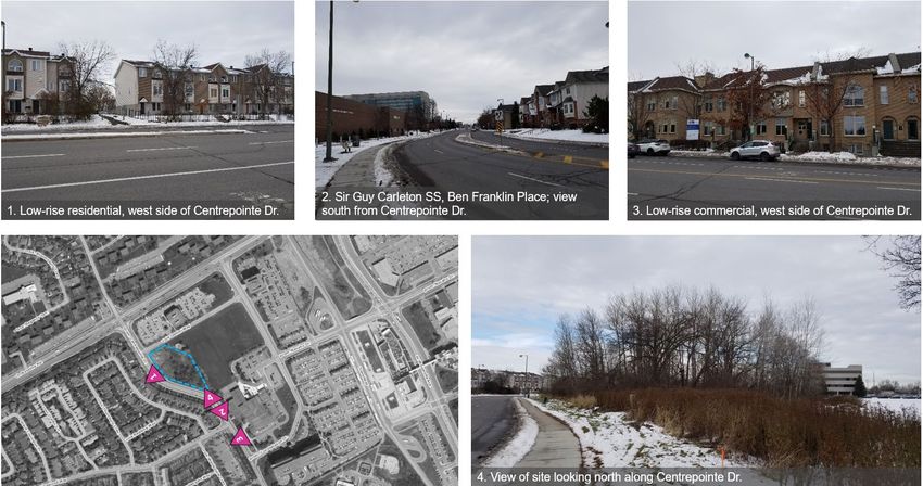
3
Avenue is the Algonquin College campus and slightly north of the campus is the College Square shopping
area, which features a number of commercial uses and large surface parking areas.
South
On the east side of Centrepointe Drive and south of the subject lands is the Sir Guy Carleton Secondary
School building adjacent to the Provincial Offences Courthouse and the Ben Franklin Place Client Service
Centre of the City of Ottawa. Beyond this, some commercial and restaurant uses are located adjacent to the
Peter D. Clark Long Term Care Centre and the retirement community surrounding it. West of Centrepointe
Drive and south of the subject lands is a large pocket of low-rise residential dwellings accessible from
Centrepointe Drive via Hemmingwood Way. Centrepointe Park and linkages to the greater multi-use pathway
network are located just beyond this neighborhood.
West
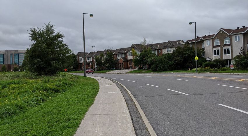
The area west of the subject lands is almost entirely characterized by low-rise residential dwellings of varying
typologies including detached and semi-detached dwellings, low-rise residential apartment buildings, and
townhouses. A small number of mid-rise apartment buildings are interspersed in the neighborhood, generally in
proximity to Baseline Road. Some small commercial uses and home-based businesses are sprinkled
throughout the neighborhood.
Figure 2. Neighborhood context surrounding the subject lands.
May 2021 19 Centrepointe Drive
Planning Rationale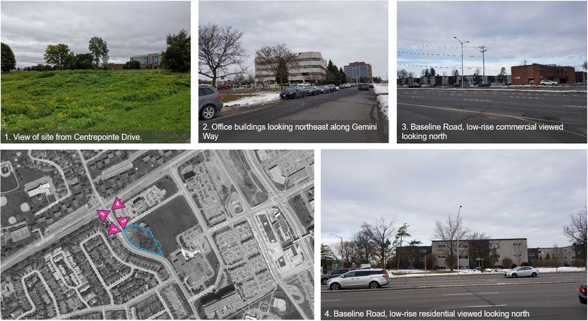
4

Figure 3. View looking south along Centrepointe Drive showing low-rise dwellings across the road.

Figure 4. View looking north across Baseline Road from the intersection with Centrepointe Drive.

May 2021                                                                      19 Centrepointe Drive
                                                                              Planning Rationale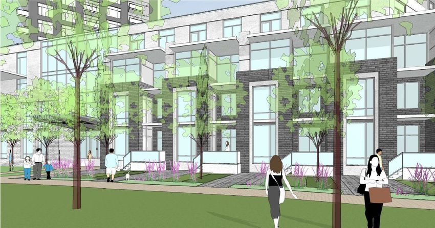
5

Figure 5. View of the south end of the property looking towards Sir Guy Carleton Secondary School.

Figure 6. View looking east along Gemini Way.

May 2021                                                                     19 Centrepointe Drive
                                                                             Planning Rationale
6
1.5        Road Network
As per Schedule E Urban Road Network of the City of Ottawa’s Official Plan (Figure 7), the subject lands are
located on Centrepointe Drive which is identified a major collector road. The Official Plan identifies major
collector roads as those that serve neighborhood travel between collector and arterial roads and may provide
direct access to adjacent lands. Baseline Road is an arterial road located approximately 100 metres north of
the subject lands and accessible via an intersection with Centrepointe Drive.

Figure 7. City of Ottawa Official Plan - Schedule E Urban Road Network.

May 2021                                                                  19 Centrepointe Drive
                                                                          Planning Rationale
7
1.6 Rapid Transit Network
As demonstrated on Schedule D Rapid Transit Network of the City of Ottawa’s Official Plan (Figure 8), the
subject lands are located in proximity to rapid transit. The proposed development is located approximately 450
metres (625 metres walking distance along public sidewalks and streets) from the Baseline Rapid Transit
Station which currently serves residents as a bus rapid transit facility, however, as part of the Stage 2
Confederation Line West Extension project the Baseline Station is planned to be converted to Light Rail
Transit.
Figure 8. City of Ottawa Official Plan - Schedule D Rapid Transit Priority Network.
May 2021 19 Centrepointe Drive
Planning Rationale8
1.7 Cycling Network
Schedule C Primary Urban Cycling Network of the City of Ottawa’s Official Plan (Figure 9) identifies Baseline
Road as a Spine Route for cycling travel and is located approximately 100 metres north of the subject lands.
Several off-street multi-use pathways are accessible from the subject lands, including those which follow the
Transitway off Baseline Road and Woodroffe Avenue.
Figure 9. City of Ottawa Official Plan - Schedule C Primary Urban Cycling Network.
May 2021 19 Centrepointe Drive
Planning Rationale2.0 9
Proposed Development
The proposed development consists of two (2) towers, Tower A and Tower B, standing at 22 and 24-storeys
respectively. Tower A is proposed to include 198 dwellings units while Tower B is proposed to include 218
dwelling units for a total of 575 dwelling units. The units are a mix of the following unit types:
Unit Statistics Number of Units
Studio Unit 3
One Bedroom Unit 77
One Bedroom + Den Unit 316
Two Bedroom Unit 158
Two Bedroom + Den Unit 21
Figure 10. Site plan demonstrating the proposed development at 19 Centrepointe Drive.
The ground floor residential units are accessible individually from the exterior of the building, rather than
internally as each has its own outdoor terrace space with steps and an entrance. The ground floor units and
podium are designed to reflect their individual entrances, which creates a low-rise interface along Centrepointe
Drive and Gemini Way as well as within the site that encloses the street in a pedestrian friendly manner. The
podium wall is animated and responds well to the pedestrian environment by incorporating significant glazing,
glass curtain walls at key points, articulated and recessed entrances, and interior courtyards and amenity
spaces which break up the massing between towers. The courtyard will allow residents and pedestrians to
easily access Gemini Way from Centrepointe Drive and vice versa as well as circulate within the site.
May 2021 19 Centrepointe Drive
Planning Rationale10
Figure 11. Ground oriented units and entrances at grade.
Access to the site is proposed via a driveway from Gemini Way leading to the interior of the development and
the courtyard space. A small loop is proposed to permit easy drop off for residents in addition to a ten (10)
surface parking spaces for delivery or visitors. Additionally, a loading bay is proposed for each tower to be
accessed via the driveway to serve the garbage collection and other deliveries or pickups. Three (3) levels of
underground parking are proposed and will be shared between both of the towers. A total of 499 vehicle
parking spaces (slightly less than 1 per unit) and 612 bicycle parking spaces are proposed for the site. The
parking garages also include bicycle tune up and maintenance spaces in addition to storage space for
residents.
Several communal amenity spaces are provided for the residents in each tower in addition to private amenity
spaces. A total of 4,205 square metres of amenity space is proposed with 2,275 square metres of communal
amenity area planned. This includes 500 square metres of amenity area at grade where an outdoor court and
recreational space is planned. At grade units have ground floor terraces while the towers feature a number of
terraces and private balconies. The podium amenity spaces are designed with a communal terrace and
landscaped roof above the 5th level and above the 4th level the space features a pool and lounging area on the
terrace.
The configuration of the towers on the site are such that the podiums front Centrepointe Drive and the towers
above are angled to face the street, matching the curved contour of the right-of-way. This façade acts as the
public realm frontage with two secondary entrances along Centrepointe Drive. The other side of the building
acts as the front as it includes the access off Gemini Way, the main entrance, loading areas, and underground
parking garage ramps. The 3-storey podium and ground-oriented units act as the base of the building and
feature dark grey brick with white cladding accents and glazing. These materials are repeated throughout the
design of the tower and aid to highlight transitions and articulations at the upper levels.
May 2021 19 Centrepointe Drive
Planning Rationale11
2.1 Public Consultation Strategy
Following pre-application consultation with City of Ottawa staff, a meeting was held with the Centrepointe
Community Association to discuss the proposed development and identify any early concerns the community
might have with the project. The meeting held on November 12th, 2019 resulted in a constructive discussion
with several members of the association and they were able to share their concerns with potential traffic issues
brought on by additional residents in the area, the height and density being proposed, and a lack of parking
resulting in overflow on local streets.
A public consultation meeting was held on November 9th, 2020, however, with the onset of the COVID-19
pandemic, all public gatherings and events were scheduled as a virtual consultation. Additional comments and
issues were taken into consideration at this meeting and further changes to the proposed development were
completed resulting in the design that is presented as part of this Site Plan Control application.
May 2021 19 Centrepointe Drive
Planning Rationale3.0 12
Policy & Regulatory Framework
3.1 Provincial Policy Statement (2020)
Ontario’s Ministry of Municipal Affairs and Housing has released the latest version of the Provincial Policy
Statement (2020) on February 28th, 2020. The Provincial Policy Statement (PPS) establishes province-wide
standards for how we use land and resources and guides decision-making on key land use issues across
Ontario. These initiatives will help Ontario deal with the affordable housing crisis that has been created over the
past 15 years.
The applicable policies of the PPS to the proposed development, among others, are listed for reference below:
/ Promoting efficient development and land use patterns which sustain the financial well-being of the
Province and municipalities over the long term;
/ Accommodating an appropriate affordable and market-based range and mix of residential types
(including single-detached, additional residential units, multi-unit housing, affordable housing and
housing for older persons), employment (including industrial and commercial), institutional (including
places of worship, cemeteries and long-term care homes), recreation, park and open space, and other
uses to meet long-term needs;
/ avoiding development and land use patterns which may cause environmental or public health and
safety concerns;
/ promoting the integration of land use planning, growth management, transit-supportive development,
intensification and infrastructure planning to achieve cost-effective development patterns, optimization
of transit investments, and standards to minimize land consumption and servicing costs;
/ promoting development and land use patterns that conserve biodiversity;
/ preparing for the regional and local impacts of a changing climate;
/ are appropriate for, and efficiently use, the infrastructure and public service facilities which are planned
or available, and avoid the need for their unjustified and/or uneconomical expansion;
/ support active transportation;
/ are transit-supportive, where transit is planned, exists or may be developed;
/ Planning authorities shall identify appropriate locations and promote opportunities for transit-supportive
development, accommodating a significant supply and range of housing options through intensification
and redevelopment where this can be accommodated taking into account existing building stock or
areas, including brownfield sites, and the availability of suitable existing or planned infrastructure and
public service facilities required to accommodate projected needs.
/ New development taking place in designated growth areas should occur adjacent to the existing built-
up area and should have a compact form, mix of uses and densities that allow for the efficient use of
land, infrastructure and public service facilities.
/ Planning authorities shall provide for an appropriate range and mix of housing options and densities to
meet projected market-based and affordable housing needs of current and future residents of the
regional market area by:
- permitting and facilitating:
• all housing options required to meet the social, health, economic and well-being requirements
of current and future residents, including special needs requirements and needs arising from
demographic changes and employment opportunities; and
• all types of residential intensification, including additional residential units, and redevelopment
in accordance with policy 1.1.3.3;
/ directing the development of new housing towards locations where appropriate levels of infrastructure
and public service facilities are or will be available to support current and projected needs;
/ promoting densities for new housing which efficiently use land, resources, infrastructure and public
service facilities, and support the use of active transportation and transit in areas where it exists or is to
be developed;
May 2021 19 Centrepointe Drive
Planning Rationale13
/ requiring transit-supportive development and prioritizing intensification, including potential air rights
development, in proximity to transit, including corridors and stations; and
/ establishing development standards for residential intensification, redevelopment and new residential
development which minimize the cost of housing and facilitate compact form, while maintaining
appropriate levels of public health and safety.
The proposed development is in conformity with the intent and policies of the updated Provincial Policy
Statement (2020).
3.2 City of Ottawa Official Plan (2003, as amended)
3.2.1 Mixed Use Centre
The subject lands are designated ‘Mixed Use Centre’ on Official Plan Schedule B (Urban Policy Plan), as
demonstrated in Figure 12. Mixed Use Centres occupy strategic locations in the City in proximity to the rapid
transit network and act as central nodes of activity within their surrounding communities and the City of Ottawa
as a whole. These areas have the potential to achieve high densities through development of vacant lands into
compact, mixed-use communities oriented to rapid transit. In many mixed-use centres, the mix of uses is
incomplete and there is a need for housing to achieve the area’s potential to become a complete, liveable
community.
Policy 1 of Section 3.6.2 outlines the following criteria for Mixed Use Centres:
/ Most of the centre is within an 800m walking distance of one or more rapid transit stations, and
contains one or more arterial roads with all day, frequent transit service;
/ There is opportunity to achieve high densities of jobs and housing through intensification and
redevelopment of older sites and development of vacant land;
/ High-Rise Buildings of 10 storeys and more can be accommodated in a manner that provides
appropriate transition to the surrounding area;
/ Employment targets of at least 5,000 jobs can be achieved in Mixed Use Centres and at least 10,000
jobs can be achieved in Town Centres;
/ The area is or can become transit-oriented, as described in this section;
/ The area is suitable for a mix of uses and could be linked within the area’s greenspace network.
The addition of 575 dwelling units to the underdeveloped, vacant lands at 19 Centrepointe Drive will
contribute to higher, transit supportive densities within walking distance of the Baseline Rapid Transit
Station.
Policy 3 states that Mixed Use Centres are priority areas for undertaking more detailed Secondary Plans.
These plans may:
/ Provide for minimum and maximum building heights;
/ Apply the target density for the area identified in Figure 2.3, or require different densities to be achieved
on a site-specific basis such that, over time, the overall target density is achieved for the area;
/ Develop area-specific design considerations.
An amendment to the existing Baseline Woodroffe Secondary Plan policies has been completed as part
of the Official Plan Amendment application (D01-01-20-0005).
Policy 5 contemplates a broad variety of land uses permitted within Mixed Use Centres at transit-supportive
densities, such as offices, secondary and post-secondary schools, hotels, hospitals, large institutional
buildings, community recreation and leisure centres, daycare centres, retail uses, entertainment uses, services
(such as restaurants), high- and medium-density residential uses and mixed-use development containing
combinations of the foregoing. Major Urban Facilities are permitted as set out in Section 3.6.7.
May 2021 19 Centrepointe Drive
Planning Rationale14
The proposed development consists of two (2) towers, which are defined as High-rise apartment
dwellings in the Zoning By-law and considered high density residential uses. In discussions with
Planning and Design staff as well as comments received from the Urban Design Review Panel, changes
to the design were made to provide adequate transition to the low-rise dwellings located approximately
45 metres away across Centrepointe Drive.
Figure 12. City of Ottawa Official Plan - Schedule B Urban Policy Plan.
Policy 9 further states that all development applications and Community Design Plans for Mixed-Use Centres
will be reviewed in the context of this Plan and in particular:
/ Will be evaluated in the context of the Design Objectives and Principles in Section 2.5.1 and the criteria
set out in Section 4.11, particularly with regard to achieving a compact, mixed-use, transit-oriented,
pedestrian-friendly environment and creating a place with visual interest;
/ Will, where possible, contribute to a range of housing options in the area.
The policies of Section 2.5.1 and 4.11 are discussed in detail below. The proposed high-rise apartment
dwellings would be the first high rise residential housing options to locate within the area of the Mixed-
Use Centre and offers a new housing option in the area.
Policy 10 states that Mixed-Use Centres will optimize the use of land through provisions for compact mixed-use
development. The Zoning By-law and community design plans will:
/ Require employment and housing as part of a larger mix of uses and permit a mix of uses within a
building or in adjacent buildings;
/ Require residential uses in the form of apartments and other multiples at a medium or high density;
/ Provide for the potential for shared parking arrangements among uses that peak at different time
periods;
May 2021 19 Centrepointe Drive
Planning Rationale15
/ Allow for the potential redevelopment of surface parking areas;
/ Not permit uses that require large areas of their site to be devoted to the outdoor storage, sale or
service of goods to be located within 800 metres walking distance of a rapid transit station;
/ Ensure that an appropriate transition in built form between the Mixed-Use Centre and any surrounding
General Urban Area occurs within the Mixed-Use Centre site
The proposed development includes housing in the form of high-rise apartment dwellings at transit
supportive densities with appropriate transition to low-rise residential dwellings in the area.
Policy 11 states that plans, public works and development proposals for Mixed-Use Centres will enhance
opportunities for walking, cycling and transit and in particular will:
/ Give priority to walking and cycling in public rights-of-way;
/ Provide direct, barrier-free connections for pedestrians and cyclists linking transit and other
developments in the Mixed-Use Centre along public rights-of-way, off-road pathways and open space
connections;
/ Use public art and the design of public streets and spaces to create attractive public areas;
/ Provide adequate, secure, and highly visible bicycle parking at rapid transit stations and throughout the
Centre;
/ Design transit shelters, seating and other facilities that contribute to attractive public areas and that
enhance personal security through such measures as described in Section 4.8.
Pathways and pedestrian connections to sidewalks are provided on site and from the subject lands to
other areas of the Mixed-Use Centre, effectively linking the proposed development to the transit station
via sidewalks. A total of 612 bicycle parking spaces are proposed for the underground parking garage
areas in addition to bicycle maintenance areas to support active transportation for residents.
3.2.2 Managing Growth
Approximately 90% of the growth in the City of Ottawa is to be accommodated within the urban boundary
where services are readily available or can be easily provided. This approach efficiently uses existing facilities
and infrastructure while providing the least impact on agricultural lands, mineral resources, and environmental
areas. This growth strategy is to be implemented through:
/ Intensification and infill; and
/ New development on vacant lands in designated growth areas that contributes to the completion of
an existing community or builds a new community.
Policy 1 of Section 2.2.2 defines residential intensification as the intensification of a property, building or area
that results in a net increase in residential units or accommodation and includes [among others]:
/ The development of vacant or underutilized lots within previously developed areas, being defined as
adjacent areas that were developed four or more years prior to new intensification; and
/ Infill development.
Policy 3 contemplates Mixed-Use Centres as a target area for intensification. Policy 5 identifies minimum
density targets, expressed in jobs and people per gross hectare, including a density target of 200 people and
jobs per hectare for the Baseline-Woodroffe Mixed-Use Centre area. Policy 6 also states that new development
within intensification areas is required to meet the density targets for that area, however, higher or lower
densities may be prescribed in a secondary plan where that plan re-allocates density among site to achieve the
overall density objective.
The proposed development falls under the residential intensification definition and is within a Mixed-
Use Centre, a target area for intensification. There are few examples of existing mid to high rise
apartment buildings within the Baseline Woodroffe Mixed Use Centre planning area while the remainder
of the area contains low-rise residential dwellings and other non-residential uses. The introduction of
May 2021 19 Centrepointe Drive
Planning Rationale16
high-density residential dwellings will offset the lack of existing density and aid in achieving the Official
Plan’s target density.
Policy 10 states that intensification may occur in a variety of built forms from low-rise to high-rise provided
urban design and compatibility objectives are met. Denser development, that often means taller buildings,
should be located in areas that support the Rapid Transit and Transit Priority networks and in areas with a mix
of uses. Building heights and densities for different areas may be established through this plan or a secondary
plan and will be implemented through zoning. A secondary planning process identified in Section 2.5.6 and
undertaken for a specific area may recommend a new or changes to an existing secondary plan to establish
different building heights. Low-rise intensification will be the predominant form of intensification in the General
Urban Area.
Urban Design and Compatibility are discussed in greater detail below. The subject lands are located
approximately 600 metres walking distance from the Baseline Rapid Transit Station and the
development is proposed at heights and densities capable of supporting the Rapid Transit Network. As
part of this development, an amendment to the Baseline-Woodroffe Secondary Plan has been requested
and approved to permit transit supportive densities and amend the maximum 0.4 Floor Space Index
provision for the subject lands in the Secondary Plan.
Policy 11 contemplates the distribution of appropriate building heights which will be determined by:
/ The location in a Target Area for Intensification identified in policy 4 above or by proximity to a Rapid
Transit station or Transit Priority corridor, with the greatest density and tallest building heights being
located closest to the station or corridor; and
/ The Design and Compatibility of the development with the surrounding existing context and planned
function, as detailed in Section 4.11, with buildings clustered with other buildings of similar height.
The proposed height and density have been revised from the initial proposal’s three towers at heights
of 22, 24, and 26-storeys to a two-tower configuration proposed at heights of 22 and 24-storeys each.
The reduction in height and density reduces the impacts of massing and shadowing to the low-rise
residential areas located across Centrepointe Drive.
The target areas for intensification referred to in Policy 3 include the Central Area, Mixed Use Centres,
Mainstreets, and Town Centres defined on Schedule B, and the Community Core in Riverside South.
The proposed development is in an identified Target Area for Intensification (Mixed-Use Centre) as well
as in proximity to a transit station.
Though we recognize the planning argument for putting the tallest buildings with the highest density
closest to the transit station, in practice this is not always possible. Existing development and physical
constraints such as roadway patterns, parks or green spaces, transit facilities, infrastructure
limitations, or other factors can reduce the feasibility of this Transit Oriented Development strategy. In
fact, the City of Ottawa’s own Transit Oriented Development Plans outline the estimated land area that
is available for future development capable of achieving transit-supportive densities. Using the
example of the Cyrville TOD Plan, after excluding transportation and utility corridors only 64% of the
planning area is available for development and of this net area only 32% is vacant, infill or
underdeveloped land that is available for development in the short term. The Centrepointe area reflects
similar conditions in that a consistent pattern of density and development may not be achieved due to
existing conditions and constraints.
Again, using the Cyrville TOD Plan as an example we can see that based on the physical constraints
and percentage of area available for development that a Density Range & Maximum Building Height
Plan (Figure 13) is proposed for the TOD area. The areas where the tallest buildings can be
accommodated are displayed in red and, though the highest concentration of density and height is
located close to the transit station, there are also other areas where heights up to 30-storeys are
contemplated. This includes areas on the periphery and outside of the 600-metre radius from the transit
May 2021 19 Centrepointe Drive
Planning Rationale17
station and which are in close proximity to established low-rise residential areas. Figure 14
demonstrates the actual existing conditions of an edge of the Cyrville TOD area and which lands are
proposed as high density and tall building appropriate. The numbers on the image correspond to
maximum building height contemplated in that location. This edge condition of the TOD plan closely
resembles the conditions of Centrepointe Drive and the proposed development as 30-storey heights are
contemplated approximately 600 metres from the transit station and abutting an existing low-rise
residential area.
Figure 13. Cyrville Density Range and Maximum Building Height.
May 2021 19 Centrepointe Drive
Planning Rationale18
Figure 14. Cyrville TOD Density and Heights demonstrated at Ogilvie Road.
There are many other examples in the City of Ottawa where the tallest building will not be the one
closest to the transit station, most notably Ottawa’s tallest building the Claridge Icon (45-storeys)
which is located approximately 140 metres from the Carling transit station, however, other buildings
existing or proposed within a similar distance or closer to the transit station will be lower. One example
is the Soho Italia development at 490-500 Preston Street proposed at 30-storeys and located west of the
Claridge Icon approximately 90 metres away from the Carling transit station.
The Location of High-Rise and High-Rise 31+ buildings is influenced by the need to provide an adequate
separation distance from other existing and potential future High-Rise buildings. Separation distances between
buildings are to be considered when considering sites for development of High-Rise buildings and High-Rise
31+ buildings. The City may implement separation distances through the Zoning By-law. In areas with a small
or narrow lot fabric, consolidation of two or more lots may be in order to address separation distance
requirements.
Adequate (20+ metres) separation is provided between both towers on the subject lands and no
abutting lands are zoned for residential or mixed-use dwellings, however, adequate setbacks and
separation distance to abutting properties is maintained.
Policy 17 dictates that ‘for Official Plan amendments to increase building heights that are established in Section
3 of this Plan, or in a secondary plan, the proponent must demonstrate that the following criteria are met:
/ the impacts on the surrounding area (e.g. the community design plan study area) have been assessed
comprehensively;
/ the direction in policy 10 above is met;
/ the requirements of Section 2.5.6 where the proposal involves a High-Rise or High-Rise 31+ building;
and
/ an identified community amenity is provided.
May 2021 19 Centrepointe Drive
Planning Rationale19
As part of the application, supporting studies have been submitted which evaluate the impacts of the
proposed development on the surrounding area. The proposed development meets the provisions of
Policy 10, as discussed above. A Section 37 contribution has been negotiated with staff and the local
Councillor as part of the Zoning By-law Amendment approval.
3.2.3 Urban Design and Compatibility
Section 2.5.1 – Designing Ottawa of the City of Ottawa’s Official Plan outlines a number of design objectives,
detailed below, which should be considered when reviewing development applications. The proposed
development responds to these design objectives in the following ways:
To enhance the sense of The introduction of new residential dwellings in the proposed high-
community by creating and rise format will create a new pocket of residents in the Centrepointe
maintaining places with their own community and contribute to the Transit Oriented identity of the area.
distinct identity. Additionally, the proposed development will help achieve the targeted
density for this planning area.
To define quality public and The design of the clustered towers incorporates open spaces that
private spaces through blend into the surrounding area, such as the courtyard and looped
development driveway in the interior of the site. The introduction of a secondary
entrance space between Tower A and B plus amenity terraces above
the podium create a unique space that is visually interesting and
attractive. The pedestrian pathways along the street and connections
from ground oriented units, open spaces, and amenity areas to
Centrepointe Drive frame the edge of the street and provide
animation.
To create places that are safe, Safe access to the site by vehicle is proposed from Gemini Way
accessible and are easy to get to. rather than directly onto Centrepointe Drive. Pedestrian pathways
and access to linkages to transit are incorporated in the design of the
site. Additionally the development will increase the natural
surveillance of the adjacent park space and sidewalk along
Centrepointe. Lay by parking is proposed along Centrepointe Drive
abutting the site which will add some parking to the street.
To ensure that new development To mitigate the impacts of the towers on low-rise residential dwellings
respects the character of existing across Centrepointe Drive, the podium was broken up and gaps
areas. introduced between the towers to reduce the imposing streetwall
facing the dwellings. The angled configuration of the towers allows for
sun to fall on neighboring properties without completely blocking out
the light. Stepping down of upper floors in addition to a layered
podium provide additional transition.
To consider adaptability and As the Centrepointe community evolves towards more Transit
diversity by creating places that Oriented Development, the introduction of high-rise dwelling units
can adapt and evolve easily over offers a type of housing choice that is limited in the area.
time and that are characterized by
variety and choice.
To understand and respect Landscaping and stormwater infrastructure will serve to manage post
natural processes and features in development flows of water runoff on the property. The provision of
development design. the green roof will also capture some rainwater and aid in reducing
the urban heat island effect.
May 2021 19 Centrepointe Drive
Planning Rationale20
To maximize energy-efficiency The angles and configuration of the towers in addition to a high
and promote sustainable design degree of glazing allows for maximizing the capture of sunlight and
to reduce the resource heat. The proximity to transit and provision of bicycle parking
consumption, energy use, and provides support for alternative modes of transportation.
carbon footprint of the built
environment.
Policy 2 identifies Mixed-Use Centres as Design Priority Areas which will be reviewed for their contribution to
an enhanced pedestrian environment and the distinct character and unique opportunities of the area. The
Ottawa Urban Design Review panel will review the urban design elements of the proposed development.
The proposed development was presented to the UDRP on two separate occasions on December 6th,
2019 and again for a formal meeting on January 8th, 2021. Comments from the panel were reviewed and
incorporated into the design presented as part of this application submission.
Section 4.11 – Urban Design and Compatibility discusses policies which speak to design elements of the
proposal and how they fit into the context of their surroundings. Policy 2 provides compatibility criteria used for
evaluating the compatibility of development applications, as follows:
Views
/ The revised height of the towers at 22 and 24-storeys tall are considered to be high-rise, however, they
are not in an area with protected viewsheds and therefore will have no impacts on views.
Building Design
/ The removal of the centre 26-storey tower allowed for a podium to take its place in order to maintain
visual and physical connectivity between the two remaining towers now proposed at 22 and 24-storeys
(Figure 15). The podium frames the street and follows the curve of Centrepointe Drive, effectively
creating an entire new pedestrian-oriented frontage.
/ Ten (10) lay by parking spaces are proposed along Centrepointe Drive for additional parking or pickup
along this frontage.
/ The interior courtyard and roundabout accessed from Gemini Way continues to be the main entrance
area and will also feature some outdoor seating spaces, landscaping and trees, a communal garden,
and pathways to connect within the site. Loading spaces are also proposed to be accessed via the
roundabout.
/ Material colours have been lightened and organized to reduce the visual impact of the towers.
/ Varying window sizes above create a visual transition to the floors above.
/ Glass spandrel curtain walls were also present in the previous design; however, the revised design
utilizes the curtain walls to frame the edges of each tower and essentially “bookend” the development.
/ The number of private balconies on each tower has been reduced in favour of larger communal
amenity areas, such as the outdoor amenity area with swimming pool at the 5th storey podium as well
as the outdoor recreational area at grade proposed for the south side of the site. Punched in and
cantilevered balconies continue to be proposed for many units though.
/ The podium facing Centrepointe Drive will feature ground-oriented units with landscaped entrances and
amenity areas as well as a new alternate lobby entrance. The lobby entrance forecourt is attractively
designed with seating and pedestrian amenities as demonstrated in Figure 16.
/ Above the podium, a green roof is proposed in combination with the amenity terrace area which
contributes to the reduction of heat island effects and provides an attractive space for residents.
May 2021 19 Centrepointe Drive
Planning Rationale21
Figure 15. View from Centrepointe Drive looking north.
Massing and Scale
/ The south tower and podium were re-designed to fit into the tapered section of the property at the south
property line. This results in a slightly wider tower footprint and a podium that follows the contour of the
street, seeking to mirror the existing low-rise across Centrepointe Drive (Figure 17).
/ The podium is proposed at 5-storeys with a transition down to 4-storeys along Centrepointe Drive
where the rooftop amenity area is proposed and a second transition down to the main podium section
with 3 storeys (Figure 18). The removal of the tower and addition of the continuous podium element
has improved the transition towards the low-rise residential dwellings across Centrepointe Drive, where
the potential for impact is the greatest.
/ The main 3-storey podium section reflects the low-rise typology across Centrepointe Drive.
/ The orientation of the towers has been adjusted so that both towers are parallel to each other and
reduce the mass of the building wall facing low-rise residential dwellings across Centrepointe Drive.
May 2021 19 Centrepointe Drive
Planning Rationale22
Figure 16. Landscape plan for the forecourt along Centrepointe Drive.
Figure 17. View of tapered podium and tower from the south side of the property along Centrepointe Drive.
May 2021 19 Centrepointe Drive
Planning Rationale23
Figure 18. Podium transition towards Centrepointe Drive.
/ Policy 13 of Section 4.11 provides guidance on achieving transition. The revised design meets the
policy in the following ways:
- Incremental changes in building height.
- A 45-degree angular plane drawing is presented below in Figures 19 and 20. It demonstrates an
angular plane measured from the height of the roofline and at the façade of the low-rise residential
dwellings across Centrepointe Drive. Though the proposed design does not meet the angular
plane, its intent is generally maintained as only a small portion of the upper floors and the
mechanical penthouse are bisected by the plane.
May 2021 19 Centrepointe Drive
Planning Rationale24
Figure 19. 45-degree angular plane demonstration – Tower A.
Figure 20. 45-degree angular plane demonstration – Tower B.
/ The ground oriented dwelling units form part of the podium (Figure 21). Each unit continues to have
access from the street or within the interior of the site, however, the units are clustered in a manner that
is similar to townhouses in an effort to reflect the existing character of low-rise residential dwellings
across Centrepointe Drive. The middle portion of the podium fronting Centrepointe Drive will also act as
a main entrance for the development from that side and leads into the lobby of the buildings.
/ As demonstrated in Figure 18, the podium transitions down from the 5th storey to the 4th storey outdoor
amenity terrace and again down to the 3rd storey. The 5th storey is stepped back above the outdoor
terrace. The podium at the south end of the building is also stepped back above the 4th storey to
accommodate a communal amenity terrace. Additional stepbacks at the 21st-24th levels of both towers
are able to provide terrace areas and balconies while also creating additional transition. Particularly for
Tower B where the corner closest to Centrepointe Drive is stepped down towards the low-rise
residential area across the street.
May 2021 19 Centrepointe Drive
Planning Rationale25
Figure 21. View of podium and ground oriented dwelling units along Centrepointe Drive.
High-rise Buildings
- The removal of one of the towers will reduce the shadowing impacts of the development on adjacent
properties though it should be recognized that the majority of shadow impacts will fall on areas where no
residential dwellings are located.
- The proposed podium respects the scale and character of the surrounding area by stepping down to
Centrepointe Drive and animating the streetscape with ground oriented dwelling units, pedestrian
amenities, landscaping, and trees.
- Tower separation distance between each tower is proposed at 35.87 metres. The tower setbacks to the
property lines are as follows:
o Front and Corner Yard Tower Setback = 6 metres for Tower A; 7.16 metres for Tower B
o Interior Side Yard Tower Setback = 11.48 metres for Tower A; 6.05 metres for Tower B
- The interior side yard tower setback for Tower B is deficient from the required 10 metre setback but has
been addressed as part of the Zoning By-law Amendment approval.
- The tower floorplates have been revised to 877.2 square metres, which is slightly above the recommended
750 square metre floor plate of the Urban Design Guidelines for High-rise Buildings, however, with the
removal of the middle tower and the re-orientation of the remaining towers to a north-south configuration
there is mitigation of shadow and wind impacts.
.
May 2021 19 Centrepointe Drive
Planning Rationale26
Figure 22. Towers viewed from interior of site looking south west.
Outdoor Amenity Areas
/ The rooftop terraces above the podium containing indoor and outdoor communal amenity areas as well
as the amenity spaces at grade and outdoor plazas provide well designed and attractive features for
residents.
/ The entry courtyard within the site is proposed to be designed with trees and landscaping as well as
areas for residents to sit down and enjoy the space. A community garden is now proposed within this
courtyard area along the eastern edge of the building and will connect to the recreational area through
pedestrian pathways.
/ An outdoor recreational area is proposed at the southern edge of the property abutting the podium
along Centrepointe Drive (Figure 23). The recreational area is proposed to contain a small basketball
court, ping pong tables, and seating for use by the building’s residents. Landscaping and shade trees
will also make the space comfortable for residents and provide an attractive element to the streetscape.
May 2021 19 Centrepointe Drive
Planning Rationale27
Figure 23. Outdoor recreational area proposed along Centrepointe Drive.
Public Art
/ A small public art piece is anticipated for the forecourt area along Centrepointe Drive at this time.
Design Priority Areas
/ The ground floor is designed at 3.24 metres in height.
/ The podium design follows the contour of Centrepointe Drive and the towers are oriented with their
largest façade facing the street.
/ A high degree of glazing is proposed along the podium and at grade, particularly in the centre of the
podium where a glass curtain wall reaches the 4th storey and creates a visual connection between the
towers along Centrepointe Drive.
/ The changing materials and colours of the podium façade help to break up the massing and create a
townhouse cluster appearance for the ground oriented dwelling units.
/ The main entrance is located on the east facing side of the development and is enclosed by the podium
and towers above. The unique shape of the property results in an opportunity to provide a courtyard
and roundabout which accentuates the private residential nature of this part of the building (Figure 24).
May 2021 19 Centrepointe Drive
Planning Rationale28
Figure 24. Landscape plan of internal courtyard and main entrance on the east side of the development.
May 2021 19 Centrepointe Drive
Planning Rationale29
3.3 Baseline and Woodroffe Secondary Plan
The Baseline and Woodroffe Secondary Plan was implemented as a means of directing development to the
area and creating a focal point for business and employment uses with good access to transit. The Secondary
Planning area is demonstrated in Figure 25. The Secondary Plan was initiated in 1999 as part of the former
City of Nepean and was incorporated into the City of Ottawa’s policies in 2003 following amalgamation. The
Secondary Plan has a planning period to 2021 and will be removed from the new Official Plan once it is
approved.
The proposed development meets the following objectives identified in the Secondary Plan:
/ To create a sense of identity and continuity through streetscaping, massing and urban design.
/ To protect for the most dense development which can be accommodated in the Secondary Plan area
over the planning period (2021), while recognizing that this level of development is an interim step in
the evolution of this centre.
/ To strengthen and improve the visual character of the centre.
/ To provide opportunities for a healthy living style through the provision of recreational pathways,
improved public and private pedestrian amenities, well planted greenways and complementary uses
which encourage walking.
/ To provide opportunities for high density residential development.
/ To improve pedestrian and cycling access and linkages between neighbouring communities, across
roads, and among uses within the Secondary Plan area.
/ To develop a land use pattern and transportation system that supports pedestrians, cyclists, transit,
and vehicular traffic.
/ To limit access points into developments from public roads and create a system of internal roads which
provide clear way finding within various precincts in the Secondary Plan Area.
/ To ensure that development within Secondary Plan Area minimises the effect on surrounding
residential communities of through traffic or off-site parking.
/ To ensure that all new developments are designed to facilitate safe and efficient pedestrian movements
and to minimize on-site pedestrian/vehicle conflicts.
/ To optimize transit ridership by improving pedestrian linkages, locating buildings closer to the street,
and modifying transit routes as required.
/ To use all appropriate aspects of traffic demand management, such as mixed land uses, reduced
parking requirements and parking caps, revision of parking pricing, and subsidizing transit passes, as a
tool to minimize the number of people coming to the Secondary Plan Area by private vehicles.
Section 3.1 of the Plan details the approach to transportation and development. A key component of this is
using the capacity of the transportation system as a determinant of the maximum density that can be
accommodated. High density uses should be located close to the transit station and the maximum development
potential is based on no more than 50% of peak period trips being made by car at build out in 2021. The
development potential was derived from the Baseline Woodroffe Primary Employment Centre Transportation
Review Study, and although it is a general indication of what level of density the plan should be able to
accommodate, the plan is intended to be revisited over the years as transportation and land use factors change
over time. The policies further state that generally, office uses are encouraged closest to the station as they are
the most likely to generate high transit ridership while residential, retail and service development is generally
preferred just outside of the 300 metre radius around the station.
May 2021 19 Centrepointe Drive
Planning Rationale30
Figure 25. Baseline and Woodroffe Secondary Plan Schedule 1 - Plan Boundary.
May 2021 19 Centrepointe Drive
Planning Rationale31
Figure 26. Baseline and Woodroffe Secondary Plan Schedule 2 - Planning Precincts.
Land use and urban design is discussed in Section 3.3 of the Plan. Schedule 2 of the Plan (Figure 26) identifies
the planning precincts of the Secondary Plan area. The subject lands are located within the Constellation
Precinct. The plan states that development on lands located within a 300-metre radius of the transit station
should generally be developed at a Floor Space Index (FSI) of 1.0 and land outside of the 300-metre radius
should be developed at an FSI of 0.4. The subject lands fall outside of the 300-metre radius and therefore are
subject to the 0.4 FSI. However, the plan states that all precincts should be developed as integrated units
which contain a mix of complementary uses, further detailed in the Precinct Policies.
The proposed development would not meet the established FSI of 0.4 for the Constellation Precinct. As
part of the Official Plan Amendment application (D01-01-20-0005), the FSI has been amended to reflect
the proposed development.
Section 3.4.1 outlines the policies specific to the Constellation Precinct where the subject lands are located.
This precinct is intended to accommodate the largest office component of the four precinct areas; however,
residential uses are encouraged adjacent to existing residential dwellings along Centrepointe Drive. The
policies further state that the Constellation Precinct has a development potential of approximately 111,000
square metres, not including the floor area of the existing secondary school and 400 housing units which can
be supported by the transportation network.
May 2021 19 Centrepointe Drive
Planning Rationale32
Policy 6 of Section 2.2.2 of the Official Plan contemplates the minimum density targets stated in table 2.3 as
follows: “All new development within the boundaries of the intensification target areas listed in Figure 2.3 will be
required to meet the minimum density targets. Higher or lower densities may be permitted in a secondary plan
for a target area where that Plan that re-allocates density among sites to achieve the overall objective of people
and jobs. Where phased development is proposed the proponent must demonstrate how the density target will
be achieved at build out. Where implemented through secondary plans and zoning, the targets in Figure 2.3 will
be converted from gross density to net density and from people and jobs per hectare to dwelling units and
gross floor area equivalents.”
This policy is in place to recognize that some areas surrounding transit stations are already developed at
different densities, whether higher or lower, and in order to achieve the density targets of the entire planning
area, site by site application of higher or lower densities may be required.
The target densities found in Section 2.2.2, Policy 5 of the Official Plan are identified as minimum
density targets. Policy 6 of the Official Plan allows for density to be re-allocated to certain sites
resulting in properties with higher densities than the minimum proposed in Figure 2.3. As discussed
above, the actual developable land of the secondary planning area is less than the net area and results
in some sites not being able to achieve transit supportive densities therefore, per Policy 6, we believe
this to be an appropriate site for a higher density in order to achieve the overall targets contemplated
by the City of Ottawa in its new and existing Official Plan.
Furthermore, the existing Baseline and Woodroffe Secondary Plan, though quite outdated and
proposed to be repealed from the new Official Plan, proposes density controls using maximum FSI
which is contradictory to the current Official Plan policies and would restrict development densities to
below what should be supported by transit.
3.4 Urban Design Guidelines for Transit Oriented Development
Transit Oriented Development (TOD) is generally considered to be medium or high-density development within
600 metres walking distance of a rapid transit stop or station. Given that the subject lands are within
approximately 415 metres of an existing rapid transit stop at Baseline, the following guidelines are applicable
and have been met by the proposed design, among others:
/ Provide transit supportive land uses within a 600-metre walking distance of a rapid transit stop or
station. Transit-supportive land uses encourage transit use and transportation network efficiency as
they:
- Establish high residential and/or employee densities;
/ Create a multi-purpose destination for both transit users and local residents through providing a mix
of different land uses that support a vibrant area community and enable people to meet many of
their daily needs locally, thereby reducing the need to travel. Elements include a variety of different
housing types, employment, local services and amenities that are consistent with the policy
framework of the Official Plan and the City’s Zoning By-Law. The mix of different uses can all be
within one building and/or within different buildings within close proximity of one another;
/ Locate buildings close to each other and along the front of the street to encourage ease of walking
between buildings and to public transit. Coordinate the location and integration of transit stops and
shelters early in the design process to ensure sufficient space and adequate design;
/ Step back buildings higher than 4 to 5 storeys in order to maintain a more human scale along the
sidewalk and to reduce shadow and wind impacts on the public street;
/ Create highly visible landmarks through distinctive design features that can be easily identified and
located. For example, taller buildings can create a landmark location because they stand out on the
skyline;
/ Set large buildings back between 3.0 and 6.0 metres from the front property line, and from the side
property line for corner sites, in order to define the street edge and to provide space for pedestrian
activities and landscaping;
May 2021 19 Centrepointe Drive
Planning RationaleYou can also read