Akaroa Harbour Navigation Safety Operating Requirements - Version 4.4, November 2021
←
→
Page content transcription
If your browser does not render page correctly, please read the page content below

Akaroa Harbour
Navigation Safety
Operating Requirements

Version 4.4, November 2021

Contents
   Introduction ................................................................................................................................................................ 3
   General ....................................................................................................................................................................... 3
   Limiting Requirements ............................................................................................................................................... 5
   Operational Requirements ........................................................................................................................................ 7
   Radio reporting......................................................................................................................................................... 10
   Arrival procedure ..................................................................................................................................................... 10
   Departure procedures .............................................................................................................................................. 10
   AKAROA HARBOUR PILOTAGE CARD                                      ARRIVAL ............................................................................................... 11
   AKAROA HARBOUR PILOTAGE CARD                                      DEPARTURE .......................................................................................... 13
   Tender Movement to Pontoon(s) on Single Cruise Ship Days ................................................................................ 14
   Tender Movement to Pontoon(s) on Multiple Cruise Ship Days ........................................................................... 15
   Photographs of Positions on Wharf......................................................................................................................... 16
   Appendix 1 - Akaroa Harbour Principles of Operation ........................................................................................... 22
   Appendix 2 - Akaroa Wharf User Considerations ................................................................................................... 26
   Appendix 3 - Guidance to vessel masters and operators on the permissible anchoring of vessels at Akaroa
   Harbour ..................................................................................................................................................................... 29

                                                                                      2
Introduction
Environment Canterbury has the role of harbour authority for Akaroa Harbour (the Harbour) and, in accordance with the New
Zealand Port and Harbour Marine Safety Code (the Code), monitors and manages the movement of vessels within this area. A
direction issued by the Regional Harbourmaster (the Harbourmaster) prohibits any vessel of 40 metres length overall or greater,
or any vessel of 500 GRT or greater, from entering into or remaining within the Harbour without the prior permission of the
Harbourmaster.

The Harbour is not a compulsory pilotage area at this time due to the fact marine activity and associated risk in the past did not
require it. In recent years cruise ships have visited the harbour to anchor off and disembark their passengers by launch tenders
to the jetty in Akaroa. Floating landing platforms have been constructed alongside the Christchurch City Council (CCC) owned
Akaroa jetty to facilitate disembarkation of passengers. These facilities are used by all Harbour users.
These Navigation Safety Operating Requirements prescribe the manner in which vessels must navigate within the Harbour. The
movement and interaction of vessels will be closely monitored.

General
Royal New Zealand Navy
Vessels of the Royal New Zealand Navy (RNZN) sometimes navigate within the Harbour. RNZN vessels may be involved in
operations that preclude them from making VHF radio reports; or that mean they may be in an unusual area of the Harbour; or
may not be making an Automatic Identification System (AIS) transmission. RNZN vessels carry a copy of these operating
requirements and are aware of your operational limitations and requirements. All mariners should observe the common
practice of good seamanship when navigating within the Harbour.

Navigation in Akaroa Harbour
The Harbour is safe and straight-forward to navigate into. A passage plan should take a vessel from at least three miles from the
Heads for a distance of approximately 8 miles to an anchorage position off Wainui Bay. Smaller vessels go further into the
Harbour between the 5 and 10 metre depth contours. The track should use the main navigation leads (331 degrees) to approach
the Harbour entrance.
The purpose of the leads is to assist a bridge team to make an approach to, and pass between Akaroa Head and Timutimu Head
making suitable allowances for wind and sea conditions. The leads are not intended to offer the best track as the vessel
navigates further into the Harbour.
The coastline is steep and rocky from the Harbour entrance to approximately Wainui Bay. From there the coastline levels out to
the upper Harbour. There are 4 marine farms in the Harbour, all on the west side. Tidal streams in the Harbour are minor.

Harbour navigation aids
The following navigation aids are in Akaroa harbour:
 (4314) Akaroa Head Lt.                                19 mile range                Maritime NZ
 (4315) Wainui Bay Front Ldg Lt.                       7 mile range                 Environment Canterbury
 (4315.1) Wainui Bay Rear Ldg Lt.                      7 mile range                 Environment Canterbury
 (4316) Green Point Lt                                 2 mile range                 Environment Canterbury
 (4318) Childrens Bay Ldg Lts.                         5 mile range                 Environment Canterbury

Harbour depth
The Harbour is deep for over half its length. Depths range from 24 metres (m) at the entrance to 14m off Nine Fathom Point to
11m off Wainui Bay. There is deep water the full width (approx. 1NM) of the Harbour with no navigation hazards. The seabed is
soft mud and generally provides good anchor holding.
In 2008 the Harbourmaster in conjunction with Land Information New Zealand (LINZ) arranged for a new depth survey of the
Harbour. The new survey showed no decrease in the charted depth, in fact a slight increase was recorded. A new edition of the
Harbour chart (NZ 6324) was published in April 2009. A new Electronic Navigation Chart (ENC) was also made available.
Surveys undertaken following the major earthquakes of 2011 found no anomalies.
Land Information New Zealand (LINZ), NZ’s hydrographic authority, is planning a new hydrographic survey of the coast around
Banks Peninsula commencing later this year which will include Akaroa Harbour - a key output being new Akaroa charts.

                                                                  3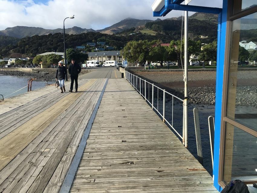
Communications
Akaroa Harbour Control, which operates only when ships are expected, listens on VHF channel 16 and uses channel 12 or 03 as its
working channel. As a backup in case of a systems fault with the remote network, the HM Office requires any vessel planning to
enter Akaroa Harbour to provide a bridge phone number so that a direct call may be made using that method if VHF contact
cannot be made. This number is to be provided via a standard email that will be notified to each ship by the ship’s agent with a
response required by the ship at least 24 hours prior to entry.

For provision of weather and nav warnings, the local station of the nationally operated Maritime Radio VHF network is available
locally through Akaroa Maritime Radio which listens on VHF 16 with working channel 68.

There is reasonable reception for mobile phones in the Harbour and around much of Banks Peninsula.

Weather conditions
Winds generally blow southeast or northwest (up or down) the Harbour. A SW wind change in the area can be violent and occur
quickly. During strong SW winds (outside the Harbour), there is a heavy cross sea and usually a heavy ground swell in the
Harbour entrance with violent and variable squalls caused by high steep land. SE swell conditions with SW winds cause the
worst conditions at the Heads. A heavy SE swell may make it advisable for the ship not to enter. With the exception of SE swells,
swells do not go further up the Harbour than 2.5NM. A wave rider buoy is located 9.5NM to the east of Steep Head Lt (Lat 43 o
45’S Long 173o 20’E) and is operated by NIWA. Information transmitted can be accessed from:
https://www.ecan.govt.nz/data/current-wave-data/ with a swell map available at:
https://niwa.co.nz/our-services/online-services/canterbury-wave-conditions

The anchorage areas are subject to strong gusts from the surrounding hills and to funneling of winds along its length. Sustained
winds in excess of 40 knots are common. The safety of vessels can be compromised by these winds and early departure from
the Harbour may be required.

Leisure and small commercial vessels
The Harbour is a busy and popular location for leisure users and small commercial vessel operators. These vessels may approach
cruise ships to allow a close-up view. Masters must be aware of the wash and turbulence created by their ship and its
manoeuvering equipment, and the negative impact this could have on the safety of small vessels.

Accidents, incidents and near miss
All accidents, incidents and near misses involving the navigation of the ship or its tenders must be reported to the
Harbourmaster. This report should be by phone at the time of the incident and in writing within 48 hours.
This reporting will allow the Harbourmaster to take any immediate actions required, and to follow up once a full report has been
completed.

Audits and reviews
A Harbourmaster staff member may undertake an audit onboard any vessel entering or departing Akaroa Harbour. This audit
may take the form of an on-bridge audit during the transit of the Harbour, or an audit of the records of the arrival/departure
while the vessel is at anchor. Review of documentation from the current and previous voyages may be undertaken when the
vessel is at anchor.

Port Security Plan
Akaroa Harbour has no operational Port Security Plan. Security is the responsibility of the Ship Security Officer. See also: Use of wharf
area for ship security; and Appendix 2 - Akaroa Wharf User Considerations.

Harbourmaster
Within this document the term Harbourmaster refers to the Regional Harbourmaster appointed by Environment Canterbury.
The term Harbourmaster staff member refers to the Harbourmaster or a staff member holding a suitable warrant who will be on
site at Akaroa.
-   Emergency contact with the Harbourmaster’s office is via Tel +64 3 328 9168 ext 1 for Duty Officer 24/7
-   To report any pollution incident: Tel 0800 76 55 88 or Tel +64 3 353 9007

                                                                 4
Limiting Requirements
Principles of Operation
Appendix 1, Akaroa Harbour Principles of Operation, is a code developed to raise awareness of community expectations for cruise ships
visiting Akaroa to maintain the unique environment that is Akaroa Harbour. The Principles of Operation have been developed in
conjunction with the local community and cruise operators and it is expected that all cruise vessel operations will be conducted in
accordance with this code.

Maximum vessel length
The maximum length of vessel to navigate within the Harbour is 345 metres LOA (length over all). Where a larger vessel wishes to
navigate within the Harbour the agent or operator should contact the Harbourmaster to establish if permission to enter may be
granted.

Permitted vessel length
The Regional Coastal Environment Plan allows vessels to enter the Harbour provided certain conditions related to seabed
disturbance are met. These provisions have been assessed as only allowing set numbers of vessels of certain sizes to enter the
Harbour on a per annum basis, with vessels in excess of these allowances requiring resource consent to enter. Information on
this, titled “Guidance to vessel masters and operators on the permissible anchoring of vessels at Akaroa Harbour” can be found
on Environment Canterbury’s website at https://www.ecan.govt.nz/document/download/?uri=3897180 and as Appendix 3 of
this document.

Arrival and departure speeds
A vessel’s speed during approach to and departure from the anchoring position must be kept to a minimum to prevent seabed
disturbance. This includes a maximum speed of 6 knots when UKC < 5m and 4 knots when UKC < 3m.

Under keel clearance
Vessel masters must ensure adequate under-keel clearance at all times the vessel is within the Harbour. A suitable allowance for
squat, heel, and swell must be made to maintain a minimum under keel clearance of 1.6 metres at all times.
A vessel master must make an assessment of the available depth of water for the duration of their passage plan from entry
into until departure from the Harbour. Reference should be made to Annual New Zealand Notices to Mariners 7 Under-Keel
Clearance. This information must be available on the bridge.

Visibility
Vessels must not enter into the Harbour or depart from an anchorage within the Harbour when the visibility is less than 0.5
nautical miles.

Navigation during the hours of darkness
Except as below, no vessel may enter into the Harbour or depart from any anchorage within the Harbour between the hours
of sunset and sunrise. These times are calculated for Akaroa Heads at the start of each season and made available to
relevant shipping agencies who will pass the information to ships as necessary.
This requirement shall not prevent the Harbourmaster or Harbourmaster staff member allowing a specific vessel permission to
navigate between the hours of sunset and sunrise where the circumstances of the case are deemed not to compromise the
overall safety of navigation.
This may mean that in the early or late stages of the cruise season, where days are shorter, a vessel may be able to make
arrangements to be allowed to enter the Harbour before sunrise. This could only occur if the weather and the visibility
conditions are sufficiently good (i.e. clear skies, calm winds and no fog, mist or rain). Should a vessel be delayed on departure the
Harbourmaster staff will likewise work to allow the vessel to depart after sunset.
Any allowance beyond the usual sunrise/sunset operating window would normally be limited to the period of civil twilight only. This flexible
working style represents the willingness of all parties to work together to provide a safe environment within the Harbour. This
working arrangement does not however allow vessels to schedule arrivals or departures outside of the usual sunrise to sunset
operating window.

Maximum wind speed
No vessel shall enter into the Harbour when the wind speed within the Harbour exceeds 30 knots. Such conditions will be
deemed to exist when informed by the Harbourmaster staff member that wind speed exceeds 30 knots, or in the absence of
the Harbourmaster staff member when the wind speed measured on the vessel by anemometer exceeds 30 knots, or the
master can reasonably expect wind speeds to be in excess of 30 knots based on previous experience (wind speed means
                                                                       5
average wind speed over a period of 60 seconds).

AIS equipment
A vessel within the Harbour must be fitted with an operational AIS system of Class A or B. This AIS system must remain switched
on and transmitting at all times. Tenders should be fitted with AIS and, where fitted, must have it switched on and transmitting
at all times whilst on the water.

Navigation with inoperative equipment
No vessel may navigate within the Harbour with any of the following equipment or systems inoperative
  1. Main propulsion system
  2. Steering equipment
  3. Manoeuvering equipment, bow or stern thrusters
  4. Any bridge navigational equipment, including but not limited to, chart plotters, radar, GPS, echo sounders, speed log.
  5. Any communications equipment including marine VHF radios on the bridge, internal communication systems
     between bridge, engine room, steering gear flat, fore deck, aft deck, boat decks and the point of passenger
     embarkation/ disembarkation.
Where any of the above equipment has been inoperative or suffered any type of failure within the previous 7 days the master
must inform the Harbourmaster in writing at least 24 hours prior to entering the Harbour.

Fuel oil transfers
The internal transfer of oil within the vessel whilst within the Harbour is prohibited.
Any transfer of fuel oil to a tender must be completed in an appropriate manner. It is preferable that a tender is removed
from the water or is in calm conditions during any transfer operation.
The use of a refueling system where the tender’s fuel tank filling pipe is sealed to the tank filling point, and the tank’s vent pipe is
connected to a hose back on board the ship, is recommended.

Hot work
No vessel shall undertake any work involving gas or electric welding, or cutting or grinding operations, without first seeking the
permission of the Harbourmaster. Permission for hot work operations will only be granted in exceptional circumstances.

Charts and publications
A vessel must have all necessary charts and pilot books pertaining to the Harbour. These charts and publications are to be in
accordance with SOLAS V and/or Maritime Rules Part 25.
Masters must ensure that all charts are corrected up to date from New Zealand Notices to Mariners. Some NZ charts are
not corrected within the Admiralty Notices to Mariners or other systems and must therefore be checked to ensure they are
up to date with New Zealand Notices to Mariners.

                                                                   6
Operational Requirements
Passage Plan
A vessel master must ensure a comprehensive passage plan is provided for the vessel’s entry, stay, and departure from the
Harbour. The plan must contain all pertinent information and all bridge team members must be briefed on the passage plan
prior to arrival at the Harbour. A pilotage card is provided in this document and may be used as part of a ships passage plan.
Passage plans must be kept on the vessel and provided to the Harbourmaster on request. A vessel must be able to make
available the arrival and departure passage plans for any visit to Akaroa undertaken within the previous four months. These
records may be electronic.

Weather forecasts
The master must ensure the latest weather forecasts for sea areas Conway and Rangitata, and the Akaroa Boating forecast are
available on the bridge. This information is available from:
  1. VHF - Akaroa Maritime Radio by scheduled broadcast
  2. Meteorological Office website https://www.metservice.com/national
  3. Continuous transmission on VHF channel 19

Manoeuvering & navigation equipment to be ready for immediate use
The master must ensure that a vessel’s manoeuvering and navigation equipment is ready for immediate use at all times the
vessel is within the harbour and its approaches.

Use of dynamic positioning and manoeuvering equipment
The use of thrusters, manoeuvering equipment or Dynamic Positioning equipment should be kept to a minimum once a vessel
has anchored. Effects of wash from this equipment can have a severe negative affect on the safety on vessels nearby. The use
of such equipment may also cause disturbance to the seafloor and degradation of water quality. As per the guidance document
(also Appendix 3 - Guidance to vessel masters and operators on the permissible anchoring of vessels at Akaroa Harbour
), from 01 November 2021 the use of any propulsion equipment, whether main or auxiliary, will only be allowed with the
explicit permission of the Harbourmaster.

Vessel tender operations
The operation of tenders from any vessel must be in compliance with the Canterbury Regional Council Navigation Safety Bylaws.
In particular, vessel wash and speed around the wharves and other vessels must be kept to a minimum. A copy of the chartlets
“Tender Movement to Pontoon(s) on Single Cruise Ship Days” and “Tender Movement to Pontoon(s) on Multiple Cruise Ship
Days” must be onboard each tender.
The Ship Security Officer, or person in charge of the tender and passenger embarkation/disembarkation must discuss the
tender operation and berthing plan with the Harbourmaster staff member prior to commencing operations.
Note: The operation of tenders during periods of strong winds may become hazardous. Masters must monitor the operation of
these tenders to ensure the safe embarkation/disembarkation of passengers at the wharf and ship.
Masters must always be aware that weather and/or sea conditions could require a vessel to depart at any time and that safe
and timely embarkation of passengers may not be possible. It is strongly recommended that operators have a contingency
plan for stranded passengers.
Tenders should be fitted with AIS, and, where fitted, must have it switched on and transmitting at all times whilst on the
water.

                                                                 7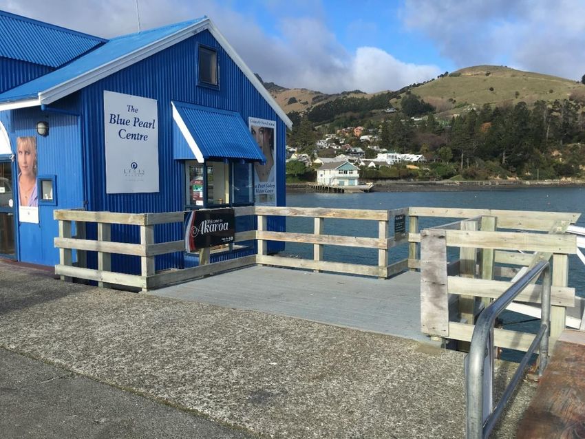
Anchorage
Vessels exceeding 8 metres draft and intending to anchor must remain outside the 10 metre depth
contour

 Anchorages for vessels over 8.0 metres draft
 No1:                                43o49.300’S                                   172o55.350’E

 Anchorages for vessels 8.0 metres draft or less
 No6:                                43o 48.740’S                                  172o55.830’E

 Anchorages for vessels 5.0 metres draft or less
 No7:                                43o48.540’S                                   172o56.560’E

 Anchorages for vessels 4.0 metres draft or less
 No4:                                43o48.390’S                                   172o57.020’E

NOTES: 1) Some vessel Masters have reported poor holding at times. It is recommended extra shackles of chain are laid.

Movement of multiple vessels
Where multiple vessels are wishing to manoeuvre at one time this must be undertaken in a coordinated manner. Vessel
masters must communicate with other vessels to ensure that only one vessel may be underway in the area north of Cape Three
Points (anchorage area and approaches) or to the south of Cape Three Points (general Harbour transit area) at any one time.
Effective communications will allow a second vessel to enter the Harbour once the first vessel is manoeuvering to its anchorage
position, or an anchored vessel to commence getting underway.

                                                                8
Emergency response procedures
All vessels must have comprehensive emergency response procedures for their vessel. As a minimum these must include:
Grounding
Collision with another vessel
Fire on vessel
Oil spill response
Tsunami
Earthquake
Medical emergency
Contact with obstruction
In the event of any incident the Harbourmaster may require a vessel(s) to remain at anchor within the Harbour for an extended
period. If an incident is serious this may require a vessel to remain anchored overnight. Vessel operators should be prepared for
this scenario.

Vessel information
The Harbourmaster staff member will collect information relating to the vessel on arrival and may board the vessel to audit the
passage plan and information made available to the bridge team.

Enforcement
Enforcement action will be taken against any master who fails to comply with these operating requirements. This may include
Infringement fines, prosecution and the requirement to carry a pilot on subsequent visits.

Use of wharf area for ship security
A Security area may be set-up on the wharf to allow the embarkation and disembarkation of passengers. This security area may
only be in place while a tender is alongside AND embarking or disembarking passengers. The wharf area must be available for
public use and berthing of other vessels at all other times. Exclusive use of a pontoon or space at the wharf is not available.
Please ensure ship staff are fully conversant with Appendix 2 - Akaroa Wharf User Considerations

The Security Officer on the wharf must hold a copy of this Navigation Safety Operating Requirements with them on the wharf.

Yacht races and sailing vessels
Akaroa Harbour is used by recreational sailing vessels. Tenders, as power driven vessels, are required to give way to sailing
vessels. When yacht races are being started near the yacht club (see tender movement diagrams on page 13 & 14),
tenders should keep well clear.

All vessels will be notified during arrival of the timing and location of any yacht race or event where the Harbourmaster’s
Office is aware of the event.

                                                                   9
Radio reporting
A vessel’s master must make the following ‘all ships’ calls on VHF channel 16 after gaining permission from the Harbourmaster staff
member to enter or depart.
  Inward:
     1. 5 minutes prior to passing abeam Akaroa Head
     2. on passing abeam Nine Fathom Point
     3. on completion of anchorage manoeuvre

  Outward:
     1. on commencement of weighing anchor
     2. once clear of Akaroa Harbour

  The ‘all ships’ call must state:
     1. Vessel name
     2. Location (as stated above)
     3. Inward or outward bound.

  Arrival procedure
  1. Agent notifies the Harbourmaster staff member of the planned arrivals for the prescribed day and discusses the
     order of vessel arrival and departure, and designated anchorage. A vessel movement schedule is compiled and
     approved by the Harbourmaster staff member.
  (The vessel movement schedule prescribes the order of vessel arrival and departure, approximate timings of these
     movements, and the designated anchorage for each vessel).
  2. Agent advises vessel(s) of the vessel movement schedule; and sends the Harbourmaster’s required standard email reminder of
     requirements – this will include the requirement for the ship to provide a bridge phone number as a back-up communications
     option.
  3. Vessel arrives at Harbour entrance at its allocated time. Akaroa Harbour Control will normally initiate communications
     by VHF Channel 16 approximately 1 hour prior to the vessel’s ETA at the entrance; and proceed with updated conditions
     within the Harbour and granting/declining/postponing, as appropriate, permission to enter. In the event of any systems
     fault with the VHF shore network, contact will be made using the provided ship’s bridge phone number.
  4. Vessel enters Harbour in accordance with these operating requirements
  5. Successive vessels may enter the Harbour once the vessel ahead has passed abeam of Nine Fathom Point and has
     made its “All ships” radio report on VHF channel 16.
  (This will allow timely vessel arrivals whilst allowing a vessel to anchor safely).

Departure procedures
  1. Vessel seeks permission from Akaroa Harbour Control to depart (Note: This may be granted in advance by
     Harbourmaster staff. If so, no call seeking permission at the time of departure will be required).
  2. Vessel calls “All ships” on VHF channel 16 and broadcasts that it is leaving.
  3. Vessel departs the anchorage and navigates in accordance with these operating requirements.
  4. Successive vessels may commence weighing anchor once the vessel ahead has passed abeam of Cape Three Points.

NOTE: Where a vessel is delayed on entry or departure, for whatever reason, all other vessels may depart at their
allocated times. Where a vessel is ready to depart the anchorage ahead of its allocated time the Harbourmaster staff
member may allow this movement to take place when he or she is satisfied it can be undertaken safely.

                                                                   10
AKAROA HARBOUR PILOTAGE CARD ARRIVAL
Check List
Vessel:
Date:
Draft: F A
Tides Akaroa: HW M
LW M
Expecting Weather:
UKC Calculation completed:
(Not less than 1.6m at LW)
Bridge equipment correct:
Ship’s pilot card complete:
(If first transit send pilot card to RHM)
Main engine and thrusters operational:
Any defects in ship’s equipment:
VHF channels 16/12/03:
Anchorage position:
ETA/ETD from anchorage:
Signed Ship’s Master:
Date: Time:
See instructions and information on next page.
11Additional important information for ARRIVAL
A vessel’s master must make the following ‘all ships’ call on VHF channel 16 after
gaining permission from Akaroa Harbour Control/Harbourmaster to enter.
Inward:
1. 5 mins prior to passing abeam Akaroa Head Once clear of Akaroa
Harbour
2. On passing abeam Nine Fathom Point
3. On completion of anchorage manoeuvre
The 'all ships' call must state:
• Vessel name
• Position
• Inward bound
To request permission to arrive before sunrise:
Contact Harbourmaster Duty officer on VHF 16 if no reply contact office via
cellphone as supplied by shipping agent.
If this is the 1st call into Akaroa Harbour the Regional Harbourmaster will require the inwards
pilotage card sent to harbourmaster@ecan.govt.nz and copied in lyt@iss-mckay.co.nz
12AKAROA HARBOUR PILOTAGE CARD DEPARTURE
Check List
Vessel:
Date:
Draft: F A
Tides Akaroa: HW M
LW M
Expecting Weather:
UKC Calculation completed:
(Not less than 1.6m at LW)
Bridge equipment correct:
Ship’s pilot card complete:
(If first transit send pilot card to RHM)
Main engine and thrusters operational:
Any defects in ship’s equipment:
VHF channels 16/12/03:
Anchorage position:
ETA/ETD from anchorage:
Signed Ship’s Master:
Date: Time:
Additional information: A vessel's Master calls Akaroa Harbour Control on VHF 16 to request
permission to depart - unless already given prior to departure by Akaroa Harbour Control
/Harbourmaster. A vessel's master must make the following 'all ships' calls on VHF channel 16 after
permission has been granted to depart:
1. On commencement of weighing anchor
If this is the 1st call into Akaroa Harbour
2. Once clear of Akaroa Harbour
the Regional Harbourmaster will require
The 'all ships' call must state: the departure pilotage card sent to
• Vessel name harbourmaster@ecan.govt.nz
• Position and copied in lvt@iss-mckay.co.nz
• Outward bound.
13Tender Movement to Pontoon(s) on Single Cruise Ship Days
A copy of this diagram must be available onboard each tender
To/from anchorage to pontoon: pass
north of buoy.
5 knot “no wake” zone
Marker Buoy
Note: Yacht race start area is inshore from the marker buoy.
Yacht Races and Sailing Vessels
Akaroa Harbour is used by recreational sailing vessels. Tenders, as power driven vessels, are required to
give way to sailing vessels. When yacht races are being started near the yacht club (see tender movement
diagrams above and on page 13), tenders should keep well clear.
14Tender Movement to Pontoon(s) on Multiple Cruise Ship Days
A copy of this diagram must be available onboard each tender
To/from anchorages as directed to
pontoon: pass north of buoy.
To/from anchorages as directed to
pontoon: pass south of buoy.
5 knot “no wake” zone
Marker Buoy
Note: Yacht race start area is inshore from the marker buoy.
Yacht Races and Sailing Vessels
Akaroa Harbour is used by recreational sailing vessels. Tenders, as power driven vessels, are required to
give way to sailing vessels. When yacht races are being started near the yacht club (see tender movement
diagrams above and on page 13), tenders should keep well clear.
15Photographs of Positions on Wharf
C
B
A
Photo near ‘A’ Looking at north pontoon and ramp
16Photo of boarding step on north pontoon (not for use by tender passengers)
This area must be left clear for commercial tour customers who queue against the timber railings.
Photo near ‘A’’ at the north pontoon gangway head. Note: uneven surface of wharf
17Photo near ’A’ showing area in front of BlackCat to be left clear at all times
Photo near ’A’ showing area for gazebo and cruise passenger queue along railings
18Photo taken at ‘C’ looking at south pontoon showing main berth (nearest side of pontoon)
Photo taken on south pontoon showing ramp and second berth
19Photo showing ramp to south pontoon. NOTE: no handrail at bottom of ramp
Photo taken at ‘B’ looking at top of south pontoon gangway showing suggested area for gazebo
20Photo taken at ‘B’ looking at top of south pontoon gangway Suggested area for passenger queue and area to be kept clear
Appendix 1 - Akaroa Harbour Principles of Operation
The aim of this Code is to raise awareness of community expectations for cruise ships visiting Akaroa to
maintain the unique environment that is Akaroa Harbour.

Introduction
The first inhabitants of the Akaroa Harbour basin were the navigators from East Polynesia, the ancestors of
today’s Māori. Forests covered much of Banks Peninsula and food resources made Te Pātaka a Rākaihautū -
the food store of Rākaihautū (the te reo Māori name for the Peninsula) - a place of favoured settlement.
Banks Peninsula was sighted by the British explorer, Captain James Cook, in 1770 who named it after Joseph
Banks, a gentleman and scientist on board the Endeavour. European and American sealers, whalers and flax
traders began to frequent Akaroa Harbour in the 1820s.

In the late 1830s, Captain Langlois promoted French colonisation. A small party of French and German
settlers arrived in Akaroa in August 1840 but by then, the Treaty of Waitangi had been signed and the
British had formally claimed sovereignty over all New Zealand. Until the middle of the 20th century, Akaroa
remained a relatively small fishing village, farm service centre and resort town.

Much of Akaroa remains largely unchanged due in part to the registration of the town as an Historic Area by
Heritage New Zealand in 1999. Tourism underpins the economy and visitors enjoy the town’s small-scale
atmosphere and beautiful setting. Akaroa’s population is around 640 residents. Visitors are welcome but
please respect resident’s privacy and show courtesy while in the town.

Entering the harbour, vessels will pass the Dan Rogers Marine Reserve on the right-hand side of the ship.
The Pōhatu Marine Reserve is located along the south east coast of the Peninsula. Marine Reserves protect
penguins, seal colonies and dense communities of sea creatures. The harbour is home to the endangered
Hector’s dolphins, and orca often visit the area.

Tourism NZ has developed the Tiaki Promise.
New Zealand is a special place, and everyone who lives, and travels, here has a responsibility to look after it.
The Tiaki Promise is a commitment to care for New Zealand while travelling.
By following the Tiaki Promise, you are making a commitment to New Zealand. To act as a guardian,
protecting and preserving our home.

Nau mai, haere mai ki Aotearoa, Welcome to New Zealand, the Land of the long white cloud.

While travelling in New Zealand I will:
Care for land, sea and nature, treading lightly and leaving no trace
Travel safely, showing care and consideration for all
Respect culture, travelling with an open heart and mind
Air discharges and pollutants
Any pollutants entering the environment can have adverse effects. Akaroa is a popular location for its
setting and clean environment including a marine reserve.

New Zealand is a signatory to MARPOL Annex VI which will be fully in force across NZ by early 2022

The use of exhaust gas scrubbers and/or compliant fuel is required when within the region’s waters.
Requirements for the changeover to a compliant fuel, or the use of closed loop scrubbers, is available in the
document annex and on the Environment Canterbury website at
https://www.ecan.govt.nz/document/download/?uri=3814161

Maintenance and wash down
    •   No external maintenance or cleaning shall be undertaken that may discharge debris, or any
        pollutants to water or to air. This will not exclude freshwater wash down of a ship’s hull and
        windows.
Noise
Noise may travel significant distances over water in certain conditions (calm or still days, nighttime).
Additionally, high frequency noises may adversely affect marine mammals. To assist in the minimization of
any possible adverse, or perceived adverse effects of noise cruise ship masters shall ensure the following:
    Ships Horn
    •   The ships horn is to be sounded only as a manoeuvering and warning signal as prescribed in the
        International Regulations for Preventing Collisions at Sea, or as an emergency signal.

    Announcements
    •   Minimize external announcements to those required for the safety of passengers or for quarantine
        purposes only.
    •   The volume of any external public address system is set to the minimum level for providing
        coverage onboard the vessel, which is consistent with the regulatory requirements governed by the
        international convention for the Safety of Life at Sea (SOLAS).

    Music
    •   Noise from music or display screens does not exceed 65 dBA Leq (15 min) measured and assessed
        at any point on land outside the Coastal Marine Area between 7 am and 10 pm on the same day

    Underwater noise
    •   Any minimisation of possible sources of high frequency noise below the waterline of the vessel.
        This would include the postponement of non-essential running of machinery, maintenance or other
        activities that may produce such noises.

Light
Lights from a vessel may have the effect of attracting and temporarily blinding bird life. Additionally, the
intensity of lights may affect some of the areas of Akaroa which are away from any form of natural lighting
(remote houses, baches etc). To minimise the possible effects of any lighting a cruise ship master shall
adopt the guidance provided by the Department of Conservation regarding vessel lighting and seabirds.
Large screen TV/displays:
    •   Minimise the brightness of any external video display screens to the minimum required
    •   Deck lights/ Birds
    •   Ensure that all extraneous deck lighting is switched off, whether by day or night, and that only deck,
        including open deck, and floodlighting required for the safety of passengers is displayed between
        sunset and sunrise.
Seabed disturbance
Disturbance of the seabed may cause environmental damage and can create silt plumes that affect water
quality and are unsightly in an area where the harbour and its marine life are a focus of attention. In order
to ensure minimal adverse effects a ships master shall meet the requirements of the Akaroa Harbour
Navigation Safety Operating Requirements covering anchorages, under keel clearance as well as arrival and
departure speeds.
Thrusters
• The use of thrusters should be kept to a minimum once a vessel has anchored except where
required for passenger transfer safety; provided that if used disturbance of the seabed be
minimised as much as possible.
• The use of thrusters for manoeuvering a vessel on arrival and departure will be in accordance with
ensuring safe passage of the vessel. Where possible, the use of thrusters should be kept to a
minimum and, where possible, not used.
• The use of thrusters to turn a vessel during a wind change should be avoided unless required for
the safety of the vessel or for passenger transfer safety.
Weather Conditions
The Akaroa Harbour area is subject to strong northwest and southerly winds. The NZ Meteorological service
provides forecast information on its website and via Maritime Radio. A vessel master should be fully
appraised of the expected conditions and ensure that:
• The ships safe operation, and the safe operation of its tenders, is possible in the forecast
conditions. Where the forecast conditions may affect a tender operation the ships master should be
satisfied that it is safe to proceed with the call.
• Cruise ships will abide by the Harbourmaster’s Directions at all times.
Tender operations
The Akaroa Harbour, and especially the area of water off the Akaroa township is used by recreational
vessels, commercial tourist operators, fishing and work vessels. The wide variety of use means that multiple
small vessels such as stand-up paddle boards, youth sailing dinghies, rowing dinghies and yacht races will be
encountered. The wharf is also used by these vessels and the cruise tenders will be sharing wharf space. A
vessel master must ensure:
Competence of operators
• The operators of the tenders, and their supporting crews, are competent to operate the tenders in
the vessel traffic, weather and other conditions on the day.
• The tender operators show courtesy to small craft such as youth sailing and rowing dinghies and
yachts racing by keeping well clear, at slow speed and minimal wake.
• The tender operators cooperate with, and show courtesy to other commercial operators in the
harbour
• Any on water incidents including near miss or impact with other vessel or users that occur are
immediately reported to the Harbourmaster
• Physical docking with the wharf is carried out in a way that ensures no damage occurs.
Emissions and discharges
Tenders are lifesaving appliances and maintenance is regulated by international safety authorities to a
very high standard and that no pollutants are discharged by a tender. Examples of such pollutants
include oily bilge water, black exhaust smoke.Wharf use The Akaroa Wharf is owned and operated for the community by Christchurch City Council. The wharf is a multi-user facility, and all users share the same space with no one operator having exclusive use of any area. To ensure the safe use of the wharf by all users, wharf operations guidance is included in the Navigation Safety Operating Requirements. This wharf operations guidance is provided following involvement of stakeholders. Environment Canterbury FAQ’s www.ecan.govt.nz/do-it-online/harbourmasters-office/commercial-shipping/cruise-ships/ Christchurch City Council FAQ’s http://ccc.govt.nz/the-council/future-projects/major-facilities/akaroa-wharf/
Appendix 2 - Akaroa Wharf User Considerations
                                                                                                     Co-operation over regulation

                                 Diagram A

                                                                                                                                                              Diagram B

On wharf congestion and obstruction

The public and all operators have access to all parts of the wharf and pontoons. To ensure unobstructed access for all users it is important that all operators work cooperatively to ensure fair use for all. Operators must consider
and adequately manage the following matters;
   • Queues of passengers across the front access of the Blue Pearl and/or Black Cat properties create issues with access. Cruise ship staff should ensure the access to these properties is kept clear at all times.
   • Obstructions to the flow of foot traffic onto, off and along the wharf can cause issues. The flow of people onto or off a pontoon, or along the wharf must not be obstructed by signs or equipment, or by activities such as
      queues, photography, or briefings. Obstruction issues can be more extensive on days with high passenger numbers.
   • A vessel operator may place one gazebo (shelter tent), not larger than 2 metres by 2 metres, when required. Furniture or multiple gazebos are not permissible. The gazebo must be placed in a position that does not
      cause an obstruction and must be quickly removed to allow access when requested. Suggested locations for gazebo’s are shown on the following diagrams.
   • The wharf and pontoons are used by local commercial operators, recreational boaties and the public throughout the day. All users must share the use of the wharf and pontoons and not obstruct others wishing to use
      the wharf or pontoon. Access ways to pontoons must not be blocked or fenced off.
   • Activities on the wharf include vehicle use for loading and unloading, emergency vehicle access and vessel refuelling vehicles. All signs, gazebos and other activities must allow access for these vehicles when
      requested.
   • Refuelling of vessels from mobile refuelling vehicles should be undertaken prior to the arrival of the first or after the departure of the last tender on a cruise ship day.
Akaroa Wharf Diagram Area A
Blue Pearl Premises
Suggested cruise passenger queueing area(s) Suggested gazebo location Keep this area clear Fishing vessel unloading/loading area
On wharf safety
• The safety of people is always paramount.
• Allow unobstructed movement of people onto, off and along the wharf
• Report any incidents or safety concerns to staff on the wharf or to the ship’s agent.
• Follow the instructions of staff on the wharf
• Be mindful that handrails are only fitted in certain locations.
• Do not refuel vessels at the wharf between arrival of the first and departure of the last cruise ship tender except via the diesel bowser.Akaroa Wharf Diagram Area B
Blue Pearl Premises
Black Cat Premises
Commercial tour passenger queueing Keep this area clear Suggested gazebo location (one gazebo only) Suggested cruise passenger queueing area Shallow area with ropes and obstructions
On wharf safety
• The safety of people is always paramount.
• Allow unobstructed movement of people onto, off and along the wharf
• Report any incidents or safety concerns to staff on the wharf or to the ship’s agent.
• Follow the instructions of staff on the wharf
• Be mindful that handrails are only fitted in certain locations.
• Do not refuel vessels at the wharf between arrival of the first and departure of the last cruise ship tender except via the diesel bowser.Appendix 3 - Guidance to vessel masters and operators on the permissible anchoring of vessels at Akaroa Harbour The Regional Coastal Environment Plan for the Canterbury Region (RCEP) and other legislation, provide for the ability of vessels to navigate in Akaroa Harbour. The RCEP allows, as a permitted activity, the disturbance of the seabed of up to 5m3 in any 12- month period. This note provides guidance on the current size of vessel, and number of anchoring visits, a vessel may make to Akaroa and be unlikely to breach the 5m3 rule. This guidance will be reviewed as further information is obtained. From 01 November 2021: Only two vessels greater than 100 m length between perpendiculars (LBP), may anchor in Akaroa Harbour at any one time, and No vessel of greater than 50,000 tonnes displacement may anchor within Akaroa Harbour without consent or scientific evidence of no adverse effects, and Allowable visits anchoring per 12-month period: i. Vessels < 100m LBP: multiple visits ii. Vessels >100m but < 150m LBP: 3 visits iii. Vessels >150m but < 200m LBP: 2 visits iv. Vessels >200m but < 260m LBP: 1 visit v. Vessels > 260m LBP: Consent or scientific evidence of no adverse effects required Note: when relying on this guidance, once anchored, a vessel may not utilise thrusters or propulsion machinery to assist passenger embarkation/disembarkation without the explicit permission from the Harbourmaster’s Office. Akaroa now has four anchorages available for vessels as shown below. Anchorage No1: 43o49.300’S 172o55.350’E for vessels over 8.0 metres draft Anchorage No6: 43o48.740’S 172o55.830’E for vessels 8.0 metres draft or less Anchorage No7: 43o48.540’S 172o56.560’E for vessels 5.0 m draft or less Anchorage No4: 43o48.390’S 172o57.020’E for vessels 4.0 metres draft or less Further information is available from the Environment Canterbury Harbourmaster’s Office here: https://www.ecan.govt.nz/do-it-online/harbourmasters-office/commercial- shipping/cruise-ships/
You can also read