Analysis Of The Willow Community Structure And Hydrarchy Succession Of Janghang Wetlands, A Ramsar Site In Korea
←
→
Page content transcription
If your browser does not render page correctly, please read the page content below
Analysis Of The Willow Community Structure And
Hydrarchy Succession Of Janghang Wetlands, A
Ramsar Site In Korea
Mi-yeon Na
Dongguk University - Seoul Campus: Dongguk University https://orcid.org/0000-0001-9266-3853
Choong-Hyeon Oh ( ecology@dongguk.edu )
Dongguk University - Seoul Campus: Dongguk University https://orcid.org/0000-0002-8512-9641
Research Article
Keywords: Salix nipponica, Willow, Riparian, vegetation, wetland succession, terrestrialization
Posted Date: March 9th, 2022
DOI: https://doi.org/10.21203/rs.3.rs-1369620/v1
License: This work is licensed under a Creative Commons Attribution 4.0 International License. Read
Full License
Page 1/24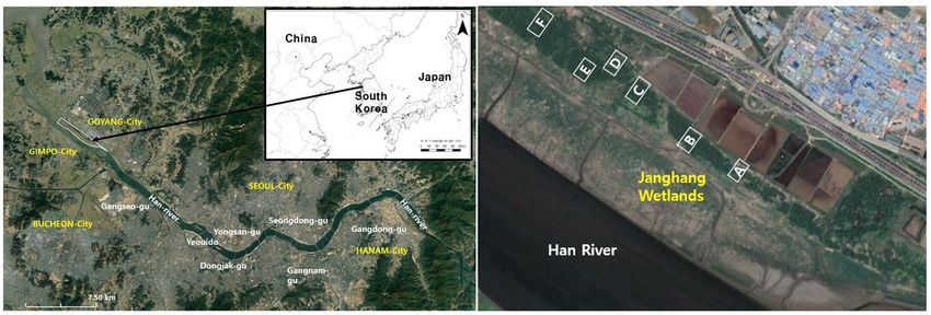
Abstract
Wetlands are gradually being lost due to climate change and excessive development. As a consequence, it
has become important to muster global cooperation to conserve wetlands. Janghang Wetland, registered as a
Ramsar Wetland in May 2021, is located at the estuary of the Han River and is a biodiverse wetland with a
dense willow tree community. However, problems with terrestrialization of Janghang Wetland have been
raised in several years. This study investigated hydrosere status and the causes through the analysis of its
plant community structure. It was found that the community for Salix koreensis- Salix nipponica takes up
more than 90% of the entire vegetation for willow. As a result of analyzing the MIV correlation between Salix
koreensis and Salix nipponica according to the distance from waterfront, Salix koreensis flourished more as it
moved away from the river. Comparison for the growth of Salix koreensis and Salix nipponica by quadrat,
showed that the Salix nipponica is affected by the tidal channel. Forest tree species such as Rosa
multiflora and Eleutherococcus sessiliflorus were found in the shrub layer. The amount of precipitation and
water level had been decreasing for the past 5 years. In the group dominated by Salix koreensis, the NaCl of
the soil was higher than the optimal level for tree growth, while the NaCl in the group dominated
by Salix nipponica, tended to be very close to '0'. In Janghang Wetland, Salix nipponica community is
gradually being replaced by Salix koreensis community and it causes by terrestrialization.

1. Introduction
Wetland is an area where freshwater, brackish water, or saltwater permanently or temporarily covers the soil,
and can be broadly divided into inland wetland and coastal wetland (RCS 2016, Kahlolo 2021). Riverside
wetland is important in terms of habitat and species biodiversity for organisms as a buffer zone for two
domains, the terrestrial ecosystem and aquatic ecosystem (R. Yapp 1922; Mitsch and Gosselink 2014; Lee et
al. 2019). Wetlands have been damaged or reduced in size by various land use developments (Niering 1994;
Keigo Nakamura 2006; Hong and Kim 2017), but their importance and ecological value started gaining
recognition from the end of the 20th century (Magnusson 2004; Nassauer 2004; Stewant B. Rood 2019; Edo
and Albrecht 2021). In addition, wetlands have been turned into dry areas by rapid climate change (Qiu et al.
1998; Mitsch WJ et al. 2013; Zaiyong Zhang et al. 2021), and wetland conservation has become an
international issue (EAAFP 2019; DAWE 2019; Dayathilake 2021). In the recently amended Wetland
Conservation Act of Korea, provisions on prevention of have been added (KRMGL 2021). Terrestrialization is
defined as a water zone gradually turning into land or being covered by vegetation because of the elevation of
riverbed (Yeo et al. 2009; Kim et al. 2014). Increase of vegetation in river may result in the loss of its
ecological function (Williams 1978; Gurnell 2014; Kim and Kim 2019; Kim et al. 2020).

The estuary of Han River is a brackish water area with no estuary bank and is an ecological transition zone
which occurs when freshwater meets saltwater. Located in this estuary, Janghang Wetland was designated
as a National Wetland Protection Area in 2006 and was registered as a Ramsar site in May 2021 (Ahn 2012;
Goyang-si 2019; RCS 2021). The willow community in Janghang Wetland provides food source, shelter, and
habitat for wildlife including migratory birds, mammals, fish, amphibians, and insects (Bang et al. 2011;
Markus-Michalczyk and Hanelt 2018), and provides citizens with waterfront views in the city (KME 2019).
Willow communities prevent soil erosion during flood (Brunet and Astin 1997; Markus.M and D. Hanelt 2018)

                                                   Page 2/24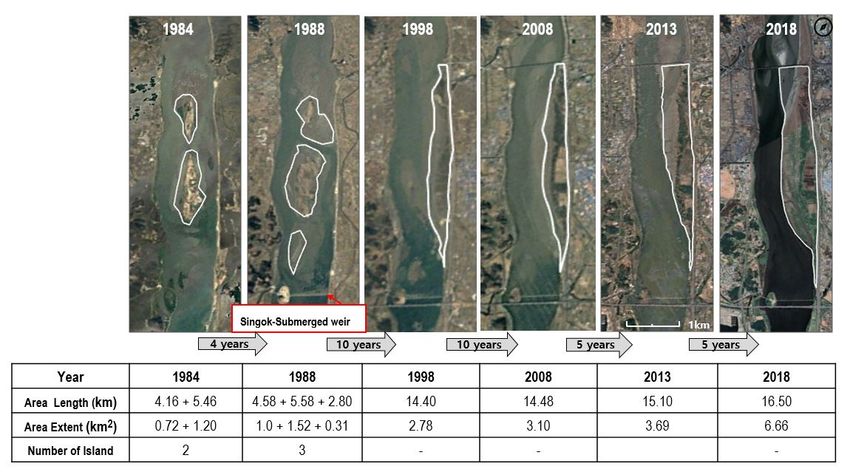
and absorb pollutants and heavy metals from water and soil (Vervaeke et al. 2003; Kuzovkina and Quigley
2005, KME 2014). Riparian trees help estimate the terrestrialization level of the river, calculate flooding
frequency of the river, and manage the water flow of the river (Woo 2001; Pike and Scatena 2010; Cliff R.
Hupp et al. 2016).

Terrestrialization in wetlands can be explained biologically by the process of hydrosere. This means gradually
changing from underwater to land communities, and hydrosere in wetlands has four forms; Reed-swamp
stage, Sedge-meadow stage, Woodland stage, and Forest stage (McGinnis 1918; Tayler 2019). In the
Woodland stage, wetland plants decrease, shrubs layer and understory layer begin to flourish, and in the
Forest stage, the canopy layer covers the entire vegetation. As for the vegetation of Janghang Wetland,
Sedge-meadow and Reed-swam stages exist sequentially along the waterfront, and willow community spread
out long in the direction of the river flow in the center of the wetland.

The representative tree species of Janghang Wetland are Salix nipponica and Salix koreensis. The species of
Salix are indicator of river and wetland vegetation. They are also pioneer species that thrive in lotic
environments and inhabit transition zones of wetlands and lands (Kuzovkina and Quigley 2005; Kim et al.
2013). The S. nipponica produces small, light seeds; develops multiple branches at the base of its stems; and
grows in moist areas with intermittent flooding (Lee et al. 2002; Asaeda 2019). The S. koreensis is a
deciduous broad-leaved tree as an indigenous of the Korea. It thrives around rivers or reservoirs and can grow
up 20m in height and 80cm in width (Lee 2003; Kim and Kim 2014).

Lee (2000) divided the distribution level of S. nipponica and S. koreensis into four stages according to the
height of the riverbed sediment (Lee et al. 2000). The first stage is when S. koreensis begin to inhabit the
wetland. The second stage is when S. koreensis move in and two species coexist as the terrestrialization
progresses. On the third stage, S. koreensis begin to dominate as S. nipponica gradually disappear. On the last
stage, most of the S. nipponica population disappears and S. koreensis take over the habitat which becomes
the climax forest (Lee et al. 2000). In addition, a study on the community characteristics of Salix spp. in the
Nanji Wetland Ecological Park of Han River found that S. nipponica tend to dominate areas with high flooding
frequency (Choi and Oh 2019), and S. koreensis tend to dominate areas with low flooding frequency or where
terrestrialization has taken place (Park et al 2015).

This study was conducted to manage and restore the willow colonies through the analysis of the Salix spp.
community structure of Janghang Wetland of the estuary of Han River.

2. Material And Method
2.1. Study Site
The Han River is located in the central part of the Korean Peninsula, which is 459㎞ long and 75.70m wide on
average. It encompasses 34,674㎢ of river basin, making up 23% of the land area of South Korea (KME 2014,
HFRCO 2021). The main course of Han-river is formed by the confluence of the Namhan River and the Bukhan
River near Paldang Dam. It flows through the center of Seoul and meets the Imjin River at its estuary (HRFCO
2019; Korea Ministry of Environment 2014). Janghang Wetland, located at the upstream of the estuary of Han

                                                     Page 3/24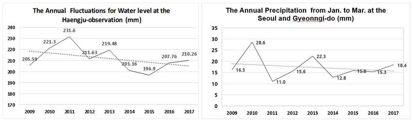
River, covers a broad span of multiple administrative districts, including Sinpyeong-dong, Deokyang-gu,
Goyang-si; Janghang-dong, Ilsandong-gu; and Songpo-dong, Ilsanseo-gu. Its latitude and longitude are 37˚ 38′
17″ N and 126˚ 45′ 47″ E. The wetland is approximately 7.6 km long and 0.6 km wide. The land area is 2.7㎢,
and its tidal flat covers 4.79㎢, making up the total area of 7.49㎢ (KME 2021).
According to a terrain map from the year 1978, Janghang Wetland consist of two alluvial islands (MOLIT
2009, KME 2021). After the construction of the Singok Submerged Weir in 1988, the flow rate of the
downstream area decreased and the amount of sediment increased, which resulted in the connection of two
islands (Lee and Hwang 2006). Afterwards, the land area has increased due to artificial factors such as the
construction of Jayu Road in 1990 and has become a sandbar (Goyang-si 2018).
The vegetation zone of Janghang Wetland is divided into waterside meadow, willow colony, and agricultural
land. The willow colony accounts for more than 20% of the total vegetation cover of Janghang Wetland
(Goyang-si 2019). The willow community has multiple vegetation layers such as herbaceous layer, shrub
layer, understory layer and canopy layer, providing habitat for various plants and animals (Johnson 1976;
Keddy 2010; Ahn et al. 2014; Stanek 2021). It is located on the border of Seoul and Goyang along the Han
River and serves as an ecological network, connecting each green corridor of the city. In addition, it provides
the four functions of provision, regulation, culture, and support services of ecosystem services. For instance, it
offers wetland for citizens to be used as a field site for education (Fisher et al. 2009; Bae et al. 2012; Oh 2016;
Schmutz 2018).
The documentary survey was conducted by referring to the historical data on the Han River development
project in Goyang area and analyzing the satellite pictures of the study area which are from the year 1984 to
2018(GEM 2018). The field survey was conducted a total of 10 times in the growing season, which was from
June 2018 to May 2019. Based on the satellite image, the location of the willow community was identified,
and study sites including farmland, eco trail, and tidal channel were selected along the flow of the Han River.
Then they were divided into six regions for survey, ranging from the letter A to F, at an interval of 200 to 300m.
Each survey region includes in 4–6 quadrats, and the survey points were indicated by their district names and
plot numbers. The total number of quadrats was 30 (Fig. 1).
2.2. Plant Community
2.2.1 Survey Method
Belt-Transect method and the Quadrat method were applied to determine the distance from the willow
community to the riverside of Han River. The vegetation of the community was surveyed by placing 10m ×
10m quadrat on each plot and dividing the vegetation into canopy, understory, and shrub layer. The height
and diameter at breast height (DBH) were measured for each tree of the canopy and understory layer, and the
height and crown width were measured for each tree of the shrub layer.
2.2.2 Data Analysis
The Importance Value (IV) of Curtis and McIntosh (1951) was calculated for each layer based on the
population and DBH to compare the dominance of species appearing at each quadrat. The IV was divided by
Page 4/242 after adding up the relative density and the relative coverage, and the Mean Importance Value (MIV) was
calculated by weighting each layer differently (Park 1985).
IV = (Relative Density + Relative Coverage) / 2
MIV= {(3 × IV in Canopy layer) + (2 × IV in Understory layer) + (1 × IV in Shrub layer)} / 6
Based on the MIV of each tree species in surveyed quadrats, the community was classified by TWINSPAN
(Two-way Indicator Species Analysis) (Hill 1979). The starting point of the willow community is 450m away
from the riverside of the Han River. Considering the characteristics of riverside wetland, the distance from
each quadrat to the Han River waterfront and the tidal channel as summarized in order to understand the
relationship between the water environment factors and the tree community structure in the quadrats.
Correlation analysis on the MIV of tree species in each survey area and the distance to the Han River
waterfront and the tidal channel were carried out. The distances were divided by 3 at a straight-line from the
Han River waterfront to the survey areas, and grouped into S1, S2 and S3. R-studio (4.0.4) was used for this
correlation analysis. Based on those groups, the tree community structure was analyzed according to the
distribution of MIV, population, DBH and height for salix spp. in each quadrat (Harcombe and Marks 1978).
2.3. Environmental Factors
2.3.1. Water level and Precipitation
The annual average water level and precipitation before the flowering season from 2009 to 2017 are shown
on the websites of the Korea Meteorological Administration and the Korea Water Environment Information
System (KMA 2018: KWAEIS 2018). The vegetation status according to the weather factors and water
environment was estimated based on the result.
2.3.2. Soil Property
For the analysis on soil property, soil sample for each willow community was collected three times in the
same quadrat. Using the soil analysis method of the Korea Forestry Promotion Institute, the soil particle size,
pH, organic and inorganic matter content of the collected samples were analyzed to figure out if they are
suitable for plant growth (Byeon 2009).
3. Results
3.1. Topography Variations
According to the satellite photo of 1984, Janghang Wetlands consisted of two islands; however, when the
Singok Underwater Weir was completed in 1988(GEM 2018), it was made up of three islands (Fig. 2). The
satellite photo of 1998 shows the sign of vegetation development, and the map from the year 2008 clearly
indicates a considerable growth of overall vegetation. By 2013, the river area near Ilsan Bridge decreased
significantly while the land area gradually increased. Since then, the land area has nearly doubled from 2013
(3.69 ㎢) to 2018 (6.66 ㎢) (Fig. 2). In a previous study by Ahn, the vegetation growth point was located 50 m
from the waterside before 2006(Ahn et al. 2012). That point where the willow community is located, was
Page 5/24around 150m until 2008. The distance was around 450m in 2018, being tripled in ten years. It has been found
that herbaceous plants such as reeds are inhabiting in the space between the waterside and the willow
community.
3.2. Plant Community
3.2.1. Community Classification
The population of Salix spp. that were identified from the investigation of 30 quadrats was 446 in total
including the individuals found in understory layer. There were 286 for S. nipponica, 148 for S. koreensis, and
4 for S. pseudolasiogyne. Based on the MIV of the trees found in each quadrat, the tree communities were
classified by applying the TWINSPAN method (Fig. 3). The indicator species of the first level was S. nipponica
and it was classified into two groups depending on the presence of the species. It is divided into two groups
for the 29 quadrats with S. nipponica and 1 quadrat, A13 without S. nipponica. The S. koreensis and S.
pseudolasiogyne. were found in the canopy layer of quadrat A13. The second indicator species was S.
koreensis, and it made appearance in the remaining 26 quadrats except for A11, A12, and B27. S. nipponica
and S. koreensis were found in common in those 26 quadrats, and it is assumed that most of the tree
communities in Janghang Wetlands are composed of two species.
3.2.2. Correlation Analysis for MIV and Distance from the
Riverside
In order to compare the water environment factors with growth characteristics of S. nipponica and S.
koreensis, the correlation analysis was conducted on the MIV of each tree species and the distance from the
riverside to the willow community (Table 1). The factors are two kinds, the distance from Han River and
distance from tidal channel to each quadrat (Fig. 4). Since the groundwater level of the survey district is
highly variable depending on the measurement point and season, the distance from the Han River waterfront
to the willow community was set as an analysis factor. The consequence of the correlation analysis showed
that the distance from the riverside to the willow community and the MIV of S. nipponica has a negative
correlation of 30.09% and that of S. koreensis has a positive correlation of 45.01%. The correlation between
MIV of S. nipponica and S. koreensis, and the distances from the willow community to the riverside and tidal
channel were 16.37% and 22.38%, respectively, indicating a rather low correlation. Since the location of tidal
channel has no regularity unlike the distance from the Han River as confirmed from aerial photograph in Fig.
4(NGII, 2018), the sum of the two waterfront distances was added to the analysis item. The correlation
between the MIV of S. nipponica and S. koreensis was high in the sum of the two types of waterfront
distances. The MIV of two species showed a strong negative correlation of 85.66%, indicating that S.
nipponica flourishes near the riverside while S. koreensis dominates as the distance from the riverside
increases. In addition, the density of S. koreensis in quadrat was inversely proportional to the density of S.
nipponica.
Page 6/24Table 1
Correlation Analysis for the MIV of salix spp. species for Each Community by Distance from Han River and
Tidal Channel to the Salix Community
Distance Distance from Distance for River MIV of MIV of
from Han Tidal channel + Tidal channel Salix Salix
River nipponica koreensis
Distance from 1
Han River
Distance from -0.30007 1
Tidal channel
Distance for River 0.83016 0.28271 1
+ Tidal channel
MIV of Salix -0.30098 -0.16377 -0.39837 1
nipponica
MIV of Salix 0.45014 0.22382 0.58345 -0.85665 1
koreensis
3.2.3. MIV of Salix spp. by Quadrats
Willow communities begin to emerge at 450m point away from the riverside. They were grouped into S1, S2,
and S3 depending on the distance from each quadrat to the riverside (Table 2). The average distance from the
waterfront was 483.00m for S1, 537.38m for S2, and 612.44m for S3. In the S1 group (450m-510m), which is
the closest group to the waterfront, there were 3 quadrats (B27, A11, A12) with the MIV of S. nipponica being
100.00%. There were 13 quadrats in the S2 group (511m ~ 570m). Among them, 2 quadrats where S.
pseudolasiogyne appeared were A13 and A14. The only quadrat with the MIV of S. nipponica being 0% was
A13. The MIV of S. koreensis was higher than the MIV of S. nipponica in 9 quadrats, and the MIV of two
species were both 50% in the remaining 4 quadrats. Among 9 quadrats in S3 (571m-660m), there were 8
quadrats where the MIV of S. koreensis was higher than that of S. nipponica The only remaining quadrat, C20,
was where the MIVs of both species were 50%. The MIV is a value obtained by adding up the dominance
value of tree species in canopy, understory, and shrub layer. Since S. nipponica dominates mostly understory
layers due to its growth nature, its MIV is relatively lower than that of S. koreensis. Although each of the layer
was given a weighting, the MIVs of S. nipponica and S. koreensis do not show a significant difference
because of the high population density of S. nipponica
Table 2 The MIV of Salix spp. for each community by distance to Han River and Tidal channel
Page 7/24Community Quadrat D.R *D.T S. nip. S. S. **R.mul. M. E. L.
for *DR Code (m) kor. pse. alb. ses. obt.
(m)
S1 B27 451 53 100.00 - - - - - -
450~510m D01 460 70 41.67 50.00 - 8.33 - - -
D02 470 90 40.00 60.00 - - - - -
A11 470 21 100.00 - - - - - -
D03 495 106 27.69 55.64 - - - 16.67 -
A12 503 30 100.00 - - - - - -
B28 505 28 40.00 60.00 - - - - -
E06 510 30 64.27 35.73 - - - - -
S2 D04 511 130 40.00 60.00 - - - - -
511~570m
A14 520 18 32.55 46.03 15.17 - - - 6.25
F24 520 50 40.00 60.00 - - - - -
A13 524 37 - 50.00 50.00 - - - -
D05 530 60 33.33 50.00 - 16.67 - - -
F21 531 70 33.33 50.00 - 16.67 - - -
B29 539 34 40.00 60.00 - - - - -
F25 540 20 47.02 46.00 - - 6.98 - -
C15 546 96 40.00 60.00 - - - - -
B30 547 59 56.65 43.35 - - - - -
C16 551 90 40.00 60.00 - - - - -
C18 561 88 50.00 50.00 - - - - -
C17 566 82 50.00 50.00 - - - - -
S3 F26 571 43 40.00 60.00 - - - - -
571~660m F22 580 10 40.00 60.00 - - - - -
E07 597 10 49.36 50.64 - - - - -
E08 607 15 40.00 60.00 - - - - -
E09 615 20 35.90 64.10 - -
C19 620 55 40.00 60.00 - - - - -
E10 631 23 40.64 42.70 - - 16.67 - -
Page 8/24C20 632 45 50.00 50.00 - - - - -
F23 660 38 40.00 60.00 - - - - -
* D.R.: Distance from Han River to survey plots, D.T.: Distance from Tidal channel to survey plots
**R.mul.: Rosa multiflora, M.alb.: Morus alba, E.ses.: Eleutherococcus sessiliflorus, L.obt.: Ligustrum
obtusifolium
In the S1 group, the MIV of S. nipponica tends to be high, which means that S. nipponica are dominant in the
group. In most quadrats of S2 and S3, which are located at a distance further than 511m from the Han River,
showed a high MIV of S. koreensis. It means that S. koreensis thrives and S. nipponica diminishes as it gets
further away from the waterside. In S2 and S3 group, where S. koreensis dominates, a large number of
withered S. nipponica individuals have been found. Through the MIV analysis, it is assumed that S. nipponica
and Salix koreensis will continue to compete in the canopy and understory layer.
In addition, comparative analysis on the MIV of S. nipponica and S. koreensis was conducted with species
shrub layer (Table 3). The MIV of S. koreensis was more than 50% higher in the quadrats where Rosa
multiflora, Eleutherococcus sessiliflorus were found. And it was found that the MIV of S. koreensis was
relatively low in the quadrats and the MIV of S. nipponica tended to be high where Morus alba, which is well
adapted to wet environment.
Table 3
The MIV of quadrats with new species in shrub layers
Species in Shrub Layer R. Mul. M. alb. E. ses. L. obt
Quadrat Code D01 D05 F21 E10 F25 D03 A14
MIV of S. nip. 41.67 33.33 33.33 40.64 47.02 27.69 32.55
MIV of S. kor. 50.00 50.00 50.00 42.70 46.00 55.64 46.03
3.2.4. Growth Condition for Salix spp. per Quadrats
The averages number of individuals, DBH and height for each quadrat in S1, S2, and S3 group were
calculated (Table 4). Based on the outcome, it is possible to estimate the growth status and environmental
characteristics of each group (Kang 2019). The average distance to the riverside from each quadrat of the
group was 483m for the S1 group, 537m for the S2 group, and 612m for the S3 group. The average distance
to the tidal channel was 54m for the S1 group, 64m for the S2 group, and 29m for the S3 group. The tidal
channel exists everywhere around the Han River, regardless of the distance from the group to the riverside.
The average distance from the tidal channel to the S3 group, which is located far from the riverside, was the
lowest among all groups at 29m. Consequently, it has been confirmed that the average number of S.
nipponica per quadrat was high in the S3 group. And the average number and DBH of S. koreensis per
quadrat were high in that group. In the case of S. nipponica, the average number of individuals and height per
quadrat was high but the DBH was relatively low in the S3 group. The high number of individuals and low
Page 9/24DBH of S. nipponica in S3 may attribute to the fact that S. nipponica continue to reproduce under the
influence of the surrounding tidal channel but are unable to sustain itself for long.
Table 4 The average population, DBH and height of S. nipponica and S. koreensis per quadrat
Group Num. of *A.D.R *A.D.T. Total Per Quadrat
Quadrats Population
Average of Average of
Population DBH
S. S. nip. S. kor. S. nip. S. S
kor. kor. .nip.
S1 8 483.00 53.50 27 77 3.38 9.63 19.78 17.96
S2 13 536.69 64.15 73 97 5.62 7.46 19.34 18.27
S3 9 612.44 28.78 46 97 5.11 10.78 20.85 15.53
*A.D.R.: Average Distance from Han River, A.D.T.: Average Distance from the Tidal Channel
3.3. Environmental Factors
3.3.1. Water level and Precipitation
Change in water level at the Han River estuary measured by Haengju Bridge Water Observatory and monthly
precipitation data provided by Korea Meteorological Administration were comparatively analyzed by year (Fig.
5). The growth of willows in low arctic Tundra may be subjected to drought stress due to the increase of
temperature and the decrease of precipitation in summer (Magdalena 2020). The growth of willows in
temperate zone is affected more by the precipitation from January to March than the average annual
precipitation (Lee et al. 2012; Kim et al. 2013; Choi and Jun 2019; Kim and Kim 2020). The water level by each
year of 10 years up until the previous year of the survey was compared to each other. It was 231.60mm in
2011 and 210.26mm in 2017, decreasing by more than 20mm (Table 5). The amount of precipitation between
January and March decreased gradually to 11mm in 2011, went up drastically to 22.30mm in 2013, and
gradually decreased again to 15.30mm. The water level, which controls water balance, groundwater flow, and
salt water movement, also affects vegetation. The soil moisture and salinity can be estimated from the
vegetation cover condition (Taree 1992; Horton 2001; Yali Chi and Jingli Shao 2005). The longer the drought
period or the lower the amount of precipitation, the more difficult it becomes for wetland-adapted tree species
to grow, and the easier it becomes for xeric adapted invasive tree species to grow (Annemarie G. Garssen et al.
2014). As the water level and precipitation continued to decrease for 5 years from 2014 (Table 5), it is
considered that S. nipponica, which had steadily grown from the shrub layer to the understory layer, has
declined in the number, while S. koreensis has rapidly grown to the canopy layer.
Page 10/24Table 5
The annual average water level change by each year at Seoul and Goyang-si
Year 2009 2010 2011 2012 2013 2014 2015 2016 2017
Water (mm)
Water level 205.59 221.30 231.60 211.63 219.48 201.16 196.90 207.76 210.26
(Goyang-si
Deokyang-
gu)
Precipitation 16.30 28.60 11.00 15.60 22.30 12.80 15.80 15.30 18.40
of *Jan.-
Mar. month
(Seoul-
Gyeonngi )
3.3.2. Soil Properties
In order to understand the chemical characteristics of the soil for each group of quadrats of Janghang
Wetlands, they were divided into the S1 group, which is dominated by S. nipponica, and the S2 and S3 group,
both of which are dominated by S. koreensis. And then comparative analysis on multiple soil properties
including pH, organic content, nitrogen content, available phosphoric acid, and cation exchange capacity
(CEC) was carried out (Table 6). The soil particle size of each quadrat was either silt or silt loam, with silt
content ranging from 70 to 83%, sand content ranging from 17 to 23%, and clay content ranging from 3.7 to
8.5%. Organic content, total nitrogen content, available phosphoric acid, electrical conductivity (EC) and NaCl
content of the soil either exceeded or failed to reach the standard level for tree growth. Among them, total
nitrogen content and available phosphoric acid did not display differentiated numerical value.
Organic content of wetland soil normally increases in inverse proportion to flooding frequency (Craft 1988).
However, in the case of Janghang Wetlands, its overall organic content seems to be low due to the influence
of the tidal channel. There was no particular difference in the organic content among each group of S1, S2,
and S3, so it is estimated that the organic content does not significantly affect the growth of S. nipponica and
S. koreensis. Electrical conductivity (EC) is an indicator that comprehensively displays the concentration of
ions and salt in the soil, and can estimate the salinity in an indirect way (Byeon 2009). While the EC of the
standard level for tree growth is less than 0.4 (dS/m-1), it ranged from 0.33 to 0.73 (dS/m-1) in S1 group and
1.20 to 1.58 (dS/m-1) in S2 and S3 group. The values of S2 and S3 group were 2.5 times higher than the
value of S1 group. The NaCl content ranged from 0.006–0.009% in B27, B28, and E06 quadrat of S1 group
where S. nipponica is dominant. This is much lower than the standard value of 0.05% for tree growth. On the
other hand, among the five quadrats dominated by S. koreensis, the NaCl content of F21, F22, and F25
quadrat NaCl content was higher than the standard level for tree growth. The NaCl content of F23 and F24
quadrat were 0.043% and 0.049% respectively, which were close to the maximum value (0.05%) for tree
growth. The outcome of soil analysis may indicate that salt accumulates more as it gets further away from
the riverside, which in turn affects the growth of S. nipponica.
Table 6. The comparison for soil analysis as to classification groups by distance from riverside
Page 11/24Properties for *Suitable Group for S1 Group for S2 & S3
Soil Analysis standard
(unit) value for tree B27 B28 E06 F21 F22 F23 F24 F25
growth
pH 5.5 6.5 6.6 6.6 6.9 6.5 6.0 6.7 6.3 6.2
* O.M.(%) ≥ 3.0 1.24 1.65 1.84 0.53 0.58 1.21 0.58 0.73
T.N.(%) ≥ 0.25 0.114 0.134 0.149 0.049 0.079 0.108 0.078 0.089
*A.P.(mg/kg-1) 60a result of analyzing the tree community structure based on the biological hydrarchy succession mentioned in
the introduction, Janghang Wetlands has already transitioned from the Woodland stage to the last stage, the
Forest stage. As to the 4th stage of the terrestrialization process in the salix spp. community (Lee et al. 2012),
the willow community in Janghang Wetlands seems to be in the 3rd stage of terrestrialization, in which S.
nipponica decline and S. koreensis flourish. Although the importance and value of the willow community was
acknowledged, there was a lack of literature review which are comparable to the willow community in the
Janghang Wetlands of the past. The time of terrestrialization was estimated by checking the change in the
area of sedimentation and vegetation through satellite images.
The increase of the size of willow community in Janghang Wetlands is confirmed through the annual
topographical change, and the study on the characteristics of S. nipponica and S. koreensis in Janghang
Wetlands can be a useful baseline data. In addition, in the investigation of the herbaceous layer in the willow
community, many halophytes such as Carex scabrifolia, Bolboschoenus planiculmis, Calamagrostis epigeios,
Phacelurus latifolius and Plantago lanceolate were found, so the salinity in the soil could be an important
factor (Vandersande 2001). Accumulation of salt in soil after evaporation of moisture in the soil can cause
fatal damage to sensitive plants (Kratsch 2008; Paudel et al.2018; Feng 2020; Haraguchi & Sakaki 2020;
Chapman 2021; Martina Baaij et al. 2021).
In particular, long-term monitoring of change in salinity and water level can predict the potential population
decline of plant species at an early stage (M. Adeleye et al. 2021), so intensive management of target species
can prevent from extinction. For the efficient use by human, the physiological characteristics of Salix spp. tree
were artificially improved to match the surroundings (Hangs R. D. 2011), and an appropriate environment is
managed to preserve native species (Korea Water Resources Association, 2019). Flow rates, aquatic
topographical mechanisms, water quality and ecological conditions are key indicators of maintaining optimal
wetland habitat (Swanson et al. 2017; Mukherjee 2019). This study, like the latter, focuses on the growth of S.
nipponica, a representative wetland plant of the floodplain, and has significance in evaluating the wetland
environment.
5. Conclusion
According to the analysis of the community structure of the Salix community in Janghang Wetlands, two tree
species, Salix nipponica and Salix koreensis, are constantly competing to expand the vegetation area. The
dead trees of S. nipponica in understory layer, which grows naturally in intermittent flooded areas, are found,
and the rapid growth of S. koreensis in canopy layer is a stage in which terrestrialization has already taken
place. The cause of terrestrialization in this study was estimated to change the sedimentary area and to be
decreased in precipitation and water level due to climate change. The water level gradually decreased due to
the increase in the sedimentary area and the decrease in precipitation, and it is believed that the initial
Woodland stage progressed rapidly to the Forest stage in recent years. In order to maintain the value of
Janghang Wetlands, it is necessary to focus on improving the problems related to the moisture content in the
soil and the water environment. Changes in soil moisture content and groundwater level can be roughly
estimated by referring to the growth status of S. nipponica in Janghang Wetlands. Further studies on the
distribution of dead trees and physiological characteristics of salt tolerance and drought stress of S.
nipponica should be conducted. S. nipponica thrive in riverside floodplains, which can act as an ecological
Page 13/24indicator of the environmental condition of wetlands. In order to conserve wetlands, both detailed research on
the tree community structure and monitoring of flora and vegetation of wetlands need to be conducted.
Declarations
Supplementary Information
The online version contains supplementary material available at https://10.8888/EPOPS202202161ND
Acknowledgements
First of all, the authors would like to acknowledge to Mr. Doo-won Cha, Mr. Seung-joon Lee, Ms. Eun-hye Lee,
Dr. Je-sun Bae, Dr. Mi-hu Kim, Dr. Dong-hyo Kim, Dr. Su-hong Ban, Dr. Jin-won Kim, Dr. Si-yang Wei, and all
members of Institute of Ecosystem Service. We also acknowledge all editors for their helpful comments on
this paper. Special thanks to: Dr. Young-seok Lim (Kangwon National University), Dr. Byung-Mook Weon
(Sungkyunkwan University), Dr. Dong-wook Han (PGA Eco. Diversity Institute), public officials and citizens
who protect Janghang Wetlands.
Author’s Contributions
Mi-yeon Na performed material preparation, data collection, analysis of all data, and writing this manuscript.
Choong-hyeon Oh led the conceptualization of this study and contributed to the review and provided valuable
comments, and approved it.
Funding
The authors declare that no funds, grants, or other support were received during the preparation of this
manuscript.
Data Availability
The datasets generated during analyzed during are available from the corresponding author on reasonable
request.
Code Availability Not Applicable
Conflicts of interest Not Applicable
Consent to Participate Not Applicable
Ethics Approval Not Applicable
References
1. Ahn HK, Kim SN, Chung SJ, Lee DJ & Lee SH (2012) Topographical change of sandbar and vegetation
settlement in Jang-Hang wetlands for Han River Estuary Wetlands Restoration. Journal of Wetlands
Page 14/24Research,14(2), 277-288
2. Ahn HK, Kim SN, Chung SJ, Lee DJ & Lee SH (2012) Topographical change of sandbar and vegetation
settlement in Jang-Hang wetlands for Han River Estuary Wetlands Restoration. Korean Wetlands Society
14(2):277-288
3. Ahn HK, Lee DJ, Kim SN (2014) The Classification of Instream Habitats for Ecological River. Restoration
Ecology and Resilient Infrastructure. 1(2):82-93, https://doi.org/10.17820/eri.2014.1.2.082
4. Akira Haraguchi & Masato Sakaki (2020) Spatial Distribution of Sea Salt Deposition in a Coastal Pinus
thunbergii Forest Water, 12, (1) : 2682, https://doi.org/10.3390/w12102682
5. Annemarie G. Garssen, Jos T. A. Verhoeven, Merel B. Soons (2014) Effects of climate-induced increases
in summer drought on riparian plant pecies: a meta-analysis, https://doi.org/10.1111/fwb.12328
6. Asaeda Takashi, Senavirathna MD, Krishna LV, Yoshida Naoya (2019) Impact of regulated water levels on
willows (Salix subfragilis) at a flood-control dam, and the use of hydrogen peroxide as an indicator of
environmental stress. Ecological Engineering 127:96-102, https://doi.org/10.1016/j.ecoleng.2018.10.028
7. Bae MK, Park CS, Oh CH (2012) Aesthetic Landscape Assessment Based on Landscape Units in the Han
River Riparian Area. 40(1): 43~56
8. Bang SW, Shin YC & Kim AS (2011) Acessement of Economic Value for Janghang Wetlands in Han-River
estuary. Korea Environmental Policy and Administration Society. pp. 3-15
9. Bao Chao, FANG Chuanglin (2008) Impact of Water Resources Exploitation and Utilization on Eco-
environment in Arid Area: Progr ess and Prospect. Progress in Geography ROGRESS Vol.27, No.3
10. Barry Taylor (2019) Early Holocene wetland succession at Lake Flixton (UK) and its implications for
Mesolithic settlement. https://doi.org/10.1007/s00334-019-00714-9
11. Brendan Fisher, Kerry Turner, Matthew Zylstra, Roy Brouwer, Rudolf De Groot, Stephen Farber et al. (2008)
Ecosystem Services and Economic Theory: Integration for Policy-Relevant Research. Ecological
Applications 18(8):2050-2067
12. Byeon, JG (2009) Method of soil survey and analysis data analysis of landscaping tree plantations. Kor.
Landscaping Tree Asso. pp. 35-41 (In Korean)
13. Carmen G. Franks, David W. Pearce, Stewart B. Rood (2019) A prescription for drug-free rivers: uptake of
pharmaceuticals by a widespread streamside willow. Environmental Management (2019) 63:136–147,
https://doi.org/10.1007/s00267-018-1120-8
14. Choi JC & Jun KW (2019) An Analysis of Channel Landforming Characteristics at the Estuary of the
Gagokcheon Due to Change in a Riverine Environment. Crisisonomy 15(8):97-106,
https://doi.org/10.14251/crisisonomy.2019.15.8.97
15. Choi JH, Jun KW (2019) An Analysis of Channel Landforming Characteristics at the Estuary of the
Gagokcheon Due to Change in a Riverine Environment Crisisonomy 15(8): 97-106
16. Choi JK, Choi MK, Lee GY (2017) The Process of River Landscape for 10years in Tan-chun Ecological
Landscape Reserve. J. Korean Env. Res. Tech. 20(6):107-115
17. Choi JW and Oh CH (2019) A Study on the community structure of Salix spp. forests in Han-river estuary.
Master´s dissertation, Univ. of Donngguk, Seoul. p.95 (In Korean)
Page 15/2418. Cliff R. Hupp, Simon Dufour, Gudrun Bornette (2016) Vegetation as a Tool in the Interpretation of Fluvial
Geomorphic Processes and Landforms / Chap.10 of ‘Tools in fluvial Geomorphology pp.225-226,
https://doi.org/10.1002/0470868333.ch10
19. Craft, C. B., Broome, S. W., Seneca, E. D. (1988) Nitrogen, phosphorus and organic carbon pools in natural
and transplanted marsh soils 11(4):272-280
20. Curtis, J. T. and McIntosh, R. P. (1951) An Upland Forest Continuum in the Prairie-Forest Border Region of
Wisconsin. Ecology. 32(3):476-496
21. D.D.T.L. Dayathilake, E. Lokupitiya, V.P.I.S. Wijeratne (2021) Estimation of Soil Carbon Stocks of Urban
Freshwater Wetlands in the Colombo Ramsar Wetland City and their Potential Role in Climate Change
Mitigation
22. Daniel Grasel, Eduardo Luis Hettwer Giehl, Florian Wittmann & Joao Andre Jarenkow (2021) Patterns of
Plant Diversity and Composition in Wetlands Across a Subtropical Landscape: Comparisons Among
Ponds, Streambanks and Riverbanks Wetlands vol.41(90)
23. DAWE-Department of Agriculture, Water, and the Environment (2019) Wetlands and climate change.
https://www.environment.gov.au/system/files/resources/233f0c0b-450d-4f6a-839c-
cbb90b7d2761/files/wetlands-climate-change.pdf.
24. Dowon Lee (2001) Landscape Ecology pp.15-17(In Korean)
25. EAAFP- East Asian-Austrasian Flyway Partnership (2019) Martin Spray’s Presentation for EAAFP 10th
Anniversary -Conference on the Conservation of Migratory Waterbirds and their habitats in the EAAF.
26. Edo, J. & Albrecht, E. (2021) Threats to Niger-Delta Wetlands: A Case Study of Apoi Creek Forest. Open J.
Ecology, 11(2): 136-147
27. G. Mathias Kondolf & Herve Riegay (2016) Tools in Fluvial Geomophology Second Edition P.215-216
28. GEM-Google Earth Map (2018) The Satellite Photography on the Google Earth programe from 1984 to
2018
29. Goyang City Hall (2018) Report of Ecological Monitoring Janghang Wetlands in Han-River Estuary by
Citizens p.20 (In Korean)
30. Gurnell, A. (2014) Plants as river system engineers: Further comments, Earth Surface Processes and
Landforms, Volume40, Issue.1 pp. 135-137, https://doi.org/10.1002/esp.3671
31. Han DU, Yoo JW, Yoo YH, Lee EJ & Park SG (2010) Aboveground Primary Productivity of Salix nipponica
and Secondary Productivity of Sesarma dehaani at Janghang Wetland in Han -River estuary. Korea J.
Limnol. 43(2) : 298-310 (Summery in English)
32. Hangs, R. D., Schoenau J. J., Van Rees K. C. and J Steppuhn H. (2011) Examining the salt tolerance of
willow (Salix spp.) bioenergy species for use on salt-affected agricultural lands, Canadian. Plant Sci.
91(2): 506-517
33. Harcombe, P.A. and P.H. Marks (1978) Tree Diameter Distribution and Replacement Processes in
Southeast Texas Forests. For. sci. 24(2): 153-166.
34. Heidi Kratsch, Shawn Olsen, Larry Rupp, Grant Cardon & Rick Heflebower (2008) Soil Salinity and
Ornamental Plant Selection HG/Landscaping
Page 16/2435. Heike Markus-Michalczyk & Dieter Hanelt (2018) Willow species vary in elevational occurrence and
morphological characteristics on the tidal freshwater section of the Elbe estuary, In Ecohydrology &
Hydrobiology January.19(1):14-23, https://doi.org/10.1016/j.ecohyd.2018.08.006
36. Heike Markus-Michalczyk & Dieter Hanelt (2019) Willow species vary in elevational occurrence and
morphological characteristics on the tidal freshwater section of the Elbe estuary Ecohydrology &
Hydrobiology 19: 14-23
37. Helen Anastasia McGinnis (1918) The contrast between climax and seral types of vegetation pp.4-9
38. Henrik Sjöman, Anders Busse Nielsen, Stephan Pauleit & Mats Olsson (2010) Habitat Studies Identifying
Potential Trees for Urban Paved Environments: A Case Study from Qinling Mt., China. Arboriculture &
Urban Forestry, 36(6): 261-271
39. Hill, M.O. (1979) TWINSPAN - a FORTRAN Program for Arranging Multivariate Data in an Ordered Two-
way Table by Classification of the Individuals and Attributes. Ecology and Systematics, Cornel Univ.,
Ithaca, New York, p.99
40. Hong MG & Kim JG (2017) An analysis of trends in wetland function assessments and further
suggestions Journal of Wetlands Research 19(1): 1-15(Summery in English)
41. Horton, J.L., Kolb, T.E. & Hart, S.C. (2001) Physiological response to groundwater depth varies among
species and with river flow regulation. Ecological Applications, 11 (4):1046-1059,
https://doi.org/10.2307/3061011
42. HRFCO-Han River Flood Control Office (2022) Information for Han River on the website
43. Hwang SY, Lee SH & Park JM (2007) Influence of Floods and Tides on the Bed Changes in the Han River
Estuary, Korea Society of Civil Engineers, 10: 4149-4152
44. Hyo Seop Woo (2001) River Hydraulics pp.768-770 (In Korean)
45. Jang S.H., Oh G.D. and Oh J.H. (2016) Han River Underwater-dam and Estuary Wetlands (In Korean)
46. Jenna E. Stanek, Shannon E. Mcneil, Diane Tracy, John R. Stanek, Jeffrey A. Manning, Murrelet D.
Halterman (2021) Western Yellow‐Billed Cuckoo Nest‐Site Selection and Success in Restored and Natural
Riparian Forests. The Journal of Wildlife Management 85(4):782–793,
https://doi.org/10.1002/jwmg.22020
47. Joe UJ and Song GS (2011) Will the ecological river restoration project be able to restore the river
ecosystem. Korean River Association . River and Culture 7 (1) :92-96 (In Korean)
48. Johnson, M. F., Thorne C. R., Castro J. M., Kondolf G. M., Mazzacano C. S., Rood S. B. & Westbrook C.
(2020) Biomic river restoration: A new focus for river management. River Research and Applications
49. Jung SH, Kim AR, Seol JW, Lim BS & Lee CS (2018) Characteristics and Reference Information of
Riparian Vegetation for Realizing Ecological Restoration Classified by Reach of the River in Korea.
Journal of Korean Society on Water Environment, 34(5): 447-461,
https://doi.org/10.15681/KSWE.2018.34.5.44
50. Jung, H. R. and Kim, K.H. (2012) Management Practices on Salix Communities by Water Level Control in
Namgang-Dam. Kor. Soc. Civ. Eng. 2012(10) pp.2754-2757(Summery in English)
51. Kahlolo N., Mapeshoane B.E., Chatanga P., Seleteng-Kose L. & Marake M.V. (2021) Vegetation and
Associated Environmental Conditions of the High-altitude Letšeng-la-Letsie Palustrine Wetland, a Ramsar
Page 17/24Site in Lesotho, Wetlands, 41 (6):1-15, https://doi.org/10.1007/s13157-021-01476-9
52. K. Mukherjee (2019) Hydromorphological Appraisal of Wetlands: Diara Region of Malda District, West
Bengal Ph.D. Thesis Visva-Bharati University, Santiniketan, India
53. Kang HM, Park SG, Kim JS, Lee SC & Cho SH (2019) Vegetation Characteristics of Ridge in the
Seonunsan Provincial Park. Korean J. Environ. Ecol. 33(1): 75-85 (In Korean with English abstract)
54. Kaoru Niyama (2010) Coexistence of Salix species in seasonally flooded habitat (11th chapter) Ecology
of Riparian Forests in Japan
55. Katembe W.J, Ungar I.A and Mitchell J.P. (1998) Effect of salinity on germination and seedling growth of
two Atriplex species (Chenopodiaceae). Ann Bot 82: pp.167-175
56. Kaustuv Mukherjee (2020) Wetland habitat stability assessment in hydro-geomorphological (HGM) and
surface water availability (SWA) conditions in a lower Gangetic floodplain region of Eastern India
57. Keigo Nakamura, Klement Tockner & Kunihiko Amano (2006) River and Wetland Restoration: Lessons
from Japan. BioScience. 56(5):419-429
58. Kim DH, Kim Won, Kim ES, Ock GY, Jang CL, Choi MK & Cho KH (2020) Applications and Perspectives of
Fluvial Biogeomorphology in the Stream Management of South Korea. Ecology and Resilient
Infrastructure.7 (1):1-14, https://doi.org/10.17820/eri.2020.7.1.001
59. Kim HJ, Shin BK & You YH (2011) A Study on the Planning of Riparian Forest in Flood Plain Korea. Kor. J.
Env. Eco. 25(2):189~210.
60. Kim Jin-seok and Kim Tae-yeong (2014) Woody Plants of Korea Peninsula, Korea, 228-231 (In Korean)
61. Kim KH & Jung HR (2013) A Study on withering of Salix nipponica Communities in Namgang-Dam
Reservoir. Kor. Soc. Eng. pp.1821-1825 (In Korean)
62. Kim SB, Kim JY, Im RY, Do YN, Park SH, Joo GJ & Kim GY (2013) Correlation Analysis between Phenology
of Salix spp. and Meteorological Factors. Journal of Environmental Science International 22(12); pp.
1633~1641 (Summery in English)
63. Kim Won & Kim Sinae (2019) Analysis of the riparian vegetation expansion in middle size rivers in Korea.
J. Korea Water Resour. Assoc.52(S-2): pp.875-885, https://doi.org/10.3741/JKWRA.2019.52. S-2.875
64. KME-Korea Ministry of Environment (2014) Conservation Plan Research for Wetlands Protection Area in
Han-River Estuary P.105 (In Korean)
65. KME-Korea Ministry of Environment (2021) Report on the results of 2020 Monitoring the Ecosystem of
Wetland Protected Areas at the Estuary of the Han River. pp.100-104 (In Korean)
66. Koo HK (2001) An Ana1ysis for the Soil Characteristics of Wangdeungjae Wetland in Jiri Mountains,
Korea. Journal of Geography Vol. 37, pp. 1-18
67. Korea Water Resources Association (2019) Ecologic Stream Engineering pp.306-307 (In Korean)
68. KMA-Korea Meteorological Administration (2018) https://www.kma.go.kr/eng/index.jsp
69. KWEIS-Korea Water Environment Information System (2018) http://water.nier.go.kr/web
70. KRMGL-Korean Reliable Ministry of Government Legislation (2021) Article 5th of the Wetland
Conservation Act in Wetland Conservation Law (In Korean)
Page 18/2471. Kuzovkina, Y. A. & Quigley, M. F. (2005) Willows beyond wetlands: uses of Salix L. species for
environmental projects, Water Air Soil Poll., 162, pp.183-204
72. Lee JM, Cho YH & Kim HW (2018) Study on the Flora and Vegetation Changes in the Riparian Zones of
Han River Watershed. The Korea Res. Tech. 22(2):13-30, https://doi.org/10.13087/kosert.2019.22.2.13
ISSN 1229-3032
73. Lee PH, Son SG, Kim CS & Oh KH (2000) Population Dynamics of Salix nipponic8 and S. koreensis during
the Riverbed Sedimentation in the Wetland of the Nam-River. Kor. Wetlands (2) pp. 95-107 (Summery in
English)
74. Lee PH, Son SG, Kim CS & Oh KH (2002) Growth Characteristics of Salix nipponica Kor. J. Wetl. Vol.4
No.2 pp.1-11 (Summery in English)
75. Lee SY, Hong YS, Jung HM, Lee EP, Kim EJ, Park JH, Jung YH, Cho KT & You YH (2019) Vegetation of
Jangdo wetland conserved area in South Korea and its management strategy. Korean J. Environ.
Biol. 37(1):109-118, https://doi.org/10.11626/KJEB.2019.37.1.109
76. Lee YJ & Lee SH (2008) A Study on the Status of Wetland and the Utilization of the Han River Estuary.
pp.17-21(In Korean)
77. Lee, Tchang-bok (2003) Colored Flora of Korea I, Korea, 165-171 (In Korean)
78. Liao, J., Song, H., Tang, D., & Zhang, S. (2019) Sexually differential tolerance to water deficiency of Salix
paraplesia-A female-biased alpine willow. Ecol. Evol. 9, pp. 8450-8464,
https://doi.org/10.1002/ece3.5175
79. Liu Zheng, Shuangshuang Chen, Lihua Xie, Zhuchou Lu, Mingying Liu, Xiaojiao Han et al. (2018)
Overexpression of cysteine protease gene from Salix matsudana enhances salt tolerance in transgenic
Arabidopsis Environmental and Experimental Botany 147: pp.53-62,
https://doi.org/10.1016/j.envexpbot.2017.11.008
80. Magdalena Opała-Owczarek, Piotr Owczarek, Ewa Lupikasza, Stephane Boudreau & Krzysztof Migala
(2020) Influence of climatic conditions on growth rings of Salix uva-ursi Pursh from the southeastern
shore of Hudson Bay, Subarctic Canada. Arctic, Antarctic, and Alpine Research (P)1523-0430; (E)1938-
4246
81. Magnusson (2004) The changing perception of the wetlands in and around Kristinastad, Sweden. New
York academy of science pp.324-327
82. Mansour T., Nazila, K. & Hossein, S. (2012) The effects of salt stress and prime on germination
improvement and seedling growth of Calotropis procera L. seeds. J. Ecol. Field Biol. 35(2): pp. 73-78
83. Matthew W. Vandersande, Edward P. Glenn & James L. Walworth (2001) Tolerance of five riparian plants
from the lower Colorado River to salinity drought and inundation Journal of Arid Environments (2001) 49:
147}159, https://doi.org/10.1006/jare.2001.0839
84. Michelle T. Casanova & Margaret A. Brock (2000) How do depth, duration and frequency of flooding
influence the establishment of wetland plant communities? Plant Ecology 147: 237–250
85. Mitsch WJ, Bernal B, Nahlik AM, Mander U, Zhang L, Anderson CJ, Jorgensen SE & Brix H (2013)
Wetlands, carbon, and climate change. Landscape Ecology 28:583–597,
https://doi.org/10.1007/s10980-012-9758-8
Page 19/2486. Nassauer, J.I (2004). Monitoring the success of metropolitan wetlands restorations: Cultural
sustainability and ecological function. Wetlands, 24(4): pp.756-765.
87. Nature and Ecology Policy Division, Ministry of Environment of Korea (2021) Ramsar Information Sheet-
Janghang Wetlands, https://rsis.ramsar.org/ris/2448
88. NGII-National Geographic Information Institute (2018) The Aerial Photography for survey in 1974 and
2018
89. Niu, G. and Rodriguez, D.S. (2006) Relative Salt Tolerance of Selected Herbaceous Perennials and
Groundcovers. Scientia Horticulturae 110:352-358.
90. Oh CH, Kim DH, Oh CG, Lee YH & Park EH (2016) Introduction of Payment for Ecosystem Services of
Deoksan Provincial Park in Chungcheongnam-do Literature and Environment 15(2):97-124
91. Opała-Owczarek, M., Lupikasza E., Owczarek P., Migala K. & Boudreau S. (2020) Influence of climatic
conditions on growth rings of Salix uva-ursi Pursh from the southeastern shore of Hudson Bay, Subarctic
Canada. Journal of Arctic, Antarctic, and Alpine Research 52(1),
https://doi.org/10.1080/15230430.2020.1722397
92. Orloci, L. (1978) Multivariate Analysis in Vegetation Research (2nd Edition). Junk Publishing, The Hague,
p.468
93. Paikho Rho & Chang-Hee Lee (2014) Spatial Distribution and Temporal Variation of Estuarine Wetlands
by Estuary Type Journal of the Korean Geographical Society 49(3): 321-338
94. Park HC, Lee GG & Lee JH (2015) Analysis of Vegetation Recovery Trend in Abandoned Paddy Wetland−
Focused on Flora and Vegetation Changes of Clear Zone Surrounding Pyeongtaek K-55 Air Force Base.K
SCE Journal of Civil Engineering 19(4): pp. 864-872
95. Park IH (1985) A Study on Forest Structure and Biomass in Baegwoonsan Natural Ecosystem. Seoul
Natinal Univ. Graduate School Dissertation for the Degree of Doctor of Philosophy, p.42
96. Park SG & Choi SH (2020) Data Analysis of Plant Community Structure and Diversity pp.75-79 (In
Korean)
97. Park SY, Yi YM, Yoon HS & Sung KJ (2012) Retention properties of organic matters and nutrients in
wetland soils and coastal sediments (Summery in English)
98. Paul A. Keddy (2013) Wetlands Ecology – Principles and consevation-2th ED. pp.2-3
99. Pike, Andrew S. & Scatena, Frederick N. (2010) Riparian indicators of flow frequency in a tropical
montane stream network In,Journal of Hydrology 2010 382(1):72-87
100. Qiu Hanxue, Wang Bingchen & B Adams (1998) Water resources exploitation and sustaining
development in arid area. Marine Geology & Quaternary
101. R.H. Yapp. (1922) The Concept of Habitat. Journal of Ecology. Vol. 10(1): pp. 1-17
102. RCS-Ramsar Convention Secretariat (2016) The Fourth Ramsar strategic Plan 2016–2024,
https://ramsar.org/document/the-fourth-ramsar-strategic-plan-2016-2024
103. RCS-Ramsar Convention Secretariat (2021) Republic of Korea adds Janghang Wetland to the List,
https://ramsar.org/news/republic-of-korea-adds-janghang-wetland-to-the-list
104. Rene-Claude Brunet & K. Brian Astin (1997) Spatio-temporal variations in sediment nutrient levels: The
River Adour Landscape Ecology volume 12, pp. 171–184
Page 20/24105. Riparian Vegetation Expansion Due to the Change of Rainfall Pattern and Water Level in the River (2020)
Ecology and Resilient Infrastructure (2020) 7(4): 238-247, https://doi.org/10.17820/eri.2020.7.4.238
106. River Restoration Research Center (2006) River Restoration Casebook p.25 (In Korean)
107. S. Swanson, D. Kozlowski, R. Hall, D. Heggem, J. Lin (2017) Riparian proper functioning condition
assessment to improve watershed management for water quality J. Soil Water Conserv., 72 (2), pp. 168-
182
108. Sakio, Hitoshi Tamura, Toshikazu (2010) Ecology of Riparian Forests in Japan Disturbance, Life History,
and Regeneration p.324
109. Shishir Paudel, Amanda Milleville & Loretta L Battaglia (2018) Responses of Native and Invasive Floating
Aquatic Plant Communities to Salinity and Desiccation Stress in the Southeastern US Coastal Floodplain
Forests. Estuaries and Coasts, 41(8), https://doi.org/10.1007/s12237-018-0419-2
110. Salinas, M.J.& Guirado, J. (2002) Riparian plant restoration in summer-dry riverbeds of southeastern
Spain. Restoration Ecology.10(4):695-702), https://doi.org/10.1046/j.1526-100X.2002.01050.x
111. Seoul-city Hall (2019) The study of general planning for Ramsar Wetlands Ban-islands at Han-river pp.84-
85 (In Korean)
112. Shuang Feng, Hongwei SunAimin Zhou, Yuanyuan Bu and Shenkui Liu, Hongping Ma, Xin Zhang,
Shurong Ma (2020) Sexual Differences in Physiological and Transcriptional Responses to Salinity Stress
of Salix linearistipularis Front. Plant Sci. 11:517962, https://doi.org/10.1002/ece3.5175
113. Stefan SchmutzJan, Sendzimir (2018) Riverine Ecosystem Management: Science for Governing Towards
a Sustainable Future Aquatic Ecology Series, https://doi.org/10.1007/978-3-319-73250-3
114. Steven, W. Carothers, R. Roy Johnson & Stewart W. Aitchison (1974) Population Structure and Social
Organization of Southwestern Riparian Birds. American Zoologist,14(1):97-108
115. Willam A. Niering (1994) Wetlands –National Audubon Society Nature Guides pp.31-42
116. William, J. Mitsch and James, G. Gosselink (2014) Wetlands 15th ED. 3-4p, pp.27-28
117. Won Kim, Sinae Kim (2019) Analysis of Riparian Vegetation Expansion in middle size rivers in Korea, J.
Korea Water Resour. Assoc. 52(S-2) pp. 875-885, https://doi.org/10.3741/JKWRA.2019.52.S-2.875
118. Yali Cui & Jingli Shao (2005) The Role of Ground Water in Arid/Semiarid Ecosystems, Northwest China
Ground Water. 43(4) pp. 471-477, https://doi.org/10.1111/j.1745-6584.2005.0063.x
119. Yeo CG, Im JH, Lee SO & Song JW (2009) Numerical Study of Preventive Hydraulic Structure for
Landforming, Korea Water Resources Association pp.718-722
120. Yeo JK, Park JH, Koo YB, Kim HC & Shin HN (2010) Effects of NaCl Concentration on the Growth of
Native Willow Species Collected in a Coastal Reclaimed Land (Summery in English)
121. Yulia A, Kuzovkina & Martin F. Quigey (2005) Willows Beyond Wetlands Uses of Salix. L. Species for
Environmental Project, Water Air and Soil Pollution: MAR 2005, 162 1-4; 183-204,
https://doi.org/10.1007/s11270-005-6272-5
122. Zaiyong Zhang, Wenke Wang, Chengcheng Gong, Ming Zhao, Harrie-Jan Hendricks Franssen & Philip
Brunner (2021) Salix psammophila afforestations can cause a decline of the water table, prevent
groundwater recharge and reduce effective infiltration
Page 21/24Figures
Figure 1
The survey sites (A, B, C, D, E, F) and location on the map for Janghang wetlands
Figure 2
The satellite photograph and area size of the Janghang Wetlands from 1984 to 2018
Page 22/24Figure 3
The dendrogram of classification by TWINSPAN for tree community in Janghang Wetlands
*S. nip.: Salix nipponica, S. kor.: Salix koreensis, S. pse.: Salix pseudolasiogyne
Figure 4
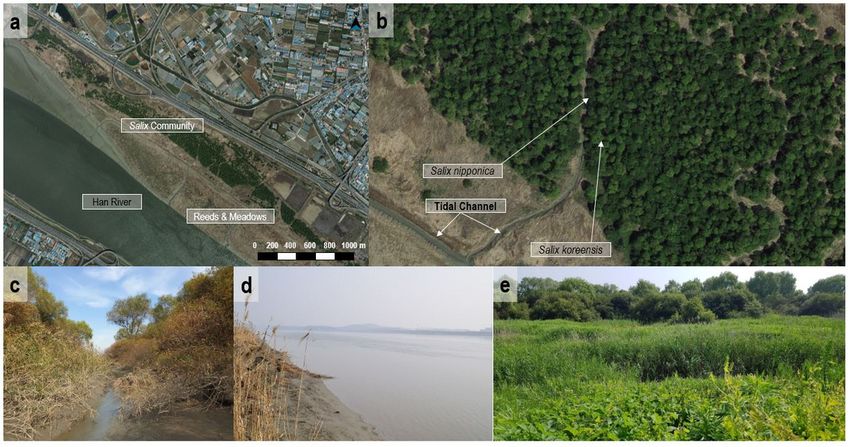
Salix community and Tidal Channel. a Aerial photograph of Salix community and Han River, b Distribution for
Salix nipponica and Salix koreensis, c Tidal Channel in Salix Community, d Han River and Riverside, e Reeds
and Meadows in Janghang Wetlands
Page 23/24Figure 5
The change of water level and Precipitation for annual average by each year at Seoul-si and Goyang-si
Page 24/24You can also read