Approaching Skyscape Archaeology: A Note on Method and Fieldwork for the Case Study of Pompeii - Groma
←
→
Page content transcription
If your browser does not render page correctly, please read the page content below
Ilaria Cristofaro, Michele Silani

Approaching Skyscape Archaeology: A Note
on Method and Fieldwork for the Case Study
of Pompeii

    The urban layout of Pompeii presents several orientations, possibly due to an uneven bare ground pla-
    teau. However, its main east-west axes have the same orientation of Herculaneum ones, suggesting that
    not only geomorphological constrains can explain the urban plan. Starting from a hypothesis by Nissen
    (1906), the method of skyscape archaeology was applied to Pompeii urban grid and temples, testing di-
    gital models with fieldwork measurements. The results show that the main east-west axes aligned with
    the rising summer solstice sun above the local horizon. Furthermore, the Doric Temple was orientated
    with the sunset on the same day of the year, suggesting an intentional design in the foundation ritual.

1.Introduction: Aims and Rationale of Skyscape Archaeology

The discipline of archaeoastronomy is more than one century old. This field of
study is part of a wider etiquette called cultural astronomy, the study of the re-
lationships between cultures and the sky. Though, due to its hybrid nature, for a
long time archaeoastronomy could not find its proper place within academia, at
least in Europe.1 In the past, archaeoastronomers, often professional astronomers,
archaeologists, anthropologists or architects, have been debating between two ex-
treme methodological tendencies in order to prove celestial alignments: one side
rigorous statistics was applied on a large number of similar sites as possible, on the
other side the evidence was drawn upon records from anthropological history and
archaeology.2 This led to the so-called “green” and “brown” archaeoastronomy as
reflected in the colour of two monographic volumes.3 Certainly, a midway method
between the two approaches became evident. In the last decade, with the work by
Liz Henty and Fabio Silva, archaeoastronomy was referred to as skyscape archaeo-
logy, in the attempt to fully affirm its identity within the discipline of archaeology,
by starting from the material records towards a historically contextualised inter-

1     Campion 2015.
2     Ruggles 2011.
3     Ruggles 2011, 2.

                                                         GROMA | documenting archaeology
                                                                            ISSN: 2531-6672 | Vol. 5-2020
                                                                       DOI: 10.12977/groma33 | pp. 1-22
                                                                 Published on: 06/03/2021 | Section: Note
                                                                  License: CC BY-NC-ND 4.0 International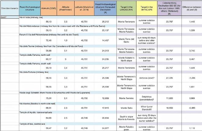
pretation, and to be placed alongside landscape and maritime archaeology.4 The
aim of archaeoastronomy, or skyscape archaeology, is to contextualise an archae-
ological site within the wider cosmos by reconstructing the ancient celestial vault
and, possibly, its cultural value. Any potentially significant directions in archaeolo-
gical structures, for instance the main axis, is geometrically extended and projected
on the celestial sphere just above the profile of the local horizon: at that sightline
horizon astronomy questions which celestial events might have been seen looking
in that given direction as defined by the archaeological structure. Astronomical
orientations are not just ones that reflect cardinal directions, as it often has been
taken for granted.5 Important celestial orientations are many on the horizon: they
can range from solstitial alignments, following the rising and setting positions of
the sun across the year, lunar standstills which are similar to solar solstices but have
a longer period of 18.6 years, significant rising and setting of brightest stars and
planets, and to Milky Way alignments.6 Celestial bodies are the world time keepers,
as well as the main tool for human groups to navigate within a wider landscape: in
ancient times the sky was a fundamental point of reference for ordering time and
space. More than practical uses, the celestial dome was also a realm of divinities and
of the sacred. For instance, in many cases solar light was manipulated within the
darkness of sacred architectures: precisely orientated structures channelled sunlight
to illuminate statues or paintings at a specific time of the year with predictable
hierophanies.7 In conclusion, by analysing monuments orientations the research
aim is to find evidence of intentionality in order to establish if human groups built
their architectonic environment in accordance to specific celestial patterns. This
complex issue of intentionality will be dealt with further on in this paper. The aim
of this contribution is to provide a brief methodological note on the application of
skyscape archaeology techniques to an ancient site by presenting a recent analysis
in regard to the urban grid of Pompeii and its temples.8

2. The Site: Pompeii and its Urban Layout

Any skyscape archaeological investigation should start from an understanding of
the cultural and environmental features specific to the site, since the choice of
observational points constrains the identification of alignments and interpretations.

4    Henty 2014, 13; Silva 2015.
5    Sommella 1988, 231; De Caro 1992, 81, n. 69.
6    Ruggles 2014a, 463-470; Connolly 2016, 13-15.
7    Ruggles 2014b, 380-381; Incerti 2001.
8    This preliminary note is related to the beginning of a doctoral project on the orientation of
    temples and urban grids in ancient Campania, from the 8th to the 3th century BC. The project is
    carried out at Capys Laboratory at Università degli Studi della Campania Luigi Vanvitelli under
    the coordination of Prof. Carlo Rescigno, with the collaboration of Dr. Frank Prendergast and
    Dr. Georg Zotti.

Ilaria Cristofaro, Michele Silani                                                                2
Establishing which directions might have been considered potentially meaningful
is the preliminary step of this approach.9 In regard to a temple, the main axis in
either direction is usually taken as the most important line,10 but the diverging
orientation of associated altars can be meaningful as well. For an urban orthogonal
settlement, directions of main streets should additionally be considered, if no hints
are given otherwise.11 In the case of Pompeii, the urban plan presents several orien-
tations, often not orthogonal to each other (fig. 1), and it is not clear if any dia-
chronic orientation reassessments happened.12 Indeed, detailed knowledge of the
development of the city from its Archaic foundation at the end of the 7th century
or beginning of the 6th century BC until the Hellenistic restructuration is doubtful
and still in debate.13 One of the reasons is that the Archaic findings and structures
remains too scattered to get a full understanding of the Archaic urban grid.14 The
differences in height above sea level of the plateau, with Via Stabiana following
the contours of a natural canyon, should be considered as a constraint causing the

                                                                                        Figure 1. Pompeii’s
                                                                                             plan with the
                                                                                          urban references
                                                                                          mentioned in the
                                                                                             text (adapted
                                                                                        from Morichi et al.
                                                                                          2018 by Michele
                                                                                                    Silani).

9 Ruggles 2014b, 376.
10 Boutsikas 2007-2008; Pernigotti 2019.
11 González-García et al. 2019.
12 Bonghi Jovino 2011, 10.
13 Bonghi Jovino 2011; Giglio 2016.
14 Avagliano 2018.

3                                                                    GROMA 5 - 2020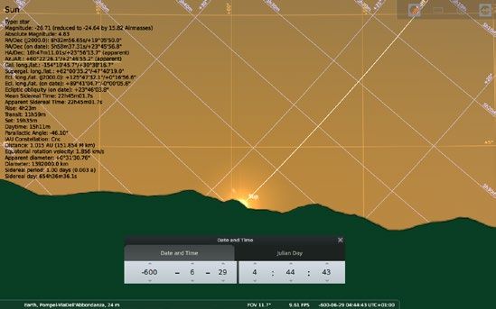
layout to diverge from a geometrical form, if ever one was intended.15 Thus, scho-
                       lars have explained orientation as defined by geomorphological causes;16 however,
                       the independence of Pompeii east-west axes in respect to altimetric conditions is
                       confirmed by its comparison with Herculaneum, whose decumani, or east-west
                       axes, have the same azimuths as in Pompeii i.e. c. 60°/240°.
                       In questioning the diachronic layout of Pompei, it may be useful to test astrono-
                       mical hypotheses of orientation. In the Sarno Valley, a strong Etruscan characteri-
                       sation of the social indigenous communities preceded the foundation of Pompeii,17
                       and the Etrusca Disciplina of setting boundaries was based on the observation of the
                       sky, at least as far as the Latin legacy can testimony.18 At the beginning of the 20th
                       century, Heinrich Nissen proposed that Via di Nola pointed towards the rising sun
                       at summer solstice, but mentioning an error evident by the fact that the south side

Figure 2. Horizon
profile as seen from
Pompeii looking East   of the street was not illuminated.19 Stefano De Caro suggested, instead, that the
(PeakFinder 2020).
                       same road was intended to point towards Monte Torrenone (fig. 2), a triangular
                       shape mountain on the north-eastern side and location of Sarno river springs.20 In
                       order to test these and other hypotheses, a digital landscape and skyscape model
                       were first reconstructed; secondly, site fieldwork was undertaken in order to check
                       the accuracy of the virtual reconstructions; third, some considerations on a possible
                       interpretation are suggested. Due to the doubts regarding how the urban grid was
                       planned and developed, it was necessary to progress by enabling more possibilities,
                       testing all directions and starting from the most central routes, including Via di
                       Mercurio, Via delle Terme, Via della Fortuna, Via Marina, Via di Nola, Via dell’Ab-
                       bondanza, and so on (fig. 4).21 In particular, for the specific task of questioning
                       Nissen’s hypothesis, the focus is on the North-East horizon where Via dell’Abbon-

                       15   Holappa and Viitanen 2011, 182.
                       16   Holappa and Viitanen 2011, 182; Giglio 2016.
                       17   Cristofani 2009.
                       18   Briquel 2008, 44.
                       19   Nissen 1906, 105-107.
                       20   De Caro 1992, 82.
                       21   Ruggles 2014b, 376; Ruggles 2014a, 414.

                       Ilaria Cristofaro, Michele Silani                                                   4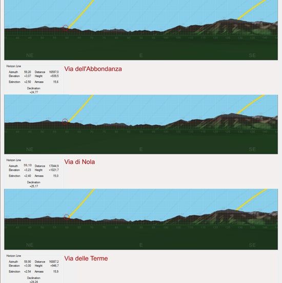
danza, Via di Nola, and Via delle Terme are pointing at (fig. 3) in comparison to the
position of the rising sun at summer solstice.

3.Projecting the Pompeian Streets on the Celestial Sphere: Azimuth,
Altitude and Declination

The aim of this section is to analyse data from the available digital models to test
Nissen’s observation with more sophi-
sticated tools. For this scope, the direc-
tion of each road should be geometri-
cally projected on the celestial sphere,22
in a point described by two celestial co-
ordinates, azimuth and altitude. There-
fore, the first step for applying skyscape
archaeology is to measure the azimuth
values of the selected axial directions for
structures of interest. The azimuth of a
given direction is here regarded as the
clockwise angle from the True North.23
A recent geo-referenced cartography
of Pompeii was used within GIS sof-
tware for this task.24 For each route,
the geometrical line running midway
between the two lateral side walls of
the street was considered as the main
axis of orientation of a route.25 This was
not always possible since streets are not
fully straight,26 due to the nature of the
architectonic components.27 The mo- Figure 3. Orientation of Pompeian streets projected on the celestial sphere just above
                                            the local horizon. The skyline looking north-east from Via dell’Abbondanza, Via di Nola,
difications in the different phases of ur- Via delle Terme is characterised by Monte Torrenone and Monte Faitaldo. Note how the
ban development might have affected apparent position of the landscape, for instance the azimuth of Monte Torrenone peak,
                                                        varies accordingly to the view point. The street azimuth values are derived from QGIS
                                                        after Morichi et al. 2018. (adapted from PeakFinder 2020 by Ilaria Cristofaro).

22   Karttunen et al. 2003, 14.
23   Karttunen et al. 2003, 15; Zotti and Wolf 2020, 218.
24   Morichi et al. 2018; The meridian convergence value γ=-0.34° was determined on the me-
  dium value indicated on the regional technical cartography CTR from Regione Campania.
  Within the software QGIS, used for cartographic analysis, some plug-ins allow to directly me-
  asure azimuth values of a given direction with consideration of the meridian convergence. In
  alternative, azimuth values can be measured in satellite imagery within Google Earth by using
  the ruler tool.
25 Prendergast 2014, 391.
26 For example Via di Nola presents a slight curvature at its end.
27 Ruggles 2014b, 375-380.

5                                                                                             GROMA 5 - 2020
Figure 4. Skyscape archaeology database with values shown in decimal degrees. All the landscape and skyscape targets of structures orientation data are
kept for completeness, but it is not presumed these were intended by the builders. These are orientations but not necessarily alignments (see last section).
Here, only the east direction is shown. The altitude values were measured with PeakFinder 2020 and, due to the different software programs used, there
are divergences (±0°.1) in respect to altitude values in fig. 6 (elaborated by Ilaria Cristofaro).

                           the orientation of the Archaic structures, such as the original delimitation of the
                           blocks used as foundations.28 Therefore, the most correct methodology is to define
                           an average orientation of the block fronts and, in the case of significant differences,
                           to take into consideration the topographical reasons for such deviations and any
                           archaeological data available to explain these variations. All data were recorded
                           within an excel file (fig. 4). All azimuth values for streets were measured on GIS
                           software using the “Azimuth Measurement” plug-in v. 0.2.2 with a precision of
                           0.01°, on the basis of Morichi’s vectoral cartography.29

                           28  On this aspect of continuity of orientations and discontinuity of occupation see Coarelli 2008,
                             174-175 and the extensive discussion in the same volume Nuove ricerche archeologiche nell’area ve-
                             suviana (scavi 2003-2006), 508 ff. However, it has been shown how the alignments underlying
                             the planning of the urban layout of Pompeii were drawn in the 6th century BC, taken up and
                             respected in later periods, see Giglio 2016, 29-30.
                           29 Morichi et al. 2018.

                           Ilaria Cristofaro, Michele Silani                                                                                                   6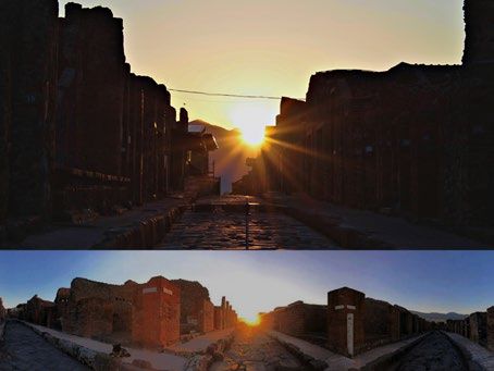
For each road direction, the second step is to measure the skyline altitude defined
as the angular distance above the mathematical horizon, or astronomical horizon.30
The local horizon profile is the visible line where ground and sky meet: indeed,
mountains and hills can alter the visibility of a celestial body’s rising and setting
in comparison to where it would rise if the horizon had an altitude of 0°. When
the horizon profile is uneven (see fig. 2), the skyline altitude variates accordingly.
Altitude values were measured from digital terrain models based on Shuttle Radar
Topography Mission 90m (SRTM 3”) resolution datasets, and converted into a
horizon profile.31 For such resolution datasets and for horizon distances larger than
c. 10 km, as in the case of Monte Torrenone and Faitaldo which are c. 18 km fara-
way from Pompeii, the accuracy is c. 0.1°.32 It is important to notice that for a vast
area, such as the 66 hectares plateau of Pompeii, the skyline profile is dependent on
a perspective related to a precise observation point. Indeed, mountains seen from
different locations appear positioned differently in respect to the azimuth grid: for
example, the azimuth of Monte Torrenone peak stands at 58.8° from Via di Nola,
but at 58.1° if seen from Via dell’Abbondanza (fig. 3). Therefore, for each observa-
tion point, generally by standing at the beginning of the road (fig. 3), the correct
panorama was reconstructed. In summary, for each street azimuth value (az), its
relative skyline altitude value (h) was measured: this results in a precise point on the
celestial sphere, based on the two coordinates of the “horizontal system”.33
The third step is to convert data into astronomical declination values in order to
identify possible astronomical events for a specific sightline, such as an urban road
or temple axis. Declination is a celestial coordinate of the “equatorial coordinate
system” not measurable on site but calculated by converting the coordinates from
the horizontal system (azimuth/altitude).34 Thus, having the latitude (φ) of the site,
the declination (δ) is determined as followed:35
                      sin δ = (sin φ × sin h )+ (cos φ × cos h × cos az)
Declination is a coordinate fixed on the celestial sphere and ideal to identify cele-
stial objects since these generally move along precise declination lines.36 An over-
view of all possible astronomical alignments can be achieved by numerically com-

30     Karttunen et al. 2003, 14; Zotti and Wolf 2020, 218.
31     To convert DTM into horizon profile we used the software programs HeyWhatsThat at
     https://www.heywhatsthat.com/, PeakFinder at https://www.peakfinder.org/, and Horizon (©
     1998-2020 Andrew Smith) available at http://www.agksmith.net/horizon.
32     Patat 2011. For shorter distances, resolution can be enhanced with a DTM from IGM data
     each 20m.
33     Karttunen et al. 2003, 14-15; Ruggles 2014a, 460.
34     Karttunen et al. 2003, 15-17; Ruggles 2014a, 460-463.
35     Ruggles 2014a, 461; a convertor is available at https://www3.cliveruggles.com/index.php/
     tools/declination-calculator.
36     Ruggles 2014a, 460.

7                                                                            GROMA 5 - 2020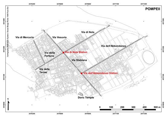
paring the calculated declinations, resulting from projecting the Pompeian streets
                          into the celestial sphere, with the list of main solar and lunar declinations, as well
                          as stellar ones, in a chosen epoch.37 A declination value can corresponds to one or
                          more celestial body visible at a different time or season, and all matching values
                          should be recorded in the database for completeness purposes (fig. 4).38 The dif-
                          ference between the street sightline declination and the celestial body declination
                          should have a margin of error within 1°-2° maximum, depending by the structu-
                          ral conditions of the archaeological site.
                          The forth step is to bring all previous information together and further test possible
                          astronomical orientations with a virtual reconstruction of ancient skies with sof-
                          tware programs, moving from a numerical to a visual comparison. For the present
                          research, Stellarium which is an open-source planetarium software program, was
                          used to go back in time to visualise the Pompeian sky of the 7th-6th century BC.39
                          An artificial polygonal panorama was also added within the astronomical softwa-
                          re to virtually recreate the local DTM horizon profile within the skyscape (fig.
                          5).40 Celestial coordinates resulting from Pompeii streets sightlines were visually
                          compared with the position of main sky events such as the sun’s course at summer
                          solstice. This can be visually plotted using “archaeolines” within Stellarium.41 One
Figure 5. Rising of       outcome from this analysis was that a number of streets and templar structures
the sun at summer
solstice behind Monte
Faitaldo in the 6th
century BC as seen
from “Via dell’Ab-
bondanza Station”,
Pompeii. In orange
the horizontal coordi-
nate system (altitude/
azimuth); in violet the
equatorial coordinate
system (right ascen-
sion/declination). The
fieldwork computed
measurements of
the sun’s azimuth
60°.374 (60° 22’
27’’) for summer sol-
stice in 600 BC corre-
sponds to the value of
the Stellarium digital
reconstruction (60°
22’ 26’’). Horizon
profile after SRTM
3” computed with
software Horizon
(©Andrew Smith) and
Stellarium 2020.

                          37   Ruggles 1999, 57; Ruggles 2014c, 475-480.
                          38   Ruggles 2014b, 376.
                          39   Available at https://stellarium.org/; Zotti and Wolf 2020.
                          40   Zotti and Wolf 2020, 66.
                          41   Zotti 2016.

                          Ilaria Cristofaro, Michele Silani                                                   8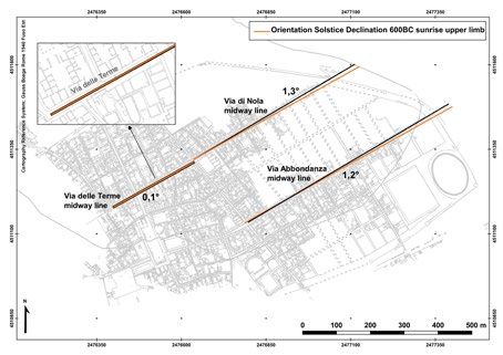
Figure 6. Eastern
                                                                                         horizon profiles as
                                                                                         seen from different
                                                                                         cross-roads at
                                                                                         Pompeii, comparing
                                                                                         the direction of
                                                                                         Pompeian streets
                                                                                         with position of the
                                                                                         rising sun at solstices
                                                                                         at the beginning of
                                                                                         the 6th century BC.
                                                                                         Created with the
                                                                                         software Horizon
                                                                                         (©Andrew Smith),
                                                                                         with processed DTM
                                                                                         data from the Shuttle
                                                                                         Radar Topography
                                                                                         Mission 90m (SRTM
                                                                                         3”). The red circles re-
                                                                                         present the sightline
                                                                                         of the roads with an
                                                                                         apparent diameter or
                                                                                         error of ±1°. The yel-
                                                                                         low line on the left is
                                                                                         the course of the sun
                                                                                         at summer solstice
                                                                                         in 600 BC, and the
                                                                                         right one is the winter
                                                                                         solstice sun’s path
                                                                                         (adapted by Ilaria
                                                                                         Cristofaro).

seemed to be directed towards the position of the rising sun at summer solstice in
the Archaic period, with a variable divergence of 1°-2° (fig. 4). In order to test
the accuracy of the digital models, and to document the occurrence of the celestial
event on site, the investigation progressed with the acquisition and analysis of field
data as discussed in the next section.
                                                                                  I.C

4. Fieldwork and Data Analysis: The Position of the Sun Rising abo-
ve the Mountains

On site autoptic perception and fieldwork are crucial elements in any skyscape
archaeology investigation. The precision of digital models and the virtual recon-
structions proposed in the previous section are here tested according to direct evi-

9                                                                     GROMA 5 - 2020
dence measured in the field. For this task, a fieldwork campaign for observation
and measurement at the site of Pompeii for the day of summer solstice, 21st June
2020 was planned. To test the hypothesis of the orientation of the eastern sector of
the urban grid with the rising summer solstice sun, two observation points were
defined by dividing our working team into two groups:42 the first group was stan-
ding at the crossroad between Via Stabiana and Via dell’Abbondanza, named “Via
dell’Abbondanza Station”; the second, at the intersection between Via Stabiana and
Via di Nola, named “Via di Nola Station” (fig.1). At the first crossroad, the sun rose
on the right slope of Monte Faitaldo; whereas, at the second observation point,
the position of the rising sun appeared on the top peak of the same mountain. We
recorded the position of rising sun in respect to the local landscape with photo-
graphic documentations (fig. 9).
In order to measure the sun position on the celestial sphere, from “Via dell’Abbon-
danza Station” a survey was carried out by using the shadow projection of a gno-
mon on the ground, technique used since antiquity for orientation in respect to
the sun.43 For use as a gno-
mon, a 1.65 m long telesco-
pic pole with a prism was
fixed on the planking level
and kept in a vertical posi-
tion by using the in-built
spherical bubble level. With
a Leica TS16 Total Station,
with an angular precision of
1’’, three points were mea-
sured: the gnomonic pole
base (B) and top (C), and its
shadow projection on the
ground (A). Measurements
were done 5 minutes after
the first visible ray of the
rising of the sun. The same
Figure 7. Orientation of the sun according to fieldwork measurements and calculations in relation to the
procedure was repeated 35
position of Monte Torrenone and Faitaldo (c. 18 km from Pompeii). “Orientation Solstice Gnomon” (in minutes after the sun rising
blue) is the direction of the gnomon shadow on 21/06/2020, 5 minutes after the sun rising. “Orientation
Solstice Declination 600BC” (in red) is the previous measurement with the correction for ecliptic obliquity
in order to have control data
in 600 BC. “Orientation Solstice Declination 600BC sunrise upper limb” (orange) is the orientation of the for comparison. In order to
geo-reference the survey
sun at the exact moment of its upper limb rising in the Archaic period and represents the final direction to
be compared with Via dell’Abbondanza midway line (black). Finally, “Orientation Solstice Declination 600
BC mathematical horizon” (pink) is a test applying the suggestion by Hyginus to sight the sun as if above with the local cartographic
an ideal zero-horizon (elaborated by Michele Silani).
42 We would like to thanks Prof. Carlo Rescigno and Prof.ssa Carmela Capaldi for assisting the
observations.
43 Herodotus, Histories II 109.
Ilaria Cristofaro, Michele Silani 10projection system, from “Via dell’Abbondanza Station” three anchorage points
from the Parco Archeologico di Pompei topographical grid were rigorously mea-
sured.44 Thanks to the acquisition of these data, it was possible to determine the
position of the sun 5 minutes after its local rising on 21/06/2020 and to display its
orientation on the map (“orientation solstice gnomon” on fig. 7). Indeed, as men-
tioned in the previous section, the parameters necessary to determine the position
of any points on the celestial sphere are azimuth and altitude: in this case, the sun
position was calculated with the direction of the gnomon shadow (az) and the an-
gle BÂC (h). The results of the fieldwork have given an azimuth value of 61.55°
in the line between the gnomon and its shadow projection and reported on the
site plan with the correction
given by the meridian con-
vergence inherent to the
georeferenced cartography
used (“orientation solstice
gnomon” on fig. 7).45 The
angle BÂC gave the altitude
value of 3.277°, also consi-
dering the penumbra ambi-
guity.46
From these values, at the
latitude of 40.75° that is
precisely “Via dell’Abbon-
danza Station”,47 the calcu-
lated declination of the sun
is 23.43°.48 This declination
value corresponds to the ex-
pected value of the obliqui- Figure 8. Comparing the orientation of street centrelines (black) with the direction of the sunrise upper
limb rising on summer solstice in 600 BC (orange lines). All orange lines are created parallel to each
ty of the ecliptic ε for 21st other’s starting from the one at Via dell’Abbondanza, obtained after fieldwork measurements and data
June 2020, confirming the analysis for the sun position. The geometrical translation is possible due to the sun infinite distance in
respect to the urban dimensions, since at that precise moment the sun has the same azimuth (60°.37) for
consistency of the fieldwork the whole plateau of Pompei (elaborated by Michele Silani).
44 Other control measurements were done on archaeological structures visible both on site and
on Pompeii topographical reference basis from Morichi et al. 2018.
45 See note 24.
46 The fuzziness of the gnomon shadow is due to the fact that the sun is not a point source of
light but has an apparent diameter of 0.5°; therefore, we added a penumbra error of ±0.25° to
the value of the altitude.
47 For the conversion of the latitude value in geographic coordinates WGS84 starting from
cartographic coordinates with Gauss Boaga Fuso Est Roma 1940, the national IGM software
Verto 3k was used.
48 Ruggles 2014a, 460-462.
11 GROMA 5 - 2020on site measurements.49
Furthermore, it was neces-
sary to consider the exact
moment when the sun was
rising, since field measu-
rements have a delay of 5
minutes in respect to it. For
this reason a reassessment
of the bearings was carried
out, considering that the
hour angle of the sun does
not flow at an even rate,
the sun in those 5 minutes
was running 1.096° along
the declination line, which
is inclined in respect to the
astronomical horizon to an
angle corresponding to the
Figure 9. Top: Rising of the sun at summer solstice from “Via dell’Abbondanza Station”, Pompeii, 21st June
2020. Consider that the position of the sun in the 7th -6th cent. BC was half a degree on the left than co-latitude.50 After having
nowadays (photo by Ilaria Cristofaro). Below: Panorama image of the rising of the sun at summer solstice subtracting those 5 minutes,
from “Via di Nola Station”, with Via Vesuvio on the left and Via Stabiana on the right, Pompeii, 21st June
2020 (photo by Carlo Rescigno). the new computed values
are 60.83° for the azimuth
and 2.45° for altitude for
the upper limb of the sun rising on 21/06/2020. To calculate the position of the
sun at its rising in the 7th-6th century BC, the small variation in the oscillation of
the obliquity of the ecliptic ε should be added.51 Even if the year 600 BC was used
as a reference date for the urban foundation, not much variation in the ecliptic ε
and the sun position would exist for few centuries of difference. Therefore, we
substituted the sun obliquity of the ecliptic ε value for AD 2020 to the one for 600
BC: in particular, the solstitial declination of the sun has a difference in declination
of +0.33°.52 Finally, from the sun’s Archaic declination value, it was possible to cal-
culate back the value of the sun azimuth in the Archaic period,53 in order to com-
pare it with the orientation of the urban grid of Pompeii: keeping unchanged the
altitude and the latitude, in 600 BC the summer solstice rising sun azimuth value of
49 Ruggles 1999, 57; Ruggles 2014a, 465; Data for ε are derived from Laskar (1986) using the
calculator provided by PH Science Labs at http://www. neoprogrammics.com/obliquity_of_
the_ecliptic/
50 Karttunen et al. 2003, 31-32.
51 Ruggles 2014c, 479-480.
52 Ruggles 2014c, 479-481; Data for ε are derived from Laskar (1986) using the calculator provi-
ded by PH Science Labs at http://www. neoprogrammics.com/obliquity_of_the_ecliptic/
53 Karttunen et al. 2003, 31-32.
Ilaria Cristofaro, Michele Silani 1260.37° (60° 22’ 27’’) was obtained (“orientation solstice declination 600 BC sunrise upper limb” on fig. 7). Due to the progressive decrease of the ecliptic obliquity over two and half millennia, the sun now rises half a degree, which corresponds to the width of the sun diameter, south of its rising position in 600 BC.54 This result is fully compatible with Stellarium data for summer solstice on 29/06/-600 at 4:44:43 from “Via dell’Abbondanza Station” and the SRTM 3” horizon profile by Horizon software (fig. 5). The wider error on the altitude 2.45° (2° 26’ 46’’) in respect to 2° 46’ 55’’ by Stellarium derives from the fuzziness of the penumbra ambiguity in the gnomon shadow. This obtained result is diverging from 1.2° in respect to the mean orientation of Via dell’Abbondanza (figs. 7-8) and this is compatible with the accuracy expected for the determination of an astronomical orientation in antiquity. Irregularities in the urban modifications following the moment of the city foundation until AD 79 have clearly conditioned our determination of the mean orientation of Via dell’Abbondanza.55 However, results show that Via delle Terme has the most precise orientation to the rising summer solstice sun among the roads surveyed (fig. 8); therefore, from that street autoptic observations and photographic documentation will be produced during the next solstice. Moreover, the altitude value obtained (2.45°) is referred to the center of the solar disk and compatible with the presence of Monte Faitaldo on the horizon. The mountain would have partially covered the sun, whose upper limb would have been visible, exactly at its rising. The impor- tance of the landscape and the local skyline was already considered in antiquity, as confirmed by the writing of ancient Gromatics, or Roman agrimensores,56 in particular Hyginus, when he questioned: et si kardo a monte non longe nascatur siue decimanus, quomodo potest cursus conprehendi recte, cum ferramento sol occiderit et trans montern sol adhuc luceat et eisdem ipsis adhuc campis in ulteriore parte resplendeat?57 If the kardo or decumanus originates not far from the mountain, how can the course (of the sun) be sighted properly, if the sun has set on the ferramentum, but is still shining beyond the mountain and beaming down on the very same plain in the more distant area?58 In the case of Pompeii, the presence of Monte Torrenone and Monte Faitaldo se- ems to have been considered in the ancient planning of the town. As a confirma- tion, we tested the possibility of having a zero horizon, by sighting the solstitial sun 54 Ruggles 1999, 57. 55 Prendergast 2014, 391. 56 For recent evidence of Gromatics in Pompeii see Ferro, Magli, and Osanna 2020. 57 Hyg. const. limit. 12-16 Th.; see the illustration from the codexes of the Gromatics (Rome, Vat. Pal. Lat. 1564, fol. 92r), fig. 98a Th., 98 C. in Dilke 1967, pl. 4. 58 Campbell 2000, 146-147. 13 GROMA 5 - 2020
rising above an ideal flat horizon with no mountains according to the suggestion
by Hyginus: this orientation does not conform with the urban layout (“orientation
solstice declination 600 BC mathematical horizon” on fig. 7). More appropriate to
the present analysis are the words of the agrimensor Frontinus, who wrote that
multi mobilem solis ortum et occasum secuti uariarunt hanc rationem. sic uti[que] effectum est, ut decimani spec-
tarent ex qua parte sol eo tempore, quo mensura acta est, oriebatur59
many have followed the variable rising and setting of the sun and altered this principle.60 Indeed they have arranged
so that the decumani faced from the part (of the heavens) where the sun was rising at the time when the survey
was carried out.61
The definition of the visible horizon profile from a specified point is a central issue
for investigations relating the relationship between astronomical and on-site orien-
tations. For this reason, more data have been acquired, still in elaboration, for other
relevant positions of Pompeii topography, corresponding to the two urban Archaic
sanctuaries, the Apollo Temple and the Doric Temple, as well as at the crossroad ne-
arby the Temple of Fortuna Augusta. Horizon profiles, together with archaeological
structures survey, will be inserted within the software Stellarium in order to refine the
accuracy of the reconstructions and realize new cases study, since the solutions acqui-
red on site fieldwork just discussed resulted fully compatible with the digital models.
M.S.
5.Preliminary Considerations towards a Possible Interpretation:
Orientation versus Alignment in Foundation Rituals
Different conventions exist in relation to use of the term orientation and ali-
gnment.62 If orientation is meant to be “the measured direction of a structure’s
façade or axis with respect to the local meridian (azimuth)”, the idea of alignment
implies the original intention of directing a monument façade or axis towards a de-
terminate target beyond any coincidence.63 The question of intentionality is, the-
refore, a central issue. Efrosyni Boutsikas and Clive Ruggles pointed out that the
“fundamental methodological problem” in archaeoastronomy consists in the fact
that a determinate architectonic orientation must point somewhere - in the land or
59 Frontino de limit. 14, 14-17 Th.
60 The principle of directing decumani from east to west.
61 Campbell 2000, 11.
62 Prendergast 2014, 389.
63 Prendergast 2014, 391.
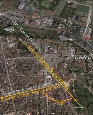
Ilaria Cristofaro, Michele Silani 14skyscape (fig. 4).64 Moreover, whereas the landscape changes only over long time periods, the sky’s movement provides a wide range of astronomical possibilities for one single orientation. Thus, any claims for a particular intentional orienta- tion, or alignment, should be supported by archaeological evidence and culturally contextualized. Bradley E. Schaefer (2006) proposed a useful manner to proceed.65 He argued that for claiming intentionality three or more conditions should be sa- tisfied: first, the orientation should be statistically significant (3σ or better); second, there should be archaeological evidence for the orientation intentionality; third, there should be ethnographical or anthropological evidence on the symbolic value of the alignment, which means that any archaeoastronomical orientation needs to be explained within the specific cultural context in order to give sense to a particu- lar interpretation. As Stanisław Iwaniszewski considered, the skyscape’s experience is related to particular cultural, social, technological and environmental conditions; hence, it became essential to intertwine several disciplines in order to justify the fieldwork’s measurements within a contextualized interpretation.66 According to Schaefer, to calculate the statistical significance in respect to the null hypothesis, which implies that an orientation is accidental, the probability that a single orientation within a single site corresponds within 1° (±1) to a solar di- rection, cardinal or solstitial, is 1/22.5.67 This is due to considering that the eight main solar rising and setting positions (four cardinal and four solstitial) occupies an azimuth value ±1° for a whole circle of 360°: in total they cover 16°, or 2° each 8 directions, that is 4.4% of the whole circle of the horizon. In a gaussian statistic this probability corresponds to 2.08 σ. Thus, quoting Vito Francesco Polcaro, the probability that an orientation found in “one of the eight fundamental solar direc- tions is due to chance is significantly high”, therefore its factual presence “does not prove itself that it was intended by builders”.68 In the case of Pompei, apart from the urban fabric and all the monuments oriented accordingly to it, there is another relevant archaic structure oriented towards summer solstice: the Doric Temple, situated on a promontory on the southern limit of the city (fig. 1). This has its main axis with an azimuth of 300.25°, pointing towards the city plateau, with the altitude of the local bare ground horizon of 1.7°. Its own very peculiar orientation was not affected by the topographical contexts: in particular, looking towards the cella, the temple’s prolonged axis pointed within an approximation of 1° towards the position of the setting sun at summer solstice in the 7th-6th century BC (fig. 10). The same cannot be true for the reverse view, looking south-east with the back at the temple entrance. At the time of winter solstice, a mountain delays the sunrise 64 Boutsikas and Ruggles 2011, 59. 65 Schaefer 2006. 66 Iwaniszewski, 2014, 323. 67 Schaefer 2006. 68 Polcaro 2016, 2. 15 GROMA 5 - 2020
and this shifts the azimuth of the rising sun
                                                                              so as not to correspond with the temple’s
                                                                              axis, therefore excluding the possibility of
                                                                              alignment.69 Thus, it is possible to calcu-
                                                                              late the null hypothesis that the summer
                                                                              solstitial coexistence of the peculiar orien-
                                                                              tation of the Doric temple, together with
                                                                              the urban grid, is due to chance, assuming
                                                                              they are statistically independent. This
                                                                              corresponds to the composite probability
                                                                              that two orientations within a single site
                                                                              points at the eight fundamental solar di-
                                                                              rections is due to chance is 1/506.25, or
                                                                              0.2%. In conclusion, the probability that
                                                                              two orientations in a single site pointing at
                                                                              relevant solar directions is not coincidental
                                                                              is 99.8%, which corresponds to 3.5σ and is
                                                                              therefore statistically significant. Thus, the
                                                                              first test is successfully passed.
                                                                                             The direct archaeological evidence may
                                                                                             give some hints to confirm the solstitial
                                                                                             alignments. The extended axis of the Do-
Figure 10. The top yellow line shows the direction of the Doric Temple’s main axis
                                                                                             ric Temple, as well as the facing heroon, is
with an azimuth of 300°.25 (towards north-west): considering the altitude of 1°.7,           diagonally crossing the middle of the Fo-
this direction points at the summer solstice sunset in the Archaic period (±1°). The
bottom yellow line is the direction of summer solstice sunrise in line with Via delle
                                                                                             rum, to unite and align with the very last
Terme. At the cross-road between Via delle Terme and the last trait of Via Conso-            part of Via Consolare (fig. 10). This asso-
lare, the angle of c. 120° of the two solstitial diagonals is still visible in the viability
(adapted from Google Earth 2020 by Ilaria Cristofaro).                                       ciation was already noted by Filippo Co-
                                                                                             arelli, stating that there might have been
                                                                                             an old track connecting the road coming
                             from the Salinae Herculeae, called viu Sarinu, to the Doric Temple, in a cult dedica-
                             ted to Hercules in relation to the salt market.70 From the present analysis new data
                             can be added to this theory, since Via delle Terme represents the best fit to the rising
                             midsummer sun among the streets surveyed (figs. 6 and 8). Between via Consolare
                             and Via delle Terme the angle of 120° might reflect the intersection of the two sol-
                             stitial directions at midsummer time, one sightline coming from the Doric Temple
                             towards the sunset, the other pointing at sunrise above Monte Faitaldo-Torrenone
                             (fig. 10). If the summer solstice played a part in the ritual temporality and spatiality
                             of the city foundation, and if the Doric Temple preserved such a memory with its

                       69  For this reason we excluded the possible orientation to winter solstice sunset for the urban
                         grid (on the opposite geometrical side of summer solstice sunrise), but further analysis is needed.
                       70 Coarelli 2001, 98.

                       Ilaria Cristofaro, Michele Silani                                                                              16
orientation, the data here analysed highlight the cross-road between Via Consolare
and Via delle Terme as the central point of the urban planning. Few centuries after,
by the end of the 1st century BC, the Temple of Fortuna Augusta was built near-
by: its orientation does not seem casual since the sanctuary appears as an intrusion
on existing nearby buildings, also obstructing the viability of Via della Fortuna.
This anomaly may find an explanation if the direction of the sun rising at summer
solstice was the target of the temple axis. Indeed, according to Jacqueline Cham-
peaux, in the Roman world at the day of summer solstice a festivity dedicated to
Fortuna was celebrated.71
There are many advantages of using the sun as a point of reference in urban plan-
ning in preference to sighting a mountain, as De Caro suggested.72 Due to the
sun’s infinite distance with respect to Earth, orientation to the sun was possible in
many sectors of a site, even where distant from each other, its rays always appea-
ring parallel at multiple places (fig. 8). In comparison, sighting a nearby mountain
from different distant points on a site would introduce parallax errors causing stre-
ets not to be parallel (fig. 3): in the case of Pompeii, although Via di Nola is orien-
ted towards Monte Torrenone, this is not true for Via dell’Abbondanza or Via delle
Terme. Furthermore, solar and topographical (mountain and relative river springs)
solutions need not be mutually exclusive, if considering that the Roman festivity
dedicated to Fortuna was celebrated at summer solstice at the local fluvial divini-
ty and known as the Tiberina descensio.73 Therefore, De Caro’s hypothesis will be
further scrutinised by testing the nearby urban layout of Nuceria Alfaterna, whose
orientation was suggested to point at the same mountain peak.74
How such archaeological evidence might be related to the temporality of foundation
rituals will be the topic of analysis in future research. Finally, apart for calendric pur-
poses more proper to temple rituality, other possible interpretations of such specific
orientation in the urban grid include the function of guaranteeing the right solar ir-
radiation across the year to all houses façades.75 This intention might explain the gre-
ater error attested for the eastern part of the grid. This and other interpretations will
be further explored in the future advancement of this research by comparing other
urban settlements to better understand the role of the sky within foundation rituals.
I.C.
71 Champeaux 1982, 207-234.
72 De Caro 1992, 81-83.
73 Champeaux 1982, 207-224; De Caro 1992, 82-85.
74 De Caro 1992, tav. 7.
75 Vinaccia 1939, 210-215.
17 GROMA 5 - 20206.Conclusion
Skyscape archaeology explores meanings and functions attributed to celestial phe-
nomena by human groups within the specificity of each cultural perspective. The
interrelationship between the skyscape, the horizon profile and the geomorpho-
logical landscape creates a wider understanding of the site in examination. For the
case study of Pompeii, a starting hypothesis by Nissen was tested by employing
digital reconstruction of the land- and skyscape. The fieldwork has proven the
compatibly of direct data with the digital models. The orientations of Via dell’Ab-
bondanza, Via di Nola, and Via delle Terme were compared to the position of the
rising sun at summer solstice in the Archaic period above Monte Torrenone and
Faitaldo. The best fit result was for Via delle Terme, orientated towards the solsti-
tial sun within 0.5°, in respect to Via dell’Abbondanza with 1.2° of error, whereas
Via di Nola has a divergence error of 1.3° (fig. 8). The sighting of the sun above
the local horizon for orientating the decumanus is textually attested by Frontinus,
whereas Hyginus suggested a zero-horizon practice not compatible with Pompeii
urban grid. In order to confirm the intentionality of such astronomical alignment,
a statistical test was carried out: considering the co-existence on site of two impor-
tant solar directions, one in the urban grid and the other at the Doric Temple, the
probability that this is coincidental is 0.2%. Moreover, archaeological evidence in
relation to the cult of Heracles at the Doric Temple and the position of Via Con-
solare proposed by Coarelli will be further scrutinised with the additional evidence
of the alignment to the direction of the summer solstice sunset. The intention of
assuring equal solar irradiation all year could be one explanation for the urban grid
and this needs further testing. These preliminary results will be contextualised by
applying the method of skyscape archaeology to other Campanian cities in order
to compare data. Meanwhile other evidence is brought to light, it is possible to
conclude by suggesting the hypothesis that summer solstice had temporal and spa-
tial significance for the planning of ancient Pompeii, as inferred from the orienta-
tion of the urban grid and the Doric Temple.
I.C., M.S.
Bibliography
Avagliano, Alessandra. 2018. Le origini di Pompei: la città tra il VI e il V secolo a.C.
Bulletin antieke beschaving. Supplement, 33. Leuven: Peeters.
Bonghi Jovino, Maria. 2011. “Ripensando Pompei arcaica.” In Corollari: scritti di
antichità etrusche e italiche in omaggio all’opera di Giovanni Colonna, ed. by
Daniele F. Maras, 4-13. Pisa: Fabrizio Serra.
Boutsikas, Efrosyni. 2007-2008. “Placing Greek Temples: An Archaeoastronomical
Study of the Orientation of Ancient Greek Religious Structures.” Archaeoastro-
nomy: The Journal of Astronomy in Culture, 21: 4-19.
Ilaria Cristofaro, Michele Silani 18Boutsikas, Efrosyni, and Clive Ruggles. 2011. “Temples, Stars, and Ritual Landsca- pes: The Potential for Archeoastronomy in Ancient Greece.” American Journal of Archaeology, 115 (1): 55-68. Briquel, Dominique. 2008. “L’espace consacré chez les Étrusques: réflexions sur le rituel étrusco-romain de fondation des cités”. In Saturnia Tellus : definizioni dello spazio consacrato in ambiente etrusco, italico, fenicio-punico, iberico e celtico, Atti convegno internazionale, Roma, 10-12 Novembre 2004, ed. by Xavier Dupré Raventós, Sergio Ribichini, and Stéphane Verger, 27-47. Roma: Consiglio Nazio- nale delle Ricerche. Campbell, Brian. 2000. The Writings Of The Roman Land Surveyors. Journal of Roman Studies Monograph, 9. London: The Society For The Promotion Of Roman Studies. Campion, Nicholas. 2015. “Skyscapes: Locating Archaeoastronomy within Acade- mia.” In Skyscapes: The Role and Importance of the Sky in Archaeology, ed. by Fabio Silva and Nicholas Campion, 8-19. Oxford: Oxbow Books. Coarelli, Filippo. 2001. “Il Foro Triangolare: decorazione e funzione.” In Pompei: Scienza e Società. 250° anniversario degli Scavi di Pompei, Convegno Internazio- nale, Napoli, 25-27 novembre 1998, ed. by Pier Giovanni Guzzo, 97-108. Milano. Coarelli, Filippo. 2008. “Il settore nord-occidentale di Pompei e lo sviluppo urbani- stico della città dall’età arcaica al III sec. a.C..” In Nuove ricerche archeologiche nell’area vesuviana (scavi 2003-2006), ed. by Pietro Giovanni Guzzo and Maria Paola Guidobaldi, Studi SAP 25, 173-176. Roma: L’Erma di Bretschneider. Champeaux, Jacqueline. 1982. Fortuna: Le culte de la Fortune à Rome et dans le monde romain. Fortuna dans la religion archaïque, Vol I. Roma: Ecole Française de Rome. Connolly, David. 2016. Archaeoastronomy for Archaeologists. Guide 43, BAJR Seri- es. [online]. www.bajr.org/BAJRGuides/43_ArchaeoAstronomy/43_ArchaeAstro- nomy.pdf Cristofani, Mauro, 2009. “La Fase ‘Etrusca’ di Pompei.” In Pompei, a cura di Fausto Zevi, 17-54. Napoli: Alfredo Guida Editore. De Caro, Stefano. 1992. “Lo Sviluppo Urbanistico Di Pompei.” Atti E Memorie Della Società Magna Grecia, 3: 67–90. Giglio, Marco. 2016. “Considerazioni sull’impianto urbanistico di Pompei.” Vesuvia- na, 8: 11- 48. Guzzo, Pietro Giovanni, and Maria Paola Guidobaldi (eds.). 2008. Nuove ricerche archeologiche nell’area vesuviana (scavi 2003-2006), atti del convegno interna- zionale, Roma, 1-3 febbraio 2007, Studi SAP 25, Roma: L’Erma di Bretschneider. González-García, A.C., A. Rodríguez-Antón, D. Espinosa-Espinosa, M.V. García Quin- tela, and J. Belmonte Aviles. 2019. “Establishing a New Order: The Orientation of Roman Towns Built in the Age of Augustus.” In Archaeoastronomy in the Roman World , ed. by Giulio Magli, Antonio C. González-García, Juan A. Belmonte Aviles, and Elio Antonello, Historical & Cultural Astronomy, 85-102. New York: Springer. Ferro, Luisa, Giulio Magli, and Massimo Osanna. 2020. “Gromatic Images from New Discoveries in Pompeii.” Nexus Network Journal 22: 717–733. 19 GROMA 5 - 2020
Henty, Liz. 2014. “The Archaeoastronomy of Tomnaverie Recumbent Stone Circle: A
  Comparison of Methodologies.” Papers from the Institute of Archaeology, 24 (1):
  1-15.
Holappa, Maija, and Eeva-Maria Viitanen. 2011. “Topographic Conditions in the Urban
  Plan of Pompeii: The urban landscape in 3D.” In The Making of Pompeii: Studies
  in the history and urban development of an ancient town, ed. by Steven J. R. Ellis,
  Journal of Roman Archaeology Supplementary Series, 85:169–89. Portsmouth.
Incerti, Manuela. 2001. “Architettura sacra medioevale ed archeoastronomia.” In
   L’Uomo Antico e il Cosmo, Atti dei Convegni Lincei, 171, ed. by F. Bertola, G.
   Romano, and E. Proverbio, 346–384. Roma: Accademia Nazionale dei Lincei.
Iwaniszewski, Stanisław. 2014. “Cultural Interpretation of Archaeological Evidence
  Relating to Astronomy.” In Handbook of Archaeoastronomy and Ethnoastronomy,
  ed. by Clive L. N. Ruggles, 315-324. New York: Springer.
Laskar, J. 1986. “Secular terms of classical planetary theories using the results of ge-
  neral relativity”. Astron Astrophys 157:57–90
Karttunen, Hannu, Pekka Kröger, Heikki Oja, Markku Poutanen, and Karl Johan Don-
  ner. 2003. Fundamental Astronomy. 4th ed. New York: Springer.
Morichi, Ruggero, Rosario Paone, and Fabia Sampaolo. 2018. POMPEI. Nuova
  cartografia informatizzata georiferita, Quaderni di Nova Bibliotheca Pompeiana.
  Roma: Arbor Sapientiae Editore.
Nissen, Heinrich. 1906. Orientationen: Studien zur Geschichte der Religion. Vol. I.
  Berlin: Weidmann.
Patat, Ferdinando. 2011. “Horizon synthesis for archaeo-astronomical purposes.” In
   Astron. Nachrichten 999, 88: 789–795.
Pernigotti, Antonio Paolo. 2019. “A Contribution to the Study of the Orientation of
   Etruscan Temples.” In Archaeoastronomy in the Roman World , ed. by Giulio Ma-
   gli, Antonio C. González-García, Juan A. Belmonte Aviles, and Elio Antonello, Hi-
   storical & Cultural Astronomy, 3-15. New York: Springer.
Prendergast, Frank. 2014. “Techniques of Field Survey.” In Handbook of Archaeoastro-
   nomy and Ethnoastronomy, ed. by Clive L. N. Ruggles, 389-409. New York: Springer.
Ruggles, Clive. 1999. Astronomy in Prehistoric Britain and Ireland. New Haven and
  London: Yale University Press.
Ruggles, Clive. 2011. “Pushing back the frontiers or still running around the same
  circle? ‘Interpretative archeoastronomy’ thirty years on.” In Proceedings IAU Sym-
  posium No. 278, Proceedings of “Oxford IX” International Symposium on Archae-
  oastronomy (Lima), ed. by Clive L. N. Ruggles, 1-18.
Ruggles, Clive. 2014a. “Basic Concepts of Positional Astronomy.” In Handbook of
  Archaeoastronomy and Ethnoastronomy, ed. by Clive L. N. Ruggles, 459-472. New
  York: Springer.
Ruggles, Clive. 2014b. “Best Practice for Evaluating the Astronomical Significance
  of Archaeological Sites.” In Handbook of Archaeoastronomy and Ethnoastronomy,
  ed. by Clive L. N. Ruggles, 373-388. New York: Springer.

Ilaria Cristofaro, Michele Silani                                                    20
Ruggles, Clive. 2014c. “Long-Term Changes in the Appearance of the Sky.” In
  Handbook of Archaeoastronomy and Ethnoastronomy, ed. by Clive L. N. Ruggles,
  473-482. New York: Springer.
Schaefer, Bradley E.. 2006. “Case Study of Three of the Most Famous Claimed Ar-
  chaeoastronomical Alignments in North America.” In Viewing the Sky Through
  Past and Present Cultures. Proceedings of Oxford VII International Conferences
  on Archaeoastronomy, ed. by Todd W. Bostwick and Bryan Bates, Pueblo Grande
  Museum Anthropological Papers, 15, 27-56. Phoenix: City of Phoenix, Parks and
  Recreation Department.
Silva, Fabio. 2015. “The Role and Importance of the Sky in Archaeology: An Intro-
   duction.” In Skyscapes: The Role and Importance of the Sky in Archaeology, ed. by
   Fabio Silva and Nicholas Campion. Oxford: Oxbow Books.
Sommella, Paolo. 1988. Italia antica: l’urbanistica romana. Roma: Jouvence.
Polcaro, Vito Francesco. 2016. “The Credibility of Archaeoastronomy: A Suggestion
  From Pharmacology?” Mediterranean Archaeology and Archaeometry, 16 (4): 1-5.
Vinaccia, Gaetano. 1939. Il Corso del Sole in Urbanistica ed Edilizia. Milano: Hoepli.
Zotti, Georg. 2016. “Open-Source Virtual Archaeoastronomy.” In Mediterranean Ar-
  chaeology and Archaeometry 16 (4): 17–24.
Zotti, Georg, and Alexander Wolf (eds.). 2020. Stellarium 0.20.3 User Guide. [online].
  https://stellarium.org/

21                                                                    GROMA 5 - 2020
You can also read