British Columbia Dreissenid Mussel Lake Monitoring Field Protocol - DREISSENID MUSSEL FIELD PROTOCOL
←
→
Page content transcription
If your browser does not render page correctly, please read the page content below
DREISSENID MUSSEL FIELD PROTOCOL

    British Columbia Dreissenid Mussel Lake
                  Monitoring Field Protocol

                                   Prepared by: Ecosystems Branch BC
                                   Ministry of Environment and
                                   Climate Change Strategy
                                   January 2020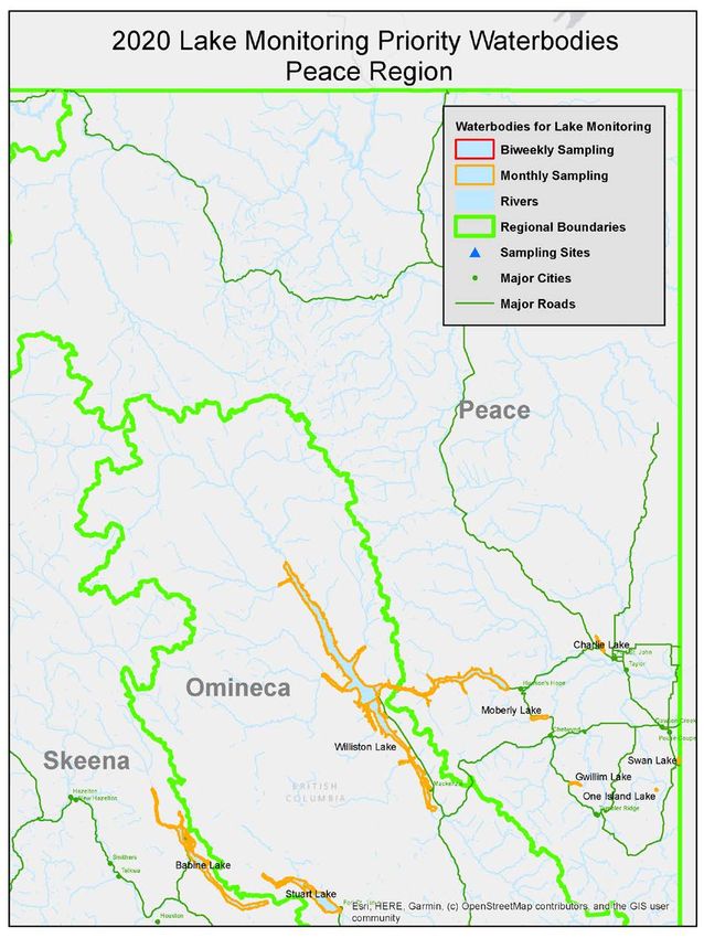
DREISSENID MUSSEL FIELD PROTOCOL

                                                                      September 2017
ACKNOWLEDGEMENTS
Front cover photo credit: Ministry of Environment & Climate Change Strategy.
DREISSENID MUSSEL FIELD PROTOCOL

TABLE OF CONTENTS
1.     INTRODUCTION ................................................................................................................................ 1
2.     DREISSENID MUSSEL IDENTIFICATION .............................................................................................. 2
3.     DREISSENID VELIGER SAMPLING ...................................................................................................... 6
4.     ADULT DREISSENID MUSSEL SAMPLING METHODS ........................................................................ 10
5.     SAFETY ........................................................................................................................................... 12
6.     COLLECTION OF ANCILLARY DATA .................................................................................................. 12
7.     FIELD EQUIPMENT DECONTAMINATION ......................................................................................... 13
8.     PRIORITY WATERBODY LIST ............................................................................................................ 16
LITERATURE AND SOURCES ..................................................................................................................... 22
APPENDIX A: REPORTING INFORMATION ............................................................................................... 23
APPENDIX B: EQUIPMENT FOR PLANKTON TOWS ................................................................................... 24
APPENDIX C: VERTICAL PLANKTON TOW ................................................................................................ 25
APPENDIX D: HORIZONTAL PLANKTON TOW .......................................................................................... 26
APPENDIX E: ARTIFICIAL SUBSTRATE SAMPLERS ..................................................................................... 28
APPENDIX F: SAMPLE PRESERVATION ..................................................................................................... 32
APPENDIX G: LABELING AND SHIPPING OF SAMPLES .............................................................................. 34

                                                                                                                                                      Page | i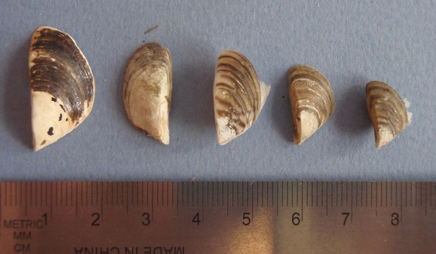
DREISSENID MUSSEL FIELD PROTOCOL

LIST OF TABLES
TABLE 1. PLANKTON NET DIAMETER AND THE CORRESPONDING AREA (M2) OF THE NET MOUTH, USED TO DETERMINE THE MINIMUM
     TOW DEPTH REQUIRED TO ACHIEVE A 1000 LITER TOW VOLUME. ................................................................................. 7

TABLE 2. SUMMARY OF PLANKTON TOW SAMPLING RECOMMENDATIONS. .............................................................................. 9
TABLE 3. DREISSENID MUSSEL DECONTAMINATION METHODS FOR FIELD EQUIPMENT. ............................................................. 16

LIST OF FIGURES
FIGURE 1. INVASIVE DREISSENID MUSSELS WITH SCALE REFERENCE (PHOTO: BC ENV).............................................................. 2
FIGURE 2. SIZE COMPARISON BETWEEN INVASIVE ZEBRA AND QUAGGA MUSSELS (TOP) VERSUS NATIVE MUSSELS (BOTTOM) (PHOTO
     CREDIT: BC ENV) ............................................................................................................................................... 2

FIGURE 3. MOUNTAIN RIDGED MUSSEL (GONIDEA ANGULATA) NATIVE TO BC. PHOTO CREDIT: THE XERCES SOCIETY..................... 3
FIGURE 4. MARINE BLUE MUSSEL (MYTILUS EDULIS) ON THE LEFT AND RIGHT. ......................................................................... 4
FIGURE 5. INVASIVE ASIAN CLAM (CORBICULA FLUMINEA) (LEFT) AND INVASIVE NEW ZEALAND MUDSNAILS (POTAMOPYRGUS
     ANTIPODARUM) (RIGHT). PHOTO CREDIT: PORTLAND STATE UNIVERSITY. ...................................................................... 5

FIGURE 6. PLANKTON NET USED FOR COLLECTING VELIGER SAMPLES AND SECCHI DISK USED FOR MEASURING SECCHI DEPTH. ............ 6
FIGURE 7. AN EXAMPLE OF PLANKTON TOW COLLECTION AT A SITE LOCATION .......................................................................... 7
FIGURE 8. VERTICAL (LEFT) AND HORIZONTAL (RIGHT) PLANKTON TOWS. ................................................................................ 8
FIGURE 9. SHORELINE TOSS (PHOTO: S. WELLS) ................................................................................................................ 9
FIGURE 10. ADULT MUSSELS SAMPLING TOOLS: A) SURFACE SCRAPER, B) SUBSTRATE SAMPLER, C) THATCH RAKE ON A ROPE. ......... 10

                                                                                                                                                            Page | ii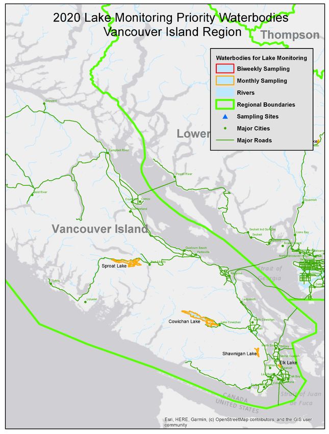
DREISSENID MUSSEL FIELD PROTOCOL

Glossary
Epilimnion: The upper, wind-mixed layer of a thermally stratified lake (Water on the Web 2011).
Eutrophic lakes: A very biologically productive type of lake due to relatively high rates of nutrient
input (usually phosphorus and nitrogen) which leads to excessive plant growth - algae in the open
water, periphyton (attached algae) along the shoreline, and macrophytes (the higher plants we often
call weeds) in the nearshore zone (Water on the Web 2011).
Hypolimnion: The bottom, and most dense layer of a stratified lake. It is typically the coldest layer in
the summer and warmest in the winter (Water on the Web 2011).
Lentic: Body of standing water, ranging from ditches, seeps, ponds, seasonal pools, basin marshes
and lakes.
Lotic: Refers to bodies of water with flowing water (e.g. rivers, streams)
Metalimnion: The middle or transitional zone between the well mixed epilimnion and the colder
hypolimnion layers in a stratified lake. This layer contains the thermocline (Water on the Web 2011).
Secchi Disk: A disk with a 4-6 inch radius, divided into 4 equal quadrates of alternating black and
white colors. It is lowered into a section of shaded water until it can no longer be seen and then
lifted back up until it can be seen once again (Water on the Web 2011).
Spring turnover: Period of complete or nearly complete vertical mixing in the spring after ice-out and
prior to thermal stratification (Water on the Web 2011).
Thermal Stratification: when a lake is broken into distinct horizontal layers due to changes in water
temperature which leads to differences in density (Water on the Web 2011).
Thermocline: The depth at which the temperature gradient is steepest during the summer; usually
this gradient must be at least 10C per meter of depth (Water on the Web 2011).
Veliger: the microscopic free-swimming larvae (veligers) stage of the dreissenid mussel life cycle.

                                                                                                  Page | ii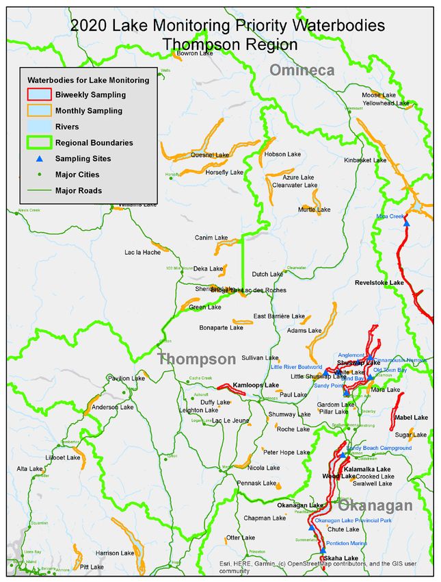
DREISSENID MUSSEL FIELD PROTOCOL

     INTRODUCTION
Monitoring is critical for early detection of new invasive species incursions in British Columbia (BC) and is
an important first step in the Provincial Early Detection Rapid Response (EDRR) plan 1. Zebra (Dreissena
polymorpha) and quagga (Dreissena rostriformis bugensis) mussels (hereafter referred to as Dreissenid),
are two freshwater invasive species that are not currently found in BC but pose significant
environmental and economic risks if they were to be introduced. For more information about zebra and
quagga mussels please visit www.gov.bc.ca/invasivemussels.
BC is a signatory on the 100th Meridian Initiative’s Columbia River Basin (CRB) Interagency Invasive
Species Response Plan: Zebra Mussels and other Dreissena spp. (Heimowitz and Phillips 2008). Under
this Plan the Province is committed to prevention efforts to mitigate the risk of Dreissenid mussels in BC
and across the Pacific Northwest. As part of this commitment the Province has been conducting early
detection monitoring for Dreissenid mussels since 2011. BC is one of the many jurisdictions across North
America conducting early detection monitoring and active prevention efforts for Dreissenid mussels.
Furthermore, as a signatory on the CRB Interagency Invasive Species Response Plan the Province is
committed to following the minimum standard protocols for Dreissenid mussel prevention efforts
including watercraft inspection and decontamination protocols and early detection lake monitoring
protocols.
The Dreissenid mussel life cycle consists of three primary life stages; veligers, juveniles and adults and
the appropriate sampling method varies depending on the target life stage for early detection
monitoring efforts. The sections below outline the appropriate field sampling methods for the different
target life stages of Dreissenid mussels. The applicable protocols pertaining to field sample preservation
and equipment decontamination for Dreissenid mussel monitoring are also outlined below.
In 2018 the Habitat Conservation Trust Foundation (HCTF) launched a granting program to fund lake
monitoring in BC for the presence of Dreissenid mussels. This granting program is in partnership with
the BC Ministry of Environment and Climate Change Strategy (ENV). The grants provide funding for
sampling for the presence of Dreissenid mussels and must follow the protocols outlined in this
document. This includes protocols for conducting plankton tows, deploying substrate samplers, and
preserving and shipping of samples to the ENV designated lab.
This protocol serves as an update to the 2019 BC Dreissenid Mussel Lake Monitoring Protocol to reflect
the minimum recommended protocols being used by other jurisdictions in the Columbia River Basin.
ENV staff have worked closely with HCTF to update this protocol based on feedback received from the
2019 granting cycle. To complete the 2020 HCTF grant application this protocol must be read in detail.
Please refer to the HCTF Invasive Mussels Monitoring Grant guidelines and application instructions for
complete instructions on filling out the grant application.

1
 The Zebra and Quagga Mussel Rapid Response Plan for British Columbia can be downloaded from
https://www.for.gov.bc.ca/hra/invasive-species/Publications/Prov_ZQM_EDRR_Plan.pdf

                                                                                                    Page | 1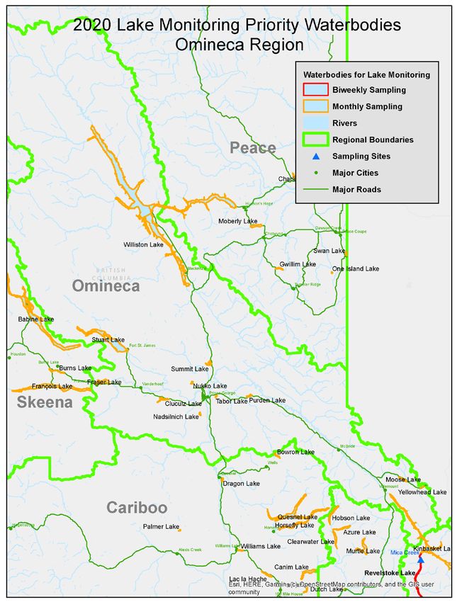
DREISSENID MUSSEL FIELD PROTOCOL

     DREISSENID MUSSEL IDENTIFICATION
Dreissenid mussels are small, triangular bivalves. Adults are typically 1- to 3-cm (0.4- to 1-inch) in shell
length and juveniles range between 350-μm to ~5-mm in size. Shell color varies but they usually have
black and white stripes, although some are all dark and others are cream colored to light orange (Figure
1 and Figure 2). When sampling for adult Dreissenid mussels pay attention that any native mussels
present should not be disturbed (Figure 3). For more information on zebra and quagga mussels please
visit the provincial website.

Figure 1. Invasive Dreissenid mussels with scale reference (Photo: BC ENV)

Figure 2. Size comparison between invasive zebra and quagga mussels (top) versus native mussels (bottom)
(Photo credit: BC ENV)

                                                                                                    Page | 2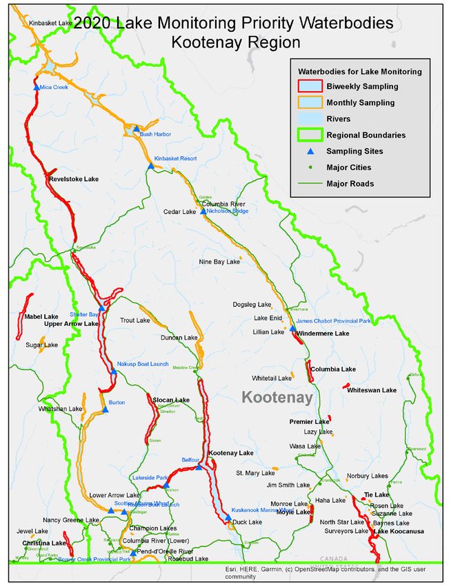
DREISSENID MUSSEL FIELD PROTOCOL

The BC Species and Ecosystems Explorer contains information on mussel species present in BC, including
their federal and/or provincial threat status. The Rocky Mountain Ridged Mussel (Gonidea angulata)
(Figure 3) is native to BC and it was listed as Special Concern under SARA in 2003 and assessed as
Endangered by COSEWIC in 2010. Its presence is limited to the Columbia River system and its tributaries,
including the Okanagan and Kootenay rivers. It is trapezoidal in shape, ~12.5 cm long and ~0.4 cm wide.
Any live specimens of a species at risk should not be disturbed. Collect photographs, and the location
(GPS coordinates preferred) and other information of the specimen and submit it to the BC
Conservation Data Centre (CDC) as soon as possible (see Appendix A for reporting information).
Additional information on identifying native freshwater mussels in BC is available on the CDC website
and more information on other native freshwater molluscs in BC can be found here.

Figure 3. Mountain Ridged Mussel (Gonidea angulata) native to BC. Photo credit: The Xerces Society
Marine (Blue) Mussels
The blue mussel (Mytilus edulis) is a marine mussel that only survives in salt water. Just like the
dreissenid mussel the blue mussel has byssal which allows them to attach onto solids surfaces including
boats. Watercraft traveling from saltwater to freshwater could transport blue mussels into freshwater.
Dead marine mussels have been mistaken for dreissenid mussels due to the small size of juvenile blue
mussels (< 5cm). The blue mussel can be identified by the following characteristics (see Figure 4):
    •   Outside shell is glossy bluish or bluish black, sometimes pale brown.
    •   Inside is generally violet in color.
    •   Pear-shaped and ventrally flattened shell.
    •   Typically full size is 5-10cm, but can range from 2cm to 20cm.
    •   Presence of byssal threads
Blue mussels do not survive in freshwater but it is still important to practice Clean, Drain, Dry when
moving your boat from salt water to freshwater. If you observe any suspected invasive mussels contact
the Provincial Invasive Mussel Defence Program immediately by calling the Conservation Officer
Service Report All Poachers and Polluters Hotline 1-877-952-7277 (RAPP). This allows the trained
Provincial inspectors to respond quickly and take the appropriate steps to identify the mussels and
prevent any unnecessary concern.

                                                                                                     Page | 3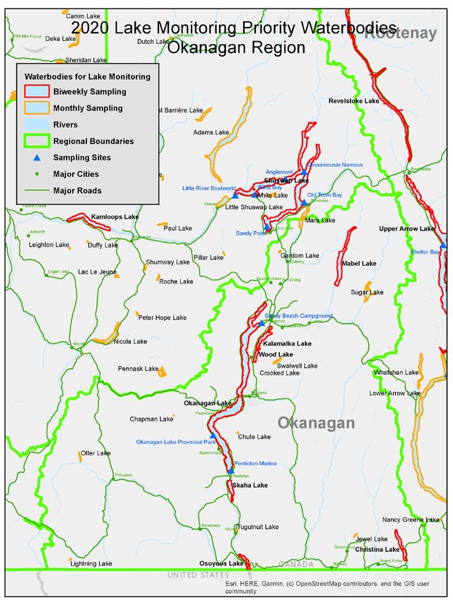
DREISSENID MUSSEL FIELD PROTOCOL

Figure 4. Marine blue mussel (Mytilus edulis) on the left and right.
Other invasive species:
There are two invasive species already present in BC; the Asian clam (Corbicula fluminea) and the New
Zealand mudsnail (Potamopyrgus antipodarum) that could be mistaken for dreissenid mussels during
adult substrate sampling.
Asian clam:
    •   Native to Southeast Asia and parts of central and eastern Australia, Africa, Indonesia and Turkey.
    •   Shell is triangular shaped and usually less than 2.5 cm but up to 6.5 cm in length, and yellow-
        green to light-brown in color with elevated growth rings.
    •   They are found in brackish to freshwater rivers, lakes, streams, canals and reservoirs, in the
        sediment surface or slightly buried in silt, sand or gravel substrates.
    •   They are filter-feeders, and prefer flowing water and they have a low tolerance for polluted or
        near freezing water temperatures.
    •   Four confirmed locations in BC in the Lower Fraser River, one in the Pitt River, two in the
        Coquitlam River and in one lake on Southern-Vancouver Island
    •   A factsheet is available for download on the BC Inter-Ministry Invasive Species Working Group
        website
New Zealand mudsnail
    •   Freshwater snail native to New Zealand.
    •   Are small with cone shaped shells and 5-8 whorls on shell with a pointed end
    •   Grow up to 8 mm in length and 4mm wide and range from light brown to black in colour
    •   Prefer vegetated habitat close to the shore of lakes and low flowing streams with silt and
        organic substrate. This species has high tolerance to various water quality, temperature (above
        freezing), and salinity levels.
    •   Confirmed location in BC is the Somass River near Port Alberni on Vancouver Island.

                                                                                                 Page | 4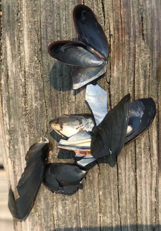
DREISSENID MUSSEL FIELD PROTOCOL

Figure 5. Invasive Asian clam (Corbicula fluminea) (left) and invasive New Zealand mudsnails (Potamopyrgus
antipodarum) (right). Photo credit: Portland State University.

                                                                                                     Page | 5
DREISSENID MUSSEL FIELD PROTOCOL
DREISSENID VELIGER SAMPLING
Plankton tows
Veliger samples are collected using a plankton net and conducting vertical and/or horizontal tows. Due
to their small size dreissenid mussels will pass through mesh > 65µm therefore to effectively sample for
dreissenid mussel veligers the plankton net must have a mesh of 64µm (max 65µm), and 30cm to 50cm
diameter net mouth opening must be used (Figure 6).
Figure 6. Plankton net used for collecting veliger samples and secchi disk used for measuring secchi depth.
Where to Sample
The number of sample sites per waterbody should be scaled to the size and complexity of the
waterbody. For some of the larger and more complex waterbodies a list of specific priority sample sites
have been provided in the table of Priority Waterbodies, these sites are provided as a minimum. A
minimum of three site replicates/plankton tows are recommended at each sample site. When choosing
locations for site replicates/plankton tows, try to select the number and location in such a way to
represent a diversity of areas in the entire water body (i.e. open water and near shore habitats; Figure
7). Site replicate/plankton tow locations should include high use and near shore areas such as marinas,
boat launches, docks, at inlets and outlets of the waterbody (e.g. mouth of tributaries; dams) and in
downwind areas and eddies which can be identified by the accumulation of leaves, pollen and debris on
the surface of the water. Samples should be collected from a boat, if a boat is not available sampling can
take place from a dock and preferably from public docks/marinas with high boat traffic. When sampling
from a dock please use a vertical plankton tow if depth permits or a horizontal plankton tow in
shallower depths.
Page | 6DREISSENID MUSSEL FIELD PROTOCOL
If resources do not permit three site replicates/plankton tows per sample site it is critical that a
minimum of 1000L of water is filtered through the net for each sample site.
Plankton tows for each sample site should be combined into one sample container. The number of tows
at each sample site should be based on the net diameter and the depth of each tow, with the goal of a
minimum total volume of 1000 liters (L) per sample site filtered through the net. The number of tows
per sample site to filter 1000 L can be calculated using the equation below.
Open-water areas of lake
Tow #3
Tow #4
Tow #1
Tow #2
Near-shore areas of lake
Boat
ramp
Shoreline
Figure 7. An example of plankton tow collection at a site location
Vertical Tow Volume
Tow volume (L) = Area of the net mouth (m2) x tow depth (m) x 1000 liters
Example: A 30 cm net is used to collect 3 x 20 meter tows. All 3 of the tows are dispensed into the
sample collection bottle.
0.07 m2 x 60 m x 1000 L/m3 = 4200 liters of source water represented in the bottle
Table 1. Plankton net diameter and the corresponding area (m2) of the net mouth, used to determine the
minimum tow depth required to achieve a 1000 liter tow volume.
Net Diameter Area of Plankton Net Mouth Minimum Tow Depth to get 1000L Total Volume
13cm (5 in) 0.01m2 100m (328 ft)
20cm (8 in) 0.03m2 33.4m (109 ft)
30cm (12in) 0.07m2 14.3m (46.9 ft)
50cm (20in) 0.2m2 5.3m (17.3 ft)
Net clogging can occur in highly eutrophic (productive) lakes when a thin layer of plankton, accumulates
at the inner surface of the net. This blocks water from going into the net water and leads to under
sampling. If clogging occurs, first try reducing the depth of the tow and if needed increase the number of
tows to reach the minimum of 1,000L filtered per site. The depth of the tow can be adjusted to the
Page | 7DREISSENID MUSSEL FIELD PROTOCOL
secchi depth reading (see section 6 for instructions on taking seechi depth). The actual depths and
number of tows should be adjusted depending on the sample site (site depth, location, stratification
etc.) to reach the required minimum of 1,000L filtered per sample site.
WHEN TO SAMPLE
Dreissenid mussels spawning can occur when water temperatures reach ≥9°C. Plankton tow sampling
should begin when water temperature has been maintained at ≥9°C for a minimum of two weeks.
Generally, sampling should occur from May to October period, with the focus of effort in the July to
September when temperatures are optimal for spawning (12°C-18°C). However the timing of the
sampling period will vary by waterbody based on suitable temperature levels (12°C-18°C). Veliger
sampling can be performed anytime during the day but preferably not immediately following a storm or
flooding event. Storm and flooding events can increase water turbidity and hence the time required to
process the sample.
Sampling Methods
Plankton tows can be made in one of two ways, based on the type of the waterbody:
Vertical Tows ‐ For waterbodies with little flow and depth greater than 4m, tows are made by lowering
the net to the desired depth and pulling it back vertically. In waterbodies that stratify (upper and lower
water column separated by thermocline -see glossary for definitions) veligers are found above
(epilimnion) and below (metaliminoin) the thermocline. Therefore, in waterbodies that stratify both the
epilimnion and metaliminoin (above and below the thermocline) should be sampled. The literature
supports that veligers are most concentrated from 0-15m. If stratification levels are unknown the
minimum recommended depth for the vertical plankton tow is 15m. If the depth of stratification is
known, then sample should occur above and below the thermocline. For shallower waters, subtract the
length of the plankton net, plus .5 meters to keep it from hitting the bottom. See Appendix B for a
complete list of equipment for plankton tows and Appendix C for detailed sampling methods.
Figure 8. Vertical (left) and horizontal (right) plankton tows.
Page | 8DREISSENID MUSSEL FIELD PROTOCOL
Horizontal Tows ‐ For waterbodies less than 4m, or that are flowing (drainage ditches, pipes, rivers,
streams, etc.), horizontal tows are recommended. Horizontal tows are made by releasing the net in the
flow and either holding it stationary, or by pulling it back at an oblique angle or horizontal to the surface
of the water. Horizontal tows can be done from a boat (trawling) or from a dock by walking the length of
the dock or using a shoreline toss. See Appendix B for a complete list of equipment and Appendix D
detailed sampling methods.
Figure 9. Shoreline toss (Photo: S. Wells)
Table 2. Summary of plankton tow sampling recommendations.
Parameter Recommendation
Water temperature ≥9°C for a minimum of two weeks
Around floating structures, marinas, inlets, and outlets,
Locations
coves, down-wind areas and eddies
15 m (50 ft) but will depend on depth of waterbody and
Depth
depth of the thermocline
Variable; based on size and complexity of waterbody
Number of sampling sites per waterbody
(some sites provided)
Variable; when possible a minimum of 3, based on
Number of site replicates/plankton tows
depth and net size, minimum 1000 liters per sample
per sampling site
site.
Page | 9DREISSENID MUSSEL FIELD PROTOCOL
ADULT DREISSENID MUSSEL SAMPLING METHODS
The objective of sampling for juvenile and adult Dreissenid mussels is to detect bivalves attached to hard
submerged surfaces in freshwater environments. Dreissenid mussels are one of the few freshwater
mussels capable of adhering to hard surfaces using byssal threads. The adults can only attach to hard
substrate, so in muddy areas they will be found attached to embedded rocks, native clams, or crayfish.
In lakes with little hard substrate, dreissenid mussels may initially settle on sticks, logs, shells or plants,
or sometimes attach directly to sand grains, and later settle onto each other, eventually forming large
mats. Adult Dreissenid mussels can be sampled using a number of different methods such as tactile and
visual inspections of existing submersed surfaces and shoreline areas, a surface scraper (Figure 10a),
artificial settlement substrates (Figure 10b), and a thatch rake on a rope (Figure 10c). A brief
description of these methods is provided below but for the purposes of monitoring for juvenile and
adult Dreissenid mussels in BC artificial substrate samplers is the recommended method. Shoreline
surveys can also be done when checking substrate samplers.
Figure 10. Adult mussels sampling tools: a) surface scraper, b) substrate sampler, c) thatch rake on a rope.
Shoreline surveys and inspections of structures in the water are conducted to identify the presence or
absence of adult and juvenile Dreissenid mussels. Visual and tactile inspections of natural and other
man-made submersed surfaces (including the undersides of buoys and dam booms, buoy mooring
chains, the undersides of dock floats, rocks, logs, shoreline areas and other items) increase the surface
area sampled for invertebrate colonization and thereby increase the likelihood of early detection.
A surface scraper can be used to sample submerged portions of hard, smooth surfaces including
concrete walls, bridge abutments, pilings, channel markers, underwater booms, floating bathrooms, and
dock floats. The surface scraper that is attached to a long pole should be lowered into the water, and
then raised while dragging the metal rim along the surface (Figure 10 a). The dislodged organisms will be
collected in the attached mesh bucket for inspection at the surface. Repeat at multiple locations per
structure in order to sample a representative portion. It is important that a surface scraper is used with
caution to ensure that no damage is done to underwater infrastructure.
Submersed macrophytes can be collected to sample for attached Dreissenid juveniles and adults.
Aquatic plants can be collected from a boat by throwing a thatch rake attached to a rope (Figure 10 c),
allowing the rake to sink and then dragging for approximately 1- to 2-m along the sediment. Macrophyte
sampling should occur at locations with plant beds visible from water surface, in areas near marinas and
boat launches, and in littoral areas likely to support macrophytes. The collected macrophytes should be
Page | 10DREISSENID MUSSEL FIELD PROTOCOL
visually inspected for bivalves and then shaken in 5-gal buckets of water to detach smaller animals.
Bucket water should be poured through a sieve and the sieve and bucket should be inspected for
bivalves.
ARTIFICIAL SUBSTRATE SAMPLER
Artificial substrate sampling allows for widespread/low cost and low effort monitoring of invasive
Dreissenid mussels (Figure 10 b). Substrate refers to any substance in the water that Dreissenid mussels
may attach to. Substrate samplers are for monitoring newly-settled juvenile and adult Dreissenid
mussels that colonize substrate surfaces. See Appendix E for more information on how to build a
substrate sampler.
WHERE TO SAMPLE
Two substrate samplers should be deployed at each of the sampling locations in a manner that will not
interfere with boater or swimmer activities. Ideally the substrate sampler should be deployed in a
covered area with some water flow and as deep as possible (≥6m is preferred but not required; this will
vary depending on the depth at the sample site). During the warmest months, surface water
temperatures in some areas may exceed the physiological tolerances of dreissenid mussels therefore
substrate samplers should be placed at depths of 6 meters or greater when possible. A depth of >6m is
preferred but not required, samplers must be placed at the priority locations listed below, even if the
depth is less than 6m. Samplers should not be deployed offshore just to achieve the 6m depth.
Waterbody distribution
• Areas where the water currents and/or wind patterns are likely to concentrate the planktonic
larvae, as well as dead adult shells, e.g., near dam or outflow, bays, eddies, etc.
• High boat use areas and points of entry, public boat ramps, marinas, fishing hot spots, resorts,
campgrounds, etc.). Main stem, open water areas (on the existing floating objects) and near-
shore areas.
The substrate sampler is a small surface area, so it is recommended that other substrates nearby are
also checked, such as:
• Submerged hard surfaces including docks, pilings, seawalls, rocks, and logs.
• Shoreline areas including gravel, sand, mud, cobble and woody debris, especially in downwind,
downstream, or other positions where shells and other debris are collected.
• Focus on the bottom and sides of submerged objects; in protected and shaded areas such as
nooks, crannies and junction of two different surfaces.
• Periphyton may obscure attached bivalves and other specimens.
Remember that any solid surface is a suitable substrate to observe. Rub your hands along some of the
submerged surfaces. Dreissenid mussels on the surface will feel like sandpaper.
WHEN TO SAMPLE
Dreissenid veligers begin to settle out of the water column and develop a shell 3‐5 weeks after spawning
which can occur when temperatures are between 9°‐18°C (48°‐64° F). Therefore, it is recommended that
Page | 11DREISSENID MUSSEL FIELD PROTOCOL substrates should be deployed as early as 3‐5 weeks after water bodies have reached ≥9C and removed once temperatures are no longer conducive to spawning (
DREISSENID MUSSEL FIELD PROTOCOL

    5. Allow unit to stabilize at each depth (temperature ±0.01°C, depth ±0.1 m, DO ±0.01 mg/L, and
       pH ±0.01).
    6. Record values on datasheet. Report water temperatures in degrees Centigrade.
    7. Continue to obtain profile. Raise unit to 2-m depth and record values a second time. Compare
       first and second measurements to assess instrument drift. Repeat profile if outside acceptable
       range

     FIELD EQUIPMENT DECONTAMINATION
The purpose of decontaminating field equipment when sampling for invasive mussels is twofold, the
first is to prevent the accidental transport of these ‘aquatic hitchhikers’ on waders, boats, trailers, nets
and other equipment into new waterbodies. The second reason for decontamination is to prevent cross-
contamination of field sampling equipment when traveling between waterbodies which can lead to
false-positive results for a waterbody. Multiple sets of gear and thorough decontamination procedures
are used to minimize these sources of bias.

             GENERAL RECOMMENDATIONS
Inspect, clean, drain and dry all gear and boats following use. When leaving a waterbody, remove any
visible plants and animals from your gear and boat –follow the CLEAN, DRAIN, DRY procedures. It
should also be done away from the lake where run-off will not go into any water body, stream or drain.
DO NOT clean the gear with water from the site as you might just re-contaminate it, unless you use
additional decontamination procedures afterwards.
CLEAN-Thoroughly inspect boat (hull, drive units, trim plates, transducers), trailer and components
(rollers, bunk boards, axles, etc.), equipment (i.e., water pumps, hatchery equipment, siphons, nets,
ropes, traps, etc.) for adult Dreissenid mussels. Remove any mud and dirt since they might contain very
small aquatic invasive species such as New Zealand mud snails. Pay attention to hidden, hard to reach
areas, gaps, crevices, holes and other inconspicuous places (i.e., around the motor housing, trim tabs,
and water intake screens, or pump fittings). All trash, mud, vegetation, should be removed and properly
disposed of in the trash. Any suspected AIS must be reported and submitted to the BC Ministry of
Environment and Climate Change Strategy (see Appendix A for reporting information).
DRAIN- Whenever possible, areas that hold water should be drained so there is no standing water.
Eliminate water from any conceivable item before you leave the visiting area. This includes live wells,
bilges, cargo areas, pipes, water pumps, etc.
DRY– Dry all areas of the vessel that may have gotten wet. Drying boats, gear and equipment will help to
minimize risk of contamination.
If possible, avoid launching a watercraft into more than one waterbody per day (depending on weather
conditions) to allow time for boat and gear to dry. The use of felt-soled waders is strongly discouraged,
as they are a major pathway for the dispersal of aquatic hitchhikers, and particularly difficult to disinfect.
Rubber-soled alternatives are available on the market, and provide the same non-slip qualities, but are
much easier to clean.

                                                                                                   Page | 13
DREISSENID MUSSEL FIELD PROTOCOL
WATERCRAFT
If you are only moving your boat between waterbodies in BC then practicing clean, dry, drain is the
necessary procedure. If you are bringing your boat from outside of BC then you must contact the BC
Invasive Mussel Defence Program by emailing the program inbox
(COS.Aquatic.Invasive.Species@gov.bc.ca) to arrange for inspection and possible decontamination if
necessary.
Complete decontamination of watercraft for Dreissenid mussels requires hot water (60° C) and high
pressure (3,000 PSI) using specialized equipment and provincial inspectors are trained in
decontamination. High pressure may cause damage to some parts of watercraft therefore pressure
washers should only be used by someone trained in its operations. The hot temperature (60° C) with
appropriate contact time is what kills the Dreissenid mussels and high pressure is used to assist with
removing the mussels. Low pressure can be used for decontamination to minimize risk of damage to the
watercraft.
FIELD EQUIPMENT
Field crews can be vectors for the unintentional movement of plants and animals associated with field
sampling equipment. For waters that are suspect, positive or infested with Dreissenid mussels having
separate equipment to sample is strongly recommended. Field equipment that is used in multiple water
bodies should undergo full decontamination involving both physical and chemical means to prevent
transfer of a variety of taxa within and between systems and samples. Decontaminations must be
conducted such that runoff does not reach any waterbody and should be done in locations that are high
and dry. Chemical decontaminations must be conducted at least 60 meters (200 feet) away from a
waterbody. Equipment does not need to be decontaminated between sampling sites on the same
waterbody unless sampling in an upstream direction. If sampling in an upstream direction equipment
must be decontaminated between sites or separate equipment can be used.
Sensitive Equipment:
Water quality probes and sensors may be damaged by chemicals and should only be rinsed with clean
water and dried thoroughly. Please follow the manufacturers instructions for proper cleaning of probes
and multi-meters.
General Sampling Equipment:
For decontaminating equipment (net, cod-end, rope, net anchor, sieve, surface scraper, wash bottles,
buckets, waders, boots, ropes etc.) a vinegar and bleach soak must be used. The vinegar degrades the
calcium carbonate shell resulting in a negative microscopy result while the bleach denatures the DNA.
Step 1 – Vinegar soak (5% acetic acid):
• Standard household vinegar should have a 5% acetic acid concentration and can be used for the
vinegar soak.
• All sampling gear that comes into contact with the water must be fully immersed in household
vinegar (5% acetic acid concentration) for two hours.
Page | 14DREISSENID MUSSEL FIELD PROTOCOL
• Following the acetic acid soak, thoroughly rinse all equipment with a large volume of clean
water this will help to prevent corrosion of equipment
• The vinegar can be reused multiple times and should be poured back into the original container
for storage. The vinegar should be periodically checked with pH test strips to make sure the pH
level remains at approximately 2-3.
• The use of vinegar can present safety hazards if not used properly. Appropriate Material Safety
Data Sheets (SDS) should be included and followed in the standard operating procedures
• For disposal, the vinegar must be diluted with a large amount of water to a very low
concentration and disposed in a large gravel area far away (>100m) from any drains or natural
waterways with no possibility for drainage/seepage into natural waterways.
Step 2 – Bleach soak:
• Use the following formula to prepare a 10% bleach solution:
Total volume of solution desired x 0.1 = volume of bleach to add
• Example: Add 50 milliliters of bleach to 450 milliliters to prepare a 10% bleach solution. A
measuring cup can be used to measure the bleach and water at a 1:10 proportion. It is
recommended that the bleach solution be prepared in an opaque approximately 32 oz spray
bottle. The opaque bottle will help protect the bleach from degradation (Western Regional
Panel 2018).
• Smaller items can be fully sprayed with a 10% bleach solution and allow the items to sit for 10
minutes. Larger items must be fully immersed in a 10% bleach solution in a large rubber tote or
similar container for 10min
• Bleach is corrosive, and equipment must be thoroughly washed with tap water following
decontamination. Allow the items to air dry completely.
• The bleach solution should be discarded after 24 hours.
• 10% bleach should be retained in a plastic carboy and disposed of following protocols for waste
disposal. Check with the local municipality regarding proper disposal of chemicals.
Freezing (optional):
• Place equipment in a freezer for 48 hours (when possible) or a minimum overnight between
each use. Freezing can be done in addition to the vinegar and bleach soaking but cannot replace
it as a decontamination method.
Page | 15DREISSENID MUSSEL FIELD PROTOCOL
Table 3. Dreissenid mussel decontamination methods for field equipment.
Type of Equipment Decontaminant Concentration Contact Time Guidelines
Sensitive equipment
Tap/distilled Please refer to the user manual for
(probes,sondes, - -
water cleaning instructions.
meters)
2 hours for Immerse equipment into vinegar (5%
5% acetic acid &
Vinegar & vinegar and acetic acid) for 2 hours, wash off
Field equipment 10% bleach
Bleach 10min for thoroughly, followed by 10min soak in
solution
bleach 10% bleach solution
Equipment must be fully inside a
48hrs (minimum
Field equipment FreezingDREISSENID MUSSEL FIELD PROTOCOL
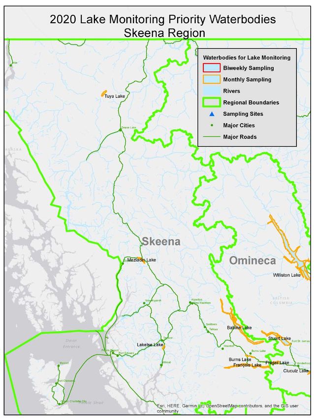
Table 4. Includes the frequency of plankton tow sampling (bi-weekly or monthly) based on the priority ranking
of the waterbody (high or critical). Please refer to Appendix H for detailed maps of the priority waterbodies by
region.
Veliger
Identified Sampling Sites for
Region Waterbody Sampling Lat Long
Select Waterbodies
Frequency
Thompson-Nicola Adams Lake Monthly 51.1891 -119.5807
Lower Mainland Alta Lake Monthly 50.1140 -122.9814
Thompson-Nicola Anderson Lake Monthly 50.6307 -122.3996
Thompson-Nicola Azure Lake Monthly 52.3802 -120.0776
Skeena Babine Lake Monthly 54.7865 -125.9831
Kootenay Baynes Lake Monthly 49.2337 -115.2245
Thompson-Nicola Bonaparte Lake Monthly 51.2617 -120.5584
Thompson-Nicola Bowron Lake Monthly 53.2333 -121.3666
Thompson-Nicola Bridge Lake Monthly 51.5043 -120.7306
Skeena Burns Lake Monthly 54.2028 -125.6611
Cariboo Canim Lake Monthly 51.8493 -120.7649
Kootenay Cedar Lake Monthly 51.2614 -116.9814
Kootenay Champion Lakes Monthly 49.1849 -117.6128
Okanagan Chapman Lake Monthly 49.7833 -120.0339
Peace Charlie Lake Monthly 56.3317 -120.9929
Lower Mainland Chilliwack Lake Monthly 49.0565 -121.4205
Okanagan Christina Lake Biweekly 49.1214 -118.2538
Okanagan Chute Lake Monthly 49.6944 -119.5312
Thompson-Nicola Clearwater Lake Monthly 52.2644 -120.2298
Omineca Cluculz Lake Monthly 53.8796 -123.5779
Kootenay Columbia Lake Biweekly 50.2303 -115.8529
Kootenay Columbia River Nicholson Bridge Monthly 51.2433 -116.9130
Kootenay Columbia River James chabot provincial park Monthly 50.5116 -116.0236
Kootenay Columbia River (Lower) Beaver Creek Provincial Park Monthly 49.0668 -117.6110
Kootenay Columbia River (Lower) Robson Boat Launch Monthly 49.3342 -117.6990
Vancouver Island Cowichan Lake Monthly 48.8729 -124.2628
Okanagan Crooked Lake Monthly 50.0686 -119.1984
Lower Mainland Cultus Lake Monthly 49.0533 -121.9871
Cariboo Deka Lake Monthly 51.6504 -120.7915
Kootenay Dogsleg Lake Monthly 50.6334 -116.2303
Cariboo Dragon Lake Monthly 52.9494 -122.4208
Kootenay Duck Lake Monthly 49.2342 -116.6366
Page | 17DREISSENID MUSSEL FIELD PROTOCOL
Veliger
Identified Sampling Sites for
Region Waterbody Sampling Lat Long
Select Waterbodies
Frequency
Thompson-Nicola Duffy Lake Monthly 50.6533 -120.7074
Kootenays Duncan Lake Monthly 50.4238 -116.9597
Thompson-Nicola Dutch Lake Monthly 51.6519 -120.0559
Thompson-Nicola East Barrière Lake Monthly 51.2770 -119.7939
Vancouver Island Elk Lake Monthly 48.5296 -123.3981
Omineca François Lake Monthly 54.0114 -125.7053
Omineca Fraser Lake Monthly 54.0799 -124.7420
Okanagan Gardom Lake Monthly 50.6035 -119.2010
Thompson-Nicola Green Lake Monthly 51.4070 -121.2138
Peace Gwillim Lake Monthly 55.3519 -121.3177
Peace Haha Lake Monthly 49.4289 -115.4902
Lower Mainland Harrison Lake Monthly 49.5197 -121.8667
Lower Mainland Hatzic Lake Monthly 49.1684 -122.2401
Omineca Hobson Lake Monthly 52.5502 -120.2823
Cariboo Horsefly Lake Monthly 52.4168 -121.0234
Okanagan Jewel Lake Monthly 49.1743 -118.6099
Kootenay Jim Smith Lake Monthly 49.4811 -115.8474
Okanagan Kalamalka Lake Biweekly 50.1728 -119.3273
Thompson-Nicola Kamloops Lake Biweekly 50.7517 -120.6933
Kootenay Kinbasket Lake Mica Creek Biweekly 52.0100 -118.5700
Kootenay Kinbasket Lake Bush harbor Biweekly 51.7568 -117.5760
Kootenay Kinbasket Lake Kinbasket Resort Biweekly 51.5277 -117.4330
Kootenay Kootenay Lake Balfour Biweekly 49.6239 -116.9590
Kootenay Kootenay Lake Lakeside Park Biweekly 49.5088 -117.2810
Kootenay Kootenay Lake Kuskanook Marina wharf Biweekly 49.3003 -116.6630
Cariboo Lac des Roches Monthly 51.4771 -120.5701
Cariboo Lac la Hache Monthly 51.8239 -121.5438
Thompson-Nicola Lac Le Jeune Monthly 50.4805 -120.4782
Kootenay Lake Enid Monthly 50.5482 -116.1237
Kootenay Lake Koocanusa Biweekly 49.1908 -115.2584
Skeena Lakelse Lake Monthly 54.3813 -128.5597
Kootenay Lazy Lake Monthly 49.8249 -115.6228
Thompson-Nicola Leighton Lake Monthly 50.6192 -120.8453
Okanagan Lightning Lake Monthly 49.0495 -120.8414
Kootenay Lillian Lake Monthly 50.5077 -116.0982
Page | 18DREISSENID MUSSEL FIELD PROTOCOL
Veliger
Identified Sampling Sites for
Region Waterbody Sampling Lat Long
Select Waterbodies
Frequency
Lower Mainland Lillooet Lake Monthly 50.2349 -122.5242
Thompson-Nicola Little Shuswap Lake Monthly 50.8503 -119.6463
Kootenay Lower Arrow Lake Scotties Marina wharf Monthly 49.3428 -117.8300
Kootenay Lower Arrow Lake Burton Monthly 49.9930 -117.8870
Okanagan Mabel Lake Biweekly 50.5658 -118.7152
Thompson-Nicola Mara Lake Monthly 50.7726 -119.0161
Skeena Meziadin Lake Monthly 56.0634 -129.3019
Peace Moberly Lake Monthly 55.8207 -121.7654
Kootenay Monroe Lake Monthly 49.3642 -115.8665
Kootenay Moose Lake Monthly 52.9539 -118.9098
Kootenay Moyie Lake Biweekly 49.3474 -115.8327
Thompson-Nicola Murtle Lake Monthly 52.1438 -119.6835
Thompson-Nicola Nadsilnich Lake Monthly 53.7133 -122.8552
Kootenay Nancy Greene Lake Monthly 49.2539 -117.9448
Thompson-Nicola Nicola Lake Monthly 50.1802 -120.5293
Thompson-Nicola Nine Bay Lake Monthly 50.9502 -116.5406
Kootenay Norbury Lakes Monthly 49.5410 -115.4844
Kootenay North Star Lake Monthly 49.3436 -115.2627
Omineca Nukko Lake Monthly 54.0708 -123.0102
Okanagan Okanagan Lake Sandy Beach Campground Biweekly 50.2498 -119.3467
Okanagan Okanagan Lake Okanagan Lake Provincial Park Biweekly 49.7160 -119.7197
Okanagan Okanagan Lake Penticton Marina Biweekly 49.5058 -119.5851
Peace One Island Lake Monthly 55.3073 -120.2939
Okanagan Osoyoos Lake Biweekly 49.0412 -119.4700
Okanagan Otter Lake Monthly 49.5729 -120.7648
Cariboo Palmer Lake Monthly 52.3534 -123.2496
Thompson-Nicola Paul Lake Monthly 50.7399 -120.1155
Thompson-Nicola Pavilion Lake Monthly 50.8653 -121.7380
Kootenay Pend-d'Oreille River Monthly 49.0310 -117.4647
Thompson-Nicola Pennask Lake Monthly 49.9972 -120.1263
Thompson-Nicola Peter Hope Lake Monthly 50.2935 -120.3172
Thompson-Nicola Pillar Lake Monthly 50.5935 -119.6395
Lower Mainland Pitt Lake Monthly 49.4340 -122.5601
Kootenay Premier Lake Biweekly 49.9365 -115.6537
Omineca Purden Lake Monthly 53.9195 -121.9070
Page | 19DREISSENID MUSSEL FIELD PROTOCOL
Veliger
Identified Sampling Sites for
Region Waterbody Sampling Lat Long
Select Waterbodies
Frequency
Cariboo Quesnel Lake Monthly 52.5597 -120.9835
Kootenay Revelstoke Lake Biweekly 51.5089 -118.4508
Thompson-Nicola Roche Lake Monthly 50.4746 -120.1522
Kootenay Rosebud Lake Monthly 49.0475 -117.2673
Kootenay Rosen Lake Monthly 49.3997 -115.2569
Vancouver Island Shawnigan Lake Monthly 48.6304 -123.6381
Cariboo Sheridan Lake Monthly 51.5161 -120.8944
Thompson-Nicola Shumway Lake Monthly 50.5253 -120.2531
Thompson-Nicola Shuswap Lake Sandy Point Biweekly 50.7295 -119.3040
Thompson-Nicola Shuswap Lake Old Town Bay Biweekly 50.8497 -119.0130
Thompson-Nicola Shuswap Lake Cinnamousin Narrows Biweekly 50.9986 -119.0130
Thompson-Nicola Shuswap Lake Anglemont Biweekly 50.9634 -119.1730
Thompson-Nicola Shuswap Lake Little River Boatworld Biweekly 50.8828 -119.5520
Thompson-Nicola Shuswap Lake Blind Bay Biweekly 50.8870 -119.3977
Okanagan Skaha Lake Biweekly 49.4101 -119.5854
Kootenay Slocan Lake Biweekly 49.9359 -117.4225
Vancouver Island Sproat Lake Monthly 49.2662 -125.0270
Kootenay St. Mary Lake Monthly 49.6100 -116.1930
Omineca Stuart Lake Monthly 54.5533 -124.6326
Okanagan Sugar Lake Monthly 50.4012 -118.5156
Thompson-Nicola Sullivan Lake Monthly 50.9664 -120.1180
Kootenay Summit Lake Monthly 54.2887 -122.6799
Kootenay Surveyors Lake Monthly 49.2458 -115.2357
Kootenay Suzanne Lake Monthly 49.3207 -115.2393
Kootenay Swalwell Lake Monthly 50.0532 -119.2309
Peace Swan Lake Monthly 55.5182 -120.0151
Omineca Tabor Lake Monthly 53.9164 -122.5422
Kootenay Tie Lake Biweekly 49.4149 -115.3185
Kootenay Trout Lake Monthly 50.5851 -117.4367
Okanagan Tugulnuit Lake Monthly 49.1983 -119.5405
Skeena Tuya Lake Monthly 59.0779 -130.5767
Kootenay Upper Arrow Lake Shelter bay Biweekly 50.6372 -117.9240
Kootenay Upper Arrow Lake Nakusp boat launch Biweekly 50.2363 -117.7980
Kootenay Wasa Lake Monthly 49.7797 -115.7354
Kootenay Whatshan Lake Monthly 50.0186 -118.1022
Page | 20DREISSENID MUSSEL FIELD PROTOCOL
Veliger
Identified Sampling Sites for
Region Waterbody Sampling Lat Long
Select Waterbodies
Frequency
Thompson-Nicola White Lake Monthly 50.8826 -119.2644
Kootenay Whiteswan Lake Biweekly 50.1415 -115.4823
Kootenay Whitetail Lake Monthly 50.2140 -116.0259
Cariboo Williams Lake Monthly 52.1154 -122.0696
Omineca Williston Lake Monthly 56.0685 -122.8769
Kootenay Windermere Lake Biweekly 50.4591 -115.9890
Okanagan Wood Lake Biweekly 50.0817 -119.3898
Omineca Yellowhead Lake Monthly 52.8547 -118.5687
Page | 21DREISSENID MUSSEL FIELD PROTOCOL
LITERATURE AND SOURCES
Arizona Game and Fish Department Aquatic Invasive Species Decontamination Protocols
Bureau of Reclamation Technical Service Center, Reclamation Detection Laboratory for Invasive and
Native Species. Field Protocol: Field Preparation of Water Samples for Dreissenid Veliger
Detection.
Bureau of Reclamation Technical Service Centre Reclamation Detection Laboratory for Invasive and
Native Species. Impact of Sample Preservation on Detection of Invasive Mussels.
California Department of Fish and Wildlife. 2017. Quagga/Zebra Mussel Artificial Substrate Monitoring
Protocol. https://nrm.dfg.ca.gov/FileHandler.ashx?DocumentID=4953&inline
Colorado Department of Natural Resources, Colorado Parks And Wildlife State Invasive Species Program,
Aquatic Nuisance Species Sampling and Monitoring Protocol
Minnesota Aquatic Invasive Species Research Center, University of Minnesota (MAISRC) and the
Minnesota Department of Natural Resources (DNR). Monitoring for zebra mussels
Portland State University, Wells, S. and Sytsma, M. 2015. Sample Collection Protocols Zebra and Quagga
Mussel Early Detection Monitoring
State of Wisconsin Department of Natural Resources Wisconsin Lakes Partnership. Dreissenid (Zebra and
Quagga) Mussel Monitoring Protocol
Therriault, T.W., Weise, A.M., Higgins, S.M., Guo, S. and J. Duhaime. 2012. Risk assessment for three
Dreissenid mussels (Dreissena polymorpha, Dreissena rostriformis bugensis, and Mytilopsis
leucophaeata) in Canadian freshwater ecosystems. DFO Can. Sci. Advis. Sec. Res. Doc. 2012/174 v
+ 88 p
University of Illinois. 2007.Standard Protocols For Monitoring And Sampling Zebra Mussels
Water on the Web. 2011. Glossary. http://www.waterontheweb.org/resources/glossary.html
Wells, S, Counihan, T.D., Puls, A, Sytsma, M., and B. Adair. 2010. Prioritizing zebra and quagga mussel
monitoring in the Columbia River Basin. Prepared for Bonneville Power Administration and the
Pacific States Marine Fisheries Commission. Portland State University, Portland, OR, United States
Geological Survey, Western Fisheries Research Center, Cook, WA.
Wells, S. W. and M. Sytsma. 2015. "Zebra and Quagga Mussel Early-Detection Monitoring in High Risk
Oregon Waters 2014". Center for Lakes and Reservoirs Publications and Presentations. Paper 32.
http://pdxscholar.library.pdx.edu/centerforlakes_pub/32
Western Regional Panel 2018. Minimum Monitoring Guidance For Utilizing Plankton Tows For The
Detection Of Dreissenid Veligers. Standard Operating Procedure.
Page | 22DREISSENID MUSSEL FIELD PROTOCOL
APPENDIX A: REPORTING INFORMATION
Conservation Data Center:
https://www2.gov.bc.ca/gov/content/environment/plants-animals-ecosystems/conservation-data-
centre/submit-data
Email: cdcdata@gov.bc.ca
Invasive species information and factsheets:
www.gov.bc.ca/invasive-species
Reporting Information:
Immediately report any suspected invasive mussels to the Report All Poachers and Polluters Hotline: 1-
877-952-7200 (RAPP)
Ministry of Environment and Climate Change Strategy (ENV) contact:
Cassandra Silverio, Aquatic Invasive Species Specialist
Email: Cassandra. Silverio@gov.bc.ca
Or
Martina Beck, Invasive Fauna Unit Head
Email: Martina.Beck@gov.bc.ca
Habitat Conservation Trust Foundation (HCTF) grant application information:
https://hctf.ca/apply-for-funding/invasive-mussel-monitoring/
Analytical Lab:
The chain of custody (COC) form and shipping information for the lab will be provided by BC ENV staff at
the start of the respective sampling season. The COC form must be sent to both the lab and the ENV
contact above when shipping samples.
Page | 23DREISSENID MUSSEL FIELD PROTOCOL
Appendix B: Equipment for plankton tows
• Plankton net (simple, conical plankton-tow net, 64 um pore size, recommended 0.5 m diameter net
opening, but 0.3 m is also acceptable, removable weighted cod-end piece);
• Line for deploying the net (about 20m) with 1 meter interval markings;
• Sample container (preferably polyethylene material, 250 to 500 mL volume, screw lid; but any leak-
proof container suitable for shipping can be used);
• Preservative (95% regular ethanol or 99% isopropyl alcohol);
• 5% Baking soda
• Squirt Bottle
• Field sheets and pen/ pencils;
• Waterproof labels (write in the rain paper);
• Thermometer;
• Permanent marker;
• GPS unit (recommended);
• Tweezers or small spatula (recommended);
• Boat (recommended);
• pH strips or pen meter
• Secchi disk
• Measuring tape or ruler (optional)
Page | 24DREISSENID MUSSEL FIELD PROTOCOL
Appendix C: Vertical Plankton Tow
1. Secure the cod-end piece and check that the line is securely attached to the plankton net.
Secure the other end of the line to the boat.
2. Lower the net to planned sampling depth (see Table 2). For waterbodiesDREISSENID MUSSEL FIELD PROTOCOL
Appendix D: Horizontal Plankton Tow
Horizontal tow from a boat:
1. A weight (1-2 kg or 2-4 lbs) is attached to the rope immediately in front of the net opening to
keep the net below the water surface.
2. To determine the depth, subtract the length of your plankton net, plus minimum .5 meters off
the bottom to avoid fouling the net/sample.
3. The net is thrown into the water and allowed to sink to no more than 1 m above the bottom and
keep at consistent depth.
4. Record the start time and the starting location coordinates on field datasheet. Record the
distance that the net is towed through the water.
5. Use the boat engines and/or the river current to move the net horizontally through the water
for three to 5 minutes (depends on boat speed, net mouth opening, eutrophic status of the
waterbody), or slowly pull the net back to you at a slow and steady rate as described above (the
total length of the tow can be determined using the graduation marks on the tow rope). The
tow should be done at low speeds, e.g., 0.5 to 3-Km/h. The boat may be driven directly
upstream, essentially keeping the boat in the same approximate longitudinal position and
allowing river to flow through net. Trawling can also be done transversely to the current. Reduce
the trawling time in productive and turbid waters as net may clog. Keep the net off the bottom
to avoid both snagging and collecting debris.
6. Idle or stop the boat engine and manually retrieve the net using a hand-over-hand technique at
a rate of 0.5-m/s. Your goal is to pull the net on a diagonal path from bottom to top, sampling as
much of the water column as possible without letting the net or cod end hit the bottom.
7. Record the stop time, boat speed and the coordinates of the stop location on the COC/field
datasheet (Appendix B). The trawling time and boat speed are used to estimate the volume of
water filtered (i.e., distance = rate x time).
8. Repeat techniques used for vertical plankton tows to concentrate organisms into the cod end of
the net.
9. Follow the procedure outlined in Appendix F for preserving the sample and Appendix G for
labeling the sample.
Flow Rate Plankton Net Plankton Net
(m/s) Diameter (50 cm) Diameter (30 cm)
0.5 33 93
1.0 17 46
1.5 11 31
2.0 8 23
2.5 7 19
3.0 6 16
Page | 26DREISSENID MUSSEL FIELD PROTOCOL
Horizontal Tow from a Dock
1. If conducting horizontal plankton tow from a dock, lower the net and allow the net to sink into
the water to within 0.5‐1m of the bottom. Your goal is to pull the net on a diagonal path from
bottom to top, sampling as much of the water column as possible without letting the net or cod
end hit the bottom. If an air bubble gets trapped in the net, retrieve the net and start again.
2. If possible avoid sampling in aquatic vegetation, but if it is a high use/high boat traffic site
sampling should still be conducted.
3. Follow steps 5-8 in Appendix C to concentrate organisms into the cod end of the net. Record
length of each tow, and number of tows.
4. Follow the procedure outlined in Appendix F for preserving the sample and Appendix G for
labeling the sample.
Shoreline Toss
When a boat is not available or when you are sampling from a dock or other land structures then a
shoreline toss can be used.
1. Remove the net anchor, which is secured to a loop in net rope.
2. Screw on the weighted cod end, check that the hose clamp is secure, and that the net rope is
secured to steel ring.
3. Hold the net ring using thumb and forefinger of your throwing hand. Make large loops of the net
rope and hold loosely with the same hand holding the net. Grasp the loops of the rope in front
of the net opening.
4. Firmly hold the other end of the rope with free hand.
5. Throw the net using a sidearm-style, opening your hand upon release to allow rope to feed out
with the net.
6. Allow the net to sink into water body. A weighted cod end will aid in pulling the net into the
water. If an air bubble gets trapped in the net, retrieve the net and start again.
7. Manually retrieve the net using a hand over hand technique at a rate of 0.5-m/s (1.5-ft/s). Keep
the net off the sediment to avoid both snagging and collecting debris.
8. Repeat techniques used for vertical plankton tows to concentrate organisms into the cod end of
the net.
9. Follow the procedure outlined in Appendix F for preserving the sample and Appendix G for
labeling and shipping of the samples.
Page | 27DREISSENID MUSSEL FIELD PROTOCOL
APPENDIX E: ARTIFICIAL SUBSTRATE SAMPLERS
Either a Portland sampler or a plate sampler can be used for substrate monitoring. This section provides
the instructions and materials needed to build both types of samples.
Portland Sampler:
Materials needed
• 13mm diameter plastic construction mesh or plastic gutter guard (x3 17cm wide strips)
• 17cm white PVC pipe (5cm diameter) x 2
• 17 cm black PVC pipe (5 cm diameter) x2
• 500g concrete anchor
• 4 large flat washers
• Rope (nylon or paracord, do not use polypropylene plastic rope as it will degrade over time)
Portland Sampler Construction:
1. Cut the rope to the appropriate length for the depth of the sample site. At the end of
the rope tie a small (500g) concrete anchor at the bottom.
2. Cut the white and black PVC pipe (5-cm diameter) into 17cm pieces. The PVC pipe
sections will be placed 2ft apart along the length of the rope, so the exact number of
PVC pieces will depend on the length of the rope but should be around 3-4 per substrate
sampler (2 white and 2 black).
3. In the middle of the 17cm PVC pieces drill two holes 7mm wide (at the opposite sides of
the pipe) this will be for feeding the rope through. Repeat the same with the black PVC
pipe with the same dimensions. Sand down the edges of the holes to make a smooth
surface.
4. On the other side of the PVC pipe drill three 7mm wide holes at equal distance across
the length of the 17cm PVC section. Sand down the edges of the holes to make a
smooth surface. These holes provide additional surface area for dreissenid mussel to
settle on. Nothing will be thread through these holes (see Figure below).
5. Cut the plastic mesh into 17 cm wide strips (the number of strips will depend on the
length of the rope).
6. First thread a large flat washer followed by the first 17cm piece of white PVC pipe to the
bottom of the rope just above the secured anchor. Thread another large flat washer just
above the first pipe section. Weave the plastic mesh strip lengthwise through the rope
just above the flat washer and the first pipe section see Figure below).
7. About 2 ft above the top of the first PVC pipe section tie a knot in the rope and thread a
flat washer through the rope so it sits just above the knot.
8. Repeat steps 5 and 6 until all the PVC pipe sections and plastic mesh sections have been
thread through the full length of the rope section with 2ft spacing between each PVC
pipe-mesh section. Alternate between black and white PVC pipe along the rope section.
Page | 28You can also read