CAPRICE TO COMMENCE MAJOR EXPANSIONARY RC DRILL PROGRAM AT THE ISLAND GOLD PROJECT - AFR
←
→
Page content transcription
If your browser does not render page correctly, please read the page content below
ASX RELEASE | 12 July 2021 | ASX:CRS

       CAPRICE TO COMMENCE MAJOR EXPANSIONARY RC DRILL
              PROGRAM AT THE ISLAND GOLD PROJECT
SUMMARY

    RC drilling is due to commence at the Island Gold Project this week
    The 8,500m program will systematically test multiple new targets, as well as extensions to
    existing mineralisation, all of which are located on the Island
    A detailed gravity survey has significantly improved the understanding of the geology and
    structures of the Island Gold Project
    Numerous north-west striking structures have been identified, which may be associated
    with mineralisation, as evidenced by neighbouring Musgrave Minerals Ltd recent drilling
    success (See ASX MGV announcement 30 June 2021)
    The structural interpretation will also help fine tune the pending Lake Austin focussed
    aircore program, which will commence following the completion of the RC program
Caprice Resources Ltd (ASX: CRS) (“Caprice” or “the Company”) is pleased to provide an
exploration update on the Island Gold Project, located in the Murchison region of Western
Australia.

Caprice will commence an 8,500m RC drilling program at the Island Gold Project (IGP). The program will
be located entirely on the Island portion of the Project and will be testing multiple new targets, as well
as extensions to previously identified mineralisation.

Some of the targets are associated with north-west striking structures, identified from the recent gravity
survey. Such north-west structures may control mineralisation, as recently identified by Musgrave
Minerals Ltd on tenements immediately to the west of the IGP.

Following the RC program, a large aircore program will test the 75% of the IGP that is covered by Lake
Austin. This area has had no previous drilling of note due to the lake cover, yet it has a high degree of
structural complexity which enhances its prospectivity.

Managing Director, Andrew Muir, commented:

“This RC program is the first step in our expansionary exploration strategy testing for new mineralisation.
The IGP has already demonstrated its high-grade nature, and we are optimistic of delineating new
mineralised areas on the Island.

The gravity survey has enabled the refinement of our interpretation of the IGP structural regime. This has
significantly improved target identification, not only on the Island, but also under Lake Austin. We will
progressively test these targets, starting with RC drilling on the Island this week, and then the aircore drill
program on Lake Austin.”

                                                                                   CAPRICERESOURCES.COM.AU
                                                                          3 Ord Street, West Perth WA 6005 Australia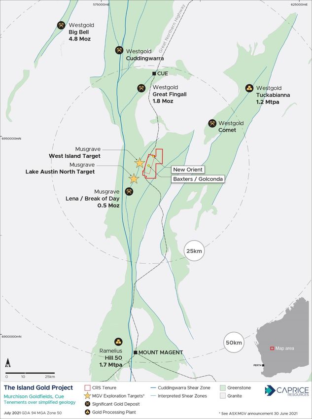
ASX RELEASE | 12 July 2021 | ASX:CRS

                   CAPRICERESOURCES.COM.AU
          3 Ord Street, West Perth WA 6005 Australia
2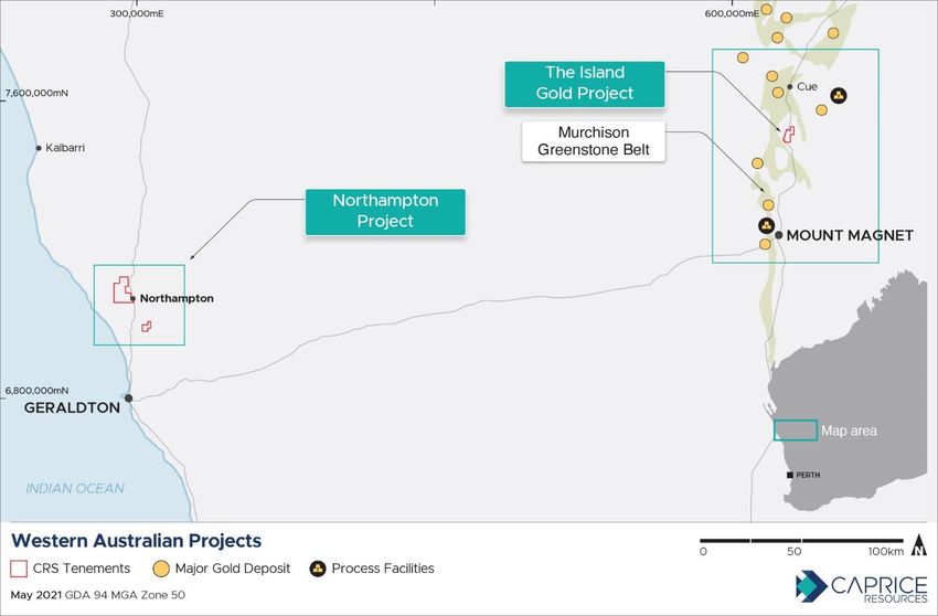
ASX RELEASE | 12 July 2021 | ASX:CRS
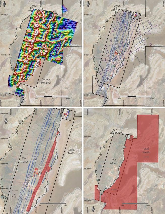
Gravity Data for Survey Interpreted
Completed to Date Structures and
(Tilt Derivative of Bouguer Simplified
Anomaly Geology
RC Drilling Areas Aircore Drilling
(Red Shading) Area
(Red Shading)
CAPRICERESOURCES.COM.AU
3 Ord Street, West Perth WA 6005 Australia
3ASX RELEASE | 12 July 2021 | ASX:CRS
For further information please contact:
Andrew Muir
Managing Director
amuir@capriceresources.com
About Caprice Resources
Caprice Resources Limited (ASX: CRS) holds a 100% interest in the Island Gold Project, located in the Lake Austin
gold mining centre in the Cue Goldfield. The Project comprises two granted mining leases and one exploration
license (M21/66, M21/140 and E21/186) covering the New Orient, The Island and North Island properties. Caprice
acquired the Project in October 2020 and undertook its maiden drill campaign in November 2020, confirming
multiple high-grade gold targets that are being systematically explored.
The Company also holds a 100% interest in the Northampton Project, a polymetallic brownfields project
surrounding historical lead-silver and copper mines that were operational between 1850 and 1973. Caprice also
hold a 100% interest in the Wild Horse Hill Gold Project located within the Pine Creek province of Northern
Territory.
CAPRICERESOURCES.COM.AU
3 Ord Street, West Perth WA 6005 Australia
4ASX RELEASE | 12 July 2021 | ASX:CRS
Competent Person’s Statement
The information in this report that relates to exploration results has been compiled by Mr Christopher Oorschot, a
full time employee of Caprice Resources Ltd. Mr Oorschot is a Member of the Australian Institute of Geoscientists
and has sufficient experience in the style of mineralisation and type of deposit under consideration and the activity
being undertaken to qualify as a Competent Person as defined in the 2012 Edition of the Australasian Code for
Reporting of Exploration Results, Minerals Resources and Ore Reserves (“JORC Code”). Mr Oorschot consents to
the inclusion in the report of the matters based on the information in the form and context in which it appears.
APPENDIX I
JORC Code, 2012 Edition:
Section 1: Sampling Techniques and Data
(Criteria in this section apply to all succeeding sections.)
Criteria JORC Code explanation Commentary
Sampling • Nature and quality of sampling (e.g. cut • Caprice Resources Ltd (CRS) sampling is conducted using
techniques channels, random chips, or specific standard industry practices including the use of duplicates,
specialised industry standard blanks and standards at regular intervals. The performance of
measurement tools appropriate to the QAQC controls is monitored on a batch-by-batch basis.
minerals under investigation, such as • For CRS and Goldview Metals Pty Ltd (Goldview), reverse
down hole gamma sondes, or handheld circulation drilling was used to obtain 1m samples that were split
XRF instruments, etc). These examples directly from the cyclone via an onboard cone splitter. Samples
should not be taken as limiting the broad weights were monitored and noted by the supervising geologist.
meaning of sampling. Bulk samples for each metre drilled are stored in green bags and
• Include reference to measures taken to retained on site until all results are received and pass QAQC
ensure sample representivity and the protocols.
appropriate calibration of any • The condition of sampled materials was monitored by the
measurement tools or systems used. supervising geologist and any variation was recorded with the
• Aspects of the determination of sample data.
mineralisation that are Material to the • Collected samples range between 0.5kg to 4kg, averaging 2.6kg.
Public Report. The sample size is deemed appropriate for the grain size of the
• In cases where ‘industry standard’ work material being sampled. Analysed samples were crushed and
has been done this would be relatively pulverised to 85% passing -75um, homogenised and split to
simple (e.g. ‘reverse circulation drilling produce a 50g lead charge for Fire Assay with MP-AES
was used to obtain 1 m samples from (Microwave Plasma Atomic Emission Spectroscopy) finish for Au
which 3 kg was pulverised to produce a at SGS Laboratories. This analytical method has a detection limit
30 g charge for fire assay’). In other of 0.01ppm.
cases more explanation may be required, • For historic drilling, Diamond Drilling (DD), Reverse Circulation
such as where there is coarse gold that (RC) and Air Core / Rotary Air Blast (AC/RAB) methods have
has inherent sampling problems. been used. The nature and quality of sampling varies according
Unusual commodities or mineralisation to the exploration company and drilling equipment used. Sample
types (e.g. submarine nodules) may quality from historic drilling is considered suitable for the
warrant disclosure of detailed delineation of exploration targets, identifying the presence or
information. absence of mineralisation, and informing exploration level
models. Historic drilling results will not be included in the
calculation of Mineral Resource estimates.
• For ground gravity data, surveys were completed by Haines
Surveys Pty. Ltd. Station measurements were taken using a
Scintrex CG5 Autograv.
Drilling techniques • Drill type (e.g. core, reverse circulation, • For CRS and Goldview, RC drilling was completed by NDRC
open-hole hammer, rotary air blast, Drilling Pty Ltd, using a Schramm 64 truck mounted rig with
auger, Bangka, sonic, etc) and details Sullair 350/900 cfm on-board compressor, augmented with a
(e.g. core diameter, triple or standard 1800cfm auxiliary Air Truck mounted with an Ingersoll Rand
tube, depth of diamond tails, face- 350/1070 cfm compressor coupled to a 2010 Air Research
sampling bit or other type, whether core Booster compressor capable of 900 psi @ with. RC holes were
is oriented and if so, by what method, drilled with a 5 1/4-inch diameter face sampling bit.
CAPRICERESOURCES.COM.AU
3 Ord Street, West Perth WA 6005 Australia
5ASX RELEASE | 12 July 2021 | ASX:CRS
Criteria JORC Code explanation Commentary
etc). • For Browns Creek Gold Ltd (1987-1988), historic RAB drilling
was conducted using a Gemco H22 multipurpose rig with 750
cfm / 300 psi air compressor, using a 112mm face sampling bit.
• For historic drilling completed by CSR Limited (1992-1993), an
Atlas Copco Rotomec with a 750cfm / 300psi capacity
compressor using 5.5-inch rods and hammer. For Diamond
Drilling completed by CSR Limited (1992-1993), a VK600 top
drive with NQ size bit / rods was used.
• For historic drilling completed by Golconda Exploration Ltd Pty,
from 1988-1989, a Wallis rig mounted on a Toyota Landcruiser
with a 75mm AC bit, 3m rods and 160 cfm / 150 psi compressor
was utilised. Between 1993-1994, for RC drilling the contractor
Stanley Drilling was engaged for drilling services, using an
Edson 3000 (unknown hole diameter). Between 1994-1995 for
AC/RAB drilling contractor A & J Drilling was engaged for drilling
services using a truck mounted Warman Mark 5 was also used
for AC/ RAB drilling (unknown bit diameter).
• For historic drilling completed by Pinnacle Mining NL (1994-
1995), AC drilling contractor Connector Drilling was engaged for
drilling services, equipment specifications were not recorded.
Drill sample • Method of recording and assessing core • For CRS drilling, sample weights, dryness and recoveries are
recovery and chip sample recoveries and results observed and recorded with sample data by the supervising
assessed. geologists.
• Measures taken to maximise sample • For CRS drilling, samples were weighed at the laboratory to
recovery and ensure representative allow comparative analysis between submitted sample weight
nature of the samples. and grade.
• Whether a relationship exists between • For historic RC and AC drilling, recoveries have not been
sample recovery and grade and whether recorded, in some instances geological logs will note intervals of
sample bias may have occurred due to poor recovery.
preferential loss/gain of fine/coarse • For historic diamond drilling, core recoveries were noted as
material. being 100%.
• CRS contracted drillers use industry appropriate methods to
maximise sample recovery and minimise downhole
contamination.
• No significant sample grade bias associated with sample
recovery has been noted in previous drilling or in drilling
conducted by CRS.
Logging • Whether core and chip samples have • For CRS RC drilling, the logging of lithology, structure, alteration,
been geologically and geotechnically mineralisation, veining, weathering, colour and any other
logged to a level of detail to support observable features is undertaken at 1m intervals.
appropriate Mineral Resource estimation, • For CRS drilling, a portion of each 1m interval of RC cuttings is
mining studies and metallurgical studies. sieved and cleaned then retained in chip trays as a visual
• Whether logging is qualitative or reference for logging. Chip trays are labelled with the relevant
quantitative in nature. Core (or costean, hole ID, drill depths and individual intervals. Chips trays are
channel, etc) photography. catalogued and stored in Perth and readily available for review.
• The total length and percentage of the • All drill holes are logged in full.
relevant intersections logged. • For historic DD, RC and AC drilling, the primary lithology and/or
weathering has been recorded for the full length of all drill holes.
Sub-sampling • If core, whether cut or sawn and whether • There are 8 historic diamond holes across the Island Gold
techniques and quarter, half or all core taken. Project completed between 1982 and 1983 by CSR Limited. The
sample preparation • If non-core, whether riffled, tube sample method and portion of core sampled is unknown. No
sampled, rotary split, etc and whether portion of the drilled core is retained by CRS.
sampled wet or dry. • For historic diamond drilling, NQ diameter core of variable
• For all sample types, the nature, quality sample lengths were submitted for analysis. Sample lengths
and appropriateness of the sample were based on lithological contacts, alteration and mineralisation
preparation technique. contacts. Core recovery is described as excellent with 100%
• Quality control procedures adopted for all recovery.
sub-sampling stages to maximise • For CRS RC samples, 1m intervals were split via a cone splitter
samples representivity directly from the cyclone. Samples are predominantly dry, wet
• Measures taken to ensure that the samples are noted within sample records.
sampling is representative of the in-situ • For CRS RC sampling, rig duplicates are taken at a frequency of
material collected, including for instance 1 for every 20 conventional sample (1:20); standards are
results for field duplicate/second-half inserted into the sample stream at a rate of 1 standard for every
sampling. 20 conventional samples (1:20); and blanks are inserted into the
• Whether sample sizes are appropriate to sample stream at a rate of 1 standard for every 20 conventional
the grain size of the material being samples (1:20). Conventional samples were taken directly off the
CAPRICERESOURCES.COM.AU
3 Ord Street, West Perth WA 6005 Australia
6ASX RELEASE | 12 July 2021 | ASX:CRS
Criteria JORC Code explanation Commentary
sampled. rig mounted cone splitter, which is fed directly from the cyclone.
If insufficient sample is received in the split, additional sample
material will be added using the retained 1m bulk sample stored
in a green bag.
• For CRS samples, sample preparation and Au analysis is
undertaken by a registered laboratory (SGS Laboratories).
Sample preparation by dry pulverisation to 85% passing 75
microns is monitored with pass rates recorded at regular
intervals as part of the labs reporting process. Pass rates are
monitored on a batch-by-batch basis as part of QAQC
conventions.
• For historic RC and Air Core (AC) drilling a combination or 1m
samples and composited samples (between 2m to 6m
composites). Samples were collected via a combination of riffle
splitter and metals scoops / spears.
• QAQC procedures for historic DD, RC and AC drilling is not
recorded. It is assumed industry standards QAQC protocols for
the time were applied.
• Several historic holes have been twinned with RC drilling by
either Goldview or CRS. Results mostly confirm the tenure and
location of historic intercepts.
• Sample sizes for both CRS and Goldview drilling are considered
appropriate for grain size of the sampled material to give an
accurate indication of gold mineralisation. Samples are collected
across the full width of the drilled interval to ensure it is
representative.
Quality of assay • The nature, quality and appropriateness • For CRS and Goldview 1m RC samples, Au analysis is
data and laboratory of the assaying and laboratory undertaken by SGS Laboratories (a registered laboratory), with
tests procedures used and whether the 50g fire assay with MP-AES. This method has a detection limit of
technique is considered partial or total. 0.01ppm. This is a full digestion technique.
• For geophysical tools, spectrometers, • Historic drilling utilised a similar preparation and Fire Assay
handheld XRF instruments, etc, the analysis method to CRS, (either 20 or 50g lead charge fire
parameters used in determining the assay) through reputable labs of the time. For some historic
analysis including instrument make and drilling and sampling, copies of the original lab reports citing the
model, reading times, calibrations factors method and detection limits are retained by CRS. Where original
applied and their derivation, etc. lab reports are not available assays have been extracted from
• Nature of quality control procedures copies of historic logging sheets where assay results (including
adopted (e.g. standards, blanks, the detection limit) have been recorded / transcribed by hand
duplicates, external laboratory checks) onto the logging sheet.
and whether acceptable levels of • For CRS samples, Internal certified laboratory QAQC is
accuracy (i.e. lack of bias) and precision undertaken including check samples, repeats, blanks and
have been established. internal standards.
• No external laboratory checks have been completed.
• Detection limits and techniques are appropriate for the detection
of Au mineralisation in the materials analysed.
• For ground gravity data:
o A survey and gravity base station was established for the
project with good UHF radio coverage for the RTK survey
system. The same station has been used for all surveys
completed.
o Horizontal and vertical spatial control has been
established using the AUSPOS online GPS processing
service provided by Geoscience Australia. This method
provides control within the GDA94 Datum to within +/- 5
cm.
o Gravity control for 2020.1001 base station was established
on the Australian Absolute Gravity Datum 2007 (AAGD07)
using a one-way tie from Wongan Hills Isogal 12999609
with two gravity meters. A check tie using classical A-B-A
ties from gravity station 2018.2199 was also made. The
values for 2018.2199 were attained from Haines Surveys
Pty. Ltd. archives. All completed gravity ties ensured that
Gravity Control was established to within 0.01 milligals.
o Base station readings were taken at the beginning of the
day and at the end of the day’s fieldwork.
o Carrier phase GPS data has been collected using Trimble
R8 GNSS series geodetic receivers Measurements to
existing control have been made using Static techniques.
All static baselines have been processed to double
CAPRICERESOURCES.COM.AU
3 Ord Street, West Perth WA 6005 Australia
7ASX RELEASE | 12 July 2021 | ASX:CRS
Criteria JORC Code explanation Commentary
difference fixed solutions resulting in horizontal and
vertical precision of approximately 2 cm.
o Measurements for detail gravity observations have been
made using Real Time Kinematic (RTK) techniques giving
horizontal and vertical precision of at least 5 cm. Static
baseline and RTK processing has been done using
Trimble Business Centre Version 2.50 software.
o Gravity measurements have been made using Scintrex
CG5 Autograv instruments Readings of 120 seconds were
taken at base station. Readings of 40 seconds were taken
at all other gravity survey points. All Autograv instruments
apply an instrument drift correction to its final gravity
reading. Any residual drifts between base station readings
are corrected by the gravity post processing software. The
instruments also apply Earth Tide Corrections to their final
gravity reading at each station. The various instrument
calibration constants are contained in the daily gravity data
files. a 1 in 20 stations were repeated for quality control.
o The processing of the gravity data was completed using
standard formulae and constants as documented by
Geoscience Australia to produce Bouguer Anomaly for
each gravity station.
o The meter reading as recorded in the raw Scintrex data file
is corrected for instrument tilts, meter drift and Earth Tide.
Post processing corrections are detailed below.
Verification of • The verification of significant • CRS RC samples are verified by the supervising geologist
sampling and intersections by either independent or before importing into the database. Significant intercepts are
assaying alternative company personnel. reviewed by CRS geologists including a visual review of RC
• The use of twinned holes. chips and a spatial review of the results relative to adjacent
• Documentation of primary data, data drilling.
entry procedures, data verification, data • A number of historic RC holes have previously been twinned by
storage (physical and electronic) CRS or Goldview. Twinned RC holes were completed to validate
protocols. historic intercepts where the exact location of holes could not be
• Discuss any adjustment to assay data. identified or verified in the field.
• For CRS drilling, primary data is collated using a standard set of
templates. Geological logging of 1m intervals is undertaken for
all RC drilling with lithology, colour, weathering, structure,
alteration, veining and mineralisation recorded for each interval.
Data is verified before loading into a database. Geological
logging of all samples / intervals is undertaken in the field by a
qualified and experienced supervising geologist.
• Assay data is reported without adjustments or calibrations. For
all intercepts, the first received assay result is always reported.
• Intercepts have been calculated using a 0.5 g/t Au cut-off and
may include up to 2m of internal waste. Intercepts with a length
weighted average greater than 0.5g/t Au have been reported.
Location of data • Accuracy and quality of surveys used to • The collar location of all RC holes completed by CRS have been
points locate drill holes (collar and down-hole surveyed using a DGPS with a precision of +/- 0.1m.
surveys), trenches, mine workings and • All CRS RC drilling is down hole surveyed using a north seeking
other locations used in Mineral Resource gyro with an azimuth and dip reading accuracy of 0.25ᵒ. Survey
estimation. measurements are taken every 30m down hole, and a final
• Specification of the grid system used. reading is taken at the bottom of the completed drill hole.
• Quality and adequacy of topographic • Previous drilling completed by Goldview was surveyed by a
control. handheld GPS with an accuracy of +/- 2m.
• Historic Drilling was located using a local grid, historic drilling
collars are accurate to with +/- 10m. In some instances, historic
collars have been identified in the field and resurveyed by either
handheld GPS or DGPS.
• For historic drilling, down hole survey methods and data was not
documented. When plotting historic drilling in 3D space the
planned or surface orientation of the historic hole is used.
• No JORC compliant Mineral Resources Estimates have been
reported for the IGP. Historic drilling data will not be used to
inform any future Mineral Resource Estimates.
• All maps and locations are presented and referenced using MGA
UTM grid (GDA94 Z50).
CAPRICERESOURCES.COM.AU
3 Ord Street, West Perth WA 6005 Australia
8ASX RELEASE | 12 July 2021 | ASX:CRS
Criteria JORC Code explanation Commentary
• Surface heights are validated against a surface DTM generated
from 5m by 40m spaced spot heights taken during airborne
magnetic surveys.
• For Gravity data, station location has been collected using
Trimble R8 GNSS series geodetic receivers. Measurements to
existing control have been made using Static techniques. All
static baselines have been processed to double difference fixed
solutions resulting in horizontal and vertical precision of
approximately 2 cm. Data locations were surveyed relative to
UTM GDA 94 Z50.
Data spacing and • Data spacing for reporting of Exploration • Variable drill holes spacing have been utilised across the Island
distribution Results. Gold Project. DH spacing therefore vary between 5m to 40m
• Whether the data spacing and across various projects.
distribution is sufficient to establish the • No resource estimates have been reported.
degree of geological and grade continuity
appropriate for the Mineral Resource and
Ore Reserve estimation procedure(s)
and classifications applied.
Orientation of data • Whether the orientation of sampling • Where possible, drilling was designed to test mineralisation at an
in relation to achieves unbiased sampling of possible orientation that is orthogonal to the interpreted orientation of
geological structure structures and the extent to which this is mineralisation. Access restrictions and mitigating safety risks
known, considering the deposit type. may require holes to be drilled at an orientation that is not
• If the relationship between the drilling orthogonal to the orientation of mineralisation. Where the
orientation and the orientation of key orientation of mineralisation is uncertain, varied drill hole
mineralised structures is considered to orientations have been applied in order to triangulate the
have introduced a sampling bias, this orientation, and/or confirm the interpreted orientation.
should be assessed and reported if • Most historic and CRS RC drill holes were drilled at a dip of
material. approximately -60 degrees.
• No orientation-based sampling bias has been observed at this
time. A range of drilling directions / orientations have been
utilised for exploration drilling by Goldview Metals Ltd Pty.
• For all prospects, the true width of mineralisation is not yet
known.
Sample security • The measures taken to ensure sample • Chain of custody is managed by CRS staff or consultants.
security. Samples were transported by a commercial courier direct from
the Island Gold Project to the Laboratory. When samples arrive
at the laboratory, all submitted materials are securely stored
prior to being processed and tracked through sample preparation
and analysis.
Audits or reviews • The results of any audits or reviews of • No formal audits have been completed on sampling techniques
sampling techniques and data. and data due to the early-stage nature of the drilling.
• QA/QC data is regularly reviewed by CRS, and results provide a
high-level of confidence in the assay data.
• Sampling techniques are informally reviewed on site periodically
by the CRS Exploration Managers to ensure industry standard
sampling methods are being maintained to a high standard.
Section 2: Reporting of Exploration Results
Criteria JORC Code explanation Commentary
Mineral tenement • Type, reference name/number, location • Located in the Murchison Greenstone Belt, 60km north of Mt
and land tenure and ownership including agreements or Magnet and 20km south of Cue in the Murchison mining district
status material in WA.
issues with third parties such as joint
• The Island Gold Project includes Mining Tenements M 21/66
ventures, partnerships, overriding
royalties, native and M21/140 along with Exploration Tenements E 21/186.
title interests, historical sites, • All granted tenements are held by Goldview Metals Pty Ltd a
wilderness or national park and wholly owned (100%) subsidiary of Caprice Resources Ltd.
environmental settings. • All tenements are in good standing.
• The security of the tenure held at the
time of reporting along with any known
CAPRICERESOURCES.COM.AU
3 Ord Street, West Perth WA 6005 Australia
9ASX RELEASE | 12 July 2021 | ASX:CRS
impediments to obtaining a licence to
operate in the area.
Exploration done by • Acknowledgment and appraisal of • Previous work has been completed across the Island Gold
other parties exploration by other parties. Project by BHP (1978-1980), Golconda Mining Pty Ltd (1980-
1995), CSR Ltd (1982-1983), Brown Creek Gold (1988),
Pinnacle Mining NL (1994-1996) and Goldview Metals Pty Ltd
(1992-2020).
• Data from previous explorers was extracted and compiled from
publicly available WAMEX (Western Australia Mineral
Exploration Reports) reports. WAMEX reports are maintained
by the Department of Mines, Industry Regulation and Planning,
Western Australia. Historic data was also extracted and
compiled from internal Goldview reporting.
• WAMEX Reports A12820 documents historic drilling data
relating to exploration completed by CSR Ltd.
• A014704, A015797, A016972 and A028275, documents historic
drilling data relating to exploration completed by Golconda
Exploration Pty Ltd. A025833 documents historical drilling data
relating to exploration completed by Browns Creek Gold Pty
Ltd. A045285 documents historical drilling data relating to
exploration completed by Browns Creek Gold Pty Ltd.
Geology • Deposit type, geological setting and style • The Island Gold Project (IGP) contains Archaean mesothermal
of mineralisation. orogenic Au mineralisation, hosted within deformed Banded Iron
Formation (BIF) and to a lesser extend in bounding mafic
lithologies and shales. Current interpretations indicate that
mineralisation is controlled by large scale bounding regional
structures and associated lower order structures linked to these
bounding structures.
• Mineralisation styles vary across the IGP. Observations to date
suggests BIF hosted mineralisation is associated with:
o Meso scale (1-10m wide) folding,
o Large cross cutting extensional veins,
o Fine cross cutting vein and fracture arrays,
o Sheared BIF contacts,
o NNW striking shearing or faulting, and,
o NE striking shearing or faulting.
• Across the IGP, an erosional or stripped weathering regime
dominates at higher elevations. A deeper in-situ weathering
profile develops with proximity to the surrounding Lake Austin.
Shallow, locally derived transported sediments have
accumulated around the fringe of the island, particularly in
palaeo-drainage channels.
• No effective drilling has been completed across the Lake Austin
portion of CRS tenure. It is assumed a variable thickness of
transported alluvial sediments overly in-situ Archaean bedrock.
• The IGP stratigraphic sequence (as defined by CRS) includes
the:
o Lower Murrouli Formation, located to the east of the island
and predominantly overlain by Lake Austin. The sequence
is poorly defined and studies. The upper boundary of the
formation is marked by an erosional unconformity that
outcrops along the eastern edge of the IGP.
o The Golconda Formation overlies the Lower Murrouli
Formation and is marked by a distinctive monolithic, mafic
clast conglomerate unit of unknown true width. The
Golconda formation has an interpreted true width of 600-
700m and includes up to seven distinct BIF/sedimentary
packages separated by intermediate to mafic volcanic
sequences. BIF packages of the Golconda Formation host
gold mineralisation across the IGP project.
o Overlying the Golconda Formation is the Cabanintha
Formation located on the western side of the IGP. The
Cabanintha Formation is composed of an intercalated
sequence of Mafic, high Mg basalt and ultramafic units.
Drill hole • A summary of all information material to • The location of historic drilling is based on historical reports and
Information the understanding of the exploration data. Easting and northing data for historic drilling is accurate to
results including a tabulation of the within +/-10m. Where historic collar locations have been
CAPRICERESOURCES.COM.AU
3 Ord Street, West Perth WA 6005 Australia
10ASX RELEASE | 12 July 2021 | ASX:CRS
following information for all Material drill identified in the field, the collar location has been survey by
holes: handheld GPS and easting and northing data is accurate to
within +/-2m.
• For drilling completed by Goldview, northing and easting data
o easting and northing of the drill hole was surveyed by handheld GPS with an accuracy of +/- 2m.
collar • All drilling completed by CRS has been surveyed by DGPS with
o elevation or RL (Reduced Level - an accuracy of +/- 0.1m or better for all easting and northing
elevation above sea level in metres) data.
of the drill hole collar • dip and • RL data is accurate to within +/-2m.
azimuth of the hole • All CRS RC holes are downhole surveyed using a north seeking
o down hole length and interception gyro tool.
depth • For CRS drilling, dip and azimuth data is accurate to within +/-
o hole length. 0.25ᵒ relative to MGA UTM grid (GDA94 Z50)
• If the exclusion of this information is • For all drilling, down hole depth and end of hole length is
justified on the basis that the information accurate to with +/- 0.2m.
is not Material and this exclusion does • For historic drilling, down hole survey methods and data was not
not detract from the understanding of the documented.
report, the Competent Person should • Trench and face sampling of historic workings (both exposed at
clearly explain why this is the case. surface and underground) is excluded from discussion and all
figures in this report as the precision / location and the nature of
the sampled materials is considered uncertain or unreliable. The
exclusion of this data does not detract from the understanding of
this report.
Data aggregation • In reporting Exploration Results, • No new drilling intercepts have been reported. All drilling data
methods weighting averaging techniques, represented in this document has been previously reported.
maximum and/or
• minimum grade truncations (e.g. cutting
of high grades) and cut-off grades are
usually Material and should be stated.
• Where aggregate intercepts incorporate
short lengths of high grade results and
longer lengths of low grade results, the
procedure used for such aggregation
should be stated and some typical
examples of such aggregations should
be shown in detail. The assumptions
used for any reporting of metal
equivalent values should be clearly
stated.
Relationship • These relationships are particularly • No new drilling intercepts have been reported. All drilling data
between important in the reporting of Exploration represented in this document has been previously reported.
mineralisation Results.
widths and o If the geometry of the mineralisation
intercept with respect to the drill hole angle is
lengths known, its nature should be
reported.
o If it is not known and only the down
hole lengths are reported, there
should be a clear statement to this
effect (e.g. ‘down hole length, true
width not known’).
Diagrams • Appropriate maps and sections (with • Relevant plans. All plans are presented in a form that allows for
scales) and tabulations of intercepts the reasonable understanding and evaluation of exploration
should be included for any significant results.
discovery being reported These should • All data has been presented using appropriate scales and using
include, but not be limited to a plan view industry standard compilation methods for the presentation of
of drill hole collar locations and exploration data.
appropriate sectional views. • Geological and mineralisation interpretations are based on
current knowledge of CRS geologists and associated
consultants. Interpretations may change with further exploration.
All figures that include an interpretation or projection away from
know a denoted as such either within the legend or the caption
of the figure.
• Diagrams within this report reference previously reported results
and historical data.
Balanced • Where comprehensive reporting of all • All CRS drilling data has been previously reported. .
reporting Exploration Results is not practicable,
CAPRICERESOURCES.COM.AU
3 Ord Street, West Perth WA 6005 Australia
11ASX RELEASE | 12 July 2021 | ASX:CRS
representative reporting of both low and
high grades and/or widths should be
practiced to avoid misleading reporting
of Exploration Results.
Other • Other exploration data, if meaningful and • Ground gravity geophysical survey results are included in this
substantive material, should be reported including report. The report contains an image derived from processed
exploration (but not limited to): geological ground gravity data collected from September 2020 and July
data observations; geophysical survey 2021. The ground gravity survey was completed by Haines
results; geochemical survey results; bulk Surveys Pty. Ltd. and the Data was processed by Southern
samples – size and method of treatment; Geoscience Consultants.
metallurgical test results; bulk density, • 100m by 100m spaced stations were used for a majority of
groundwater, geotechnical and rock the survey area with 50m by 50m spaced stations trailed
characteristics; potential deleterious or over the Lake Austin portion of the survey.
contaminating substances. • The gravity data have been processed by SGC using the
AAGD07 gravity datum and GRS80 ellipsoid heights.
Bouguer anomaly data was calculated using a correction
density of 2.67 g/cm3.
• The residual anomaly was created by subtracting a 200m
metre upward continued grid from the original grid
(Bouguer Anomaly).
• The elevation data were GPS derived and referenced to
the ellipsoid. All gravity data are reported in milliGals
(mGal). Final products are all delivered in GDA94 / MGA
Zone 50 projection.
• Structural interpretation of ground gravity data was completed by
Caprice Resources. Multiple processed gravity images (Bouguer
Anomaly, 1VD of Bouguer Anomaly, Total Horizontal Derivative
of Bouguer Anomaly, Tilt Derivative of Bouguer Anomaly and
Residual of Bouguer Anomaly) were used to digitise significant
gravity highs and lows discordant to or offsetting the dominant
stratigraphic trend. Where trends were consistent across multiple
data processing methods / images, a structural trend was
inferred. Where multiple trends are in alignment continuity has
been interpreted. The relationship between ground gravity
derived structural trends and mineralisation is currently
unknown.
• All other material results from geochemical, geophysical,
geological mapping and drilling activities related to prospects
across the Island Gold Project have been disclosed previously.
Further work • The nature and scale of planned further • Expanded ground gravity survey is yet to be completed across
work (e.g. tests for lateral extensions or Island Gold Project, the final survey area will include the Lake
depth extensions or large-scale step-out Austin tenure of E 21/186.
drilling).
• Diagrams clearly highlighting the areas
of possible extensions, including the
main geological interpretations and
future drilling areas, provided this
information is not commercially
sensitive.
(Criteria listed in the preceding section also apply to this section.)
CAPRICERESOURCES.COM.AU
3 Ord Street, West Perth WA 6005 Australia
12You can also read