Early Operational Successes of the University of Louisiana Monroe's Polarimetric S-band Doppler Radar - DOIs
←
→
Page content transcription
If your browser does not render page correctly, please read the page content below
Murphy, T. A., C. Palmer, C. Entremont, and J. D. Lamb, 2019: Early operational successes of the University of Louisiana Monroe’s
               polarimetric S-band doppler radar. J. Operational Meteor., 7 (8), 105-116, doi: https://doi.org/10.15191/nwajom.2019.0708

      Early Operational Successes of the University of Louisiana
            Monroe’s Polarimetric S-band Doppler Radar
                                                              TODD A. MURPHY
                                              University of Louisiana Monroe, Monroe, Louisiana

                                                         CYNTHIA PALMER
                                   NOAA/National Weather Service, San Francisco Bay Area, California1

                                                CHAD ENTREMONT & JAMES D. LAMB
                                            NOAA/National Weather Service, Jackson, Mississippi

                                       (Manuscript received 1 October 2018; review completed 22 May 2019)

                                                                  ABSTRACT
      In October 2016, the University of Louisiana Monroe (ULM) began operating a polarimetric S-band Doppler
    weather radar to help close the low-level radar coverage gap across northern Louisiana by increasing the
    quantity of data sampled below 3.0 km AGL. Data are delivered in near-real time to local National Weather
    Service (NWS) Weather Forecast Offices to help meteorologists accomplish their mission of protecting life and
    property. The inclusion of ULM radar data into NWS operations has led to improved detection of severe and
    hazardous weather across northern Louisiana. This paper details how the ULM radar has been incorporated
    into NWS operations, the improvement in operational radar coverage, and the challenges of using a non-NWS
    radar in the NWS operational setting.

1. Introduction                                                                Evaluation and Termination (AVSET; Chrisman 2009)
                                                                               and Supplemental Adaptive Intravolume Low-Level
    The United States national Next Generation Weather                         Scan (SAILS; Crum et al. 2013) options. There have
Radar (NEXRAD) network remains one of the most                                 been attempts to investigate the utilization of lower-
important tools available to National Weather Service                          cost radar systems (e.g., X-band radars) to close some
(NWS) meteorologists for nowcasting and detection                              of these radar gaps both in the United States and abroad
of hazardous meteorological phenomena. It also is one                          (Chandrasekar et al. 2009; Gourley et al. 2009; Beck and
of the most advanced national radar networks in the                            Bousquet 2013; Campbell and Steenburgh 2014), with
world. However, significant gaps in radar coverage are                         the Collaborative Adaptive Sensing of the Atmosphere
present throughout the network due to terrain blockage                         (CASA; McLaughlin et al. 2009) network being the
and the large spacing (200–300 km) between radars                              most well-known operational gap-filling network.
(Fig. 1; Maddox et al. 2002). Additionally, the spatial                             One such coverage gap in the NEXRAD network
(~1° beamwidth) and temporal (nominal updates every                            occurs over northeastern Louisiana, southeastern
4-5 min) resolution of NEXRAD data can limit its                               Arkansas, and parts of far western Mississippi (the
use for some applications (e.g., Chandrasekar et al.                           “ArkLaMiss” region), where the nearest radars are
2009). However, recent improvements to the NEXRAD                              located in Shreveport, Louisiana (KSHV), Brandon,
system have enabled a lower effective beamwidth                                Mississippi (KDGX), and Fort Polk, Louisiana (KPOE),
(0.5°) through implementation of super-resolution data
(Torres and Curtis 2007) and faster volume updates                             1
                                                                                 Formerly NOAA/National                       Weather          Service,
in certain cases through Automated Volume Scan
                                                                               Shreveport, Louisiana
Corresponding author address: Todd A. Murphy, University of Louisiana Monroe, 700 University Ave, Monroe, Louisiana 71209
E-mail: murphy@ulm.edu

                                                                         105
Murphy et al.                              NWA Journal of Operational Meteorology                             9 July 2019

                                                                   objective measure of improvement, simulated tornado
                                                                   probabilities and intensities (Thompson et al. 2017;
                                                                   Cohen et al. 2018) were calculated and compared for
                                                                   each radar. Although KULM has led to significant
                                                                   improvements in radar coverage, a gap-filling, non-
                                                                   NWS radar is not without limitations and challenges
                                                                   within the operational NWS environment. Best practice
                                                                   recommendations for other NWS offices who may have
                                                                   the ability to incorporate gap-filling radars into their
                                                                   operations are given.

                                                                   2. The ULM S-band radar

Figure 1. NEXRAD coverage below ~3.0 km AGL                             In 2012, ULM was awarded an approximately
(10 000 ft AGL) assuming center beam height under                  $3 million grant by the Louisiana Governor’s Office
standard refractive conditions for the continental United          of Homeland Security and Emergency Preparedness
States. The black circle represents the approximate                (GOHSEP) to construct a radar to reduce the
location of the ArkLaMiss and the region served by                 ArkLaMiss coverage gap. ULM contracted with
KULM. Adapted from the Radar Operations Center                     Enterprise Electronics Corporation (EEC) to construct
(2017). Click image for an external version; this applies          a radar in Monroe, Louisiana (KULM) that is nearly
to all figures hereafter.                                          equivalent to the Weather Surveillance Radar – 1988
                                                                   Doppler (WSR-88D) that comprises the NEXRAD
and are >170 km away from Monroe, Louisiana, the                   network. The primary purpose of KULM is to improve
principal city of the region. The distance of these radars         hazard mitigation across the ArkLaMiss, and this is
from the ArkLaMiss leaves a low-level coverage gap                 accomplished by providing the data in near real-time to
where the minimum beam height (assuming standard                   local NWS WFOs to support their mission of protecting
atmospheric refraction) is approximately 1.8 to 3.0 km             life and property. NWS WFOs SHV and JAN began
AGL (6,000 to 10 000 ft AGL) (Fig. 1). Such a low-                 receiving real-time volumetric KULM data in February
level coverage gap presents operational challenges for             2017; data access for NWS WFO Little Rock, Arkansas
the local NWS Weather Forecast Offices (WFO) during                (LZK) and the Storm Prediction Center (SPC) followed
severe and hazardous weather events. For example,                  in April 2017.
shallow circulations common with quasi-linear                           In addition to the radar’s primary purpose, it also
convective systems (QLCS) are missed, and typically,               serves as an important teaching and research tool for
only the strongest tornadoes (EF2 or greater) will loft            ULM’s Department of Atmospheric Science (ATMS),
debris to heights detectable above the coverage gap                which offers the only Bachelor of Science degree in
(Gibbs 2016). Strong straight-line, near-surface winds             atmospheric science or meteorology in Louisiana. As
could also be missed.                                              of the writing of this paper, ULM is the only primarily
     In an effort to improve severe and hazardous                  undergraduate institution in the United States which
weather detection in the ArkLaMiss, the University                 owns and operates a polarimetric S-band radar. The
of Louisiana Monroe (ULM) began operating a                        radar supports practical, hands-on learning by allowing
polarimetric S-band Doppler weather radar (hereafter               undergraduate students to gain valuable experience in
referred to as “KULM”) in October 2016. KULM has                   radar operations, including testing scan strategies. ULM
been successfully incorporated into NWS operations                 ATMS has leveraged the radar for additional grants to
and has been extensively used by WFOs in Shreveport,               acquire complementary observing equipment (e.g.,
Louisiana (SHV) and Jackson, Mississippi (JAN) for                 microwave radiometer, rawinsonde systems, Doppler
warning decisions. Improvements in coverage, warning               wind lidar) that further enhances hazard mitigation,
performance, and comparisons with the nearest WSR-                 teaching, and research. Anchored by KULM, northern
88D are shown for three high-impact events that occurred           Louisiana served as a second observational domain
in the ArkLaMiss during 2017 and 2018. To provide an               during the spring 2018 Verification of the Origins
                                                                   of Rotation in Tornadoes Experiment – Southeast

ISSN 2325-6184, Vol. 7, No. 8                                106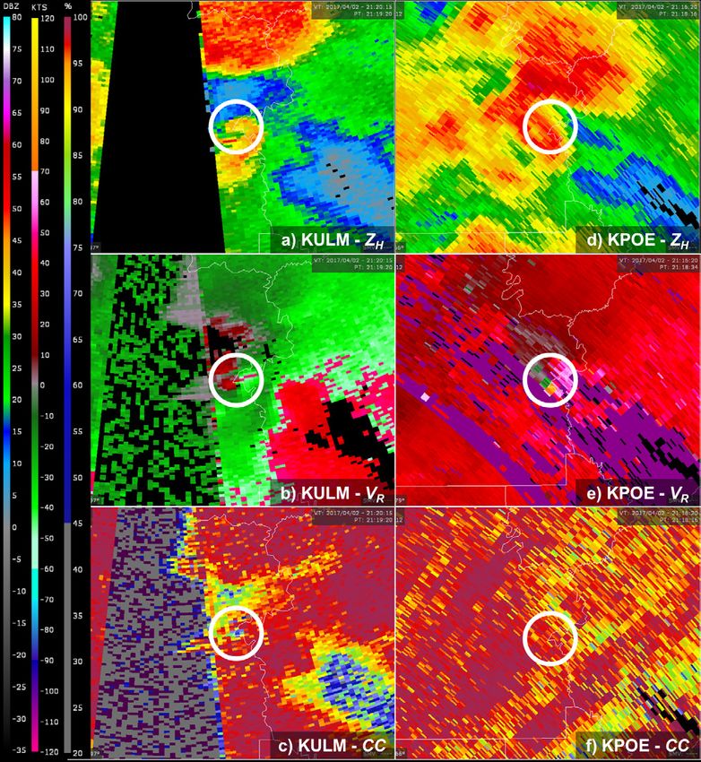
Murphy et al.                              NWA Journal of Operational Meteorology                             9 July 2019

(VORTEX-SE) field campaign (National Severe Storms
Laboratory 2018).

a. Specifications and operations

     The KULM radar was manufactured by EEC and
represents their DWSR-8501S SIDPOL radar system.
It is considered nearly equivalent to the WSR-88Ds
which comprise the NEXRAD network. A summary
of the major KULM specifications and its comparison
to the WSR-88D are given in Table 1. KULM is a
polarimetric S-band Doppler radar with an operating
frequency (wavelength) of 2.950 GHz (10.162 cm)
and peak transmit power of 850 kW. KULM operates
in a simultaneous transmit/receive mode. The pulse
repetition frequency (PRF) is user selectable from 200-
1180 Hz dependent upon the pulse duration selections of
0.5, 0.8, 1.0, or 2.0 μs. The gate spacing is ≤250 m, with
typical operations set at 125 m. The antenna system,
approximately 55 m MSL, is comprised of a parabolic,
prime focus reflector with a diameter of 8.5 m, antenna
gain of approximately 46 dB, and horizontal (vertical)
half-power beam width equal to 0.93° (0.91°). Perhaps
the biggest deviation from the WSR-88D is the choice in
transmitter – KULM uses a magnetron oscillator versus
the klystron amplifier used by the WSR-88D. Sireci                 Figure 2. The KULM radar located behind the
(2008) outlines the many advantages and disadvantages              ULM Visual and Performing Arts annex building,
of the different weather radar transmitter types. Perhaps          approximately 6 km due east of ULM’s main campus.
the biggest differences between the two are cost and
coherency. Magnetrons are cheaper, but lack the phase
stability of klystron transmitters.                                (PPI) scans. In that sense, KULM can be considered an
     KULM is located at 32.529392°, –92.012115°,                   operational research radar. For example, to facilitate
approximately 3 km northeast of the Monroe Regional                fast low-level updates, the most common scan strategy
Airport (MLU), and 6 km due east of the ULM                        during severe and hazardous weather consists of
campus. Figure 2 shows KULM shortly after it became                five elevation angles (0.7, 1.8, 3.1, 4.0, and 5.1°)
operational. KULM user control and data transmission               completing in ~90 s. However, scanning also attempts
are accomplished through a 10Gbps fiber line from the              to mimic NEXRAD VCPs if requested. For example,
radar site to ULM’s campus. Power backup is provided               scan strategies that are similar to VCPs 35 (clear air),
by a natural gas generator. The radar is operated by               215 (general precipitation), and 12/212 (fast evolving,
faculty and students at ULM in both classroom and                  convective) are available. There also are plans to test
research environments.                                             novel scan strategies with WFO SHV and JAN during
     To meet the objectives of the original GOHSEP                 various weather scenarios. The operational KULM
hazard mitigation grant, KULM operates continuously.               data are archived in the CfRadial compliant netcdf
Because it is not a NWS radar, scan strategies are not             format (Dixon et al. 2013) and include the following
bound by the conventional NEXRAD volume coverage                   radar moments: horizontal reflectivity factor (Zh),
patterns (VCP) (Radar Operations Center 2015; Federal              radial velocity (Vr), spectrum width (SW), differential
Handbook 2017) but are instead more adaptable and                  reflectivity (Zdr), correlation coefficient (CC), and
flexible for the given situation. KULM is able to                  differential propagation phase (Φdp). Raw data, which
perform both sector and range height indicator (RHI)               include the full suite of available radar moments, are
scans, in addition to the typical plan position indicator          archived when the radar is utilized during specific
                                                                   research projects.

ISSN 2325-6184, Vol. 7, No. 8                                107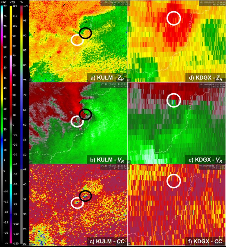
Murphy et al.                              NWA Journal of Operational Meteorology                            9 July 2019

Table 1. Major Specifications of KULM versus the WSR-88D
                                                           KULM                                   WSR-88D
 Transmitter Type                                        Magnetron                                 Klystron
 Frequency                                               2.950 GHz                              2.7 – 3.0 GHz
 (Wavelength)                                           (10.162 cm)                              (~10.71 cm)
 Peak Power                                                850 kW                                  700 kW
 Pulse Width                                       0.5, 0.8, 1.0, & 2.0 μs                     1.57 & 4.71 μs
 Antenna Diameter                                       8.5 m (28 ft)                            8.5 m (28 ft)
 Beamwidth                                                  0.93°                                     1°
 Gate Spacing                                             ≤ 250 m                                   250 m
 Sensitivity                                      –20 dBZ @ 30 km range                    –23 dBZ @ 25 km range
 Minimum Detectable Signal                               –114 dBm                                 –118 dBm
 Maximum Antenna Rotation Rate                              36 °/s                                  30 °/s

    To facilitate data sharing with the NWS, the
operational CfRadial data are converted to the NEXRAD
level-2, msg-31 format using a locally modified version
of the NCAR Radx C++ libraries (Heistermann et
al. 2015). NWS real-time access is provided via
an internal ULM polling site for the Gibson Ridge
(GR) Level 2 Analyst software (www.grlevelx.com/
gr2analyst_2/). These data are publicly available via the
Iowa Environmental Mesonet (IEM) NEXRAD level-2
polling site (www.mesonet-nexrad.agron.iastate.edu/
level2/raw/). Live images of Zh and Vr at the lowest
elevation are generated using the Python ARM Radar
Toolkit (Py-ART; Helmus and Collis 2016) and are
available via www.wxdata.geos.ulm.edu/ULMradar/.                  Figure 3. 100 km range rings from KSHV, KDGX,
                                                                  KPOE, and KULM (blue shaded circles) and a 50 km
b. Coverage improvements                                          range ring from KULM (red shaded circle). At 100 km,
                                                                  minimum center beam height for 0.5° elevation is ~1.8
    As previously mentioned, the WSR-88Ds nearest                 km AGL. At 50 km, minimum center beam height for
Monroe, Louisiana are >170 km away, leaving a gap in              0.5° elevation is ~0.8 km AGL.
NEXRAD coverage with some areas having a lowest
beam height >3.0 km AGL (Fig. 1). Figure 3 shows 100              c. Unresolved issues
km range rings from the nearest WSR-88Ds (KSHV,
KDGX, and KPOE), as well as KULM. It additionally                     Since beginning operations and providing data to
shows a 50 km range ring from KULM. Assuming                      the NWS, several unresolved issues have been noted
standard refraction and a 0.5° elevation angle, the               that have the potential to adversely affect data quality
minimum center beam height is 1.8 km AGL at 100                   and how the data are used by NWS meteorologists. The
km, and 0.8 km AGL at 50 km. KULM, being nearly                   KULM data are not currently available via the Advanced
equidistant from KSHV and KDGX, effectively removes               Weather Interactive Processing System (AWIPS). The
the low-level coverage gap across the ArkLaMiss. In               WarnGen program in AWIPS is used exclusively by the
locations within 50 km of KULM, where the minimum                 NWS for the generation of convective warning products.
beam height was previously ~2.0–3.0 km AGL, KULM                  This software provides a simple method for pinpointing
has improved the low-level coverage to ≤0.8 km AGL.               the location of severe weather and projecting storm
                                                                  motion based on radar data displayed within AWIPS.
                                                                  As mentioned above, NWS WFOs use the GRLevel2

ISSN 2325-6184, Vol. 7, No. 8                               108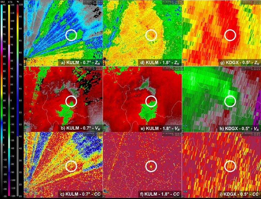
Murphy et al.                             NWA Journal of Operational Meteorology                             9 July 2019

Analyst software to view and analyze KULM data.
Because KULM data are not available in AWIPS, it is
more difficult for meteorologists to be as precise with
storm location and storm motion when using these data
to generate warnings.
    There also are issues with low-level data gaps. For
example, low-level tree blockage adversely affects data
up to ~1.5° elevation between approximate azimuths
323° and 70°. ULM is working with the landowners
to lower or totally remove the trees just north of the
radar site. KULM also is located ~1.6 km due north
of the airport surveillance radar (ASR) at the Monroe            Figure 4. Tornado tracks (white outlines) within 50
Regional Airport (MLU), and at its current antenna               and 100 km range (yellow circles) of KULM (yellow
height, directly interferes with the ASR through power           triangle) on 2 April 2017. The red line indicates
saturation. To remedy this interference, an intentional          the county warning area boundary between NWS
10° sector blank is inserted between azimuths 175° and           Shreveport and Jackson.
185° for all elevations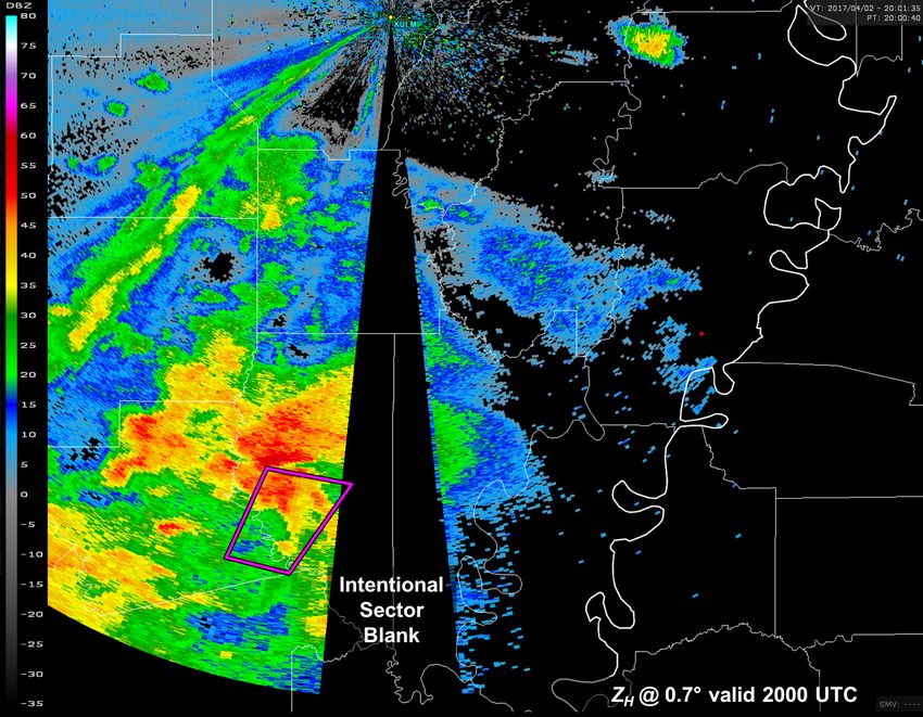
Murphy et al.                           NWA Journal of Operational Meteorology                               9 July 2019

                                                               Figure 7. KULM and KPOE comparison for the
                                                               Caldwell/Franklin/Richland EF-1 tornado near the time
                                                               of tornadogenesis. Shown for KULM are (a) horizontal
                                                               reflectivity factor (dBZ), (b) radial velocity (kts), and
                                                               (c) correlation coefficient at 0.7° elevation valid 2119
                                                               UTC 2 April 2017. Panels (d)-(f) are similar but from
                                                               KPOE at 0.4° elevation valid 2118 UTC. White circles
                                                               indicate the location of the initial TDS observed from
                                                               KULM. Velocity aliasing is present in (b)2. Click the
Figure 6. Horizontal reflectivity factor (dBZ) from            image for an animation of the KULM data valid 2114–
KULM valid 2112 UTC 2 April 2017 at (a) 0.7° and               2143 UTC in 1 min intervals.
(b) 3.1° elevation angles. The white circle indicates
the parent supercell of the Caldwell/Franklin/Richland              Following Thompson et al. (2017) and Cohen et al.
EF-1 tornado about five min prior to tornadogenesis.           (2018), simulated tornado probabilities and intensities
Tornado warning polygons are as in Fig. 5.                     were calculated from each radar dataset using the lowest
                                                               elevation angle over the tornado’s duration. Cohen et
after exiting the low-level sector blank, a tornadic           al. (2018) determined the best predictors for tornado
debris signature (TDS; Rhzhkov et al. 2005; Schultz et         potential are peak average rotational velocity (VROT;
al. 2012a,b; Van Den Broeke and Jauernic 2014) was             kts), circulation diameter (DIST; n mi), a subjective
apparent on KULM (Fig. 7a-c). Data from KPOE, the              clear or tight circulation designation (CT), and effective-
nearest NEXRAD, was ambiguous as to whether a TDS              layer significant tornado parameter (STP). Similarly,
was present (Fig. 7d-f). At its lowest elevation angle         the best predictors for simulated tornado intensity are
(0.7°), KULM sampled the TDS in Fig. 7a-c at ~0.8              height of circulation above radar level (ARL; ft), VROT,
km AGL; KPOE sampled the same area at ~2.5 km                  STP, and whether or not a TDS is present. KULM data
AGL at 0.4° (Fig. 7d-f). The KULM data allowed WFO
JAN to enhance the wording in their tornado warning to
“radar confirmed tornado” at 2123 UTC, which would             2
                                                                 KULM data were stripped of information regarding
not have been possible with the NEXRAD data alone.             its Nyquist velocity during data conversion, leading
                                                               to a failure of the automatic de-aliasing algorithm in
                                                               GRLevel2. This was corrected in summer 2017.

ISSN 2325-6184, Vol. 7, No. 8                            110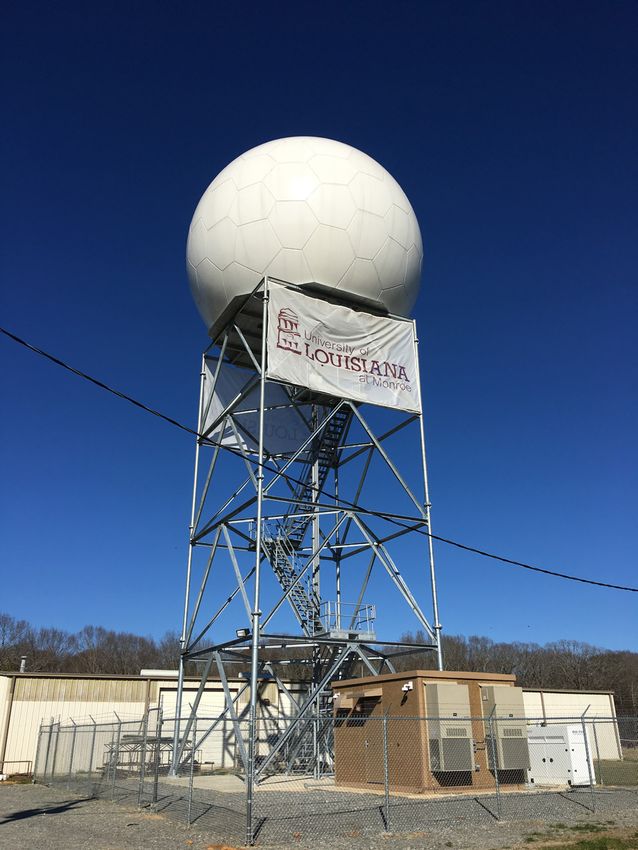
Murphy et al.                            NWA Journal of Operational Meteorology                               9 July 2019

with input predictors of ARL = 2310 ft, VROT = 44.2
kts, DIST = 0.2 n mi, CT = 1, TDS = 1, and STP ≈
4 yielded a simulated tornado probability of 69% and
simulated tornado wind speed of 106 mph. The actual
estimated peak wind speed based on the NWS survey
was 110 mph. KPOE data yielded a simulated tornado
probability of 37% and simulated tornado wind speed
of 101 mph (input predictors: ARL = 7000 ft, VROT =
51.3 kts, DIST = 1.5 n mi, CT = 0, TDS = 0, and STP ≈
4). Whereas the potential intensity compared favorably
between the radars and the actual tornado intensity,
KULM data indicated a much higher probability of
tornado occurrence, which should improve tornado
warning confidence.
     The South Richland EF-1 and Mangham EF-1
tornadoes developed at 2148 and 2149 UTC,
respectively. KULM data showed two concurrent TDSs
(Fig. 8a-c) for approximately two min, indicating the
parent supercell produced two tornadoes at the same
time. This was later confirmed by the NWS JAN storm
survey. KULM sampled these TDSs at ~0.5 km AGL.
The nearest NEXRAD, KDGX, did not indicate any                  Figure 8. As in Fig. 7 but for KULM at 0.7° elevation
TDS, as the lowest scan sampled was ~3.0 km AGL                 valid 2152 UTC 2 April 2017 and KDGX at elevation
(Fig. 8d-f). In addition, the midlevel rotation on KDGX         0.5° valid 2151 UTC 2 April 2017. In panels (a)-(c),
was displaced north of the actual low-level TDSs from           the white circle represents the TDS from the South
KULM (Fig. 8e) and the observed tornado damage path.            Richland EF-1 tornado and the black circle represents
The KULM data allowed WFO JAN to extend tornado                 the TDS from the Mangham EF-1 tornado. In panels
warnings with greater confidence than NEXRAD data               (d)-(f), the white circle represents the area of strongest
alone would have allowed (C. Entremont and J. Lamb,             rotation on KDGX, which is displaced north of the low-
NWS Jackson, 2017, personal communication). KULM                level KULM TDSs. Click the image for an animation
data indicated a simulated tornado probability of 74%           of the KULM data valid 2145–2201 UTC in 1 min
and wind speed of 108 mph (input predictors: ARL =              intervals.
1,570 ft, VROT = 48.1 kts, DIST = 0.15 n mi, CT =
1, TDS = 1, and STP ≈ 4), compared to 32% and 97                volume scans every 56 s. The region where the tornado
mph from KDGX (input predictors: ARL = 10 500 ft,               developed is within the low-level tree blockage north of
VROT = 40.8 kts, DIST = 1.0 n mi, CT = 0, TDS = 0,              KULM, obscuring many of the radar moments at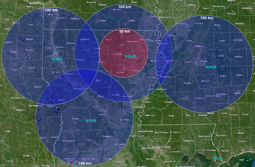
Murphy et al.                             NWA Journal of Operational Meteorology                             9 July 2019

                                                                 April 2018. The bulk of these tornadoes occurred on
                                                                 13-14 April in Arkansas, Louisiana, and Mississippi. In
                                                                 particular, northern Louisiana and southern Arkansas
                                                                 were impacted by two rounds of severe weather on
                                                                 13-14 April, including late afternoon/early evening
                                                                 tornadic supercell thunderstorms, and an overnight
                                                                 tornadic QLCS. A total of 23 tornadoes occurred in
                                                                 this region, 17 of those within 100 km range of KULM
                                                                 and 8 within 50 km range (Fig. 11) (National Centers
                                                                 for Environmental Information 2018). This event is
                                                                 unique in that operations associated with the VORTEX-
Figure 9. As in Fig. 4 but for 30 April 2017.                    SE field program occurred in northern Louisiana,
                                                                 leading to an exceptional set of observations for both
                                                                 the supercells and the QLCS. KULM was operating in
                                                                 a 5-tilt volume mode (0.7°, 1.8°, 3.1°, 4.0°, and 5.1°),
                                                                 providing new volume scans every 90 s. Compared
                                                                 herein are KULM and KSHV data associated with the
                                                                 “Calhoun” supercell, which produced the Calhoun EF-
                                                                 1, Downsville EF-1, and Sterlington EF-1 tornadoes.
                                                                      KULM and KSHV data near the genesis time of the
                                                                 Calhoun EF-1 (2334 UTC) tornado are shown in Fig. 12.
                                                                 The initial tornado warning from WFO SHV was issued
                                                                 at 2328 UTC based on “radar indicated rotation” from
                                                                 KULM. A clear hook echo in Zh and broad, cyclonic
                                                                 low-level circulation in Vr was observed from KULM
                                                                 (Fig. 12a, b). VROT increased from 25.2 kts to 45.7
                                                                 kts shortly after the tornado formed; a TDS on KULM
                                                                 was apparent by 2335 UTC. Near this same time, the
Figure 10. As in Fig. 7 but for KULM at 0.7° elevation           tornado was visually sighted by the NOAA P-3 research
(a)-(c) and 1.8° elevation (d)-(f) valid 0946 UTC 30             aircraft participating in the VORTEX-SE project (www.
April 2017. Panels (g)-(i) are KDGX at 0.5° elevation            mesonet.agron.iastate.edu/wx/afos/201804132340_
valid 0945 UTC 30 April 2017. The white circle                   LSRSHV.png), only the second time the P-3 has sighted
represents the area of rotation and TDS observed on              a tornado and likely the first time a tornado report from
KULM associated with the Oak Ridge EF-1 tornado.                 a research aircraft made it into NWS products (C.
The beam height within the circled area is ~0.25 km              Ziegler and E. Rasmussen, NOAA NSSL/OU CIMMS,
AGL in (a)-(c), ~0.6 km AGL in (d)-(f), and ~3.3 km              2018, personal communication). A second tornado, the
AGL in (g)-(i). Velocity aliasing is present in (b) and          Downsville EF-1, formed at 2343 UTC. Near the end of
(e).

surveyed (C. Entremont and J. Lamb, NWS Jackson,
2017, personal communication). Simulated tornado
probability and wind speeds were not calculated for this
case, given the uncertainty imparted by the low-level
tree blockage.

c. 13 April 2018

    A multi-day severe weather episode, with
approximately 70 confirmed tornadoes, impacted
portions of the southeastern United States on 13-15
                                                                 Figure 11. As in Fig. 4 but for 13-14 April 2018.

ISSN 2325-6184, Vol. 7, No. 8                              112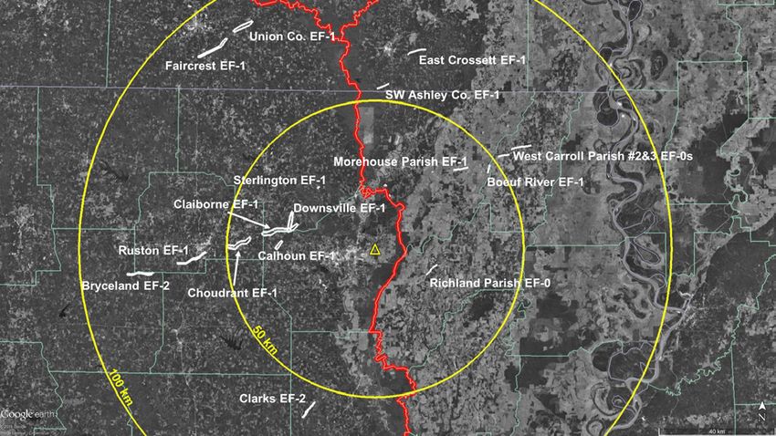
Murphy et al.                           NWA Journal of Operational Meteorology                           9 July 2019

                                                               VROT = 36.4 kts, DIST = 0.75 n mi, CT = 1, TDS =
                                                               0, and STP ≈ 2.8). STP was estimated from a 23 UTC
                                                               sounding launched by ULM in Monroe, Louisiana. The
                                                               actual estimated peak wind speed based on the NWS
                                                               survey for both tornadoes was 105 mph. KSHV data
                                                               alone were inconclusive regarding the tornado potential
                                                               of this supercell, and without KULM, WFO SHV would
                                                               have needed spotter reports to confirm the presence of
                                                               a tornado. KULM allowed WFO SHV to not only issue
                                                               more confident tornado warnings, but also refine those
                                                               warnings with better geographic precision (C. Palmer,
                                                               NWS Shreveport, 2018, personal communication).

                                                               4. Discussion and conclusion

                                                                    Data from non-NEXRAD, gap-filling radars,
                                                               such as KULM, provide valuable information during
                                                               the warning-decision process. KULM has become an
                                                               important tool for NWS WFOs SHV and JAN. It has
                                                               been incorporated into operations at these offices,
                                                               helping to improve the NWS mission of protecting life
Figure 12. As in Fig. 7 but for KULM at 0.7° elevation         and property. Its data proved invaluable during active
and KSHV at 0.5° elevation, both valid 2333 UTC 13             spring severe weather seasons in 2017 and 2018 across
April 2018. The white polygons represent the Calhoun           the ArkLaMiss. At least five additional tornadoes have
EF-1 and Downsville EF-1 tornado tracks. The beam              been warned and surveyed (to date) by WFO JAN that
height within the hook echo region of panels (a)-(c)           may not have been surveyed otherwise due to a lack
is ~0.4–0.5 km AGL. For the same region, the KSHV              of damage reports and inconclusive NEXRAD data.
beam height is ~2.5 km AGL. Click the image for an             During each of these events TDSs were observed by
animation of the KULM data valid 2330–2355 UTC in              KULM. This does not imply that NWS warning services
90-s intervals.                                                are degraded without KULM, but instead, improved
                                                               radar data lead to improved detection of severe and
                                                               hazardous weather. A climatology of tornadogenesis
this tornado, mesocyclone occlusion is clearly evident
                                                               points within 100-km of KULM (1950-2014) indicates
on KULM as the hook echo seemingly pulls back into
                                                               the region averages approximately eight tornadoes per
the larger precipitation echo (Fig. 12 animation).
                                                               year. This number is expected to increase, consistent
     KULM sampled the low-level circulations
                                                               with the tornado reporting trends after implementation
associated with these two tornadoes at approximately
                                                               of the WSR-88D network in the early 1990s (McCarthy
0.4–0.5 km AGL. The nearest NEXRAD, KSHV,
                                                               and Schaefer 2004; Coleman and Dixon 2014).
viewed the storm at approximately 2.5 km AGL (Fig.
                                                                    During severe weather operations at WFO SHV
12d-f). From KSHV, modest midlevel rotation (VROT
                                                               and JAN, forecasters now rely on KULM when there is
= 26.2 kts) associated with the mesocyclone was
                                                               convection over northeastern Louisiana and portions of
observed; KSHV VROT increased to a maximum of
                                                               southeastern Arkansas in the same manner they would
36.4 kts. KSHV also observed a low-reflectivity region
                                                               rely on other radar sites in the NEXRAD network
associated with the updraft and bounded weak echo
                                                               (C. Entremont, J. Lamb, and C. Palmer, NWS, 2018,
region. The midlevel rotation was displaced north of
                                                               personal communication). At WFO JAN, a separate
the low-level circulation and TDS observed via KULM.
                                                               forecaster has been tasked with monitoring KULM
KULM data indicated a simulated tornado probability
                                                               and relaying pertinent information to the forecaster
of 73% and wind speed of 106 mph (input predictors:
                                                               issuing warnings during some past more impactful and
ARL = 1,395 ft, VROT = 47.6 kts, DIST = 0.15 n mi,
                                                               widespread severe weather events (C. Entremont and J.
CT = 1, TDS = 1, and STP ≈ 2.8), compared to 49% and
                                                               Lamb, NWS Jackson, 2018, personal communication).
91 mph from KSHV (input predictors: ARL = 7,800 ft,

ISSN 2325-6184, Vol. 7, No. 8                            113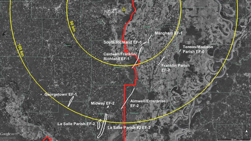
Murphy et al.                               NWA Journal of Operational Meteorology                               9 July 2019

All workstations used by warning forecasters are                    public and private entities acquiring systems of various
equipped with GRLevel2 Analyst software, which                      frequencies. These systems present a unique opportunity
forecasters use to monitor KULM data on a real-time                 for data sharing agreements with the NWS that could
basis as they make warning decisions. Because of the                be modeled after KULM for gap-filling radars. NWS
closer proximity of KULM, more accurate location                    WFOs should reach out to those radar owners about the
information can be added to the NWS warnings in terms               possibility of incorporating their data into operations;
of current position of the tornado, along with improved             such data have the potential to enhance warning
timing for pathcasts (arrival time to towns/cities).                operations and information shared with partners. If such
This information is extremely valuable to the warning               partnerships are possible, WFOs should work closely
forecaster as well as in communicating more specific                with the radar owners to understand the capabilities
location information directly to county officials.                  and limitations of the radar. The NWS should provide
     In most severe weather situations, a scanning                  radar partners technical support to arrange for data
strategy limited to lower elevation scans has been                  delivery if necessary and also support incorporating
utilized for KULM. Forecasters have found this to be                non-NEXRAD data into AWIPS.
the most beneficial, as it provides more frequent updates
and improves radar coverage for the northeast Louisiana                 Acknowledgments: This paper was funded by
region. Data that would be obtained by scanning at                  the ULM Endowed Professorship in Geosciences.
higher elevations are largely already being collected by            Data collection and analysis of the 13 April 2018
surrounding radar sites, and thus holds lesser value to             case occurred during the VORTEX-SE field project
NWS meteorologists during active weather events.                    supported by the United States Weather Research
     An open line of communication between ULM,                     Program within NOAA/OAR/OWAQ under contract
WFO SHV, and JAN has allowed for improvements in                    RA133R18SE0299. We thank the Louisiana GOHSEP
radar operations and data delivery to better support the            for providing funds to support the construction of the
NWS mission. For example, ULM maintains flexibility                 ULM radar. Drs. Eric Pani and Anne Case Hanks are
in scanning strategy to deliver the best possible                   acknowledged for the pivotal role they played in securing
information to the WFOs. The WFOs alert ULM                         the original grant to support the radar’s construction.
personnel if they notice data problems, such as Zh or               Meteorologists at NWS WFO Shreveport and Jackson,
Zdr calibration issues. However, a non-NEXRAD radar                 and local emergency managers, are acknowledged
still presents challenges. Data delivery, for example,              for their feedback on improving radar operations in
is dependent on the reliability of the ULM network.                 support of their missions. Drs. Conrad Ziegler and
KULM volume scans are not available on a “tilt-by-                  Erik Rasmussen are acknowledged for information
tilt” basis, only when a volume completes and after                 regarding P-3 tornado sightings. Finally, we would like
converting to the 88D compatible format. This can                   to acknowledge the three anonymous reviewers for
cause a slight time delay in the delivery of volumes.               providing comments that greatly improved the original
Unavailability in AWIPS also is an inconvenience, as                manuscript.
previously noted, though the data are extremely useful
even without the ability for AWIPS interrogation.                                      _____________________
Work is underway to minimize the time delay, and
perhaps have the data available via AWIPS. Another
important takeaway is that where a radar is built plays                                    REFERENCES
a substantial role in terms of data quality. ULM did not
have the luxury to select a pristine radar site, but others         Beck, J. and O. Bousquet, 2013: Using gap-filling radars
exploring gap-filling radars should properly survey                    in mountainous regions to complement a national radar
                                                                       network: Improvements in multiple-Doppler wind
potential sites to minimize blockage or other issues that
                                                                       syntheses. J. Appl. Meteor. Climatol., 52, 1836–1850,
adversely impact data quality. Although there is room
                                                                       CrossRef.
for additional improvements, the radar is achieving its             Campbell, L. S. and W. J. Steenburgh, 2014: Finescale
ultimate goal of improving hazard mitigation across the                orographic precipitation variability and gap-filling
region.                                                                radar potential in Little Cottonwood Canyon, Utah. Wea.
     As the cost of Doppler weather radar systems                      Forecasting, 29, 912–935, CrossRef.
decrease, there has been an increase in the number of

ISSN 2325-6184, Vol. 7, No. 8                                 114
Murphy et al. NWA Journal of Operational Meteorology 9 July 2019
Chandrasekar, V., Y. Wang, M. Maki, and K. Nakane, 2009: Maddox, R. A., J. Zhang, J. J. Gourley, and K. W. Howard,
Urban flood monitoring using X-band dual-polarization 2002: Weather radar coverage over the contiguous
radar network: Program of the CASA-NIED partnership. United States. Wea. Forecasting, 17, 927–934, CrossRef.
Preprints, 34th Conf. on Radar Meteorology, McCarthy, D. W., and J. T. Schaefer, 2004: Tornado trends
Williamsburg, VA, Amer. Meteor. Soc., P10A.1. over the past thirty years. Preprints, 14th Conf. on
[Available online at ams.confex.com/ams/34Radar/ Applied Climatology, Seattle, WA. Amer. Meteor. Soc.,
techprogram/paper_156019.htm.] 3.4. [Available online at ams.confex.com/ams/84Annual/
Chrisman, J. N., 2009: Automated Volume Scan Evaluation techprogram/paper_72089.htm.]
and Termination (AVSET): A simple technique to achieve McLaughlin, D., and Coauthors, 2009: Short-wavelength
faster volume scan updates. Preprints, 34th Conf. on technology and the potential for distributed networks
Radar Meteorology, Williamsburg, VA, Amer. Meteor. of small radar systems. Bull. Amer. Meteor. Soc., 90,
Soc., P4.4. [Available online at ams.confex.com/ams/ 1797–1817, CrossRef.
pdfpapers/155324.pdf.] National Centers for Environmental Information, 2018:
Cohen, A. E., J. B. Cohen, R. L. Thompson, and B. T. Smith, Storm events database. [Available online at www.ncdc.
2018: Simulating tornado probability and tornado wind noaa.gov/stormevents/].
speed based on statistical models. Wea. Forecasting, 33, National Severe Storms Laboratory, 2018: VORTEX
1099–1108, CrossRef. Southeast. [Available online at www.nssl.noaa.gov/
Coleman, T. A., and P. G. Dixon, 2014: An objective analysis projects/vortexse/].
of tornado risk in the United States. Wea. Forecasting, Radar Operations Center, 2015: WSR-88D Volume Coverage
29, 366–376, CrossRef. Pattern (VCP) Improvement Initiatives. [Available
Crum, T., S. D. Smith, J. N. Chrisman, R. E. Saffle, R. W. online at www.roc.noaa.gov/WSR88D/PublicDocs/
Hall, and R. J. Vogt, 2013: WSR-88D radar projects— NewTechnology/New_VCP_Paradigm_Public_
Update 2013. Proc. 29th Conf. on Environmental Oct_2015.pdf
Information Processing Technologies, Austin, TX, Radar Operations Center, 2017: NEXRAD and TDWR Radar
Amer. Meteor. Soc., 6B.1. [Available online at ams. Locations. Accessed 25 May 2018, www.roc.noaa.gov/
confex.com/ams/93Annual/webprogram/Paper221461. WSR88D/maps.aspx.
html.] Ryzhkov, A. V., T. J. Schuur, D. W. Burgess, and D. S. Zrnić,
Dixon, M., W.-C. Lee, B. Rilling, and C. Burghart, 2013: 2005: Polarimetric tornado detection. J. Appl. Meteor.,
CfRadial data file format: Proposed CF-compliant 44, 557–570, CrossRef.
netCDF format for moments data for RADAR and Sireci, O., 2008: Comparison of transmitters of weather radars:
LIDAR in radial coordinates. NCAR, 66 pp. [Available Preprints, WMO Technical Conference on Meteorological
online at www.eol.ucar.edu/system/files/CfRadialDoc. and Environmental Instruments and Methods of
v1.3.20130701.pdf.] Observation, St. Petersburg, Russia, World
Federal Handbook, 2017: Federal Meteorological Handbook Meteorological Organization, P1.29. [Available online
No. 11, WSR-88D Meteorological Observations, Part at www.wmo.int/pages/prog/www/IMOP/publications/
C: WSR-88D Products and Algorithms, 394 pp. IOM-96_TECO-2008/P1(29)_Sireci_Turkey.doc.]
[Available online at www.ofcm.gov/publications/fmh/ Schultz, C. J., and Coauthors, 2012a: Dual-polarization
FMH11/fmh11partC.pdf]. tornadic debris signatures part I: Examples and utility in
Gibbs, J. G., 2016: A skill assessment of techniques for real an operational setting. Electronic J. Oper. Meteor., 13,
time diagnosis and short-term prediction of tornado 120–137
intensity using the WSR-88D. J. Operational Meteor., Schultz, C. J., and Coauthors, 2012b: Dual-polarization
4(13), 170-181, CrossRef. tornadic debris signatures part II: Comparisons and
Gourley, J. J., D. P. Jorgensen, S. Y. Matrosov, and Z. L. caveats. Electronic J. Oper. Meteor., 13, 138–150.
Flamig, 2009: Evaluation of incremental improvements Thompson, R. L., and Coauthors, 2017: Tornado damage
to quantitative precipitation estimates in complex terrain. rating probabilities derived from WSR-88D data. Wea.
J. Hydrometeor., 10, 1507–1520, CrossRef. Forecasting, 32, 1509–1528, CrossRef.
Heistermann, M., and co-authors, 2015: The emergence of Torres, S., and C. Curtis, 2007: Initial implementation of
open-source software for the weather radar community. super-resolution data on the NEXRAD network.
Bull. Amer. Meteor. Soc., 96, 117–128, CrossRef. Preprints, 23rd Int. Conf. on Interactive Information and
Helmus, J. J., and S. M. Collis, 2016: The Python ARM Radar Processing Systems (IIPS) for Meteorology,
Toolkit (Py-ART), a library for working with weather Oceanography, and Hydrology, San Antonio, TX, Amer.
radar data in the python programming language. J. Open Meteor. Soc., 5B.10. [Available online at ams.confex.
Research Software, 4(1), 25 pp., CrossRef. com/ams/pdfpapers/116240.pdf].
ISSN 2325-6184, Vol. 7, No. 8 115Murphy et al. NWA Journal of Operational Meteorology 9 July 2019
Van Den Broeke, M. S., and S. T. Jauernic, 2014: Spatial
and temporal characteristics of polarimetric tornadic
debris signatures. J. Appl. Meteor. Climatol., 53, 2217–
2231, CrossRef.
ISSN 2325-6184, Vol. 7, No. 8 116You can also read