CITY OF LAKE VIEW URBAN ISSUES PLAN
←
→
Page content transcription
If your browser does not render page correctly, please read the page content below
Appendix A
CITY OF LAKE VIEW URBAN ISSUES PLAN
Black Hawk Lake: Urban Issues
The City of Lake View went through an extensive process to update the City’s Comprehensive
Plan in 2009 – 10. This plan identified priority issues to drive the development of Lake View into the
future. The top priority identified in the Comp Plan is the protection of Black Hawk Lake. Specifically,
the Number One priority to be implemented was to “Promote the use of “green solutions” to protect
water quality of Black Hawk Lake.”
The City of Lake View proposes several projects to protect Black Hawk Lake that fall under the
classification of public education or construction projects.
Years 1 through 5
In the Years One through Five, the City proposes to:
Develop our Lake Protection Association.
Obtain 100% utilization of phosphorous‐free fertilizers on yards.
Undertake a process to provide detailed maps of storm sewers and drainage
tiles flowing into Black Hawk Lake.
Install a rain garden on the City Hall property.
Place markers on intakes reminding folks not to dump into the intake as the
water runs to the lake.
Undertake an awareness campaign encouraging residents to keep their gutters
clean so that no debris & leaves flow to lake.
Install shoreline armoring on areas adjacent to Crescent Beach.
Install engineering solutions for storm sewers outletting into the lake.
Promote the installation of residential rain gardens.
Promote the use of rain barrels and provide rain barrels for volunteer
participants.
Implement an “Environmental Protection Zone” covering areas near water
bodies.
Lake Protection Association: Within the past few months, Black Hawk Lake has been developing a
fledgling Lake Protection Association (LPA). This group will be the “voice of Black Hawk Lake,”
advocating on behalf of the lake, educating the public about the lake project, and encouraging
environmentally‐friendly activities around the lake. The LPA was loosely organized under the direction
of Emily Busch, Lake View’s marketing consultant. The LPA seeks funding to keep Emily on board as a
contracted part‐time staff to work with the LPA, government agencies, and our watershed coordinator
to further the lake restoration project and keep the public well informed of the project.
Requested funds: Contract position at $1,000 per month for two years = $24,000.
Local Match: $12,000 paid to marketing consultant for 2011.
A‐1
“100% Phosphorous‐Free:” The City of Lake View proposes to partner with the Black Hawk Lake
Protection Association to encourage the voluntary use of phosphorous‐free fertilizers. This public
education will be done through the press and through mailings. Also, a $5.00 voucher will be provided
to each residence to be used toward the purchase of phosphorous‐free fertilizer at local retailers.

        Requested funds:      Semi‐annual print ads in the Lake View Resort for five years: $2,000.
                              Annual brochure mailing to all Lake View residences for five years: $2,000.
                              $5.00 voucher for the purchase of phosphorous‐free fertilizer. Two
                              vouchers per residence for one year. It is estimated that 500 residences
                              will participate = $5,000.
        Private match: Remainder of the cost of the fertilizer is $30.00 per residence. Total
                              private match = $15,000

Storm Sewer & Drain Tile Mapping: The City of Lake View does not have adequate maps of the public
storm sewer system or the public or private drain tiles in the area. The City proposes to use the services
of a consultant to assist City staff in researching records to determine sewer and tile locations and to
conduct field work to map the storm sewer and drainage tile system. This field work includes running
cameras through the tiles to determine tile location and condition.

        Requested funds:       Consulting firm: $10,000.
        Local match: 25% soft match for staff time.

City Hall Rain Garden: The City proposed to install a Rain Garden on the City Hall property. This would
be a pilot project to explain how a rain garden works and to show construction techniques. The City had
planned to install the Rain Garden as part of their 2009 Streetscape Project, but this project was not
completed due to funding constraints.

        Requested funds:       Construct Rain Garden: $5,000 (Engineers estimate from Snyder & Assoc.)
        Local match: 20% soft match for staff time & equipment usage.

Intake Marking: The City proposes to educate the public about the hazardous situations that can arise
when materials are dumped down storm sewer intakes. A permanent metal plaque will be attached to
each intake which drains to Black Hawk Lake stating something like “No Dumping – Drains to Lake.”

        Requested funds:       $ 1,000
        Local match: 25% soft match for staff time.

Awareness to Keep the Gutters Clean: Using newspaper articles, pieces in the City newsletter, and
through the City web site and the use of social media, homeowners will be reminded of the need to
keep the street gutters clean so that no debris & leaves flow to lake.

        Requested funds = 0; In‐kind City staff labor.

                                                     A‐2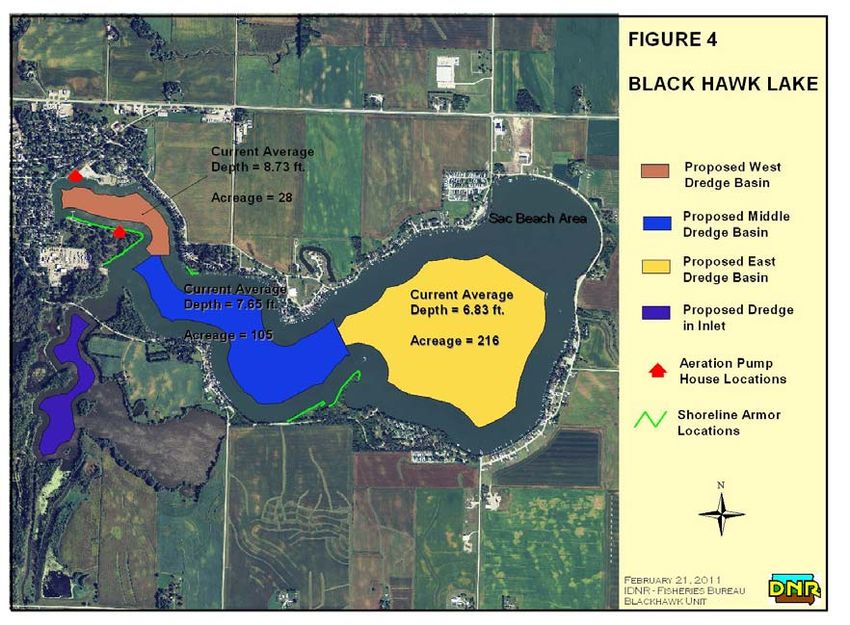
Shoreline Armoring: The City owns and operates Crescent Beach, a public swimming beach in the Town
Bay portion of Black Hawk Lake. Over the years, the sandy beach has eroded and the shoreline adjacent
to the beach on both sides has also eroded. The erosion of the lands adjacent to the beach can be
mitigated with the installation of more native stone shoreline armoring. The City proposes to add more
armoring for 100’ on the east side of the beach and 100’ on the west side of the beach.

        Requested funds: 200’ of shoreline armoring @ $55 / ft. = $ 11,000

Storm Sewer Outlets: There are successful examples of engineering solutions to storm water problems.
Upon examination of the known outlets of public storm sewers into the lake, there are at least two sites
where it would be feasible to install an engineered solution, such as a bio‐reactor, at the outlet of the
storm sewer. This bio‐reactor or other screening device catches many impurities before they arrive in
the lake.

Much more research is needed on the various types of engineering solutions to storm water
management problems.

Estimated Cost: Engineering solutions for two storm sewer outlets: $75,000 each = $150,000.

        Requested funds: $ 120,000
        Local match: $ 30,000

Residential rain gardens: The City will encourage the installation of small rain gardens on residential
properties, particularly on lakeshore lots. The City seeks funding to provide a 50% cost share to install
one residential rain garden per year. It is estimated that the 50% cost share will be $1,000 per project

        Requested funds: 50% cost share: $1,000 X 5 projects = $5,000
        Private match: 50%

Residential Rain Barrels: The City will encourage the use of residential rain barrels to collect and harvest
rain water for use in their yards and gardens. Harvesting rain water not only reduces the amount of
municipal water pumped from the ground, it also reduces the amount of run‐off that will eventually end
up in Black Hawk Lake. The cost of a rain barrel and stand is estimated at $75.00. The City proposes to
provide a rebate of $50.00 for any residence installing a rain barrel.

        Requested funds: Cost of $50.00 rebates for 100 rain barrels: $5,000
        Private match: Remainder of the cost of the rain barrel & stand for 100 barrels: $2,500

“Environmental Protection Zone.” The City’s recently completed Comp Plan recommends the
implementation of an Environmental Protection Zone for all areas within ¼ mile from a water body.
Goals and regulations for this Zone have not yet been established, but the concept behind this Zone will
be to encourage environmentally‐friendly actions to benefit the lake, and also to institute regulations
prohibiting certain actions which have negative environmental impacts. The City will need professional
assistance from engineers or planners to formulate and implement regulations putting into place this
proposed Environmental Protection Zone. The cost of the consultant firm is estimated to be $12,000.

        Requested funds: $10,000.
        Cash match from City: $2,000
        Soft match: $3,000 for staff time.
                                                    A‐3
New Developments
The Comp Plan also states that: Any urban development around the lake will require green solutions or
low impact development (LID) methodologies. The green solutions or LID refer to urban development
methodologies that will result in the least impact on the lake and the environment. Examples of these
LID methodologies may include:
Addressing drainage and water impoundment.
Encouraging use of pervious pavement / pavers.
Drainage and Water Impoundment: The City will establish standards for the storm water management
within the conservation zone around the lake for new site developments. Water will be detained on site
with the goal of slowing flow to the lake, allowing detention time for the water, and time for sediment
to settle out. We will utilize bioswales, or retention berms. An example currently under construction is
a retention basis west of the Glacier Bay restaurant. A retention basin was required to slow the flow of
water to the lake and provide for detention time prior to flowing into the storm sewer and thus into the
lake.
Run‐off from parking lots is of particular concern. During the Site Plan evaluation process,
developers need to show that they are slowing run‐off from the parking lot. This can be done by
channeling the drainage from the lot to a retention area.
It is anticipated that there will be at least three new commercial development projects within
the next five years. The City seeks funding to assist the developers with storm water management /
detention by participating in a cost‐share for required stormwater detention facilities. The proposed
cost share is 50% and the estimated cost of a retention structure is $4,000.
Requested funds: 50% cost share: $2,000 X 3 projects = $6,000
Private match: 50%
Pervious Pavement: Using pervious pavement or pavers has been proven effective in reducing the run‐
off from parking lots and other hard surfaces. The City will encourage the use of pervious pavement for
new development. It is estimated that pervious pavement costs two to three times as much as
conventional asphalt. The City seeks funding to provide a 50% cost share to install parking lots and
sidewalks using pervious pavement.
Requested funds: $30,000 – Estimate.
Private match: 50%
Future ‐ Years 6 through 10
The City will identify areas where BMP’s can be implemented or structures could be built. The City
proposes funding for the installation of:
Impoundment structures: There are many acres of tilled farmland within one‐quarter mile of Black
Hawk Lake. There are at least two sites within this farmland that may be suitable for the development
of permanent ponds.
Also, within the City’s General Land Use Plan there are at least three 10 to 20 acre sites which
are identified for future residential development. These sites will be developed utilizing low impact
development (LID) methodologies, including the installation of waterways and ponds.
The City seeks funding to assist with the installation of three ponds in the lands around Black
Hawk Lake.
Requested funds: Three ponds @ $30,000 each = $90,000.
A‐4
Residential rain gardens: The City will encourage the installation of small rain gardens on residential
properties, particularly on lakeshore lots. The City seeks funding to provide a 50% cost share to install
up to 25 more residential rain gardens. It is estimated that the 50% cost share will be $1,000 per project

        Cost of 50% cost share: $1,000 X 25 projects = $25,000
        Private match: 50%

TOTAL COST FOR THIS URBAN WATER QUALITY PLAN:
Years 1 ‐ 5                                                       Requested Grant Funds      Local Match
Lake Protection Association: Contract position for $1,000
per month for two years.                                                 $24,000                  $ 12,000
“100% Phosphorous‐Free” Campaign                                           $9,000                 $ 15,000
Storm Sewer & Drain Tile Mapping                                         $10,000             Soft ‐ $ 2,500
City Hall Rain Garden                                                     $5,000             Soft ‐ $1,000
Intake Marking                                                            $1,000             Soft ‐ $ 250
Awareness to Keep the Gutters Clean.                                       $0
Shoreline Armoring: 200’ of shoreline armoring @ $55 / ft                $ 11,000                 0
Storm Sewer Outlet – engineered solutions                                $ 120,000                $30,000
Residential rain gardens                                                 $ 5,000                  $ 5,000
Residential Rain Barrels: 100 incentives at $50 each for rain barrels    $5,000                   $ 2,500
“Environmental Protection Zone”                                          $10,000                  $ 2,000
                                                                                            Soft ‐ $3,000
New Developments: Drainage and Water Impoundment
50% cost share: $2,000 X 3 projects                                      $6,000                   $ 6,000
New Developments: Pervious Pavement. 50% cost share                      $30,000                  $ 30,000
                       Total Cost of Years 1 – 5                         $ 236,000                $ 109,250

Future Years 6 ‐ 10
Impoundment structures                                                   $ 90,000                 0
Residential rain gardens                                                 $ 25,000                 $ 25,000
                         Total Cost of Future Work: Years 5 – 10         $ 115,000                $ 25,000

        TOTAL COSTS                                                      $ 351,000                $ 134,250

*** Hard costs to the City are:
       Marketing Contract                        $ 8,000 to City and $4,000 to Community Club
       Storm Sewer outlets                       $ 30,000
       “Environmental Protection Zone”           $ 2,000

                                                     A‐5
APPENDIX B
IDNR Fisheries In‐Lake Management and Restoration Plan
Introduction
Black Hawk Lake supports a long tradition of sport fishing, waterfowl hunting, swimming, and
recreational boating. Marginal sport fishing still exists, waterfowl hunting can be good at times, and
large numbers of recreational boaters still use the lake. However, the degrading water quality continues
to impact these uses. Black Hawk Lake is the focal point of the city of Lake View, which is supported by
tourism that is created by the lake. Strong local support for restoring the lake, coupled with a multi‐
agency task force, shows a promising future for Black Hawk Lake.
Black Hawk Lake is listed as an impaired waterbody due to algae, turbidity, and bacteria as required by
section 303(d) of the Clean Water Act. After a statewide ranking of significant publicly owned lakes in
need of restoration, Black Hawk Lake was ranked in the top 35. In order to improve water quality
around the state, a recent push for lake restoration activities has included Black Hawk Lake. Two major
studies that investigated the issues affecting Black Hawk Lake and possible solutions were completed
within the last year. The information gathered in these studies provided working documents that can be
used to identify key solutions for removing Black Hawk Lake from the impaired waters list.
The Diagnostic Feasibility (DF) study conducted by Iowa State University and the Total Maximum Daily
Load (TMDL) study conducted by the Iowa DNR Watershed Improvement Section discussed a number of
management alternatives for in‐lake work to supplement and enhance the improvements to water
quality achieved through work done in the watershed. The logical progression of improvements to the
overall watershed and lake ecosystem would begin upstream in the watershed progressing downstream
and ultimately to the lake. Therefore, it would be appropriate to discuss in‐lake management
alternatives in the same manner.
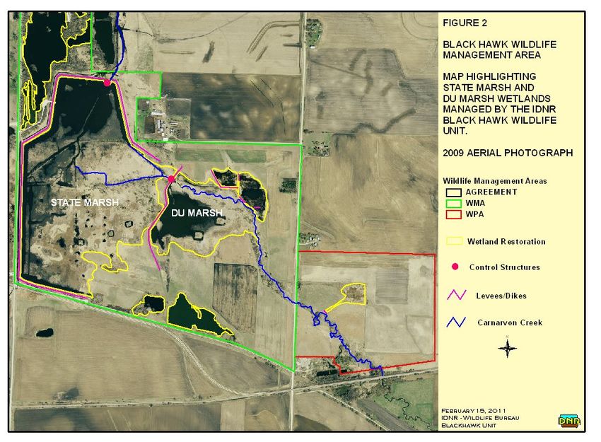
Black Hawk Lake can be broken into two components, the inlet (Figure 3) and the main basin (Figure 4).
The inlet area receives water from Carnarvon Creek, which then flows into the main basin. Although
both are considered to be part of Black Hawk Lake, and should be managed as such, the two basins are
currently separated by a fish barrier located on South State Road near the entrance to the Ice House
Point portion of Black Hawk State Park (Figure 5).
It should be noted that the various management alternatives presented are merely options for
improving the lake. Many of the options discussed in this document require further investigation to
assess the feasibility and costs associated with such practices. In some instances, a suite of scenarios
are presented for certain management alternatives so that different levels of costs and benefits can be
considered. Additionally, many of these practices should not be considered until notable improvements
in the watershed have been made. For instance, it would be premature to conduct dredging before
careful steps have been taken to reduce the input of sediment from the watershed. After a description
of the management options and associated benefits are presented, a timeline for management activities
is discussed as a three phase approach.
B‐1Narrative of Management Strategies
Inlet Area
The inlet portion of the lake is the first part of Black Hawk Lake to receive the main flow of water from
the watershed. As a result, it degrades at a faster rate than the main lake basin as it is the first to
intercept the bulk of the nutrients and sediments. Before significant anthropogenic disturbances in the
watershed severely reduced the functionality of the inlet area, it naturally served as a sediment
detention basin for Black Hawk Lake. The DF study and the TMDL study have identified the inlet portion
of the lake as a key component in restoring the entire lake ecosystem to its natural function.
Aquatic Vegetation Management
Emergent vegetation and other aquatic macrophytes are an essential part of a natural, healthy aquatic
ecosystem. Aquatic plant life competes with algae by taking up nutrients, provides habitat for fish and
wildlife, reduces wave energy from wind action, and helps keep bottom sediments in place through
complex root systems. Many aquatic plants, such as cattail and bulrush, rely on periods of drought for
seeds and turions to germinate. After drought periods, plants become inundated and eventually die off
and another drought is required to carry on the cycle. Due to the improved drainage of Iowa’s
agriculture fields through tile systems and the sheer size of the watershed to Black Hawk Lake, the inlet
area rarely dries up long enough to allow plants to reestablish. Pumping water out of the inlet and
moving it to the main lake basin is a means to replicate drought conditions, even in years with average
precipitation. The effects of pumping the inlet dry can be two‐fold. Mud flat conditions will allow
aquatic plants to reestablish and will also eliminate rough fish inhabiting the inlet area. The common
carp are instinctively drawn to shallow water areas during the spring to spawn. The inlet area serves as
prime spawning habitat for carp, and although there is currently a fish barrier in place, it is undersized
and fish can move into the inlet during high flows. As carp take advantage of the prime spawning
habitat provided by the inlet area, their offspring flourish in the absence of predator species. Young of
the year carp spawned in the inlet can then migrate through the fish barrier (due to their small size) and
enter the main lake basin. Periodically and temporarily draining the inlet will eliminate resident carp
allowing reestablished vegetation to remain unperturbed by rough fish. The volume of the inlet is
currently 257 acre feet, which equates to 83,743,707 gallons of water. With no influx of water to the
inlet, a 5,000 gallon per minute pump would dewater the inlet in about 11.5 days (279 hours).
Additionally, the elimination of carp from the inlet area will reduce the overall reproductive potential of
the carp population in the entire lake system. The proposed location for a pump station is at the inlet
bridge, which is easily accessible and electricity is readily available, next to the existing fish barrier
(Figure 3). Stop log structures would need to be installed so that water from the main lake basin does
not back flow into the inlet area during pumping. A platform on which to install the pump would need
to be constructed on the inlet because there is no room on or next to the roadway (Figure 5).
Hydraulic Dredging
Dredging in targeted areas could create settling basins and intercept sediment before it reaches the
main basin of the lake. In addition, vegetated shallow areas could slow down water forcing sediment to
B‐2drop out while simultaneously taking up nutrients and competing with algae. For the purposes of
discussing management in the inlet area, the water body can be divided into three zones (Figure 3).
Dredging in zone one would deepen the area that intercepts water from Carnarvon Creek and would act
as a primary settling basin. Dredging zone two would act as a secondary settling basin and provide a
path for water to flow to the pump during draw down. Zone one and two would be connected via a
narrow channel created by dredging. The purpose of the channel is to provide connectivity from the
deep water area of zone one to zone two so that the inlet can effectively be dewatered. A byproduct of
the deepening in these areas is better boat access and navigation for duck hunters from the boat ramp
out to some of the most popular duck hunting locations (which would remain intact) in the inlet. The
TMDL stated that longer residence time of water in the inlet would help to settle out sediments and
improve water quality in the main lake basin.
Many alternatives to increase residence time were discussed, including the construction of underwater
berms to direct flow between the island and Merehoff’s point, out into the east portion (zone three),
and back to the grade. While this would undoubtedly increase residence time of water, this would
create underwater obstructions to boat traffic, albeit there is little boat traffic in the inlet. Moreover, it
would make dewatering the inlet difficult by creating blockages of direct flow to the pump during draw
downs. Rather than constructing underwater berms and other structures to alter flow patterns, the
establishment of a diverse community of aquatic vegetation would slow down water and increase
residence time. Additionally, increasing the volume of the inlet would increase the residence time.
Because the majority of the flow moves through the grade at the inlet bridge, dredging zone three
would do little to intercept sediment from Carnarvon Creek. Although improving water quality is the
primary goal of this project, fish and wildlife habitat diversity are important factors to consider. The
aforementioned management plan for the inlet area would provide such diversity. Zone one and zone
two would provide deep water habitat, surrounded by emergent vegetation, with submergent
vegetation for diving ducks. Zone three would be left as is providing shallow wetland habitat for puddle
ducks, rails, muskrats, and other marshland animals. The primary recreational use of the inlet is duck
hunting and the proposed management activities would work to enhance it. Duck hunters would
benefit from the increased depth so that boats can easily access more of the inlet. The improved
habitat and increased vegetation would attract more waterfowl.
The maximum depth of the inlet area is currently 3.7 feet, as calculated by the most recent bathymetric
maps produced by the Iowa DNR. The inlet area has an average depth of 1.6 feet with an area of 162
acres resulting in a water volume of 257 acre feet. The DF study states that increasing the average
depth of the inlet area to 3 feet could reduce phosphorus input to the lake by 65%. To increase the
average depth to 3 ft from the current average depth, an estimated 381,958 yd3 of sediment needs to
be removed. The cost estimates for dredging operations range from $3.75‐$4.25 per yd3 (Iowa DNR
2008). To achieve the removal of 381,958 yd3 of silt, zone one and zone two (27.7 acres total) would
need to be deepened to an average depth of 11.1 feet (Figure 3). At an average of $4.00 per cubic yard
of silt, it would cost $1,527,940. If cost prohibits such activities or parent soils are not deeper than 11.1
feet, dredging to a lesser degree could still provide benefits to water quality. Deepening zone one and
zone two to an average depth of 8.0 feet would result in the removal of 241,273 yd3 of sediment at a
B‐3cost of $965,092. Deepening zone one and zone two to an average depth of 6.0 feet would result in the removal of 151,912 yd3 of sediment at a cost of $607,608. Under any scenario, zone one should never be made deeper than zone two so that water can flow to the pump at the inlet bridge. Because a hydraulic dredge would be the most feasible method of dredging, a spoil site would be needed. Hydraulic dredges utilize a cutter head to break up sediment on the lake bottom and a pump to suck the sediment laden water and move it to a containment site. Therefore a containment site would need to be constructed to allow silt to settle out and return clean water to the lake. Based on the DF study, the cost of land acquisition would be approximately $452,000 (~84 acres) and the cost to construct the containment site would be approximately $500,000. Rough Fish Exclusion The DF and TMDL studies both indicated that rough fish are a contributor to the water quality problems in Black Hawk Lake. Furthermore, the TMDL study suggested that in years with little precipitation, common carp contribute greatly to phosphorus loading via internal resuspension of bottom substrates. Numerous studies have shown that carp in large natural lakes utilize connected shallow water habitat to spawn. Fish Barrier Improvement Carp in the main basin of Black Hawk Lake congregate near the grade in an attempt to access the inlet area to spawn during the spring (Figure 3). The existing grade structure separating the inlet area from the main basin currently excludes adult carp under normal flows. However, the fish barrier can be overtopped and water can flow around the ends of the barrier during high flows allowing fish passage. Consequently, the high flow events typically occur during spring when carp are attempting to move into the inlet area. The grade can become plugged with vegetation during high flows and cause water to back up on landowners up stream. Fisheries personnel must manually rotate the gates on the grade structure to clean them off. This poses a hazard to personnel as they must position themselves in between the structure, where there is a swift current, to turn the gates. Turning the gates also provides a window of opportunity for carp to pass from the main basin of the lake into the inlet area negating the purpose of the fish barrier. The water quality in the main basin, as well as the sport fishery, could be improved if a more effective fish barrier were in place. A larger fish barrier, one that is taller and wider, would help to block fish passage during high flow events, yet pass enough water to avoid inundating upstream landowners. Hydraulic gates, as opposed to manually operated gates, would allow for safe cleaning when vegetation accumulates. A larger barrier would most likely require a small dike to be built from the road so that the barrier can be built away from the bridge. The existing barrier was not allowed to be tied into the bridge; therefore, a dike system would move the new fish barrier slightly south of the bridge allowing a bigger barrier to be built (Figure 5). The construction of dikes and a new fish barrier would allow fishery managers to easily trap carp for removal and this topic is discussed later in the document. Electric barriers are commonly used in combination with other fish exclusion devices. Placed immediately downstream of a physical barrier, the electric barrier adds another line of defense. When the gates on the physical barrier need to be cleaned, the electric barrier keeps fish from passing through the openings. As fish enter the electric field trying to move into the inlet area, they become stunned and the flow pushes them back out into the main lake basin before they can reach the physical barrier. B‐4
East Culvert

There is a 24 inch steel culvert on the east end of the inlet area that allows flow to the main lake basin
(Figure 3). Originally, there was a fish barrier over the end of the culvert, but ice heave destroyed it and
there is no longer any structure blocking fish movement. The amount of water that the culvert passes
pales in comparison to that of the grade area at the inlet bridge. Therefore, plugging the 24 inch culvert
would block fish passage while having little to no effect on the passage of water from the inlet area to
the main basin.

Main Lake Basin

Many water quality improvements can be accomplished by working within the lake itself. Winter
aeration, shoreline armoring, rough fish management, and hydraulic dredging can work to improve the
water quality of the lake, and in turn, the sport fishery. Shoreline armoring can be conducted at any
time throughout the project, and the sooner it is done, the better. Rough fish management should not
begin until a proper fish barrier is in place. Dredging should not take place until watershed
improvements have been made. Upgrading the winter aeration system should not occur until dredging
is completed unless another method of winter aeration, one that does not require extensive piping
throughout the Town Bay, is developed.

Winter Aeration

Black Hawk Lake is a shallow lake (mean depth 5.97 feet), and as a result, is at risk of periodic winter fish
kills. Winter fish kills rarely kill all of the fish in a lake. However, winter fish kills tend to kill more sport
fish, which tend to be more intolerant of low dissolved oxygen, and the rough fish survive. The rough
fish that survive flourish in the void left by the fish that died and water quality suffers. There have been
many documented winter fish kills throughout the history of Black Hawk Lake, but since winter aeration
was installed in the late 1970s there have been no significant winter fish kills. The current aeration
system originally consisted of 16 helixors that diffused air into the water and is powered by two pumps
(Figure 4). Due to constant maintenance and safety issues (helixors extended ~4 feet up from the
bottom) the helixors were removed and holes were drilled into the pipes to allow large air bubbles to
keep ice from forming at the surface. The lake now depends on winter aeration through the air water
interface that is created from the turbulence and warmer hypolimnetic water brought to the surface.
The aeration system continues to operate during the winter time, but repairs need to be made to some
pipes and some pipes need to be reset. The aeration system is located in the Town Bay portion of the
lake. The Town Bay area is a no‐wake zone, and consequently, large numbers of recreational boats
anchor there. Some of the pipes that are part of the aeration system have been overturned and
resituated by boat anchors hooking onto them. At the very least, the pipes from the aeration system
need to be pulled up, inspected, repaired, and properly reset. Another option that is being investigated
is a method of aeration that does not require as extensive of a pipe system out in the lake. Aeration
could be achieved through forcing ambient air or oxygen into solution and pumping the super‐saturated
water into the lake. A considerably shorter set of pipes could be used and kept closer to shore to avoid
interference with boat anchors. This type of aeration would also eliminate the need to keep open water

                                                       B‐5
in the town bay. By letting the Town Bay freeze over during the winter time, the safety hazard of open
water during ice‐up conditions would be avoided and anglers could also utilize that area of the lake to
ice fish. Furthermore, eliminating open water during the coldest months of year would cause waterfowl
to migrate south, which could reduce the amount of fecal matter deposited directly into the lake. The
town of Lake View would also benefit because they could hold community functions on the ice there,
such as ice skating and the Arctic Open golf tournament, as they historically did. Furthermore, aeration
through pumping in supersaturated water could help reduce potential summer fish kill situations. Black
Hawk Lake has historically experienced summer fish kills and a significant one occurred in 1999. A
severe algal bloom followed by a series of hot, calm days led to a mass algae die‐off and a subsequent
sag in dissolved oxygen levels. The aeration system in place could not be turned on as it would have
upset the stratification in the Town Bay causing already hypoxic water from the hypolimnion to mix with
the epilimnion. The proposed aeration system would oxygenate the water near the bottom first and
then spread throughout. To effectively prevent a summer kill situation, one would have to recognize
the signs that lead to summer kill situations and be proactive and turn on aeration before it is actually
needed. Additionally, running an oxygen infusion type aeration system during the summer would not
interfere with boat traffic because everything would occur below the surface of the water. More
research needs to be done to look into the feasibility of such an operation. If this type of aeration
proves to be a cost effective, reliable method of aeration then this system should be installed.
Shoreline Armoring
Siltation is one of the major factors causing Iowa’s natural lakes to degrade. Although much of the
sediment that enters the lake comes from the watershed, significant amounts of silt can be deposited
into the lake from eroding shorelines. Trees and other rooted terrestrial vegetation can help hold
shoreline soils in place, but hard armoring, usually in the form of native field stone, can provide lasting
protection. Over the years the majority of Black Hawk Lake’s shoreline has been armored using native
field stone to line the banks. The burden of armoring the shoreline usually lies upon the property owner
as it is in their best interest to protect their lakefront property. There are some areas of the shoreline
on Black Hawk Lake that are not protected by hard armoring and they are located on sovereign land.
One area that has been identified in need of hard armoring is Denison Beach, located on the north shore
of Black Hawk Lake. Denison Beach is a high use public area that is part of Black Hawk State Park. It is
located on a point that extends into the lake making it more susceptible to erosion from wind and wave
action. The shoreline at Denison Beach has receded and trees have been lost due to erosion.
Approximately 400 feet of shoreline would need to be armored to protect this area from degrading any
further. Rock armoring can easily be placed from shore in the Denison Beach area. Cottonwood Point is
a unique feature in Black Hawk Lake that remains undeveloped and is sovereign land (Figure 4). It is a
narrow land mass located on the south shore and extends into the lake to the northeast. Wind and
wave action has broken through one small portion of Cottonwood Point and steps should be taken to
prevent further degradation. Approximately 920 feet of shoreline on the lower portion of Cottonwood
Point and approximately 1,400 feet along the main point have been identified as areas in need of hard
armoring. Preserving this feature will reduce the amount of sediment deposited from the eroding
shoreline, provide fish and wildlife habitat diversity, and help protect surrounding shoreline areas by
B‐6providing a windbreak and reducing wave action. In addition, Cottonwood Point serves as one of the
primary duck hunting locations on Black Hawk Lake. Hard armoring would most likely need to be placed
with equipment operating on the ice or by barge. Ice House Point is another high use area that is part of
Black Hawk State Park and is located in the town bay area of Black Hawk Lake. Most of the shoreline
around this point has some level of hard armoring, but there are some areas in need of repair.
Additional stone needs to be placed in certain locations to bolster protection. Stone on Ice House Point
could be placed from shore.
Hydraulic Dredging
Hydraulic dredging is commonly used to reverse the effects of years of sediment deposition in Iowa’s
natural lakes and slow down succession. While the maximum depth of the lake is currently around 15
feet, it is estimated that Black Hawk Lake historically had areas over 30 feet deep. Agricultural practices
have caused much sediment to deposit in the lake over the last 150 years. Hydraulic dredging is the only
feasible method for removing the nutrient laden silt that has filled in Black Hawk Lake. Done properly
and in the right locations, dredging can help to improve water quality as well. Limnologists at Iowa State
University suggest that dredging a lake to an average depth that reaches or exceeds 10 feet can reduce
sediment and nutrient resuspension from wind action and have positive effects on water quality.
Dredging Black Hawk Lake to a mean depth of 10 feet would require the removal of approximately 5
million yd3 of sediment and a containment site of around 320 acres. If a land acquisition associated with
a containment site were to occur within the watershed, runoff and sediment loss on that parcel of land
could be controlled; thus, reducing phosphorus and sediment inputs into the lake. Obviously the costs
associated with the removal of this much sediment are quite high, but a worthy goal none the less.
Although it may not be feasible to dredge the lake to an average depth of 10 feet, any increase in
average depth would help to reduce sediment resuspension from wind and boat traffic to some degree.
Deepening the lake and working towards a bathymetry similar to historical conditions would also
improve the sport fishery in the lake. Deepening the lake would increase the water volume, which in
turn would help to reduce oxygen sags and fish kill situations during the winter time, especially in the
east portion of the main basin. Increasing the water volume of the lake would also help to dilute the
nutrients that are brought into the lake. Hydraulic dredging inherently leaves behind deep cuts,
mounds, and other features on the lake bottom. These features provide more habitat diversity for sport
fish populations, as well as locations for anglers to target fish. Dredging Black Hawk Lake’s main basin to
mean depth of 10 feet should be pursued if presented with the opportunity. If money or resources are
not available to dredge to that extent, improvements from dredging can still be made by targeting
certain areas (Figure 4). The Town Bay area of Black Hawk Lake serves as a winter refuge for fish.
Deepening the Town Bay area would increase the carrying capacity by increasing the water volume
providing a more effective winter refuge. Depths currently range from 6 to 9 feet throughout most of
the Town Bay. Deepening the Town Bay area to a depth of 15 feet would almost double the water
volume and allow more fish to take advantage of the aeration system. The majority of the east end of
the lake, which is the largest portion of Black Hawk Lake, is 6 feet deep. As a result, the east end portion
of the lake frequently experiences oxygen sags during the winter time. There is a 7 foot trench running
southwest to northeast, which then doglegs straight west. This trench was created by a dredge in the
B‐7mid 1990s to provide fish with a path to the Town Bay area during winter. Removing four feet of
sediment from the 6 foot contour and three feet of sediment from the 7 foot contour would provide a
depth of 10 feet throughout the majority of the east end of the lake. The majority of the middle
segment of Black Hawk Lake is 8 feet deep. These depths were created by hydraulic dredging in the mid
1990s. Deeping this area to 10 feet by removing two feet of silt would allow for a 10 foot deep passage
for fish migrating from the east end to the town bay during the winter. The middle segment and the
east end of Black Hawk Lake receive almost all of the wake‐speed boat traffic and wind action. Thus,
deepening these areas could reduce sediment and nutrient resuspension.
Rough Fish Management
Black Hawk Lake contains a diverse warmwater fish community, including a number of rough fish
species. Bigmouth buffalo and common carp are among the most abundant species in the lake.
Bigmouth buffalo filter feed and compete with young of the year desirable sport fish for zooplankton as
a food source. Zooplankton feeds on phytoplankton (algae) and can help to control algae. Excessive
phytoplankton increases water turbidity, which blocks sunlight that aquatic macrophytes need to grow.
The effect of filter feeding on zooplankton is augmented by the sheer number and size of the bigmouth
buffalo in the lake. Common carp feed along the bottom of the lake and stir up sediments as they feed
and move around. Their feeding action uproots aquatic vegetation and the silt they stir up blocks light
penetration making it difficult for aquatic macrophytes to grow. Additionally, the nutrient laden
sediment that is resuspended promotes algae growth. As with bigmouth buffalo, the effects of common
carp are augmented by their high abundance in the lake system. Both bigmouth buffalo and common
carp can thrive in the poor water conditions they create, whereas desirable sport fish populations
deteriorate. The majority of recreational anglers do not prefer to keep and consume bigmouth buffalo
or common carp, and the resource goes underutilized. Steps must be taken to reduce or eliminate
rough fish populations, namely common carp, so that water quality can improve.
In Black Hawk Lake we are faced with three methods, some which can be used in combination, for
reducing common carp and other rough fish numbers. The first is the installation of a fish barrier to
block off common carp spawning habitat as discussed earlier. The second is the mechanical removal of
rough fish for which there are two options. Falt Fisheries currently has a contract for commercial
harvest of rough fish from Black Hawk Lake. Although they do remove thousands of pounds of rough
fish each year, it does little to impact the entire population. Lake restoration efforts at Lost Island Lake
and Clear Lake have included an incentivized program that encourages commercial fishers to remove
large quantities of rough fish from the lake. Under this program, commercial fishers receive bonuses as
they remove target levels of rough fish. The goal of this program is not to eradicate rough fish
completely, as that would be nearly impossible, but to reduce their population to a manageable size.
Over the coming years this program will be evaluated and more knowledge will be gained as to its
positive impacts. If this program were to be applied to Black Hawk Lake a study would need to be done
to estimate the abundance and biomass of rough fish in the lake. After a population and biomass
estimate is obtained, target levels of fish removed would be set. The installation of an effective fish
barrier to the inlet area is a necessity prior to a fish removal program. Another method of mechanical
B‐8fish removal is through a fish trap. We are presented with an opportunity to remove carp when they
congregate at the inlet grade during the spring. Constructing a dike on the inlet side of the grade would
allow for an area where the carp can be trapped (Figure 5). Gates on the dike would allow flow into the
lake attracting fish into a small portion of the inlet. Once carp have accumulated in the area, stop logs
can be placed in front of the gates on the dike and underneath the bridge. Water can then be pumped
out of the small basin in which the carp are trapped and the fish can be removed. Depending on the size
of the basin, it could possibly be pumped down in a matter of hours. This could be done for numerous
consecutive days each spring to continually reduce the carp population. Constructing a dike would also
provide a location to install the pump that is needed to draw down the inlet for vegetation
management, a location to build a larger fish barrier, and a location for an electrical barrier housing.
The other option for reducing carp numbers is chemical renovation. The chemical rotenone is an
effective tool for eliminating fish, but it is not selective towards specific species. Therefore, a chemical
renovation would kill all fish in the lake and anglers would experience an absence of recreational fishing
for two to three years after restocking of sport fish. Black Hawk Lake was chemically renovated in 1979,
but common carp were able to seek refuge in upstream wetland areas where chemical could not be
applied. Rotenone is spread by boat through the propwash and chemical cannot effectively be spread in
areas that are shallow and highly vegetated because boats cannot operate in those areas. A chemical
renovation of Black Hawk Lake would only be effective under two scenarios. The first, and most ideal, is
a chemical renovation under drought conditions. With extremely low water levels common carp would
not be able to seek refuge in shallow vegetated areas because they would be high and dry. Low water
levels would also allow fishery managers to take advantage of the decreased water volume through
significant cost savings in the amount of chemical needed to carry out the renovation. One cannot
predict a drought, but having plans in place for a chemical renovation would allow fishery managers to
respond quickly if presented with such an opportunity. The other scenario for a chemical renovation,
albeit a difficult one to achieve, is a phased approach starting from upstream to downstream. Planned
draw downs in the state marsh complex have the potential to eliminate carp from those areas. Fish
barriers installed on the outlet structures of those marshes could then keep the carp from re‐entering
the system. Dewatering the inlet area would follow to eliminate carp in this portion of the lake. A fish
barrier located at the inlet bridge would keep carp from re‐entering the inlet area. A chemical
renovation could then be carried out in the main lake basin where rotenone could be effectively applied
throughout the entire system. It is important to note that under either scenario, all water bodies within
the watershed would need to receive chemical treatments, including Carnarvon Creek. Additionally, any
chemical renovation should occur prior to dredging to take advantage of the reduced water volume to
lower chemical costs and provide for a more thorough application. Before any type of rough fish
management is initiated, whether it be commercial harvest or chemical renovation, it is imperative that
an effective fish barrier be put in place to keep fish from entering the inlet area from the main lake
basin. Following a chemical renovation, a diverse sport fishery would be established through stocking.
A healthy, balanced sport fishery would provide for recreational angling and increased tourism to the
local community. Predator fish, such as walleye and northern pike, would help to control rough fish in
the case of a reintroduction of carp or buffalo.
B‐9Black Hawk Lake Restoration Phased Approach
The timeline associated with potential management alternatives for in‐lake restoration activities can be
broken into a three phase approach. Many of these management activities may occur in concert with
watershed improvement activities and others must be appropriately timed to ensure maximum
effectiveness. Rough cost estimates for different management scenarios are provided in table form in
attached appendices.
Phase I
Many of the in‐lake restoration activities can be effective in improving water quality before watershed
improvement is complete. In other words, these in‐lake improvements would not suffer from sediment
and nutrient inputs from the watershed before those inputs are controlled. Phase I activities should
take place within the next one to five years.
Shoreline armoring can stabilize banks and reduce sediment input from shoreline erosion. The key areas
identified on Denison Beach, Cottonwood Point, and Ice House Point should be armored with native
field stone as soon as funding, engineering, and construction would allow. Denison Beach has a
shoreline length of approximately 400 feet, which would cost $22,000 ($55 per foot of shoreline) to
armor. The total length of shoreline in need of armoring on Cottonwood Point is 2,320 feet and would
cost $127,600 to armor. Ice House Point has existing shoreline armoring, but much (~50%) of it is in
need of repair or needs to be bolstered. Ice House Point has a shoreline of 2,752 feet. To armor half of
this shoreline it would cost $75,680.
Inlet dredging should occur after progress in the watershed has been made and before any dredging in
the main lake basin occurs (Figure 3). Dredging zone one and zone two in the inlet to an average depth
of 11.1 feet will help to reduce phosphorus input to the main lake basin by 65%, according to the DF
Study conducted by ISU. The required funds for this project would be approximately $1,527,832 for
hydraulic dredging. An additional $952,000 would be needed for land acquisition ($452,000) and
construction ($500,000) for a containment site for the spoil.
Dewatering the inlet should occur as soon as possible, but would be better served after targeted
dredging occurs in the inlet. Dewatering the inlet would help to reestablish aquatic vegetation and
begin acting as a filter. A pump (5,000 gpm) would be needed to accomplish a draw down of the inlet.
A base on which to install the pump would also need to be constructed on the inlet side of the grade
(Figure 5). The cost of a 5,000 gpm electrical pump is approximately $137,000.
The fish barrier should be improved during the first phase of the restoration project. Because the
existing fish barrier is no longer effective and nutrient and sediment inputs have no impact on the fish
barrier, an improved physical fish barrier should be installed as soon as feasible (Figure 5). A larger fish
barrier would need to be constructed away from the bridge so as not to interfere or compromise the
integrity of the bridge structure. A dike on the inlet side of the existing fish barrier would provide a
base for the pump station and a location for a larger fish barrier, which in turn would provide an area to
trap carp during the spring. The gates from the existing fish barrier can be removed and the concrete
B‐10base with stop log channels could be left in place. Therefore, the existing concrete structure of the fish
barrier would not have to be removed and money would be saved. A dike built to encompass an area
approximately 10,000 ft2 would have a wider fish barrier incorporated into it. The dike would be built to
the same elevation as the road (1226.0). The new fish barrier would allow more water to pass through
than the existing one, even as vegetation accumulated on the barrier. Stop log bays would also be
incorporated into the new fish barrier. As carp move into the area within the dike during the spring stop
logs would be placed in the new fish barrier and the existing fish barrier and a pump would draw down
the water in the small area trapping the rough fish. The cost of fill to construct a dike that is 20 feet
wide on top (extending approximately 120 feet into the inlet) and encompassing an area of 10,000 ft2
would cost approximately $5,096. Additional costs in the placement of fill would be associated with the
construction of such a dike system. Approximately 300 feet of shoreline (outside of the dike) would
need to be protected by hard armoring at a cost of $16,500.
Phase II
As watershed improvements are made over the initial 5 years, more work in the main lake basin should
continue. The majority of the work that would occur during Phase II in the main lake basin would be
sediment removal and the continuation of rough fish management. Phase II activities should take place
6 to 10 years after the entire restoration project is initiated.
Dredging in the main lake basin will remove nutrient rich sediment, provide more fish habitat, and
increase water volume to decrease the chances of a winter fish kill. Three portions of the lake have
been identified as areas that, if dredged, could improve the lake and the fishery (Figure 4). Although ISU
limnologists suggest that dredging a lake to an average depth of 10 feet would help to avoid sediment
resuspension from wind and wave action, funds to undertake such a project may not be available at this
time. Dredging to an intermediate average depth could allow for water quality and fishery
improvements at a lower cost. Dredging the west basin (Town Bay), in an area with a 200 foot buffer
from the shoreline, to an average depth of 15 feet would increase the carrying capacity of the winter
refuge that fish utilize. With a 200 foot buffer from shore in the west basin, there are 28 acres of water
at an average depth of 8.73 feet. To reach an average depth of 15 feet in this area 283,178 yd3 of
sediment would need to be removed. This would cost $1,132,713 at an average cost of $4.00 per yd3.
The east basin of the lake is subject to wind action and receives the bulk of the boat traffic. The east
basin of the lake is also the first place to go anoxic during the winter. Deepening the east basin of the
lake, in an area within a 600 foot buffer from shore and excluding the Sac Beach portion, to an average
depth of 10 feet would increase the water volume and its ability to hold oxygen. A 600 foot buffer is
proposed to avoid dredging where rock piles are located. The Sac Beach area is littered with rock
making dredging very difficult and should be avoided. With a 600 foot buffer from shore in the east
basin and excluding the Sac Beach area, there are 216 acres at an average depth of 6.83 feet. To reach
an average depth of 10 feet in this area 1,104,453 yd3 of sediment would need to be removed. This
would cost $4,417,813 at an average cost of $4.00 per yd3. The middle basin of the lake serves as a
pathway for fish to migrate to the winter refuge (west basin) from the largest portion of the lake (east
basin). Dredging the east basin in an area within a 400 foot buffer from shore would provide
B‐11connectivity from the east basin to the west basin. A 400 foot buffer was chosen because it closely
follows the old dredge cuts from the mid 1990s. With a 400 foot buffer from shore in the middle basin,
there are 105 acres at an average depth of 7.65 feet. To reach an average depth of 10 feet in this area
398,008 yd3 of sediment would need to be removed. This would cost $1,592,031 at an average cost of
$4.00 per yd3. The total cost of dredging all of these areas to the proposed average depths is $7,142,557
and would result in the removal of 1,785,639 yd3 of sediment. A spoil site would be needed to capture
the sediment from the dredging and return water to the lake. An estimated 114 acres at 12 to 14 feet
deep would be needed to contain the 1,785,639 yd3. Acquisition of 114 acres would cost an estimated
$613,428 based on an average land price of $5,380 (estimated current land value from DF Study). Cost
of construction of the containment site would vary depending on land topography.
The pipes associated with the aeration system in the west basin must be removed before dredging
begins in the west basin. Once dredging is completed in the west basin, the aeration system should be
replaced. Dredging should occur first in the east basin and then in the middle basin before the dredging
occurs in the west basin. This will provide the lake with more water volume and a decreased chance of a
winter fish kill if, for any unforeseen reason, dredging of the west basin could not be completed within
one open water season and the aeration system replaced.
Rough fish management would continue throughout Phase II of the project as needed. This would
require personnel hours and pump operation. The cost of this would vary depending on the intensity of
the rough fish management.
Periodic draw downs of the inlet would occur to manage aquatic vegetation as needed. The cost to run
the pump would vary depending on the frequency of drawdowns, precipitation, and carp re‐infestation.
Phase III
While improvements in the watershed persist, work in the main lake could continue. Ongoing dredging
in the main lake would continue to increase the water volume, provide more fish habitat, prevent winter
fish kills, prevent sediment resuspension, and help dilute nutrients. Maintaining a healthy and diverse
aquatic vegetated community in the inlet area will require constant attention. Phase III activities should
take place 11 to 30 years after the entire restoration project is initiated.
Removing more sediment from the main lake basin to reach an average depth of 10 feet would
markedly reduce the amount of sediment resuspension from wind and wave action. A total of 3,112.3
acre feet (5,020,140 yd3) of sediment would need to be removed to reach an average depth of 10 feet in
Black Hawk Lake. If the removal of sediment proposed in Phase II (1,785,639 yd3 or 1,107 acre feet) was
accomplished, then an additional 2,005 acre feet (or 3,234,549 yd3) of sediment would need to be
removed to achieve an average depth of 10 feet throughout Black Hawk lake’s main basin. This would
require an additional $12,938,196 for dredging and an additional $1,108,280 for land acquisition for a
spoil site (206 acres). Additional cost would be associated with the construction of the containment site
and would vary depending on land topography.
Rough fish management would continue throughout Phase III of the project as needed. This would
B‐12require man hours and pump operation. The cost of this would vary depending on the intensity of the
rough fish management.
Periodic draw downs of the inlet would occur to manage aquatic vegetation as needed. The cost to run
the pump would vary depending on the frequency of draw downs, precipitation, and carp re‐infestation.
Considerations
The timeline of proposed management activities and the costs associated with them are estimates. The
actual work that will be accomplished and the time in which it is accomplished will depend largely on
available funds, interagency cooperation, local involvement, and the feasibility of certain management
alternatives. Plans should be put in place to evaluate the effectiveness of certain management
strategies, and those strategies can change based on those evaluations.
B‐13Appendix I.—Cost estimates associated with various in‐lake management strategies for the Black Hawk
Lake restoration project.
Item Quantity Unit Unit Cost Extension
Dredging:
Inlet
Option 1 (3 ft. av. depth) 381,958 Cubic yard $4.00 $1,527,832.00
Option 2 241,273 Cubic yard $4.00 $956,092.00
Option 3 151,912 Cubic yard $4.00 $607,648.00
Containment site (~4 ft deep) 84 Acre $5,405 $454,020.00
Containment site construction — — — $500,000.00
Main Lake
Intermediate goal 1,785,639 Cubic yard $4.00 $7,142,556.00
Containment site (12 ft deep) 112 Acre $5,405.00 $605,360.00
Final goal 3,234,017 Cubic yard $4.00 $12,936,068.00
Containment site (12 ft deep) 208 Acre $5,405.00 $1,124,240.00
Total dredging (10 ft. av. depth) 5,019,656 Cubic yard $4.00 $20,078,624.00
Total containment site 320 Acre $5,405.00 $1,729,600.00
Containment site construction — — — $750,000.00
Aeration system — — — $300,000.00
Shoreline Armoring
Cottonwood Point 2,320 Linear Feet $55.00 $127,600.00
Denison Beach 400 Linear Feet $55.00 $22,000.00
Ice House Point 1,376 Linear Feet $55.00 $75,680.00
Dike Fill (for barrier & pump station) 1,699 Cubic Yard $3.00 $5,097.00
Fish Barrier
Physical 1 — $150,000.00 $150,000.00
Electrical 1 — $175,000.00 $173,000.00
Electrical Barrier Housing 1 — $30,000.00 $30,000.00
Pump Station (5,000 GPM) 1 — $137,000.00 $137,000.00
B‐14You can also read