Dynamic simulation for the process of mining subsidence based on cellular automata model
←
→
Page content transcription
If your browser does not render page correctly, please read the page content below
Open Geosciences 2020; 12: 832–839
Research Article
Qiuji Chen*, Jiye Li, and Enke Hou
Dynamic simulation for the process of mining
subsidence based on cellular automata model
https://doi.org/10.1515/geo-2020-0172
received January 23, 2020; accepted June 15, 2020
1 Introduction
Abstract: Under the background of the ecological Surface subsidence caused by the exploitation of coal
civilization era, rapidly obtaining coal mining informa- resources has led to the devastation of the environment
tion, timely assessing the ecological environmental and has affected regular land use. Currently, the main
impacts, and drafting different management and protec-
modes of mining reclamation are not performed until
tion measures in advance to enhance the capacity of
subsidence entirely ceased. This could potentially take
green mine construction have become the urgent
three or more years before reclamation processed,
technical problems to be solved at present. Simulating
and analyzing mining subsidence is the foundation for a resulting in an extended period without the use of the
land reclamation plan. The Cellular Automata (CA) land and extended damage to the surface. To shorten the
model provides a new tool for simulating the evolution time of reclamation, dynamic reclamation for subsidence
of mining subsidence. This paper takes a mine in East land is becoming a trend of ecological restoration in the
China as a research area, analyses the methods and mining area, because it encourages timely and appro-
measures for developing a model of mining subsidence priate measures to control ecosystem degradation and
based on the theories of CA and mining technology, then accelerate ecological restoration. It is based on the
discusses the results of simulation from different principle of early intervention. Dynamic reclamation is
aspects. Through comparative analysis, it can be found still in the early stage of wide-spread implementation,
that the predicted result is well consonant with the mostly because the dynamic prediction theory of mining
observation data. The CA model can simulate complex subsidence is still immature. Mining subsidence dy-
systems. The system of mining subsidence evolution CA
namics prediction can show the evolution process of
is developed with the support of ArcGIS and Python,
surface subsidence and fully reflect the damage of the
which can help to realize data management, visualiza-
ecological environment. These aspects will dictate which
tion, and spatial analysis. The dynamic evolution of
subsidence provides a basis for constructing a reclama- methods need to be implemented during the reclamation
tion program. The research results show that the process. Therefore, mining subsidence dynamics predic-
research methods and techniques adopted in this paper tion has become the technical key for wide-spread
are feasible for the dynamic mining subsidence, and the dynamic reclamation implementation. Currently, the
work will continue to do in the future to help the main research results focus on the construction of a
construction of ecological civilization in mining areas. time function, such as the Knothe function, normal
distribution function, and the Willbull function [1–6].
Keywords: mining subsidence, cellular automata, dy-
Due to a large number of calculations that are needed for
namic reclamation, geographic information system
these methods, the implementation is mainly performed
in professional software such as MATLAB or ABAQUS
[7]. The cellular automata (CA) model provides a new
* Corresponding author: Qiuji Chen, Department of Geography,
College of Geomatics, Xi’an University of Science and Technology,
tool for simulating the evolution of mining subsidence.
Xi’an, 710054, People’s Republic of China, Although some studies have been conducted in on CA
Qiujichen@163.com [8–10], dynamic simulation for mining subsidence is a
Jiye Li: Department of Geography, College of Geomatics, Xi’an complex system problem, the results are largely affected
University of Science and Technology, Xi’an, 710054, People’s by the model choice and setting [11–13], and different
Republic of China
conditions need different methods. Especially when
Enke Hou: Department of Geology, College of Geology and
Environment, Xi’an University of Science and Technology, Xi’an, taking into consideration three-dimensional space, there
710054, People’s Republic of China still are many challenges before full implementation of
Open Access. © 2020 Qiuji Chen et al., published by De Gruyter. This work is licensed under the Creative Commons Attribution 4.0
International License.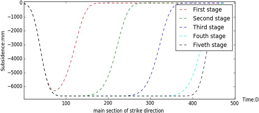
Dynamic simulation for the process of mining subsidence 833
CA modeling for subsidence simulation. For example, environmental, natural disasters, risk predictions, etc.
how to setup the CA model according to the coal mining As a powerful tool for highly complex geographical
technology and integrate the CA model with Geographic phenomena, many have continued to expand the
information system (GIS) tools to facilitate the ecological standard CA model by combining it with fractal theory,
restoration. the multi-factor evaluation model, artificial neural net-
This paper takes a mine in East China as a research works, Markov chain, and multi-agent, etc. [18–20].
area, analyses the methods and measures for developing
a model of mining subsidence based on the theories of
CA and mining technology, then discusses the results of
simulation from different aspects. The purpose of this 2.2 Mining subsidence CA model
study is to (1) establish a mining subsidence CA model
under a three-dimensional framework; (2) create a 2.2.1 Establishment of cellular space
mining subsidence CA model with the support of GIS
and Python; and (3) simulate the process of mining Mining subsidence prediction of the CA model relates to
subsidence by combining the spatial analysis and three- the surface cellular space and underground coal cellular
dimensional visualization functions of GIS. space. These two types of cellular space are constructed
With the help of CA, the result of the temporal and based on the unified spatial reference, and the evolution
spatial evolution of subsidence can facilitate the assess- of the underground cellular space drives the change of
ment of environmental impact and the optimization of the surface cellular space.
the mining plan. The work can promote the ecological
civilization in mining areas and has a wide application
prospect in the field of coal mining and land 2.2.1.1 Choice of cellular size
reclamation.
A smaller cellular size results in a higher calculation
accuracy. However, the calculation time increases rapidly.
According to regulations and previous research, suitable size
2 Study methodology can be chosen according to the mining conditions (Table 1).
2.1 CA
2.2.1.2 Work face cellular space
CA is a nonlinear system model with a complete discrete According to the mining plan, the cellular space of the
space, time, and state. It can be defined as the following mining working face is expressed as the following
quadruple [14–17]: formula:
A = (Ld , S , N , f ) (1) Ω = {Ci, j} (3)
where A is the CA system, Ld is a d-dimensional cellular where Ω is the mining work face cellular space set and
space, d is a positive integer; S is a discrete finite set of Ci,j is the cellular unit of the mining work face. The
cellular states; N is a combination of cellular states in the length of the mining work face is L, width is D, and the
neighborhood; and f is a local conversion function. size of cellular is d, then, i ∈ (i0, i0 + L/ d),
Evolution can be expressed as the following formula: j ∈ (j0 , j0 + D/ d), where i0, j0 is the origin of the work
face cellular code.
Sit,+j 1 = f (Srt, v ) r ∈ (i − n , i + n); v ∈ (j − n , j + n) (2)
where Sit,+j 1 is the state of the cellular unit (i,j) at time
t + 1; Srt, v is the set of all neighbors at time t, and n Table 1: Size of cellular for prediction
represents the distance of the neighborhood.
Compared with the traditional equation-based geo- Mining depth/m Size of cellular/m
graphic model, the CA model has better spatio-temporal 500 ≤16
linear systems. This tool is commonly used in ecology,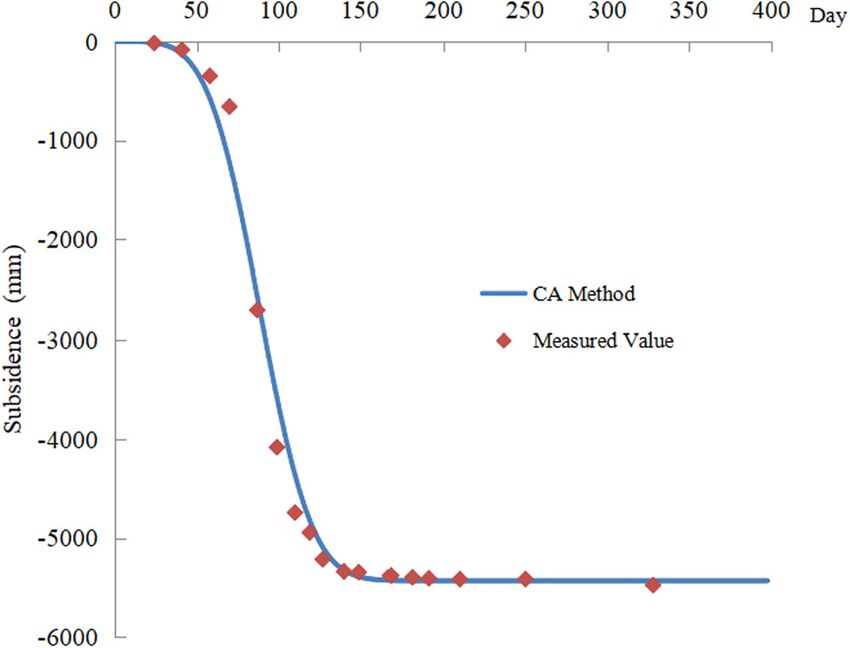
834 Qiuji Chen et al.
2.2.1.3 Surface cellular space w0 = mq cos(a) (7)
where m is the thickness of the coal seam, q is the
According to mining subsidence theory, the influence of
subsidence coefficient, and α is the angle of dip.
subsidence is in a specific area, and the distance to the
The state of the work face cellular unit at a given
boundary of the working face is the radius of influence of
time t can be described with the following formula:
mining subsidence (r). Based on this, the surface cellular
x
space range can be described with the following 2 2
formula: Cit, j =
π
∫ e−u du (8)
0
Φ = {Sm, n} (4)
where x is the time distance, which is dimensionless and
where Φ is surface cellular space set and Sm, n is a surface can be calculated with the following formula:
cellular unit, among which
m ∈ (i0 − 2r / d , i0 + (L + 2r )/ d), x = (t − t c)/ t0 (9)
n ∈ (j0 − 2r / d , j0 + (D + 2r )/ d). where tc is the mining moment of the coal cellular unit. If
the coal cellular unit is not mined at time t, then x is set
to 0. t0 indicates the time-effect distance and can be
2.2.2 Cellular neighborhoods calculated with the following formula:
t0 = r / v (10)
Neighborhoods play essential roles in CA models. The
evolution of the surface cellular state depends on the where v is the advancing speed of the working face and r
change of the cellular state of underground coal seams. is the main radius of influence.
Therefore, the neighbor space of the surface cells is defined
in the underground coal cellular space as well. The distance
of the neighborhood is determined according to the main 2.3 Accuracy testing
influencing radius r, that is, the neighborhood order k = int
(r/d + 1). So, for a given surface cellular unit Sm, n , its To verify whether this method is viable, the
neighbor cellular units are Ci, j , where predicted values are compared with in situ measured
j ∈ (n − k ), (n + k ), i ∈ ((m − k ), (m + k ). data (Figure 1). The value of subsidence is surveyed
with the instrument of electronic level according to
third class level requirements. The standard
deviation for in situ measured data is ±6 mm/km, so, it
2.2.3 Evolutionary rule construction
can be re guarded as the actual value to evaluate
the accuracy of prediction. Through correlation
The evolution rule reflects the interaction between the
neighboring cellular units and the central cellular unit
and is the basis for the automatic evolution of the
system.
For a given surface cellular unit Sm, n , its state Smt +, n1 at
the time (t + 1) depends on the state of the neighbor
cellular units Ci,j at a time (t). The transition is defined as
the following formula:
m+k n+k
Smt +, n1 = f (Cit, j) = ∑ ∑ (Cit, j ∗ Rim, j , n) (5)
i=m−k j=n−k
where Rim, j , n is the influence function of the neighbor units,
which can be described with the following formula:
2 2
1 −πd2 (m − i) +(n − j)
(6)
Rim, j , n = w0 2 e r2 d2
r
where w0 is the maximum subsidence value (unit: mm).
It can be calculated with the following formula: Figure 1: Distribution of predicted value and in situ measured value.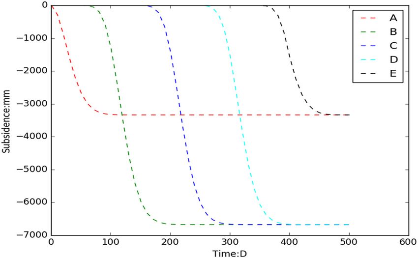
Dynamic simulation for the process of mining subsidence 835 Figure 2: System implementation flow chart. Figure 3: The layout of observation points. analysis, the correlation coefficient between the pre- the accuracy of the CA method meets the requirements dicted value and the in situ measured value is 0.99. So, for dynamic land reclamation planning.
836 Qiuji Chen et al.
object-oriented, interpreted computer programming lan-
guage with a rich and powerful library for rapid develop-
ment and efficient integration with other tools. ArcGIS 10
provides a Python site package (ArcPy), where GIS users
can quickly create simple or complex workflows with the
help of ArcPy in Python and develop utilities that can be
used to process geoscience data [21]. The implementation
process of the system is shown in Figure 2.
3.3 Results analysis
Figure 4: Changes in surface cells with mining.
3.3.1 The evolution of specific points with mining
3 Application
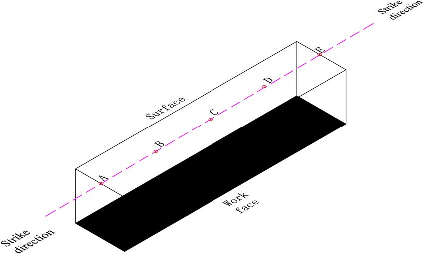
In this case, five points (A, B, C, D, E) on the main
section of the surface deformation are selected, which
3.1 Overview of case study
are shown in Figure 3. Mining started on the first day,
and the values of cellular units are analyzed within 500
The study area locates in the in Shandong Province, China. days, and the processes of subsidence with time are
The average thickness of the coal seam is 8.0 m. The burial shown in Figure 4.
depth is 320 m. The terrain is overall flat, with an average Initially, for a given cellular unit, the rate of
elevation of 44 m. The simulated working face has a length subsidence is slow, yet increases quickly when the
of 1,580 m along strike and a width of 350 m along dip. It will position of the working face moves to directly under-
be exploited with a fully mechanized mining method, and neath the surface cellular unit. After the working face
the working face will advance at a speed of 4 m/day. has passed the cellular unit, the subsidence rate then
Combined with the rock movement observation data of the slowly decreases until the end. The start of subsidence at
surrounding mines, the main influence angle tangent is 2 each point varies with time, as the distance to mining the
and the maximum subsidence coefficient is 0.84. working face directly affects the state. Therefore, treat-
ment for land reclamation can be selected based on the
predicted value. For example, the subsidence at point A
3.2 Implementation of the model approaches an end on the 90th day, at a total depth of
3,300 mm. This location can then be treated with a
Python and ArcGIS are integrated into the model to terrace after that day rather than waiting until the end of
implement the mining subsidence CA. Python is an all mining.
Figure 5: Changes in the amount of subsidence of the surface along the main section with the advancement of the working face.Dynamic simulation for the process of mining subsidence 837
3.3.2 Subsidence evolution along the main mining
section
Changes in subsidence along the main section at five-time
points (100th, 200th, 300th, 400th, and 500th day) were
selected to analyze the process of subsidence with
working face advancement. The amount of subsidence
and change in values along the main section during the
mining process is shown in Figure 5. During the
advancement of the working face, subsidence occurs
ahead of the working face, and the subsidence curve
continues to progress forward with the advancement of
the working face. Subsidence continues to develop even
after mining has ended. This figure also shows where the
basin and slope are distributed which can aid in the
proper selection of treatments as different regions require
different methods. Finally, the curve also shows when
subsidence end (Figure 5); therefore, timely reclamation
can be implemented to minimize the ecological degrada-
tion, or before the start of subsidence, some measures,
such as planting or drainage, can be applied to the region.
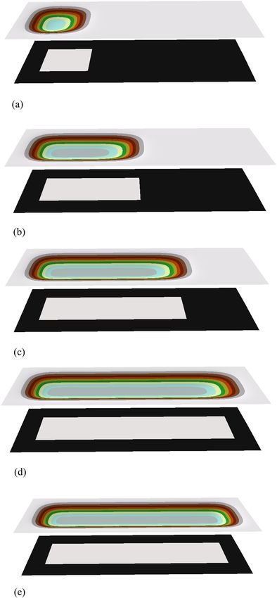
3.3.3 Changes in subsidence in the total surface
As the analysis of the above, 5-time points were selected
(100th, 200th, 300th, 400th, and 500th day) to analyze
the changes in subsidence of the surface across the
entire region. The calculation results are shown in
Figure 6 and provide an overall perspective of sub-
sidence throughout the mining process. The CA model
provides the area and depth of subsidence at various
times so that a plan for land use can be made in
advance. Based on the results, the quantities of earth-
work for land reclamation can also be calculated.
4 Discussion
(1) From the result of accuracy testing, it can be found Figure 6: Changes in subsidence of the surface over time across the
entire region: (a) 100th surface subsidence simulation, (b) 200th
that the predicted result is well consonant with the
surface subsidence simulation, (c) 300th surface subsidence
observation data. This indicates that the CA model is simulation, (d) 400th surface subsidence simulation, (e) 500th
in capacity to reveal the mechanism of mining surface subsidence simulation.
subsidence progress because the model is con-
structed based on the theory of non-continuous found. The function is to predict and assess the
media mechanics. The advantages of the CA model impact on the place needed to pay attention. Based
for mining subsidence are that it is easy to calculate on the result, it can be determined when to take
and can integrate the process with time. measures to control the damage and restore the land
(2) From the view of point change with mining, the use; from the view of line change with mining, the
evolution of subsidence on a detailed location can be shape and scope of subsidence with time can be838 Qiuji Chen et al.
found which can facilitate the farmland and struc- a new idea for subsidence simulation, but the
ture lays out. Through compared with relevant subsidence evolution model under complex geolo-
research findings [22,23], the spatial scope and gical mining conditions still needs further study.
shape of the CA method are consistent with other
methods; from the view of area change with mining,
the overall perspective of the surface subsidence Acknowledgments: This work is financially supported by
evolution can be obtained, which can help to fully the Research Project of Key Technologies for Water
understand and master the impact of subsidence. Resources Protection, Utilization, and Ecological
(3) The CA model can integrate with the software of GIS Reconstruction in Northern Shaanxi Coal Mine Area
which provides many useful tools for data manage- (SMHKJ-A-J-03:2018).
ment and visualization. Moreover, it is simple to
conduct a correlation analysis between other spatial
data by GIS tools.
References
[1] Zhang B, Cui XM, Zhao YL, Li CY. Prediction model and
algorithm for dynamic subsidence of inclined main section.
5 Conclusions J China Coal Soc. doi: 10.13225/j.cnki.jccs.2019.1814.
[2] Zhang B, Cui XM, Hu QF. Study on the normal distribution time
This paper discusses simulating the process of surface function model of mining subsidence dynamic prediction. Coal
Sci Technol. 2016;44(4):140–5. doi: 10.13199/
subsidence based on the CA model, which provides a
j.cnki.cst.2016.04.028.
powerful tool and theoretical basis for dynamic reclama- [3] Zhang K, Hu HF, Lian XG, Cai YF. Optimization of surface
tion. The main innovations achieved are as follows: dynamic subsidence prediction normal time function model.
(1) The mining subsidence is affected by many factors Coal Sci Technol. 2019;47(09):235–40. doi: 10.13199/
and it is a complex progress. The CA model has the j.cnki.cst.2019.09.030.
ability to simulate complex systems. The CA model of [4] Chen QJ, Zhang Y, Tian LX. Dynamic reclamation for damaged
land based on residual deformation of coal mining sub-
mining subsidence evolution in three-dimensional
sidence. Coal Technol. 2019;39(01):4–6. doi: 10.13301/
space is constructed based on mining subsidence j.cnki.ct.2019.01.002.
theories. The cellular space division, neighborhood [5] Wei T, Wang L, Chi SS, Li N, Lv T. Research on dynamic precise
definition, evolution rules, and other aspects of the prediction method of mining subsidence based on aged
model are defined according to the condition of coal knothe function. Met Mine. 2017;(10):16–22. doi: 10.19614/
j.cnki.jsks.2017.10.004.
characteristics and mining technology. The result is
[6] Zhang JM, Xu LJ, Li JW, Shen Z, Yu LR. Study on dynamic
tested with in situ measured value and has high subsidence model of mining subsidence and its parameters.
accuracy. The evolution results reflect the process of Met Mine. 2017;(10):12–5. doi: 10.19614/
surface subsidence and provide a basis for preparing j.cnki.jsks.2017.10.003
reclamation measures before the initiation of mining. [7] Mohammad M, Mahdi K. Investigation of the effect of
(2) The system of mining subsidence evolution CA is dimensional characteristics of stone column on load-bearing
capacity and consolidation time. Civ Eng J.
developed with the support of ArcGIS and Python,
2018;4(6):1437–1146. doi: 10.28991/cej-0309184.
which can help to realize data management, [8] Chen QJ. Simulation of coal mining subsidence based on the
visualization, and spatial analysis. The process of model of cellular automata. Sci & Technol Rev.
mining subsidence is demonstrated from three 2013;31(11):65–7.
levels, point, line, and surface by combining the [9] Sun XY, Xia YC. Dynamic prediction model of mining
subsidence based on cellular automata. Adv Mater Res.
model with a case study of a mine in eastern China.
2014;962–5:1056–61. doi: 10.4028/www.scientific.net/
The spatial scope and shape of the CA method are amr.962-965.1056.
consistent with other methods. The dynamic evolu- [10] Chen QJ. Dynamic prediction for mine subsidence along major
tion of subsidence provides a basis for constructing a profile based on cellular automata. Electron J Geotech Eng.
reclamation program. 2017;22(10):4225–34.
(3) The precision of the simulation could be improved [11] Davide F, Marco T, Stefania V. Response site analyses of 3D
homogeneous soil models. Emerg Sci J. 2018;2(5):238–50.
by decreasing the cell size. For a mine area with a
doi: 10.28991/esj-2018-01148.
large space, this would significantly increase the [12] Elmira N, Hadi F. The effect of suffusion phenomenon in the
amount of data and dramatically increase the increasing of land subsidence rate. Civ Eng J.
amount of calculation time. The CA model provides 2016;2(7):316–23. doi: 10.28991/cej-2016-00000036.Dynamic simulation for the process of mining subsidence 839
[13] Liu WT, Xie XX, Liu H, Zhao HJ. Analysis of multi-seam mining systems -a human-environment relationship perspective. Int J
subsidence dynamic prediction. Safety Coal Min. Geographical Inf Sci. 2019;33(11):2241–58.
2016;47(10):228–230+234. doi: 10.13347/ doi: 10.1080/13658816.2019.1622015.
j.cnki.mkaq.2016.10.061. [19] Gao C, Feng YJ, Tong XH, Jin YM, Liu S, Wu PQ, et al. Modeling
[14] Tong XH, Feng YJ. A review of assessment methods for cellular urban encroachment on ecological land using cellular auto-
automata models of land-use change and urban growth. Int J mata and cross-entropy optimization rules. Sci Total
Geographical Inf Sci. 2020;34(5):866–98. doi: 10.1080/ Environ. 2020;(07):149006. doi: 10.1016/
13658816.2019.1684499. j.scitotenv.2020.140996.
[15] Cao Y, Zhang XL, Fu Y, Lu ZW, Shen XQ. Urban spatial growth [20] Zhang YH, Qiao JG, Liu WH, Cai SR, Ding QX, Chen XW.
modeling using logistic regression and cellular automata: a Parameter sensitivity analysis of urban cellular automata
case study of Hangzhou. Ecol Indic. 2020;113:106200. model. J Remote Sens. 2018;22(6):1051–9. doi: 10.11834/
doi: 10.1016/j.ecolind.2020.106200. jrs.20187145.
[16] Feng YJ, Tong XH. A new cellular automata framework of urban [21] Li SY, Deng JQ. Automated processing and analysis method of
growth modeling by incorporating statistical and heuristic geoscience data based on ArcPy. Technol Innov
methods. Int J Geograph Inf Sci. 2020;34(1):74–97. Product. 2018;03:44–46. doi: 10.3969/j.issn.1674-
doi: 10.1080/13658816.2019.1648813. 9146.2018.03.044.
[17] Zhou X, Zhang RL, Zhong ZY, Guo SL. Developing a hydrology [22] Tan ZX, Deng KZ. Theory and practice of coal mining under
coupled 2D cellular automata model for efficient urban flood buildings. Xuzhou: China University of Mining and Technology
simulation. IOP Conf Series: Earth Environ Sci. Press; 2009.
2019;304(2):022050. doi: 10.1088/1755-1315/304/2/022050. [23] Wang ZS, Deng KZ. Richards model of surface dynamic
[18] Li Y, Hu BS, Zhang D, Gong JH, Song YQ. Flood evacuation subsidence prediction in mining area. Rock Soil Mech.
simulations using cellular automata and multiagent 2011;32(6):1664–8.You can also read