Environmental Flows Assessment in India: The Ganga Experience
←
→
Page content transcription
If your browser does not render page correctly, please read the page content below
Case Study 1

Environmental Flows
Assessment in India:
The Ganga Experience

                                   Nitin Kaushal and Suresh Babu

                                      Background
               Rivers in India are losing their life. Many of them are running
               dry due to over abstractions while others are getting reduced
               to wastewater drains because of pollution.
                      River Ganga is a lifeline to about 500 million people
               inhabiting its basin. The river Ganga provides water for
               drinking, domestic needs, agriculture, livelihoods, industrial
               use, fishing, boating, recreation, religious, cultural activities
               and for energy. Besides the humans, the river supports rich
               fauna and flora, including the endangered Ganges river
               dolphin (Platanista gangetica gangetica), at least nine other
               species of aquatic mammals, reptiles (including three species
               of crocodiles along with one species of monitor lizard (Varanus
               bengalensis)) and different freshwater turtles. This mighty
               river also has the richest freshwater fish fauna anywhere in
               India.
                      The ecosystem integrity and the goods and services
               offered by the river are getting adversely affected by the
               changes in its water quality and flow regime. Reasons are
               many: In the Himalayan reaches, until Rishikesh the flow in
               the river is threatened by water abstractions for existing and
               proposed hydropower projects. With many dams and barrages
               the river has become lean over the years, with 60% of its water
               being diverted before it enters the plains. About 12 billion
               litres of wastewater are released into the Ganga every day and
               80% of this is untreated. As the river’s dynamics have been
               altered by diversions and unproductive uses, the freshwater
               flow has reduced, resulting in a reduction in the assimilative

                                                   E nv iro n men ta l F lo w s   | 207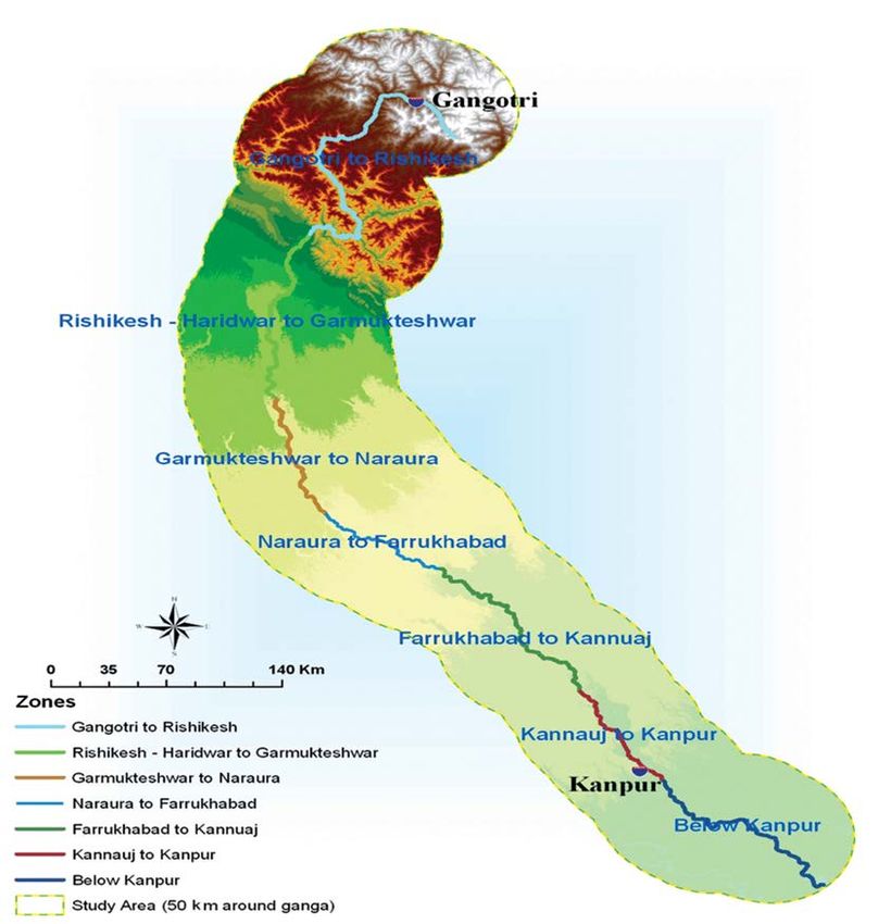
capacity of rivers. This has led to a rise in the pollution load. A study by the Central Pollution
Control Board in 2007 showed that Ganga contributed to 40% of the polluted river stretches
in India. Changing consumption patterns, growing water footprint of cities, industries and
agriculture, Ganga and its ecosystem will only aggravate the situation. Business as usual
will see more water being consumed, more waste being generated and severe ecological
degradation of our rivers.
       While the impact on society and livelihoods is becoming more and more evident, it
is also important to realise that the river habitats are controlled by physical processes—
flow, water quality, sediment transport. Managing (or mis-managing) the flow, can lead to
significant changes to the biodiversity of rivers.

Environmental Flows: A Driver
The current paradigm of river conservation programmes in India focuses mostly on sewage
and industrial pollution management and no attempt is made to treat the river ecosystem
as a whole. Various challenges that rivers face today reinforce the necessity to consider
implementing environmental flows (or E-Flows) in water resource management and for
improving the river health.
       E-Flows are increasingly recognised as a key to the maintenance of ecological integrity
of the rivers, their associated ecosystems and the goods and services provided by them. The
assessment of E-Flows aims to identify the quantity, quality and distribution of flow patterns
(timing) along the length of a river and provides a balance between the use and protection of
natural water resources for people and biodiversity. E-Flows are multidimensional and their
assessment is both a social and technical process. Social, as it depends on what the society
wants a river to do for them-to support culture and spirituality or livelihoods or biodiversity or
all the above functions and more. Multi-disciplinary technical processes are required to carry
out detailed studies relating to hydrology, hydraulics, geomorphology, pollution etc. While
many countries in the world today have an E-Flows policy, the debate in India has graduated
from a rather narrow focus on ‘minimum’ flows to a much comprehensive ‘environmental’
flows. The debate on how much water is needed to sustain riverine ecology is catching up
momentum with each hydro-electric project being introduced.

                                 WWF’s work on E-Flows
Globally WWF (World Wide Fund for Nature) has been promoting the concept of E-Flows
since 2000. However, in India the WWF started studies on E-Flows during 2007-2008.
Various stakeholders, including the government, water managers, researchers, scientists,
civil society organisations and social experts did not have any case specific and tested
methodology to understand a comprehensive process of E-Flows assessment in the country.
Therefore, WWF-India initiated the first of its kind attempt to develop a methodology and
assess the E-Flows in the Upper Ganga basin, within the framework of its Living Ganga
Programme (2008-2012). There were many challenges of which the critical ones were:
      1.     Technical: How to define E-Flows in the context of the Ganga which has a socio-
             cultural religious dimension (besides its hydrological, hydro-geomorphological

208 | Env iro nment a l Flo ws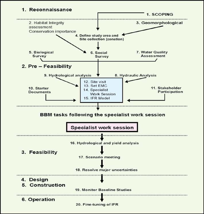
and quality significance)? Globally, none of the methodologies available for the
            estimation of environmental flows had a cultural dimension. Given the socio-
            cultural importance of the river, selection of a methodology that could capture
            the complexity of issues was a daunting task. Further, there was very little
            hydrological data available for the assessment of flows as most of such data are
            ‘Classified’.
      2.    The second major challenge was the lack of capacity within WWF and in the
            country to develop work on E-Flows assessment.
      3.    As in any other initiative, creating awareness, building consensus and a buy-in
            from different stakeholders on the need for environmental flows was always a
            major area of work. It must be remembered that the debate in the context of flows
            was limited to ‘minimum’ flows and there was a huge gap in the understanding
            of E-Flows.

       WWF partnered with several national and international institutions/organizations
to undertake this study. The international partners were UNESCO – IHE, the Delft
Netherlands, and International Water Management Institute – Sri Lanka and at national
level, the partners were the IIT – Kanpur, INRM Consultants, IIT – Delhi, Delhi University,
People’s Science Institute and Srinagar Garhwal University. Several individual experts
also contributed to this work. Over more than three years, WWF-India and its partners
debated, discussed, developed and field tested a holistic approach towards environmental
flows assessment suited for the Upper Ganga basin. The 800 km stretch from Gangotri to
Kanpur was selected for the study because it illustrates almost all the challenges the river
Ganga faces across its entire journey. Abstractions or diversions (run-of-the-river dams
and irrigation systems), obstructions (reservoir based dams), and critical pollution (both
industrial and municipal) are all evident within this stretch. Further, this stretch is also
known for rich biodiversity.

Objectives of the Assessment
The objective to undertake E-Flows assessment for Upper Ganga was two pronged;
      a)    to improvise one of the existing holistic methodology (in this case the Building
            Block Methodology (BBM)) to suit an Indian river conditions and pilot test the
            same for assessment of E-Flows for a river as mighty as Ganga;
      b)    to build the capacity of local experts in regard to undertaking assessment of
            E-Flows through a holistic methodology
       The overall goal of E-Flows work under the Living Ganga Programme was not only to
mainstream the concept of E-Flows in formal dialogue around river basin management, but
also to showcase the suitability and applicability of the developed holistic methodology for
Indian rivers. Plus it was also envisaged that, the local partners whose capacity got built and
strengthened (in regard to E-Flows assessment) during this process will undertake similar
exercises in other river basins of the country.

                                                                   E nv iro n men ta l F lo w s   | 209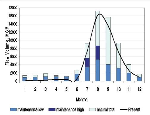
This paper summarises the process involved, templates for technical assessments
and the lessons learned. The underlying principle of the effort was that E-Flows are
multidimensional and that its assessment is both a social and technical process, with a
social choice at its core. Hence, the WWF brought together civil society groups, Indian and
international experts (hydrologists, geomorphologists, ecologists, hydraulics engineers,
and sociologists) and Government departments to sit together, deliberate and develop
a methodology for assessment. It started off with an intense capacity building process
targeting WWF staff and its partners. International experts with experience on E-Flows
facilitated this process. For detailed report, see O’Keeffe et al. (2012).

            Environmental Flows Assessment Methodology
WWF decided to consider a holistic methodology so that a concerted and comprehensive
view of various aspects of the river can be taken care of, especially respecting the uniqueness
of the Ganga and its socio-cultural importance. Amongst various holistic methodologies, the
Building Block Methodology (BBM) was found to be best suited for Indian conditions due
to following reasons:
1.    It is a robust and well-defined methodology with detailed manual explaining step-by-
      step process for assessment of E-Flows.
2.    It is a flexible methodology and one can tailor it to suit local conditions, for instance
      – in the case of river Ganga, the socio-cultural aspects are of immense vitality, so any
      E-Flows assessment exercise needs to take care of this and BBM provided that room,
      so that the integration of socio-cultural aspects could be done.
3.    This multidisciplinary methodology can work well in data-rich and data-deficient
      conditions, which made this methodology all the more appropriate for river Ganga,
      as Ganga is a trans-boundary river and availability of its hydrological data in public
      domain has always been a challenge.
4.    It is a bottom-up approach where each motivation for recommended flows is carefully
      motivated and well defined.
5.    It is one of the most frequently used holistic methodology around the world
      A step-by-step process chart of the BBM illustrating various steps is given in Figure 1.
      The details of methodology are described by King et al. (2000).

            Environmental Flows Assessment – The Process
The assessment of E-Flows for the upper Ganga stretch included several sub-studies. These
studies and the overall process to arrive at the recommendation of E-Flows are discussed below.

Homogenous Zonation Study
The exercise of E-Flows assessment for river Ganga began with a study to classify the upper
Ganga into various zones on the basis on homogeneity, elevation, anthropogenic activities

210 | Env iro nment a l Flo ws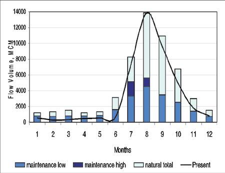
Figure 1. BBM procedures followed in the assessment of E-Flows

and other physiological characteristics of the river. The zonation of the 800 km Upper
Ganga was confined primarily to the mainstream, however the floodplains of the river,
using a buffer of 50 km on each side of the main river channel, were also considered to
provide a general description of the major physiographic and geomorphologic features and
the modifications/ alterations along the river. For this study, the WWF partnered with the
INRM Consultants (Integrated Natural Resources Management Consultants Pvt. Ltd.1).
      The methodology to undertake this zonation exercise included a desk-top study to:
      •     Analyse the changes in river morphology
      •     Analyse land use changes over the flood plain area
1
 INRM is a R&D based company set up under Technology Business Incubation Plan of the Indian
Institute of Technology (IIT) Delhi by the faculty and alumnus of the institute in 2001.

                                                                    E nv iro n men ta l F lo w s   | 211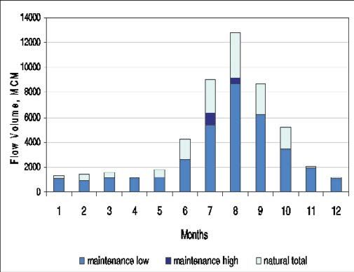
•        Identify the confluences of major tributaries, man-made structures such as
                barrages and other diversions, potential point sources of pollution, meandering
                and stable sections, etc.
       •        Collate secondary data on cities, industries, pollution monitoring sites, etc.
     This analysis utilised satellite imageries to obtain the land use information. The terrain
was analysed from the Shuttle Radar Topography Mission (SRTM) data (90 m resolution).
      Through this study, it was concluded that the river Ganga can be classified into seven
distinct zones, i.e.
       Zone 1: Gangotri to Rishikesh
       Zone 2: Rishikesh to Garhmukteshwar
       Zone 3: Garhmukteshwar to Narora
       Zone 4: Narora to Farrukhabad
       Zone 5: Farrukhabad to Kannauj
       Zone 6: Kannauj to Kanpur
       Zone 7: Downstream of Kanpur (Kanpur to Rai Bareilly)

       These zones are shown in Figures 2a and 2b.

Methodology Workshop
During the ‘Methodology Workshop’ in December 2008, decision was taken to further
narrow the approach from seven zones to four zones. These four zones were identified for
actual consideration and further studies as the four zones are able to represent the critical
challenges of the river Ganga. Table 1 lists the location of the four zones, their critical issues
and representative sites. More details are given below.

       Table 1. Four zones representing critical issues pertaining to river Ganga and study sites

 S.                  Zone                Critical aspects/Issues        Site (latitude and longitude)
 No.

 1         Zone 1: Gangotri to       A mountainous sub-stretch         Kaudiyala [N30°04’29.9”,
           Rishikesh                                                   E78°30’09.9”]

 2         Zone 2: From upstream     A sub-stretch which is            Upstream of Narora
           of Garhmukteshwar to      relatively intact                 (Reference Site)
           Narora (Reference Zone)                                     [N28°10’51.2” E78°23’51.2”]

 3         Zone 3: Narora to         A sub-stretch which is affected   Kachla Ghat [N27°55’59.8”,
           Farrukhabad               by water abstraction through      E78°51’42.5”]
                                     barrage

 4         Zone 4: Kannauj to        A sub-stretch which is affected   Bithoor [N26°36’51.9”
           Kanpur                    by pollution                      E80°16’28.6”]

212 | Env iro nment a l Flo ws
Figure 2a. Project area of Living Ganga Programme showing the Upper Ganga River stretch E nv iro n men ta l F lo w s | 213
Figure 2b. Upper Ganga River stretch showing various zones

214 | Env iro nment a l Flo ws
During a meeting in February 2009, one site under each of the zone was selected with
a view to undertake detailed field investigations, surveys and associated research. The idea,
again, was the representativity of the respective zone by the identified site. Table 1 lists the
sites identified for detailed field investigations are listed in Table 1 and described below briefly.

Site: KAUDIYALA (Zone: Gangorti to Rishikesh)
Kaudiyala is located about 12 km downstream of Devprayag (where the Alaknanda and
Bhagirathi rivers meet to form the Ganga River). The river has a very sharp bend at this
location, with gravels and boulders on the concave side, and a road along its right bank. The
river is about 100 m wide at this point, while the valley width is in excess of 600 m. The river
is flanked on both sides by high mountains. Two reservoirs are planned between this point
and Devprayag which are likely to disturb the ecology of the reach significantly, making it an
even more important site for an E-Flows assessment.
     The channel consists largely of pool/riffle and rapid sequences. The narrow channel
widens as the river enters Kaudiyala, forming sandy banks along the left slopes. The dominant
sediments carried by the river are gravels, with the river bed at this point consisting of
boulders, rocks, cobbles, pebbles and silt.
      In the reach between Kaudiyala and Marine Drive (upstream of Lakshman Jhula and
Rishikesh), large boulders are common along both banks, suggesting that rock slides are
frequent in this area.
       In this zone, the biodiversity and cultural and spiritual aspects are highly significant,
a brief description of which is given below.
       A few kilometers upstream of this site, at Pachelikhal, is the confluence of the Nyar river
with the Ganga. It is believed that the Nyar is the only tributary of the Ganga in which mahseer
(fish) breed in the monsoon period when the flow in the Nyar is conducive. The construction
of dams and hydropower plants in the downstream reaches may change this situation, as the
adult mahseer may not be able to migrate upstream to reach the Nyar for breeding.
      Downstream of Kaudiyala, a good population of large mahseer was observed at
Rishikesh (Ram Jhula) concentrated in the centre of the channel with a gravelly bed and
shallow water depth. Along the right bank, the rocky bottom was visible but the deeper
water did not encourage the fish population.
      The site at Kaudiyala was subsequently found not to be suitable for biodiversity
sampling because of a lack of available habitats. Therefore, an alternative site at Shivpuri,
10 km downstream of Kaudiyala, was used for the biodiversity study. The water quality and
temperature were similar at the two sites, whilst Shivpuri provided a greater diversity of
more accessible habitats. Since both Kaudiyala and Shivpuri are suitable for assessing the
riparian vegetation, the biodiversity group decided to carry out their surveys and sampling
along the stretch of river from Kaudiyala to Shivpuri.
       There are a number of tourist camps in this area, which are very popular with visitors
for rafting and camping. Plus, Rishikesh is one of the crucial towns from the perspective of
socio-cultural and religious aspects.

                                                                       E nv iro n men ta l F lo w s   | 215
Site: U/S Narora Barrage (Zone: U/S of Garhmukteshwar to Narora)
The Baiya and Burh Ganga are the major tributaries joining the main channel. The Lower
Ganga Canal take off at Narora barrage which is located in this zone. Channel morphology
around this site includes sand bars, islands, flat floodplains and a few ox-bow lakes. The
floodplain on the left bank is wider than on the right bank.
This stretch has adequate flows and water depths are sufficiently well maintained to
support natural biodiversity and especially the flagship species such as river dolphin and
gharial. This stretch is also a declared ‘Ramser Site’. Plus this stretch also doesn’t face
significant pollution load. In view of all this, this zone was decided as a ‘reference-zone’
to benchmark and assess the downstream zones, which have been very heavily modified,
overused and polluted. This means E-Flows assessment for this site representing the
respective zone was not undertaken.
Site: Kachla Ghat (Zone: Narora to Farrukhabad)
This site is located approximately 60 km downstream of Narora, at downstream of the
confluence of the Mahuwa with the Ganga River. The Central Water Commission (CWC) has
a hydrological station (GDSQ) at this site, where water level, discharge, sediment load and
water quality are measured. The river macro-channel at this location is very wide (>3 km)
but the water is confined to only about 20 m and the water depth is 1 to 2 m (waist deep) at
present. Both the banks of the river are quite flat, merging gradually with the floodplain. No
sign of any incision was visible on either of the banks. The dominant grain size of channel
sediments is fine sand with significant amounts of silt.
Upstream of this site, the Mahuwa River at Jatki village has a much larger valley
than the channel occupied by the river at present, suggesting a significant reduction in
river discharge in recent times. The river was almost dry at the time of the initial field visit
(March), with the river bed being cultivated by local melon farmers, and fishing taking place
in the remaining pools. Field investigations revealed that a large amount of effluent from
Gajraula is discharged into the Mahuwa, eventually finding its way into the Ganga River
downstream of the confluence. Even though the flow from the Mahuwa is diverted, the
Ganga River at Kachla Ghat seems to have several other sources of pollution such as city
waste. It has a cremation area/ghat as well as a bathing ghat.
Due to intense human activity at Kachla Ghat, this site was not suitable for the study of
aquatic biodiversity, and a better site was selected 1 km downstream where micro-habitats
and stable substrate are available. Agriculture is the major form of human impact especially
along the right bank.
Kachla Ghat’s religious importance is not of extraordinary spiritual significance
as in the case of Haridwar and Rishikesh, but is important from the point of view of
livelihoods. Several livelihood practices that depend on in-stream flows are evident here,
including farming on sand banks, ferrying, retrieving coins, pilgrimage, ritual bathing
and cremation.
216 | Env iro nment a l Flo wsSite: Bithoor (Zone: Kannauj to Kanpur)
Bithoor (situated at upstream of Kanpur), was selected as the designated site for detailed
studies in this zone. The surface elevation at Bithoor is 120-130 m above mean sea level. The
active channel presently follows the southern valley margin and has extensive floodplain
areas within the valley. Floodplain areas north of the Ganga include abandoned channels,
meander scars and ox-bow lakes, together with a few small lakes and waterlogged areas. A
very large, conspicuous meander scar which is presently cut off from the present channel
is periodically flooded by the Ganga. The southern valley margin is strongly incised and at
Bithoor, prominent cliffs up to 15 m high extend in a south-easterly direction for nearly
2 km. The river bed is mainly composed of sand and clay (on the banks of the river). Except
during the monsoon months, the river is multi-channeled, with large bars in the channel
dividing the flow.
The Kanpur barrage constructed 6 to 7 years ago is located immediately downstream
of this site, together with a diversion canal for the barrage. A hydrological station located
at Kanpur reports that the long-term average annual discharge at Kanpur is 1679 m³/s.
Hydrological data published for this station suggest that the discharge variability is
significant whereas the flooding intensity is low, with a higher bankfull discharge compared
to the mean annual flood.
At the site, the aquatic biota and especially the lower organisms (plankton and benthic
invertebrates), which are very sensitive, are highly influenced by intense anthropogenic
activities, including bathing, pilgrimage activity and boating. The site has religious and
archaeological importance. An old temple dedicated to Lord Brahma is situated at Bithoor.
Religious fairs are organised on important occasions, during which religious bathing is
common. The site is also known for historical remains of the pre-British period all along the
banks. Many local livelihoods depend directly on the cultural importance of this stretch of
the Ganga. Whilst this is a good site for generating hydraulic sections, as the right bank is
confined by 12 to 14 m high cliffs whereas the left bank is flat, it was not considered suitable
for aquatic (biodiversity) sampling. Aquatic sampling was carried out approximately 1 km
downstream of the Bithoor temple.
Objective Setting Workshop and Preliminary Field Visits
With a view to do the ground truthing exercise the group undertook extensive field visits
(March 2009) to all the sites to validate the findings of the initial studies and to reinforce
the decisions taken about the site selection etc. All the local potential partners accompanied
these visits. After these visits, an ‘Objective Setting Workshop’ was organized. During
this workshop, various critical aspects were discussed and concluded for further work.
Thereafter, a multidisciplinary team was set up to undertake detailed field investigations
pertaining to the critical aspects. Table 2 lists various critical aspects and partners who
undertook respective tasks.
E nv iro n men ta l F lo w s | 217Table 2: Critical aspects (tasks) and entrusted institutions/
organizations who undertook the same
S. No. Task (critical aspect) Partner undertaking the task
1 Overall facilitation UNESCO – IHE, the Delft
WWF – India
IWMI – Sri Lanka
2 Hydrology IWMI – Sri Lanka
3 Fluvial geomorphology IIT – Kanpur and Delhi University
4 Hydraulic modeling INRM Consultants and IIT – Delhi
5 Livelihood and economic aspects IIT – Kanpur
6 Socio-cultural aspects PSI – Dehradun
7 Establishing habitat preferences of Srinagar Garhwal University
selected aquatic vertebrates (biodiversity WWF-India
aspects)
8 Analysis of water quality and pollution IIT – Kanpur
During this workshop, the Environment Management Class (EMC) of the river was
also discussed and based on the international experience and local inputs it was concluded
that following EMC would be taken into consideration while defining the EMC for Ganga:
Six classes of river condition or health, A to F, are recognized. These are designated
as the Present Ecological State (PES) according to the current state. From these the overall
objective conditions, summarized as the EMC are defined from A to D. Class E and F are not
considered to be sustainable, and are therefore excluded as potential objectives):
Class A: close to natural condition
Class B: largely natural with few modifications
Class C: moderately modified
Class D: largely modified
Class E: seriously modified – no longer providing sustainable services
Class F: critically modified – no longer providing sustainable services
These EMCs are important to understand as most of the thematic groups (including
biodiversity, socio-cultural, fluvial geomorphology, livelihoods and economics) who
investigated sites/zones of the river Ganga did categorize sites/zones as per these EMCs,
except for the water quality group, who considered CPCB (Central Pollution Control Board
– India) classification of water quality.
218 | Env iro nment a l Flo wsDetailed Field Investigation
With the establishment of various thematic teams, detailed field investigations began
by respective teams in and around the sites identified under each of the four zones. This
exercise was aimed to capture changes/modifications/transformations within the respective
aspect in an annual cycle (pre, during and post monsoon), i.e. the field work continued for
a complete one year, i.e. from May 2009 to April 2010. During this period, tri-monthly
progress review meetings were conducted to keep track of the work related progress and
for course correction, if any. During these meeting the thematic groups used to present past
three months progress along with the plan for next 3 months to the rest of the group, so that
potential synergies, if any, could also be established.
Some of the thematic groups not only concentrated at the sites, but at the nearby
towns and points so as to capture the related aspect in totality. For instance – Kaudiyala
site is not of immense socio-cultural importance, so the socio-cultural group, in addition to
this site, also undertook field surveys in Rishikesh-Haridwar to capture the socio-cultural
aspirations of the visitors, pilgrims, and local people from these towns. Same is the case
of biodiversity group, who, while establishing the habitat preferences for selected species,
also analysed and investigated the upstream and downstream stretch of the river, so as to
understand the migratory/breeding/feeding pattern of the aquatic species.
Preparation of ‘Starter Document’ and other Thematic Reports
Later on, during March 2010 most of the thematic teams (Biodiversity, Fluvial
Geomorphology, Socio-Cultural, Livelihoods and Economic and Water Quality) submitted
individual ‘Starter - Documents’. The Starter – Documents actually reported following items
from a given perspective :
1. Present state of river, i.e. categorization of river state into most suitable EMC
(whereas in case of Water Quality group, the CPCB classification of water quality
was referred to)
2. Desired state of river, i.e. categorization of river state into most suitable EMC
(whereas in case of Water Quality group, the CPCB classification of water quality
was referred to)
3. Motivations for recommending respective desired state/class of river.
On the other hand the hydrology group prepared a detailed report on the ‘Hydrology
of the river Ganga’. For the purpose of hydrological modeling the thematic group required
the hydrological data in time series manner which was not available in the public domain,
due to trans-boundary nature of the river. However, in absence of that, the team managed
with scattered hydrological data which was made available from other sources (like – local
irrigation department and global datasets). Nevertheless, this report formed the basis for
other thematic groups to validate and cross check the viability of the recommended E-Flows
during the E-Flows setting.
E nv iro n men ta l F lo w s | 219The group undertaking hydraulic modeling and cross sectional work presented a
detailed report explaining surveyed cross sections of various sites. They actually took three
cross sections at each of the identified site; i.e. one at the upstream of the identified site,
second at the site and third at the downstream of the site. The findings of this report were
used by rest of thematic groups (excluding hydrology group) to arrive at required E-Flows
for specific sites.
E-Flows Setting
A five-day ‘E-Flows Setting Workshop’ was organized in mid 2010 (May 2010), during this
workshop the final E-Flows recommendation were arrived at.
This workshop had an exhaustive agenda to capture all the sites (representing
respective zones), taking care of all the concerned aspects for all the seasons, i.e. wet and
dry season, also the drought and floods scenario.
The first day of the workshop was devoted to field visit to Kaudiyala site, where both
the hydrology and hydraulics group members explained respective aspects at that site. Rest
of the thematic groups explained their respective requirements pertaining to the desired
state at this site. This visit was aimed at setting the context for all the thematic groups for
upcoming in-door exercise of setting E-Flows.
After the presentation of hydrology of river Ganga and hydraulic cross sections of
various sites, the larger group discussed wettest and driest months of the year and it was
concluded that based on the available data, January can be considered as a driest month and
August can be considered as a wettest month of the year.
Based on these decisions, the rest of thematic groups filled individual ‘Flow Motivation
Forms’. These forms were filled by each of thematic group for each of the season and for each
of the site. The groups also filled separate forms for extreme drought and flood conditions.
With a view to give an idea, one such form is shown in Figure 3. Through this form, each of
the group recommended E-Flows for specific site and for a specific season; the group also
gave associated motivations for recommending the flows, depth and average velocity along
with the consequences of not providing the same
Prior to filling of Flow Motivation Forms, the concept of ‘Maintenance Year’ was
explained. The Maintenance Year is a normal year, not very wet not very dry, when one
would expect all the ecological functions and processes (fish breeding, inverts emerging,
floodplain wetlands full, sediment transport etc.) to be working properly. Based on the part
hydrological datasets, it was concluded that, the Maintenance Flows would be equaled or
exceeded during 70 years out of 100; however, flows would be lower for 30 years out of 100
or in other words, 70% probability on a Flow Duration Curve. So, for long-term E-Flows, the
water volume required would be at maintenance recommendations or higher for 70% of the
time, and between drought and flood for 30% of the time.
The recommendations from the concerned thematic groups were discussed and
debated, and as expected, there were conflicting views in regard to recommended E-Flows
for a site and for a season by various thematic groups. At this juncture, the key facilitator
220 | Env iro nment a l Flo wsFLOW MOTIVATION FORM
River: Ganga Date: 11-05-10 Site: Kaudiyala Specialist: Geomorphology
Month: January Low flow or flood? Low Flow (MAINTENANCE Year)
Discharge: 400 cumec Depth: 9.5 m Average Velocity: 0.64 m/s
Reasons for recommending this flow:
At low flow, maintenance of longitudinal connectivity will be critical. Otherwise, the
geomorphology is in good condition. According to the cross section (CS-3), plan form
parameters along longitudinal direction and field observation, longitudinal connectivity
will be lost at a flow lower than 397m (RL) (depth 9.5 m), while water level at 404 m RL
will be good to maintain lateral connectivity. Since, discharge of 1400 cumec at 404 MSL
is unrealistic, lateral connectivity cannot be maintained at low flows. Hence, the final
recommendation at low flow is 9.5 m of flow depth (400 cumec discharge)
Consequences of not providing this flow:
Flow less than 400 cumec (corresponds to 9.5 m flow depth) will break the longitudinal
connectivity and will be critical for movement of biota. Water level less than 404 m will
break the interaction between channel and adjoining bars which is an implication for
nutrient supply and habitat conditions apart from the general functioning of the river
system.
Figure 3. A filled flow motivation form of fluvial geomorphology group for Kaudiyala site for dry
season – maintenance year
from UNESCO-IHE, Prof. Jay O Keeffe played critical role and asked the groups that, why do
they need such flows and if that is to be curtailed then to what extent, so that it does not lead
to detrimental impact onto the required aspect. Finally, the consensus about recommended
E-Flows was built for each of the site and for each of the season with clear rationale. The
same for different seasons were collated and concluded as recommended E-Flows in terms
of ‘Mean Annual Runoff’ (MAR).
This whole exercise of E-Flows Setting was conducted for three sites, excluding the
Reference Site, as that was not required since it was a motivation for others to consider, if
possible.
E nv iro n men ta l F lo w s | 221Motivations Leading to Setting of E-Flows
The setting of E-Flows for various sites and for various seasons was driven by the motivations
from the thematic groups. This sub-section summarizes some of the key motivations who
drove the E-Flows recommendations for the given site.
Socio Cultural
Based on the interviews and discussions with the stakeholders during surveys, the
concerned thematic group concluded that, flows desired for socio-cultural aspects are
not based on the functional demand; it is more of a subjective or emotional need based
on perception of what a mighty river Ganga ought to be like. For instance according to
a respondent, “boulders in the middle of the river should not be visible from the ghats”,
as that is not true reflection of a mighty river Ganga. However, the respondents were
mindful to understand the drought scenarios, and they do not have reservations for this
condition in extreme situations.
Another example is the Bramha2 temple at Bithoor near Kanpur, where the
respondents stressed that, inundation of Brahma’s feet at the banks of Ganga (atleast once a
year) is the welcome event for the following year, so is therefore, a must for the river Ganga.
This motivation became the driving force for recommending the E-Flows for wet season at
Bithoor.
Biodiversity
The key driving motivations from the biodiversity perspective is the flagship aquatic species
and those species that are critical from the viewpoint of food-chain. The species including –
Mahseer (in the upper stretch upto Rishikesh-Haridwar) Ganga Dolphins, gharials, otters,
turtles. In addition to this the food and critical prey base of these aquatic animals were also
taken into account while recommending flows from this perspective.
Fluvial Geomorphology
Fluvial geomorphology deals with river channel morphology and also pertains to various
complexities in the river morphology, which are essential for a healthy river, therefore
the motivations from this thematic group dealt with requirement of all those geomorphic
processes/features which are essential for river to be in a desired state.
Livelihoods Aspects
This thematic group mapped various livelihood activities of the people residing on the banks
of the river and tried to understand the trajectory of growth or the declining trend in the
past, of such livelihoods. Later, the group analysed those activities and recommended the
flow requirements taken into account only those activities which are not detrimental for
river.
According the Hindu mythology, Brahma is the creator of the universe
2
222 | Env iro nment a l Flo wsResults
At the end, the team came out with graphs depicting the pattern of flows required as
E-Flows for respective sites across the entire cycle of the year. It is emphasized that, the
MAR values given with each of the graph is an aggregate of required flows for entire year
and the idea is not about one time flow to the tune of recommended MAR value, it should
actually be spread throughout the year, as illustrated in Figures 4 to 6. Further, Table 3
provides information about the agreed highest requirements from the flows perspective by
various thematic groups for different seasons and for draught scenario.
Without detracting from the effective and useful outcomes of the EFA, it is important
to acknowledge some short-comings which can hopefully be learned from and improved in
future Indian initiatives in E-Flows, and in taking forward the sustainable management of
the river Ganga:
● The non-availability of extensive hydrological database for such (or any other)
initiatives reduced the confidence of the flow recommendations.
● There is a need to improve cross-sections, i.e. the surveys of cross-sections could
extend onto the floodplains. This would have had significantly enhanced the ability of
the biodiversity, livelihood and spiritual/cultural groups to link their requirements to
specific features of the river channel at the study sites.
Table 3. Site specific E-Flows motivations for maintenance and drought years
Scenario Critical Flows Depth Average Velocity Component
(m3/s) (m) (m/s)
Kaudiyala
January–Maintenance 400 9.5 0.64 Fluvial Geomorphology
August–Maintenance 3250 21.05 1.15 Biodiversity
January–Drought 290 8.28 0.57 Livelihoods
August–Drought 1469 16.28 0.91 Biodiversity
Kachla Ghat
January–Maintenance 300 3.49 0.38 Biodiversity
August–Maintenance 1740 5.52 0.3 Cultural and Spritual
January–Drought 161.5 2.99 0.33 Biodiversity
August–Drought 551 6 0.33 Cultural and Spritual
Bithoor
January–Maintenance 330 3.5 1.03 Biodiversity
August–Maintenance 33.03 8.08 1.2 Cultural and Spritual
January–Drought 193.8 3.08 0.88 Biodiversity
August–Drought 1469 6.08 1.5 Cultural and Spritual
E nv iro n men ta l F lo w s | 223Site: Kaudiyala (Zone: Gangotri to Rishikesh)
The E-Flows requirements were calculated as 72% of Mean Annual Runoff (MAR). While estimating the
flow requirements for this zone, the present day flows were not calculated, as flow release data from the
Tehri Dam was not available. Monthly pattern of recommended E-Flows is shown in Figure 4.
Figure 4. E-Flows recommendations for Kaudiyala site
Site: Kachla Ghat (Zone: Narora to Farrukhabad)
The E-Flows requirements were calculated as 45% of MAR. The figure also presents the Naturalized
Flows as well as simulated present day flows. The present day flows fulfill E-Flows requirements for
August but are lower in all critical months (Jan-May).
Figure 5. E-Flows recommendations for Kachla Ghat site
224 | Env iro nment a l Flo wsSite: Bithoor (Zone: Kannauj to Kanpur)
The E-Flows requirements were calculated as 47% of MAR. The figure also presents the Naturalized
Flows as well as simulated present day flows. The present day flows are lower than the E-Flows
requirements for all twelve months.
Figure 6. E-Flows recommendations for Bithoor site
● Detailed assessment of the hydraulic habitat required to ensure the persistence of
different biotic communities, could have improved the recommendations of the
biodiversity group.
● The impact of recommended flows on diluting the pollution in the river, or whether
these would provide sufficient water quality to enable the survival or recolonisation of
sensitive species needs to be studied in detail.
Despite these constraints, the project has adapted and pilot tested in the Upper Ganga
Basin a holistic EFA methodology for the first time in India and built national capacity to
conduct further EFA for Ganga and other rivers in India.
This study has made the first attempt to define the required flows to be maintained
in the river, in order to achieve pre-defined environmental classes and objectives. There
is a need for a national debate on a much difficult question of how these E-Flows can be
maintained or restored in the river. Absence of an enabling policy environment and the
existing water uses, allocations and trade-offs will make implementation of E-flows in India,
a complex and a challenging task. Therefore, it becomes imperative to pilot the E-Flows
assessment and implementation in a river basin or a sub-basin which is manageable,
especially in wake of growing concern for rivers around the country. It is also important
to demonstrate and test the various mechanisms for its enforcement and monitoring. This
would help in refining the strategy for mainstreaming the implementation of E-flows at a
basin level or at the national level.
E nv iro n men ta l F lo w s | 225Reflections and Lessons Learnt from the Study
This was the first attempt to carry out a comprehensive assessment of E-Flows for a river
in India. Previous E-Flows assessments for Indian rivers by IWMI, were primarily based
on the use of hydrological information and were largely desktop. E-Flows assessment in
this study was done by integrating multiple disciplines including ecology, geomorphology,
water quality, social/cultural and livelihood aspects. This was aimed at providing a holistic
assessment of environmental objectives and the flows needed to achieve them. The multi-
disciplinary, multi-stakeholder team and partnership constituted to carry out the EFA was
critical. The working groups (specialists) made use of existing and historical information
and databases, and supplemented these with carefully designed and directed fieldwork. It
brought together different knowledge sets and perspectives which helped shape up he holistic
approach to EFA. The BBM proved to be a robust, easy to use and adaptable methodology
for the working groups unfamiliar with E-Flows.
ReferenceS
O’Keeffe J.; Kaushal N.; Bharati L. and Smakhtin Vladimir. 2012. Assessment of Environmental
Flows for the Upper Ganga Basin, WWF-India, New Delhi.
King, J.M.; Tharme. R.E. and de Villiers, M.S. 2000. Environmental Flow Assessment for Rivers:
Manual for the Building Block Methodology. Freshwater Research Unit – University of Cape
Town, South Africa.
226 | Env iro nment a l Flo wsYou can also read