Explore - Northwest Territories Tourism
←
→
Page content transcription
If your browser does not render page correctly, please read the page content below
explore
the wonders of
     the NWT!

         general information
Themed highway                                       Northwest Territories (NWT)
routes legend                                        Highway Routes
                                                     Our highways cover a large area and
   WATERFALLS ROUTE (W)                              offer many different routes, each
   (Highway 1)                                       with unique scenery and camping
   Alberta/NWT border to Enterprise to               opportunities. The highway routes
   Checkpoint at the junction of Highways 1 and 7.   have been assigned themes that
                                                     describe their unique characteristics
   HERITAGE ROUTE (H)
                                                     and allow for easier navigation. This
   (Highway 1)                                       guide is organized by routes that take
                                                     you through each of the five regions
   Checkpoint at the junction of Highways 1
   and 7 to Wrigley.                                 of the NWT. For trip ideas, follow one
                                                     of the nine routes listed.
   LIARD TRAIL ROUTE (LT)
   (Highway 7)                                         Community Services Symbols
   Checkpoint at the junction of Highways 1                        Accommodations                                  Medical Services
   and 7 south to NWT/BC border.
                                                                   Restaurant                                      Police

   GREAT SLAVE ROUTE (GS)                                          Store                                           Airport, Scheduled
   (Highways 2, 5 and 6)                                                                                           Service

   Enterprise to Hay River and Fort Resolution.                    Bank                                            Gasoline

                                                                   Banking Machine                                 Diesel
   WOOD BUFFALO ROUTE (WB)
   (Highway 5)
                                                                   Visitor Information                             Propane

   Junction of Highways 5 and 6 south                              Golf Course                                     Automotive Service
   to Fort Smith.
                                                       Park Services Symbols

   FRONTIER TRAIL (F)                                              Campsites                                       Boat Launch
   (Highway 3)
                                                                   Power at Campsites                              Fishing
   Junction of Highways 1 and 3 to Yellowknife.
                                                                   Washrooms                                       Interpretive
                                                                                                                   Displays
                                                                   Picnic/                                         Staffed Information
   INGRAHAM TRAIL (IT)                                             Day Use Area
   (Highway 4)
                                                                   Kitchen Shelter                                 Wifi
   Yellowknife City Limits to Tibbitt Lake.
                                                                   Showers                                         Trails
   DEMPSTER HIGHWAY (D)                                            Laundry                                         Lookout
   (Highway 8)

   Dawson City, Yukon, to Inuvik, NWT. Spur Road                   Drinking Water*                                 Playground
   from Inuvik to Tuktoyaktuk.
                                                                   Dump Station                                    Swimming
   SAHTÚ REGION (H)                                                Firewood                                        Accessibility
   (No Highway)                                                                                                    features
   Norman Wells, Tulita, Deline, Fort Good Hope      * Drinking water only, see page 3 for list of RV water-fill/pump-out stations.
   and Colville Lake.                                The information contained in this guide is offered to you as a matter of interest, and is
                                                     believed to be correct and accurate at the time of printing (2021).
CAMPGROUNDS AND PICNIC/DAY USE AREAS
 Territorial Park Name                Pg #                                  Campground           Cell    Wifi*
                                                                         Picnic/Day Use Area   Service
 60th Parallel Territorial Park                                      5
 Twin Fall Gorge Territorial Park                                    5
 Twin Falls Gorge Territorial Park – Alexandra Falls Day Use Area    6
 Twin Falls Gorge Territorial Park – Louise Falls Campground         6
 Escarpment Creek Group Camping Area                                 6
 McNallie Creek Territorial Park Day Use Area                        7
 Lady Evelyn Falls Territorial Park                                  7
 Kakisa River Territorial Park Day Use Area                          7
 Sambaa Deh Territorial Park                                         8
 Fort Simpson Territorial Park                                      12
 Blackstone River Day Use Area                                      16
 Blackstone Territorial Park                                        16
 Hay River Territorial Park                                         18
 Little Buffalo River Crossing Territorial Park                     21
 Little Buffalo River Falls Territorial Park                        20
 Queen Elizabeth Territorial Park                                   21
 Fort Smith Mission Territorial Park Day Use Area                   22
 Dory Point Territorial Park Day Use Area                           23
 Fort Providence Territorial Park                                   26
 Chan Lake Territorial Park Day Use Area                            27
 North Arm Territorial Park Day Use Area                            27
 Fred Henne Territorial Park Day Use Area                           28
 Fred Henne Territorial Park Campground                             29
 Yellowknife River Territorial Park Day Use Area                    31
 Prosperous Lake Territorial Park Day Use Area                      31
 Madeline Lake Territorial Park Day Use Area                        32
 Pontoon Lake Territorial Park Day Use Area                         32
 Prelude Lake Territorial Park                                      32
 Hidden Lake Territorial Park                                       32                              *
 Powder Point Territorial Park Day Use Area                         33
 Cameron River Falls Day Use Area/Hiking Trail Access               33                              *
 Cameron River Crossing Territorial Park Day Use Area               33
 Reid Lake Territorial Park                                         33                              *
 Tetlit Gwinjik Territorial Park Day Use Area                       37
 Nataiinlaii Territorial Park                                       37
 Gwich’in Territorial Park                                          39
 Gwich’in Territorial Park – Vadzaih Van Tshik Campground           39
 Gwich’in Territorial Campground                                    40
 Ehjuu Njik Day Use Area                                            40
 Nihtak Day Use Area                                                40
 Jàk Territorial Park                                               40
 Happy Valley Territorial Park                                      41
 MacKinnon Territorial Park                                         46
*Service limited to the gatehouse and/or parking lot only.
Naturally Spectacular                  parks, quaint churches, traditional
                                       villages, tumbling rapids or roaring
To truly experience the Northwest
                                       waterfalls. You’ll find countless
Territories (NWT), take your
                                       places to camp, fish, view wildlife,
camping gear for a highway
                                       canoe, pick berries, take a photo
driving adventure! Long ribbons
                                       or a hike.
of road without traffic jams or
urban clutter take you through         Northwest Territorial Parks (NWT
vast landscapes with unrivalled        Parks) are owned and operated by
vistas – scenic boreal forests,        the Government of the Northwest
breathtaking waterfalls, mountains,    Territories and most parks are open
plains and valleys. Take your time,    from mid-May to mid-September.
explore. Surround yourself with wild   Most campgrounds are accessible
beauty and the whispers of history.    from the highways.
Immerse yourself in the ancient
heritage of our Indigenous people.     When visiting our parks, please help
                                       preserve the natural habitat for
Discover the comfort and natural       future generations.
beauty of our well-maintained
territorial parks. All along the       Welcome to the
highway, stopping places beckon:       Northwest Territories!
wayside picnic areas, campgrounds,     Have a spectacular visit!

   Visit NWTParks.ca for more info and to reserve a campsite online!

      @NWTParks.ca                         camping season

      @NWT_Parks
                                          Opening and closing dates vary.
      @NWTParks.ca                        Check NWTParks.ca for updates.
                                          Dempster Highway Parks:
                                                                                              D. EARLE

                                          June 1 - September 1
                                          Other Parks:
                                          Approximately mid-May to mid-September
                                          Camping Fees*
                                          Tent pads: $15.00 per night
                                          Non-powered sites: $22.50 per night
                                          Powered sites
                                          Fred Henne only: $32.00 per night
                                          All other parks: $28.00 per night
                                          Note: some parks have a maximum stay of 14
                                          days during peak season (June 15 - August 15).
                                          *Fees are subject to a 5% Goods and Services Tax.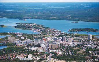
Northern Road Safety                         Other RV Water-fill
                                             and Pump-out Stations
Many highways are paved and
gravel roads are well maintained.            • Hay River Visitor Information Centre
The NWT has one of Canada’s                  • Fort Simpson Visitor Information
largest regions of continuous                  Centre (9401-100th St., water-fill
permafrost, which is constantly                station only)
shifting and settling. This                  • Yellowknife Water-fill Station
sometimes creates dips and                     (on Old Airport Rd., near the corner
bumps in our roads. It is important            of Kam Lake Rd., across from the
to use caution and drive according             Multiplex Arena)
to road conditions.
Driving Tips
• There are significant distances
  between gas stations and other                         attention!
  services.
• Keep headlights on at all times.
• Red diamond marker highway                    Ferries and Ice Roads
  signs indicate a significant bump
                                                Some highways are intersected by rivers that
  on the road.                                  must be crossed by ferry in the summer and ice
• Minimize dust and flying stones               road in the winter. The territorial government
  by staying well behind the vehicle            operates a free ferry service during the months
  in front of you and reduce your               that the rivers are free of ice – roughly, from May
  speed when vehicles approaching.              to November. When rivers freeze, ice roads
• Watch for construction                        replace ferries.
  equipment.
• Carry a spare tire and first aid/             River road crossings are not possible during
                                                periods of ice break-up in the spring and freeze-
  emergency road kit.
                                                up in the fall. Please check crossing conditions
• Watch wildlife, especially bison on           and hours of operation in advance.
  Highways 3, 5 and 7.
                                                Additional Travel Info
Park RV Water-fill/Pump-out
Stations *Location provides pump-out only.      Distances on route entries correspond to markers
                                                posted every 2 km along the highways, and are
•   60th Parallel Territorial Park*             estimates only.
•   Blackstone Territorial Park*
•   Fort Providence Territorial Park*           Cell phone coverage in the NWT is limited
•   Fort Simpson Territorial Park*              to the area immediately surrounding major
•   Fred Henne Territorial Park                 communities.
•   Happy Valley Territorial Park               A detailed road map – the NWT Explorers’ Map
•   Hay River Territorial Park                  can be obtained at visitor information centres
•   Lady Evelyn Territorial Park*               or from NWT Tourism or Tourism and Parks,
•   Little Buffalo River Crossing               Government of the Northwest Territories.
    Territorial Park*
•   Prelude Lake Territorial Park*              Telephone: 1 (800) 661-0788
                                                Email: info@spectacularnwt.com
•   Reid Lake Territorial Park*
•   Sambaa Deh Territorial Park*                For updated information on
•   Twin Falls Territorial Park*                NWT Ferries and Highways:
•   Queen Elizabeth Territorial Park            www.inf.gov.nt.ca or 1-800-661-0750
WATERFALLS ROUTE                     The following territorial
                                                                     campgrounds are located on
                                (Highway 1)                          this route: the 60th Parallel, Twin
                                When crossing the 60th parallel      Falls Gorge, Lady Evelyn Falls and
waterfalls route

                                from Alberta into the NWT,           Sambaa Deh Falls.
                                Alberta Highway 35 becomes
                                NWT Highway 1 and the                Interesting communities to visit
                                beginning of the Waterfalls Route.   along this route are Enterprise,
                                This route extends from the          Kakisa and Jean Marie River.
                                Alberta/NWT border to Enterprise     This route is also known as the
                                then continues to Checkpoint at      Mackenzie Highway, where you
                                the junction of Highways 1 and 7.    will see signs that display the
                                This route features numerous         symbols of a knife and quill. The
                                waterfalls, ranging from small       knife represents our Indigenous
                                and charming to large and            and trapping heritage. The quill
                                spectacular, as well as numerous     symbolizes our history and its first
                                rivers and lakes.                    recording by the famous explorer
                                                                     Sir Alexander Mackenzie, who
                                Territorial campgrounds              visited our area over 200 years
                                along this route are located         ago. The Mackenzie Highway was
                                in wilderness settings. Each         built in 1942 and is named in his
                                campground has unique natural        honour.
                                features and many offer excellent
                                hiking trails, sandy beaches,        Kilometres/Miles reflect distance
                                thundering waterfalls and great      from the NWT/Alberta border.
                                fishing spots.
                      G. SIGL
    www.NWTParks.ca

    4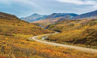
The 60th Parallel Visitor                     W1
Information Centre                            60th Parallel
Kilometre 0 (Mile 0)                          Territorial Park

                                                                                                                  waterfalls route
Upon entering the NWT from                    Kilometre 0 (Mile 0)
Alberta, the 60th Parallel visitor
staff will welcome you. The
Visitor Information Centre is
open from mid-May to mid-
                                              Adjacent to the 60th Parallel
September, with free coffee,
                                              Visitor Information Centre,
brochures, maps, fishing licences,
                                              this park has 9 non-powered
camping permits, pay phone,
                                              campsites nestled amongst birch
drinking water and washrooms.
                                              and aspen trees, and a scenic
Indigenous arts and crafts are
                                              picnic area overlooking the
on display and audio-visual
                                              beautiful Hay River.
presentations depict the northern
way of life. Make sure to ask for             W2
your “North of 60” Certificate to
commemorate your journey past
                                              Twin Falls Gorge
the 60th Parallel.                            Territorial Park
                                              Kilometre 72 (Mile 44.7)
                                              This beautiful park includes
      check it out!
                                              Alexandra Falls, Louise Falls and
                                              Escarpment Creek.
  • Look for the historic marker that         ) ATTENTION: There are many natural hazards
    commemorates the completion of the        within the Twin Falls Gorge Territorial Park (unstable
    Great Slave Lake Railway.                 cliffs, uneven surfaces, dangerous currents, slippery
  • Take a photograph of the NWT 60th         surfaces). Please exercise caution while enjoying this
    Parallel sign to share your experience.   Territorial Park.
  • View the breathtaking Alexandra and
    Louise Falls from lookouts.
  • Climb the awesome spiral staircase at
    Louise Falls.
  • Stroll the beautiful 2 km/
                                                                                                       C. FIELD

    1.2 mile trail that winds along the Hay
    River Gorge from Alexandra Falls to
    Louise Falls.
  • Learn more about the area from the
    drum shaped interpretive panels.
                                                                                                                       www.NWTParks.ca

                                                                                                                       5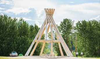
W2

                                                                                                                  B. STRAKER
                      Twin Falls Gorge
                      Territorial Park –
waterfalls route

                      Alexandra Falls Day
                      Use Area
                      Kilometre 72 (Mile 44.7)
                                                                          W2
                                                                          Twin Falls Gorge
                      A dramatically beautiful spot to                    Territorial Park –
                      enjoy a picnic, stroll the boardwalk
                      to Louise Falls or watch Alexandra                  Escarpment Creek
                      Falls tumble 32 metres over the                     Group Camping Area
                      Hay River. View the magnificent                     Kilometre 77.5 (Mile 48.2)
                      falls from either of two viewing
                      platforms a short walk away.
                                                             B. STRAKER

                                                                          There are 12 powered campsites
                                                                          well equipped for group camping
                                                                          as well as space for day use
                                                                          activities. An attractive series of
                                                                          small waterfalls adorn this deep
                                                                          gorge of the Hay River.
                      W2                                                  Enterprise
                      Twin Falls Gorge                                    Kilometre 83.2 (Mile 51.7)
                      Territorial Park –
                      Louise Falls Campground                             Enterprise is the premier
                      Kilometre 74.6 (Mile 46.4)                          community after the 60th
                                                                          Parallel. Located at the junction
                                                                          of Highways 1 and 2, the small
                                                                          hamlet has a population of 102
                      Louise Falls offers 28 powered                      residents. For your convenience
                      campsites surrounded by jack                        there is a gas station just off Hwy 1
                      pines, spectacular flora and                        and if you would like information,
                      400 million year old limestone                      the friendly staff at the local
                      formations along the Hay River                      Hamlet office (on Robin Rd.) are
                      gorge. A unique 138-step spiral                     always happy to welcome you.
                      staircase leads you down the
                      embankment to a viewpoint                           Junction of Highways 1 & 2
                      overlooking the three-tiered                           Kilometre 83.2 (Mile 51.7)
                      Louise Falls. Please note,                          Keep left on Highway 1 to
    www.NWTParks.ca

                      drinking water is provided, but                     continue the Waterfalls Route.
                      the closest RV water-fill station                   Highway 2, to the right, leads to
                      from Louise Falls Campgrounds                       Hay River and Fort Resolution
                      is located at the Hay River Visitor                 (Great Slave Route) and to Fort
                      Information Centre.                                 Smith (Wood Buffalo Route).

   6
W3                                    warm boulder-strewn river with
McNallie Creek Territorial            many lovely spots for wading
                                      and swimming. The fishing is
Park Day Use Area                     excellent! Northern pike, pickerel/

                                                                                       waterfalls route
Kilometre 119.8 (Mile 74.4)
                                      walleye and Arctic grayling can
                                      often be hooked by casting with
                                      small spoons into the pools at the
A small picnic area with a short      base of the falls.
trail leading to the 17-metre
McNallie Creek Falls. At the

                                                                            C. FIELD
viewing platform, a plaque
explains the origin of the creek’s
name. Look for the cliff swallows
nesting in the ravine walls.

Slave River
Lowlands Overview                     Kakisa
Kilometre 123 (Mile 74.4)             Kilometre 168.5 km (Mile 104.7)

From here you can see the Slave       To reach this small Dene
River lowlands as they roll north     community (pop. 40), follow the
and west to the shores of Great       access road off Highway 1 and
Slave Lake. You can also see the      travel another 5 km/3 miles past
only high-rise building in Hay        the Lady Evelyn Falls campsite
River, which is over 50 km/31.7       road. This picturesque log village
miles away.                           has a convenience store, with
                                      groceries, gasoline and a motel.
W4
Lady Evelyn Falls                     W5
Territorial Park                      Kakisa River Territorial
Kilometre 167.1 (Mile 103.8)          Park Day Use Area
                                      Kilometre 168.8 (Mile 105.1)

Take the access road to the south     Take a break to enjoy a picnic
off Highway 1 for 6.8 km/4.2          or spend the afternoon fishing
miles to the park. This park has      (in season) along the fast-moving
23 powered campsites and Lady         Kakisa River. Watch for trophy
Evelyn Falls are only a short         grayling. Great Slave Lake is
walk away. These dramatic falls       home to the current world record
form a giant curtain of water         Arctic grayling and one of the
as the Kakisa River spills over a     grayling’s favourite spawning
                                                                                            www.NWTParks.ca

limestone escarpment. A staircase     tributaries of Great Slave Lake is
leads into the gorge at the base      the Kakisa River. Hike the trail to
of the falls. The Kakisa River is a   Lady Evelyn Falls.

                                                                                            7
Junction of Highways 1 & 3             W6
                         Kilometre 187.5 (Mile 116.5)        Sambaa Deh Falls
                      Continue west on Highway 1 to          Territorial Park
                      complete the last portion of the
waterfalls route

                                                             Kilometre 325 (Mile 245)
                      Waterfalls Route. Highway 3 is
                      the beginning of the Frontier Trail,
                      which ends in Yellowknife.

                      Bouvier Creek                          The park has 20 non-powered
                      Kilometre 277.4 (Mile 172.5)           campsites. It is located at the
                      In springtime, this creek offers a     junction of Highway 1 and the
                      nice fishing experience, a great       Trout River. The Trout River
                      scenic point and a good place to       (Sambaa Deh in the Slavey
                      look for fossils!                      language) was traditionally an
                                                             important transportation route for
                      Wallace Creek                          the Indigenous populations of the
                      Kilometre 289.4 (Mile 179.6)           area (before and during the fur
                                                             trade). The falls forced travellers
                      A pretty rest spot that offers
                                                             to portage around this dangerous
                      a short 15 minute forest walk
                                                             stretch of water. Hiking trails take
                      north to a small, but sometimes
                                                             you to views of both Sambaa
                      spectacular, waterfall.
                                                             Deh and Coral Falls, with a new
                      Redknife River                         viewing platform that overlooks
                      Kilometre 295.2 (Mile 183.8)           the gorge. Coral Falls is so named
                                                             due to the numerous coral fossils
                      A favourite fishing spot for
                                                             washed down the river each year.
                      pickerel/walleye or Arctic
                      grayling.

                      Sambaa K’e                                    check it out!
                      Kilometre 321.3 (Mile 200.1)

                                                                This park has three impressive
                      Looking south, you may see                geographic features:
                      evidence of the winter road               • Sambaa Deh Falls, which are readily
                      that leads 126 km/78 miles to                visible from the bridge that crosses
                      the Dene community of Sambaa                 Trout River.
                      K’e (pop. 85). There is no road           • Coral Falls, which are approximately
                      access to the community in the               1.5 km/1 mile upstream.
                      summer, but air charters are              • The dramatic gorge running along the
                      available from Fort Simpson and              north side of the highway about 0.5 km
                      Hay River. The community is                  west of the bridge.
                      known for its traditional lifestyles      • Good fishing for Arctic grayling and
                      and big fish. The community-run
    www.NWTParks.ca

                                                                   pickerel/walleye.
                      Sambaa K’e Fishing Lodge offers
                                                                • Fossils can be found throughout
                      a rustic fishing experience,
                                                                   this area.
                      with the opportunity to catch
                      lake trout, pickerel/walleye and
                      northern pike.

    8
Jean Marie River Checkpoint
Kilometre 375 (Mile 233) Kilometre 413 (Mile 258)
NO VISITOR SERVICES here.
waterfalls route
An access road north of Highway Junction of Highways 1 & 7
1 leads 27 km/17 miles to the Continue northwest on
community of Jean Marie River Highway 1 to travel the Heritage
(pop. 71). There is a small Route to Fort Simpson and
community campground here. Wrigley. Highway 7, the Liard Trail,
To book a campsite, contact leads south to Fort Liard and the
(867) 809-2000. The community Alaska Highway.
boasts a number of fine artisans,
) ATTENTION: The nearest location for fuel is
some of whom have great skill
in the creation of beautiful crafts Fort Simpson (61 km/38 miles). If you are taking the
using moose hair tufting. Liard Trail, the next available fuel is at Fort Liard
(223 km/138 miles).
Jean Marie River Bridge
Kilometre 412 (Mile 256) Checkpoint
In spring, the fishing is good here Bed and Breakfast
and paddlers use this location Kilometre 413 (Mile 258)
as a starting point to reach Fort Beautifully located next to the
Simpson via the Jean Marie and Jean Marie River Bridge, they also
Mackenzie Rivers. have spots for RVs and tents, as
well as easy fishing access along
) ATTENTION: As water levels drop, Jean Marie Jean Marie River in the spring.
River may become impassable. Visit Environment (867) 695-2953.
Canada’s hydrometric portal for real-time water level chkpoint@hughes.net.
updates for rivers across the north:
https://wateroffice.ec.gc.ca/
B. WEILAND
www.NWTParks.ca
9HERITAGE ROUTE Junction of Highway 1
(Highway 1) and Fort Simpson Access
Kilometre 471.3 (Mile 292.9)
This route extends from
hErITaGE route
Checkpoint northwest to Fort Highway 1 turns left to take you
Simpson and then on to Wrigley. northwest to the community of
You will travel through a beautiful Wrigley. Continuing straight will
region of forested hills, mountains, take you to the main portion of
and clear lakes and rivers. Outdoor the village of Fort Simpson.
activities are within easy reach -
camping, fishing, hiking, canoeing, Fort Simpson
rafting and viewing nature. Kilometre 471.3 (Mile 292.9)
A community campground is also
available in Wrigley.
Kilometres/miles reflect distance Fort Simpson (pop. 1,209) is
from the NWT/Alberta border. located at the confluence of the
Mackenzie and Liard Rivers, and
The Lafferty Ferry – is the largest community in this
Liard River Crossing region and the oldest former
Kilometre 456.4 (Mile 283.6) trading post on the Mackenzie
River. It is the primary location
This ferry operates daily from from which to access the
8:00 a.m. until 11:45 p.m. “on Nahanni National Park Reserve
demand” from late May through and Nááts’ihch’oh National Park
October. In winter, an ice road Reserve of Canada, where the
replaces the ferry. park has its main office.
) ATTENTION: Crossing the river is not possible
during spring ice break-up and fall river freeze-up.
To check current river crossing conditions:
www.inf.gov.nt.ca or 1-800-661-0750
B. WEILAND
B. WEILAND
www.NWTParks.ca
10) ATTENTION: Access to Nahanni National Park Company (subsequently the
Reserve and Nááts’ihch’oh National Park Reserve is Hudson’s Bay Company). The
primarily through air charters, which can be arranged “Fort of the Forks” was established
from several communities in the NWT, including Fort and was later renamed Fort
hErITaGE route
Simpson, Fort Liard and Yellowknife. Visit the National Simpson after the first governor of
Park office for more information or the Hudson’s Bay Company.
http://www.pc.gc.ca.
The Mackenzie River was named
B. WEILAND
after Alexander Mackenzie, who
was an explorer seeking a route
west to expand the fur trade. As it
turned out, the Mackenzie River
took him north rather than west
and opened up a different world
to the traders.
Fort Simpson has a nine-hole
golf course, a 32-site territorial check it out!
campground and a very nice
Visitor Information Centre, with a
wealth of displays and historical • Fort Simpson’s Papal Site is now home
information. Local arts and crafts to the largest wooden teepee in the
shops feature traditional Dene world, at 50 ft tall.
artwork.
• Ask about an Historical Walking Tour at
Historically, this area was a the Visitor Information Centre.
primary meeting place for First • “Open Sky Festival” is an annual arts/
Nations prior to contact with music festival generally held the first
European-based traders, explorers weekend in July.
and settlers. During the fur trading • Arrange an air charter to Nahanni
years, this area was an important National Park.
location for the Northwest Trading
• A great location for bird-watching
and listening to a frog’s chorus! Many
different species of birds have been
documented in this area and many
use the “Snye” as a nesting area. The
Snye is a shallow wetland ecosystem
B. WEILAND
located between the main portion of the
community and the southern shoreline
of the river. Many species of migratory
waterfowl may be seen in season,
including tundra swans and snow geese.
www.NWTParks.ca
11H1 Martin River
Fort Simpson Kilometre 489.9 (Mile 304.4)
Territorial Park The one-lane bridge at this
hErITaGE route
Kilometre 474 (Mile 294.5) location should be taken with
great care and reduced speed.
Local people often fish here
when the pickerel/walleye or
Located at the entrance to Fort Arctic grayling are active.
Simpson, and at the confluence
of the Mackenzie and Liard Shale Creek
Rivers, this park has 21 powered Kilometre 529.5 (Mile 329)
sites, and 11 non-powered sites. This small creek contains a one-
Services and attractions in the lane bridge crossing that requires
town are within walking distance, caution and reduced speed.
including the Papal Site, where
Saint John Paul visited in 1987. The Johnny Berens Ferry
– Nduleh Crossing
Junction of Highway 1 Kilometre 550.5 (Mile 342.1)
and Fort Simpson access The ferry operates “on demand”
Kilometre 471.3 (Mile 292.9)
from 9 a.m. to 11 a.m. and from
To complete the Heritage Route, 2 p.m. to 8 p.m. from late May
head northwest 220.5 km/137 through October.
miles to Wrigley.
) ATTENTION: This river crossing is subject to
Kilometres/miles reflect the extreme high and low water level fluctuations, which
distance from NWT/Alberta may cause delays. Crossing the river is not possible
border. during spring ice break-up and fall river freeze-up.
Check the current river crossing conditions:
www.inf.gov.nt.ca or 1-800-661-0750
did you know?
• Water is trucked into most of our
parks – please use wisely.
B. WEILAND
www.NWTParks.ca
12Willowlake River River Between
Kilometre 625 (Mile 388.4) Two Mountains
The Willowlake River winds its Kilometre 652.9 (Mile 405.7)
hErITaGE route
way from the Horn Plateau in the This river cuts a channel through
east to the Mackenzie River. This the McConnell Range in the east,
river was historically used by the on its way to the Mackenzie River.
Indigenous groups from the east The river has substantial cultural
to bring furs to Fort Alexander, and historical significance to the
which was located near here. First Nation groups in the area.
The furs and supplies were then
traded and goods transported to Wrigley
market via the Mackenzie River. Kilometre 690 (Mile 428.7)
Mackenzie Valley
Viewpoint Wrigley (pop. 153) is the
Kilometre 631 (Mile 392.2) northernmost all-season access
point along the Heritage Route/
Great view to the south of the
Highway 1. This picturesque
Mackenzie Valley and River,
community overlooks the
meeting with the Willowlake
Mackenzie River, with the Franklin
River. Looking west across the
Mountains in the distance. Most
Mackenzie River and several
of the Dene people in Wrigley live
large islands, you can see the
in log homes and carry on their
Mackenzie Mountains beyond.
traditional livelihoods of hunting,
Looking east you can see the
fishing and trapping. In the winter,
beginnings of the McConnell
the community provides a stop-
Mountain Range, which turns into
over for vehicles driving further
the Franklin Mountain Range a
north on the winter roads to the
little further north.
communities of Tulita, Deline,
Norman Wells, Fort Good Hope
and Colville Lake.
M. LYS
www.NWTParks.ca
13LIARD TRAIL ROUTE
B. WEILAND
(Highway 7)
This route starts at the NWT/
liard trail
British Columbia (BC) border and
takes you northeast, following the
scenic river valley through Fort
Liard to Checkpoint. It features Fort Liard
inspiring views of the Liard River Kilometre 37.6 (Mile 23.4)
and the Nahanni Mountains,
especially at Blackstone Territorial
Park, the only territorial park on
this route. This small community (pop. 615) is
Kilometres/miles reflect distance located 6.4 km/4 miles west of the
from the NWT/BC border. Liard Highway, at the confluence
of the Liard and Petitot Rivers. The
NWT/BC Border view of the rivers and mountains
Kilometre 0 (Mile 0) from the access road and the
community is well worth the short
Be sure to check out the side trip.
welcome signs!
Fort Liard is considered “the
tropics of the north” as it often
check it out! has the warmest weather and
best growing conditions in the
Northwest Territories. This is one
• Home of Acho Dene, renowned for their of the oldest continuously settled
birch bark and porcupine quill artistry. areas in the north.
• Visit the Visitor Information Centre and
arts and craft store, which includes 15
flavours of ice cream!
B. WEILAND
www.NWTParks.ca
14Muskeg River Netla River
Kilometre 46.6 (Mile 29) Kilometre 115.9 (Mile 72.0)
You will find a turnout with This area provides an important
liard trail
interpretive signage at north waterfowl breeding habitat. Great
end. This is a good fishing spot views of the mountains on the
for pike, pickerel/walleye and opposite side of the Liard River.
freshwater clams. Frequently, this
area is used as a swimming hole Nahanni Butte
by local residents. Kilometre 138.9 (Mile 86.3)
Hay Lakes Municipal
Campground Looking west you will see the
Kilometre 47 (Mile 29) location of the winter ice road
that leads 22.3 km/13.8 miles to
This municipal campground is Nahanni Butte (pop. 92). This
located about 4 km/2.5 miles small Dene community, at the
along the access road to Fort confluence of the South Nahanni
Liard. Situated next to a small and Liard Rivers, is accessible in
lake, it has a kitchen shelter and summer by boat, floatplane or
several campsites. wheeled plane. Contact Nahanni
Butte Dene Band to arrange a boat
Liard Valley Viewpoint taxi (867) 602-2900.
Kilometre 77 (Mile 47.8)
G. FRICKE
This rest stop provides a
picturesque view of the Liard
Valley and the mountains in the
Liard Range.
Nahanni National
Park Reserve
Nahanni National Park Reserve,
protects a portion of the Mackenzie
Mountains Natural Region. The
centerpiece of the Park is the South
Nahanni River. Four noteworthy
canyons, reaching 1,000 metres
in depth, line this spectacular river.
At Virginia Falls, the river drops an
incredible 90 metres, nearly double
the vertical drop of Niagara Falls.
The South Nahanni region offers
www.NWTParks.ca
spectacular hiking opportunities,
mostly by boat from the river
corridor. The majority of visitors
travel to the Park by chartered
float plane via Fort Simpson or
Yellowknife.
15LT1 Lindberg Landing
Blackstone River Kilometre 154 (Mile 95.7)
Day Use Area A road leads west to the small
liard trail
Kilometre 145.9 (Mile 90.7) homestead of Lindberg Landing
on the shore of the Liard River.
This location has for many years
There is a small picnic area been used as a landing site for
between the two bridges. travellers on the South Nahanni
and Liard Rivers. Rustic cabins
LT2 and guest houses are available.
Blackstone Reservations are requested.
Territorial Park Please email: lindberglanding@
Kilometre 150.3 (Mile 93.4) hotmail.ca.
L. ADAMSON
This park has 19 non-powered
campsites in a spectacular setting
rich in historical significance, alive
with abundant wildlife and framed
by stunning mountain views. The Poplar River
fast flowing Liard River, and its Kilometre 219.7 (Mile 136.5)
proximity to the South Nahanni
Good Arctic grayling and
and Blackstone Rivers, makes this
pike fishing.
an excellent start or end point for
canoeists, boaters or anglers. The
visitor information building, built
with local logs, is open from mid-
May to the end of September.
S. HARDISTY
www.NWTParks.ca
16GREAT SLAVE ROUTE Paradise Gardens
(Highways 2, 5 and 6) Kilometre 14 (Mile 8)
This is the largest market gardening
At Enterprise, take Highway 2
great slave route
area in the NWT. Here, rich soil has
to begin the Great Slave Route.
built up along the banks of the Hay
This interesting drive takes you
River and long summer days make
to two communities located
for good wheat, vegetable and
along the southern shores of
raspberry growing.
Great Slave Lake - Hay River and
Fort Resolution. There are two Hay River Golf Course
campgrounds located along this Kilometre 25.3 (Mile 15.7)
route: Hay River Territorial Park
and Little Buffalo River Crossing A scenic nine-hole golf course, with
Territorial Park. artificial greens, sprawled along the
Hay River. The clubhouse serves
Kilometres/miles reflect distance meals and drinks. Licensed facility.
from Enterprise. Visitors are welcome.
Hay River
check it out! Kilometre 38 (Mile 23.6)
• Hay River is the largest shipping centre
in the north.
Located on Great Slave Lake, the
• The town has the look and feel of a
community of Hay River (pop.
seaport, with its tugs, barges and
3,728) began as a mission and
commercial fishing operations.
fur trade centre in 1858. Water,
• Get your fishing license and experience road and rail transportation links
some great fishing. have made Hay River “the hub of
• Opportunity to visit several arts and the north”. The Great Slave Lake
crafts shops. Railway ends here. Mackenzie
• Visit the Fisherman’s Wharf, every River and Arctic Coast freight
Saturday from 10 a.m. to 2 p.m. during barging begins where the Hay
the summer. River meets Great Slave Lake.
C. FIELD
www.NWTParks.ca
17GS1 will bring you to the small Dene
Hay River Territorial Park village of Kátł’odeeche First Nation/
Kilometre 46 (Mile 28.6) Hay River Dene Reserve. The village
is home to the unique Yamozha
great slave route
K’ue Society (Dene Cultural
Institute), which has a small craft
shop (Open M-F
Located on Vale Island right in the 1-4 pm). There is also a small
community of Hay River (follow grocery store and gas station
signs, it’s about 10 km/6 miles located further along the main
past the information centre), the community road.
campground has 43 powered
campsites, with nearby wilderness A few kms north of the main village
and modern amenities. Group (keep right on the main road)
camping sites are available. This you will arrive at the Hay River
park offers fantastic swimming on Mission Sites National Historic Site
the sandy shores of Great Slave of Canada. Established in the late
Lake, unique viewing of barges 19th century, the site consists of
and fishing vessels plying the St. Peter’s Anglican Church, Ste.
waters, and great opportunities to Anne’s Roman Catholic Church,
fish for northern pike. Campsite informational panels, the remains
A3 at Hay River Territorial Park has of a rectory, and associated
been designated as wheelchair cemeteries containing spirit houses.
accessible. To book, contact the
Park Manager directly. Contact For more information about the
information is at www.nwtparks. Hay River Mission Sites National
ca/contact-us. Historic Site of Canada, visit: http://
historicplaces.ca/en/rep-reg/place-
Junction of Highways 2 & 5 lieu.aspx?id=12080
Kilometre 32.0 (Mile 19.9)
When leaving Hay River, turn
east onto Highway 5 to reach check it out!
Fort Resolution and Fort Smith.
Continue south on Highway 2 to
return to Enterprise. Great Slave Lake is:
• A remnant of an enormous inland sea
) ATTENTION: There are no services between scoured out of the Canadian Shield by
Hay River and Fort Resolution (156 km/96.9 miles) or glaciers during the last Ice Age.
Fort Smith (268 km/167 miles). • The second largest lake wholly
within Canada, with an area of 28,438
The Hay River Dene km2/10,980 miles2.
Reserve/Kátł’odeeche • The deepest lake in North America at 616
First Nation metres/2,027 feet deep.
www.NWTParks.ca
Kilometre 34.3 (Mile 21.3)
Eastbound on Highway 5, turn
left immediately after the Hay
River Bridge. A 5 km drive north
18Junction of Highways 5 & Fort Resolution
6 (Buffalo Junction) Kilometre 90 (Mile 55.9)
Kilometre 61 (Mile 37.9)
great slave route
Continue east on Highway 6 to
Fort Resolution to complete the
First located at the mouth of the
last portion of the Great Slave
Slave River, Fort Resolution (pop.
Route. Highway 5 to the south
499) was moved to its present
is the start of the Wood Buffalo
location in 1796. The first settlers
Route, which ends in Fort Smith.
were Cree-Metis. By 1852, Oblate
Kilometres/miles reflect distance priests had arrived to establish a
from junction of Highway 5 and 6. mission and school. Treaty 8,
with the Chipewyan, was signed
GS2 here in 1900. Fort Resolution was
Little Buffalo River a major medical and educational
Crossing Territorial Park centre until the 1950s. For a
Kilometre 67.3 (Mile 41.8) taste of northern history and
insight into the Dene way of life,
Fort Resolution is an excellent
Here you will find 20 powered destination.
sites on the shores of Little
Buffalo River and minutes away
check it out!
from Great Slave Lake. A pleasant
stopping point for fishing, boating
and picnicking, or as a base to
• Fort Resolution is the oldest,
explore nearby Fort Resolution.
continuously occupied modern
settlement in the NWT.
• Information on walking tours of the
town and boat trips to the original
settlement are available at the
Community Council Office.
A. HOUWELLING
www.NWTParks.ca
19WOOD BUFFALO
J. JAQUE
ROUTE
(Highway 5)
wood buffalo route
The Wood Buffalo Route takes you
to the community of Fort Smith
(pop. 2,451) and Wood Buffalo
National Park, the largest National
Wood Buffalo
Park in North America. National Park
Kilometre 97.6 (Mile 61.0)
The Wood Buffalo Route is now
A UNESCO World Heritage Site,
paved all the way to Fort Smith.
this 44,800 km2/17,300 mi2 park is
Of special interest along this route the largest national park in North
are the golf course in Fort Smith, America. Established in 1922,
the salt plains and bison in Wood the park protects one of the last
Buffalo National Park, white water remaining free-roaming herds of
rafting and kayaking on the Slave wood bison (approximately 3,500)
River, and pelicans at the Slave in the world. There are other park
River rapids! attractions, including the last
remaining natural nesting ground
There are two campgrounds on of the endangered Whooping
this route: Little Buffalo River Falls Crane, the biologically rich Peace-
and Queen Elizabeth Territorial Athabasca River Delta, extensive
Park, near Fort Smith. salt plains that are unique in
Canada, and some of the finest
Kilometres/miles reflect distance
examples of gypsum karst
from the junction of Highway 2
topography in North America.
and 5.
Stop at the Wood Buffalo Visitor
Junction of highways, 5 & 6 Information Centre in Fort Smith
to learn more about the park
(Buffalo Junction) through interpretive displays.
Kilometre 61.0 (Mile 36)
J.F. BERGERON
www.NWTParks.ca
20Angus Fire Tower WB1
Kilometre 107 (Mile 66.9) Little Buffalo River Falls
Territorial Park
wood buffalo route
Angus Tower features a giant Kilometre 214.6 (Mile 133.6)
sinkhole, evidence of the unique
karst topography of this area.
Here you will find six non-
powered sites in a uniquely
Nyarling River Pull Off
picturesque spot. The area was
Kilometre 120.8 (Mile 75.0)
devastated by a forest fire in
This pull off features interpretive 1981, but re-growth has been
displays describing the unique swift. Now, the area is an ideal
geology of the Nyarling River and spot to observe and learn how
where the river begins travelling nature revives and replenishes the
underground. land. Relax by a small waterfall
or launch your canoe in the
Wetlands Pull Off gorge below. Camping permits
Kilometre 201.4 (Mile 125.9) are available at the on-site
Follow a short interpretive self-registration kiosk. Sites are
trail down to a peaceful area available on a first-come, first-
overlooking habitat similar to served basis.
that of the whooping crane
nesting area. Salt Plains
Overlook Access
Wood Buffalo National Kilometre 230 (Mile 143.8)
Park Boundary A 13 km/8 mile road takes you
Kilometre 212.2 (Mile 132.6) to an amazing panoramic view
of the salt plains. For a close-up
view, take the hiking trail down.
There is an interpretive exhibit,
a viewing telescope, picnic area
and outhouses.
D. ROBERTS
www.NWTParks.ca
21WB2 There are several recreation
Queen Elizabeth facilities, including a golf course,
a swimming pool, tennis courts
Territorial Park and a recreation complex. The
wood buffalo route
Kilometre 261.0 (Mile 162.2) Fort Smith Visitor Reception
Centre is located at Wood Buffalo
National Park, headquarters at
149 McDougal Road.
Located just outside of the
H. EDEN
community of Fort Smith, this
park has 24 powered campsites
and a number of nearby
attractions. There are trails
around the park and to great
views of the Slave River, whose
rapids are a world-class venue
for white water kayaking and WB3
rafting. Keep your eyes peeled Fort Smith Mission
for summer colonies of white Territorial Park
pelicans in their northernmost Day Use Area
outpost in the world.
Fort Smith Visitor Centre Fort Smith Mission Heritage Park
and Wood Buffalo is all that remains of the original
National Park Office 151 acre Oblate Catholic Mission
Kilometre 264 (Mile 165) Church, in what is now the center
of the town. The park provides an
Fort Smith extensive self-guided tour of the
Kilometre 266 (Mile 165.3) site, with sign boards describing
various aspects of the history and
activities of the mission.
Fort Smith (pop. 2,451) was
once the political capital of the check it out!
Northwest Territories. On the
NWT/Alberta border, it is the
southernmost community in the • The Northern Life Museum has extensive
NWT and is now known as “The galleries depicting the traditional
Garden Capital of the North”. lifestyle and activities of First Nations
Situated on the shore of the Slave and Metis people.
River, on the original portage route • The Slave River’s four major rapids –
around the Slave River Rapids, the Cassette, Pelican, Mountain and Rapids
town began as a fur trading post of the Drowned – produce some of the
www.NWTParks.ca
(Hudson’s Bay Company) in 1874, biggest and best whitewater in the
but fur traders travelling down the world.
Mackenzie River had been using
the area as a stopover for more
than a century.
22FRONTIER TRAIL F1
ROUTE Dory Point Territorial Park
(Highway 3) Day Use Area
frontier trail
Kilometre 21.2 (Mile 13.2)
Driving north on Highway 3, the
Frontier Trail will take you through
rolling, polished Precambrian rock, Located a short way from the
dotted with thousands of clear Deh Cho Bridge, on the south
lakes and rivers. bank of the mighty Mackenzie
River, which is flowing out of
The Frontier Trail Route is paved Great Slave Lake.
all the way to Yellowknife.
The Deh Cho Bridge –
Interesting communities
to visit along this route are Mackenzie River Crossing
Fort Providence, Behchokò ˛, Kilometre 23.6 (Mile 14.7)
N’Dilo, Dettah and Yellowknife. Officially opened on November
Yellowknife, the capital of the 30, 2012, this 1.045 km/0.65 mile
Northwest Territories, is located bridge crosses the Mackenzie
on the north shore of Great Slave River near the community of Fort
Lake and offers all the amenities of Providence. The Deh Cho Bridge
a southern city. provides visitors and northern
residents travelling this stretch of
Territorial campgrounds along
highway with a safe, reliable all-
this route are located at Fort
weather road. Previously, this road
Providence and at Fred Henne
was crossed by a ferry or an ice
Park in Yellowknife.
road during freeze up.
Kilometres/miles reflect distance
from junction of Highways 1 and 3.
check it out!
) ATTENTION: Watch for bison on and beside
the highway along this route. Drive with caution.
• A gas station, restaurant and an arts
and crafts store is located a few minutes
after crossing the Deh Cho Bridge, just
before the turn off to Fort Providence.
• Authentic Tłı˛cho˛ art can be purchased
C. FIELD
in Behchokò˛ at the community’s newly
renovated craft store located in the
Khon Go Cho Complex, or visit
https://onlinestore.tlicho.ca/
www.NWTParks.ca
23C. FIELD
C. FIELD

C. FIELD

           C. FIELD
J.F. BERGERON
C. MYERS
C. MYERS
frontier trail
The Mackenzie Bison Fort Providence
Sanctuary Kilometre 36.4 (Mile 22.6)
Kilometre 25.6 (Mile 15.9)
For the next 80 km/50 miles or
so, the area of land from the
highway east to Great Slave Lake This community is 5 km/3 miles
is set aside for free-roaming wood down an access road west of
bison. The bison often roam on Highway 3. Fort Providence
and around the highway. Keep a (pop. 797) is a scenic and historic
lookout and use caution if bison community located on the banks
are on the road. A collision with of the Mackenzie River. A Roman
an animal can be fatal to both Catholic Mission was established
parties. Treat these animals with in 1861 and Our Lady of Fort
respect. They may look slow Providence church is a major
and docile, but can move with landmark. An excellent craft shop
amazing speed and aggression. features moose hair tufting, a
Keep your distance. local specialty.
) ATTENTION: There are no services along
F2 Highway 3 for another 224 km/139 miles, so if you are
Fort Providence going to Yellowknife, gas up!
Territorial Park
Kilometre 33.4 (Mile 20.7)
check it out!
There are 33 powered campsites, • Long history as a trading post and a
a group campsite with 10 mission to the Dene people.
powered stalls, and 11 non- • Mission priests once farmed extensively
powered day use sites situated on in this area.
the north bank of the Mackenzie • West of town are two historical cairns:
River, only a 2 km/1.2 miles drive one commemorating Sir Alexander
off Highway 3. Enjoy spectacular Mackenzie’s 1789 voyage, the other
sunsets, great fishing and bird acknowledging the contribution of the
watching, and the amenities and Grey Nuns to the community.
attractions of nearby historic Fort
www.NWTParks.ca
Providence.
26fishing, but fishing is closed May 1
KIEWIT
to June 30 for conservation.
F4
frontier trail
North Arm Park
) NEW CAMPGROUND COMING SOON!
Kilometre 232 (Mile 144.2)
Access to Whatì
Kilometre 97 (Mile 60.27)
The newly completed Tłı˛cho˛ Stop here for a great view of
Highway, provides all season Great Slave Lake. Be sure to look
access to Whatì. around you – the scenery abruptly
changes from the rocky Canadian
F3 Shield to Mackenzie Lowlands
Chan Lake Territorial Park and is a haven for waterfowl.
Campground Coming Soon! Visit
Day Use Area our website for details.
Kilometre 123.8 (Mile 77)
Access to Behchokò
˛
Kilometre 239 (Mile 148.5)
A picturesque spot for a picnic,
located at the northern end of Turn off to the community of
the Mackenzie Bison Sanctuary. Behchokò ˛. No services here.
Wildlife abounds: Watch for bison
on the road, sandhill cranes in the Behchokò
˛
vegetation on the road side and Kilometre 245 (Mile 152.2)
waterfowl on Chan Lake.
Mosquito Creek
Kilometre 227.3 (Mile 141.2) The main community of Behchokò ˛
No visitor facilities, but a turn off (pop. 2,154) is 11 km/7 miles west
leads to a trail going down the of Highway 3. The community of
creek. Good pickerel/walleye Behchokò ˛ is the headquarters of
the Tlicho Region and the largest
Dene community in the NWT.
Behchokò ˛ hosts some large Dene
cultural events throughout the year
D. BROSHA
and is located on a river system
that links the Great Slave Lake and
Great Bear Lake. The community
features some unique modern
architecture that takes design cues
from the traditional caribou hide
lodge or teepee. There is a gas bar,
www.NWTParks.ca
restaurant, convenience store, bed
and breakfast, and a craft store with
local art available for purchase.
27Yellowknife Golf Club F5
Kilometre 334 (Mile 207.5) Fred Henne Territorial
Yellowknife Golf Club is just off Park Day Use Area
frontier trail
the highway to the north and is Kilometre 336 (Mile 208.8)
an 18-hole golf course, with sand
fairways, artificial greens, pro shop
and licensed clubhouse. It is home A roadside turn-out to the north
to the famous June 21 Midnight provides access to this popular
Sun Golf Tournament.Continuing recreational area on the shores
along the highway to Yellowknife, of Long Lake. Here you will
after passing a sandy area on find picnic sites, a boat launch,
the right, you will notice several kitchen shelters, a sandy beach, a
buildings at the end of the airport playground and change houses.
runway. These are diamond Being one of the smaller lakes,
sorting plants. To the left is the Long Lake warms up enough in
Folk on the Rocks site, a popular the summer to make it a favourite
summer music festival usually place for water activities, including
held the third weekend in July. swimming, boating, tubing, water
skiing, windsailing and jet skiing.
Yellowknife Airport
Kilometre 335.6 (Mile 208.5) Junction of Highway 3 &
The Yellowknife Airport is situated Old Airport Road
on the right side of the road Kilometre 336.7 (Mile 209.2)
across from Long Lake. Turn right onto Old Airport Road
to reach Yellowknife via the
commercial area. Continue left
check it out! on Highway 3 a short distance
to reach Fred Henne Territorial
Park access on the left. Continue
• There is an excellent 4 km/ past the park to reach downtown
2.5 mile hiking trail that starts just to Yellowknife.
the left of the shower building. This
Prospectors’ Trail will take you around
several fascinating geological features.
B. WILSON
www.NWTParks.ca
28Yellowknife
B. WILSON
Kilometre 338.8 (Mile 210.5)
frontier trail
Yellowknife (pop. 20,960) is
a modern city, with shopping
F5 facilities and all the services you
Fred Henne would expect to find in larger
Territorial Park southern communities.
Kilometre 337 (Mile 209.4)
Located on the shores of the
beautiful Great Slave Lake,
Yellowknife is an unusual
blend of many southern and
Something for everyone: Choose northern cultures. It is a city of
from 75 powered sites and 40 contrasts, with modern high-rise
non-powered sites (including 9 towers overlooking the rustic
tent pads). Swim off Long Lake’s heritage buildings of Old Town.
sandy beach, hike the 4 km/2.5 Yellowknife is a modern city that
mile Prospector’s Trail, camp, still acts like a small town and this
picnic, canoe, wakeboard or enjoy gives the city its unique flavour.
the amenities and attractions of
Yellowknife, located just 3 km/1.8 There is easy access to fishing,
mile away. This park provides urban canoeing, hiking, camping,
convenience in a wilderness setting. golfing and nature viewing.
Annual summer events include
Junction of Highways 3 & 4 an arts festival, folk music festival
Kilometre 337.3 (Mile 209.6) and golf tournaments. The
Continue on Highway 3 to reach city also features many parks
Yellowknife, turn left to visit and playgrounds, a racquet
territorial parks on the Ingraham club, curling rink, pool, movie
trail. theatre and golf course. Many
well-established outfitters
and interesting lodges are
headquartered or serviced out
of Yellowknife. Tour packages
T. SPENCER
for all tastes, including fishing,
sailing or canoeing, are easy to
arrange.
For a listing of tourism operators,
visit https://spectacularnwt.com/
directory/operators, and to learn
www.NWTParks.ca
more about Yellowknife festivals
and events, check out https://
extraordinaryyk.com/
29CITY OF YELLOWKNIFE
D. HORN
frontier trail
Thaidene Nëné
National Park Reserve check it out!
In 2019, Thaidene Nëné National
Park Reserve was established
as Canada’s 47th national park. • Visit the many cultural and historical
Located at the eastern end of displays at the Prince of Wales Northern
Great Slave Lake, the park is part Heritage Centre museum.
of a larger group of protected • Take an informative tour of the
areas around the East Arm and Legislative Assembly Building.
Artillery Lake regions. Thaidene • See a local play or an internationally
Nëné means ‘Land of the known singer at the Northern Arts and
Ancestors’ in the Dënesųłiné Cultural Centre.
– or Chipewyan – language.
• Visit nearby Indigenous communities of
The spectacular wilderness
Behchokò˛, N’Dilo and Dettah.
characteristics here attract many
visitors and local residents each • Many restaurants serve northern foods
year for experiences such as such as locally caught white fish or
boating, camping, fishing, berry pickerel.
picking and hiking in ‘the land • Visit the local farmers market at City
of giants.’ There are numerous Hall on Tuesdays from early June to
adventures just waiting to be had. mid-September.
• Experience the historic Wild Cat Café in
Old Town Yellowknife.
J. MACKENZIE
B. WILSON
www.NWTParks.ca
30INGRAHAM TRAIL Access to Dettah
Kilometre 9.8 (Mile 6.1)
ROUTE
(Highway 4) A paved access road leads 11 km/
ingraham trail
7 miles south to the small Dene
The Ingraham Trail Route begins in community of Dettah located on
Yellowknife and extends 70 km/ the shores of the Great Slave Lake.
43.5 miles to Tibbitt Lake. Lakes,
campgrounds, picnic sites and IT2
boat launches dot this highway. A Prosperous Lake
beautiful drive, the Ingraham Trail Territorial Park
Route winds through Precambrian
landscape, with scenic vistas of Day Use Area
lakes, forest and ancient rock. Kilometre 19.7 (Mile 12.2)
A variety of outdoor recreation
opportunities are available, While the park is primarily a boat
including hiking trails, canoeing, launch, don’t be deceived by the
boating, swimming, fishing and apparent size of Prosperous Lake
bird watching. This route is paved as seen from the shores – most of
to Cameron River Crossing. it is just out of sight and ready to
Camping facilities are available be explored. Fish for monstrous
at Prelude Lake and Reid Lake lake trout or launch your canoe
Territorial parks. down river to the Tartan Rapids on
the Yellowknife River.
Kilometres/miles reflect distances
from junction of Highways 3 and IT3
4, just north of Yellowknife. Madeline Lake Territorial
IT1 Park Day Use Area
Yellowknife River Kilometre 24 (Mile 14.9)
Territorial Park
Day Use Area A small park primarily used as a
Kilometre 7.7 (Mile 4.8) launching point for canoeists,
boaters and anglers.
This day use park is the first of IT4
nine parks along the Ingraham Pontoon Lake Territorial
Trail Route. Located on the
Yellowknife River, the park Park Day Use Area
is a perfect place to enjoy a Kilometre 26.4 (Mile 16.4)
picnic or fishing. For the more
adventurous, boat up the river
and into the string of lakes it A scenic little peninsula jutting
www.NWTParks.ca
connects to, or downstream into into Pontoon Lake, this is a perfect
Back Bay and Yellowknife Bay on spot to fish, picnic or soak up the
Great Slave Lake. midnight sun on the granite rocks
framing the shore. Short trails
allow you to get different views of
the lake and watch for wildlife.
31IT6
A. HOUWELING
Hidden Lake
Territorial Park
ingraham trail
3,000 hectares of beauty and
adventure. Hidden Lake is an
undeveloped, water-based
IT5 park. Back country camping is
Prelude Lake permitted; however, there are
no facilities provided. Access is a
Territorial Park
series of rivers and lakes linked by
Kilometre 28 (Mile 17.4) short portages. Two day use areas
(Powder Point and Cameron
Falls), service the park and have
picnicking and other facilities.
Prelude Lake is a water lover’s
dream. The largest developed IT7
park on the Ingraham Trail, it has Powder Point Territorial
numerous facilities to enjoy and Park Day Use Area
79 campsites to choose from (67
non-powered and 12 tent pads). Kilometre 44 (Mile 27.3)
There is a sandy beach where you
can enjoy a wide range of water
Powder Point is the main access
activities: swimming, canoeing,
into Hidden Lake Territorial Park’s
wind surfing and water skiing. The
pristine wilderness. Enjoy the day
park’s trail system offers a short
fishing or picnicking at the day
stroll to a panoramic view or a
use area, or launch your canoe
longer, interpretive hike.
for back country adventure.
Interpretive panels provide
information on the park beyond
visible shores.
IT8
Cameron River Falls
Day Use Area/
B. STRAKER
STRAKER
Hiking Trail Access
B.
Kilometre 45.8 (Mile 28.4)
Located in Hidden Lake Territorial
Park, this day use area provides
access to a 1 km/0.6 mile trail
www.NWTParks.ca
– a moderately easy 20-minute
walk – leading up and over
rocky outcrops and in and out of
valleys. Hikers are rewarded by
a spectacular view of Cameron
32Falls. Benches overlooking
D. BROSHA
the waterfall provide a scenic
picnic or rest spot. For the more
adventurous, follow the trail
ingraham trail
upstream to a pedestrian bridge
crossing the river.
D. BROSHA
IT10
Reid Lake Territorial Park
Kilometre 59 (Mile 36.7)
IT9 With 74 non-powered campsites
Cameron River (including 11 tent pads), fishing,
Crossing Territorial Park swimming, canoeing, hiking, bird
watching and wildlife viewing,
Day Use Area
this is a great place to camp and
Kilometre 54.5 (Mile 33.9) enjoy the outdoors. It is also an
excellent base camp for power
boating or extended canoe
Picnic on the sandy shores of the
trips into the surrounding lake
Cameron River or walk the short
systems.
trail to the Ramparts waterfall
for picture taking and wildlife Tibbitt Lake
watching. The base of the falls,
Kilometre 69.2 (Mile 43.0)
easily reached by the trail, is the
ideal spot to soak up the sun or This is the end of the Ingraham
dip a toe into the water. Trail and there are no facilities
here. You may see signs that
indicate the beginning of the ice
roads that are used in the winter
to service the diamond mines.
B. STRAKER
www.NWTParks.ca
33DEMPSTER HIGHWAY Completed in 1978, the Dempster
is the only public highway in
(Yukon Highway 5 and Canada to cross the Arctic Circle.
NWT Highway 8) It was named for Sgt. W.J.D.
dempster highway
The Dempster Highway begins Dempster of the Northwest
40 km/25 miles east of Dawson Mounted Police who, in the winter
City in the Yukon and ends in of 1910-11, was sent to search for
Inuvik in the Northwest Territories. the “Lost Patrol”. Construction
As of November 2017, Dempster started under Canada’s “Roads to
Highway travellers can drive Resources” program in the late
an additional 138 km on NWT 1950s, but only 117 km/72.7 miles
Highway 10 to Tuktoyaktuk, NT. were completed at that time. In
NWT Highway 10 starts in the the 1970s, work began again as
boreal forest, passing through the an overland supply route to Inuvik
tree line, onto the tundra, ending was needed to serve the large-
at the Arctic Ocean. scale oil exploration taking place
in the Beaufort Sea. Since then,
The new Inuvik to Tuktoyaktuk visitors from around the world
Highway is separate from the have discovered the phenomenal
Dempster Highway. The Dempster beauty of this highway and make
Highway stretches 740 km/460 this journey a major focus of their
miles through the Tombstone, vacation.
Ogilvie and Richardson mountain
ranges and three ecological areas, Information about the route and
providing the opportunity to view highway conditions is available
wildlife and enjoy some of the at the Dempster Delta Visitor
most beautiful wilderness scenery Information Centre on Front
in the world. Street in Dawson City. There is
also an interpretive display about
the highway at the junction of
the Klondike Highway and the
Dempster Highway.
C. FIELD
www.NWTParks.ca
34You can also read