Fast Mapping and Geospatial Data Acquisition by Innovative Indoor Mapping System - International Federation of ...
←
→
Page content transcription
If your browser does not render page correctly, please read the page content below
Fast Mapping and Geospatial Data Acquisition by Innovative Indoor
                               Mapping System

                               Stefano CANTONI, Giorgio VASSENA, Italy

   Key words: Mobile Mapping System, 3D survey, spherical images, point cloud, indoor
   database, SLAM, survey multiresolution approach.

   SUMMARY

   The increasing demand of 3D spatial information is nowadays there for all to see and it is
   involving all the branches of the economy, coming out of the traditional civil and
   environmental sector. Smart cities implementation, facility management, real time as built “as
   designed” verification, modelling of existing building and neighborhoods, are becoming
   crucial and challenging activities, to carry out with new survey approaches (Marinelli et al.,
   2017; Schmitz et al., 2015, Barsanti et al.; 2012; Lauterbach et al.; 2015; Khashayar et al,
   2018; Boavida et al, 2012). Moreover, those process involve various professionals with
   different background so unequivocal data and compatibility of procedures must be
   guaranteed. Thanks to the continuous and recent technological progress, innovative
   instruments are now available in the market, making sustainable fast mapping acquisitions,
   also of indoor environments. This paper as first investigates how the latest indoor Mobile
   Mapping System (iMMS) Heron, based on SLAM (Simultaneous Localization and Mapping)
   algorithms was effectively used to acquire 3D data and high-resolution images especially in
   indoor environments. As second, the case study investigates how sensors with different
   characteristics and peculiarity have been exploited in order to carry out a multiresolution
   survey, being able to satisfy both the need to have detailed models and large amount of data.

Fast Mapping and Geospatial Data Acquisition by Innovative Indoor Mapping System (10087)
Stefano Cantoni and Giorgio Paolo Maria Vassena (Italy)
FIG Working Week 2019
Geospatial information for a smarter life and environmental resilience
Hanoi, Vietnam, April 22–26, 2019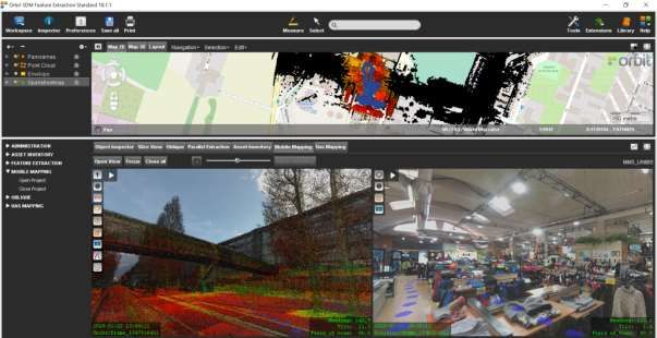
Fast Mapping and Geospatial Data Aquisition by Innovative Indoor
   Mapping System

                               Stefano CANTONI, Giorgio VASSENA, Italy

        1. INTRODUCTION

   The need of large, dense and fast 3D data acquisition in the field, is becoming more and more
   crucial in all the life of buildings and infrastructures, starting from the design, construction
   and/or renovation phases, until the short and long-term maintenance procedures. The
   continuous innovation in the 3D mobile mapping technologies makes now possible to acquire,
   at reasonable costs and in a fast way, dense point clouds of construction sites, with an
   accuracy ranging from 2 to 10 centimeters and enriched with high-resolution RGB images.
   While Outdoor Mobile Mapping Systems (MMS), usually installed on vehicles and based on
   a combination of GNSS, odometer and IMU to solve the positioning problem, have been
   reached their maturity, recent and various other solutions have been developed instead, to
   solve the problem of 3D mapping in indoor environments when GNSS signal is not available.
   In fact, outdoor MMS are based on the use of the GNSS signal to geo-reference the trajectory
   of the vehicle. Nevertheless, lack of signal and "canyoning" problems makes GNSS based
   systems ineffective in indoors and narrow environments and different mapping solutions must
   be adopted. The development of innovative indoor mapping systems needs to introduce also a
   different real time and post processing workflow, composed by different surveying strategies
   and different processing software. The result is that to fully map a construction site or a city
   model a combined use of vehicle-based MMS, indoor MMS and classical static scans
   acquisitions is often needed.
   The paper investigates and describes how a 3D survey carried on with an Innovative Indoor
   Mobile Mapping System, based on SLAM approach, has been effectively integrated with
   acquisitions coming from an Outdoor Mobile Mapping System mounted on a vehicle, static
   scans from tripod laser scanner and point clouds coming from a hand-held laser scanner
   device. The paper describes also how this multiresolution and multiplatform data have been
   managed in the way to realize a model characterized by an increasing level of detail. The goal
   of this approach is to test the right procedure to be able to provide to the final stakeholders a
   3D model with dense and large amount of information, with a variable level of detail
   diversified in function of the real needs.

        2. METHODOLOGY

            1.1 Data acquisition

   The test site of the data acquisition has been chosen as the engineering Campus of the
   University of Brescia and in the surrounding areas and buildings. Different instruments have
   been used in order to create a full indoor/outdoor model of the University district and some
   indoor environments. The main streets around the campus have been mapped thanks to a

Fast Mapping and Geospatial Data Acquisition by Innovative Indoor Mapping System (10087)
Stefano Cantoni and Giorgio Paolo Maria Vassena (Italy)
FIG Working Week 2019
Geospatial information for a smarter life and environmental resilience
Hanoi, Vietnam, April 22–26, 2019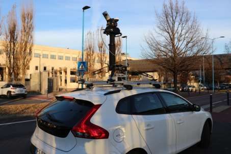
MMS mounted on a car and the point cloud model have been geo-referenced mainly thanks to
   the GNSS mounted on the instrument. The model acquired with the MMS has been used as
   reference frame for the 3D acquisitions carried on with different sensors. In fact, in order to
   acquire indoor environments a iMMS based on SLAM algorithm with a RGB camera has
   been used. Further indoor details have been mapped with a static scanner and specific details
   with an hand-held lased scanner. What made interesting and innovative this test has been the
   systematic use of automatic registration tool for the registration between the variuos point
   clouds acquired with different instruments. Only the registration between static scans and
   hand-held laser scanner data has required the use of common targets.

            1.1.1 Mobile Mapping System (Teledyne Maverick)

            To map the University district roads a Teledyne Maverick platform have been used.
            This compact MMS uses a robust and consolidate mapping approach (Teledyne,
            Maverick, 2018) enriched by some very useful tools able to speed up the control of the
            system, as the application that allows the surveyor to use a smart phone to drive and
            control the functionalities of the Maverick platform. The use of system is quite fast;
            once installed on the vehicle (Figure 1), the system just needs a short calibration before
            to start the data acquisition, driving for some minutes along a fast drive road. At the
            end of the calibration process, a 3D acquisition has been carried on, setting at 5 meters
            the distance between two consecutive RGB images shoots. In less than 10 minutes,
            three kilometers of streets have been acquired.

                                        Figure 1:Particular of Maverick MMS

Fast Mapping and Geospatial Data Acquisition by Innovative Indoor Mapping System (10087)
Stefano Cantoni and Giorgio Paolo Maria Vassena (Italy)
FIG Working Week 2019
Geospatial information for a smarter life and environmental resilience
Hanoi, Vietnam, April 22–26, 2019
1.1.2 Indoor Mobile Mapping System (Heron)
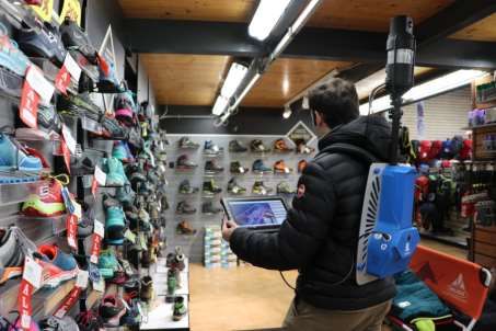
As Indoor Mobile Mapping System, the SLAM based Heron (Gexcel, Wearable
Mobile Mapping, 2018) (Ceriani et al., 2015) (Figure 2), has been used in order to
survey some indoors environments of the faculty of engineering building and of a
Sport shop positioned close to the University campus. Heron provides a 3D point cloud
with a local accuracy and resolution of 2 cm, synchronized with a full resolution RGB
camera. The characteristics of an iMMS as Heron is the capability to carry out fast 3D
surveys just walking with a backpack or an instrumented trolley along the surveyed
site. To geo-reference this kind of indoor mapping survey, it cannot be proposed the
use of geo referenced targets; this accurate but time-consuming approach would
contrast with the need of a fast and affordable approach. For this reason, the indoor
acquired point cloud has been overlapped with the point cloud acquired by the
Maverick system. The registration has been carried on using the automatic tools
present in the post processing software. To optimize the surveying time and,
consequently the amount of raw data acquired, the indoor mobile mapping procedures
have been organized planning acquisition sections of 5-10 minutes.
Figure 2: Heron survey at a shopping center located close to the University Campus
1.1.3 Static laser scanner (Faro Focus 3D X 330)
The same fully automatic registration tool available in the post processing software
(JRC 3D Reconstructor), have been successfully applied to geo-reference the high-
resolution static scans, using Faro Focus 3D scanner (Faro, Faro Focus 3D X 330,
Fast Mapping and Geospatial Data Acquisition by Innovative Indoor Mapping System (10087)
Stefano Cantoni and Giorgio Paolo Maria Vassena (Italy)
FIG Working Week 2019
Geospatial information for a smarter life and environmental resilience
Hanoi, Vietnam, April 22–26, 20192018). In this way the iMMS survey (already geo-referenced on the Maverick one) is
used, inside the building, as the reference frame to geo-reference the high resolutions
scans acquired by the Focus scanner.
1.1.4 Hand Held scanner (Dot product)
Some more details, of a portion of the indoor site, acquired with the Faro scanner, have
been 3D mapped, with very high resolution and accuracy, using the Dot Product hand
held laser scanner (Dot product, Handheld 3D capture solution, 2018). This instrument
allows to acquire high resolution point clouds starting from images, with a maximum
range of three meters. The system requires the use of various typologies of targets, and
these same targets must be visible in the Faro scans to connect the hand-held 3D point
cloud data with the Faro ones. In fact, in this case study, test have been carried out
with the available automatic registration algorithms but failed when trying to connect
tripod scans with the point clouds acquired with hand-held laser scanners.
Figure 3: particular of the target used (April tags, survey tags)
1.2 Data elaboration
The post processing data elaoration have been carried on using a a portable workstation with
an Intel Core i7-6700HQ quad core 3.5 GHz processor, 16 GB DDR4 RAM and a graphic
card Nvidia GTX 960M with 4 GB GDDR5 installed. The data of the Indoor Mobile Mapping
Systems have been post processed in a specific software where the trajectory quality is
improved with specific procedures and the final point cloud and panoramas views are
generated. All the point clouds models have been managed in the JRC 3D Reconstructor
software (Gexcel, JRC 3D Reconstructor, 2018) where the automatic pre registration tools
and ICP algorithms are available. As already mentioned, the 3D point cloud model from the
Maverick Mobile Mapping System has been georeferenced by GNSS and used as skeleton to
geo reference all the point cloud models coming from all the other instruments. The overlap
between the point clouds is crucial to run the automatic pre registration process. The final
model has been moved in the cartographic reference frame EPGS:32632 (WGS 84/UTM zone
Fast Mapping and Geospatial Data Acquisition by Innovative Indoor Mapping System (10087)
Stefano Cantoni and Giorgio Paolo Maria Vassena (Italy)
FIG Working Week 2019
Geospatial information for a smarter life and environmental resilience
Hanoi, Vietnam, April 22–26, 201932N). Finally the high resolution point clouds coming from the hand held scanner have been
registered on the static laser scanner ones, thanks to the presence of common 2D targets. The
static scans, the Heron data and finally the Maverick ones have be registred automatically.
1.3 Data visualization and Features extraction
Once all the models have been merged together and moved in a common cartographic
reference system, a top view map called "Blueprint" have been automatically generated.
These top view map (Figure 4) can provide a fast overview of the surveyed area; it is easily
measurable and exportable in AutoCAD script, giving back the surveyed area state of the art.
Moreover, it is possible to directly investigate the iMMS dataset in an effective way, thanks to
a dedicated navigation tool (Blueprint Navigator), that allows to simultaneously visualize the
high-resolution images overlapped on the point cloud acquired. The datasets coming from the
Mobile Mapping Systems have been also organized and exported according to the "Orbit"
Templates. A mobile mapping run has been created for each Mobile Mapping System
acquisition and then, merged together in the same project (Figure 5). In Orbit Feature
Extraction Standard, a worldwide well-known platform for mobile mapping data visualization
and facility management applications, point cloud and images have been investigated thanks
to the possibility to open more than one view and to simultaneously extract spatial and
geometric information. Moreover, it is possible to fill an already organized database coming,
for example, from platform as QGIS, ArcGIS etc. or directly to create a new one inside Orbit.
Figure 4: particular of the blueprint generated
Fast Mapping and Geospatial Data Acquisition by Innovative Indoor Mapping System (10087)
Stefano Cantoni and Giorgio Paolo Maria Vassena (Italy)
FIG Working Week 2019
Geospatial information for a smarter life and environmental resilience
Hanoi, Vietnam, April 22–26, 2019Figure 5: Project visualization in Orbit Feature Extraction
CONCLUSION
This case study shows how the use of various 3D surveying instruments, with different
resolution, accuracy and formats can be merged in the same platform. It is possible to create a
full 3D model of construction sites and urban areas, thanks to the performances of available
tools of automatic registration between point clouds.
3. AKNOWLEDGMENTS
The authors would like to acknowledge Gexcel and iMAGE-S for providing the used
instruments, software licenses and technical support during the data processing.
Fast Mapping and Geospatial Data Acquisition by Innovative Indoor Mapping System (10087)
Stefano Cantoni and Giorgio Paolo Maria Vassena (Italy)
FIG Working Week 2019
Geospatial information for a smarter life and environmental resilience
Hanoi, Vietnam, April 22–26, 2019REFERENCES Barsanti, S.G.; Remondino, F.; Visintini, D., 2012, Photogrammetry and laser scanning for archaeological site 3D modeling—Some critical issues. CEUR Workshop Proc.2012, 948, B1–B10. Boavida, João & Oliveira, Adriano & Santos, Bruno. (2012). Precise Long Tunnel Survey using the Riegl VMX-250 Mobile Laser Scanning System. Ceriani, S.; Snchez, C.; Taddei, P.; Wolfart, E.; Sequeira, V.; 2015, “Pose interpolation slam for large maps using moving 3d sensors,” in 2015 IEEE/RSJ International Conference on Intelligent Robots and Systems (IROS), pp. 750–757. Corso, N.; Zakhor, A., 2013, Indoor localization algorithms for an ambulatory Human operated 3D mobile mapping system. Remote Sens. 5, 6611–6646. Dot product, Handheld 3D capture solution, 2018, https://www.dotproduct3d.com/ Faro, Faro Focus 3D X 330, 2018, https://www.faro.com/en-gb/news/the-new-faro-laser-scanner-focus3d-x-330-the-perfect- instrument-for-3d-documentation-and-land-surveying-2/ Gexcel, JRC 3D Reconstructor, 2018, https://gexcel.it/en/software/jrc-3d-reconstructor Gexcel, Wearable Mobile Mapping, 2018, https://gexcel.it/en/solutions/heron-mobile-mapping Khashayar Asadi, Hariharan Ramshankar, Harish Pullagurla, Aishwarya Bhandare, Suraj Shanbhag, Pooja Mehta, Spondon Kundu, Kevin Han, Edgar Lobaton, Tianfu Wu, 2018, Vision-based integrated mobile robotic system for real-time applications in construction, Automation in Construction, Volume 96, 2018, Pages 470-482, Lauterbach, H.A.; Borrmann, D.; Heß, R.; Eck, D.; Schilling, K.; Nüchter, A., 2015, Evaluation of a backpack-mounted 3D mobile scanning system. Remote Sens., 7, 13753– 13781. Marinelli, G.; Bassani, M; Piras, M.; Lingua, A.M.; 2017, Mobile mapping systems and spatial data collection strategies assessment in the identification of horizontal alignment of highways,Transportation Research Part C: Emerging Technologies, Volume 79, Pages 257- 273, ISSN 0968-090X, https://doi.org/10.1016/j.trc.2017.03.020. Nocerino, E.; Menna, F.; Remondino, F.; Toschi, L.; Rodriguez-Gonzalvez, P., 2017, Investigation of indoor and outdoor performance of two portable mobile mapping systems. In Fast Mapping and Geospatial Data Acquisition by Innovative Indoor Mapping System (10087) Stefano Cantoni and Giorgio Paolo Maria Vassena (Italy) FIG Working Week 2019 Geospatial information for a smarter life and environmental resilience Hanoi, Vietnam, April 22–26, 2019
Proceedings of the SPIE Vol. 10332 Videometrics, Range Imaging, and Applications XIV,
   Munich, Germany, 25–29 June.

   Orbit, Geospatial Technologies, 2018,
   https://orbitgt.com/

   Schmitz, L.; Schroth, G.; Reinshagen, F., 2015, Mapping Indoor Spaces with an Advanced
   Trolley Equipped with Laser Scanners, Cameras and Advanced Software. GIM International,
   12 October 2015.

   Teledyne Optech, Maverick, 2018,
   http://www.teledyneoptech.com/en/products/mobile-survey/maverick

   Zhang, J.; Singh, S., 2015, Visual-lidar Odometry and Mapping: Low-drift, Robust, and Fast.
   In Proceedings of the 2015 IEEE International Conference on Robotics and Automation
   (ICRA), Seattle, WA, USA, 26–30 May 2015; pp. 2174–218.

Fast Mapping and Geospatial Data Acquisition by Innovative Indoor Mapping System (10087)
Stefano Cantoni and Giorgio Paolo Maria Vassena (Italy)
FIG Working Week 2019
Geospatial information for a smarter life and environmental resilience
Hanoi, Vietnam, April 22–26, 2019
BIOGRAPHICAL NOTES

   Stefano Cantoni,
   2016 bachelor’s degree in civil engineering at Brescia University
   (thesis title: Palazzo Italia Imaging survey at Expo Milano 2015: as built as designed
   comparison)
   2017-2018 Abroad thesis program at Heig-VD University (Switzerland).
   2018 master’s degree in civil and environmental engineering at Brescia University (thesis
   title: Surveying with Heron and 360° camera: from acquisition to diffusion)
   2019 Post graduated grant at the University of Brescia (Italy)

   Giorgio Vassena,
   Chair of Surveying and Mapping at the University of Brescia (Italy). Starting, at the
   beginning of his carrier, from the study of advanced methodologies for structures deformation
   and high-altitude glacier monitoring, he is actually involved in several studies on innovative
   technologies for structures and infrastructures surveying by Lidar approach.

   CONTACTS

   Stefano Cantoni, Giorgio Vassena
   Institution: Department DICATAM University of Brescia
   Address: Piazza del Mercato, 15
   City: Brescia
   COUNTRY: Italy
   Tel. +39 030 2988.1
   Email: stefano.cantoni@unibs.it, giorgio.vassena@unibs.it
   Web site: unibs.it

Fast Mapping and Geospatial Data Acquisition by Innovative Indoor Mapping System (10087)
Stefano Cantoni and Giorgio Paolo Maria Vassena (Italy)
FIG Working Week 2019
Geospatial information for a smarter life and environmental resilience
Hanoi, Vietnam, April 22–26, 2019
You can also read