Geological Study of Dasht-e-Top Sedimentary Basin, Wardak Province, Afghanistan
←
→
Page content transcription
If your browser does not render page correctly, please read the page content below
International Journal of Geosciences, 2021, 12, 531-540
                                                                                                      https://www.scirp.org/journal/ijg
                                                                                                               ISSN Online: 2156-8367
                                                                                                                 ISSN Print: 2156-8359

Geological Study of Dasht-e-Top Sedimentary
Basin, Wardak Province, Afghanistan

Hafizullah Rasouli, Shekeb Shamal, Mohammad Hasib Sarwari

Department of Geology, Geoscience Faculty, Kabul University, Kabul, Afghanistan

How to cite this paper: Rasouli, H.,              Abstract
Shamal, S. and Sarwari, M.H. (2021) Geo-
logical Study of Dasht-e-Top Sedimentary          This study is conducted to investigate the occurrence of various geological
Basin, Wardak Province, Afghanistan. Inter-       features, and to study the geology and soil characteristics of the study area. To
national Journal of Geosciences, 12, 531-540.
                                                  achieve the objective of this research collection, different samples from dif-
https://doi.org/10.4236/ijg.2021.126029
                                                  ferent locations in study area were collected, analyzed in laboratory, and the
Received: March 7, 2021                           results are compared with each other. The main rock types found in the study
Accepted: June 14, 2021                           area were metamorphic rock (Gneiss) and igneous rock (Granite), and the
Published: June 17, 2021
                                                  main soil types found were Loam, sandy and silty soils with different soil
Copyright © 2021 by author(s) and                 structures (e.g. crumbling, platy, single grain, granular and prismatic). Cal-
Scientific Research Publishing Inc.               cium carbonate, Iron oxides and different sizes of sediments were also seen in
This work is licensed under the Creative
                                                  the soil profile, where the size of sediments were changing as it was course
Commons Attribution International
License (CC BY 4.0).                              size sediments and gravels near the mountain range and as going far from the
http://creativecommons.org/licenses/by/4.0/       mountain it was changed to fine size sediments like sand, silt and clay. The
                Open Access                       river terraces present in the area cover different geological structures such as
                                                  angular and erosional unconformities, thinning out of strata and potholes.
                                                  The mountain range surrounded the study area contains different observable
                                                  tectonic structures such as anticline, syncline, vines (dyke, sill and apophasis).
                                                  Furthermore, different types of valleys also existed in this area.

                                                  Keywords
                                                  Petrography, Sediment Size, Soil Structure, River Terraces, Tectonic
                                                  Structures, Geomorphology, Calcium Carbonate

                                                1. Introduction
                                                Dasht-e-top sedimentary basin is located 50 km west of Kabul in the Wardak
                                                province [1]. The surrounding mountains of Dasht-e-top are mainly composed
                                                of metamorphic and igneous rocks [2] [3], where, they are the essential part of
                                                the Paghman mountains range. Further information regarding gneisses of these

DOI: 10.4236/ijg.2021.126029         Jun. 17, 2021                  531                           International Journal of Geosciences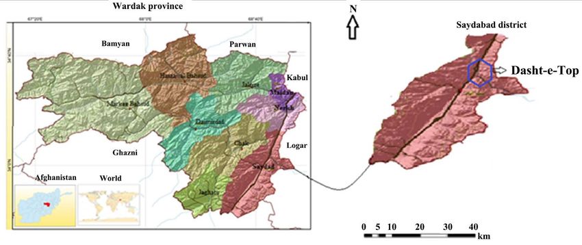
H. Rasouli et al.

                               mountains have need of both sedimentary and pedologic research with details
                               [4]. The accumulated sediments are mostly clay, loam, sand and gravels, which
                               are deposited in plane parts of the basin. The thickness of sediments depends on
                               slope and distance from the mountains, and the basin has located at the two
                               sides of Kandahar-Kabul highway and both sides are plane up to two km, but
                               close to the mountain there are hills and sloppy areas. All materials from differ-
                               ent points of mountains are transported by floods and deposited at different
                               parts in this basin [5] [6]. The age of sediments in this basin is Neogene-Pleis-
                               tocene, and the sediment are in their normal position in the basin, where the
                               lower layers are Neogene and the upper layers have Pleistocene age [7]. The
                               Quality of sediments are directly referred to the type of mother rocks which
                               eroded in the mountains. The size of materials also related to the distance of
                               transportation from mountain ranges around the basin, where generally near to
                               the mountains the sediments have very course to course sizes which include
                               boulder, cobble, pebble and granules and with distance from mountains the size
                               of material changes from fine to very fine and includes Sand, Silt and Clay. In
                               mountainous area and its skirts, the grains are angular and sub angular but as
                               getting far from mountains the grains become sub round and rounded [8] [9]
                               [10]. In the soil profiles and river terraces different layers of materials can be
                               seen, which is mainly due to oxidation, reductions and presence of CaCO3 and
                               organic materials. Where, the red color shows oxidation and solution of iron
                               oxide, white color is due to reduction and CaCO3 and the dark color is because
                               of organic materials, that decomposed at the different periods of geology [11]
                               [12] [13].

                               2. Materials and Methods
                               Generally, this research includes two parts.

                               2.1. Field Work
                               Field works are generally consisting the selection of points, collecting of the
                               samples from the mountains (from different rock types present), field study of
                               the sediments and all unconsolidated materials, study of the river terraces, Soil
                               profiles, and existent structures of the area.

                               2.2. Laboratory Works
                               The laboratory works include the following procedures:
                                 Air drying and oven drying of the collected sedimentary samples at 30˚C for
                               24 hours, sieve analysis for determination of grain sizes of the soil samples, de-
                               termination of CaCO3 by using calcimeter, and using of Polarized light micro-
                               scopes for microscopic studies of the rock samples.

                               3. Description of Site Studies
                               This study was carried out in Dasht-e-top sedimentary basin (Figure 1) which is

DOI: 10.4236/ijg.2021.126029                        532                         International Journal of Geosciences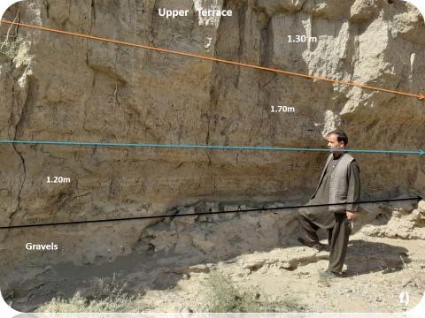
H. Rasouli et al.

                       Figure 1. Location map of Dasht-e-top sedimentary basin, Wardak, Afghanistan.

                                     a sub-basin of Wardak province. The study area is located between Logar,
                                     Paghman and Kabul Rivers, where Logar river flows at the west side of this basin
                                     [14] [15] [16]. Kabul River is located at the east, Paghman River and its moun-
                                     tain range are located at the south-east side of the study area. The total area of
                                     this basin is 6 km2 [17] [18] [19].

                                     4. Results and Discussion
                                     Generally the mountain ranges surrounding this sedimentary basin are consist-
                                     ing from metamorphic rock (Gneiss) and Igneous rock (Granite), and the ac-
                                     cumulated sediments in this basin are Loam, Sands and Silts. The soil profile and
                                     river terraces in the area are showing different soil structures such as crumbling,
                                     platy, single grain, granular and prismatic. Furthermore, in the soil profile mostly
                                     CaCO3, iron oxides and different sizes of sediments can be seen, where the size
                                     of sediments are belonging to their travel distance from surrounded mountain
                                     ranges. Generally, sediments near to the mountain range are course size (e.g.
                                     gravels) and as we get away from mountains the grain size changes from fine to
                                     very fine Sands, Silt and Clay. River terraces are consisting of different structures
                                     of angular and erosional unconformities, layering thinning out and potholes. In
                                     mountainous areas, there are different tectonic structures such as anticline, syn-
                                     cline and different type of valleys.

                                     5. Geomorphology of Dasht-e-Top
                                     Generally, Dasht-e-top basin consists three types of relief, where the first type is
                                     sloppy areas, second is Skirt areas and hills and the third type is plain areas
                                     which are located at about 1 km at the two sides of Kabul—Kandahar road [20]
                                     [21]. The surrounding mountains of this basin is like ring (bowel) which is an
                                     inter mountains back basin [22].

                                     6. Geology
                                     The surrounding mountains of Dasht-e-top are formed from plutonic and me-

DOI: 10.4236/ijg.2021.126029                               533                          International Journal of Geosciences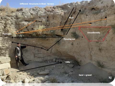
H. Rasouli et al.
tamorphic rocks (Granite, Gneiss). The mountains which surrounded this basin
are belong to Paghman mountain range and it continue from NE to SW. Analy-
sis of course sediments show that parent rocks are Gneiss and Granite and are
present with different sizes in this basin (e.g. bolder, cobbles, pebbles and gra-
nules). In the surrounded mountain ranges, different types of valley structures
such as longitudinal, diagonal, transverse, anticlinal and synclinal with magmat-
ic inclusions like dikes and sills were also observed [23] (Figure 3). Further-
more, different types of sedimentary features like alluvial fans and alluvial
aprons were also seen in the area (Figure 5).
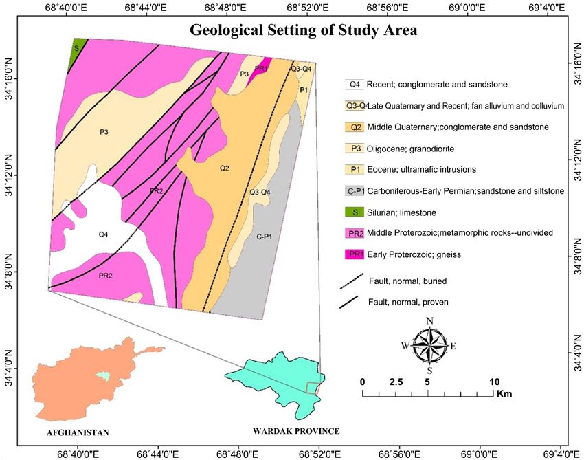
7. Country Rocks and Rock Boundaries
The mountains of Dasht-e-Top have different lithology and geological age, there
are close relation between rock boundaries, where the main rock types are
gneisses and Granite which have Proterozoic age [23]. The contact zones of these
rocks are different in different locations, in some areas Granite has contact with
gneisses and in some parts, it is also observable with volcanic rocks which are
younger than Granite and gneisses. These volcanic rocks are the Evidences to the
occurrence of volcanic eruptions in the area [24] [25]. Different types of tectonic
structures such as veins, dyke’s sills and apophasis are observable in the above-
mentioned country rocks, and these rocks generally strikes from NE to SW and
the surface dip is from N to SW (Figure 2, Figure 4).
Figure 2. Geological map of Dasht-e-top sedimentary basin.
DOI: 10.4236/ijg.2021.126029 534 International Journal of Geosciences
H. Rasouli et al.

                                  Figure 3. Different geological structures in Dasht-e-top basin.

                                  Figure 4. Different contact zones in gneiss and granite.

                               8. Alluvial Fans
                               Dasht-e-Top sedimentary basin is relatively plane with many and different types
                               of alluvial fans, these sedimentary features contains different types and sizes of
                               sediments such as gravels, sands, silts and clay, whereas the grain size of sedi-
                               ments are related to the their transportation distance from mountains range,
                               generally as we get close to the mountains range the grain size changes from
                               Course to very Course (boulder, cobble, pebble and granule) and as we get away
                               from mountains the grain sizes change from fine to very fine sediments (sands,
                               silt and clay) (Figure 5).

DOI: 10.4236/ijg.2021.126029                         535                            International Journal of Geosciences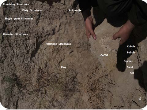
H. Rasouli et al.

                                         Figure 5. Alluvial fans and different sizes of materials.

                               9. Imbrication Bedding
                               Imbrication beddings has been clearly observed in this sedimentary basin, where
                               their presence indicates the occurrence of several flooding’s at different time pe-
                               riods. From analysis of the observed imbrication beddings, it is found that it
                               contains different types of sedimentary materials which are eroded from differ-
                               ent parent rocks, mainly Quartzite, Gneiss, and Granite. Where the main miner-
                               al composition of the main rocks available was Quartz, Feldspars, Garnets, and
                               mica minerals. The mentioned bedding type observed, has alternate layers of
                               different sizes of sediments, where it also can be due to periodic occurrence of
                               flooding in the area (Figure 6).

                               10. River Terraces and Soil Profiles
                               The soil profile studied in the study area include different layers of soil which
                               contains cracks and joints, also the roots of plants are visible up to about 1.15m
                               depth. Several small caves which are made by insects and worms can be seen as
                               well. The river terraces present in the area has mainly contains fine sedimentary
                               material such as sand, silt and clay, where from that, it can be judged that there
                               were laminar flows at the area in the past (Figure 7).
                                 The river terraces studied contains different sedimentary structure such as
                               potholes, angular and erosional unconformities, and layer thinning outs. Fur-
                               therer more, as there is no specific arrangement in the present sedimentary ma-
                               terial in the area, it can be judged as due to the different flow directions (Figure
                               7 & Figure 8).
                                 The specific soil profile studied in the area contains different soil structures
                               such as crumbling, platy, single grain, granular and prismatic. Furthermore, the
                               profile were consisting from sands, silts, and clay, with thin layers of course ma-
                               terial (gravel), and in general the soil type can be judged as clayey Loam, where
                               organic material and CaCO3 depositions were also available in the seen profile
                               (Figure 9 & Figure 10).

DOI: 10.4236/ijg.2021.126029                        536                             International Journal of Geosciences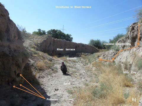
H. Rasouli et al.

                               Figure 6. Imbrication bedding with different types and sizes of sediments at Dasht-e-top
                               sedimentary basin.

                                          Figure 7. Upper part of River terrace at the Dasht-e-top basin.

                                  Figure 8. Different structures in river terrace at the Dasht-e-top sedimentary basin.

DOI: 10.4236/ijg.2021.126029                         537                             International Journal of Geosciences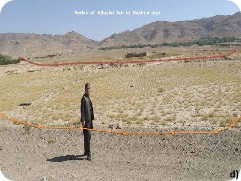
H. Rasouli et al.

                                       Figure 9. Dry river profile and river terraces in Dasht-e-top basin.

                                       Figure 10. Soil profile in Dasht-e-top basin.

                               11. Conclusions
                               All sedimentary basins in Afghanistan are belonging to the Paleogene (Eocene
                               ad Oligocene) with the age of about 47 - 23 million years and are located in in-
                               termountain valleys, where, the different types of sediments deposited between
                               these basins are called Paleogene formations. The sedimentary materials present
                               in these basins related to the surrounded mountain ranges which are eroded and
                               transported by different agents, and the above general characteristics are also
                               specifically applicable in Dasht-e-top sedimentary basin.
                                 Furthermore, Dasht-e-top sedimentary basin is specifically an intermountain
                               backing basin where its surrounding mountains which it look like a bowel. The
                               river terraces present in this basin are formed at different geological time periods
                               and one after another.
                                 Summarily, this study expressed the geology, river terraces and soil profiles in

DOI: 10.4236/ijg.2021.126029                        538                                International Journal of Geosciences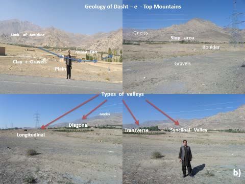
H. Rasouli et al.

                                the Dasht-e-top sedimentary basin of Wardak province, Afghanistan. Where, the
                                obtained results suggest that further in-depth studies and researches on its soil
                                physical and chemical properties, it’s all other geological and sedimentological
                                characteristics with special care and accuracy should be performed.

                                Acknowledgements
                                We would like to express our warm gratitude to anonymous referees for their
                                valuable comments. I extend our thanks to our faculty members who helped us
                                put this paper together.

                                Conflicts of Interest
                                The authors declare no conflicts of interest regarding the publication of this pa-
                                per.

                                References
                                [1]    Anthony, E.J. and Héquette, A. (2007) The Grain-Size Characterization of Coastal
                                       Sand from the Somme Estuary to Belgium: Sediment Sorting Processes and Mixing
                                       in a Tide- and Storm-Dominated Setting. Sedimentary Geology, 202, 369-382.
                                       https://doi.org/10.1016/j.sedgeo.2007.03.022
                                [2]    Coe, A.L. (2003) The Sedimentary Records of Sea Level Change. British Library, 46.
                                [3]    Ball, M.M. (2003) Carbonate Sand Bodies of Florida and Bahamas. Journal of Sedi-
                                       mentary Petrology, 37, 556-591.
                                [4]    Belhassan, K. (2020) Hydrogeology of the Ribaa-Bittit Springs in the Mikkes Basin
                                       (Morocco). International Journal of Water Resources and Environmental Science,
                                       9, 7-15.
                                [5]    Belhassan, K. (2020) Relationship between River and Groundwater: Water Table
                                       Piezometry of the Mikkes Basin (Morocco). International Journal of Water Resources
                                       and Environmental Science, 9, 1-6.
                                [6]    Broshears, R.E., Akbari, M.A., Chornack, M.P., Mueller, D.K. and Ruddy, B.C.
                                       (2005) Inventory of Ground-Water Resources in the Kabul Basin, Afghanistan: U.S.
                                       Geological Survey. Scientific Investigations Report 2005-5090, 34 p.
                                       https://doi.org/10.3133/sir20055090
                                [7]    Bohannon, R.G. and Turner, K.J. (2007) Geologic Map of Quadrangle 3468, Chak
                                       Wardak-Syahgerd (509) and Kabul (510) Quadrangles, Afghanistan: U.S. Geological
                                       Survey. Open-File Report 2005-1107-A. 1 Sheet.
                                [8]    Bohannon, R.G. (2005) Geologic Map of Quadrangle 3468, Chak-e-Wardak (509)
                                       and Kabul (510) Quadrangles: Afghan Open-File Report (509/510) 2005-1001.
                                [9]    Colella, A. and di Geronimo, I. (1998) Surface Sediments and Macro Fanas of the
                                       Grati Submarine Fan (Ionian Sea, Italy) Sedimentary Geology. 77.
                               [10]    Elliott, T. (1999) Deltas. In: Reading, H.G., Ed., Sedimentary Environments and Fa-
                                       cies, 2nd Edition, Blackwell Scientific Pub., Oxford, 154.
                               [11]    Arian, H., Kayastha, R.B., Bhattarai, B.C., Shrestha, A., Rasouli, H. and Armstrong,
                                       R. (2015) Application of the Snowmelt Runoff Model in the Salang River Basin,
                                       Afghanistan Using MODIS Satellite. Journal of Hydrology and Meteorology, 9, 109-118.
                                       https://doi.org/10.3126/jhm.v9i1.15586
                               [12]    Elliontt, T. (2001) Siliciclastic Shorelines Sedimentary Environments and Facies.

DOI: 10.4236/ijg.2021.126029                            539                           International Journal of Geosciences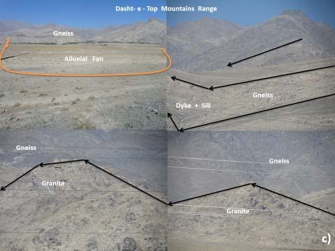
H. Rasouli et al.

                                      2nd Edition, Blackwell Scientific Pub., Oxford, 85.
                               [13]   Folk, R.L. (2004) Spectral Division of Limestone Types. In: Hamm, W.E., Ed., Clas-
                                      sification of Carbonate Rocks, Memoirs of the American Association of Petroleum
                                      Geology, Tulsa, 62-84, 97.
                               [14]   Goff, J., McFadgen, B. and Chagué-Goff, C. (2004) Sedimentary Differences be-
                                      tween the 2002 Easter Storm and the 15th-Century Okoropunga Tsunami, Southeas-
                                      tern North Island, New Zealand. Marine Geology, 204, 235-236.
                                      https://doi.org/10.1016/S0025-3227(03)00352-9
                               [15]   Horikawa, K. and Ito, M. (2009) Non-Uniform Across-Shelf Variations in Thick-
                                      ness, Grain Size, and Frequency of Turbidities in a Transgressive Outer-Shelf, the
                                      Middle Pleistocene Kakinokidai Formation, Boso Peninsula, Japan. Sedimentary Ge-
                                      ology, 220, 105-110. https://doi.org/10.1016/j.sedgeo.2009.07.002
                               [16]   Kortekaas, S. and Dawson, A. (2007) Distinguishing Tsunami and Storm Deposits:
                                      An Example from Martinhal, SW Portugal. Sedimentary Geology, 200, 208-210.
                                      https://doi.org/10.1016/j.sedgeo.2007.01.004
                               [17]   Morton, R.A., Gelfenbaum, G. and Jaffe, B.E. (2007) Physical Criteria for Distin-
                                      guishing Sandy Tsunami and Storm Deposits Using Modern Examples. Sedimenta-
                                      ry Geology, 200, 184-189. https://doi.org/10.1016/j.sedgeo.2007.01.003
                               [18]   Leeder, M. (2006) Sedimentology and Sedimentary Basins. Grphicraft, Ltd., Hong
                                      Kong, Raplika Press Pvt. Ltd., Kundli, 193.
                               [19]   Rasouli, H., Kayastha, R.B., Bikas, C.B., Ahuti, S., Arian, H. and Armstrong, R.
                                      (2015) Estimation of Discharge from Upper Kabul River Basin, Afghanistan Using
                                      the Snowmelt Runoff Model. Journal of Hydrology and Meteorology, 9, 85-94.
                                      https://doi.org/10.3126/jhm.v9i1.15584
                               [20]   Rasouli, H. (2017) Study on River Terraces in Upper and Middle Parts of Kabul Se-
                                      dimentary Basin, Afghanistan. International Journal of Science and Research (IJSR),
                                      6, 1696-1704.
                               [21]   Rasouli, H. (2019) A Study on Some River Sediments, Hydrology and Geological
                                      Characteristics in Chak Sedimentary Basin, Wardak, Afghanistan. International Jour-
                                      nal of Geology, Earth and Environmental Sciences, 9, 49-61.
                               [22]   Ruleman, C.A., Crone, A.J., Machette, M.N., Haller, K.M. and Rukstales, K.S. (2007)
                                      Map and Database of Probable and Possible Quaternary Faults in Afghanistan: U.S.
                                      Geological Survey. Open File Report 2007-1103, 39 p.
                               [23]   Rubin, D.M.A. (2004) Simple Autocorrelation Algorithm for Determining Grain
                                      Size from Digital Images of Sediment. Journal of Sedimentary Research, 74, 160-165.
                                      https://doi.org/10.1306/052203740160
                               [24]   Sedgwick, P.E. and Davis, R.A. (2003) Stratigraphy of Washover Deposits in Flori-
                                      da: Implications for Recognition in the Stratigraphic Record. Marine Geology, 200,
                                      31-32. https://doi.org/10.1016/S0025-3227(03)00163-4
                               [25]   Sun, Y., Gao, S. and Li, J. (2003) Preliminary Analysis of Grain-Size Populations
                                      with Environmentally Sensitive Terrigenous Components in Marginal Sea Setting.
                                      Chinese Science Bulletin, 48, 184-186. https://doi.org/10.1360/03tb9038

DOI: 10.4236/ijg.2021.126029                           540                            International Journal of Geosciences
You can also read