Going My Way: a user-aware route planner
←
→
Page content transcription
If your browser does not render page correctly, please read the page content below
Going My Way: a user-aware route
                               planner

Jaewoo Chung                                          Abstract
Media Laboratory, MIT                                 Going My Way is a mobile user-aware route planner.
20 Ames St. E15-384C                                  The system learns a user’s everyday routes and
Cambridge, MA 02139 USA                               provides directions from locations along those routes.
jaewoo@media.mit.edu                                  The mobile phone client application logs GPS
                                                      information in real-time, and translates this information
Paulina Modlitba                                      into a route model. When a user requests directions to
Media Laboratory, MIT                                 a destination, the phone client sends the route
20 Ames St. E15-384C                                  information to our custom server application, which
Cambridge, MA 02139 USA                               then retrieves the directions from on the basis on the
paulina@media.mit.edu                                 user’s every-day route to the desired destination. Going
                                                      My Way provides directions, if available, based on
Chaochi Chang                                         personal landmarks rather than street names and
Media Laboratory, MIT                                 intersections. The main goal is to reduce the user’s
20 Ames St. E15-384C                                  cognitive load by simplifying and personalizing
Cambridge, MA 02139 USA                               directions; guiding the user to his or her destination by
ccchang@media.mit.edu                                 using knowledge of where the user has been and what
                                                      he or she cares about.

                                                      Keywords
                                                      Personal navigation, pedestrian navigation, location
                                                      awareness, personal landmarks, mobile computing,
                                                      human-computer interaction, HCI, context awareness

Copyright is held by the author/owner(s).
                                                      ACM Classification Keywords
CHI 2008, April 5 – April 10, 2008, Florence, Italy
                                                      H5.m. Information interfaces and presentation (e.g.,
ACM 1-xxxxxxxxxxxxxxxxxx.
                                                      HCI): Miscellaneous.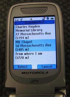
2

Introduction                                                directions. Especially in cities, where the number of
Consider a situation in which you ask a friend of yours     landmarks is large, manual systems quickly become
for directions, for example to the restaurant “Kaya” in     inefficient since the users would have to enter a large
Cambridge, MA. Rather than describing the whole             number of locations in order to maximize the system’s
route, your friend probably would begin by asking you       usefulness.
about other places, located near or on the way to the
destination, which you may be familiar with. These          Thus, automatically detecting and tracking the users’
places may be public landmarks or just locations (we        locations is inevitable when it comes to solving these
call them “personal landmarks”) that you and your           limitations. Today, it is possible to detect a user’s
friend have visited together. Alternatively, your friend    salient locations by using various location-based
may know you well enough to feel comfortable with           techniques,     such     as    clustering   algorithms
guessing which places you are familiar with. By using       [1][4][10]and tracking of GPS signal loss in indoor
the knowledge, your friend then provides you with           locations. [9] However, these techniques cover only a
directions from that personal landmark to the               limited number of the places that the user may
destination: “You know that store on Main Street that       recognize, for example “home” and “work” but no
sells funny T-shirts? Restaurant Gaia is just across the    locations in between.
street from it.
                                                            Although the detected salient (i.e. often visited)
On the other hand, the directions that you get from         locations can be used as landmarks, a user may also
route planning systems and applications, such as web        recognize other locations and buildings along his or her
based map services (e.g. Google, Yahoo) or car              frequently visited paths (e.g. the Post Office or
navigation devices, is normally not based on knowledge      Starbucks), although he or she never actually visited
about which locations are familiar to you. Some map         the specific location. People often use these landmarks
and navigation systems allow users to mark waypoints        to navigate from one place to another and use these
as intermediate stops along the destination. This option    landmarks to give people directions. [8][3]
can be used to reroute the direction to include the
user’s familiar paths, but the option requires that the     This approach is useful when it comes to finding a new,
user makes the effort to manually manipulate the            unknown location in a familiar territory, since it is likely
direction based on his or her recognition of locations on   that many landmarks within that territory are familiar
the map.                                                    to the user. Thus, the sought-after destination could be
                                                            around the corner from the user’s local grocery store,
In the other hand, MyRoute [12] is able to generate         or adjacent to the street the user walks from the
directions based on a user’s familiar locations that are    subway train to work. Therefore, in our system, we pay
close to the destination. The main limitation of this       more attention to the information along the paths than
approach is that the user need manually provided the        to the endpoints and salient locations of the user.
user’s familiar landmarks in order to personalize the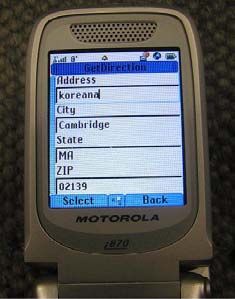
3

In this paper, we present a system, Going My Way,            newly collected GPS geo-coordinates, speed and
which aims to detect and utilize information about the       accuracy. Each cell in the low resolution grid contains
user’s personal landmarks, which are recognized along        the corresponding high resolution cells that are covered
his or her frequently visited paths, in order to guide the   by it. When a new GPS coordinate is received by the
user to his or her final destination. The remainder of       device, the system registers the coordinates to
this paper contains a more detailed description of the       corresponding high resolution grid and increments the
system and interface, as well as of the main user study      number of hits in the cell. If the cell’s GPS coordinate-
that underlies the system’s personal landmark                accuracy is higher than the newly received one, the
algorithm.                                                   system does not update the coordinates of newly
                                                             obtained one to keep the model in higher accuracy.
Approach
As described in the introduction, the main goal of the       When the user travels between locations in his or her
Going my way system is to improve route finding              daily life, the number of hits increases. This model
systems by implementing more human-like directions.          naturally captures both the significant places and
In order to achieve this, three steps are required. The      frequently visited path. When the user asks for
steps are as follows: (1) collecting the user’s location     directions to a destination, the high hit number cells
information to enable the system to identify the user’s      are used for select landmarks around/near the
traveling patterns, (2) identifying personal landmarks       destination.
that are as close as possible to the desired destination,
given by the user, and (3) generating direction. The         Preparing personal landmarks that are close to
following subsections will describe each of these three      the destination: Personal landmarks are generated
steps in depth.                                              automatically by the system when the user request for
                                                             directions to a desired location. The destination can be
Collecting the GPS trace for identifying frequent            provided as an address (e.g. 95 Main Street), a service
path: A GPS equipped mobile device, such as a cellular       description (e.g. the Post Office), or a specific company
phone or a car navigation system, is required to log         or location name (e.g. restaurant Kaya). When the
location information and enable our system to acquire        destination information is submitted, the system uses
information about where the user has been. The               the Geographic Information System (GIS) to get the
accumulated GPS data is then used to generate the            GPS coordinates of the destination, and thereafter
user-specific route model that contains the user’s           identifies the low resolution cell (proximity 2.5 km2)
frequently visited locations and paths.                      that covers the location. Within the cell, the system
                                                             attempts to select the 10 cells that have the highest hit
The route model in Going My Way consists of two              numbers. Then, the system searches for another 10
layered squires, high and low resolution grid systems,       cells in 1st peers (adjacent 8 cells which cover
sized 50 meters and 1.6 km. Each cell in the high            proximately 20 km2). These cells are negatively
resolution grid has the property of the number of hits,      weighted based on the distance from the destination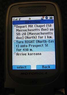
4

and positively based on the number of hits. Finally, the
system picks the 10 mostly weighted cells as landmarks.
The system avoids picking landmarks from two
adjacent areas by checking the distance between the
landmarks.

The main problem with this approach is that we do not
know whether these locations are on or near the
landmarks that the user actually recognizes. When the
system picks landmarks, it can pick landmarks from a
cell that contains identified salient locations. However,
the system may also need to pick landmarks from cells
that only contain paths between salient locations. For
instance, a user may pass by a specific Starbucks           Figure 1. Left picture shows the snapshot of destination input
coffee shop every day but never actually visits the shop.   screen, and right picture shows the disambiguating screen
The system needs to pick locations based only on the
fact that GPS traces were collected nearby the coffee       When the target location has been identified, the
shop. Should the system randomly select the location?       system shows a list of computed personal landmarks
Why is that particular Starbucks a better selection than    that are (1) close to the target location and (2) are
a restaurant nearby? One way of picking landmarks is        likely to be recognized by the user. Landmarks are
to implement user preference profiles. Another way is       provided as text descriptions of the location (the exact
to find a general recognition model of the user’s           name is included if possible), e.g. “Starbucks in Central
recollection of locations. We have chosen the latter        Square”, and the linear distance from the landmark to
approach. In the next section, we present the results of    the destination. The information format was chosen
an experiment on which our user model has been built.       based on the results of our main experiment, presented
                                                            below.
User Interface: Getting a list of directions requires
only a few steps. First, the user needs to provide an       Generating Direction: Directions from the confirmed
address or the name of the destination in text format       landmark and the desired destination is then generated
by using the phone keypad. When the system finds            in text format. If a landmark has a specific name, e.g.
more than one location for the submitted address (or        “Star Market”, the name is included in addition to the
the place name) the system lists the found locations        specific address.
and asks the user to selecting an item from the list.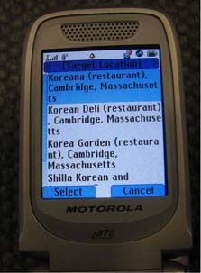
5

                                                            personalized directions. The system version described
                                                            in the paper collects location and route information
                                                            automatically in order to provide personalized
                                                            landmarks.

                                                            Implementation: The system contains of two main
                                                            parts: a GIS server (back-end) and a phone application
                                                            (front-end). The phone application was developed using
                                                            Java for Micro-Edition (J2ME) on a Motorola iDen 870
                                                            phone, and the server was developed on the C# .NET
                                                            platform for Microsoft Windows XP.

                                                            The phone application, in its turn, also consists of two
                                                            parts: the route learning algorithm and the user
Figure 2. A screen shot of a phone showing directions.      interface (for fetching and showing directions). The
                                                            route learning algorithm was developed based on a
In the previous prototype of Going My Way, we let           previously developed system called Contella [2]. The
users label their salient location manually. In addition,   main function of the interface is to pass text
the users could enable the system to record and learn       information (an address of the destination) to the
routes between those labeled locations. The user-           server and display the directions thereafter returned by
provided contextual information - labels and users          the server.
frequent route information between them - allows the
system to generate more natural directions based on         Our GIS server is built on top of Microsoft’s MapPoint
the user’s own experiences. Below, follows an example       API. The server finds the nearby names of restaurants
of a learned route that connects a user’s home and          and hotels and generates a list of directions. The server
office with a route via Arlington Street:                   and the clients communicate via UDP over an iDEN data
                                                            networks.
    •    On your way ‘HOME’ from the ‘OFFICE’, turn
         LFET at the Starbucks (on Arlington St.) onto      Experiment Setup
         Medford St. for 60 meters.                         As a part of the system design and implementation, we
                                                            conducted a set of experiments to study how people, in
    •    Arrive at the post office.                         general, recognize and memorize different types of
                                                            objects   (e.g.    business,  buildings,    signs  and
Because the system knows the current location of the        monuments) at different types of locations. We also
user, and is able to identify the known location closest    chose to study if the way in which the location
to the final destination, the system is able to generate    information is presented (text description, address, or
6
image) influences people’s perception of them. We Based on the results, we identified the streets that all
started with the hypothesis that: subjects claimed to be familiar with – an overall
distance of approximately 2.5km.
1. People recognize objects which are located at
intersections better than objects that are Along these streets, we then selected a set of 20
located somewhere along a street. locations that are either at an intersection (10) or
somewhere along a street (10), and that are either part
2. People recognize and locate well-known chains of a chain (11) or are unique to that area (9).
(e.g. Starbucks) better than unique places and
stores. In the second phase, we divided the participants into
three subgroups (Group A to C) and presented each
3. People recognize and locate locations better location in one of three possible ways (text, address,
when they are presented as descriptions in text image), as seen in Table 1. Each group consists of two
(e.g. “Starbucks right next to the big Star newbie and two residents who lived the place for more
Market”) than when they are presented as than a year.
addresses (e.g. 95 Main Street) or as images.
Group A Group B Group C
4. The more time people spend in an area, the
Place 1 Image Place name Address
better they become at recognizing and locating
buildings and locations in that particular area. Place 2 Address Image Place name
Experiment settings: We recruited 12 subjects for … … … …
the experiment; 6 women and 6 men of various
Place 20 Place name Address Image
nationalities. Apart from one subject who is currently
working at MIT, the subjects are all graduate students
Table 1. The table shows how the representation types of the
at MIT. The subjects all mentioned either walking or
locations are distributed to each group.
biking as their main transportation mode. Half of the
subjects were new to the area and had lived there no
The participants were asked to fill in their answers in an
more than 2 weeks; the other half has been living in
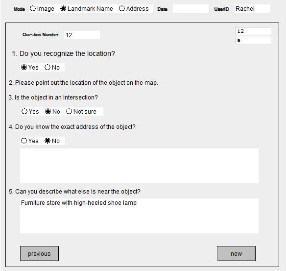
electronic questionnaire, as shown in Figure 3.
the area for more than a year. In the first phase of the
experiment, we gave the participants a simplified map
of the area and asked them to mark the streets that
they have visited at least once with a blue marker.
Then, we asked them to mark the streets that they are
“most familiar with” with a red marker.7
After the experiment, the answers were examined and
compared to a pre-marked key map to determine
whether the subjects actually recognize the objects and
locations and remember their correct location. During
the correction procedure, an error margin of 1 block
was applied for locations and buildings that are located
along a street. For buildings and locations at
intersections, the subjects had to identify the correct
intersection for it to count as a correct answer..
Results
To conclude, the study results both confirmed and
contradicted our hypotheses. In this section the results
that we think are most significant are described and
discussed. The results are directly compared with the
hypotheses stated above (see section Experiment
Setup).
In the user study, the overall uncorrected recognition
rate was 130/240=54.2%. Out of these 130 answers,
Figure 3. The screen shot of the experiment questionnaire. 57 (43.8%) were incorrect (false positive/error I).
First, the subjects were asked to find whether they 1. People recognize objects which are located at
recognize the presented objects or locations at all. As intersections better than objects that are
mentioned above, the objects and locations were located somewhere along a street.
presented as either a text description (e.g. “Starbucks
by the Main Street Subway station”, an address (e.g. Result: True. Out of a total of 130 locations
“95 Main Street”), or an image. No cross-testing (e.g. and buildings that were marked as recognized,
image and text simultaneously) was conducted in this the subjects claimed to recognize 63 (48.5%)
particular experiment. If the subjects recognized the as located in intersections. 56 of these claims
location, they were asked to mark out the location on a were correct (Group A: 21; Group B: 35). Thus,
map. Then, the subjects were asked to specify if the the accuracy rate was 56/63=88.9%. 11
location is at an intersection or somewhere along a answers were “not sure”. When it comes to
street, as well as specify the full address of the location locations and buildings that are located along a
(if they know it). Finally, subjects were asked to street, the subjects thought they recognized 42
describe what else, if anything, is near the location. (32.3%), but 15 of these were incorrect. Thus,8
a total of 27 (A: 9; B: 18) were correctly images was higher than for both text
identified; an accuracy rate of 27/42=64.3%). descriptions and addresses.
The remaining 13 answers were “not sure”.
4. The more time people spend in an area, the
2. People recognize and locate well-known chains better they become at recognizing and locating
(e.g. Starbucks) better than unique places and buildings and locations in that particular area.
stores.
Result: True. A total of 240 questions were
Result: False. Whereas a total of 29 out of 132 asked during the experiment; 20 per subject.
chain/franchise stores and restaurants were Thus, out of these 240 questions, 120
correctly recognized (A: 12; B: 17), 47 out of questions were answered by subjects who were
108 unique stores and restaurants were new to the area, and 120 questions were
correctly identified (A: 20; B: 27). Thus, the answered by subjects who were familiar with
overall recognition rate is 29/132=22.0% the area1. The overall recognition rate for the
(accuracy rate: 29/55=52.7%) for chains and subjects was (130-57)/240=30.4%; (51-
47/108=43.8% (accuracy rate: 47/74=63.5%) 24)/120=22.5% 2 in group A and (79-
for unique places and buildings. 33)/120=38.3% in group B. Thus, the overall
error rate for the two groups was (A)
3. People recognize and locate locations better 24/51=47.1% and (B) 33/79=41.8%. When it
when they are presented as text descriptions comes to accuracy rate (correctly recognized
(e.g. “Starbucks right next to the big Star locations/locations perceived as recognized by
Market”) than when they are presented as the subject), group A got an equally good or
addresses (e.g. 95 Main Street) or as images. better rate than group B for text descriptions
(A: 69.2%; B: 66.7%), addresses (A: 50%; B:
Result: True. Totally, 52 images were marked 50%), places/buildings in streets (A: 64.3%;
as recognized, of which 26 were incorrect and B: 64.3%), and chains (A: 63.2%; B: 47.2%).
26 correct (recognition rate: 26/80=32.5%; This could indicate that (1) text descriptions
accuracy rate: 26/52=50%). The are best for both people who are familiar with
corresponding numbers for text description and the area and for people who are relatively new
address are 44/14 (recognition rate:
30/80=37.5%; accuracy rate: 30/44=68.2%), 1
From now on we will refer to these two sub groups as Group A
and 34/17 (recognition rate: 17/80=21.3%;
(unfamiliar with area) and Group B (familiar with area).
accuracy rate: 17/34=50%). Thus, although a
2
Here 51 is the number of times the subjects claimed that they
larger number of subjects claimed that they
recognize the location/address/building, 24 is the number of
recognized a building or a location when errors among those 51, and 120 is the total number of
presented with an image, the error rate for occurrences.9
to the area; (2) people who are new to an area personal profile, then, when requested, the system
register and memorize well-known chains, automatically generates directions based on the
whereas people who are familiar with an area provided these landmarks. However this approach
register unique stores and restaurants. requires the user’s manual effort to provide salient
However, these theories require further locations into the system and do not take account of
studying and more robust proof. information that users may picked up during the
journey on the routes between the user provided
Number of correctly recognized buildings and places locations.
60
Several techniques for detecting users’ salient locations
50 have been introduced by many works. Our previous
Number of correct answers
intersection work by Marmasse and Schmadt (2000) [9] used GPS
40
signal loss and corresponding time-elapse to detect the
street
unique
30 chain length of a user’s staying at indoor to identify the
user’s most salient “everyday locations”.
image
20 text
address
10 Clustering algorithm is one of the most popular
0
methods for finding people’s salient locations using GPS
1 and WiFi hotspots. Kang et al. (2004) [4] detect WiFi
Category
hotspots and use time-distance based clustering
algorithm to identify the boundary of the significant
Figure 4. Chart showing the results across the categories.
places. Ashbrook and Starner (2003) demonstrated
that and hierarchical clustering algorithm combining
To conclude, our results suggest that rich text with GPS dropout are efficient to find salient indoor and
descriptions of unique and original places and buildings, outdoor locations. Liao et al. (2005) [7] showed that
located at intersections, are most reliable when it not only detecting salient locations but also few types
comes to personalized mono-modal directions. The of activity on that location using the previous work of
study shows that these descriptions have both the [1] and combining the Relational Markov Networks.
highest recognition rate and the lowest error rate.
Other researches paid more attention on frequent paths
Related work between salient locations. Our previous work by
The work by Patel et al. (2006) [12], MyRoute, takes Marmasse (2004) [11] collects multiple traces of routes
similar approach that this paper is describing, that is, between two significant places and generates template
providing directions based on a user’s familiar locations that estimates the frequent route between the two
that are close to the destination. MyRoute lets the locations. However, the estimate does not necessarily
users to manually save their salient locations in a represent and models the actual streets of the frequent10
path that is hard to be used to infer the nearby personalizing directions is very complicated. The way
landmarks. Our later work by Chung (2006) [2] we navigate is very personal. For example, one subject
developed Contella that models streets of a user’s said: “I noticed that little unique restaurant because we
frequent paths between locations. This model is had a funny store with the same name in my home
sufficient enough to be used to extract nearby town”. Still, our studies indicate a number of factors
landmarks that the user may experienced and learned that seem to make places and building more
while travel on the route. The limitation of the system recognizable to people in general; unique/original
is that the user needs to train the system in order for buildings and urban objects that are located at an
the system to learn routes. The work by Liao et al. intersection and are described with a “rich text”,
(2004) [6] developed the system learns and infers such as “the hospital right next to the downtown mall”
transportation routines such as frequent paths, are recognized more often and more accurately than
decision-making points for switching transportation other types of urban objects and representation.
modes (i.e. bus stops, parking lots.)
Future work
The work by Krumm (2006) [6] created “Open World In the near future, more targeted and complex user
Model” that uses probabilistic model that measure the studies will be conducted with mobile phones, in real-
likelihood of being in the 1km sized grid. The model life, in order to explore some of our old and new
combines user’s specific history of transit pattern to hypotheses further and in a more realistic setup.
increase the prediction of the destination. This grid
model is similar to our grid system that computes the Reference
likelihood of entering a cell of the grid. However, the [1] Ashbrook D, Starner S (2002) Learning significant
“Open World Model’s” cell is too large to be used to locations and predicting user movement with GPS. In:
Proceedings of the 6th IEEE International Symposium
extract nearby landmarks as reference points to the
on Wearable Computers, Seattle, WA, 7–10 October
destination. 2002
[2] Chung, J. (2006) Will You Help Me - Enhancing
Conclusion and Discussion personal safety and security utilizing mobile phones.
In this paper we have presented a novel mobile route Master Thesis, MIT Media Laboratory, 2006.
planner. The main contribution of this system is that it
[3] Golledge, R. G. (Ed.). (1999) Wayfinding behavior:
shifts the focus from general salient locations to the Cognitive mapping and other spatial processes.
user’s own navigation and exploration experiences. Baltimore: Johns Hopkins.
The user-specific information enables interactions that [4] Kang, J. H., Welbourne, W., Stewart, B., Borriello,
are richer, more usable, and simple than the G., (2004) Extracting places from traces of locations,
interactions supported by current navigation and route Proceedings of the 2nd ACM international workshop on
planning interfaces. Among other things, our studies Wireless mobile applications and services on WLAN
show that although some basic conclusions can be hotspots, October 01-01, 2004, Philadelphia, PA, USA
drawn regarding the way people navigate, the task of11 [5] Krumm, J. and Horvitz, E., (2006) Predestination: [9] Marmasse, N., Schmandt, C., Location-aware Inferring destinations from partial trajectories. In information delivery with comMotion. In Proc. HUC Ubicomp 2006, pages 243--260, 2006. 2000, Bristol UK, (2000). [6] Liao, L., Fox, D., and Kautz, H., (2004) Learning [10] Marmasse, N., Schmandt, C., (2002) A User- and inferring transportation routines. In Proc of the Centered Location Model Personal and Ubiquitous 19th Natl Conf on AI, 2004. Computing 2002, p318-321. [7] Liao, L.; Fox, D.; and Kautz, H. (2005) Location- [11] Marmasse, N. (2004) Providing Lightweight based activity recognition using relational markov Telepresence in Mobile Communication to Enhance networks. In Proceedings of the International Joint Collaborative Living. Ph.D. dissertation, MIT Media Conference on Artifical Intelligence (IJCAI). Laboratory, 2004. [8] Lynch, K., (1960) The Image of the City. [12] Patel, K., Chen, M., Smith, I., Landay, J., (2006) Cambridge, Massachusetts: The MIT Press. Personalizing Routes, In Proc. UIST’06, 7-5
You can also read