Groundwater, Surface-Water, and Water-Chemistry Data, Black Mesa Area, Northeastern Arizona-2016-2018

Page created by Samantha Wheeler
 
CONTINUE READING
Groundwater, Surface-Water, and Water-Chemistry Data, Black Mesa Area, Northeastern Arizona-2016-2018
Prepared in cooperation with the Navajo Nation and Peabody Western Coal Company

Groundwater, Surface-Water, and Water-Chemistry Data,
Black Mesa Area, Northeastern Arizona—2016–2018

Open-File Report 2021–1124

U.S. Department of the Interior
U.S. Geological Survey
Groundwater, Surface-Water, and Water-Chemistry Data, Black Mesa Area, Northeastern Arizona-2016-2018
A

                                                                                                 B

                                                                                                 C

                                                                                                 D

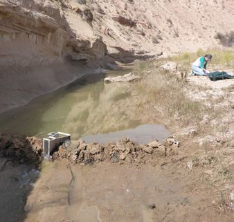
Cover. A, Unnamed Spring near Dennehotso, Arizona B, hydrologic technician collecting water-level
measurement from a windmill powered stock well, C, base-flow discharge measurement using a Parshall flume
at Dinnebito Wash near Sand Springs, Arizona streamflow gaging station, D, municipal well and storage tank at
Kits’illi, Arizona. Photographs by Jon Mason, U.S. Geological Survey.
Groundwater, Surface-Water, and Water-Chemistry Data, Black Mesa Area, Northeastern Arizona-2016-2018
Groundwater, Surface-Water, and Water-Chemistry Data,
Black Mesa Area, Northeastern Arizona—2016–2018

By Jon P. Mason

Prepared in cooperation with the Navajo Nation and Peabody Western Coal Company

Open-File Report 2021–1124

U.S. Department of the Interior
U.S. Geological Survey
Groundwater, Surface-Water, and Water-Chemistry Data, Black Mesa Area, Northeastern Arizona-2016-2018
U.S. Geological Survey, Reston, Virginia: 2021

For more information on the USGS—the Federal source for science about the Earth, its natural and living
resources, natural hazards, and the environment—visit https://www.usgs.gov or call 1–888–ASK–USGS.
For an overview of USGS information products, including maps, imagery, and publications,
visit https://store.usgs.gov.

Any use of trade, firm, or product names is for descriptive purposes only and does not imply endorsement by the
U.S. Government.

Although this information product, for the most part, is in the public domain, it also may contain copyrighted materials
as noted in the text. Permission to reproduce copyrighted items must be secured from the copyright owner.

Suggested citation:
Mason, J.P., 2021, Groundwater, surface-water, and water-chemistry data, Black Mesa area, northeastern
Arizona—2016–2018: U.S. Geological Survey Open-File Report 2021–1124, 50 p., https://doi.org/10.3133/
ofr20201124.

ISSN 2331-1258 (online)
Groundwater, Surface-Water, and Water-Chemistry Data, Black Mesa Area, Northeastern Arizona-2016-2018
iii

Contents
Abstract............................................................................................................................................................1
Introduction.....................................................................................................................................................1
     Purpose and Scope...............................................................................................................................6
     Previous Investigations........................................................................................................................7
Description of Study Area.............................................................................................................................9
     Physiography..........................................................................................................................................9
     Climate.....................................................................................................................................................9
     Geology..................................................................................................................................................11
           Geologic Units Below the N Aquifer........................................................................................11
           Geologic Units of the N Aquifer................................................................................................11
                    Moenave Formation..........................................................................................................11
                    Wingate Sandstone...........................................................................................................12
                    Kayenta Formation.............................................................................................................12
                    Navajo Sandstone.............................................................................................................12
                    Carmel Formation...............................................................................................................13
           Geologic Units of the D Aquifer................................................................................................13
                    Entrada Sandstone............................................................................................................13
                    Morrison Formation...........................................................................................................13
                    Dakota Sandstone.............................................................................................................13
                    Mancos Shale....................................................................................................................14
           Geologic Units of the T Aquifer................................................................................................14
                    Mesaverde Group..............................................................................................................14
                    Bidahochi Formation.........................................................................................................14
Hydrologic Data............................................................................................................................................14
     Withdrawals from the N Aquifer.......................................................................................................15
           Withdrawals in Calendar Years 2017 and 2018 Compared to Previous Years...................17
     Groundwater Levels in the N Aquifer...............................................................................................17
     Spring Discharge from the N Aquifer...............................................................................................26
     Surface-Water Discharge, Calendar Years 2017–18......................................................................31
           Moenkopi Wash..........................................................................................................................31
           Dinnebito Wash...........................................................................................................................31
           Polacca Wash.............................................................................................................................32
           Pasture Canyon Springs............................................................................................................33
           Surface-Water Base Flow.........................................................................................................33
     Water Chemistry..................................................................................................................................33
           Water-Chemistry Data for Wells Completed in the N Aquifer.............................................36
           Water-Chemistry Data for Springs that Discharge from the N Aquifer.............................36
           Water-Chemistry Data for Streams that Receive Flow from the N Aquifer......................36
Summary........................................................................................................................................................41
References Cited..........................................................................................................................................46
Groundwater, Surface-Water, and Water-Chemistry Data, Black Mesa Area, Northeastern Arizona-2016-2018
iv

     Figures
         1.   Map showing location of study area, Black Mesa area, northeastern Arizona.................3
         2.   Stratigraphic section showing rock formations and hydrogeologic units of the
              Black Mesa area, northeastern Arizona....................................................................................5
         3.   Aerial photograph of Organ Rock monocline and folding strata of Skeleton Mesa
              near Kayenta, Arizona...................................................................................................................9
         4.   Map showing mean annual precipitation, 1981-2010, Black Mesa area, Arizona............10
         5.   Aerial photograph of Moenave Formation outcropping on Garces Mesas,
              northeastern Arizona..................................................................................................................12
         6.   Annual withdrawals from the N aquifer, Black Mesa area, northeastern Arizona,
              1965–2018......................................................................................................................................17
         7.   Locations of well systems monitored for annual withdrawals from the N aquifer..........18
         8.   Map showing water-level changes in N-aquifer wells from the prestress
              period to 2018...............................................................................................................................19
         9.   Plots of observed water levels (1950–2018) in annual observation-well network,
              N aquifer........................................................................................................................................23
        10.   Plots of observed groundwater water-levels in continuous-record observation
              wells BM1–BM6 from 1963 to 2018 in the N aquifer..............................................................27
        11.   Map of surface-water and water-chemistry data-collection sites, N aquifer..................28
        12.   Plots of discharge from, Moenkopi School Spring, Burro Spring, Pasture Canyon
              Spring and Unnamed Spring near Dennehotso, N Aquifer...................................................29
        13.   Plots of daily mean discharge, calendar years 2017–2018 for Moenkopi Wash at
              Moenkopi, Dinnebito Wash near Sand Springs, Polacca Wash near Second Mesa,
              and Pasture Canyon Springs, Black Mesa area, northeastern Arizona.............................32
        14.   Plots of median winter flow for November, December, January, and February for
              water years 1977–2017 for Moenkopi Wash at Moenkopi, Dinnebito Wash near
              Sand Springs, Polacca Wash near Second Mesa and Pasture Canyon Springs,
              Black Mesa area, northeastern Arizona..................................................................................34
        15.   Map showing water chemistry and distribution of dissolved solids in the N aquifer,
              Black Mesa area..........................................................................................................................37
        16.   Plots of dissolved-solids concentrations for water samples from selected wells,
              N aquifer, Black Mesa area.......................................................................................................38
        17.   Plots of concentrations of dissolved solids, chloride, and sulfate for water samples
              from Moenkopi School Spring, Pasture Canyon Spring, Burro Spring, and Unnamed
              Spring near Dennehotso, which discharge from the N aquifer in Black Mesa area,
              northeastern Arizona..................................................................................................................43
v

Tables
    1.   Withdrawals from the N aquifer, Black Mesa area, northeastern Arizona,
         1965–2018........................................................................................................................................4
    2.   Tabulated list of progress reports for the Black Mesa monitoring program
         1978–2018........................................................................................................................................7
    3.   Identification numbers and names of monitoring program study wells, 2017–18,
         Black Mesa area, northeastern Arizona..................................................................................15
    4.   Withdrawals from the N aquifer by well system, Black Mesa area, northeastern
         Arizona, calendar years 2017 and 2018....................................................................................16
    5.   Total, industrial, and municipal withdrawals from the N aquifer for discrete time
         periods from 1965 to 2018, Black Mesa area, northeastern Arizona..................................17
    6.   Water-levels measured in monitoring program wells completed in the N aquifer
         during calendar years 2017 and 2018, and water level changes from the prestress
         period to calendar year 2018, Black Mesa area, northeastern Arizona.............................20
    7.   Well-construction characteristics, depth to top of N aquifer, and 2018 static water
         level for wells used in annual water-level measurements and for continuous-record
         observation wells, 2017–18, Black Mesa area, northeastern Arizona................................21
    8.   Median changes in water levels in monitoring-program wells from prestress
         period to 2018, N aquifer, Black Mesa area, northeastern Arizona....................................22
    9.    Discharge from Moenkopi School Spring, Burro Spring, Pasture Canyon Spring,
         and Unnamed Spring near Dennehotso, N Aquifer, Black Mesa area, northeastern
         Arizona, 1952–2018......................................................................................................................30
   10.   Streamflow-gaging stations used in the Black Mesa monitoring program, their
         periods of record, and drainage areas....................................................................................32
   11.   Comparison of chemical analyses of replicate and environmental water samples
         taken from Burro Spring, Black Mesa area, northeastern Arizona, 2017..........................35
   12.   Chemical analyses of a field blank water sample processed at Unnamed Spring
         near Dennehotso, Black Mesa area, northeastern Arizona, 2018.......................................35
   13.   Physical properties and chemical analyses of water samples from selected industrial
         and municipal wells completed in the N aquifer, Black Mesa area, northeastern
         Arizona, 2017.................................................................................................................................38
   14.   Specific conductance and concentrations of selected chemical constituents in
         water samples from selected industrial and municipal wells completed in the N
         aquifer, Black Mesa area, northeastern Arizona, during 1967–2017..................................39
   15.   Physical properties and chemical analyses of water samples from four springs in
         the Black Mesa area, northeastern Arizona, in 2017–2018..................................................40
   16.   Specific conductance and concentrations of selected chemical constituents in
         N aquifer water samples from four springs in the Black Mesa area, northeastern
         Arizona, 1948–2018......................................................................................................................41
   17.   Physical properties and chemical analyses of water samples from selected
         surface-water sites, Black Mesa area, northeastern Arizona, 2017..................................44
   18.   Total dissolved-solids concentrations at base flow from three stream in the Black
         Mesa area, northeastern Arizona, 1976–2017.........................................................................45
vi

     Conversion Factors
     U.S. customary units to International System of Units

                   Multiply                              By                           To obtain
                                                       Length
      inch (in.)                              2.54                       centimeter (cm)
      inch (in.)                             25.4                        millimeter (mm)
      foot (ft)                               0.3048                     meter (m)
      mile (mi)                               1.609                      kilometer (km)
                                                        Area
      square mile (mi2)                       2.590                      square kilometer (km2)
                                                       Volume
      acre-foot (acre-ft)                     0.001233                   cubic hectometer (hm3)
                                                      Flow rate
      cubic foot per second (ft3/s)           0.02832                    cubic meter per second (m3/s)
      gallon per minute (gal/min)             0.06309                    liter per second (L/s)
      gallon per year                         3.785                      liter per year (L/yr)

     Datum
     Vertical coordinate information is referenced to the National Geodetic Vertical Datum of 1929
     (NGVD 29).
     Horizontal coordinate information is referenced to the North American Datum of 1927 (NAD 27).
     Altitude, as used in this report, refers to distance above the vertical datum.

     Supplemental Information
     Specific conductance is given in microsiemens per centimeter at 25 degrees Celsius (µS/cm at
     25 °C).
     Concentrations of chemical constituents in water are given in either milligrams per liter (mg/L)
     or micrograms per liter (µg/L).
vii

Abbreviations
ADWR        Arizona Department of Water Resources
BIA         Bureau of Indian Affairs
C aquifer   Coconino aquifer
D aquifer   Dakota aquifer
EPA         U.S. Environmental Protection Agency
MCL         Maximum Contaminate Level
N aquifer   Navajo aquifer
NTUA        Navajo Tribal Utility Authority
NWIS        National Water Information System
NWQL        National Water Quality Laboratory
PWCC        Peabody Western Coal Company
QC          Quality control
SMCL        Secondary Maximum Contaminate Level
T aquifer   Toreva aquifer
USGS        United States Geological Survey
Groundwater, Surface-Water, and Water-Chemistry Data,
Black Mesa Area, Northeastern Arizona—2016–2018
By Jon P. Mason

Abstract                                                            and Unnamed Spring near Dennehotso. Discharge at Burro
                                                                    Spring has remained relatively constant since it was first mea-
      The Navajo (N) aquifer is the primary source of ground-       sured in the 1980s and discharge at Pasture Canyon Spring has
water in the 5,400-square-mile Black Mesa area in northeast-        fluctuated for the period of record.
ern Arizona. Availability of water is an important issue in the           Continuous records of surface-water discharge in the
Black Mesa area because of continued water requirements             Black Mesa area were collected from streamflow-gaging
for industrial and municipal use by a growing population and        stations at the following sites: Moenkopi Wash at Moen-
because of its arid climate. Precipitation in the area typi-        kopi 09401260 (1976 to 2018), Dinnebito Wash near Sand
cally ranges from less than 6 to more than 16 inches per year       Springs 09401110 (1993 to 2018), Polacca Wash near Second
depending on location.                                              Mesa 09400568 (1994 to 2018), and Pasture Canyon Springs
      The U.S. Geological Survey water-monitoring program in        09401265 (2004 to 2018). Median winter flows (November
the Black Mesa area began in 1971 and provides information          through February) of each water year were used as an index
about the long-term effects of groundwater withdrawals from         of the amount of groundwater discharge at the above-named
the N aquifer for industrial and municipal uses. This report        sites. For the period of record, the median winter flows have
presents results of data collected as part of the monitoring pro-   generally remained constant at Dinnebito Wash and Polacca
gram in the Black Mesa area from November 2016 to Decem-            Wash, whereas a decreasing trend was indicated at Moenkopi
ber 2018. The monitoring program includes measurements              Wash and Pasture Canyon Springs.
of (1) groundwater withdrawals (pumping), (2) groundwater                 In 2017 and 2018, water samples collected from two
levels, (3) spring discharge, (4) surface-water discharge, and      wells, four springs, and three streams in the Black Mesa area
(5) groundwater and surface-water chemistry.                        were analyzed for selected chemical constituents. The results
      In calendar year 2017, total groundwater withdrawals          from wells and springs were compared with previous analyses
were 3,710 acre-feet (acre-ft), industrial withdrawals were         from the same wells and springs. At the Peabody 2 well, a
1,110 acre-ft, and municipal withdrawals were 2,600 acre-ft.        significant (p0.05) at the Kykotsmovi PM2
municipal withdrawals were 2,500 acre-ft. Total withdrawals         well. Dissolved solids, chloride, and sulfate concentrations
during 2017 and 2018 were about 49 percent less than total          increased at Moenkopi School Spring during the more than
withdrawals in 2005 because of Peabody Western Coal Com-            30  years of record at that site. Concentrations of dissolved
pany’s discontinued use of water to transport coal in a coal        solids, chloride, and sulfate at Pasture Canyon Spring have not
slurry pipeline.                                                    varied significantly (p>0.05) since the early 1980s, and there is
      From the prestress period (prior to 1965) to 2018, mea-       no increasing or decreasing trend in those data. Concentrations
sured water levels available for comparison in wells completed      of dissolved solids, chloride, and sulfate at Burro Spring and
in the unconfined areas of the N aquifer within the Black Mesa      Unnamed Spring near Dennehotso have varied for the period
area declined in 8 of 14 wells, the changes ranged from +12.1       of record, but there is no statistical trend in the data. Baseflow
feet to −39.4 feet, and the median change was -0.6 feet. Water      water chemistry samples were collected from Moenkopi,
levels also declined in 15 of 18 wells measured in the confined     Dinnebito, and Polacca washes in 2017. Samples from all
area of the aquifer. The median change for the confined area        three washes had total-dissolved solids concentrations higher
of the aquifer was −40.2 feet (ft), with changes ranging from       than is typically found in the N aquifer water.
+14.2 ft to −189.0 ft. From the prestress period to 2018, the
median water-level change for all 32 wells in both the con-
fined and unconfined areas was −9.4 ft.
                                                                    Introduction
      Spring flow was measured at four springs in 2017 and               The 5,400-square-mile (mi2) Black Mesa study area is
2018. Flow fluctuated during the period of record for Burro         enclosed within the Navajo and Hopi Indian Reservations in
Spring and Pasture Canyon Spring, but a decreasing trend was        northeastern Arizona (fig. 1). It contains diverse topography
statistically significant (p
2   Groundwater, Surface-Water, and Water-Chemistry Data, Black Mesa Area, Northeastern Arizona—2016–2018                                                                                                                                                                                                                                                                                                                                                        Introduction  3

     111°30'                                                                      111°00’                                                                                   110°30'                   UTAH                                                110°00’                                                                                          109°30'
37°00’                                                                                                                                                                                               ARIZONA

                                                                                                                                                                                                             cline
                                                                                                           COCONINO COUNTY
                  Page

                                                                                                                             NAVAJO COUNTY
                                                                                                                                                                                                                     £
                                                                                                                                                                                                                     ¤                                                                                                                          Wa

                                                                                                                                                                                                          ono
                                                                                                                                                                                                                     163                                                           ge                                                             lke
                                                                                                                                                                                                                                                                        Rid
                                                                                                                                                                                                                                                                                                                                          £
                                                                                                                                                                                                                                                                                                                                          ¤          r

                                                                                                                                                                                                      k M
                                                                    Na                                                                                                                                                                                                                                                                    191
                                                                         v a jo         Cre                                                                                                                                                          Co mb                                 ek                                                               Cre
                                                                                            ek                                                                                                                                                                                         Cre                                                                          ek

                                                                                                                                                                                          a
                                                                                                                                                                                                                                                                                                        Dennehotso

                                                                                                                                                                                      Mes

                                                                                                                                                                                                   Roc
                                                         K                                                                                                                                                                                a
                                                                                                                                                                                                                                     Lagun                                                                                                                                                                  EXPLANATION
                                                          ab

                                                                                                                                                                                                   n
                                                                                                                                                                                      n

                                                                                                                                                                                               Orga
                                                                                                                                                                                 leto
                                                            ito

                                                                                                                                                                                                                                                                                                          k
                                                                                                                                                                                                         Kayenta

                                                                                                                                                                                                                                                                                                          ee
                                                                                                                                                                                                                                                                                                        Cr
                                                                                                                                                                                Ske
                                                                                                                                                                                                                                                                                                                                                                                               Area of Hopi Tribal Lands within Navajo Nation

                                                                                                                                                                                                                                                                       APACHE COUNTY
                                                                                                                                                                                                                                                       NAVAJO COUNTY
                                                                    Cr                                                                                                                                                                                                                             de
                                                                                                                                                                                                                                                                                                 en                                                                                            Boundary of Black Mesa
                                                                                                                                                                                                                                                                                            Ty
                                                                      eek
                                                                                                                             Shonto                                                  Tsegi
                                                                                                                             Plateau                                                                                                                                                                                                                                                           Boundary of study area—Based on the
                                                                                                                                                             Betatakin

                                                                                                                                                                                                                                                                                                                                                 Lu
                                                   98                                                                                                                                                                                                                                                                                                                                          mathematical boundary of groundwater model

                                                                                                                                                                                                                                                                                                                                                   ka
                                                                                                                                                                                                                                                                                                                                                     ch
                                                                                                                                                           Shonto                                                                                                                                                                                                                              from Brown and Eychaner (1988)

                                                                                                                                                                                                                                                                                                                                                       uk
                                                                                                                                                                                                                                                                                                                                                                    W

                                                                                                                                                                                                                                                                                                                                                         ai
                 Kaibito Plateau                                                                                                                                           lley                                                                                                                                                                                          h
                                                                                                                                                                        Va                                             COAL-LEASE

                                                                                                                                                                                                                                                                                                                                                                    as
                                                                                                                                                                   se
                                                                                                                                                                ou                                                     AREA
                                                                                                                                                             H
                                                                                                                                                        ng                                                                      Chilchinbito
36°30'                                                                                                                                                Lo
                                                                                                                                                      Shonto Junction                                                                                                                                   Rough Rock

                                                                                                                                                                                   sh

                                                                                                                                                                                                                                                                                                                   Chinle Valley
                                                                                                                                                                                 Wa

                                                                                                                                                                                                                                                                                                                                                 Chinle
                                                                                                                                                               i                                                                           Kitsillie
                                                                                                                                                             op
                                                                                  Red Lake                                                              oenk
                                                                                                                                                       M

                                                                                                                                                                                                 h
                                                                                                                                                                                                                                                                                                                                                                                                                                  Map area

                                                                                                                                                                                              Was
                                                                                                                                                                                                         Forest Lake
                                                                                  £
                                                                                  ¤

                                                                                                                                                                                                                                                                                                                                                  Wash
                                                                                  160
                                                                                                                                                                                                                           s                                                                                                                                                                                                    Hopi Black Mesa
                                                                                                                                                                                                                        Wa

                                                                                                                                                                                                                         h
                                                                                                                                                                                                                                                                                                                                                                                                                               Tribal
                                                                                                                                                                                                                                                                                                                                                                                                             iver
                                                                                                                                                                                                                                                                                                                                                                                                           oR                  Lands

                                                                                                                                                                                          bito
                                                                                                                                                                                                                i                                                                                                                                                                                     ad
                                                                                                                                                                                                             aib                                                                                                                                                                                   lor
                                                                                                                                                                                      ne                  Or                                                                                                                                               Chinle

                                                                                                                                                                                                                                                                                                                                                                                               Co
                                                                                                                                                                                     in
                                                  Rare Metals                                                                                                                         D

                            Tuba City                                                                                                                                                                                      Pinõn

                                                                                                                                                                                                                                                                                                                                                          Nazlini
                                                                                                                                                                                                                                                                                                                                                                                                               Flagstaff                Navajo Nation
                                                          Moenkopi                                                                                              Rocky Ridge                        Hard Rock
                                                                                                                                                                                                                                                                                                                 ood                Wash                                                                                   !            Litt
                                                                                                                                                                                                                                                                                                         Cotton w                                                                                                                            le C
                                                                                                                                                                                                                                                                                                                                                                                                                                                 olo
                                                                                                                                                                                                                                                                                                                                                                                                                                                     rad

                                                                                                                                                                                                                                                                                                                                                            Wash
                                                                                                                                                                                                                                             s   h                                                                                                                                                          A R I Z O N A

                                                                                                                                                                                                                                                                                                                                                                                                                                                       oR
                                                                                                                                                                                                                                          Wa

                                                                                                                                                                                                                                                                                                                                                                                                                                                         iver
36°00’                                                                                                                                                          Hopi                  Mesas
                                                                                                                                                                                                                                               Low
                                                                                                                                                                                                                               ca
                                                                    Moenkopi            264
                                                                                                                                                                                                                           ac   l                                                                                                                                                                                                      Salt Rive

                                                                                                                                                                                                                                                                                  Ba
                                                                                                                                                                                                                                              Mountain
                                                                                                                                                                                                                           Po

                                                                                                                                                                                                                                                                                                                                                                                       iver
                                                                                                                                                                                              a

                                                                     Plateau

                                                                                                                                                                                                                                                                                       la
                                                                                                                                                                                           es

                                                                                                                                                                                                                                                                                                                                                                                                                                                   r

                                                                                                                                                                                                                                                                                        ka
                                                                                                                                                       Bacavi
                                                                                                                                                                                                                   a
                                                                                                                                                                                          M

                                                                                                                                                                                                                                                 on                                                                                         £
                                                                                                                                                                                                                                                                                                                                            ¤
                                                                                                                                                                                                                es

                                                                                                                                                                                                                                                                                                                                                                                                            Phoenix

                                                                                                                                                                                                                                                                                                                                                                             Colorado R
                                                                                                                                                                                                                                                                                          i
                                                                                                                                                                                                                                                                                                                                            191
                                                                                                                   Hotevilla                                                                                                                  ny
                                                                                                                                                                                                             M
                                                                                                                                                                                     nd

                                                                                                                                                                                                                                                                                                                                                                                                                    !

                                                                                                                                                                                                                                                                                             M
                                                                                                                                                                                                                                           Ca
                                                                                                                                                                                co

                                                                                                                                                                                                                                                                                                                                                                                                                        G i la River

                                                                                                                                                                                                                                                                                                  es
                                                                                                                                                                                                        st
                                                                                                                                 a

                                                                                                                                                                                                                                         s
                                                                                                                              es

                                                                                                                                                                                                                                                h
                                                                                                                                                                            Se

                                                                                                                                                                                                     Fir

                                                                                                                                                                                                                                                                                                    a
                         Cameron
                                                                                                                                                                                                                                       am Was
                                                                                                                             M

                                                                                                                                                                                                     Polacca
                                                                                                                                                                                Shipaulovi                                          Ke
                                                                                                                ird

                                                                                                                                   Kykotsmovi                                                                                                                                                                                                                                         !
                              Li

                                                                                                           Th

                                                                                                                                                                                                                                                                                                                                                                                        Yuma
                                ttle

                                                  Wa

                                                                                                                                                                                          Mishongnovi                 Keams
                                                                                                                                                      Shungopavi
               £
               ¤                                                                                                                                                                                                     Canyon
                                                     rd

               89                                                                                                                                                                                                                                                                                                                                                                                                          Tucson
                                                                                                                                                                                                                                                                                                                                                                                                                                  !
                                                                                                                                                       Second Mesa                                                                                                                                                264
                                   Colorado

                                                        Te
                                                           rra

                                                                                                                                                                                                                                                                                                                                                          Ganado
                                                               ce

                                                                                                                                                                                                                                                                                                                                     sh
                                                                                                                                                                                                            h

                                                                                                                                                                                                                                                                                                                                   Wa
                                                                                                                                                                                     87
                                                                                                                                                                                                     s
                                                                                                                                                                                                   Wa
                                       Ri v e r

                                                                                                       s
                                                                                                       a
                                                                                                    es

                                                                                                                                                                                                                                                                                                                       o
                                                                                                                                                                                                                                                      77
                                                                                                   M

                                                                                                                                                                                                                                                                                                                  ad
                                                                                                                                                                                                                                                                                                                   o   r
                                                                                                                                                                                                                                                                                                               Col
                                                                                                s
                                                                                              ce

                                                                                                                                                                               ito

                                                                                                                                                                                              Hopi Buttes
                                                                                               r
                                                                                            Ga

                                                                                                                                                                             dd

                                                                                                                                                                                Je
                                                                                                                                                                                                                                                                                                      blo

                                                                                                                                                                                                                                                                                                                                                                             Figure 1. Map showing location of study area, Black Mesa area, northeastern Arizona. Boundary
                                                                                                                                                                                                                                                                                                   Pue

35°30'                                                                                                                                                                                                                                                                                                                                                                       of study area is based on boundary of groundwater model from Eychaner, 1983.
         Base from U.S. Geological Survey digital data, 2010                                                   0                             5               10                 15            20           25 MILES                                                                                              Modified from Brown and Eychaner, 1988
         Lambert Conformal Conic projection
         Standard parallels 29°30’ N. and 45°30’ N.,                                                           0                 5               10        15          20       25 KILOMETERS
         central meridian -111°30’ W.
4   Groundwater, Surface-Water, and Water-Chemistry Data, Black Mesa Area, Northeastern Arizona—2016–2018

Black Mesa, a topographic high at the center of the study area,      northeastern part of the study area where it would be deeply
encompasses about 2,000 mi2. It has 2,000-foot-high cliffs           buried. The N aquifer is confined under most of Black Mesa,
on its northern and northeastern sides, but it slopes gradually      and the overlying stratigraphy limits recharge to this part of
down to the south and southwest. Availability of water is            the aquifer. The N aquifer is unconfined in areas surround-
an important issue in the study area because of continued            ing Black Mesa, and most recharge occurs where the Navajo
groundwater withdrawals, the growing population, and an arid         Sandstone is exposed in the area near Shonto (fig. 1) (Lopes
to semiarid climate.                                                 and Hoffmann, 1997). From the recharge areas near Shonto,
      Aquifers that are utilized in the Black Mesa area include      groundwater moves radially southwest toward Tuba City,
the Toreva (T), Dakota (D), and Navajo (N) aquifers (fig. 2).        south toward the Hopi Reservation, and east toward Rough
Shallow aquifers composed of surficial sediments or volca-           Rock and Dennehotso (Eychaner, 1983).
nic rock are used locally to supply small quantities of water.             Within the Black Mesa study area, the Navajo Nation
The N aquifer is the major source of water for industrial            and Hopi Tribe are the principal municipal water users, and
and municipal uses in the Black Mesa area. For this reason,          PWCC is the principal industrial water user. Withdrawals from
groundwater data collected for this report was exclusively           the N aquifer in the Black Mesa area increased fairly consis-
from the N aquifer. Water from the T and D aquifers are not          tently from 1965 through 2005 and then decreased markedly
used in substantial quantities in the Black Mesa area. Water         in 2006 (table 1). PWCC began operating a strip mine in the
from the T aquifer is used locally for livestock watering and        northern part of the study area in 1968 (highlighted red in
to irrigate small plots of land, but it likely cannot produce        fig. 1). PWCC’s mining operation consisted of two mines on
enough water for municipal or industrial use. Water from the         Black Mesa—the Kayenta mine, which transported coal to the
D aquifer is used locally for livestock watering and has con-        Navajo Generating Station by train, and the Black Mesa mine,
tributed to some wells at the Peabody Western Coal Company           which transported coal 275 miles to the Mohave Generating
(PWCC) well field, but water from the aquifer has elevated           Station by a water-based coal slurry pipeline.
total-dissolved solids concentrations that make it unsuitable              PWCC operated both mines on Black Mesa from the
for municipal use. The deeper Coconino (C) aquifer is present        1970s until about 2005, when the Mohave Generating Station
throughout the Black Mesa area, but it is deeply buried and          ceased operations. On December 31, 2005, PWCC reduced
likely has total-dissolved solids concentrations above what can      pumping of the N aquifer by approximately 70 percent as
be used without treatment.                                           a result of discontinued use of the coal slurry pipeline that
      According to Eychaner (1983) the N aquifer is composed         delivered water, in addition to coal, to the Mohave Generating
of three hydraulically connected formations—the Navajo               Station. The two mines at PWCC have since been combined
Sandstone, Kayenta Formation, and Wingate Sandstone—that             into the Black Mesa Complex, which still delivers coal to the
function as a single aquifer (fig. 2). However, more recent          Navajo Generating Station by an electric train. PWCC contin-
geologic mapping indicates the Wingate Sandstone is absent           ued to pump about 1,100 to 1,600 acre-feet (acre-ft) per year
from much of the Black Mesa area. Outcrops of sandstone              after 2005, primarily for dust control (table 1).
previously mapped as Wingate Sandstone in the Black Mesa                   There are four major stream systems that provide surface
area are now considered to be part of the Moenave Formation          drainage for the Black Mesa area. They are Moenkopi Wash,
(Billingsley and others, 2012, 2013). Based on this recent geo-      Dinnebito Wash, Oraibi Wash, and Polacca Wash. All four
logic mapping it is unclear if the Wingate Sandstone is present      stream systems have headwaters high on Black Mesa and
at all in the Black Mesa area. If present it would only be in the    eventually drain into the Little Colorado River to the south

Table 1. Withdrawals from the N aquifer, Black Mesa area, northeastern Arizona, 1965–2018.

              Industriala          Municipalb,c                                   Industriala           Municipalb,c
  Calendar                                                 Total       Calendar                                                 Total
    Year                                               withdrawals       Year                                               withdrawals
                            Confined      Unconfined                                            Confined       Unconfined
1965               0          50              20          70         1975          3,500         600             510        4,610
1966               0         110              30         140         1976          4,180         690             640        5,510
1967               0         120              50         170         1977          4,090         750             730        5,570
1968            100          150            100          350         1978          3,000         830             930        4,760
1969             40          200            100          340         1979          3,500         860             930        5,290
1970            740          280            150        1,170         1980          3,540         910             880        5,330
1971          1,900          340            150        2,390         1981          4,010         960            1,000       5,970
1972          3,680          370            250        4,300         1982          4,740         870             960        6,570
1973          3,520          530            300        4,350         1983          4,460        1,360           1,280       7,100
1974          3,830          580            360        4,770         1984          4,170        1,070           1,400       6,640
Introduction  5

                                                   Water bearing in places

                                                                                                                                                                    QUATERNARY
                             Volcanic rock   ►

                                                                                                                                                                     TERTIARY
 Bidahochi

                                                                                                                                                       TERTIARY
                             Volcanic rock   ►
 Formation

                                                                                                                                                                       and
                Yale Point Sandstone

 Mesa           Wepo Formation                                                                                  EXPLANATION
 Verde                                                                           T aquifer                             Water bearing
 Group

                                                                                                                                                       CRETACEOUS
                Toreva Sandstone

 Mancos Shale

 Dakota Sandstone

 Morrison
 Formation

                                                                                                D aquifer

 San Rafael     Entrada Sandstone
 Group

                                                                                                                                                        JURASSIC
               Carmel Formation

                Navajo Sandstone
 Glen
 Canyon                                                                                                              N aquifer
 Group
               Kayenta Formation

                Moenave       Wingate
                Formation     Sandstone?                                             ???1                ?1

 Chinle Formation
                                                                                                                                                       TRIASSIC

                                                                             Shinarump Member
 Moenkopi Formation
 Kaibab Limestone

 Coconino Sandstone                                                                                                                        C Aquifer
                                                                                                                                                       PERMIAN

 Supai Formation or Group

1
  Unclear if present, some outcrops formerly mapped as Wingate Sandstone are now                  Modified from Harshberger and others, 1966
considered part of Moenave Formation (Billingsley and others, 2012, 2013).

Figure 2. Stratigraphic section showing rock formations and hydrogeologic units of the Black Mesa area,
northeastern Arizona (not to scale). The N aquifer is approximately 1,000 feet thick.

men20-2166_fig02
6   Groundwater, Surface-Water, and Water-Chemistry Data, Black Mesa Area, Northeastern Arizona—2016–2018

Table 1.—Continued

                   Industriala             Municipalb,c                                            Industriala                Municipalb,c
  Calendar                                                          Total        Calendar                                                             Total
    Year                                                        withdrawals        Year                                                           withdrawals
                                   Confined       Unconfined                                                           Confined      Unconfined
 1985               2,520          1,040           1,160         4,720          2002                4,640           1,500             1,860           8,000
 1986               4,480            970           1,260         6,710          2003                4,450             1,350           1,440           7,240
 1987               3,830          1,130           1,280         6,240          2004                4,370             1,240           1,600           7,210
 1988               4,090          1,250           1,310         6,650          2005                4,480             1,280           1,570           7,330
 1989               3,450          1,070           1,400         5,920          2006                1,200         d
                                                                                                                      1,300          d
                                                                                                                                      1,600       d
                                                                                                                                                      4,100
 1990               3,430          1,170           1,210         5,810          2007                1,170             1,460           1,640           4,270
 1991               4,020          1,140           1,300         6,460          2008                1,210         e,f
                                                                                                                       1,430         e
                                                                                                                                      1,560       f
                                                                                                                                                      4,200
 1992               3,820          1,180           1,410         6,410          2009                1,390             1,440           1,400           4,230
 1993               3,700          1,250           1,570         6,520          2010                1,170         d
                                                                                                                      1,450           1,420       d
                                                                                                                                                      4,040
 1994               4,080          1,210           1,600         6,890          2011                1,390          d
                                                                                                                       1,460          1,630       d
                                                                                                                                                      4,480
 1995               4,340          1,220           1,510         7,070          2012                1,370          d
                                                                                                                       1,380          1,260       d
                                                                                                                                                      4,010
 1996               4,010          1,380           1,650         7,040          2013                1,460         d
                                                                                                                      1,410          d
                                                                                                                                         1,110    d
                                                                                                                                                      3,980
 1997               4,130          1,380           1,580         7,090          2014                1,580         d
                                                                                                                      1,280          d
                                                                                                                                      1,310       d
                                                                                                                                                      4,170
 1998               4,030          1,440           1,590         7,060          2015                1,340         d
                                                                                                                      1,370          d
                                                                                                                                      1,260       d
                                                                                                                                                      3,970
 1999               4,210          1,420           1,480         7,110          2016                1,090         d
                                                                                                                      1,380          d
                                                                                                                                      1,070       d
                                                                                                                                                      3,540
 2000               4,490          1,610           1,640         7,740          2017                1,110             1,330          d
                                                                                                                                      1,270       d
                                                                                                                                                      3,710
 2001               4,530          1,490           1,660         7,680          2018                1,170         d
                                                                                                                      1,370           1,130       d
                                                                                                                                                      3,670

  Metered pumpage from the confined part of the aquifer by Peabody
  a
                                                                               Geological Survey, 1980–85; and metered pumpage furnished by the Navajo
Western Coal Company.                                                          Tribal Utility Authority, the Bureau of Indian Affairs, various Hopi Village
                                                                               Administrations, and the U.S. Geological Survey, 1986–2018.
  b
      Does not include withdrawals from the wells equipped with windmills.
                                                                                  d
                                                                                    Meter data were incomplete; therefore, municipal withdrawals are
  c
    Includes estimated pumpage 1965–73 and metered pumpage 1974–79
                                                                               estmated, and total withdrawal uses an estimation in the calculation.
at Tuba City; metered pumpage at Kayenta and estimated pumpage at
Chilchinbito, Rough Rock, Piñon, Keams Canyon, and Kykotsmovi before             e
                                                                                     Confined and unconfined totals were reversed in previous reports.
1980; metered and estimated pumpage furnished by the Navajo Tribal Utility       f
                                                                                     Confined withdrawals are about 90 acre-ft greater than previously reported.
Authority and the Bureau of Indian Affairs and collected by the U.S.
Geological Survey, 1980–85; and metered pumpage furnished by the Navajo
Tribal Utility Authority, the Bureau of Indian Affairs, various Hopi Village
Administrations, and the U.S. Geological Survey, 1986–2011.

and southwest of the study area (fig. 1). Most reaches of these                Purpose and Scope
streams are ephemeral, flowing only in response to runoff from
precipitation events, but a few short reaches flow at least part                    This report presents results of groundwater, surface-
of each year as a result of groundwater discharge.                             water, and water-chemistry monitoring in the Black Mesa
      The members of the Navajo Nation and the Hopi  Tribe                     area from November 2016 to December 2018. Continuous
have been concerned about the long-term effects of withdraw-                   and periodic groundwater and surface-water data are collected
als from the N aquifer on available groundwater  supplies, on                  to monitor the possible effects of industrial and municipal
stream and spring discharge, and on groundwater  chemistry.                    withdrawals from the N aquifer on groundwater levels, stream
In 1971, these water-supply concerns led to the establishment                  and spring discharge, and groundwater chemistry. Groundwa-
of a monitoring program for the water resources in the  Black                  ter data include groundwater withdrawals (pumping), water
Mesa area by the U.S. Geological Survey (USGS) in coop-                        levels, spring-discharge rates, and water chemistry. Surface-
eration with the Arizona Water Commission, which was the                       water data include discharge rates at four continuous-record
predecessor to the present Arizona Department of Water                         streamflow-gaging stations and water chemistry from three
Resources (ADWR). In 1983, the Bureau of Indian Affairs                        of the gaging stations. Together, these data are compared
(BIA) joined the cooperative effort. Since 1983, the Navajo                    with groundwater and surface-water data from 1965 to 2018
Tribal Utility Authority (NTUA), the PWCC, the Hopi Tribe,                     to describe the overall status of and change over time of
and the Western Navajo, Chinle, and Hopi Agencies of the                       groundwater conditions in the N aquifer, as well as to pro-
BIA have assisted in the collection of hydrologic data.                        vide information on how the aquifer responds to groundwater
Introduction  7

development stresses. Some statistical analyses of the data                   Stream-discharge and periodic water-quality data
are included in this report to examine trends in the data that           collected from Moenkopi Wash before the 1982 water year
characterize groundwater conditions in the N aquifer.                    were published by the USGS (1963–64a,b; 1965–74a,b; and
                                                                         1976–83). Stream-discharge data from water years 1983 to
Previous Investigations                                                  2005 for Moenkopi Wash at Moenkopi (09401260), Dinnebito
                                                                         Wash near Sand Springs (09401110), Polacca Wash near
     Progress reports on the Black Mesa area monitoring                  Second Mesa (09400568), Laguna Creek at Dennehotso
program have been prepared by the USGS since 1978,  and                  (09379180), and Pasture Canyon Spring (09401265) in the
these progress reports are summarized in table 2. The                    Black Mesa area were published in White and Garrett (1984,
groundwater-level, surface-water discharge, and water                    1986, 1987, 1988), Wilson and Garrett (1988, 1989), Boner
chemistry data from the Black Mesa area monitoring program               and others (1989, 1990, 1991, 1992), Smith and others (1993,
are contained in these progress reports and in the USGS                  1994, 1995, 1996, 1997), Tadayon and others (1998, 1999,
National Water Information System (NWIS) database (http://               2000, 2001), McCormack and others (2002, 2003), Fisk
waterdata.usgs.gov/az/nwis/). Water-withdrawal data are                  and others (2004, 2005, 2006), and online for year 2006 to
presented in tables in the progress reports.                             present (http://wdr.water.usgs.gov). Before the monitoring

Table 2. Tabulated list of progress reports for the Black Mesa monitoring program 1978–2018.

 Year published                Author(s)                                     Title                         USGS report type and number
                                                    Progress report on Black Mesa monitoring
  1978            U.S. Geological Survey                                                                  Open-File Report 78–459
                                                      program—1977
                                                    Progress report on Black Mesa monitoring
  1985            Hill, G.W.                                                                              Open-File Report 85-483
                                                      program—1984
                                                    Progress report on Black Mesa monitoring
  1986            Hill, G.W., and Whetten, M.I.                                                           Open-File Report 86-414
                                                      program—1985–86
                                                    Progress report on the ground-water, surface-water,
  1987            Hill, G.W., and Sottilare, J.P.     and quality-of-water monitoring program, Black      Open-File Report 87–458
                                                      Mesa area, northeastern Arizona—1987
                                                    Progress report on the ground-water, surface-water,
  1988            Hart, R.J., and Sottilare, J.P.     and quality-of-water monitoring program, Black      Open-File Report 88–467
                                                      Mesa area, northeastern Arizona—1987–88
                                                    Progress report on the ground-water, surface-water,
  1989            Hart, R.J., and Sottilare, J.P.     and quality-of-water monitoring program, Black      Open-File Report 89–383
                                                      Mesa area, northeastern Arizona—1988–89
                                                    Results of ground-water, surface-water, and water-
                                                                                                          Water-Resources Investigations
  1992            Sottilare, J.P.                     quality monitoring, Black Mesa area, northeastern
                                                                                                           Report 92–4008
                                                      Arizona—1989–90
                                                    Results of ground-water, surface-water, and water-
                                                                                                          Water-Resources Investigations
  1992            Littin, G.R.                        quality monitoring, Black Mesa area, northeastern
                                                                                                           Report 92–4045
                                                      Arizona—1990–91
                                                    Results of ground-water, surface-water, and water-
                                                                                                          Water-Resources Investigations
  1993            Littin, G.R.                        quality monitoring, Black Mesa area, northeastern
                                                                                                           Report 93–4111
                                                      Arizona—1991–92
                                                    Results of ground-water, surface-water, and water-
                                                                                                          Water-Resources Investigations
  1995            Littin, G.R., and Monroe, S.A.      quality monitoring, Black Mesa area, northeastern
                                                                                                           Report 95–4156
                                                      Arizona—1992–93
                                                    Results of ground-water, surface-water, and water-
                                                                                                          Water-Resources Investigations
  1995            Littin, G.R., and Monroe, S.A.      chemistry monitoring, Black Mesa area, northeast-
                                                                                                           Report 95–4238
                                                      ern Arizona—1994
                                                    Ground-water, surface-water, and water-chemistry
  1996            Littin, G.R., and Monroe, S.A.                                                          Open-File Report 96–616
                                                      data, Black Mesa area, northeastern Arizona—1995
                                                    Ground-water, surface-water, and water-chemistry
  1997            Littin, G.R., and Monroe, S.A.                                                          Open-File Report 97–566
                                                      data, Black Mesa area, northeastern Arizona—1996
8   Groundwater, Surface-Water, and Water-Chemistry Data, Black Mesa Area, Northeastern Arizona—2016–2018

Table 2.—Continued

 Year published                Author(s)                                    Title                         USGS report type and number

                  Littin, G.R., Baum, B.M., and     Ground-water, surface-water, and water-chemistry
  1999                                                                                                   Open-File Report 98–653
                    Truini, Margot                    data, Black Mesa area, northeastern Arizona—1997
                  Truini, Margot, Baum, B.M.,
                                                    Ground-water, surface-water, and water-chemistry
  2000              Littin, G.R., and Shingoite-                                                         Open-File Report 00–66
                                                      data, Black Mesa area, northeastern Arizona—1998
                    wa-Honanie, Gayl
                  Thomas, B.E., and Truini,         Ground-water, surface-water, and water-chemistry
  2000                                                                                                   Open-File Report 00–453
                    Margot                            data, Black Mesa area, northeastern Arizona–1999
                                                    Ground-water, surface-water, and water-chemistry
                                                      data, Black Mesa area, northeastern Arizo-       Water-Resources Investigations
  2002a           Thomas, B.E.
                                                      na—2000–2001, and performance and sensitivity of  Report 02–4211
                                                      the 1988 USGS numerical model of the N aquifer
                                                    Ground-water, surface-water, and water-chemistry
  2002b           Thomas, B.E.                        data, Black Mesa area, northeastern Arizo-         Open-File Report 02–485
                                                      na—2001–02
                                                    Ground-water, surface-water, and water-chemistry
                  Truini, Margot, and Thomas,
  2004                                                data, Black Mesa area, northeastern Arizo-         Open-File Report 03–503
                    B.E.
                                                      na—2002–03
                                                    Ground-water, surface-water, and water-chemistry
                  Truini, Margot, Macy, J.P., and
  2005                                                data, Black Mesa area, northeastern Arizo-         Open-File Report 2005–1080
                    Porter, T.J.
                                                      na—2003–04
                                                    Ground-water, surface-water, and water-chemistry
  2006            Truini, Margot, and Macy, J.P.      data, Black Mesa area, northeastern Arizo-         Open-File Report 2006–1058
                                                      na—2004–05
                                                    Ground-water, surface-water, and water-chemistry
  2007            Truini, Margot, and Macy, J.P.      data, Black Mesa area, northeastern Arizo-         Open-File Report 2007–1041
                                                      na—2005–06
                                                    Ground-water, surface-water, and water-chemistry
  2008            Truini, Margot, and Macy, J.P.      data, Black Mesa area, northeastern Arizo-         Open-File Report 2008–1324
                                                      na—2006–07
                                                    Groundwater, surface-water, and water-chemistry data,
  2009            Macy, J.P.                                                                              Open-File Report 2009–1148
                                                      Black Mesa area, northeastern Arizona—2007–2008

                                                    Groundwater, surface-water, and water-chemistry data,
  2010            Macy, J.P.                                                                              Open-File Report 2010–1038
                                                      Black Mesa area, northeastern Arizona—2008–2009

                                                    Groundwater, surface-water, and water-chemistry data,
  2011            Macy, J.P., and Brown, C.R.                                                             Open-File Report 2011-1198
                                                      Black Mesa area, northeastern Arizona—2009–2010

                  Macy, J.P., Brown, C.R., and      Groundwater, surface-water, and water-chemistry data,
  2012                                                                                                    Open-File Report 2012-1102
                   Anderson, J.R.                     Black Mesa area, northeastern Arizona—2010–2011

                                                    Groundwater, surface-water, and water-chemistry data,
  2014            Macy, J.P., and Unema, J.A.                                                             Open-File Report 2013-1304
                                                      Black Mesa area, northeastern Arizona—2011–2012

                                                    Groundwater, surface-water, and water-chemistry data,
  2015            Macy, J.P. and Truini, Margot                                                           Open-File Report 2015-1221
                                                      Black Mesa area, northeastern Arizona—2012–2013

                                                    Groundwater, surface-water, and water-chemistry data,
  2017            Macy, J.P., and Mason, J.P.                                                             Open-File Report 2017-1127
                                                      Black Mesa area, northeastern Arizona—2013–2015

                                                    Groundwater, surface-water, and water-chemistry data,
  2018            Mason, J.P., and Macy, J.P.                                                             Open-File Report 2018-1193
                                                      Black Mesa area, northeastern Arizona—2015–2016
Description of Study Area   9

program, a large data-collection effort in the 1950s resulted in   below sea level now rise over 8,000 feet above sea level. As
a compilation of well and spring data for the Navajo and Hopi      a result of this uplift, the region has gone from a depositional
Indian Reservations (Davis and others, 1963).                      cycle to an erosional cycle. Much of the erosion responsible for
      Many interpretive studies have investigated the hydrology    present day topography likely occurred in the past 10 million
of the Black Mesa area. Cooley and others (1969) made the          years (Lazear and others, 2013). Since uplift occurred, Black
first comprehensive evaluation of the regional hydrogeology        Mesa has been dissected by streams, resulting in the formation
of the Black Mesa area. Eychaner (1983) developed a two-           of numerous smaller mesas such as the Hopi Mesas.
dimensional numerical model of groundwater flow  in the N                The geologic units that comprise the N aquifer occur at or
aquifer. Brown and Eychaner (1988) recalibrated Eychaner’s         near the land surface in a large extent around the periphery of
model by using a finer grid and by using revised estimates         Black Mesa. In these areas the aquifer is generally unconfined.
of selected aquifer characteristics. GeoTrans, Inc. (1987)         West of Kayenta, exposed N aquifer units form Skeleton Mesa
also developed a two-dimensional numerical model of the N          and the Shonto Plateau. At the southeast edges of these features,
aquifer in the 1980s. In the late 1990s, HSIGeoTrans, Inc. and     the aquifer units are folded by the Organ Rock monocline
Waterstone Environmental Hydrology and Engineering (1999)          (fig. 3) and plunge steeply to the southeast below the younger
developed a three-dimensional numerical model of the N             Cretaceous rocks of Black Mesa forming Long House Valley.
aquifer and the overlying D aquifer.                               The N aquifer units continue to the southeast under Black Mesa
      Kister and Hatchett (1963) made the first comprehensive      eventually reappearing south of the Hopi Mesas. The aquifer
evaluation of the chemistry of water collected from wells          units pinch out not far from where they reappear. In general, the
and springs in the Black Mesa area. HSIGeoTrans, Inc.              confined portion of the N aquifer occurs where the aquifer units
(1993) evaluated the major-ion and isotopic chemistry of           are deeply buried beneath Black Mesa.
the D and N aquifers. Lopes and Hoffmann (1997) analyzed                 The paths of stream channels also are influenced by
groundwater ages, recharge, and hydraulic conductivity of          physiography. Geologic structural folds, joint patterns, rock
the N aquifer by using geochemical techniques. Zhu and             type, and topography all affect the flow of surface water in
others (1998) estimated groundwater recharge in the Black          the study area. Major streams of the study area are shown
Mesa area by using isotopic data and flow estimates from the       in figure  1. The surface topography of Black Mesa slopes
N-aquifer model developed by GeoTrans, Inc. (1987). Zhu            downhill from northeast to southwest. Likewise, the major
(2000) estimated recharge using advective transport modeling       streams that drain Black Mesa flow from northeast to
and the same isotopic data from the GeoTrans model. Truini         southwest toward the Little Colorado River.
and Longsworth (2003) described the hydrogeology of the
D aquifer and the movement and ages of groundwater in the          Climate
Black Mesa area by using data from geochemical and isotopic
analyses. Truini and Macy (2005) looked at possible leakage             The climate in most of the Black Mesa area is
through the confining unit between the D aquifer and the N         broadly classified by Hendricks (1985) as steppe, which is
aquifer as part of an investigation of the Carmel Formation.       characterized by limited amounts of precipitation. Much of the
                                                                   precipitation in steppe regions evaporate before it can infiltrate
                                                                   to groundwater. As a result, the vegetation cover consists
Description of Study Area
     The availability and chemistry of water resources within
the Black Mesa area are directly related to physiography,
climate, and geology. Physiography affects the movement of
both surface water and groundwater in the area, and climate
affects the water budget. The complex geologic history of
the area has resulted in the accumulation of abundant coal
resources and influences the movement and chemistry of
surface water and groundwater.

Physiography
      The Black Mesa area is in the Colorado Plateau Physio-
graphic Province of the Rocky Mountain Region (Raisz, 1972).
The dominant physiographic feature in the study area is Black
Mesa itself, but numerous smaller features play an important       Figure 3. Aerial photograph of Organ Rock monocline and
role in the movement of surface water and groundwater (fig.  1).   folding strata of Skeleton Mesa near Kayenta, Arizona. The Navajo
Black Mesa is the remnant of a large sedimentary basin that has    Sandstone is truncated in this part of the monocline, forming the
undergone substantial tectonic deformation and uplift during       flatirons along the lower part of the monocline. Photograph by
the past 70 million years. Parts of Black Mesa which were once     Jodi Norris.
10   Groundwater, Surface-Water, and Water-Chemistry Data, Black Mesa Area, Northeastern Arizona—2016–2018

mostly of mesquite, pinyon-juniper, and various grasses                                                                                   precipitation data from traditional weather stations and high-
(Hendricks, 1985). A small area around Tuba City is classified                                                                            altitude meteorological sites (Daly and others, 1994). Based
by Hendricks (1985) as desert, signifying even less annual                                                                                on 30-year averages from 1981–2010, annual precipitation in
rainfall and a vegetative cover consisting mostly of creosote                                                                             the Black Mesa area ranges from less than 6 inches (in) in the
bush, cacti, and sagebrush.                                                                                                               lower elevation regions around the mesa to more than 16 in
     Mean annual precipitation for the Black Mesa area was                                                                                at the highest elevations on the mesa (fig. 4; PRISM Climate
estimated using spatial regression methods that incorporated                                                                              Group, 2018).

           111°30'                                            111°00’                                                                    110°30'             UTAH                                  110°00’                                                                      109°30'
       37°00’                                                                                                                                               ARIZONA

                                                                                       COCONINO COUNTY

                                                                                                         NAVAJO COUNTY
                      Page                                                                                                                                                                                                                                           Wa
                                                                                                                                                                         £
                                                                                                                                                                         ¤
                                                                                                                                                                         163
                                                                                                                                                                                                                                      ee
                                                                                                                                                                                                                                            k                           lke
                                                                                                                                                                                                                                                                            r
                                                       N a v jo
                                                            a                                                                                                                                                                       Cr                             £
                                                                                                                                                                                                                                                                   ¤
                                                                                                                                                                                                                                                                   191          Cr e
                                                                                                                                                                                                                                                                                       ek
                                                                              C ree                                                                                                                                                             Dennehotso
                                                  K                                k
                                                                                                                                                                                      a
                                                                                                                                                                                 Lagun

                                                                                                                                                                                                                                                   k
                                                  ab

                                                                                                                                                                                                                                                   ee
                                                                                                                                                              Kayenta
                                                    ito

                                                                                                                                                                                                                                                 Cr
                                                                                                                                                                                                                    APACHE COUNTY
                                                                                                                                                                                                    NAVAJO COUNTY
                                                                                                                                                                                                                                             e
                                                                                                                                                                                                                                       e   nd
                                                                                                                                                Tsegi                                                                               Ty
                                                          Cre

                                                                                                                                                                                                                                                                          Lu
                                                             ek

                                                                                                                                 Betatakin

                                                                                                                                                                                                                                                                            ka W
                                             98
                                                                                                                                                                                                                                                                                    u

                                                                                                                                                                                                                                                                              ch a
                                                                                                                              Shonto                                                                                                                                               sh a i

                                                                                                                                                                                                                                                                                 k
       36°30'                                                                                                                                                                    Chilchinbito
                                                                                                                                                                                                                                                 Rough
                                                                                                                           Shonto                                                                                                                Rock
                                                                                                                           Junction               sh                        COAL-LEASE
                                                                                                                                                Wa

                                                                                                                                                                                                                                                                          Chinle
                                                                                                                                                                            AREA
                                                                                                                                                                                          Kitsillie
                                                                                                                                 p   i
                                                              Red Lake                                                       nko
                                                                                                                           oe
                                                                                                                                                          sh
                                                                                                                                                        Wa

                                                                                                                          M
                                                                                                                                                                Forest Lake
                                                                  £
                                                                  ¤
                                                                  160

                                                                                                                                                                                                                                                                            Wash
                                                                                                                                                                               h
                                                                                                                                                                           as
                                                                                                                                                      i to

                                                                                                                                                                            W
                                                                                                                                                     n eb

                                                                                                                                                                    i
                                                                                                                                                                 aib
                                                  Rare                                                                                                                                                                                                                          Chinle
                                                                                                                                                 in

                             Tuba City            Metals                                                                                          D            Or
                                                                                                                                                                               Pinõn

                                                                                                                                                                                                                                                                                Nazlini
                                                  Moenkopi                                                                                                   Hard Rock
                                                                                                                                                                                                                                                    wood          Was h
                                                                                                                         Rocky
                                                                                                                         Ridge
                                                                                                                                                                                                                                             Cotton
                                                                                                                                                                                               h
                                                                                                                                                                                             as

                                                                                                                                                                                               W
                                                                                                                                                                                     ca

                                                                                                                                                                                                                                                                                   Wash
       36°00’                                                                                                                                                                                 Low
                                                                                                                                                                               l ac

                                                                        264
                                                                                                                                                                                             Mountain
                                                                                                                            Bacavi                                             Po               n
                                                                                               Hotevilla                                                                                     yo                                                                       £
                                                                                                                                                                                                                                                                      ¤
                                                                                                                                                                                                                                                                      191
                                                                                                                                                                                        C an
                                                                                                                                                                                            h
                          Cameron
                                                                                                                                           Shipaulovi Polacca
                                                                                                                                                                                      ms as
                                                                                                           Kykotsmovi                                                            K  ea W
                              Li

                                                                                                                                                                         Keams
                                ttle

                                                                                                                         Shungopavi                  Mishongnovi
                    £
                    ¤
                    89
                                                                                                                           Second Mesa
                                                                                                                                                                        Canyon
                                                                                                                                                                                                                                                         264
                                                                                                                                                                                                                                                                            Ganado
                                  Colorado

                                                                                                                                                                                                                                                                   Wash
                                                                                                                                                                  sh
                                                                                                                                                             Wa

                                                                                                                                                87
                                                                                                                                                                                                                                                               o
                                                                                                                                                                                                                                                             ad
                                                                                                                                                                                                                                                         or

                                                                                                                                                                                                   77
                                                                                                                                                                                                                                                         C
                                                                                                                                                                                                                                                         ol
                                       Riv er

                                                                                                                                              o

                                                                                                                                                                                                                                              blo
                                                                                                                                          d it

                                                                                                                                            d
                                                                                                                                         Je
                                                                                                                                                                                                                                           Pue

                Base from U.S. Geological Survey digital data, 2010                        0                                                                     25 MILES                                      Climate data from PRISM Climate Group, 2018;
                Lambert Conformal Conic projection                                                                                                                                                                    30-year normal annual data, 1981-2010,
                Standard parallels 29°30’ N. and 45°30’ N.                                 0                                                 25 KILOMETERS                                                                         4 km resolution; July 2012
                central meridian -111°30’ W.

                                EXPLANATION                                                                                                                         Map area
                             Annual precipitation, in inches
                                 4.1 to 6.0
                                 6.1 to 8.0                                                                                                                             Black Mesa
                                 8.1 to 10.0
                                                                                                                                                     A R I Z O N A
                                 10.1 to 12.0
                                 12.1 to 14.0
                                 14.1 to 16.0
                                                                                                                                                                                                                    Figure 4. Map showing mean
                                 16.1 to 18.0
                                                                                                                                                                                                                    annual precipitation, 1981-2010,
                             Boundary of Black Mesa                                                                                                                                                                 Black Mesa area, Arizona.
Description of Study Area   11

     According to Sellers and Hill (1974), about 60 percent         demise of the Laramide flat slab, [or] late Tertiary time coeval
of average annual precipitation in northeastern Arizona falls       with regional extensional tectonism in adjacent provinces.”
between the months of May and October (primarily in July
and August). They report that, on average, the plateaus and         Geologic Units Below the N Aquifer
mesas of northeastern Arizona are the driest part of the state
during the colder half of the year and rarely receive heavy               The geologic units below the N aquifer system are Trias-
winter precipitation. Using more recent precipitation data,         sic and older in age (fig. 2) and generally are not suitable as a
an analysis of 30-year normal precipitation for the period          water supply in the Black Mesa area and will not be discussed
1981–2010 (PRISM Climate Group, 2018) in the Black Mesa             in detail. The Permian Coconino Sandstone and Kaibab Lime-
area show that about 55 percent of precipitation occurred           stone (fig. 2) can produce adequate quantities of water in the
from May–October. An important factor when thinking about           Black Mesa area, but they are deeply buried and likely have
recharge to the N aquifer is that much of the groundwater           total-dissolved solids concentrations above what can be used
contained in the N aquifer was recharged during the late            without treatment.
Pleistocene when the temperature was cooler and precipitation
amounts were higher (Zhu and Kipfer, 2010).                         Geologic Units of the N Aquifer
                                                                          The geologic units that make up the N aquifer are mem-
Geology
                                                                    bers of the Glen Canyon Group and include the Moenave
      The stratigraphic section (fig. 2) used in the current and    Formation, Wingate Sandstone, Kayenta Formation, and
previous Black Mesa monitoring reports was modified from            Navajo Sandstone (fig. 2). The group is named after Glen
Harshbarger and others (1966). The original stratigraphic           Canyon of the Colorado River in southeastern Utah where
section showed the Wingate Sandstone occurring between the          these units are typically exposed (Harshbarger and others,
Chinle Formation and the Kayenta Formation and did not have         1957). The Glen Canyon Group was originally thought to be
the Moenave Formation present. More recently, Billingsley           Late Triassic to Early Jurassic in age (Harshbarger and others,
and others (2012, 2013) concluded that sandstones in the Black      1957), but more recent paleontological and stratigraphic
Mesa area formerly mapped in outcrop as Wingate Sandstone           discoveries strongly suggest the group is largely Early Jurassic
are in fact part of the Moenave Formation. It is unclear if the     in age (Peterson and Pipiringos, 1979). According to Blakey
Wingate Sandstone could be present in the subsurface under          and Ranney (2008), when the Glen Canyon group was
parts of the Black Mesa area. Since the two geologic units          deposited, the Black Mesa Basin was slightly above sea level
are considered coeval, the Moenave Formation is shown as            and the climate was windy and dry. This led to widespread
present and possibly intertongued with the Wingate Sandstone        deposition of eolian and fluvial deposits (Blakey and Ranney,
in figure 2. Harshbarger and others (1966) considered the eolian    2008) that now compose the sandstone units of the N aquifer.
facies of the Wingate Sandstone to be a water-bearing unit of             Where the N aquifer is confined it is capped by the
the N aquifer. It is unclear if any of the sandstones now mapped    Carmel Formation (fig. 2), which is considered part of the
as Moenave Formation could be water bearing.                        San Rafael Group; the Carmel Formation is discussed in
      Rocks of Triassic age and older are not discussed in          this section since it both confines the aquifer in places and
detail in this report because they are not significant sources      hydraulically separates the N aquifer from the overlying D
of groundwater in the Black Mesa area. Instead, this section        aquifer, where the D aquifer is present.
focusses on Jurassic and younger rocks that are part of hydro-
logic systems utilized in the Black Mesa area.                      Moenave Formation
      The Black Mesa area is the remnant of a large sedimen-              The Moenave Formation (fig. 2) contains several mem-
tary basin that has been uplifted and dissected by streams since    bers with the most prominent one in the Black Mesa area
its original formation. When the sedimentary rock units (fig. 2)    being the Dinosaur Canyon Member. Blakey and Ranney
in the Black Mesa area were deposited the region had a much         (2008) described the Moenave Formation as being deposited
lower surface elevation nearer to, and sometimes below, sea         by northwest flowing streams, concurrently the Wingate
level. As the thick sequence of sedimentary rock units was          Sandstone was being deposited to the northeast. Billingsley
being deposited, the basin was slowly subsiding, allowing           and others (2012) described the lithology of the formation
more sediments from nearby highlands to be deposited. The           as reddish-brown, thin, flat, and crossbedded, fine to coarse-
entire Colorado Plateau including Black Mesa was tectonically       grained fluvial siltstone and silty sandstone.
uplifted a mile above sea level during the Tertiary by processes          The Moenave Formation forms distinctive orange-red
that are still not fully understood. According to Flowers (2010),   cliffs along the southwest edge of the Moenkopi Plateau and
Colorado Plateau “elevation gain could have occurred in early       west of Oraibi Wash on Garces Mesas (figs. 1 and 5). The
Tertiary time associated with [the] Sevier-Laramide contrac-        Moenave Formation is not known to yield economic quantities
tion, middle-Tertiary time synchronous with the proposed            of water in the Black Mesa area.
You can also read