High-resolution disease maps for cancer control in low-resource settings: A spatial analysis of cervical cancer incidence in Kampala, Uganda ...
←
→
Page content transcription
If your browser does not render page correctly, please read the page content below

© 2022 The Author(s) Cite as: Beyer K, Kasasa S, Anguzu R, Lukande R, Nambooze S, Amulen PM, et al.
JoGH © 2022 ISoGH High-resolution disease maps for cancer control in low-resource settings: A spatial anal-
ysis of cervical cancer incidence in Kampala, Uganda. J Glob Health 2022;12:04032.
VIEWPOINTS
High-resolution disease maps for
PAPERS
cancer control in low-resource settings:
A spatial analysis of cervical cancer
incidence in Kampala, Uganda
Kirsten Beyer1,
Background The global burden of cervical cancer is concentrated in low-and middle-in-
Simon Kasasa2, come countries (LMICs), with the greatest burden in Africa. Targeting limited resources to
Ronald Anguzu1, populations with the greatest need to maximize impact is essential. The objectives of this
Robert Lukande2,3, study were to geocode cervical cancer data from a population-based cancer registry in Kam-
Sarah Nambooze2,3, pala, Uganda, to create high-resolution disease maps for cervical cancer prevention and con-
trol planning, and to share lessons learned to optimize efforts in other low-resource settings.
Phoebe M Amulen2,3,
Yuhong Zhou1, Methods Kampala Cancer Registry records for cervical cancer diagnoses between 2008 and
2015 were updated to include geographies of residence at diagnosis. Population data by age
Brendah Nansereko2,
and sex for 2014 was obtained from the Uganda Bureau of Statistics. Indirectly age-standard-
Courtney Jankowski1, ized incidence ratios were calculated for sub-counties and estimated continuously across
Tonny Oyana2, the study area using parish level data.
Danielle Savino1, Results Overall, among 1873 records, 89.6% included a valid sub-county and 89.2% in-
Kavanya Feustel1, cluded a valid parish name. Maps revealed specific areas of high cervical cancer incidence
Henry Wabinga2,3 in the region, with significant variation within sub-counties, highlighting the importance
of high-resolution spatial detail.
Medical College of
1
Wisconsin, Milwaukee, Conclusions Population-based cancer registry data and geospatial mapping can be used
Wisconsin, USA in low-resource settings to support cancer prevention and control efforts, and to create
Makerere University,
2 the potential for research examining geographic factors that influence cancer outcomes.
Kampala, Uganda It is essential to support LMIC cancer registries to maximize the benefits of limited cancer
Kampala Cancer Registry,
3
control resources.
Kampala, Uganda
The global burden of cervical cancer is heavily concentrated in low- and middle-income coun-
tries (LMICs), having the highest rates in sub-Saharan Africa (SSA) [1]. Cervical cancer is the
second most prevalent cancer in LMICs, with approximately 90% of all cervical cancer deaths
worldwide occurring in LMICs [2]. Cervical cancer kills more women than other cancers in
28 countries, with 22 of these countries in SSA [1]. A recent study estimated an average 5-year
relative survival from cervical cancer in 11 countries in SSA at only 33.1% [3]. Nearly all cervi-
cal cancer cases are attributable to Human Papillomavirus (HPV) infection [4], with the highest
HPV rates occurring in SSA at 24% [5].
These high cervical cancer incidence and mortality rates occur despite the existence of effective
prevention, screening, and treatment methods commonly used in higher resourced settings [6].
Correspondence to: Cervical cancer prevention and control requires a comprehensive approach, including vaccina-
Kirsten M. M. Beyer tion against and screening for HPV (primary prevention), screening and treatment of pre-cancer-
8701 Watertown Plank Rd.
Milwaukee, WI, 53226
ous lesions (secondary prevention), diagnosis and treatment of invasive cervical cancer (tertiary
USA prevention), and palliative care. Unfortunately, achieving goals for cervical cancer prevention
kbeyer@mcw.edu and control in SSA has proven challenging, largely due to limited resources.
www.jogh.org • doi: 10.7189/jogh.12.04032 1 2022 • Vol. 12 • 04032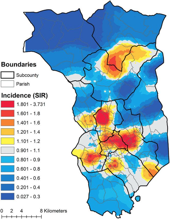
Beyer et al.

                               Uganda in eastern Africa ranks seventh in the world for cervical cancer incidence, with an estimated rate of
                               56.2 per 100 000 people in 2020 (compared to a global rate of 13.3) [7]. Cervical cancer is the leading cause
                               of cancer morbidity and mortality in Ugandan women with an estimated 6959 new cases and 4607 deaths in
                               2020 [7]. HPV vaccination rates remain low, with approximately 78% of girls unvaccinated in 2016 [8]. Cervi-
                               cal cancer screening rates are low, between 4.8%-30% among eligible women [9-11]. Treatment and palliative
                               care options are also limited for patients with advanced cervical cancer [12]. While Uganda had only one ra-
                               diotherapy machine serving the country and the region for some time [11,13], there are now three functional
VIEWPOINTS

                               external beam radiotherapy machines at the Uganda Cancer Institute – an improvement, though the unmet
                               demand remains high.
PAPERS

                               In resource-limited settings, targeting scarce resources to populations with the greatest need is critical to max-
                               imizing impact. Understanding with specificity where cancer burdens are concentrated has the potential to
                               greatly enhance the efficiency of cancer prevention and control efforts. Geospatial mapping of population-based
                               cancer registry data, used commonly in high-resource settings, has not been widely used in LMICs [14], with
                               notable exceptions, primarily outside of SSA [15-20]. High-resolution cancer maps could provide clear targets
                               for cancer prevention and control efforts in SSA and other low-resource settings, optimizing service delivery
                               for maximal benefit.
                               The objectives of this study were to geocode cervical cancer data from a population-based cancer registry in
                               Kampala, Uganda, to create high-resolution disease maps for potential use in cervical cancer prevention and
                               control planning, and to share lessons learned to strengthen future efforts in Uganda and other low-resource
                               settings. The implications of these findings for cervical cancer prevention and control are discussed.

                               METHODS
                               Study setting
                               The catchment area of the Kampala Cancer Registry (KCR) covers the population of Kyadondo County in Cen-
                               tral Uganda, which includes Kampala Capital City Authority (KCCA) and part of Wakiso district (Figure 1).
                               The population is predominantly Ganda from the Bantu ethnic group. The study area includes 11 sub-coun-
                               ties containing 146 parishes. The KCR office is located at the Makerere University, Mulago Hospital Complex
                               in the centre of the region. With regard to cancer care in the region, Mulago National Referral Hospital locat-
                               ed in Kawempe Division in Kampala District provides chemotherapy at the Uganda Cancer Institute while
                                                                  radiotherapy services are offered through the Department of Radiotherapy.
                                                                  Histology services in Kyadondo county are provided through two histopa-
                                                                  thology departments in Mulago Hospital and three private histopathologi-
                                                                  cal laboratories (Metromed, MultiSystems and Surgipath). In addition, there
                                                                  are three other missionary hospitals and a hospice facility that also provide
                                                                  cancer treatment services.

                                                                  Kampala Cancer Registry structure and operations
                                                                  The Kampala Cancer Registry (KCR) is housed in the Department of Pathol-
                                                                  ogy at the Makerere University College of Health Sciences and has the lon-
                                                                  gest time series of cancer incidence in Africa, with records dating back to
                                                                  the 1950s. Cancer is not a notifiable or reportable disease in Uganda, and
                                                                  therefore KCR carries out active surveillance. This involves cancer registrars
                                                                  regularly visiting multiple data sources, including hospitals, hospices, and
                                                                  histopathology laboratories. Within these units, and with the help of desig-
                                                                  nated staff in the records departments with retrieving clinical files, the reg-
                                                                  istrars peruse these files, inpatient and outpatient registers and pathology
                                                                  reports. Cases with a diagnosis of cancer are identified and data from those
                                                                  diagnosed while residents of Kyadondo County are abstracted onto notifica-
                                                                  tion forms. Place of residence is defined as the place the patient resided over
                                                                  the last 12 months. Patient residence at diagnosis is obtained from records
                                                                  across the different data sources. KCR reviews all records, including notes
                                                                  and referral letters, in order to identify the earliest residence corresponding
                                                                  to the date of diagnosis and confirm that the patient resided in the catch-
             Figure 1. Kampala Cancer Registry catchment area.    ment area at diagnosis. Data are then entered into the registry database using

             2022 • Vol. 12 • 04032                                          2                                www.jogh.org • doi: 10.7189/jogh.12.04032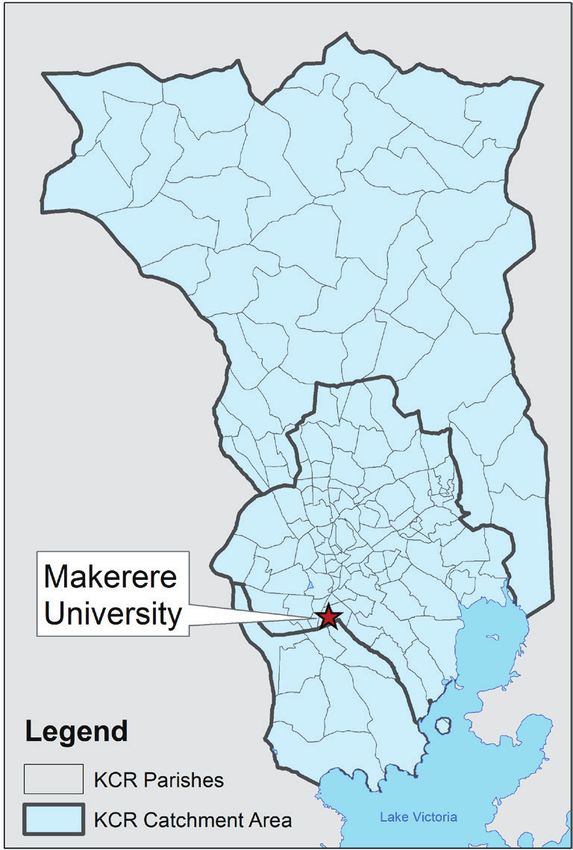
High-resolution maps for cancer control

                     the CanReg system, which at this stage of data entry prevents the use of non-valid codes and performs checks
                     for internal consistency among variables. The system also identifies potential duplicates and identified records
                     that are completed, corrected, or deleted after tracing the original archives in these various multiple sources.

                     Data sources
                     KCR tumour registry records were used to measure cervical cancer incidence. KCR data are commonly col-

                                                                                                                                                     VIEWPOINTS
                     lected via paper forms from local health care facilities and laboratories, which are then entered and stored
                     electronically. However, information on patient residence has not previously been available electronically, al-
                     though it has been collected in hard copy format. The CanReg database was modified to create new variables

                                                                                                                                                     PAPERS
                     for geographic units, aligned with Uganda Bureau of Statistics (UBOS) 2014 geographies [21]. Data for district,
                     sub-county, and parish of residence at diagnosis for cervical cancer was abstracted from KCR paper forms and
                     entered electronically. Not all paper forms included complete geographical information. In cases where the
                     parish of residence was available, but other geographies were not, KCR staff used internet searches (ie, Goo-
                     gle Maps) and an online land conflict map tool (http://www.lcmt.org/uganda) developed by the Ministry of
                     Lands in Uganda to identify the corresponding larger geographies: sub-county and district. Data entered were
                     limited to diagnosis dates between 2008 to 2015 (n = 1906). Age and sex-stratified census data for parish and
                     sub-county populations from 2014 (the most recent Ugandan census) for the Kampala and Wakiso districts
                     comprising Kyadondo county were obtained from the Uganda Bureau of Statistics (UBOS) and used to calcu-
                     late cervical cancer incidence ratios.

                     Data cleaning and preparation
                     The data abstracted from KCR paper records were examined and cleaned to ensure data quality. Abstracted data
                     were imported into STATA 15/SE (StataCorp, College Station, TX, USA). Data were explored and checked for
                     errors. Among 1906 records, 33 records were identified that fell outside of the KCR catchment area and were
                     excluded from the sample. Among the remaining 1873 records, 89.6% (n = 1678) of records included a valid
                     sub-county and 89.2% (n = 1671) of records contained a valid parish. 16 records had an unknown age. There
                     were seven records with valid sub-county but invalid parish data; given the small number of records, and to
                     ensure maps were comparable across geographic units used, we used one data set based on parish complete-
                     ness for the analyses. The final analytical data set included a total of 1655 records.

                     Data analysis
                     KCR data were summarized using descriptive statistics to describe the cohort. The cervical cancer Standardized
                     Incidence Ratio (SIR) was estimated for each sub-county and as a continuously defined surface, based on par-
                     ish-level data. Indirect age adjustment was selected instead of direct age adjustment, as is common in geospa-
                     tial studies, due to small local populations resulting in unstable local rates. For the sub-county analysis, ratios
                     (observed/expected) were calculated and then joined to sub-county boundaries. They were later marked using
                     a red-to-blue divergent colour scheme. Observed cases at the sub-county level were divided by the expected
                     number of cases for each sub-county, which was obtained by multiplying the overall catchment area age-spe-
                     cific rates with the number of people in each age group in each sub-county. Six age categories were used: 20-
                     29, 30-39, 40-49, 50-59, 60-69, and ≥70 years. Sub-county ratios were joined to sub-county boundaries and
                     marked using a red-to-blue divergent colour scheme. Then, to create a continuous surface map, the SIR (ob-
                     served/expected) was again calculated, this time based on parish-level data. The adaptive spatial filtering (ASF)
                     disease mapping method was used. In ASF, a grid of estimation points is placed across the study area and a
                     ratio is estimated at each grid point by pulling in data from multiple nearby locations (parish centroids) until
                     a pre-defined threshold is met. This approach maximizes geographic detail while ensuring statistical stability
                     of calculations and protecting data confidentiality [22]. ASF was implemented using R software. A uniform,
                     one-kilometre grid was used to estimate ratios across the map. We set thresholds for defining filters at 20, 25
                     and 30 expected cervical cancer cases to explore the influence of the threshold on resulting spatial patterns. A
                     final threshold value of 30 expected cases was selected. Observed and expected numbers were calculated and
                     located at each parish centroid. ArcGIS 10.6 was used to interpolate surfaces using inverse distance weighting
                     based on estimated cervical cancer standardized incidence ratios for each grid point to generate a continuous-
                     ly defined surface representing age-adjusted cervical cancer incidence across the study area. The continuously
                     defined map was additionally imported into Google Earth with 50% opacity to facilitate the interpretation of
                     identified patterns. Pertinent locations were also identified in Google Earth and included in visualizations to
                     enhance interpretation.

www.jogh.org • doi: 10.7189/jogh.12.04032                           3                                         2022 • Vol. 12 • 04032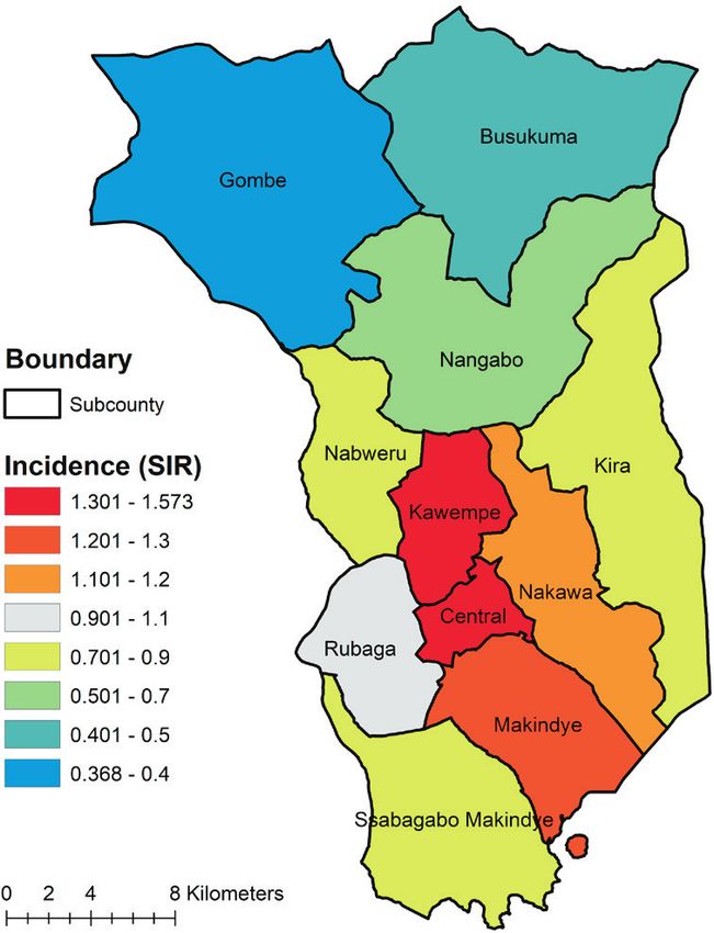
Beyer et al.

             Table 1. Characteristics of cervical cancer cohort in   Ethics approval
             the KCR catchment area (n = 1655)
                                                                     This work was reviewed and approved by the ethics boards at the Medical
              Characteristic                    Count    Percent     College of Wisconsin and Makerere University and approved by the Uganda
              Year of diagnosis:                                     National Council on Science and Technology.
              2008                               148        8.9
              2009                               150        9.1
              2010                               171       10.3
                                                                     RESULTS
VIEWPOINTS

              2011                               211       12.8
              2012                               278       16.8      Table 1 summarizes the characteristics of the cohort; it includes 1655 wom-
PAPERS

              2013                               210       12.7      en diagnosed with cervical cancer between 2008-2015, with approximately
              2014                               267       16.1
                                                                     150-280 women diagnosed each year. Recent years have had higher numbers
              2015                               220       13.3
              Age group (years):
                                                                     of cases, with the largest number of diagnoses in 2012 and 2014. The cohort
              20-29                              127        7.7      includes women aged 20-93 at diagnosis, with the largest percentage diag-
              30-39                              403       24.3      nosed at age 40-49. Tumour staging is limited by resource constraints and
              40-49                              467       28.2      is not comprehensive, with 54% missing stage information. Vital status was
              50-59                              343       20.7      identified as deceased for 13.6% of the population, but this number is likely
              60-69                              188       11.4      an undercount, given the limited resources for regular follow-up to confirm
              70 and above                       127        7.7      vital status. Numerous tribes were identified; only those with 50 or more
              Stage at diagnosis:                                    cases are listed in the table. The Baganda tribe comprised 57.5% of all cases.
              1 Localized                         69        4.2
              2 Local spread                     204       12.3      A map of cervical cancer incidence by sub-county is displayed in Figure 2.
              3 Regional spread                  311       18.8      The map reveals higher-than-expected cervical cancer incidence in Kawem-
              4 Advanced, distance metastasis     86        5.2      pe and Central sub-counties, with the lowest burden in Gombe sub-county,
              9 Stage not determined              87        5.3      in the northwestern part of the catchment area.
              Missing                            898       54.2
              Vital status:                                          A continuously defined map of cervical cancer incidence estimated using
              Alive                             1253       75.7      parish-level data is displayed in Figure 3. Cervical cancer incidence is not
              Deceased                           255       13.6      evenly distributed within sub-counties; there are patterns of higher- and low-
              Invalid code                       177       10.7      er-than-expected incidence within multiple sub-counties, offering evidence
              Tribes:                                                to guide the detailed targeting of interventions to at-risk populations.
              Baganda                            951       57.5
              Banyankore/Hima                    120        7.2      Figure 4, Panel A, shows a higher-than-expected incidence that extends hor-
              Banyarwanda                         73        4.4      izontally through the parishes of the Kawempe and Central sub-counties,
              Basoga                              59        3.6      eastward to the parishes of the Nakawa sub-county. On the western edge of
              Other                              381       23.0      the high-incidence area are key resources located in Kawempe sub-county,
              Unknown                             71        4.3      including the Uganda Cancer Institute, Ministry of Health, Mulago Hospi-

                                 Figure 2. Cervical Cancer Incidence by Subcounty, Kampa-   Figure 3. Cervical cancer incidence across the KCR Catchment
                                 la Cancer Registry Catchment Area, Uganda, 2008-2015.      area, spatially filtered using parish level data, 2008-2015.

             2022 • Vol. 12 • 04032                                             4                                 www.jogh.org • doi: 10.7189/jogh.12.04032
High-resolution maps for cancer control
tal, and The AIDS Support Organization (TASO) – TASO
being especially important, given the comorbidity be-
tween HIV and HPV. Also on the western side is the Ka-
tanga slum, nestled near Makerere University in Kawem-
pe sub-county. Crossing into Nakawa sub-county, there
is a higher-than-expected cervical cancer burden observed
on either side of Jinja Road, a major highway and trad-
VIEWPOINTS
ing route that connects Kampala to Jinja District. High
incidence is observed in the Naguru go-down, which is
PAPERS
a large slum including low-income households. Moving
eastwards, high cervical cancer incidence ratios are ob-
served in Kinawataka slum, another informal settlement
of low-income households located west of Kinawataka
road and south of Jinja Road in Nakawa sub-county. The
Kiswa slum, located south of the New Port Bell Road, also
has a high cervical cancer incidence. The Kiswa and Ki-
nawataka slums are located on the south and northeastern
side of Makerere University Business School in Nakawa
sub-county, respectively.
Figure 4, Panel B, shows high incidence north of the
Kampala Northern Bypass Highway, east of Bombo road,
and south of the Child and Family Medical Centre. The
Kalerwe slum has a higher-than-expected burden of cer-
vical cancer; it is a large, densely populated, informal set-
tlement with urban poor populations. Bombo road is the
main trading highway between Kampala and the North-
ern region of Uganda.
In Figure 4, Panel C, two high incidence ratio areas are
found in Rubaga and Makindye sub-counties. Hotspots
are seen in the Bulwa zone in Rubaga sub-county, which
is an industrial area. Commercial activities include small-
scale industries, a large Nalukolongo market, and the Na-
lukolongo railway hub, suggesting a high turnover of tran-
siting and resident populations in surrounding areas. In
Makindye sub-county, cervical cancer incidence is high
in the area east of Salaama road and the Makindye Mili-
tary barracks, on both sides of Lukuli road, south of Gga-
ba road.
In Figure 4, Panel D, there is high cervical cancer inci-
dence in the northern part of the KCR catchment area,
north of the Kasangati-Matugga road located in Nangabo
sub-county, and west of the Kabanyoro Agricultural Re-
search Institute of Makerere University.
Figure 4. Cervical cancer incidence rates overlaid in Google Earth. Pan-
el A. Kampala Central Division. Panel B. Kawempe Division. Panel C. DISCUSSION
Rubaga Division. Panel D. Nangabo Division.
This manuscript presents the first high-resolution maps
of cancer in sub-Saharan Africa using data produced from
an African population-based cancer registry. This analysis reveals areas of higher-than-expected cervical cancer
incidence that are potential targets for prevention and control activities. Some of these areas are located, fortu-
itously, in direct proximity to potentially important partners in reducing the cancer burden, including Makerere
University, Mulago Hospital, local government offices, and the Child and Family Foundation of Uganda clinic.
Kawempe sub-county has the highest cervical cancer incidence ratio and contains areas of high burden when
analysing parish-level data. Kawempe is centrally located and is the most densely populated administrative di-
vision in Kampala, with a total population of 338 665 [21]. Kawempe is comprised of a large business hub with
www.jogh.org • doi: 10.7189/jogh.12.04032 5 2022 • Vol. 12 • 04032Beyer et al.
large local markets supplied by several road networks [23]. Several large informal settlements like the Katan-
ga slum in Kawempe are associated with poor quality of life and are characterized by their poor housing con-
ditions and high poverty [24]. Kawempe is also affected by a high prevalence of HIV/AIDS, tuberculosis, and
their risk factors for transmission [24], which may also be related to HPV prevalence and cervical cancer risk.
According to Uganda’s Ministry of Health, Kawempe has an elevated risk of sexually transmitted infections and
a higher incidence of HIV compared to other divisions. As HPV is a sexually communicable virus, patterns of
sexually transmitted infections may correspond to patterns of cervical cancer. Commercial sex work is known
VIEWPOINTS
to be common and frequent among socializing populations in sites located in Kawempe compared to the gen-
eral population [25]. One study revealed that 75% of 227 hotspots for risky behaviours such as commercial
PAPERS
sex work and substance abuse were located in Kawempe [25]. Similarly, 19.2% of men and 12.8% of women
reported having paid and received payment for sex with at least one of their most recent three partners [25].
In addition, Kawempe has a high student population, as it includes the Makerere University Kampala (MUK),
and in one survey of five large universities in Kampala, a high proportion of female students had chlamydia
infection (2.5%) and syphilis (1.7%), while 0.8% and 4.3% of male students had chlamydia and syphilis in-
fections, respectively [26].
The spatially detailed cervical cancer maps presented can be used to advance clinical practice and public health
planning efforts to prevent and control cervical cancer in the Kampala, Uganda region. Maps can help to iden-
tify high-risk locations and populations to target emergent, innovative, cost-effective interventions for cervi-
cal cancer control such as pocket-sized, speculum-free colposcopes [27,28], improved screening colposcopy
techniques [29], and community-based HPV self-testing [30].
Limitations
This study is subject to several limitations. First, this is the first time geographic data collected by the KCR
was used. Because the geographic information had not previously been used, it was not a priority for data
entry, which resulted in geographical data omission and error. We have taken steps to enhance the quality
of geographic information included in the KCR database. A map of parish and sub-county locations, based
on UBOS 2014 boundaries, is now used as the reference map for entering geographic data into the database.
The paper form used to enter KCR data has been modified to separate geographies of interest into separate
fields, limiting error. Further, we have modified the CanReg software data entry interface to allow for direct
electronic entry of geographic data into distinct fields for district, sub-county, parish, and village by registry
staff, laying the foundation for high-quality geospatial analyses on multiple cancer types in the future. We are
actively seeking opportunities to support and enhance the operations of the KCR so as to enable high-quality
and timely geospatial analysis in the future. In addition, while KCR makes every attempt to identify the resi-
dential address at the time of diagnosis when registering cases, the recorded residence at diagnosis is subject
to potential misclassification. It is common in low-resource settings for individuals to come and stay near
health care facilities to receive treatment. However, their permanent residence may be further away. It is pos-
sible that some addresses obtained by KCR from health care facility records may be contact addresses (where
a patient is staying) rather than permanent addresses, although this may be more relevant for addresses during
treatment as opposed to place of residence at the time of diagnosis. This could result in lower-than-expected
incidence in outlying areas, impacting observed patterns. However, this also reveals the nature of geograph-
ic influences on health in low-resource settings. More work is needed to understand the nature of place of
residence in low resource settings, and how residential change, mobility and length of residence may impact
exposure and outcome relationships.
CONCLUSIONS
Cervical cancer is a preventable disease, with available vaccination, screening and treatment options, but it
continues to be diagnosed at high rates among African women and takes many lives. Limited resources should
be targeted to areas of greatest need, particularly for a cancer which is commonly the result of a sexually trans-
mitted infection. Mapping cervical cancer incidence with high geographic specificity is feasible in Uganda and
reveals clear spatial patterns that can inform resource allocation and support additional research. Future work
should identify causal factors associated with observed patterns of cervical cancer incidence, identify spatial
patterns of additional cancers, leverage spatiotemporal analysis to examine changes in spatial patterns over
time, and utilize maps to inform cancer prevention and control strategies targeting HPV vaccination and cervi-
cal cancer screening in Uganda. Future work should also explore residential histories and exposure measure-
ment in relation to cancer outcomes.
2022 • Vol. 12 • 04032 6 www.jogh.org • doi: 10.7189/jogh.12.04032High-resolution maps for cancer control
This type of approach would be further enhanced by developing a more precise and reliable disease surveillance
infrastructure to support decision-making and to better inform the implementation of cancer control strate-
gies and evaluate the impact of programs and policies. Increasing financial and operational support to African
cancer registries is essential, as the burden of cancer grows on the continent. Geospatial analysis of African
cancer registry data would be optimized through dedicated financial resources; training of cancer registry and/
or health facility staff to value, obtain and record geographic data; modification of existing data systems used
by LMIC registries (CanReg) to allow for new geographic variables; and alignment with existing census geo
VIEWPOINTS
graphies to enable population-based incidence rates and ratios to be calculated. Geocoded, population-based
cancer data are essential to an efficient and effective cancer control program and research into the geographic
PAPERS
factors influencing cancer outcomes.
Data sharing: The data analysed in this study are not publicly available. Requests for Kampala Cancer Registry or Ugan-
da Bureau of Statistics data should be made to those agencies directly.
Acknowledgements: We would like to thank the Uganda Bureau of Statistics for sharing data used in this work as well
as the funders identified below.
Funding: MCW Cancer Center, MCW Office of Global Health, AHW Endowment, Kohler Family Foundation, MCW
Class of 2001 Scott Sprtel Summer Research Training Fellowship.
Authorship contributions: KB conceived the study design, contributed to data preparation, conducted a literature re-
view, contributed to data analysis and interpretation and drafted the manuscript. SK contributed to study design and data
interpretation and reviewed/edited the manuscript. RA contributed to data preparation, analysis, and interpretation, con-
tributed to drafting the manuscript, and reviewed/edited the manuscript. RL contributed to study design and data inter-
pretation and reviewed/edited the manuscript. SN and PMA collected and prepared data and reviewed/edited the manu-
script. YZ led the data analysis, contributed to data interpretation, and reviewed/edited the manuscript. BN contributed
to data preparation and reviewed/edited the manuscript. CJ contributed to project management and data interpretation
and reviewed/edited the manuscript. TO contributed to study design and data interpretation and reviewed/edited the
manuscript. DS and KF contributed to data preparation and analysis and reviewed/edited the manuscript. HW oversaw
data collection and preparation, contributed to study design and data interpretation, and reviewed/edited the manuscript.
Competing interests: The authors completed the ICMJE Unified Competing Interest Form (available upon request from
the corresponding author) and declare no conflicts of interest.
1 Sung H, Ferlay J, Siegel RL, Laversanne M, Soerjomataram I, Jemal A, et al. Global Cancer Statistics 2020: GLOBOCAN Es-
timates of Incidence and Mortality Worldwide for 36 Cancers in 185 Countries. CA Cancer J Clin. 2021;71:209-49. Med-
REFERENCES
line:33538338 doi:10.3322/caac.21660
2 International Agency for Research on Cancer. Global Cancer Observatory. Available: https://gco.iarc.fr/. Accessed: 3 Septem-
ber 2021.
3 Sengayi-Muchengeti M, Joko-Fru WY, Miranda-Filho A, Egue M, Akele-Akpo MT, N’da G, et al. Cervical cancer survival in
sub-Saharan Africa by age, stage at diagnosis and Human Development Index: A population-based registry study. Int J Can-
cer. 2020;147:3037-48. Medline:32449157 doi:10.1002/ijc.33120
4 Parkin DM, Hämmerl L, Ferlay J, Kantelhardt EJ. Cancer in Africa 2018: The role of infections. Int J Cancer. 2020;146:2089-
103. Medline:31254479 doi:10.1002/ijc.32538
5 Forman D, de Martel C, Lacey CJ, Soerjomatarama I, Lortet-Tieulent J, Bruni L, et al. Global burden of human papillomavirus
and related diseases. Vaccine. 2012;30 Suppl 5:F12-23. Medline:23199955 doi:10.1016/j.vaccine.2012.07.055
6 Jemal A, Center MM, DeSantis C, Ward EM. Global patterns of cancer incidence and mortality rates and trends. Cancer Epi-
demiol Biomarkers Prev. 2010;19:1893-907. Medline:20647400 doi:10.1158/1055-9965.EPI-10-0437
7 GLOBOCAN. GLOBOCAN Uganda Fact Sheet. 2020. Available: https://gco.iarc.fr/today/data/factsheets/populations/800-ugan-
da-fact-sheets.pdf. Accessed: 11 April 2021.
8 Isabirye A, Mbonye M, Asiimwe JB, Kwagala B. Factors associated with HPV vaccination uptake in Uganda: a multi-level anal-
ysis. BMC Womens Health. 2020;20:145. Medline:32660461 doi:10.1186/s12905-020-01014-5
9 Ndejjo R, Mukama T, Musabyimana A, Musoke D. Uptake of cervical cancer screening and associated factors among women in
rural Uganda: A cross sectional study. PLoS One. 2016;11:e0149696. Medline:26894270 doi:10.1371/journal.pone.0149696
10 Black E, Hyslop F, Richmond R. Barriers and facilitators to uptake of cervical cancer screening among women in Uganda: a
systematic review. BMC Womens Health. 2019;19:108. Medline:31399092 doi:10.1186/s12905-019-0809-z
11 Nakisige C, Schwartz M, Ndira AO. Cervical cancer screening and treatment in Uganda. Gynecol Oncol Rep. 2017;20:37-40.
Medline:28275695 doi:10.1016/j.gore.2017.01.009
12 Mutyaba T, Mmiro FA, Weiderpass E. Knowledge, attitudes and practices on cervical cancer screening among the medical
workers of Mulago Hospital, Uganda. BMC Med Educ. 2006;6:13. Medline:16509979 doi:10.1186/1472-6920-6-13
www.jogh.org • doi: 10.7189/jogh.12.04032 7 2022 • Vol. 12 • 04032Beyer et al.
13 Abdel-Wahab M, Bourque J-M, Pynda Y, Iżewska J, van der Merwe D, Zubizarreta E, et al. Status of radiotherapy resources
REFERENCES in Africa: an International Atomic Energy Agency analysis. Lancet Oncol. 2013;14:e168-75. Medline:23561748 doi:10.1016/
S1470-2045(12)70532-6
14 Boulos DNK, Ghali RR, Ibrahim EM, Boulos MNK, Abdelmalik P. An eight-year snapshot of geospatial cancer research (2002-
2009): Clinico-epidemiological and methodological findings and trends. Med Oncol. 2011;28:1145-62. Medline:20589539
doi:10.1007/s12032-010-9607-z
15 Haidari LA, Brown ST, Constenla D, Zenkov E, Ferguson M, de Broucker G, et al. Geospatial planning and the resulting econom-
ic impact of human papillomavirus vaccine introduction in Mozambique. Sex Transm Dis. 2017;44:222-6. Medline:28282648
VIEWPOINTS
doi:10.1097/OLQ.0000000000000574
16 Tracy JK, Schluterman NH, Greene C, Sow SO, Gaff HD. Planning for human papillomavirus (HPV) vaccination in sub-Saha-
PAPERS
ran Africa: A modeling-based approach. Vaccine. 2014;32:3316-22. Medline:24731734 doi:10.1016/j.vaccine.2014.03.067
17 Zhang H, Tripathi NK. Geospatial hot spot analysis of lung cancer patients correlated to fine particulate matter (PM2.5) and
industrial wind in Eastern Thailand. J Clean Prod. 2018;170:407-24. doi:10.1016/j.jclepro.2017.09.185
18 Colak EH, Yomralioglu T. Geospatial analysis of cancer cases in the eastern black sea region of Turkey. In: Geospatial Tech-
niques for Managing Environmental Resources. Dordrecht: Springer Netherlands; 2012.
19 Miller MO, Voutchkov M. Risk analysis from naturally occurring radioactive materials in the Jamaican terrestrial environment.
Air Qual Atmos Health. 2016;9:551-60. doi:10.1007/s11869-015-0360-5
20 Winde F, Erasmus E, Geipel G. Uranium contaminated drinking water linked to leukaemia – Revisiting a case study from
South Africa taking alternative exposure pathways into account. Sci Total Environ. 2017;574:400-21. Medline:27639476
doi:10.1016/j.scitotenv.2016.09.035
21 2014 NPHC-Main Report Main Report National Population and Housing Census 2014. Available: www.ubos.org. Accessed:
11 April 2021.
22 Beyer KMM, Tiwari C, Rushton G. Five Essential Properties of Disease Maps. Ann Assoc Am Geogr. 2012;102:1067-75. doi:
10.1080/00045608.2012.659940
23 Fluegge K, Malone LL, Nsereko M, Okware B, Wejse C, Kisingo H, et al. Impact of geographic distance on appraisal delay for
active TB treatment seeking in Uganda: A network analysis of the Kawempe Community Health Cohort Study. BMC Public
Health. 2018;18:798. Medline:29940918 doi:10.1186/s12889-018-5648-6
24 Guwatudde D, Zalwango S, Kamya MR, Debanne SM, Diaz MI, Okwera A, et al. Burden of tuberculosis in Kampala, Uganda.
Bull World Health Organ. 2003;81:799-805. Medline:14758406
25 Ssekamatte-Sebuliba O Box JP, Jacqueline Tate Sengooba K, Sarah Bassett Hileman Sharon Weir iphacug, Ssengooba F, Sseka-
matte-Sebuliba J. PLACE in Uganda: Monitoring AIDS-Prevention Programs in Kampala, Uganda Using the PLACE Method
Priorities for Local AIDS Control Efforts (PLACE) Series, No. 2. 2003.
26 Rutherford GW, Anglemyer A, Bagenda D, Muyonga M, Lindan CP, Barker JL, et al. University students and the risk of HIV
and other sexually transmitted infections in Uganda: The crane survey. Int J Adolesc Med Health. 2014;26:209-15. Med-
line:24762640 doi:10.1515/ijamh-2013-0515
27 Asiedu MN, Agudogo J, Krieger MS, Miros R, Proeschold-Bell RJ, Schmitt JW, et al. Design and preliminary analysis of a vag-
inal inserter for speculum-free cervical cancer screening. PLoS One. 2017;12:e0177782. Medline:28562669 doi:10.1371/
journal.pone.0177782
28 Mueller JL, Lam CT, Dahl D, Asiedu MN, Krieger MS, Bellido-Fuentes Y, et al. Portable Pocket colposcopy performs compara-
bly to standard-of-care clinical colposcopy using acetic acid and Lugol’s iodine as contrast mediators: an investigational study
in Peru. BJOG. 2018;125:1321-9. Medline:29893472 doi:10.1111/1471-0528.15326
29 Lam CT, Mueller J, Asma B, Asiedu M, Krieger MS, Chitalia R, et al. An integrated strategy for improving contrast, durabili-
ty, and portability of a Pocket Colposcope for cervical cancer screening and diagnosis. PLoS One. 2018;13:e0192530. Med-
line:29425225 doi:10.1371/journal.pone.0192530
30 Ogilvie GS, Mitchell S, Sekikubo M, Biryabarema C, Byamugisha J, Jeronimo J, et al. Results of a community-based cervi-
cal cancer screening pilot project using human papillomavirus self-sampling in Kampala, Uganda. Int J Gynaecol Obstet.
2013;122:118-23. Medline:23731506 doi:10.1016/j.ijgo.2013.03.019
2022 • Vol. 12 • 04032 8 www.jogh.org • doi: 10.7189/jogh.12.04032You can also read


