Huntingdonshire Landscape and Townscape Supplementary Planning Document 2022 - Chapter 15 - Yaxley - of Huntingdonshire District Council
←
→
Page content transcription
If your browser does not render page correctly, please read the page content below
Huntingdonshire Landscape and
       Townscape Supplementary
         Planning Document 2022
Huntingdonshire District Council | Huntingdonshire Landscape and Townscape Supplementary
                                                                   Planning Document 2022

                                    Chapter 15 - Yaxley
Yaxley Key Service Centre 15
Huntingdonshire District Council | Huntingdonshire Landscape and Townscape Supplementary Planning Document 2022

          15 Yaxley Key Service Centre
          15.1   Yaxley is located in the north of Huntingdonshire immediately south of recent development at the Hamptons
                 in Peterborough and some five and a half miles from the city centre.

          Landscape Setting

          15.2   Yaxley is situated on a south facing slope rising above the northern edge of the Fen Margin Landscape
                 Character Area. The village has strong historic and visual links with the wider fen landscape which
                 characterises the southern edges of the village. There are expansive views south and south east across
                 this open agricultural landscape from the residential areas in the south of the village. This link between
                 the village and the surrounding landscape is reinforced in views toward the village from fens where the
                 spire of St Peter’s Church provides a notable landmark defining the western edge of the village.

          15.3   To the north of the village the landscape is dominated by modern and ongoing development at the Hamptons
                 within Peterborough on the former brickworks areas. It includes a country park which creates a degree of
                 separation between Yaxley and the Hamptons. From the north western edge of the village there are
                 glimpsed views to the higher ground and woodlands of the Central Claylands Landscape Character Area.

          Edges and Visual Prominence

          15.4   Yaxley is very prominent in views from the south given its ridgeline setting which gives clear views up to
                 development along Main Street and Church Street in particular. Much of the southern edge of the village
                 is softened by trees and hedging although rooftops can clearly be seen revealing the presence of the
                 village.

          15.5   The eastern part of Yaxley is cut through by the East Coast mainline railway which forms a distinct linear
                 feature in the landscape with substantial planting, particularly on the eastern side of the railway. Beyond
                 this sits the Broadway and Eagle Business Parks which present distinct edges to the village. Similarly,
                 the northern edges of Yaxley are dominated by straight edges of residential estates directly adjoining
                 fields and water bodies within the Hampton Country Park between them and recent development within
                 Peterborough at the Hamptons.

          15.6   The north western edges of Yaxley are shaped by the harsh line of the A15 (London Road). The south
                 western edges are much softer with substantial mature trees reducing the visual impact of the buildings
                 on the adjoining landscape. Open views from Church Street and Waterslade Lane across the immediate
                 landscape provide a high quality setting to the church and to a number of large residential properties along
                 the road.

          Townscape Character

          15.7   Residential development lines both sides of the B1091 corridor (Broadway) although the majority of older
                 housing lies to the south of the road on slopes overlooking the lowland landscape of the Fen Margin to
                 the east and south east. The B1091 (Broadway) links Yaxley with the A15 (London Road) to the west of
                 the village and with the village of Farcet to the north east. The East Coast mainline railway defines the
                 residential edge of the village to the east although land immediately east of the railway is dominated by
                 industrial and employment development associated with the Broadway and Eagle Business Parks.

          15.8   St Peter’s Church provides a notable landmark in views from within the village and from footpath locations
                 to the south and south west of the village edge. It is located on the site of the early medieval village which
                 is partially visible as earthworks to the north west of the church and is on the south western edge of the
                 current village. Over time, the village developed to the south and east along both sides of Main Street
                 creating a distinctive historic core along the southern edge of the village which broadly follows the five-metre
                 contour and which is still very much apparent. The original village core remains largely intact where there
                 is a stronger physical and visual relationship with the agricultural landscape of the Fen Margin. The linear
                 arrangement of historic buildings along Main Street and Church Street creates a strong sense of place

                                                                  485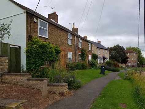
15 Yaxley Key Service Centre
Huntingdonshire District Council | Huntingdonshire Landscape and Townscape Supplementary Planning Document 2022
which is more intimate in scale than the post war residential estates to the north. The historic land uses
and agricultural past of the village are also apparent in the shape of plots facing onto Main Street and
extending down to Yards End Dyke.
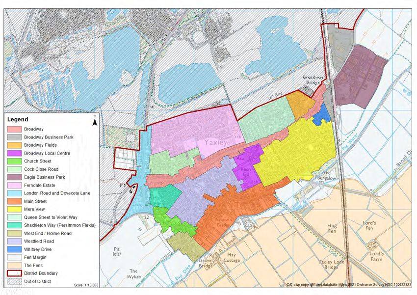
15.9 Yaxley has sixteen character areas (Figure 15.1 and can be viewed on the interactive map). Yaxley has
seen considerable growth and change through post war residential and industrial development. This
development has had a major impact on the character of the village which is now dominated by residential
estates and the influences of heavy traffic along the B1091 (Broadway). The central areas of the village
are, therefore, strongly suburban in character, those to the north of the village have no visual links to the
fen landscape which dominates the southern edges of the village. The area to the east of the railway is
industrial in character with the Broadway and Eagle Business Parks located here with large buildings in
active use, external storage and parking areas. These areas provide important local employment
opportunities.
486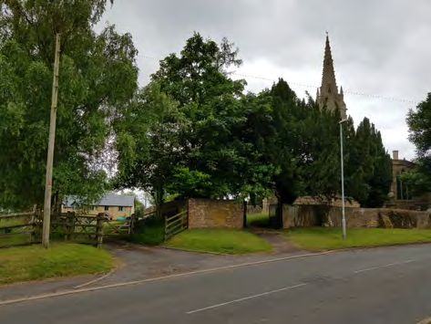
Legend
             I Broadway
             I Broadway Business Park
             I Broadway Fields
;;;;:;:;::;;:
                 Broadway Local Centre
                 Church Street
                 Cock Close Road
. _. . . .;jlj   Eagle Business Park
                 Ferndale Estate
                 London Road and Dovecote Lane
                 Main Street
                 Mere View
                 Queen Street to Violet Way
                 Shackleton Way (Persimmon Fields)                                                               Hog
                 West End / Holme Road                                                                           '1en
                                                                                                                              '
                 Westfi eld Road                                                                                              '

l                Whitney Drive                             Pit
I I Fen Margin                                             (dis)

                                                           y
                                                                                                                                                     rm
I I The Fens
~;;;;;
I           I Distriet Boundary                                     The
                                                                   WykesA
                 Out of District
                                         Scale, I ,0,000              /                                           ia'se   fig_'J ~ . 0[¥1 Ordnance

                                                                            Figure 15.1 Yaxley Character Areas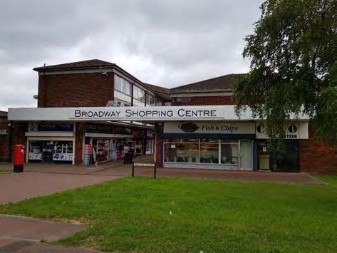
Page left blank intentionally
Yaxley Key Service Centre 15
Huntingdonshire District Council | Huntingdonshire Landscape and Townscape Supplementary Planning Document 2022

          Key Features

           Historic route               Church Street/Main Street

           Historic gateway             Church Street/Main Street

           Landmarks                    St Peter's Church

           Memorable areas              The Green, Main Street

           Key views                    South over the fen landscape and north toward Hampton Country Park

            Main Street hosts the majority of listed buildings within Yaxley and     The Fens landscape has strongly influenced the heritage and
             is most closely associated with its Fens and agricultural heritage.   character of the village, particularly to the south. Views out across
              Infill, redevelopments and additions over time have created an       the Fens landscape can be enjoyed from Church Street and Main
                              architecturally varied street scene.                                   Street with public rights of way.

           Yaxley has undergone considerable expansion over the last 25 years      Yaxley has two Established Employment Areas, one of which is the
            with some developments influenced by the abundance of arts and         Eagle Business Park with phase 2 of the park underway providing
           crafts and interwar housing found along key routes (e.g. Main Street,   employment opportunities for Yaxley residents and those in nearby
           London Road and Broadway) as well as within new estates such as                                   communities.
                                 Telford Drive, Ferndale.

                                                                               489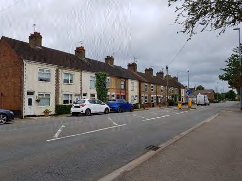
15 Yaxley Key Service Centre
Huntingdonshire District Council | Huntingdonshire Landscape and Townscape Supplementary Planning Document 2022

Yaxley Character Area 1: Main Street

   The Green is a historically significant area along Main Street
                                                                          197 Main Street is an example of a thatched vernacular cottage

15.10 Main Street has largely retained a village like feel and character. The character area is linear in form with
      Main Street running parallel to Yards End Dyke, a tributary of the River Nene. The community developed
      principally as a farming community with close ties to the Fens. Main Street has retained this connection
      much more so than the suburban character of the village to the north.

15.11 The vast majority of Yaxley's listed buildings and historic environment are
      located within this character area which has evolved over time. It also hosts
      the second largest range of uses outside of the Broadway Local Centre
      character area. The uses within the area include a place of worship, public
      houses, shops, opticians, an Amenity Centre housing the Parish Council
      offices, workshop, chambers and two public halls one of which is home to a
      pre-school, a fire and rescue station, Yaxley Infants School, restaurants, a
      dentist, offices and residential properties.
                                                                                                                    Three Horseshoes pub
15.12 This character area also provides the greatest variety of buildings types ranging
      from 1B, 2A, 2B, 2E, 3B, 3D, 3E, 3F, 6B and 7A. As such there is a mixture of building materials present
      including stone, brick, timber framing and rendering with traditional roofing materials such as slate
      and thatch. This is largely attributed to Yaxley's location on the southern periphery of the Peterborough
      brick-fields making brick a key material in the village. Local brick production started in the 16th century
      with large-sale manufacture commencing at the nearby Norman Cross and Beeby's Works in the Victorian
      age resulting in many properties that date to the 19th and early 20th century being constructed from local
      materials.

15.13 At the junction between Church Street and Main Street development is noticeably denser with a strongly
      linear character and a hard landscaped semi-urban environment with development on both sides although
      the footpaths are generally quite wide so there is a limited sense of enclosure. Properties opposite the
      junction form a strong terminal feature to long distance views across the Fens. Infill opportunities over
      time have reduced remaining views outside across the Fens landscape.

                                                                    490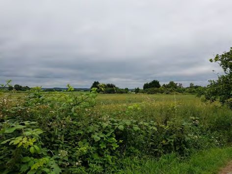
Yaxley Key Service Centre 15
Huntingdonshire District Council | Huntingdonshire Landscape and Townscape Supplementary Planning Document 2022

          15.14 Main Street hosts some vernacular buildings dating to the 17th and 18th
                centuries which are dispersed throughout the character area representing
                building type 1B. The character area contains many examples of Victorian
                and Edwardian homes and institutional, educational and non-conformist
                buildings including the Owen Pooley Hall and Council Chambers, the Methodist
                Church and St Bartholomew's Hall, some of these structures have since been
                listed. There were several public houses however only The Duck and Drake
                and The Three Horseshoes are still operational. The Royal Oak is a grade II
                listed property which has since been converted into a house.                         Victorian fire station building with
                                                                                                                     a modern addition
          15.15 The character area also has a triangular village green between Main Street, Middletons and The Green.
                It has two listed structures on it including the Victorian village pump and early 20th century post box.
                Neighbouring this is a larger island located between Main Street, The Green and Middletons Road. 88
                Main Street (a red brick thatched cottage) forms a significant terminal building as the road forks and rises
                slightly between Main Street and Middletons Road. Here there are several examples of Victorian terraces
                and cottages. The open space in front of properties and increased tree and general planting in this part
                of the character area provide a particularly attractive village environment.

          15.16 To the rear of properties on the southern side of Main Street, there are some
                long narrow strips of land which stretch toward Yards End Dyke. Some are
                overgrown and some have outbuildings and storage sheds. These narrow
                land parcels create the distinct break between the built environment of the
                village and the natural environment of the Fens. These land parcels represent
                the historic land tenure consequent on the necessities of subsistence and
                agriculture, coupled with the need to have a frontage onto Main Street. This
                historic form has largely been retained and has shaped the nature and evolution
                of the village. These parcels, particularly those that are vacant, offer the         View out across the Fens
                                                                                                   landscape from Main Street
                opportunity for some minor scale redevelopment which can enhance the
                conservation area and be positively integrated with the surrounding area, an example is Needham Court.
                Another opportunity to do this is on site allocation YX1 in the Huntingdonshire Local Plan to 2036 which
                has since gained planning approval for nine properties.

          15.17 From Holme Lane and Askew's Lane public rights of way follow Yards End Dyke and lead to isolated
                properties and outbuildings as well as a football ground and allotments.

          15.18 Throughout the character area, there are abundant examples of 20th and 21st
                century infill development. Many have replicated key features found throughout
                the conservation area such as the materials, colour palette, dormer windows
                and the style and form of properties, however, some earlier examples from
                the middle of the 20th century have not integrated such features as
                successfully. As the character area extends northwards along Main Street,
                larger quantities of such development can be found alongside some Victorian
                terraces forming a transitional point with the wider suburban expansion the
                village underwent during the mid 20th century onwards. These are retained            161-163 sympathetic modern
                                                                                                               infill development
                along Main Street as they reflect and continue the linear nature of the character
                area and a similar land ownership pattern extending to Yards End Dyke. At the very eastern edge of Main
                Street, development ceases on the southern side of Main Street providing views out over the flat fenland
                landscape to those properties on the northern side. This is important as these are the most extensive view
                of the Fens from Main Street and give a rural setting to this part of the village core.

          15.19 This is a characterful and historic area whose conservation is a priority. Development opportunities
                are limited to changes of use, small scale infill proposals, extensions and alterations to existing properties.

                                                                   491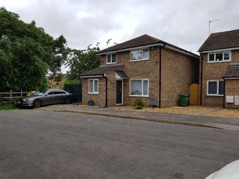
15 Yaxley Key Service Centre
Huntingdonshire District Council | Huntingdonshire Landscape and Townscape Supplementary Planning Document 2022

  Development proposals should:

  •    Conserve or where appropriate enhance the significance of the heritage assets including any contribution
       made to significance by their settings.
  •    Enrich the character of the area by reinforcing and acknowledging its historic character, in particular
       its connections to its agricultural and Fenland heritage.
  •    Reflect the existing materials and colour palette of predominately brick and stone in particular those
       that can be sourced locally.
  •    Support initiatives for the retention of existing or creation of additional services and community facilities.
  •    Conserve and reflect the features and characteristics of Main Street through the control of shopfront
       design and building renovations.
  •    Promote high standards of design and architectural detailing to enhance the historic character of the area
       and conservation area.
  •    Maintain and where possible promote opportunities for enhancement of open space and
       recreational facilities.
  •    Protect the existing mature trees and planting where these contribute to the character of the street
       scene.
  •    Conserve and maintain the village greens and open space within this area.
  •    Maintain and enhance physical and visual connections to key buildings and landscape views, particularly
       those over the Fen landscape.
  •    Not increase the amount of water that enters the Yards End Dyke drainage channel or encroach on
       the required 20m maintenance wide access strip to it. A flood risk assessment and drainage management
       plan will be required to assess this.
  •    Provide safe access onto Main Street, where access is particularly narrow it may be appropriate to
       demolish existing home(s) within the site area.
  •    Maintain and enhance where possible opportunities for public rights of way.

                                                        492
Yaxley Key Service Centre 15
Huntingdonshire District Council | Huntingdonshire Landscape and Townscape Supplementary Planning Document 2022
Yaxley Character Area 2: Church Street
View of the Church spire and wall along Church Street. Tree planting Terraced development on raised ground along Church Street
contributes heavily to the character of this area
15.20 Church Street is located to the north west of Main Street and has a much more open and rural feel than
Main Street with established hedgerows. Properties are generally located on its western side when travelling
toward Main Street where the road also slightly descends resulting in some properties being raised from
the roadside. These properties have views out across agricultural fields and the natural landscape with
St Peter's Church forming a dominant landmark.
15.21 The character area has several listed buildings with building types varying from 2A, 2B, 2E, 3B, 3D, 3E,
3F and 6A. Within Yaxley the greatest concentration of stone is found around St Peter's Church (a grade
I listed building) whose walls are constructed from roughly coursed rubble limestone and Barnack stone
ashlar. This is due to the village's close location to the Nene Valley which contains the main concentration
of historic stone buildings in Huntingdonshire.
15.22 Church Street is set set in a slight cutting and is bordered by a grassy bank
which contributes to its rural feel with established trees and hedgerows which
almost completely obscure some properties. Most properties along here date
from the 18th and 19th centuries and are set in substantial grounds with walling,
railings and hedgerows along the street frontage. Examples include Manor
Farm, the Vicarage, Church Farm and The Laurels. These are not of uniform
age or materials but in combination provide a rich street scene. Of these,
only Manor Farm is listed and is stone built with a Collyweston stone slate
roof. Its farmyard had a traditional courtyard built of stone which has since 15 and 15a Church street
sympathetic infill development
been converted to residential use with further detached homes built around
the central pond in a similar style. Some infill development has taken place along Church Street which
has generally been sensitively integrated.
15.23 There is a right of way connection from Church Street to Vicarage Way across some natural grassland
complementing the surrounding built environment and providing amenity space for residents. Continuing
this theme is Laurel Close, a series of 20th century houses arranged around a central greenspace with
planting. This widens the street scene on the approach to Main Street.
15.24 This is a sensitive area with landscape and heritage being key considerations.
49315 Yaxley Key Service Centre
Huntingdonshire District Council | Huntingdonshire Landscape and Townscape Supplementary Planning Document 2022
Development proposals should:
• Conserve or where appropriate enhance the significance of the heritage assets along Church Street
including any contribution made to significance by their settings.
• Enrich the character of the area by reinforcing and acknowledging its historic character, in particular
its connections to its agricultural and Fenland heritage.
• Reflect the existing materials and colour palette of predominately brick and stone in particular those
that can be sourced locally.
• Promote high standards of design and architectural detailing to enhance the historic character of the
area and conservation area.
• Protect the existing mature trees and hedgerows where these contribute to the character of the street
scene.
• Conserve and maintain the village greens and open space within this area.
• Maintain and enhance physical and visual connections to key buildings and landscape views, particularly
those over the Fen landscape.
• Promote opportunities for enhancement of amenity green spaces to provide increased opportunities
for recreation and nature conservation and to help provide distinctive local landmarks.
494Yaxley Key Service Centre 15
Huntingdonshire District Council | Huntingdonshire Landscape and Townscape Supplementary Planning Document 2022
Yaxley Character Area 3: West End/ Holme Road
Wykes Road Cookson Close central greenspace with homes around it
15.25 This is a small character area located to the south west corner of the village adjoining Main Street and
with a strong relationship with the fen landscape. West End links to Main Street to the east. The properties
found within West End are arranged around two main roads: Wykes Close and Cookson Close. The
character area also includes a small area of industrial and employment uses facing Holme Road to the
south of Main Street and adjoining the rear boundary of properties along Cookson Walk.
15.26 Properties along Wykes Close representing building type 3D constructed of brown brick with hanging
tiles and weatherboarding used as decorative cladding. There are a mixture of two storey homes and
bungalows with a reasonable set back to the road enabling pockets of green space throughout. Garages are
typically to the side or in garage courts. Where building heights are lower, the distinctive landmark of St
Peter's Church can be seen.
15.27 Properties within Cookson Close and Abbotts Road date to the 1980s/90s and demonstrate building type
3E. They are typically larger detached homes with some semi-detached and terraced homes providing
variety. Many are constructed from red brick with dark roof tiles while other properties include a greater
mix of red, buff and brown brick, mock Tudor panelling and rendering. They have on plot garages and
fewer areas of green space throughout but instead have a central green area around Cookson Walk
providing a strong focal point.
15.28 The industrial workshops facing Holme Road are mostly single storey constructed from brick with some
cladding. They are separated via metal fencing from Holme Road, trees and planting within the rear
gardens of adjoining properties providing some screening from these industrial uses.There is a considerable
amount of hardstanding for parking. The building type these buildings most closely relate to is type 5B.
15.29 At the end of West End there is a public right of way enabling routes out across the countryside. The
southern most corner of the area running to the east and west follows that of the drainage channel of
Yards End Dyke. The right of way leads onto Holme Road over Gravel Bridge and northwards to the
allotment ground and football ground. Holme Road carries on in a south easterly direction where sporadic
homes, farm buildings and industrial buildings are located throughout the fen landscape.
15.30 This is a sensitive area due to its location on the edge of the village and the closer association it has with
the fenland landscape. Development proposals are therefore limited to extensions and alterations to
existing properties.
49515 Yaxley Key Service Centre
Huntingdonshire District Council | Huntingdonshire Landscape and Townscape Supplementary Planning Document 2022
Development proposals should:
• Enhance screening and adequately mitigate amenity issues arising from proposals within the industrial
uses along Holme Road.
• Encourage and retain tree and hedge planting on the boundary edges of the area to reduce the impact
on the wider countryside in particular the Great Fen Landscape and Visual Setting and long distance
views to the south.
• Maintain and enhance physical and visual connections to key buildings and landscape views, particularly
those over the Fen landscape.
• Not increase the amount of water that enters the Yards End Dyke drainage channel.
• Ensure extensions and alterations to existing properties are of an appropriate size and scale to the
original dwelling and do not detract from the surrounding area.
• Be sympathetic to the materials and colour palette including red and buff brick, dark roof tiles and where
possible provide increased architectural detailing.
• Protect the existing trees where these contribute to the character of the street scene and consider ways
of increasing vegetation cover where space and service restrictions permit.
• Promote opportunities for enhancement of amenity green spaces to provide increased opportunities
for recreation.
• Maintain and enhance where possible opportunities for public rights of way out across the Fens.
496Yaxley Key Service Centre 15
Huntingdonshire District Council | Huntingdonshire Landscape and Townscape Supplementary Planning Document 2022
Yaxley Character Area 4: London Road and Dovecote Lane
Semi-detached properties along London Road At the point where London Road, Broadway and Dovecote Lane
meet are a series of traffic lights and the road widens
15.31 This is a linear character area focused around London Road (A15). It extends northwards towards
Peterborough and to the Norman Cross roundabout to the southwest. The open countryside lies to the
west. Buildings in this character area are predominantly residential with a filling station and cemetery and
chapel located to the south. The character area is dominated by the road and its associated signage and
traffic lights. Residential development is located on either side of London Road and is of mixed ages, there
is some in depth development. Building types in this character area are therefore mixed ranging from 3A,
3B, 3D, 3E and 3F.
15.32 Examples of interwar housing (building type 3B) are common with a few arts
and crafts style properties (type 3A). Many are designed with double bay
windows with rendered or tile hung panels which are defining features for this
development type.They are also either detached or in semi-detached pairs with
a central chimney stack in rectangular plots with generous front and rear
garden space creating a low to medium density form of housing.
15.33 Later forms of development have replicated the rectangular plots and medium
density form and range from two storey detached properties to semi-detached, 2 London Road
chalet style and single storey properties. Infill development during the latter
part of the 20th century and into the 21st have further diversified the housing in this area. Examples of
modern additions can be found on the site of the former Anglian Water pumping station on London Road
at the junction with the Broadway. These properties have reflected the wider style of the area as well as
positively reused a disused site.
15.34 Development is generally well separated from the road with a footpath running
on the eastern side of the road and generous front gardens which are mostly
paved and serve as on plot parking. Hedges and trees form an important visual
separation from the road as well as provide a green feel to the area. On the
western side, a verge separates properties from the road with an access
route from the A15 to these properties, an example is Folly Close.
15.35 At the southern end of the character area on land between the fork in the road
layout between London Road and Waterslade Road is a chapel and cemetery. New builds on the former Anglian
North on Waterslade Road is Dovecote Lane. Heading north on Dovecote Water station
Lane, there is a junction back onto London Road and also access onto Broadway, green spaces provide
49715 Yaxley Key Service Centre
Huntingdonshire District Council | Huntingdonshire Landscape and Townscape Supplementary Planning Document 2022
additional separation from this busy junction. Dovecote Lane demonstrates a more peaceful nature than
that of London Road as a result of the cemetery grounds, however it shares its general pattern of
development with its northern most part connecting to the junction with London Road which justifies
extending the character area to include this part. It also hosts building types 3B, 3D, 3E and 3F. The
Yaxley Cemetery Chapel located at the very south of the area at the junction with Waterslade Road/Church
Street and Dovecote Lane dates to the 1880s (building type 7A) and is set in a large grounds behind a
fence with tree planting largely obscuring it from view providing a more tranquil feel.
15.36 This is a sensitive area due to it connections to the transport network and the open
countryside. Development opportunities are limited but include small scale infill development and extensions
and alterations to existing properties.
Development proposals should:
• Provide safe access onto London Road (A15) and not adversely impact the highway network.
• Protect the existing trees and vegetation where they contribute to the street scene and reinforce the
separation of traffic noise and visual impact on residential amenity.
• Ensure extensions and alterations to existing properties are of an appropriate size and scale to
the original dwelling and do not detract from the surrounding area.
• Be sympathetic to surrounding existing materials and colour palette.
• Support provision of renewable energy where visually appropriate.
• Promote high standards of design and architectural detailing.
• Provide screening and tree/hedge planting to mitigate the impact on of development on the wider
countryside.
• Respect the quieter nature at Waterslade Road/Church Street and Dovecote Lane area.
498Yaxley Key Service Centre 15
Huntingdonshire District Council | Huntingdonshire Landscape and Townscape Supplementary Planning Document 2022
Yaxley Character Area 5: Broadway
Variation in housing design and styles found along Broadway Mixed terraces along Broadway
including bungalows
15.37 This is a linear character area with its western edge extending from the junction with London Road (A15)
and up to the East Coast mainline railway at its eastern edge. It includes development immediately fronting
Broadway (B1091) which is continuously developed with occasionally breaks in the street scene. Building
types are varied ranging from types 2A, 3A, 3B, 3D, 3E and 3F. While the housing types are not solely
found within this part of the village, their relationship and character is greatly influenced by their proximity
to Broadway. This is a busy road with high levels of traffic moving through this area.
15.38 Development is predominantly residential and is some of the oldest outside
of Main Street with numerous examples of interwar housing and arts and crafts
housing as well as Victorian/Edwardian terraced housing. Plot sizes are fairly
regular with rectangular plots, the terraced housing has the most extreme
example of very narrow and long plots with little degree of separation from the
footpaths along Broadway. The later more suburban styles of properties are
more spacious with a larger set back from the road and grouped
in semi-detached pairs providing more medium density housing and space
for on plot parking behind a mixture of low hedges and low boundary walls Modern extension to property
and fencing. Infill development over the latter half of the 20th century and into the 21st century have
diversified the housing types. Throughout the area there is a mixture of detached, semi-detached and
terraced properties mostly of two storeys but some bungalows. Materials in this area vary with red and
buff brickwork, render and rough cast render and some mock Tudor panelling. Design features include single
and double bay windows, central chimney stacks on semi-detached properties and shallow pitched roofs.
15.39 Other uses within this area include a filling station, shops, offices, children's
nurseries, hairdressers, clubhouse, bowling green, Wiles Haulage Company
and the Farmers Carvery and Grill. Some shops and offices operate from the
ground floor of residential properties. The mixture of building types and their
operational requirements such as car parking areas and signage provide
variations in the street scene. Those not operating from a residential type
property are most closely related to building type 7B.
15.40 The street scene is dominated by the road, signage and traffic lights. There The Farmers Carvery and Grill
is some planting throughout providing some greenery and screening to
residential properties. The largest green space within this area is located between Broadway and Speechly
49915 Yaxley Key Service Centre
Huntingdonshire District Council | Huntingdonshire Landscape and Townscape Supplementary Planning Document 2022
Road opposite the Broadway Shopping Centre where traffic lights and a crossing point is located. This
island is a mixture of grass and pavement with areas to sit with tree planting. This provides a somewhat
calmer space within this generally busy area as well as a break in the street scene.
15.41 This is sensitive area due to the busy B1091. Development proposals are therefore limited with highways
safety being a key consideration.
Development proposals should:
• Provide safe access onto Broadway (B1091) and not adversely impact the highways network.
• Protect the existing trees and vegetation where they contribute to the street scene and reinforce the
separation of traffic noise and visual impact on residential amenity.
• Ensure extensions and alterations to existing properties are of an appropriate size and scale to
the original dwelling and do not detract from the surrounding area.
• Be sympathetic to surrounding existing materials and colour palette.
• Increase resident amenity by incorporating screening and physically separation between new properties
and road potentially through boundary walls/fencing and hedge planting.
• Promote high standards of design and architectural detailing.
• Support initiatives for the retention of existing services and community facilities.
• Ensure signage does not adversely impact highways safety.
• Ensure that shopfront designs are appropriate within the street scene.
• Protect existing planting where it contributes to the street scene.
• Support provision of renewable energy where visually appropriate.
500Yaxley Key Service Centre 15
Huntingdonshire District Council | Huntingdonshire Landscape and Townscape Supplementary Planning Document 2022
Yaxley Character Area 6: Broadway Local Centre
Broadway Shopping Centre Recreational grounds within this area which are centrally located
within the village with numerous points of access for residents
15.42 Broadway Local Centre is a centrally located character area on the south side of Broadway and adjoins
extensive areas of residential development to the south and east. After Main Street it has the most diverse
range of uses that are important to local residents for day to day living and employment. The community
facilities and services found here include the Broadway Shopping Centre, a library, William de Yaxley
Primary School, Yaxley health centre and recreation grounds with synthetic turf pitches. These fall within
building types 5D and 7B. Due to the range of uses and the need for open and play space as well as car
parking, the character area has a generally open feel to it albeit there is also extensive amounts of fencing
and boundary markers differentiating the various operational requirements of each facility.
15.43 The Broadway Shopping Centre in Malting Square opened in the mid-1960s.
It is a covered area consisting of 19 units occupied by local and national
operators for shops, takeaways, convenience stores and banking machines
with residential flats over some premises. Extensions over time have increased
the capacity of the shopping centre and have assisted in reinforcing the street
frontage with large areas of glazing to the frontage that add interest and
provide an active frontage. Around the centre is hardstanding used for car
parking, a low boundary wall provides some separation between Malting
Square and the street scene. An additional building to the south also provides Green grocers
shops, services and flats within this area. Both buildings are constructed of red brick and have a variety
of building heights.
15.44 The William de Yaxley Junior School is a large single storey building set behind fencing. It has large
amounts of open space around it with access from Landsdowne Road. Playing fields are located to the
west with a tree belt separating it from the larger public recreational ground to the south. The recreational
ground is a large centrally located piece of open space with access from Lansdowne Road, from Main
Street to the south and Middletons Road from the west. It has two adult football pitches, a 3G pitch, an
outdoor gym, toddler and junior play areas, a floodlit multi activity area, skate ramps, community orchard
and a pavilion which is the home to the Yaxley Community Fridge. Trees are planted along its boundaries
and within the grounds, many are protected with tree preservation orders.
50115 Yaxley Key Service Centre
Huntingdonshire District Council | Huntingdonshire Landscape and Townscape Supplementary Planning Document 2022
15.45 The Health Centre is a large building with the majority at single-storey and an
octagonal form for as the two-storey element. The existing building is
unconventional in appearance. There is a small car park within the curtilage
to the front with hedging and planting along its access from Landsdowne Road
adding greenery and softening the impact of the facility with the adjoining
residential properties. An additional care facility has recently been built to the
west of the existing Health Centre facing onto the recreation grounds.
15.46 This an important area for Yaxley residents, there is scope for extensions to Health Centre
existing services and facilities to create additional school rooms, consultation
rooms and small retail units as well as proposals that enhance the existing provision in this area.
Development proposals should:
• Ensure that development responds positively to the specific opportunities available to reinforce
the educational, health, retail and recreational uses in the area.
• Support and retain the current uses in the character area through renovation, refurbishment or extensions
to buildings.
• Reflect appropriate architectural detailing, materials and colour palette in the design of new buildings
and provide where possible active frontages.
• Ensure that there is adequate car parking provided with any extension to the health centre and shopping
centre.
• Consider and mitigate any potential harmful increase in vehicular movements from Broadway (B1091)
and on the wider local transport and highway network.
• Protect the existing open space and grass verges that provide the spacious setting to development.
• Maintain and enhance where possible hedge planting along boundaries and along Lansdowne Road
to reduce harm to resident amenity.
• Support provision of renewable energy where visually appropriate and potentially electric vehicle
charging points.
• Support provision of facilities which encourage active modes of transport and increased permeability
within the area and adjoining residential area.
• Provide appropriate non-illuminated signage to protect neighbouring resident amenity and highway
safety.
• Avoid the loss of trees and planting where these contribute to the street scene and recreation ground,
particularly those protected by a Tree Preservation Order.
502Yaxley Key Service Centre 15
Huntingdonshire District Council | Huntingdonshire Landscape and Townscape Supplementary Planning Document 2022
Yaxley Character Area 7: Shackleton Way (Persimmon Fields)
A mixture of homes along Shackleton Way looking toward the green A larger detached home with some decorative weatherboarding
and play space looking onto greenspace
15.47 This is a small character area accessed via Broadway with a footpath from Dovecote Lane. To the east
it abuts rear gardens of properties along Field Rise and Vicarage Way and to the west it abuts gardens
of properties along Dovecote Lane. While surrounded by earlier development, it has been split out into
this character area due to the contrast in style and the clear difference in character within the area. Its
principal road is Shackleton Way, however the area was developed under the name Persimmon Fields.
15.48 Shackleton Way is a major infill development with properties arranged around a loop road. It contains 125
homes demonstrating building type 3F. The main materials and colour palette of the area consist of red
and buff brick, render, grey and red roof tiles with some coloured weatherboarding. Housing is typically
denser with most arranged in a series of short terraces with several examples of flats built over garages
and coach house style over access routes to rear parking courts. The development consists of a mix of
2-5 bedroomed properties with detached properties located around the periphery of the site looking over
the greenspace.
15.49 The greenspace incorporates a village green with a public walk way linking though it to Dovecote Lane.
It also has a pond and play area and is a key area of open space for residents. Its location on the
western site of the character area also provides a stronger link to the character of the adjoining conservation
area and the residential development at Manor Farm.
15.50 Development opportunities are limited to extensions and alterations to existing properties.
Development proposals should:
• Ensure extensions and alterations to existing properties are of an appropriate size and scale to the
original dwelling and do not detract from the surrounding area.
• Be sympathetic to surrounding existing materials and colour palette of buff or red brick and grey or red
roof tiles.
• Ensure that new development responds positively to the specific opportunities available within the area.
• Promote opportunities for enhancement of amenity green spaces to provide increased opportunities
for recreation and nature conservation and to help provide distinctive local landmarks.
• Maintain and enhance physical and visual connections to key buildings.
50315 Yaxley Key Service Centre
Huntingdonshire District Council | Huntingdonshire Landscape and Townscape Supplementary Planning Document 2022
Yaxley Character Area 8: Westfield Road
Vicarage Way bungalows Raised properties with a considerable set back from Westfield Road
creating a wide street scene
15.51 This is a residential character area located to the west of the Broadway Local Centre and south of Broadway.
To the south and west it borders the Main Street and Church Street character areas. The majority of
development within this character area dates to the 1970s and 80s with some earlier terraced and interwar
properties found at the northern ends of Chapel Street and Middletons Road. Therefore, building types
are somewhat mixed with 3B predominating but with some 2A, 3B, 3E and 3F. Uses within the area are
mainly residential complemented by several care facilities.
15.52 Throughout the area there is a mix of two storey and single storey properties, however there is a much
greater proportion of bungalows found within this character area than any other within Yaxley. Lee Road
and Stonehouse Road are examples of streets mostly consisting of bungalows. This has reduced the
visual impact of 20th century development on the historic built and landscape features as heading north
along Westfield Road the gradient of the road slopes upwards. Therefore, the area is more closely related
to the conservation area, Main Street and Church Street to the south and west. The influence of these
can be seen in Vicarage Way for example where the spire of St Peter's Church shows in between and
above the existing building line. This is reinforced by a footpath connecting Vicarage Way and Church
Street.
15.53 The area has several individual and blanket tree preservation orders, most examples are found along
Chapel Street and Blenheim Way. These in combination with other planting provides a green and natural
feel to the area complementing the residential and care uses of the area. Some properties are obscured
or partially obscured from view.
15.54 Hillcrest Avenue is a collection of semi-detached homes of simple red brick
design with a central green providing a tranquil setting. Properties have a large
set back from the road enabling on plot parking accentuating the sense of
space. They also have a mixture of low boundary walls and low hedges which
clearly mark out public and private space and add additional greenery to this
residential road.
15.55 Materials within the area include buff, red and grey brickwork, red and dark
roof tiles with some examples of coloured weatherboarding and textured Hill Crest Avenue
materials to provide variation to front elevations. Design details include gabled
roofs, smaller gables to front elevations, canopies and small porches. Some properties have been altered
504Yaxley Key Service Centre 15
Huntingdonshire District Council | Huntingdonshire Landscape and Townscape Supplementary Planning Document 2022
and extended. Some boundary features and planting within front gardens clearly define public and private
space and provide some greenery and planting to the street scene. This set back also provides a more
spacious and wider street scene complementing the residential nature of the area.
15.56 While the general layout and form of the area is consistent, there are several
exceptions which contrast this, namely Snowhills on Blenheim Road/
Middletons Road and Spinney House along Chapel Street. Both are over 55s
retirement housing. Snowhills consists of 41 one bedroom flats built in 1981
while Spinney House has 14 one and two bedroom flats for over 55's built in
2011.
15.57 Development opportunities are limited to extensions and alterations to existing
properties. Spinney House
Development proposals should:
• Ensure extensions and alterations to existing properties are of an appropriate size and scale to the
original dwelling and do not detract from the surrounding area.
• Be sympathetic to the materials and colour palette of buff, red and grey brickwork, red and dark roof
tiles.
• Promote high standards of design and architectural detailing.
• Support provision of renewable energy where visually appropriate.
• Protect the existing mature trees and hedgerows (in particular those protected by a Tree Preservation
Order) where these contribute to the character of the street scene and consider ways of increasing
vegetation cover where space and service restrictions permit.
• Enhance and increase where possible pedestrian walkways and the permeability of the area and to
local facilities and services.
• Promote opportunities for enhancement of amenity green spaces to provide increased opportunities
for recreation and nature conservation and to help provide distinctive local landmarks.
• Maintain and enhance physical and visual connections to key buildings.
50515 Yaxley Key Service Centre
Huntingdonshire District Council | Huntingdonshire Landscape and Townscape Supplementary Planning Document 2022
Yaxley Character Area 9: Mere View
Windsor Road has a collection of properties including some dating Ashbridge Walk is one example of properties facing onto amenity
to the early part of the 20th century space
15.58 This is a large character area located to the east of the Broadway Local Centre area and south of Broadway.
Mere View wraps around the eastern and southern sides of the character area. Only properties in the
south of the character area have a close physical or visual connection to the Fenland landscape and the
traditional agricultural heritage associated with the south of the village.
15.59 It consists of development from the 1950s, 60s and 70s with a handful of
interwar properties at the northern end of Windsor Road (building type 3B).
Therefore, the building type found in greatest abundance is type 3D. Some of
the earlier properties to be built in this area are along Dundee Crest and
Lancaster Way toward Broadway. Formerly Dundee House had been located
here but was demolished to enable development of predominantly chalet
bungalows. These bungalows have access via Broadway however have been
included within this character area as they relate more closely to the
development to the south. Minor infill development and expansions to these Lancaster Way chalet bungalows
areas have seen further diversification in house types with building types 3E and 3F also found sporadically
throughout this area such as at Lancaster Court. Generally these have been sensitively integrated.
15.60 Development is typically more uniform in terms of plot sizes and property
design than those built later. Roads are also designed with central spine road
such as Landsdowne Road, Lancaster Way, Mere View and Windsor Road with
smaller residential roads diverging from them. The area consists of
predominantly two storey properties with a handful of bungalows. Homes are
a mixture of semi-detached and detached, most set in rectangular plots apart
form corner properties where slightly more irregular plots have been created
to utilise space. Many have small square porches to the front with garages
typically to the side creating space for on plot parking. These provide Landsdowne Road
opportunities for some extensions. Some parking is located in separate garage courts. The space for on
plot parking and the consistent set back from the roads provides these areas with a relatively spacious
feel and greater opportunities for planting and green space. Some properties such as those along Lancaster
Way have very steep rooflines similar to chalet style bungalows adding some diversity to the
area. The dominant materials and colour palette are buff brick, grey brick, red brick, grey tiles and some
rendering and weatherboarding.
506Yaxley Key Service Centre 15
Huntingdonshire District Council | Huntingdonshire Landscape and Townscape Supplementary Planning Document 2022
15.61 There are pockets of open and green space throughout the character area. The area within Lancaster
Way and Mereside has various small footpaths with grassed areas breaking up the streetscape where
houses are laid out in a Radburn style pattern representing building type 3C. Examples include Ashbridge
Walk, Orchard Walk, Silverwood Walk and Silverwood Walk. Within this area is also a play area with
pedestrian access linking to surrounding residential areas along Peartree Walk and Highfield Walk. These
serve to break up this extensive residential area and form important areas of open and play space as well
a green setting in some points. In these areas, the front elevation faces other houses with a central amenity
space and footpath between them which can make distinguishing between public and private space
difficult. Their rear gardens and fences dominate the street scene to the back where there is
vehicular access to these properties.
15.62 Also within this character area are examples of other land uses important to
the local community such as the Olive Mede care home, Yaxley Scout and
Guide Centre and Mere View industrial area. The Mere View industrial area
consists of 22 or so units used for light industrial factories, workshops, offices
and shops. The buildings along Mere View are terraced and give a more
residential impression being constructed from brick, render and UPVC windows
(building type 5B). They have distinctive flat roofs. These have some set back
from the footpath with some trees which provide some greenery to the area
and increases the separation with neighbouring residential properties. The Mere View industrial units
grassed area at Hillside Walk provides increased separation between the industrial area and residential
properties. The rear garden fences of properties opposite the industrial area also provide visual separation.
Within the industrial area, there are several blocks to the rear where more traditional industrial units are
located with shallow pitched roofs and constructed from a mixture of brick and corrugated metal. Here
there is limited tree planting, instead it is dominated by hard surfacing, car parking and storage areas.
15.63 There are limited infill opportunities remaining with greater opportunities to alter or extend existing properties
or for redevelopment.
Development proposals should:
• Ensure extensions and alterations to existing properties are of an appropriate size and scale to the
original dwelling and do not detract from the surrounding area.
• Be sympathetic to the materials and colour palette in the immediate vicinity.
• Promote high standards of design and architectural detailing.
• Protect the existing trees where these contribute to the character of the street scene and consider ways
of increasing vegetation cover where space and service restrictions permit.
• Enhance and increase where possible pedestrian footpaths and the permeability of the area.
• Promote opportunities for enhancement of amenity green spaces to provide increased opportunities
for recreation and nature conservation and to help provide distinctive local landmarks.
• Support provision of renewable energy where visually appropriate.
• Enhance screening and adequately mitigate amenity issues arising from proposals within the Mere
View industrial area.
50715 Yaxley Key Service Centre
Huntingdonshire District Council | Huntingdonshire Landscape and Townscape Supplementary Planning Document 2022
Yaxley Character Area 10: Cock Close Road
Tree planting between Cock Close Road and the Ferndale Estate Properties with steeply pitched roofs on Pheasant Way
separate them but a walkway connects them
15.64 This character area is located to the north of Broadway and south of the 21st century Ferndale Estate. It
consists of housing built in the 1970s and 80s around the principal route of Cock Close Road. All road
names are different types of bird: Pheasant Way, Owl End Walk, Nightingale Drive, Partridge Close and
Kingfisher Close. Adjoining the area within character area 11, there is a large area of green space and
tree belt referred to as "Green Park", this is located off Seaton Close and Pooley Way with a path connecting
this area with Allard Close.
15.65 Housing is mixed with most being either detached or terraced with some semi-detached. Materials are
somewhat varied with grey and red brick used with dark roof tiles. Some have weatherboarding to front
elevations adding variety. Some properties have very steeply pitched roofs adding local distinctiveness.
These homes also have dormer windows giving additional external features as well as making extra roof
space. There is a handful of three storey properties.
15.66 The layout of development within the area is less regimented than earlier examples of housing, plots are
of a more varied size with verges and wide road layouts which in addition to the variation of front garden
space create a fairly spacious street scene with planting and greenery. Also, the area has a network of
footpaths connecting streets to one another including access to the Ferndale Estate via Brunel Drive and
to community facilities and greenspace such as Queen's Park recreation ground and playing pitches.
15.67 Development opportunities are limited with the greatest opportunities being for alterations or extensions
existing properties.
Development proposals should:
• Ensure extensions and alterations to existing properties are of an appropriate size and scale to the
original dwelling and do not detract from the surrounding area.
• Be sympathetic to surrounding materials and colour palette of buff or red brick and dark roof tiles.
• Ensure that new development responds positively to the specific opportunities available within the area.
• Promote opportunities for enhancement of amenity green spaces to provide increased opportunities
for recreation and nature conservation and to help provide distinctive local landmarks.
• Protect the existing trees and planting where these contribute to the character of the street scene.
• Maintain and enhance where possible walkways connecting to other residential areas and areas where
community services and facilities are located.
508Yaxley Key Service Centre 15
Huntingdonshire District Council | Huntingdonshire Landscape and Townscape Supplementary Planning Document 2022
50915 Yaxley Key Service Centre
Huntingdonshire District Council | Huntingdonshire Landscape and Townscape Supplementary Planning Document 2022
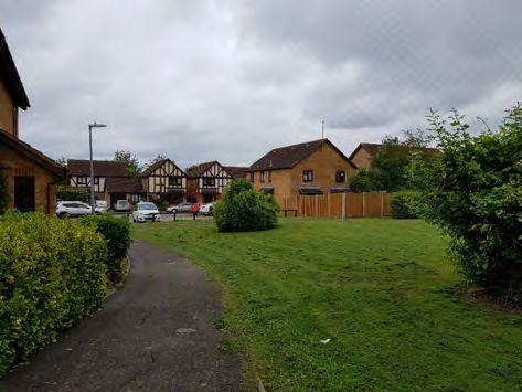
Yaxley Urban Character Area 11: Ferndale Estate
Mixed housing types, colours and materials along Ferndale Road. Telford Drive has several examples of houses influenced by arts and
Trees and hedges form a key element of the character of this area crafts and interwar style
15.68 The Ferndale Estate is a large character area located to the north of Broadway. It was built during the
early 2000s on the site of the former Co-op Farm. This area extends northwards to the boundary with
Peterborough City Council and in the north east corner have crossed the boundary. Only those elements
that fall within Huntingdonshire District Council are included in this assessment.
15.69 The building type found within this area is 3F with a cul-de-sac layout predominating resulting in a more
irregular pattern of plot layout and sizes than in earlier forms of development. The principal road throughout
the area is Ferndale with access to the west from London Road via Brunel Way and to the south from
Broadway via Diamer Avenue. Street names are grouped into the themes of automobiles and engineering,
for example Ford Close, Royce Close, Morris Court and Edison Drive.
15.70 The land uses within the area are mixed. To accompany the approximately
600 or so homes, there is a superstore and Fourfields Community Primary
School. These complement the neighbouring residential use and provide
additional services to support the growth of Yaxley. Both are located on the
eastern side of the development accessed via a roundabout on Daimer
Avenue. These demonstrate building type 5D and 7C and add diversity to the
materials and colours. The school is a collection of single storey buildings,
play equipment and play space while the superstore has a substantial car park
set behind some boundary planting. The developments north of Broadway Co-Operative on Bentley Avenue
also provide various play areas and amenity spaces for residents. The largest is Queen's Park recreation
ground with a pavilion and several playing pitches. Adjoining this is also a substantial grouping of tree
planting providing a natural and green setting and a break amongst the extensive residential development
in this area. Throughout the area, trees and hedges form a key element of the street scene.
15.71 Housing is typically large detached family homes with on plot parking and either low boundary walls or
hedges clearly separating public and private space. The materials and colour palette vary from red and
buff brick, pantiles, grey tiles, some mock Tudor panel designs and rendering. Some have attempted to
reflect the interwar and arts and crafts style rooflines and characteristics into their design to provide a
sense of place and linkage to the earlier examples of development found on Broadway. This
provides diversity to the housing stock within the area and local landmarks.The road layout is in a cul-de-sac
style with connections made to earlier development to increase permeability and integrate these
developments.
510You can also read