Hydrogeochemical assessment of mine water discharges from mining activity. Case of the Haut Beht mine (central Morocco)
←
→
Page content transcription
If your browser does not render page correctly, please read the page content below

AIMS Environmental Science, 8(1): 60–85.
                                                    DOI: 10.3934/environsci.2021005
                                                    Received: 13 January 2021
                                                    Accepted: 26 February 2021
                                                    Published: 08 March 2021

http://www.aimspress.com/journal/environmental

Research article

Hydrogeochemical assessment of mine water discharges from mining
activity. Case of the Haut Beht mine (central Morocco)

Maryem EL FAHEM1,2,*, Abdellah BENZAOUAK3, Habiba ZOUITEN1, Amal SERGHINI2
and Mohamed FEKHAOUI2
1   Faculty of Sciences, Laboratory of Biodiversity, Ecology and Genome, Mohammed V University
    in Rabat, Morocco
2   Scientific Institute, GEOPAC Center, Mohammed V University in Rabat, Morocco
3   ENSAM, laboratory of spectroscopy, molecular modeling, materials, nanomaterial, water and
    environment, Mohammed V University in Rabat, Morocco

* Correspondence: E-mail: maryem.elfahem@gmail.com; Tel: +212610459728.

Abstract: The rocks are likely to give a geochemical signature to the groundwater circulating there.
Therefore the hydro geochemistry of the mine’s water is influenced by the mining method. The
continuous pumping of the mine water gives discharges that induce harmful impacts on the
environment. The Sebou basin is subjected to strong industrial and urban pollution, but in the
literature, the evaluation of the mining impact on this area is neglected. This paper is dedicated to
this issue and as part of the evaluation of the mining impact on the Sebou watershed, the haut Beht
mine was chosen among the four mines which include the watershed, and then we proceeded, as the
purpose of this work, to evaluate the physicochemical quality of this mine’s water discharges and
their metallic trace elements (MTE) load (As, Pb, Cd, Zn, and Cu) through monitoring of four
locations during two analysis campaigns in 2014 and 2015. This monitoring was performed by
ICP-MS analysis. The results showed absenteeism of the acidic nature of mine’s water,
characterizing acid mine drainage (AMD). The majority of the analyzed water presents important
concentrations of sulfate. During the 2014 campaign, the examination of trace metal element
concentrations showed, at station 2, contamination of Iron, Aluminum, Manganese and, Arsenic.
However, the concentrations of Pb, Cd, Zn, and Cu elements remain conform and very low compared
to the limit of standards. The monitoring of the overtake elements made it possible to identify the
degree of contamination of the mine’s water discharges and to note an improvement in time in the
mine water discharges quality.
61

Keywords: Sebou River; Environment; metallic trace elements; mine water; discharges

1. Introduction

      The interest of evaluating the impacts of mining and its wastes on the environment did not arise
until the 1990s. This interest required, in several countries, the implementation of mining activities
regulations to limit the risks of pollution and to preserve natural ecosystems. Like in other countries,
the mining sector in Morocco has found itself confronted with this environmental issue. The mining
regulations (law 33-13) aim to set a range of new conditions for mining, taking into account the
environment parameter during all phases of exploitation and post-mine. However, the problem of old
mines exploited and abandoned without rehabilitation still remains [1,2].
      Mining generates negative impacts on the environment as a result of direct or indirect effects
during activities and/or after the closure of the mine [3,4]. Freshwater basins are the most affected
element by such activities due to the water usage for the ore treatment and mine water discharges [4].
Thus, mines are increasingly threatening the water resources on which the whole ecosystem depends.
Water is then considered as a "victim of mining" [5]. Metals are omnipresent in surface and ground
waters, and their concentrations are generally very low, hence comes the name "metallic trace
elements (MTE)". Mineral deposits are concentrations of metallic or other mineral commodities in
the Earth’s crust that result from a variety of complex geologic processes. The natural weathering
and erosion of a mineral deposit at the Earth’s surface disperse their constituents into the waters,
soils, and sediments of the surrounding environment [6,7]. Thereby, the exploitation of a deposit rich
in metals generates a change in terms of the quality of the water in contact with the mining works [8].
Around the world, several previous studies have been devoted to the problem of the abandoned
mines’ impact on the environment [2,9–17]
      The present work falls within the general perspective of understanding the pollutants behavior
and the metallic trace elements mobility in the mining environment, through the diagnosis of the
current contamination situation and its evolution over time. The aim of the work is to ensure the
protection of the environment against the nuisance caused by mining activity in the study area. The
haut Beht mine is located at the Beht watershed which is part of the Sebou watershed (sub-basin)
(Figure 1). The Sebou River drains one of the main watersheds of Morocco in terms of water
resources. However, it is subjected to a strong pollution [18–21]. The waters of Sebou have been
experiencing a significant deterioration in their quality for several years, due to domestic and
industrial discharges [22–25]. The Sebou watershed contains 13.3% of the country's industrial units,
7% of which are located in the Fez region, 3.2% in the Meknes region, and 3.1% in the Kenitra
region [18]. In several previous studies, water pollution in the sebou basin and its sub-basin Beht has
been treated, among these studies we can cite [18–24]. for the Sebou and [25–28]. for The Beht, but
to our knowledge there is no study that has been dedicated to the evaluation of the mine water
discharges quality and their impact on the environment like this work.
      The purpose of this work is to evaluate the physicochemical quality of the Haut Beht mine
water discharges and their metallic trace elements (MTE) load (As, Pb, Cd, Zn, and Cu) through
monitoring of four stations during two analysis campaigns in 2014 and 2015. The mine water which
is considered in other studies as natural mine discharges, because when the continuous pumping of
the water from the mine stop in the abandoned mines, its mine water infiltrates and becomes more
AIMS Environmental Science                                                       Volume 8, Issue 1, 60–85.
62

charged in the mine, achieving by gravity the underground waters and contaminating it by heavy
metals. The mine water discharges are originally from the mine, and they are different from those
coming from the mine tailing dam which is treated in several studies as the only mine’ discharge. The
evaluation of the mine water load in trace metal element and other analyses in this work are
elaborated in the world for cases of sustainable management of mine water discharges and the
reduction of their environmental impacts, or in the context of the performance monitoring of a
treatment station of mine water discharges, or for post-mine monitoring and impact assessment
(Table2).

2. Materials and method

2.1. Presentation of the study area

2.1.1. Geographic and hydrological context

      The study area is in the Beht watershed (sub–basin of the sebou watershed: The watershed of
the river Beht is located northwest of Morocco and occupies the southwestern part of the Sebou
basin), which is bounded on the north by the Gharb plain and the Meknes plateau, on the south by
the Oum-Erbia basin, on the west by the Bouregreg watershed and on the east by the Middle Atlas,
which occupies the southwestern part of the Sebou watershed in northwestern Morocco [29]. The
administrative territory of the Beht watershed overlaps contains five provinces and twenty-six Rural
Communes (Figure 1). The study area has a mountain character, and does not contain a generalized
groundwater table. The water resources of the localized water tables are used in the form of springs
or by wells in the alluvium by the local populations for the irrigation of small plots or the supply of
drinking water. In addition, there are alluvial aquifers along the Beht river where small perched
aquifers with low flow rates are found. The HBM mine is located on the boundary of Beht river, The
main affluent of the Sebou river, and its two affluents 1 and 2 (Figures 1 and 3). The Sebou
watershed covers an area of 40,000 km2 located between the meridians 3°50' and 6°40' W and the
parallels 33°and 35° N. This watershed, which includes 1/3 of Morocco's surface water resources, is
drained by the Sebou river that originates in the Middle Atlas and travels about 500 km before
reaching the Atlantic Ocean near Kenitra [30]. The watershed of Sebou is the richest in terms of
water resources in Morocco, with water supplies of the basin amounting to more than
5 billion m3/year, and it is one of the regions with the most important potential of irrigable and
irrigated lands and industries at the national level. All these activities affect the quality of waters in
this basin and cause more or less significant changes to the living communities [22,24,31].

AIMS Environmental Science                                                         Volume 8, Issue 1, 60–85.
63

      Figure 1. Geographical location of the study area: the Beht watershed in the context of
      the Sebou watershed [25].

2.1.2. Geological and hydrogeological context

      From a geological point of view, the mine studied is located in the north-eastern part of the
massif of central Morocco, which is a northern zone of the western Meseta [32,33]. This zone
consists essentially of a Neoproterozoic substratum (acid or intermediate lava and low flush
granites) [34,35], a Paleozoic cover (Cambrian to Permian age) and sedimentary and volcanic
Meso-Cenozoic cover [2,32,33,35,36]. The main Paleozoic formations of the mine are:
micro-conglomeratic schist, Ordovician quartzite (Ashgill), and Black Silurian graptolite shale
(Gothlandian) [37,38]; yellow tentaculite schist is associated with sandstone banks and Devonian
seedy limestone formations [38] (Figure 2). The mine is located in a dislocation zone of the
Smaala-Oulmes (NE-SW) major fault, which ends at the NE with several branches of the same
direction and shows NNE-SSW branches [38–41]. The system of this fault is truncated further to the
north by the Tafoudeit accident overlapping the Namur formations and the Visean lands [37,38,42].
      The mineralogical study in different areas of the massif of central Morocco made it possible to
distinguish different types of ores, as breccia pyrite brecciated ore, massive ore with pyrrhotite,
pyrite milky ore, and ribbon ore with pyrrhotite and chalcopyrite. The mineral paragenesis is
dominated in some areas by pyrrhotite (more than 90%) with pyrite, chalcopyrite, magnetite, and
glaucodot (Co, Fe) which are all associated. On the other hand, sphalerite, galena, and arsenopyrite
are present in accessory quantities [43–48]. The regional geological framework has given mineral
richness to the Sebou watershed, which includes four deposits (active and abandoned) [2,49,50].
      The study area does not contain a generalized groundwater table. The water resources of the
localized water tables are used in the form of springs or by wells in the alluvium by the local

AIMS Environmental Science                                                     Volume 8, Issue 1, 60–85.
64

populations for the irrigation of small plots or the supply of drinking water. In addition, there are
alluvial aquifers along the Beht river where small perched aquifers with low flow rates are found.
Taking into account the predominance of schistose and marl formations that form the watershed of
the Beht river, it seems certain that the Groundwater availability in the Beht Basin remains very low.
The existence of some auriferous rocks, with low water productivity and very limited extension, is
mainly related to secondary modifications affecting the initially impermeable formations, to which
are added appropriate structural forms (faults) [51].

      Figure 2. Geological map and structural domain of the Moroccan Hercynian central
      massif [52].

2.1.3. Climatic context

      From a climatic point of view, the mine is located in the Beht watershed, the region's climate is
a Mediterranean type with oceanic influence and becomes continental inland [25]. It is manifestedby
rainy winds coming from the west and decreases in precipitation away from the sea and in protected
valleys like those of Beht or high Sebou before increasing rapidly on the slopes of the Rif. These
influences of altitude, latitude, and exposure are combined to form a local microclimate where cold,
frost, snow, and winter rains can oppose summer heat and thunderstorms [53,54]. The rains are
poorly distributed throughout the year and very irregular from one year to the next. Average annual
temperatures in the watershed range between 15 °C and 19 °C depending on altitude and
continentality summer temperatures are high, the hottest months are July and August with average
highs of 34 to 36 °C and the coldest months are December, January and February. The average of the
minima is 3 to 7 °C [29]. The annual average rainfall in the basin is 600 mm on average with a
maximum of 1000 mm on the heights further northward and a minimum of 300 mm [53].
AIMS Environmental Science                                                       Volume 8, Issue 1, 60–85.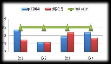
65

2.1.4.   Soil type

      The soil cover of the Beht watershed is essentially characterized by soils whose chemistry is
dominated by the presence of varying amount of alkaline earth (calcium and magnesium) because of
the limestone backbone of the area [55]. The lands of the Beht watershed are limestone clay-loam in
nature, the upper horizons of which are relatively rich of organic matter. They are formed on the
recent and sub-current alluvial deposits of the Beht river. The porosity is medium, and the
compactness is quite high. Structural stability of water is precarious, and under the effect of excess
water (irrigation, rain), the upper horizons become crusty (beating soil) [56].

2.2. Sampling stations

      In the context of the study of the impact of mining activity on the environment at the Sebou
watershed that we chose the haut beht mine (HBM) among the four (active and abandoned) mines
that include the Sebou watershed [2,49,50], and we proceeded to a physico-chemical characterization
of its mine’s water discharges and an assessment of their load in metallic trace elements and their
potential and punctual impact on the environment, through two sampling and analysis campaigns, in
2014 and 2015 at the four discharge points of the mine's water.

            Figure 3. Map of the location of the study area and the four sampling stations.

     The sampling stations were chosen to assess the physico-chemical quality and the trace metal
load of the mine's water discharges. At the four selected stations, four water discharge samples were
taken during two sampling and analysis campaigns carried out in 2014 and 2015 (Figure 3).
    • Station 1: (Ex 1): the water discharge of the station 1 is located upstream of all other
        discharge points on the Beht river.
    • Station 2: (Ex2): the water discharge of the station 2 is located downstream the station 1
        (Ex1) on the Beht river.
    • Station 3: (Ex3): the water discharge of the station 3 is located upstream of the discharge
AIMS Environmental Science                                                       Volume 8, Issue 1, 60–85.
66

            point of Ex4 on the same affluent of the Beht river, affluent 1.
       •    Station 4: (Ex4): the water discharge of the station 3 is located downstream the discharge
            point of Ex3 on the same affluent of the Beht river affluent 1.

2.3.       Methods of analysis

     The mine water discharges samples were taken in 2014 and 2015 at the four sampling stations.
Sterilized polyethylene vials were used for sampling, and each sample was taken to avoid the
degassing of the sample, then to do this each bottle is filled gently while minimizing the effects of
turbulence. Hermetically sealed, sample vials are stored at 4 ° C for rapid transport to the analytical
laboratory in order to avoid changes in chemical composition due to degassing and photo-lytic or
microbial reactions. Water discharges samples were acidified by the addition of 4% nitric acid to
avoid changes in MTE concentration.
     Following standardized methods (Table 1), 19 variables were monitored physico-chemically,
including two in situ (pH, temperature).
     The heavy metal analyzes were performed by ICP-MS (inductively coupled plasma mass
spectrometry), which is a highly sensitive technique with detection limits up to part per trillion (ppt)
(ng / l), for monitoring the evolution of the metal charge of water discharges in five particular
elements: Lead (Pb), Zinc (Zn), Copper (Cu), Cadmium (Cd) and Arsenic (As).
     The two sampling and analysis campaigns of water discharges (C1: 2014 campaign and C2:
2015 campaign) were carried out by a state-approved laboratory. The samples were taken following
the AFNOR standard NF EN 25667 (ISO 5667) (table 1).

           Table 1. The references of the basic analytical methods adopted by the analytical laboratory.

TESTS                             REFERENCE METHODS               TESTS      REFERENCE METHODS
Accredited tests in chemistry     Accredited tests in chemistry
pH                                NF T 90-008 / NMISO10523        As         FD T 90-119
T °C                              NF EN 25667 (ISO 5667)          As         NF EN ISO 11885
                                  /NM 03.7.008
Sulfates                          NF T 90-040 / NM ISO 9280       Al         NF EN ISO 11885
Pb                                FD T 90-112                     Al         FD T 90-119
Pb                                FD T 90-119                     Zn         FD T 90-112
Pb                                NF EN ISO 11885                 Zn         NF EN ISO 11885
Cd                                NFENISO5961                     Cu         FD T 90-112
Cd                                NF EN ISO 11885                 Cu         NF EN ISO 11885
Fe                                FD T 90-112                     Cr         NF EN1233
Fe                                NF EN ISO 11885                 Cr         NF EN ISO 11885
Mn                                NF EN ISO 11885                 Sb         NF EN ISO 11885
Mn                                FD T 90-112                     Ni         FD T 90-119
Co                                NM 03-7-022                     Ni         NF EN ISO 11885
Co                                NF EN ISO 11885                 Se         NF EN ISO 11885
Sn                                NF EN ISO 11885                 Se         Se FD T 90-119
Ag                                NF EN ISO 11885

AIMS Environmental Science                                                          Volume 8, Issue 1, 60–85.
67

3. Results and discussion

3.1.     Physicochemical characterization and metallic load of the mine water discharges

      The exploitation of deposits rich in sulfides [43–46,57] expose rocks to the action of air and
water which together have a strong oxidizing power. Oxidation of pyrite, and other associated
primary minerals in sulfide deposits, results in mine water characterized by significant amounts of
sulfates and dissolved heavy metals. [58]. The heavy metals chosen in this study are linked to
sulfides because the arsenopyrite is the main source of arsenic (As), the Chalcopyrite contains most
of the copper, the Zn and Cd are in sphalerite [8,59], and since the native lead (Pb) is rare, and due to
its chalcophile nature, it is associated with sulfide deposits [8,47,48].
      All of the analysis’ results of the eight samples of the mine water discharges collected during
the 2014 and 2015 campaigns were compared with the general limit values for discharges into
surface or underground water. The analysis of the results obtained made it possible to identify the pH
variability, which is a feature key of acid mine drainage (AMD), as well as the elements in excess
and the elements relating to the metallic load of water discharges, in particular lead ( Pb); Zinc (Zn);
Copper (Cu); Cadmium (Cd) and Arsenic (As).

3.1.1.    pH

    The pH varies between 7.6 and 8.35 during C1 and between 7.6 and 8.2 during C2 (Figure 4).
The upstream/downstream spatial distribution of the sampling stations shows a low variability of the
pH values recorded during the C1 and C2 campaigns.

         Figure 4. Evolution of the mine water discharges pH during the C1 and C2 campaigns.

     The mine water discharges have a neutral to slightly alkaline pH (7< pH
68

contained in the water, which causes further changes in pH concentrations [61]. This seasonal
variation in the mine water pH concentration can also be related to the rainfall conditions of the
sampling period, because during a heavy rainy event the mine water records a supply of meteoric
origin water. This water is very weakly mineralized with a rather acidic tendency (pH of rainwater
between 6 and 6.5), which causes the drop of the mine water pH concentrations [62].
     This neutral to basic character of the mine water can be explained by the fact that the AMD
phenomenon is not encountered in all sulfide mineral mining operations, especially when mineral
phases in the bedrock are able to neutralize the acidity produced [45,57]. With the presence of
carbonate, the acidity produced is neutralized by the dissolution of carbonates witch greatly slow the
solubilization rate of contaminating metallic trace elements. It is a neutral mining drainage
(NMD) [63]. The capacity of the sulfides to produce acid is determined by the relative content of the
acid-generating mineral phases and the acid-consuming phases; if the acid consuming such as calcite
and bauxite are present, the resulting water can be neutral pH containing high concentrations of
sulfate and metals [64]. In the geological context of the studied area, the presence of carbonate
minerals such as calcite, promotes a natural neutralization in situ of the acidity of the mine water
discharges by producing a NMD [65,66].

3.1.2.     SULFATE

     The sulfate contents vary during the C1 between 131 mg/L recorded at the station Ex 3, and
1413 mg/L recorded at the station Ex 4, and between 131 mg/L at the station Ex 1 and 1310 mg/L at
the Ex 4 station during the C2 (Figure 5). The station Ex3 shows the two lowest sulfate
concentrations noted in both C1 and C2 campaigns with a slight increase in C2. However, the station
Ex 4 shows the two highest sulfate concentrations recorded during both C1 and C2 campaigns, with
a significant decrease in C2.
     All sulfate concentrations recorded at the mine water discharges during the C2 are lower than
those recorded during the C1, except on the station Ex 3. The sulfate values recorded at the totality of
the mine water discharges sampling stations exceed the limit value of the industrial discharges set at
500 mg/L, except on the station Ex 3, which represents lower concentration to the standards during
the two analysis campaigns (Figure 5).

         Figure 5. Evolution of sulfate content of the mine water discharges during the C1 and C2
         campaigns.
AIMS Environmental Science                                                        Volume 8, Issue 1, 60–85.
69

      The high concentration of sulfate in the mine water discharges is mainly related to the
exploitation of sulfide ore [66] due to the oxidation of the mineral sulfides by producing heavy
metals and sulfate [67].
      The variation in the sulfate contents between C1 and C2 at the Ex1 and Ex2 stations is linked to
the progress of the underground mining works, because the geochemical background changes and
induces the modification of the mineralization of the mine water discharges. The increase of the
depth of the exploited levels induces the decrease of the sulfate contents because the high sulfate
contents characterize the water circulating through shallow mining works [61,68–70]. The factor of
the contact time of the mine water discharges with sulfide rocks at the mine (residence time in the
mine) can also be a determining factor for the sulfate concentrations in the mine water discharges,
because sulfates come from the oxidation of pyrites at the contact of water and air [61,71].
      Furthermore, the sulfate concentration recorded in the station Ex 3, which does not exceed the
industrial waste limit values during the C1 and C2 analysis campaigns, is probably related to the
dilution phenomenon, since the final discharges sampled in this station are composed of the mixture
of mine water used for mining and a large part of the dewatering of the deposit which has a
significant water wealth. The discharges rate at this station accounts for more than the half of the
mine's water discharges.

3.1.3.     ALUMINUM

     Aluminum concentrations show a very low variation during the C2. However, during the C1,
the values recorded at the four measurement stations are less than 1.5 mg/L, except on the station Ex
2, which has a value of 14.1 mg/L, which exceed the limit value of the industrial discharges in the
surface and underground waters setting the threshold value at 10 mg/L (Figure 6).

         Figure 6. Evolution of the aluminum content of the mine water discharges during the C1
         and C2 campaigns.

     Aluminum is the second most abundant metal in the earth after iron [72]. The origin of
aluminum in the mine water discharges can be linked to the geochemical alteration of rocks in
contact with water and oxygen during mining it corresponds to total hydrolysis, which results in the
release and drainage-driven elimination of minerals constituents. It should be noted that iron and
aluminum oxyhydroxides are insolubilized. This alteration leads to the formation of newly formed
AIMS Environmental Science                                                      Volume 8, Issue 1, 60–85.
70
clays, which can induce an increase in the turbidity of the mine water discharges circulating through
the mine. Thus, the turbidity of the mine water discharges can be a determining factor of the high
aluminum content recorded at point Ex2 during C1, because the increase of the turbidity induces an
increase of the aluminum concentration in the mine water [73]. The high aluminum content at point
Ex2 during C1 can also be linked to the pH of the mine waters, because the solubility of aluminum is
low in waters with a pH close to neutrality between 7 and 7,5, while the precipitation of aluminum
requires a pH greater than 5 [73,74].
Also, the aluminum can be related to the natural erosion phenomena of the mountain, because it
comes mainly from the mechanical training of alumino-siliceous minerals, which are easily
mobilized, present in amorphous gels (allophanes type) and / or watershed clays [75].
3.1.4. IRON
The iron concentrations recorded at the mine water discharges during the C2 are lower than
those recorded during the C1, except at the station Ex 1 (Figure 7). Like aluminum, the iron
concentrations recorded during the C1 and C2 analysis campaigns are below the limit recommended
by the limit values of industrial discharges in surface or underground waters fixed at 5 mg/L, except
at the station Ex 2, which represents a value of 25.5 mg/L during the C1, far exceeding the limit
value.
Figure 7. Evolution of the iron content of the mine water discharges during the C1 and
C2 campaigns.
During the mining of a massive rock containing sulfide minerals, the pumping of the mine’s
dewatering in the surrounding lands an area that was previously saturated, which put the sulfide
minerals in contact with the oxygen and the water of percolation. This induces the alteration of all
readily oxidizable minerals, through the formation of sulfates and hydroxides, carbonates and other
oxygenates characteristic of what is called the oxidation zone of mineral deposits. The Pyrite, which
is the most widespread sulfide in the earth's crust, oxidizes to ferrous sulfate which, in the presence
of free oxygen, is transformed into ferric sulfate [75]. This could explain the high concentration of
Iron at the station Ex 2 because the deposit 2 is rich in pyrite [19,57,65,66,76].
AIMS Environmental Science Volume 8, Issue 1, 60–85.71
3.1.5. MANGANESE
The Manganese concentration recorded values indicate an irregular contamination. Indeed, they
vary, at the 4 stations, between a minimum value of 0.003 mg/L recorded in the station Ex 3 during
the C2 and a maximum value of 8.78 mg/L noted in the station Ex 2 during the C1, thus exceeding
the limit value fixed at 1 mg/L. Seasonal variability is recorded at the station Ex 1, which has a
concentration of 0.075 mg/L during the C1 and a concentration of 7.35 mg/L during the C2 (Figure
8).
Figure 8. Evolution of the Manganese content of the mine water discharges during the
C1 and C2 campaigns.
Like iron and aluminum, the high concentration of Manganese at the station Ex 2 during the C1
and at the station Ex 1 during the C2 can be related to the oxidation of pyrite [19,57,76], following
the percolation of the mine’s water through the mining cavities of sulfide lands [75].
The remarkable decrease in the concentration of aluminum, iron and manganese at the station
Ex 2, between the C1 and C2 campaigns is due to the change of the geochemical background, this is
being the case because when the depth of the mine increases the water circulates deeper in the mine,
and its overall mineralization changes [61,70].
3.1.6. ARSENIC
The arsenic values recorded at the totality of the mine water discharges sampling stations do not
exceed the limit values of industrial discharges in surface or underground waters set at 50 μg/l,
except in the Ex 2 station which had a concentration above the standard during the C1. During the
C1, they show significant variability from downstream to upstream of the mine, which varies
between 83μg/l and 2.5μg/l at the Ex 2 and the Ex 1 stations respectively (Figure 9).
However during the C2, the variation of the arsenic contents is less important with values much
lower than those recorded in the C1, and which vary between 25μg/l at the station Ex 3 and 3,6μg/l at
the Ex 1 and Ex 4 stations.
AIMS Environmental Science Volume 8, Issue 1, 60–85.72
Figure 9. Evolution of the Arsenic content of the mine water discharges during the C1
and C2 campaigns.
The arsenic ultimate source in the mine waste is the primary arsenopyrite in the ore concentrates.
Arsenic is commonly associated with metallic mineral deposits. While arsenic is naturally mobilized
from these deposits, mining and beneficiation of the deposits can significantly amplify arsenic
mobilization. Once the ore has been excavated, processed, and discarded in waste rock piles and
tailing, percolating rainwater can facilitate oxidation and dissolution of arsenic from the mine wastes
and mine excavations. Dissolved arsenic can then be discharged into the environment with
potentially toxic consequences for the downstream biota. Mining and tailings disposal promotes
oxidative arsenic mobilization by increasing permeability and increasing contact between arsenic
sulfides and oxygenated water. Hence, anthropogenic interference accelerates the natural processes
of arsenic mobilization and dispersal into streams.
Arsenic is initially present in sulfide compounds such as arsenopyrite (FeAsS), orpiment
(As2S3) or realgar (AsS) [77–81]. The arsenic contents in the waters vary according to the lithology
crossed, the climate and the anthropic contribution [79]. And since it comes in different chemical
forms (like many other elements), its speciation depends on the pH and the redox potential [82,83].
The visible decrease in the concentration of arsenic at point Ex 2 during C2, is probably linked
to the decrease in the concentrations of Fe, Al and Mn in the mine water discharges of this point,
because the oxyhydroxides of these elements constitute alongside clays and organic matter a
significant fraction of the arsenic trapping during the weathering which plays an important role in
controlling the concentration of dissolved arsenic [84–89].
3.1.7. LEAD, CADMIUM, COPPER, AND ZINC
The levels of lead, cadmium, copper and zinc recorded at the totality of the mine water discharges
sampling stations, have a small spatial and temporal variability (Figure 10). They remain very low
and do not exceed the limit values for industrial discharges set at 1000 μg / l for lead, 200 μg / l for
cadmium, 3000 μg / l for copper and 5000 μg / l for zinc.
AIMS Environmental Science Volume 8, Issue 1, 60–85.73
Figure 10. Evolution of lead, cadmium, copper and zinc contents of water discharges
during the C1 and C2 campaigns.
In waters, lead (Pb) has a strong affinity for sedimentary particles including clays,
oxy-hydroxides of iron and manganese, sulfides and organic matter [90]. It can also be associated
with carbonates when the medium is poor in organic matter and in oxy-hydroxides of Fe or Mn [91].
While zinc (Zn) is in ionic form, it is complexed by organic ligands (fulvic and humic acids) or even
associated with inorganic colloids. In waters with pH below 8, the concentrations of zinc in the
cationic form (Zn2 +) are greater, while the neutral species ZnCO3 is predominant in waters with pH
above 8 [92]. Furthermore, the zinc is complexed with sulfates in waters with an acid pH and can
precipitate in the form of sulfated salts under extreme acid conditions [93,94]. For the Cadmium (Cd)
in waters and pH value below 8, it is present in the dissolved state as Cd2 + form, preferentially
complexed by humic substances [95]. And in an anoxic environment, it precipitates with S2- even at
very low concentrations [24].
In waters the copper (Cu) is mainly found in divalent form Cu (II), while the monovalent form
Cu (I) is present only at extremely low concentrations since it reacts to form metallic copper and Cu
(II) ions. Cu (I) can be produced under reducing conditions and the majority of the compounds
formed are insoluble [96,97].
The Copper in complexed form is associated with inorganic and organic ligands. This
complexation of Cu by organic ligands strongly conditions its bioavailability, because the organically
complexed copper is very stable [98]. The metallic cations (Pb, Zn, Cu and Cd) generally show low
AIMS Environmental Science Volume 8, Issue 1, 60–85.74
concentrations in the waters of mining lakes when the pH is alkaline [99]. This is the case of the
HBM mine water discharges, which is located in limestone soils [38,55] where acidic waters are
quickly neutralized by carbonates, and where most metals become insoluble and precipitate [100].
3.2. National studies
In morocco, currently there are active mines producing a variety of mineralization processes,
and there have been many closed and abandoned mines since the 1970s. Recently, some studies have
been interested in the environmental impact of abandoned mines and sites as well as the recovery of
their waste. Let us cite those of [101] and [102], on the Kettara mine and [103] on the Sidi Bou
Othmane mine in the Jebilet; we can also refer to those carried out in Haute-Moulouya [104–107]., in
central Morocco on the Tighza mine [108], on the Mohammedia salt mine [109] and on the Jerrada
mine [110]. The studies on zones near the mining centers of Aouli and Mibladan in Haut Moulouya
have shown a negative impact of mining activities, especially the contamination of surface water,
sediments, soil and plants [63,106,111,112], as well as pollution by heavy metals of surface water of
Moulouya river [100,113].
The evaluation of the physico-chemical quality and the MTE load of the mine water discharges
is an inseparable part of the evaluation of the impact of mining on the environment, because it can be
indicative of the origin of any metal detected in excess in surface water, groundwater or sediments
surrounding mines. However in most of the environmental impact studies the mine water discharges
are considered as natural waters discharges from the mine, however the drainage of this water
through the mine cavities can induce their load in MTE., which can have an impact on the
environment once this mine water is discharged or infiltrated into the underground water.
Table 2. Comparative table of the average concentrations of metallic trace elements in
the HBM water discharges and in the mine water discharges of other mines in Morocco.
Average MTE concentrations (µg/L) Industrial site Study area Exploited Reference
Pb Cd As Cu Zn substance
Mine water 23, 17 1, 4 23, 87 53, 81 131, 67 HBM Sebou watershed n. d This Work
discharges
Mine lakes 27, 5 n. d 92,825 n. d n. d Zeïda Haute Pb [111]
Mine Moulouya
drainage water n. d n. d n. d 58000 45000 Kettara Mine Kettara River Jebilet Fe-S [102,116,117]
Mine lakes 31, 186 n. d 111, n. d n. d Zeïda Mine Haute Moulouya Pb [63]
202
Leachate of 306, 875 9, 125 763 100686 8597 Kettara Mine Kettara River Fe-S [115]
mine tailing Jebilet
n. d.: Undetermined value
In Morocco, in the majority of the impact of mining on the environment evaluation studies, the
physico-chemical characterization and the evaluation of the contamination in MTE are focused on
the evaluation of the water quality and sediments surrounding mining sites. In such studies, the
designation of mine discharges is attributed to all liquid or solid mine discharges (spoil tip; dumps;
AIMS Environmental Science Volume 8, Issue 1, 60–85.75
ore processing residues; water from quarry lakes and infiltration at the foot of the tailings dam). As
an example of the studies characterizing the quality of solid discharges from the mine or the ore
processing plant, we can cite the work on the Tourtit and Ichoumellal mines [2], the Zeïda, Mibladen
and Aouli mines [106,113], the Sidi Bou Othmane mine [103], the Kettara mine [101,102,114,115].
Since we are interested in the HBM mine water discharges, in our study the concentrations of
metallic trace elements evaluated in this study were compared with some national studies (Table 2),
which are concerned with the evaluation of metallic trace elements in mining areas and their
concentrations in mine liquid discharges [63,102,111,115–117]:
The origin of the waters and their course define their hydro-chemical character and, hence the
difference in MTE contents in mine liquid discharges compared to the levels in the HBM mine water
discharges.
In the case of the Zeïda mine, water is sampled at the level of the mining lakes, which is located
at the foot of the spoil tip and the tailings dam. The arsenic and lead concentrations are higher than
the levels recorded in HBM's mine water discharges. These discharges have a common character
with the waters of the mining lakes of Zeïda which is the neutral pH to slightly alkaline influencing
the solubility of the MTE due to the fact that the metallic trace element (Pb, Zn, Cd, Cu, ...) show
high concentrations in acid mining lakes, while the MTE (As and Se) are generally at high
concentrations in alkaline mining lakes [63,99].
For the drainage water from the kettara mine, samples were taken from various pits collecting
runoff water of the tailings pond and runoff water of the waste rock [102,116,117]. These drainage
waters have much higher copper and zinc contents than those recorded in the HBM mine water.
The leachate of the kettara mine tailings are obtained by mixing 150 g of tailings with 300 ml of
distilled water (Ratio 1/2), with permanent agitation, and after a week, the filtration was carried out,
then the measurements of the concentrations of MTE in the leachate water, these analyses show that
the As and Pb contents are higher at the top of the pile of mining residues, which can be explained by
the acidic pH on the surface of the pile of mining residues in direct contact with the oxygen. The
values recorded in As, Pb, Cu, Cd and Zn at the leachate of the tailings of the kettara mine are much
higher than those recorded at the HBM’s water discharges.
The MTE concentrations in the HBM water discharges are the lowest compared to other liquid
discharges from other mines, something which can be linked to several factors, including: the
geochemical background of the mine, the waters contact time with the rocks, the nature of the
residues that the water percolates through and finally the pH of the water which plays an important
role in the degree of passage of the MTE in the aqueous phase.
3.3. International studies
The concentrations of metallic trace elements evaluated in this study were compared with some
international studies (Table 3), which are concerned with the evaluation of metallic trace elements in
mining areas and their concentrations in mine water discharges [118–120].
The average concentration of lead (Pb) recorded in the HBM water discharges is lower than the
one noted in the mine water discharges of the abandoned Escarro mine in France, which was
exploited between 1960 and 1991, according to the environmental impact study of the Escaro's mine
developed in 1983 [118]. In terms of lead, the average concentration in the HBM mine’s water is in
second class after that of the Escaro mine, then in third class that of the Malines mine in France, and
AIMS Environmental Science Volume 8, Issue 1, 60–85.76
in the last class that of the Soughs mine in England.
Table 3. Comparative table of the average concentrations of metallic trace elements in
the HBM water discharges and in the mine water of four other active and abandoned
mines worldwide.
Average MTE concentrations (µg/L) Industrial Study area Exploited Reference
Pb Cd As Cu Zn site substance
Morocco Ex1 (C1) 61 1,1 2,5 4,2 190 HBM Sebou watershed n.d This work
Ex1 (C2) 5, 6 0, 5 3,6 2 115
Ex2 (C1) 72 8, 3 83 406 528
Ex2 (C2) 1, 7 0, 2 9,3 1 ,4 2, 2
Ex3 (C1) 28 0, 3 48 3, 3 60
Ex3 (C2) 1, 7 0, 2 25 1, 4 2, 2
Ex4 (C1) 9 0, 4 16 8, 8 143
Ex4 (C2) 6, 4 0, 2 3, 6 3, 4 13
Average 23, 17 1, 4 23, 87 53, 81 131, 67
France 29 n. d. 2, 14 5 9, 28 Escarro Languedoc Roussillon CaF2 [119]
mine Têt watershed
11, 12 2, 7 n. d. n. d. 4,21 Malines Saint-Laurent-le-Minier Pb, ZnS, [118]
mine Hérault watershed PbS, Zn
England 10, 2 0, 84 n. d. 0, 56 160, 2 Soughs Derbyshire Pb [118]
mine Bugsworth watershed
Norway n. d. 12800 280 574000 5640000 Killingdal Sør-Trøndelag Cu Zn S [120]
mine Gaula watershed
n. d.: Undetermined value
For the Cadmium (Cd), the average concentration recorded in the mine water discharges of the
HBM is in third class after that of the Killingdal mine in Norway, and that of the Malines mine in
France, and in the last class that of the Soughs mine in England. In terms of Arsenic (As), the
average concentration in the HBM water discharges is in second class after that of the Killingdal
mine in Norway, and in the last class that of the Escarro mine in France.
The average concentration of copper (Cu) in the HBM water discharges is in second class after
that of the Killingdal mine in Norway, then in third class that of the Escarro mine in France, then in
the last class that of the Soughs mine in England. And for the Zinc (Zn), the average concentration
recorded in the HBM water discharges is in third class after that of the Killingdal mine in Norway,
and that of the Soughs mine in England. In fourth class that of the Escarro mine in France then that
of the Malines mine in France.
It should be noted that the physicochemical characterizations of mine waters compared to the
HBM are developed as part of studies aimed at the sustainable management of mine water discharges
and the reduction of their environmental impacts. For the rest of the mines, it is in the context of an
environmental impact study for the continuation of exploitation for the Escarro mine, and in the
context of the performance monitoring of the treatment station of mine water discharges for the
Malines mine, and post-mine monitoring and impact assessment for the Soughs and the Killingdal
mines. The differences among the average concentrations of MTE contained in the mines waters
AIMS Environmental Science Volume 8, Issue 1, 60–85.77
show the importance of the lithology of the host rock, rather than the mineralogy of the ore, for the
quality of the mine water [120].
The oxidation of sulfide minerals to release heavy metals, sulfate and acid is the fundamental
reaction characterizing acid mine drainage [60,121–123]. However, the quality of mines waters can
be adversely affected by other parameters such as the kinetic factor because of the relatively slow
rate of dissolution and oxidation of sulfide minerals compared to the rapid flux of limestone
groundwater through the mine conduits [38,55]. And the solubility of heavy metals that is suppressed
by the high alkalinity of water, as well as other parameters that may negatively influence the global
quality of mine water discharges such as the salinity, the traces of explosives based on nitrogen
oxidized to nitrates and the organic parameters [120].
The mine water discharges of the HBM are classified as one of the least charged mine water in
terms of MTE compared to other mines (Table 3).
3.4. Synthesis
The physicochemical characterization of the mine water and the evaluation of their load in
metallic trace elements (MTE) showed a small variability in time and space between the four stations
sampled, and absenteeism of the acidic nature of mine’s water. The majority of the analyzed mine
waters presents important concentrations of sulfate. During the C1 at the point Ex2 theirs is
contamination of Iron, Aluminum, Manganese and Arsenic. However, the concentrations of Pb, Cd,
Zn and Cu elements remain conform and very low compared to the limit of standards.
The monitoring of the overtake elements made it possible to identify the degree of
contamination of the mine’s water discharges, and to note an improvement in time in the mine water
discharges quality. This variation in element concentrations between the C1 and C2 campaigns is due
to the change of the geochemical background, because with the progress of the mining operations,
the geochemical background changes, influencing the hydro-chemical composition of the percolated
mine water through the walls of the mine before its rise to the surface of the ground, forming the
final discharges.
The mine water discharges of the HBM are classified as one of the least charged mine water in
terms of MTE concentration compared to other national liquid mine discharges and to other mine
waters worldwide.
4. Conclusion
The evaluation of the quality of the discharges of mine water elaborated in this study for the
first time, to our knowledge, at the level of the beht basin, sub-basin of Sebou, allowed to identify the
quality of the discharges of mine water and their load in MTE in order to evaluate the impact of these
discharges on the environment. Thus the evaluation of the mining contribution in the modification of
the quality of the environment surrounding the Haut beht mine.
The mine water remains a reservoir of contamination able to drop in the aqueous phase other
elements by the phenomenon of leaching and dredging in the wet phase. Therefore it presents a
potential toxicological risk in the absence of specific means of sustainable management aimed at
safeguarding the surrounding environment of the mine and mitigating the potential impact of the
mine water discharges into the environment.
AIMS Environmental Science Volume 8, Issue 1, 60–85.78
Despite the absence of contamination of the HBM water discharges, their pH-dependent nature
draws attention to the possibility of an MTE loading of the sediments and the waters surrounding the
mine. The potential impacts of the mine’s water discharges on the quality of groundwater, surface
water, and sediments will be the subject of other ongoing works.
The diagnosis elaborated through the analysis and the quantification of the different parameters
and their impacts, allowed to draw up a first report on the variability of the mine’s waters discharges
quality and their potential impacts on the environment.
Thus, the monitoring of environmental indicators may be essential for all industrial activity to
limit their potential impacts on the environment.
Funding sources
This research did not receive any specific grant from funding agencies in the public,
commercial, or not-for-profit sectors.
Conflict of interest
The authors declares that there is no conflict of interests regarding the publication of this paper.
References
1. Ghoreychi M, Laouafa F, Poulard F. L’après-mine et la mécanique des roches; 2017.
2. Ahmedat C, El hassani I-EEA, Zarhraoui M, et al. (2018) Potentialités minérales et effet de
géo-accumulation des éléments traces métalliques des rejets des mines abandonnées. L'exemple
des mines d’antimoine de Tourtit et d’Ichoumellal (Maroc central). Bull Inst Sci Rabat 71–89.
3. Brodkom F (2001) Good Environmental Practice in the European Extractive Industry: A
Reference Guide, with Examples from the Industrial Minerals and Gypsum Industries:
IMA-Europe.
4. Chakraborty P, Gopalapillai Y, Murimboh J, et al. (2006) Kinetic speciation of nickel in mining
and municipal effluents. Anal Bioanal Chem 386: 1803–1813.
5. McClure R, Schneider A (2001) The General Mining Act of 1872 has left a legacy of riches and
ruin. Seattle Post-Intelligencer 11.
6. Plumlee GS (1999) The environmental geology of mineral deposits. The environmental
geochemistry of mineral deposits Society of Economic Geologists Part A: 71–116.
7. Touzara S, Amlil A, Ennachete M, et al. (2020) Development of Carbon Paste
Electrode/EDTA/Polymer Sensor for Heavy Metals Detection. Anal Bioanal Electrochem 12:
644–652.
8. Salvarredy Aranguren MM (2008) Contamination en métaux lourds des eaux de surface et des
sédiments du Val de Milluni (Andes Boliviennes) par des déchets miniers. Approches
géochimique, minéralogique et hydrochimique: Université de Toulouse, Université Toulouse
III-Paul Sabatier.
9. Armiento G, Nardi E, Lucci F, et al. (2017) Antimony and arsenic distribution in a catchment
affected by past mining activities: influence of extreme weather events. Rendiconti Lincei 28:
303–315.
AIMS Environmental Science Volume 8, Issue 1, 60–85.79
10. Benvenuti M, Mascaro I, Corsini F, et al. (1997) Mine waste dumps and heavy metal pollution
in abandoned mining district of Boccheggiano (Southern Tuscany, Italy). Environ Geol 30:
238–243.
11. Galán E, Gómez-Ariza J, González I, et al. (2003) Heavy metal partitioning in river sediments
severely polluted by acid mine drainage in the Iberian Pyrite Belt. Appl. Geochem.Appl
Geochem 18: 409–421.
12. González RC, González-Chávez M (2006) Metal accumulation in wild plants surrounding
mining wastes. Environ Pollut 144: 84–92.
13. Hilton J, Davison W, Ochsenbein U (1985) A mathematical model for analysis of sediment core
data: Implications for enrichment factor calculations and trace-metal transport mechanisms.
Chem Geol48: 281–291.
14. Jian-Min Z, Zhi D, Mei-Fang C, et al. (2007) Soil heavy metal pollution around the Dabaoshan
mine, Guangdong province, China. Pedosphere 17: 588–594.
15. Luoma SN, Rainbow PS (2008) Metal contamination in aquatic environments: science and
lateral management: Cambridge university press.
16. Mlayah A, Da Silva EF, Rocha F, et al. (2009) The Oued Mellègue: Mining activity, stream
sediments and dispersion of base metals in natural environments, North-western Tunisia. J
Geochem Explor 102: 27–36.
17. Tessier E (2012) Diagnostic de la contamination sédimentaire par les métaux/métalloïdes dans
la Rade de Toulon et mécanismes contrôlant leur mobilité.
18. Azzaoui s, El hanbali m, Leblanc m (2002) Note technique/Technical Note Cuivre, plomb, fer et
manganèse dans le bassin versant du Sebou; Sources d’apport et impact sur la qualité des eaux
de surface Copper, Lead, Iron and Manganese in the Sebou.Water qual Res J 37: 773–784.
19. Benaabidate L (2000) Caractérisation du bassin versant de Sebou: Hydrologie, Qualitédes eaux
et géochimie des sources thermales. Docteur Essciences, Univ S MBA, Fès (Maroc) 228.
20. Foudeil S, BOUNOUIRA H., EMBARCH K., et al. (2013) Evaluation de la pollution en metaux
lourds dans l’oued sebou (Maroc).
21. Foutlane A, Saadallah M, Echihabi L, et al. (2002) Pollution by wastewater for olive oil mills
and drinking-water production. Case study of River Sebou in Morocco.
22. Derwich E, Benaabidate L, Zian A, et al. (2010) Caractérisation physico-chimique des eaux de
la nappe alluviale du haut Sebou en aval de sa confluence avec oued Fès. LARHYSS J ISSN
1112–3680.
23. Derwich E, Beziane Z, Benaabidate L, et al. (2008) Evaluation de la qualitédes eaux de surface
des Oueds Fès et Sebou utilisées en agriculture maraîchère au Maroc. LARHYSS J ISSN 1112–
3680.
24. Hayzoun H (2014) Caractérisation et quantification de la charge polluante anthropique et
industrielle dans le bassin du Sebou.
25. Lakhili F, Benabdelhadi M, Bouderka N, et al. (2015) Etude de la qualitéphysicochimique et de
la contamination métallique des eaux de surface du bassin versant de Beht (Maroc). Eur Sci J
ESJ 11.
26. Qaouiyid A, Hmima H, Houri K, et al. (2016) Les Teneurs Métalliques Et Paramètres
Physico-Chimiques De L’eau Et Du Sédiment De Oued Beht, Au Niveau De Sidi Kacem Et De
Oued R’dom Au Niveau De Sidi Slimane. Eur Sci J ESJ 12.
AIMS Environmental Science Volume 8, Issue 1, 60–85.80
27. Essamt F (2016) Etude de la qualitéd'eau de oued beht dans la région de Sidi Slimane.
28. Lamhasni N, Chillasse L, Timallouka M (2017) Bio-Évaluation De La Qualité Des Eaux De
Surface D’oued Beht (Maroc) Indice Biologique Global Des Réseaux De Contrôle Et De
Surveillance (IBG-RCS).
29. Abdallaoui A (1998) Contribution à l’étude du phosphore et des métaux lourds contenus dans
les sédiments et de leur influence sur les phénomènes d’eutrophisation et de la pollution: Cas du
bassin versant de l’Oued Beht et de la retenue de barrage El Kansera.
30. Bouchouata O, Ouadarri H, El Abidi A, et al. (2012) Bioaccumulation des métaux lourds par les
cultures maraîchères au niveau du Bassin de Sebou (Maroc). Bull Inst Sci Rabat 34: 189–203.
31. Kenfaoui A (2008) Economisons l’eau en la préservant de la pollution. REV HTE: 140–117.
32. Michard A, Soulaimani A, Hoepffner C, et al. (2010) The south-western branch of the Variscan
Belt: evidence from Morocco. Tectonophysics 492: 1–24.
33. PiquéA, Michard A (1981) Les zones structurales du Maroc hercynien. Geol Sci Bull Papr 34:
135–146.
34. Ouabid M, Ouali H, Garrido CJ, et al. (2017) Neoproterozoic granitoids in the basement of the
Moroccan Central Meseta: correlation with the Anti-Atlas at the NW paleo-margin of
Gondwana. Precambrian Res 299: 34–57.
35. Tahiri A, Montero P, El Hadi H, et al. (2010) Geochronological data on the Rabat–Tiflet
granitoids: their bearing on the tectonics of the Moroccan Variscides. J Afr Earth Sci 57: 1–13.
36. El Hadi H, Tahiri A, El Maidani A, et al. (2014) Geodynamic setting context of the Permian and
Triassic volcanism in the northwestern Moroccan Meseta from petrographical and geochemical
data.
37. Ben Abbou M (1990) Evolution stratigraphique et structurale, au cours du Paléozoïque, de la
bordure nord du Massif central (région d’Agourai, Maroc). Unpubl Thesis Univ Fès.
38. Izart A, Tahiri A, El Boursoumi A, et al. (2001) Carte géologique du Maroc au 1/50 000, feuille
de Bouqachmir. Notes et mémoires Serv géol Maroc.
39. Cailleux Y (1974) Géologie de la région des Smaala (Massif central marocain): stratigraphie du
primaire, tectonique hercynienne.
40. Tahiri A (1994) Tectonique hercynienne de l'anticlinorium de Khouribga-Oulmès et du
synclinorium de Fourhal. Bull Inst Sci Rabat 18: 125–144.
41. Tahiri A, Hoepffner C (1987) La faille d’Oulmès (Maroc central hercynien): cisaillement ductile
et tectonique tangentielle. Bull Inst Sci Rabat 11: 59–68.
42. Sebbag I (1970) Etude géologique et métallogénique de la région du Tafoudeit. Rapport du
Service Régional de Géologie-Meknès, service d’étude des gîtes minéraux 29: 62p.
43. Rassou KK, Razoki B, Yazidi M, et al. (2019) The vulgarization for the patrimonialization of
the kettara geodiversity (central jbilet) morocco.
44. Nerci K (2006) Les minéralisations aurifères du district polymétallique de Tighza (Maroc
central): un exemple de mise en place périgranitique tardi-hercynienne.
45. Giuliani G (1984) Les concentrations filoniennes à tungstène-étain du massif granitique des
Zaër (Maroc Central): minéralisations et phases fluides associées. Mineralium Deposita 19:
193–201.
AIMS Environmental Science Volume 8, Issue 1, 60–85.81
46. Salama L, Mouguina EM, Nahid A, et al. (2016) Apport de la modélisation géologique 3D à
l’exploration minière: Etude de cas du gisement de Draa Sfar (Jbilets centrales, Maroc) [Mining
exploration using 3D geological modeling: Draa Sfar deposit’s case study (Central Jbilets,
Morocco)].
47. Marcoux E, Belkabir A, Gibson HL, et al. (2008) Draa Sfar, Morocco: A Visean (331 Ma)
pyrrhotite-rich, polymetallic volcanogenic massive sulphide deposit in a Hercynian
sediment-dominant terrane. Ore Geol Rev 33: 307–328.
48. Rziki S (2012) Environnement géologique et modèle 3D du gisement polymétallique de Draa
Sfar (Massif hercynien des Jebilets, Maroc): Implications et perspectives de développement:
Thèse de Doctorat Présentée àla Facultédes Sciences Semlalia Marrakech
49. DEM Dddm (2011) Les principales mines du maroc. In: Ministère de l’énergie dm, de l’eau et
de l’environnement direction du développement minier, editor. Éditions du service géologique
du maroc Rabat ed.
50. Onhym Ondhedm (2020) Oulmes (sn-w) (massif hercynien central, maroc).
51. Mint chevie M (2010) Contribution à l’étude hydroclimatique du bassin versant de l’Oued Beht,
Maroc septentrional. Fès, Maroc: Université Sidi Mohammed Ben Abdellah Faculté des
Sciences et Techniques. 58 p.
52. Burger J, Dardel R, Dutrieux E, et al. (1951) Carte géologique régulière du Maroc au 1: 100.000
eme: Meknès nord, Feuille levée et édifiée par la Société Chérifiènne des Pétroles. Notes et
mémoires du Service.
53. Laabidi A, Gourari L, El hamaidi A (2014) Typologie morpho-sédimentaire des dépôts actuels
de la vallée du Moyen Beht (Sillon sud rifain occidental, Maroc). IOSR J Eng(IOSRJEN) 4.
54. ABHS AdBHdS (2013) Étude d’actualisation du plan directeur d’aménagement intégré des
ressources en eau de bassin hydraulique de Sebou. Note de synthèse, Agence du bassin
hydraulique du Sebou.
55. Duchaufour P (1977) Pédologie: Tome 1: Pédogenèse et classification: Masson.
56. Bryssine G (1966) Etude des proprietes physiques des dess de l'oued beht. Al Awamia 2: 85–
123.
57. Rachdi HE-N (1995) Etude du volcanisme plio-quaternaire du Maroc central: pétrographie,
géochimie et minéralogie: comparaison avec des laves types du Moyen Atlas et du Rekkam
(Maroc): Editions du Service géologique du Maroc.
58. Schmiermund R, Drozd M (1997) Acid mine drainage and other mining-influenced waters
(MIW). Mining Environmental Handbook: Effects of Mining on the Environment and American
Environmental Controls on Mining: World Scientific. 599–617.
59. Karim A (2007) Le système siliciclastique-carbonatéde la marge sud-ouest paléotéthysienne au
viséen supérieur: enregistrements paléoenvironnementaux et évolution dans un bassin d'avant
pays (Tizra: Maroc central): Paris 11.
60. Pabst T (2011) Etude expérimentale et numérique du comportement hydro-géochimique de
recouvrements placés sur des résidus sulfureux partiellement oxydés: Ecole Polytechnique,
Montreal (Canada).
61. Blachere A (1985) Evaluation des impacts hydrogéologiques de l'arrêt d'une exhaure minière
(vallées de l'Ondaine et du Lizeron, bassin houiller de la Loire): modélisation mathématique du
milieu.
AIMS Environmental Science Volume 8, Issue 1, 60–85.You can also read