International Obsidian Conference 2021 - Archaeological ...
←
→
Page content transcription
If your browser does not render page correctly, please read the page content below

International Obsidian Conference 2021
                                     http://arf.berkeley.edu/projects/ioc2021

Please use this document to relay comments / questions to the poster authors:
IOC 2021 Poster Discussion Google Doc Link

2021 Posters
1 What Determines the Chromatic Features of the Obsidian? The Example of Sierra de las Navajas (State of
Hidalgo, Mexico). Paola Donato, Luis Barba, Maria_Caterina Crocco, Mariano Davoli, Rosanna De_Rosa,
Sandro Donato, Raffaele Filosa, Giancarlo Niceforo, Alejandro Pastrana, Gino Mirocle Crisci
2 The Character and Use of Ferguson Wash Obsidian in Eastern Great Basin Prehistory. Kyle P. Freund, Lucas R.
Martindale Johnson, Daron Duke
3 Morphology and Texture of Microlites in the Baekdusan and Kyushu Obsidian with Implication for the
Different Cooling Condition of Rhyolitic Magmas. Yong-Joo Jwa, Seonbok Yi
4 The Carpathian Obsidian – Differences between C1, C2, and C3 Types. Milan Kohút, A Biroň, F. Hrouda
(AGICO Inc., Brno, Czech Republic), T. Mikuš,, S. Milovská, J. Šurka
5 Lithic Raw Materials Procurement Networks in Corsica in the 2 nd and 1st Millennia: The I Casteddi Case. Arthur
Leck, Cheyenne Bernier, Bernard Gratuze, Hélène Paolini-Saez, François-Xavier Le Bourdonnec
6 Obsidian Maritime Interconnections in Early Holocene Eastern Mediterranean. Theodora Moutsiou
7 Annadel and Glass Mountain Obsidian Sources in Sonoma County, California. Robert H. Tykot, Michelle
Hughes Markovics
8 Obsidian and Salt in the Khoy Plain: Uncovering the Early Bronze Age Obsidian Procurement System of the
Salt Mine of Tappeh Doozdaghi, North-Western Iran. Marie Orange, Akbar Abedi, François-Xavier Le
Bourdonnec, Afrasiab Garavand, Fatemeh Malekpour, Catherine Marro
9 Provenance Study of Silicic Stone Tools from Hajdúság (E Hungary) by Using PIXE and PIGE Techniques. Peter
Rozsa, Árpád Csámer, Sándor Tóth, Zita Szikszai, Zsófia Kertész, Ákos Csepregi, Sándor Gönczy, Béla Rácz
10 Measurement of Magnetic Susceptibility of Obsidian from Shirataki, Hokkaido, Japan, to Identify the Source
of Obsidian Tools. Kyohei Sano
11 Imports and Outcrops: A Preliminary Characterization of the Baantu Obsidian Quarry, Wolyta, Ethiopia,
Using Portable X-Ray Fluorescence. Benjamin Smith
What determines the chromatic features of the obsidians? The example of Sierra de
las Navajas (State of Hidalgo, Mexico)
P. DONATO1; L. BARBA2; M.C. CROCCO3; M. DAVOLI1; R. DE ROSA1; S DONATO3,4; R. FILOSA3; G. NICEFORO1; A. PASTRANA 5; G.M. CRISCI1
1: DiBEST- Università della Calabria- Italy; 2: Instituto de Investigaciones Antropológicas, Universidad Nacional Autónoma de México- México; 3:Dipartimento di Fisica- Università della
Calabria- Italy, 4: INFN Frascati- Italy; 5: Instituto Nacional de Antropología e Historia- México
Corresponding author: Paola Donato. E-mail: paola.donato@unical.it
INTRODUCTION: Sierra de las Navajas obsidian SAMPLES
Sierra Las Navajas (State of Hidalgo, Mexico) is a peralkaline extinct volcanic center. All the analysed samples are from the deposit from
It was one of the major sources of obsidian in Mesoamerica. which most of the pre-Hispanic obsidians were mined.
Obsidians from Sierra de las Navajas are unique throughout the world for their
Obsidians with different macroscopic aspect were
green colour and gold/silver hue. These features, the absence of crystals and the
selected for compositional and microtextural studies:
perfect conchoidal fracture, made them
intensively exploited in pre-Hispanic times by
important cultures to produce artifacts, SN A
weapons, jewelry and magic-religious objects. homogeneously green
and homogeneous,
AIM OF THE WORK «metallic» hue
To relate their peculiar chromatic features
(colour, hue and transparency) to the chemical
composition and/or microtexture. A
SN B large, concentric bands with different
CHEMICAL COMPOSITION AND COLOUR hue and dark to light green colour
Microanalysis by Electron Micro-Probe equipped with Wavelength Dispersive
B
Spectroscopy (WDS- EMPA) on different samples revealed that obsidians are
peralkaline. The comparison with black obsidians from Lipari suggests that the
green colour of the obsidians is related to a high iron content; however, no
significant difference in composition occurs between dark and light green SN D Thin parallel bands with different hue and
samples, as well as between samples with different hue. dark to light green colour
3 Left: Maniar and Piccoli
D
14
Peraluminous
Metaluminous (1989) classification of
Lipari obsidians* rhyolites; Right: Allumina
13
Legend
vs Iron diagram, showing
2
SN A (3) the homogeneous Homogeneous, very dark
composition of obsidians SN E green, no hue
Al/(Na+K)
SN B ves (8)
Al2 O3
12 SN B unves (16) with different aspect. Black
SN D (22) obsidians from Lipari are
1
SN E (14) plotted for comparison.
11 SN F (10)
* Data from Foresta
Average values are shown.
Peralkaline Martin et al. (2021) Number in brackets are
0 the number of analysed
E
10
0.5 1.0 1.5 2.0 0 1 2 3
Al/(Ca+Na+K) FeO
points.
Homogeneous hue and light
VESICULATION AND HUE SN F
green colour on external surface,
On samples with different hue we have carried out Scanning Electron Microscope F very dark green, no hue inside
(observation on the surface of the obsidians and X-rays micro-tomographic analyses.
Surface (SEM) Xray- micro-CT Vesicle size V. F vs. E V. Orientation Flatness= 1 –(min.axis/interm. axis)
Secundary (SE) and backscattered 3D distribution of vesicles vesicles >10 voxel F: Flatness Polar o.: q Elongation= 1 –(interm. axis/major
(BSE) electrons images E: Elongation Azimuthal o.:f axis)
SE
A:
Total vesiculation:
Unregular surface Low vesicularity
A 0.7%
Prevalence of Flat vesicles mainly
small (ca. 4 mm3) oriented on
17,45mm
vesicles preferential planes
SE BSE x-z
B:
Total vesiculation:
8,45mm Rough, vesiculated High vesicularity
B and smooth, not
3.7%
Iso-oriented flat
vesiculated bands
and elongated
SE Large vesicles vesicles
D:
Total vesiculation:
Smooth surface Very low vesicularity
0.34%
with thin,
D vesiculated bands
Iso-oriented flat
and elongated
Small vesicles vesicles
SE
surface internal
CONCLUSIONS
E F The green colour of Sierra de las Navajas obsidians is mainly due to their high Fe
content (FeO ca. 2 wt%).
The amount, shape, dimension and orientation of the vesicles is the main factor
controlling the hue and, partly, the colour: non- vesiculated glass has no hue, and
the colour appears darker, almost black; on the contrary, the occurrence of vesicles
Very flat, unregular vesicles on the surface on the surface extols the green colour of the obsidian, making it lighter.
Smooth surface
Transparency is related to the absence of vesicles and microcrystals.
with very few, Few, thin and strongly elongated vesicles In conclusion, both chemical composition and microvesiculation contribute
unregular vesicles inside to determine the chromatic features of Sierra de las Navajas obsidian.
The Character and Use of Ferguson Wash Obsidian
in Eastern Great Basin Prehistory
Kyle P. Freund 1, 2 Lucas R. Martindale Johnson 1, 2, and Daron Duke 1, 2
1 Far Western Anthropological Research Group, Inc., Henderson, NV
2 Far Western XRF Laboratory, Henderson, NV
Introduction Wash obsidian extend along a canyon hillside
roughly half a kilometer in length. Primary
This research characterizes the geology of deposits take form within hillside drainage
the Ferguson Wash obsidian source and channels in which subangular obsidian
contextualizes the prehistoric exploitation of pebbles ranging from 1-5 cm in size are
its raw materials. The source is located on the embedded within a striated white tephra
Nevada-Utah border in Elko County, roughly matrix that also includes pumice (Fig. 2).
40 kilometers south of the town of Wendover Secondary deposits in the form of rounded
(Fig. 1). Prehistoric use of Ferguson Wash and subangular obsidian pebbles can be
obsidian largely begins in the Archaic, being found in the alluvial channels extending
distributed over a relatively small area when southeast from the canyon’s mouth (Fig. 3).
compared to other sources in the region.
Through XRF analysis, our study reveals that
Ferguson Wash obsidian was first analyzed Ferguson Wash obsidian is chemically
as part of the Camels Back Cave study distinct from other sources in Utah, Nevada,
(Schmitt & Madsen 2005), but since that and Idaho (Fig. 4), thus providing the most
time has not been thoroughly characterized. Fig. 1 Map displaying the location of the Ferguson Wash up-to-date and clearest understanding of the
To better understand the geochemistry of the obsidian source and the three points where geological geochemical variability of its raw materials.
source, 60 geological samples were collected material was collected.
and analyzed using portable X-ray Discussion and Conclusions
fluorescence (pXRF) spectrometry. The
results of this study thus provide a much- Ferguson Wash obsidian is present in
needed assessment of the source and its place archaeological assemblages of west-central
within the wider framework of eastern Great Utah and east-central Nevada. The
Basin prehistory. diminutive size of its raw materials likely
limited their use during the Paleoindian
Methods period when larger spearheads and stemmed
points were common. This pattern is best
To characterize Ferguson Wash obsidian, 20 demonstrated at the nearby Bonneville
samples were collected from three separate Fig. 2 Primary obsidian deposits from Collection Point 1. Estates Rockshelter, where Ferguson Wash
localities of primary deposits (Fig. 1). All obsidian first appears in the Early Archaic
collection points were georeferenced using a assemblage, primarily taking form as early-
handheld Garmin GPS unit and Universal stage bifaces (Goebel 2007). Small quantities
Transverse Mercator (UTM) coordinates. of Ferguson Wash obsidian are also reported
from the Late Archaic assemblage of
Samples were analyzed using Far Western’s Mosquito Willies (Young et al. 2008) and at
Bruker Tracer III-SD portable XRF Danger Cave roughly 35 km to the north of
instrument set at 40 kV/40 µA for 240 live the source. Hughes (2014: 216) argues that
seconds using a “green” filter composed of 6 Danger Cave subsistence practices were
mm Cu, 1 mm Ti, and 12 mm Al without a more oriented northward, so Ferguson Wash
vacuum. Trace-element peak intensities were Fig. 3 Northwest facing photograph showing the was not a significant part of the lifeways of
normalized to the Compton scatter peak of entrance to the Ferguson Wash canyon (left). Secondary Danger Cave residents.
rhodium (19.5–22 keV) and converted to obsidian deposits flowing out of the canyon (right).
ppm using the MURR 2 matrix-specific Ferguson Wash is a small but interesting part
calibration. The reference standard USGS of a much larger pattern of obsidian
RGM-2 was scanned for 90 seconds prior to procurement and exploitation in eastern
any new artifact scanning session to confirm Great Basin prehistory. We hope this work
the instrument's stability and to provide contributes to elucidating these patterns and
independent characterization of a known provides a foundation for future sourcing
international standard. work in the region.
To display the results, a bi-variate plot of Y References
and Rb was produced using ppm Goebel, T., A. Holmes, J.L. Keene, & M.M. Coe. 2018. Technological change from the Terminal
measurements, and 95% confidence regions Pleistocene through Early Holocene in the eastern Great Basin, USA. In Lithic Technological Organization
and Paleoenvironmental Change, edited by E. Robinson and F. Sellet, pp. 235-261. Springer, Cham,
Switzerland.
were calculated from the non-Euclidean Hughes, R.E. 2014. Long-term continuity and change in obsidian conveyance at Danger Cave, Utah. In
Mahalanobis Distance statistic using R Archaeology in the Great Basin and Southwest, edited by N.J. Parezo and J.C. Janetski, pp. 210-225.
University of Utah Press, Salt Lake City.
statistical software (see Johnson et al. 2021). Jackson, R., J. Spidell, D. Kennedy-Spidell & A. Kovak. 2009. A Historic Context for Native American
Procurement of Obsidian in the State of Utah. Report prepared by Pacific Legacy, Inc. for Logan Simpson
Design, Inc., Cameron Park, CA.
Johnson, L.R.M., K.P. Freund, K. Davis, & D. Duke. 2021. Confidence in sourcing small obsidian objects:
Results Applying the Mahalanobis Distance statistic in ternary diagrams with R. Paper presented at the IOC 2021,
virtual.
Fig. 4 Bi-variate plot of Y and Rb (in ppm) representing
Schmitt, D.N., & D.B. Madsen. 2005. Camels Back Cave. University of Utah Anthropological Papers 125.
Estimated to be of Miocene age (Jackson et the analyzed samples from Ferguson Wash and other University of Utah Press, Salt Lake City.
al. 2009), the primary deposits of Ferguson regional obsidian sources. Young, D.C., K.L. Carpenter, D. Duke, E. Wohlgemuth, & T. Wriston. 2008. Mosquito Willies (42To137):
Prehistoric Data Recovery in Locus 3, Tooele County, UT. Far Western Anthropological Research Group,
Inc., Report No. U-05-FF-097m(e). Submitted to Hill AFB and Select Engineering Services, Ogden.
Morphology and texture of microlites in the Baekdusan
and Kyushu obsidians with implication for
the different cooling condition of rhyolitic magmas
Yong-Joo 1
Jwa , Seonbok Yi2
1 Department of Geology, Gyeongsang National University, Jinju 52828, KOREA
2 Department of Archaeology, Seoul National University, Seoul 08826, KOREA
Introduction Analytical Results (2)
▣ Two provenances for prehistoric
obsidian artifacts in Korea
Mt. Baekdusan and Kyushu (Japan)
Inner continent
Baekdusan volcano Korean
SW Japan
Peninsula Kyushu
Fig. 5. Morphological characteristics of microlites in the Baekdusan and Kyushu obsidians
Table 2. Contrasting characteristics of microlites between the Baekdusan and Kyushu obsidians
Baekdusan obsidian characteristics Kyushu obsidian
acicular, margarite, lath,
acicular, asteroidal, cumulite microlite morphology
asteroidal, crenulite
Fig. 2. Tectonic setting in the eastern Eurasian Fe-oxide, clinopyroxene, alkali Fe-oxide, clinopyroxene,
mineral assemblage
continental margin (Zhao & Liu, 2010) feldspar plagioclase, biotite
Fig. 1. Two provenances for
▣ Microlites prehistoric obsidian artifacts in
Cpx overgrowth around Fe-
South Korea (Jwa et al., 2019) Fe-oxide within Cpx (Poikilitic) microlite paragenesis
tiny crystals (~ 1㎛) included in obsidians oxide
provide a clue for the cooling condition of
augite~hedenbergite Cpx composition ferrosilite~pigeonite
rhyolitic magmas
sanidine~anorthoclase Fd composition oligoclase~andesine
Discussion
Fig. 3. A microphotograph (left)
and a SEM-BSE image (right) ▣ Estimation of oxygen fugacity (fO2) during crystallization
of microlites in obsidians
at high fO2
▣ Purpose of this study earlier crystallization of Fe-oxides
(magnetite or ilmenite)
To compare the morphological and mineralogical characteristics of the - poikilitic texture in the Baekdussan obsidian
Baekdusan and Kyushu obsidians
To understand the contrasting mode of crystallization between the at medium fO2
Baekdusan and Kyushu obsidians synchronous crystallization of Fe-oxides
and silicate minerals
Analytical Results (1) - intergrowth texture in the Kyushu obsidian
▣ Examination of microlite morphology using SEM-BSE Fig. 6. The crystallization sequence at equivalent water pressure
Since the conventional discrimination of microlites were made from the and temperature conditions (Befuss & Gardner, 2016)
observation by optical microscopy, it is not easy to identify the actual
phase relationship among microlites.
▣ Estimation of cooling rate during ascent
Morphology and phase relationship between microlites were examined using
SEM-BSE. at surface
- cooling rate ~1450℃/hr
- almost glassy
- formation of dendritic texture due to rapid cooling
at conduit
- cooling rate ~ 2.5 to 40 ℃/hr
- depth due to size and morphology of microlites
Fig. 4. Morphological discrimination of
conduit wall: obsidian / center: bubble and pumice
microlites
- formation of skeletal texture in the subsurface or
conduit
Table 1. New description of microlite morphology by SEM-BSE observation
Fig. 7. Typical morphology of microlites according to the relative depth of undercooling
Microlite type Description from SEM-BSE observation magma in the conduit
Lath Needle-like or prism-like euhedral microlite
Crenulite
Lath-type microlite with corroded edge or core, partly showing
skeletal texture
Conclusion
Bacillite
Lath-type microlite with diamond-shaped edges, partly showing When we examine the microlites through a high-resolution scanning electron
spongy cellular texture
microscope, they show very distinct mineral assemblage and texture.
Lath- or Bacillite-type microlites with one directional swarming of nanolites,
Margarite For example, the microlites in the Baekdusan and Kyushu obsidians represent the
partly forming punctuated aggregates
Mostly prismatic microlite of single composition: Clavalite of central concave, Longulite
different textural relationships. Early crystallized Fe-oxides in the Baekdusan
Belonites obsidians occur within the oikocrysts of clinopyroxene, showing poikilitic texture.
of long ellipsoide, and Spiculite of central convex
Asteroidal microlites with radial or spiral patterns, and Acicular microlites showing linear On the other hand, the clinopyroxene microlites in the Kyushu obdisiands are
Trichites overgrowing around the Fe-oxides or interlocking with the Fe-oxides.
aggregates of nanolites regardless of types
Long needle-like microlites or stubby-like Belonites, partly This kind of texture between Fe-oxide and clinopyroxene would indicate the
Arculites
showing poikilitic or intergrowth texture differing crystallization process of quenching rhyolitic magma. In general, microlites
Furculite Bundle of thin cord with distal ends of diverging to several pieces
nucleate during the ascent of rhyolitic magma.
Judging from the morphology and texture of microlites, the microlites from the
Scopulites Aggregate of Furculite microlites Baekdusan obsidians were likely to have nucleated at conduit under high oxygen
fugacity, whereas those from the Kyushu obsidians at near conduit and/or surface
Growth of Lath or Bacillite microlites showing outward branch-like or feather-like
Scopulitic growth under medium oxygen fugacity.
dendritic texture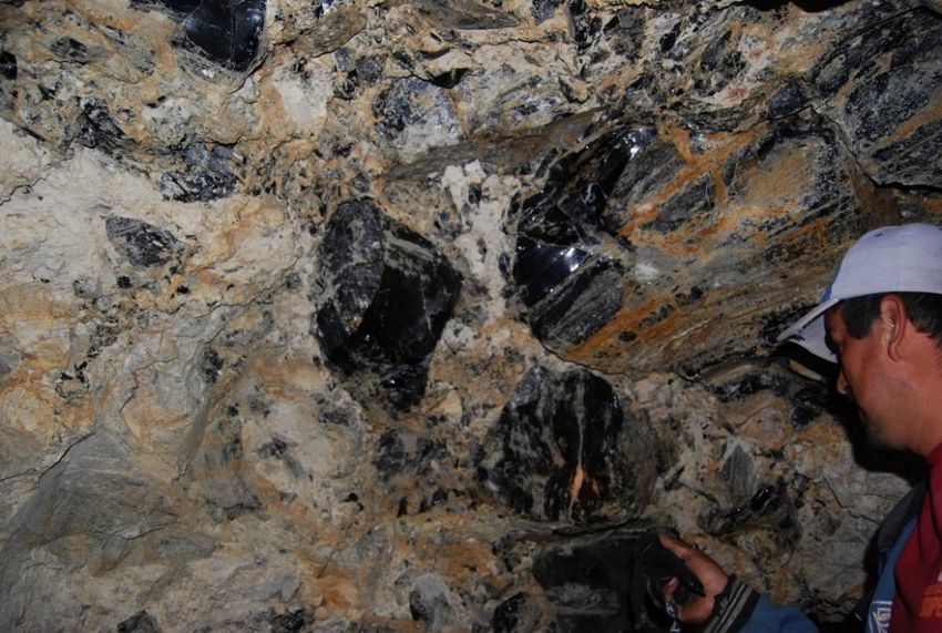

Lithic Raw Materials Procurement Networks in Corsica
in the 2 and 1 Millennia: The I Casteddi Case
nd st
Arthur Leck1, Cheyenne Bernier1, Bernard Gratuze2, Hélène Paolini-Saez3, François-Xavier Le Bourdonnec1
1
Université Bordeaux Montaigne, IRAMAT-CRP2A, UMR 5060 CNRS, Pessac, France
2
Université d'Orléans, IRAMAT-CEB, UMR 5060 CNRS, Orléans, France
3
Laboratoire Régional d’Archéologie, Ajaccio, France & Adjunct Research Fellow, Université de Toulouse Jean-Jaurès, TRACES, UMR 5608 CNRS, Toulouse, France
The I Casteddi site (423 m a.s.l.) is located on the municipality of Tavera, in the Gravona valley, in West-central Corsi-
ca. The landscape is one of middle and high mountain, in one of the main transverse valleys linking the Haute-Corse
and Corse-du-Sud. I Casteddi is composed of a standing stone (statue-menhir) erected on the Tagliafarro pass and,
300 meters north, a settlement placed on a headland organised in successive terrasses. The excavations led since
2014 have highlighted an oval-shaped dwelling, dated from the Middle Bronze Age and including hearth floors, nu-
International Obsidian Conference — 2021
merous food macroremains, and domestic objects (Paolini-Saez and Arobba, 2018; Paolini-Saez et al., 2021).
A provenance study on 182 obsidian and 249 rhyolite artefacts was conducted at the IRAMAT
following a strictly non-destructive protocol. Among the artefacts analysed, 45% originate from
the Middle Bronze Age occupation levels, 15% from the Final Bronze Age, and 35% from the Late
Iron Age. These proportions indicate a continuity in the lithic raw material procurement and ex-
ploitation on the site. During the Middle Bronze Age, in particular, the artefacts originating from
the dwelling refer to domestic contexts linked to food preparation. During the Late Iron Age, they
are associated with a floor exhibiting signs of artisanal activities, in the margins of a silo, including
metalwork and domestic activities that are yet to be identified.
DRAC-Corse © corseaérovision ©
Obsidian — EDXRF data
Geochemical analyses were conducted on the obsidian ar-
tefacts using EDXRF and LA-ICP-MS (Gratuze, 1999; Orange
et al., 2017). By comparing the compositional data obtained
on the artefacts to those of geological samples from the is-
land-sources of the Mediterranean, we can affirm that the
majority of the obsidian found at I Casteddi originates from
Sardinia. The SC type greatly predominates (SA: 38, SB1: 1,
SB2: 8, SC: 133). Two artefacts remain of unknown origin.
These results could attest of a continuity of exchanges within
the corso-sardinian bloc.
The geochemical compositions of the rhyolite artefacts were
determined by EDXRF (Leck et al., 2018) and compared to a
geological database constituted of several dozen outcrops
sampled in Corsica as well as artefacts already analysed on
other sites. The results show that the rhyolites come from a
minimum of 25 distinct sources, clustered into 13 visually co- Obsidian — LA-ICP-MS data
herent groups (according to texture, inclusions, colours, and
cortex). Although they cannot all be precisely located for the
moment, the high diversity of sources exploited reveals the
high mobility of this community. The mountains located in the
centre of the island, which have a high potential for herding
and hunting, seem to be a privileged area of procurement;
this is especially the case for the Alzu plateau, which rhyolites
were intensely exploited from the final Neolithic onwards.
Rhyolite — EDXRF data
The dichotomy between the lithic procurement patterns – exogenous and therefore maritime for obsidian and
allochthonous and mountainous for the rhyolite – is interesting. Do we have two separate and contemporary
networks, one linked to long-distance exchanges and the other to the mobility of the group within its territory?
Or are those differences chronologically distinct and attest to the changes in the networks of the late Neolithic Some examples of rhyolites found at I Casteddi correspond-
and Bronze Age? Further studies will have to be conducted to better define the evolution exchange and mo- ing to groups M (a., b. and d.), K(c.), C(e.), E(f.) and L(g.)
bility on the island during the Bronze Age.
References
Gratuze, B., 1999. Obsidian Characterization by Laser Ablation ICP-MS and its Application to Prehistoric Trade in the Mediterranean and the Near East: Sources and Distribution of Obsidian within the Aegean and Anatolia, J. Archaeol. Sci. 26, 869–881.
Leck, A., Le Bourdonnec, F.-X., Gratuze, B., Dubernet, S., Ameziane-Federzoni, N., Bressy-Leandri, C., Chapoulie, R., Mazet, S., Bontempi, J.-M., Marini, N., Remicourt, M., Perrin, T., 2018. Provenance d’artefacts en rhyolite corse : évaluation des méthodes d’analyse géochimique, C. R. Palevol 17, 220–232.
Orange, M., Le Bourdonnec, F.-X., Bellot-Gurlet, L., Lugliè, C., Dubernet, S., Bressy-Leandri, C., Scheffers, A., Joannes-Boyau, R., 2017. On sourcing obsidian assemblages from the Mediterranean area: analytical strategies for their exhaustive geochemical characterisation, J. Archaeol. Sci. Rep. 12, 834–844.
Paolini-Saez, H., Arobba, D., 2018. Etude carpologique du site fortifié d’I Casteddi (Tavera, Corse-du-Sud), In Marticorena, P., Ard, V., Hasler, A., Cauliez, J., Gilabert, C., Sénépart, I. (Eds), “Entre deux mers” and Actualité de la Recherche, Proceedings of the XIIe Rencontres Méridionales de Préhistoire Récente,
Bayonne, 29 September – 1 October 2016, Toulouse: Archives d’écologie préhistorique, p. 341–348.
Paolini-Saez, H., Villat, X., Jamai-Chipon, A., 2021. L’occupation protohistorique d’I Casteddi de Tavera (Corse-du-Sud), In Six millénaires en Balagne — Sei millenii in Balagne, Balagna, Ghjussani, Ostriconi, Falasorma : archéologie, histoire, architecture et toponymie, Proceedings of the IIIe colloque du
Laboratoire régional d’archéologie, Belgodere, 14–16 October 2016, Cahier Corsica 281-301, p.249–264.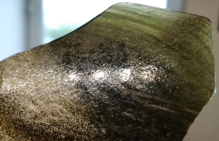
Obsidian Maritime Interconnections in Early Holocene
Eastern Mediterranean
Theodora Moutsiou1, Phaedon Kyriakidis2, Andreas Nikolaidis2, Georgios Leventis2, Alexandros Constantinides2,
2 2 1 1 1
Evangelos Akylas , Constantine Michailides , Carole McCartney , Stella Demesticha , Vasiliki Kassianidou ,
Zomenia Zomeni3, Daniella Bar-Yosef Mayer4
(1) Archaeological Research Unit, University of Cyprus
(2) Department of Civil Engineering and Geomatics, Cyprus University of Technology
(3) Geological Survey Department, Ministry of Agriculture, Rural Development and the Environment of the Republic of Cyprus
(4) The Steinhardt Museum of Natural History, Tel Aviv University
Introduction
Although archaeological evidence has provided a relatively clear picture of when the island of Cyprus was inhabited, there is still considerable debate as to where these inhabitants originated from, as well as the routes they most likely followed to reach the
island. Based purely on similarities of the material record, e.g. architecture, lithic technology, fauna, between Cyprus and its surrounding mainland (e.g. Vigne et al. 2011), research has suggested Anatolia and/or the Near East as the original homelands of the
first Cypriot settlers (Peltenburg et al. 2001). Obsidian is a common feature of the material culture of the broader region, with material from Anatolian sources traversing the Near East (Figure 1) as far south as Israel (Ibáñez et al. 2015). Obsidian artefacts are
also found on the neighbouring island of Cyprus. No geological sources of obsidian occur on the island (Figure 2), which has never been connected to the continent with any form of land bridge. This indicates that obsidian could have only reached Cyprus via
seafaring (Moutsiou 2018). Determining the most likely routes for these mainland-island maritime crossings can provide significant information about the Eastern Mediterranean ‘socialscape’ at the transition from the Pleistocene to the Holocene.
Figure 1. Obsidian distribution in the Near East during
The consumption of obsidian on the island of Cyprus the Pre-Pottery Neolithic B (PPNB), 8,500-6,400 cal
BC (from Ortega et al. 2016).
The island of Cyprus in the Eastern Mediterranean is rich in good quality raw material resources for human exploitation, such
as chert, but obsidian is not one of them. Nevertheless exotic obsidian appears in lithic assemblages of Early Holocene (8900- Figure 2. Map showing the location of the main
6400 cal BC) sites across the island (Figure 3).Obsidian artefacts are mostly in small quantities (20-50 pieces), although larger geological sources of obsidian in the eastern
Mediterranean region neighbouring the island of
assemblages are also known, such as Parekklisia Shillourokambos (~600) and Akanthou Arkosyko (~5000). Unretouched
Cyprus. [Note: 1=Melos, 2=Antiparos, 3=Giali,
blades and bladelets dominate the assemblages, formal tools are extremely rare and no evidence for in situ tool manufacture 4=Sakaeli, 5=Acigöl, 6=Nenezi Dag, 7= Göllüdağ,
has been unearthed anywhere on the island (Moutsiou 2018). Complete obsidian assemblages were elementally characterised 8=Erzincan, 9=Ikizdere, 10=Kars, 11=Sarikamis,
using X-ray Fluorescence Spectrometry (XRF) and demonstrated the dominance of central Anatolian obsidian sources in the 12=Erzurum, 13=Bingöl, 14=Mus, 15=Meydan Dag,
16=Suphan Dag, 17=Nemrut Dag, 18=Arteni,
Cypriot archaeological assemblages (Figure 4).
19=Ashotsk, 20=Chikiani]. From Moutsiou 2019.
Figure 4. Discriminant Function Analysis
(DFA) comparing pXRF data on obsidian
from Aceramic Neolithic Cyprus with the
main Eastern Mediterranean geological
obsidian sources. The figure shows that
based on Sr/Rb and Zr/Rb ratios and Ti
absolute values, the majority of the Cypriot
obsidian can be attributed to the central
Anatolian source of Göllü dağ. Colours:
black=Shillourokambos, green=Ais Giorkis,
orange=Mylouthkia, pink=Arkosyko
(covered by the Shillourokambos main
cluster), purle=Tenta (Moutsiou 2018).
Modeling maritime connectivity in the Eastern Mediterranean
To support archaeological inquiry and inference regarding prehistoric seagoing to/from Cyprus, this project employed
Fig. 1. The location of Thorikos
Figure 3. Map showing the main Aceramic Neolithic (8900- Lagrangian-based simulation algorithms for modelling the drift-induced, as well as directed sea-borne movements,
6400 cal BC) sites on Cyprus with documented presence of based on data and assumptions regarding the prevailing paleo-environmental conditions and vessel characteristics.
obsidian. Although directed seaborne movements are still under investigation, preliminary drift-induced simulation results
indicate that there exist at least two periods, during winter for South to North routes (south coast of Anatolia - Cyprus
In Aceramic Neolithic Cyprus, obsidian—when not a surface find—usually derives from contexts that represent everyday and vice versa), and during summer, for East to West routes (eastern coast of Levant – Cyprus and vice versa),
activities. Most of the obsidian pieces found across Cyprus (Figure 5) are associated with living floors or fills interior or exterior whereby the sea state is favourable to drifting vessels, especially for shorter distances. During almost all the time,
to building structures. In fact, in all documented instances, there are only two occasions where obsidian artefacts are found departures from the southern side of the Levantine mainland are blocked by currents flowing almost parallel to the
within ‘special’ contexts, although the notion of their association with activities such as feasting or grave goods remains weak. coast (Nikolaidis et al. 2020, Figure 7).
Although the stratigraphic association of obsidian artefacts with domestic rather than religious or other ritual contexts is usually
taken to mean that obsidian had no significant value in Aceramic Neolithic Cyprus, it is argued that objects can accrue special
value beyond their original functionality, especially when made of materials that are rare, visually distinctive and found at great
distances from their source (Saunders 2001, Moutsiou 2018).
Figure 5. Obsidian artefacts from Early Holocene (Aceramic Neolithic) Cyprus.
Obsidian distribution on Cyprus
Least Cost Pathways (LCP) analysis of obsidian distribution across the island (Moutsiou and Agapiou 2019) demonstrates that
water played an important role in facilitating obsidian movement on Early Holocene Cyprus. Specifically, our models suggest
that (a) riverine and (b) coastal waterways were commonly exploited by the early inhabitants of the island in the context of
social exchanges (Figure 6). Moreover, the analysis suggests that not all insular communities were involved in the social Figure 7. Simulations of prehistoric seagoing to/from Cyprus based on drift-induced modelling (Nikolaidis et al. 2020).
landscape delineated by obsidian circulation. The LCP model clearly shows a fragmentation between north and south. A
possible explanation could be that in the division between coastal obsidian-bearing sites and inland sites with no obsidian we
are, in fact, observing two distinct (contemporaneous but separated) social territories. In this context, the north and south
Maritime obsidian networks in the Eastern Mediterranean
coastlines experience an influx of new populations from the mainland, who settle themselves along the coast as a first stage in The location of Early Holocene obsidian-bearing sites along the north and south coasts of the island and the
the colonization process. During this initial exploration phase, humans are more likely to be risk-averse and obsidian objects apparent obsidian gap between the two regions likely support two different mainland routes for the introduction of
would enable the maintenance of social ties as an adaptive strategy in the new conditions. obsidian to Cyprus: (a) Levant and south coast of Cyprus, and (b) Turkey (Anatolia) and north coast of Cyprus. The
application of simulation-based modelling of sea-borne movement in the Eastern Mediterranean allows us to test
Figure 6. Least Cost Paths Analysis (LCPA) of
Aceramic Neolithic sites on Cyprus. The analysis
these hypotheses and determine the most realistic routes for obsidian maritime movement between the island of
has shown that not all contemporary sites use Cyprus and its surrounding mainland. Work so far points supports both scenarios as likely. The lack of obsidian-
obsidian. On most occasions sites that do not use bearing sites on the southern coast of Turkey contemporaneous with those found on Cyprus may point towards a
obsidian are located at a distance from the least closer link with the Levantine mainland.
cost routes. However, on some occasions, such as
Agrokipia Paleokamina and Pera Chorio Moutti,
obsidian is absent from the lithic assemblages even Conclusions
though the sites fall on the least cost route. The
image also illustrates that obsidian circulation is
fragmented with exploitation restricted along the Complex networks of exchange, where some long distance
north and south coasts and a major gap in the links between non-neighbouring villages were present (Ortega
interior of the island. Sites: 1=Akamas Aspros, et al. 2016) in the mainland from the PPNA, with settlements
2=Akrotiri Aetokremmos, 3=Nissi Beach, 4=Vretsia
Roudias, 5= Agrokipia Paleokamina, 6=AVA
able to develop and maintain distant exchange links that
Asprokremmos, 7=Politiko Kelaidoni, 8=Pera Chorio connected different regional exchange networks. The
Moutti, 9=Alambra Spileos and Koudourka, 10=Ayia subsequent PPNB period sees an increase in obsidian
Anna Perivolia, 11=Mari, 12=Kissonerga consumption and longer-distance networks. The detailed
Mylouthkia, 13=Choletria Ortos, 14=Krittou
Marottou Ais Giorkis, 15=Limnitis Petra tou Limniti,
analysis of obsidian on Cyprus demonstrates similar patterns
16=Parekklisia Shillourokambos, 17=Ayios were taking place on Cyprus too. The island across the sea
Tychonas Klimonas, 18=Kalavasos Tenta, was an active participant in this broader ‘socialscape’ that
19=Khirokitia Vouni, 20=Akanthou Arkosyko, joined mainland and insular prehistoric communities together.
21=Cape Andreas Kastros. [Note: sites 2 and
4=Epipalaeolithic, 1 and 3=Epipalaeolithic?, 5-
Obsidian exchange (Figure 8), in particular, facilitated the
11=Aceramic Neolithic with no obsidian, 12- creation and maintenance of long-distance maritime networks. Figure 8. Obsidian artefacts from Early Holocene/Aceramic Neolithic
20=Aceramic Neolithic with obsidian]. (Moutsiou Social networks are a valuable asset crucial for the sharing of Cyprus.
and Agapiou 2019). information, resources and genes.
References This work was conducted as part of Contact:
Ibañez, J.J., Ortega, D., Campos, D., Khalidi, L., Méndez, V. 2015. Testing complex networks of interaction at the onset of the Near Eastern Neolithic using modelling of obsidian exchange. Journal of the Royal Society Interface 12: 20150210 project SaRoCy, a two- year research
Moutsiou, T. 2019. A compositional study (pXRF) of Early Holocene obsidian assemblages from Cyprus, Eastern Mediterranean. Open Archaeology 5(1): 155-166 project implemented under the tmouts01@ucy.ac.cy
Moutsiou, T. 2018. The obsidian evidence for trans-maritime interactions in the Eastern Mediterranean: The view from Aceramic Neolithic Cyprus. Journal of Mediterranean Archaeology 31(2): 232-251 “Excellence Hubs” Programme (contract UNIVERSITY OF
Moutsiou, T., Agapiou, A. 2019. Least cost pathway analysis of obsidian circulation in Early Holocene–Early Middle Holocene Cyprus. Journal of Archaeological Science: Reports, 26. 101881. number EXCELLENCE/0198/0143) of the
Nikolaidis, A., Akylas, E., Michailides, C., Moutsiou, T., Leventis, G., Constantinides, A., McCartney, C. et al. 2020. Modeling drift-induced maritime connectivity between Cyprus and its surrounding coastal areas during early Holocene. EGU General Assembly RESTART 2016-2020 Programmes for
CYPRUS
Fig. 6. Concentration maps showing the content of copper (Cu), lead (Pb), silver (Ag), iron (Fe),
Conference Abstracts, p. 19782. Research, Technological Development P.O. Box 20537. CY-
Ortega D., Ibáñez J.J., Campos D., Khalidi L., Méndez V.,Teira L. 2016. Systems aluminium (Al) and
of Interaction between arsenic
the First Sedentary (As)
Villages in the Near East Exposed Using Agent-Based Modelling of Obsidian Exchange. Systems 4,18. and Innovation administered by the 1678 Nicosia, CYPRUS
Peltenburg, E.J., Colledge, S., Croft, P., Jackson, A., McCartney, C., Murray, M.A. 2001. Neolithic dispersals from the Levantine corridor: a Mediterranean perspective. Levant 33: 35-64. Research and Innovation Foundation of
Saunders, N.J. 2001. A dark light: reflections on obsidian in Mesoamerica. World Archaeology 33: 220-36. Cyprus. The project’s website is Tel. +357 2289357
Vigne, J.-D., Carrère, I. Briois, F., Guilaine, J. 2011. The early process of mammal domestication in the Near East. Current Anthropology 52(4): S255-S271. https://sarocy.cut.ac.cy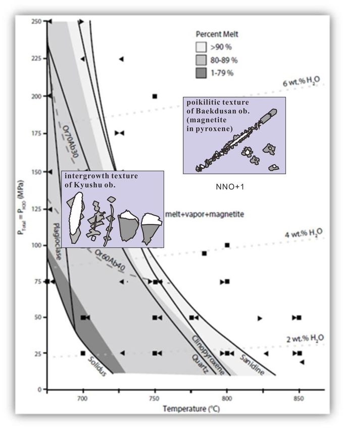
Annadel and Glass Mountain Obsidian Sources in Sonoma County, California
Robert H. Tykot1 & Michelle Hughes Markovics2
1Department of Anthropology, University of South Florida, Tampa, USA. Email: rtykot@usf.edu; 2Santa Rosa College, Sonoma, CA.
International Obsidian Conference, April 30 - May 2, 2021
Introduction Methods – pXRF Analysis
Elemental analysis of a collection of prehistoric obsidian artifacts Many analytical methods have been used to successfully
in the Pepperwood Preserve Museum were conducted, followed by distinguish between obsidian sources in the Americas. In this
a non-systematic survey of two major obsidian sources in the study, obsidian artifacts were analyzed using a Bruker III-V+
southern North Coast Ranges of California. Specifically, 28 artifacts non-destructive, portable X-ray fluorescence spectrometer.
in the Pepperwood assemblage, from late prehistoric Native This analytical method has been shown to be very successful
American sites in the region, were analyzed non-destructively using on obsidian sourcing (Tykot 2016, 2018, 2021). A specific
a Bruker Tracer III-V+ portable X-ray fluorescence spectrometer, “obsidian” filter (76 μm Cu, 25 μm Ti, 305 μm Al) was used
with a filter and time settings emphasizing results for the K-lines to enhance results for certain trace elements (Rb, Sr, Y, Zr,
energy range of elements Fe through Nb. At least 25 geological Nb) known to be useful for sourcing, while the analysis
samples each from Annadel (in the Sonoma Valley) and from Glass settings chosen were 40 kV, 10 μA, and 180 seconds. The
Mountain (Napa Valley) also were analyzed. results were calibrated using a 2008 Excel program with
obsidian standards from the University of Missouri
Artifacts Columbia, analyzed by INAA, LA-ICP-MS, and XRF.
Located in the heart of traditional Wappo Indian territory,
Pepperwood has an extensive prehistory and history of Native use Results
(Eisemann & Fredrickson 1980). Ethnographic accounts indicate Map showing obsidian sources in An X-Y graph of Rb/Nb vs. Sr/Nb provides a clear
that the Wappo often traveled outside their territory to supplement northern California. The green
distinction between the Annadel State Park and Glass
star is the Pepperwood Preserve.
local resources; e.g. traveling to Lake County to fish (and likely to Mountain geological obsidian samples. Sixty percent of the
exploit nearby obsidian sources), to Bodega Bay to exploit marine artifacts from Pepperwood were assigned to Glass Mountain,
resources/trade with Pomo and Miwok groups, and to nearby Napa and twenty-one percent to Annadel. Five other artifacts did
Valley to obtain obsidian from Glass Mountain (Sawyer 1978; not match with either and represent at least three other
Eisemann & Fredrickson 1980). The 28 artifacts analyzed were geological sources. A total of twelve sources have been
selected from surface collections in the Pepperwood Preserve, and identified in this region, with notable differences in their
include formal tools, flakes, cores, and tool fragments. quality, physical appearance, and selection for producing
stone tools (Jackson 1989).
Summary for Geological Samples
Anadel
no. = 29 Fe Rb Sr Y Zr Nb Ba Th
Analyses conducted with a Bruker III-V+ ave 12262 106 44 39 229 12 490 9
std 342 4 2 2 6 1 29 1
min 11770 100 38 36 218 10 438 7
max 13087 113 49 43 241 15 553 11
Glass Mountain
Analytical Data for Obsidian Artifacts Tested no. = 25 Fe Rb Sr Y Zr Nb Ba Th
ave 7150 143 12 35 194 12 289 13
Sample USF # Fe Rb Sr Y Zr Nb Ba Th Source std 393 7 1 2 11 1 57 1
PW1 14325 10837 140 44 38 219 12 364 12 Annadel min 6191 127 11 31 175 11 202 10
PW2 14326 7590 144 20 28 180 11 331 14 Glass Mountain max 8066 155 13 40 223 14 425 15
PW3 14327 21982 78 101 33 303 17 829 18 ?
PW4 14328 7198 135 9 37 195 13 354 12 Glass Mountain
PW5 14329 8240 155 21 32 195 12 262 17 Glass Mountain
Obsidian artifacts in the Pepperwood Preserve PW5b 14329 8037 135 17 38 210 12 192 13 Glass Mountain
PW6 14330 7381 136 10 37 190 10 300 13 Glass Mountain
PW7 14331 7515 146 12 42 214 12 86 13 Glass Mountain
Potential Sources PW8
PW9
14332 7034 148 12 35 198 12 224 13
14333 7557 154 12 38 185 12 116 8
Glass Mountain
Glass Mountain
There are at least eight known obsidian sources within 100 miles PW10
PW11
14334 11837 134 33 36 205 8 378 11
14335 7822 142 10 43 211 13 202 13
?
Glass Mountain
of the Pepperwood Preserve that could potentially be the source of PW12 14336 7499 152 15 39 206 14 238 9 Glass Mountain
PW13 14337 10541 130 42 38 227 14 486 14 Annadel
the artifacts tested. These include sources at Borax Lake and Mt. PW14 14338 10309 119 45 37 196 14 307 11 Annadel
PW15 14339 7145 145 17 32 188 12 323 7 Glass Mountain
Konocti in Lake County, Mt. Burdell in Marin County, Glass PW16 14340 7657 148 12 33 182 10 340 13 Glass Mountain
PW17 14341 9093 120 14 35 227 30 637 15 ?
Mountain in Napa Valley, and the Annadel, Franz Valley, Oakmont PW18 14342 6967 131 11 34 178 11 335 15 Glass Mountain
(Los Guilicos A & B) and Trinity sources in Sonoma County PW19
PW20
14343 11115 138 36 29 207 9 349 11
14344 12033 138 44 28 223 14 517 14
?
Annadel
(Silliman 2005). Two major sources were visited, with 29 geological PW21
PW22
14345 11759 130 46 39 228 13 244 16
14346 6777 151 13 37 193 12 300 16
Annadel
Glass Mountain
samples collected from nearby Annadel State Park and 25 from PW23
PW24
14347 13021 102 48 42 249 15 605 5
14348 8023 139 19 28 200 11 246 13
Annadel
Glass Mountain
Glass Mountain. PW25 14349 8228 139 15 39 192 14 347 9 Glass Mountain
PW26 14350 7775 151 20 29 210 13 209 11 Glass Mountain
PW27 14351 11076 133 47 21 204 9 534 14 ?
X-Y Graph showing Annadel and Glass Mountain
geological samples, and Pepperwood Preserve artifacts
Comparison of the calibrated pXRF data and trace element ratios with analytical data from other
studies will be used to suggest what other sources are represented by these outliers; comparison of
data from different analytical methods and calibration software is not straightforward.
Conclusions
Our results discriminate among the different sources in northern California, and allow us to
attribute archaeological artifacts to them, and address issues about obsidian procurement, trade and
Glass Mountain
Annadel Park usage in this region. This pilot study complements the small number of other studies done and with
further work we hope to enhance current understanding of Native American lifeways in this region.
The overall results will be compared with other research on trade and exchange of obsidian in
this region of California.
References
California Obsidian Source Index. Northwest Research Obsidian Studies Source Catalog. http://sourcecatalog.com/ca/s_ca.html.
Eisemann, Lynn, and David Fredrickson (1980) Archaeological Investigations at CA-SON-1208 Located in the Franz Valley Area of Sonoma County, California. Cultural
Resources Facility at Sonoma State University.
Geological samples from Annadel Park (left) and Glass Mountain (right) Jackson, T. L. (1989). Late prehistoric obsidian production and exchange in the North Coast Ranges, California. Contributions of the Archaeological Research Facility 48: 79-
94.
Obsidian Source Maps: United States. Northwest Research Obsidian Studies Laboratory. http://www.obsidianlab.com/image_maps/image_maps.html#ca.
Sawyer, Jesse O. (1978) Wappo. In Handbook of North American Indians: California 8:256–263.
Silliman, Stephen W. (2005) Obsidian Studies and the Archaeology of 19th-Century California. Journal of Field Archaeology 30(1):75–94.
Tykot, R.H. 2016. Using Non-Destructive Portable X-Ray Fluorescence Spectrometers on Stone, Ceramics, Metals, and Other Materials in Museums: Advantages and
Limitations. Applied Spectroscopy 70(1): 42-56.
Tykot, R.H. Portable X-Ray Fluorescence Spectrometry (pXRF). 2018. In S.L. López Varela (ed.), The SAS Encyclopedia of Archaeological Sciences, pp. 1-5. John Wiley &
Sons, Inc.
Tykot, R.H. 2021. Obsidian in Prehistory. In P. Richet (ed.), Encyclopedia of Glass Science, Technology, History, and Culture. John Wiley & Sons, Inc.
Acknowledgments
Thanks to Benjamin Benson from the Pepperwood Preserve for providing access to their collections.
OBSIDIAN AND SALT IN THE KHOY PLAIN
UNCOVERING THE EARLY BRONZE AGE OBSIDIAN PROCUREMENT SYSTEM OF
THE SALT MINE OF TAPPEH DOOZDAGHI, NORTHWESTERN IRAN
Marie Orange1,2,3,4, Akbar Abedi5, François-Xavier Le Bourdonnec2, Afrasiab Garavand6, Fatemeh Malekpour7, Catherine Marro3
1
Archaeology and Palaeoanthropology, School of Humanities, Arts and Social Sciences, University of New England, Australia; 2IRAMAT-CRP2A CNRS UMR 5060, Université Bordeaux Montaigne, France; 3Archéorient—Environnements et Sociétés de l’Orient Ancien CNRS UMR
5133, Maison de l’Orient et de la Méditerranée, France; 4Southern Cross GeoScience, Southern Cross University, Australia; 5Department of Archaeology and Archaeometry, Tabriz Islamic Art University, Iran; 6Mohaghegh Aradabili University, Iran; 7West Azerbaijan Cultural Heritage, Tourism and Handicraft Organisation, Iran
TAPPEH DOOZDAGHI MATERIALS & METHODS OBSIDIAN PROCUREMENT DISCUSSION
Materials Gutansar • The 40 obsidian artefacts from the Early
Arteni Bronze Age levels of Tappeh Doozdaghi come
• 40 obsidian artefacts were retrieved from Syunik
Geghasar from seven different sources located in both
the Early Bronze Age occupation level; they Nemrut Dağ
3 Eastern Anatolia and the Southern Caucasus.
were all analysed by portable XRF. 5 Unknown
• High obsidian procurement diversity suggests
that the Khoy plain attracted populations from
Methods 7
SOURCES varied horizons during the Early Bronze Age. They
• Instrument: Bruker Tracer III-SD were likely drawn by the numerous natural
resources available in the Khoy plain, such as
• Calibration: MURR obsidian calibration
28 arable land, winter pasturelands, abundant water
• Elements measured: Mn, Fe, Zn, Ga, Th, Rb, sources, and salt.
Sr, Y, Zr, Nb
Gügürbaba-Meydan • Similar obsidian sources diversity is also
• Measurement specifications: 180 seconds, observed on the salt mine of Duzdagi, in
40 Kv, 39 µA, green filter (0.006” Cu, 0.001” Ti, Nakhhivan (>90 km North), where both ceramic
• High diversity of obsidian sources exploited
• Salt mine located in the Khoy plain, 0.012 Al) and obsidian assemblages hint at a possible role of
(7 in total) from Eastern Anatolia (72.5%) and
Northwestern Iran • Standards: Several standards were analysed the Southern Caucasus (25%). ‘pastoralist hub’ during the Kura-Araxes period.
• 16 hectares, culminates at c. 24 meters at the beginning and end of each run to ensure • Highlights the key role of local resources (e.g.
above the surrounding landscape the repeatability, accuracy, and precision of Caucasus salt) in the larger circulation system of other
our measurements. (25 %)
staples (e.g. obsidian) and in creating economic
• First excavation campaign in 2016
and social hubs for populations at the regional
• Late Neolithic to Iron Age occupation and interegional level.
• High concentration of Early Bronze Age
24 meters above surrounding Eastern Anatolia
material culture remains (c. 3500-2400 BCE) landscape (72.5 %)
Early Bronze Age ceramics
from Tappeh Doozdaghi
©A. Abedi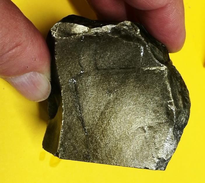
Provenance Study of Silicic Stone Tools from Hajdúság (E Hungary)
              by Using PIXE and PIGE Techniques.
               Péter Rózsa1, Árpád Csámer1, Sándor Tóth1, Zita Szikszai2, Zsófia Kertész2,
                              Ákos Csepregi2, Sándor Gönczy3, Béla Rácz3
  1Department of  Mineralogy and Geology, University of Debrecen, Debrecen, Hungary
  2Institute
           for Nuclear Research (ATOMKI), Laboratory for Heritage Science, Debrecen, Hungary
  3Ferenc Rákóczi II Transcarpathian Hungarian Collage of Higher Education, Beregovo, Ukraine

                       The loessy area of the Hajdúság and Hajdúhát micro-regions (Hajdú-Bihar County, East
                       Hungary) have been inhabited from the Paleolithic. During pilot field-surveys
                       seventeen pieces of chipped silicic stone tools were collected from 21 non-excavated
                       registered archaeological sites located in the southern part of these micro-regions (Fig.
                       1). The collection area of approximately 560 square km is dominantly agricultural field,
                       and the findings could be collected directly from the surface of the arable land. Seven
                       obsidian findings and ten tools made of other (hydrothermal or limnic) silicic raw
                       material were analyzed. Major and trace element composition of the stone tools were
                       analyzed by Particle Induced X-ray Emission (PIXE) and Proton Induced Gamma-ray
                       Emission (PIGE) techniques. The detected element spectrum includes alkali metals (Li,
                       Na, K, Rb), alkali earth metals (Mg, Ca, Sr, Ba), metals (Al, Ti, V, Cr, Mn, Fe, Co, Ni, Cu,
                       Zn, Ga, Y, Zr, Nb, Hf, Pb), metalloids (B, Si, Ge, As), non-metals (P, S, Se), halogens (F, Cl,
                       Br), as well as lanthanides and actinides (Ce, Th, U), too, although detected
                       concentrations less than 100 ppm have low accuracy. Silica concentrations of the
                       obsidian samples range between 72 and 78%, and, in general, they can be
                       characterized by relatively high Sr, Ba, and Cl content.

                       Fig. 1. Location of findings (cross: site of sample; cross in square: site of analyzed sample)

                                                       For Transylvanian obsidian tools Ti/Mn vs Rb/Zr binary
                                                       diagram was used as provenance fingerprint
        C2E                                            (Constantinescu et al. 2002). As the Transylvanian
                                                       findings, most of our samples belong to the field of C1
                                                       (Slovakian) type; there is only one sample which can be
                                                       C2T type, i.e. may originate from the Hungarian part of
                                  C1                   the Tokaj Mountains (Fig. 2).
       C2T                                             The hydrothermal and limnic silicic material has more than
                                                       98% SiO2 content. Beside silica, quantity of Al2O3 (less
                                                       than 1%) as well as Na, Mg P, K, Ca (some hundreds ppm)
                                                       can be detected. In some samples some hundreds ppm of
                                                       chlorine was analyzed. Presumably, sources of raw
        Fig. 2. Ti/Mn vs Rb/Zr diagram
                                                       material of these tools could be traced in the Tokaj
                                                       Mountains.
Reference
Constantinescu, B., Bugoi, R., Sziki, G. 2002: Obsidian provenance studies of Transylvania's Neolithic tools
using PIXE, micro-PIXE and XRF. Nucl. Inst. Meth. 189. 1-4. 373-377.
Acknowledgement
Financial support by the Access to Research Infrastructures activity in the Horizon 2020 Programme of the EU
(IPERION CH Grant Agreement n. 654028) is gratefully acknowledged.
Poster 8
Measurement of Magnetic Susceptibility of Obsidian from
Research paper information!!
Shirataki, Hokkaido, Japan, to Identify the Source of Obsidian Tools This study is now published in Journal of Regional Resource Management,1,35-43
https://u-hyogo.repo.nii.ac.jp/?action=pages_view_main&active_action=repository_view_m
○Kyohei SANO (Graduate School of Regional Resource Management, University of Hyogo) ain_item_detail&item_id=6238&item_no=1&page_id=13&block_id=46
Introduction Analytical method
Magnetic susceptibility is often used to identify the source of tools and tombstones that are made
from igneous rocks, such as obsidian and granite. This study reports on how the relationship between I constructed an obsidian wafer for the measurement of magnetic susceptibility. First, I cut the
magnetic susceptibility and sample thickness of obsidian contributes to identifying the source of samples with a rock cutter to create wafers of different thicknesses, ranging from 2.05 to 23.28 mm . The
obsidian tools. Obsidian samples from Shirataki, Hokkaido, Japan, were analyzed, focusing on those length, width, and area of the wafers range from 28.4 to 38.3 mm, from 22.2 to 34.0 mm, and from 724.2
from the lava flows of Tokachi-Ishizawa (TI), Akaishiyama (AK), and Horoka-Yubetsu (HY). to 1302.2 mm2respectively.
Results revealed that obsidian from the HY lava Thereafter, I measured the magnetic susceptibility by using the KT-10v2 magnetic susceptibility meter
demonstrated the highest value of magnetic (Terraplus Inc.), which has a sensitivity of 1 × 10⁻⁶ SI and range from 0.001 × 10⁻³ SI to 1999.99 ×10–3 SI,
susceptibility among the analyzed samples; thus, along with the sample thickness by using a digimatic micrometer (Mitutoyo Corp.). The analytical error
obsidian from the HY lava could be identified by this for the digimatic micrometer was 2 μm. I conducted 15 analyses on the center of each wafer for the
characteristic. Concurrently, heterogeneity in the measurement of magnetic susceptibility.
magnetic susceptibility within a single lava flow was
observed in the AK lava. These results could
contribute to the identification of the source of
obsidian tools and development of non-destructive
techniques for measurement of magnetic Results and Discussion Relation between magnetic susceptibility and rock texture
susceptibility. AK lava from the Hachigosawa and Kyukanosawa outcrops
Results for HY lava show the peak of magnetic susceptibility. exhibited different trends for magnetic susceptibility.
This peak could be because the sample thickness is beyond the
range of the analytical depth for magnetic susceptibility. This
The microlite number density (Nv number/m 3 ), in
Geological Setting and Samples implies that the samples have boundary thickness to make
the magnetic susceptibility constant. particular, was calculated from the number of crystals
This study calls that boundary thickness as the effective and the measured volume. The Nv values for Shirataki
140°E 145°Ε
Akaishiyama Akaishiyama (AK) lava
a thickness. The results indicate that the effective thickness for the obsidian were 5.0 × 10 13–7.9 × 10¹³ /m3 for the TI lava,
45°N Shirataki Hachigosawa outcrop
Horoka-Yubetsu (HY) lava HY lava is between 5 and 11 mm. 1.0 × 10 1 4 –1.0 × 10 1 5 /m 3 for the AK lava from the
Hokkaido
Ajisainotaki outcrop
Hachigosawa outcrop, 1.1 × 10¹⁴–1.8 × 10¹⁴ /m3 for the
40°Ν
Akaishiyama lower lava
Kyukanosawa outcrop AK lava from the Kyukanosawa outcrop, and 4.5 × 10¹³ –
Pacific Ocean
Shikatoride Upper lava
Horoka-Yubetsu
caldera rim 1.2×10 14 /m 3 for the HY lava (Wada and Sano, 2011;
850m lava dome
Tokachi-Ishizawa (TI) lava Sano et al., 2015) and it is difficult to explain the
35°Ν 300 km Shikatoride
difference in magnetic susceptibility based only on the
Tokachi-Ishizawa
difference in the number density. Oxide microlite in
Shikatoride Lower
lava 830m lava dome
outcrop
N
obsidian can vary in morphology, including acicular,
euhedral and bead-like magnetite.
Kita-Yunosawa lava
TI lava Although further investigation is
1 km
necessary to reveal the relationship
Fig. 1. Distribution map of the obsidian lava flows in Shirataki, between magnetic susceptibility and the
Hokkaido, Japan. This map is compiled from Wada and Sano (2011) b texture of rocks, this heterogeneity in
and Wada and Sano (2016). This map is based on the topo- graphic
map published by the Geospatial Information Authority of Japan. magnetite morphology could explain the
different magnetic susceptibilities found
Erupted age in this study.
The age of obsidian lava flows in the Shirataki area
have been estimated by K–Ar dating as follows: circa AK lava acicular
2.24 Ma (± 0.05) for the AK lava, circa 2.26 Ma (±
0.07) for the HY lava, circa 2.20 Ma (± 0.11) for the TI
lava, and circa 2.11 Ma (± 0.05) for the Shikatoride
lower lava (Wada and Sano, 2011).
Rock texture c
Obsidian from TI lava is aphyric and mainly AK lava
consists of glass (>97 vol.%). Further, it contains Fig. 3. Measurements of the thickness (mm) and magnetic susceptibility (SI) of the
samples from the TI, AK, and HY lavas. The regression line for each analysis is also
microphenocrysts of magnetite (0.05–0.1 mm),
shown. The bold line corresponds to the regression line including all the measurement
microlites of plagioclase (You can also read