Inventory of dams in Germany - ESSD
←
→
Page content transcription
If your browser does not render page correctly, please read the page content below
Earth Syst. Sci. Data, 13, 731–740, 2021
https://doi.org/10.5194/essd-13-731-2021
© Author(s) 2021. This work is distributed under
the Creative Commons Attribution 4.0 License.

                                     Inventory of dams in Germany
                              Gustavo Andrei Speckhann1,2 , Heidi Kreibich1 , and Bruno Merz1,2
           1 Helmholtz      Centre Potsdam, GFZ German Research Centre for Geosciences, 14473 Potsdam, Germany
           2 Institute   for Environmental Sciences and Geography, University of Potsdam, 14469 Potsdam, Germany
                     Correspondence: Gustavo Andrei Speckhann (gustavo.speckhann@gfz-potsdam.de)

                                    Received: 3 September 2020 – Discussion started: 31 October 2020
                             Revised: 20 January 2021 – Accepted: 26 January 2021 – Published: 2 March 2021

       Abstract. Dams are an important element of water resources management. Data about dams are crucial for
       practitioners, scientists, and policymakers for various purposes, such as seasonal forecasting of water availability
       or flood mitigation. However, detailed information on dams on the national level for Germany is so far not
       freely available. We present the most comprehensive open-access dam inventory for Germany (DIG) to date.
       We have collected and combined information on dams using books, state agency reports, engineering reports,
       and internet pages. We have applied a priority rule that ensures the highest level of reliability for the dam
       information. Our dam inventory comprises 530 dams in Germany with information on name, location, river, start
       year of construction and operation, crest length, dam height, lake area, lake volume, purpose, dam structure,
       and building characteristics. We have used a global, satellite-based water surface raster to evaluate the location
       of the dams. A significant proportion (63 %) of dams were built between 1950–2013. Our inventory shows that
       dams in Germany are mostly single-purpose (52 %), 53 % can be used for flood control, and 25 % are involved
       in energy production. The inventory is freely available through GFZ (GeoForschungsZentrum) Data Services
       (https://doi.org/10.5880/GFZ.4.4.2020.005) (Speckhann et al., 2020).

1   Introduction                                                      buffer for flood attenuation (Quinn et al., 2019). The abil-
                                                                      ity to perform adequately for different tasks presents multi-
                                                                      purpose dams as a potential answer to multiple societal chal-
Dams are an important element of water resources manage-              lenges (Zarfl et al., 2019).
ment. Their main function is to store water in order to balance          Dam operation is a challenge, especially due to the com-
variations in streamflow and in demand of water and energy            plexities and the nonlinearity of the operations which may
(World Commission on Dams, 2000). Most daily activities               be driven by anthropogenic and environmental influences
rely, to some extent, on the existence of dams: natural haz-          (Gutenson et al., 2020). For instance, a flood event was ag-
ard mitigation (flood and drought control), energy production         gravated due to the opening of floodgates of upstream reser-
(hydropower plants), food production (irrigation), transport          voirs in combination with extreme precipitation downstream
of goods (inland navigation), and the daily water used in our         in 2018 in the Kerala region in India (Lal et al., 2020). In ad-
houses and industries (water supply) (Bertoni et al., 2019;           dition to such complexities, dam operators are compelled to
Gernaat et al., 2017; Moran et al., 2018; Poff and Olden,             make decisions in the short term (Mediero et al., 2007). Sim-
2017; Sordo-Ward et al., 2012, 2013; Tullos et al., 2009).            ple operating rules may not be ideal for a proper representa-
   Dams are classified as multi-purpose dams (i.e. the same           tion of the flow downstream, and to assume normal hydro-
structure is used for more than one purpose like water sup-           climatic conditions while considering a restricted number of
ply and flood control) or single-purpose dams. Multi-purpose          operating objectives has its limitations (Giuliani et al., 2016).
dams can address multiple conflicting demands at different            On the other hand, nonlinear operating policies are not trivial
times; i.e. dams may have one purpose (e.g. water supply)             to understand, so many dam operators tend to apply simpler
during normal hydrological conditions and have another pur-
pose during high-precipitation periods in order to serve as a

Published by Copernicus Publications.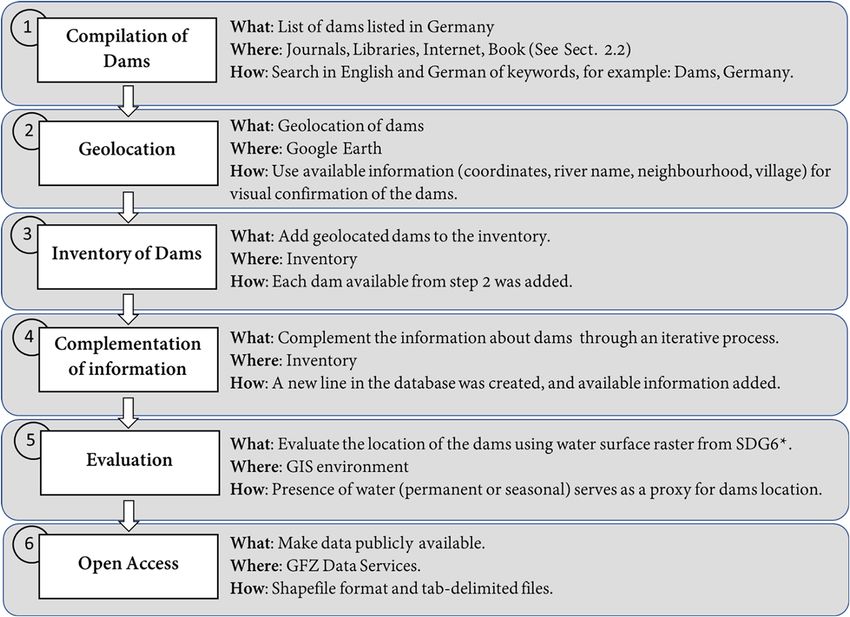
732                                                                     G. A. Speckhann et al.: Inventory of dams in Germany

rules, even though they may not provide the best answer for             Information and data about dams are crucial for dam oper-
multiple-purpose conflicts (Quinn et al., 2019).                     ators, scientists, and policymakers (Hecht et al., 2019; Tullos
   According to the International Commission on Large                et al., 2009), for instance, for the assessment of hydropower
Dams (ICOLD, 2019), the majority of dams throughout the              plant construction (Bertoni et al., 2019; Gernaat et al., 2017;
world serve irrigation purposes, in terms of both single-            Moran et al., 2018; Winemiller et al., 2016), estimation of the
purpose and multi-purpose dams. Irrigation represents the            hydrological footprint (Bakken et al., 2013, 2014; Popescu et
largest consumptive use of fresh water and is used on approx-        al., 2020; Postel, 2000), seasonal forecasting of water avail-
imately 20 % of the world’s agricultural land (World Com-            ability and water levels in rivers for navigation (Zhang et al.,
mission on Dams, 2000). Hydropower dams, the second most             2019), flood and drought risk assessment and management
common application, produce 72 % of global renewable en-             (Di Baldassarre et al., 2017; Ehsani et al., 2017; Elmer et al.,
ergy (Gernaat et al., 2017). Many countries aim to expand            2012; Metin et al., 2018; Veldkamp et al., 2017), and assess-
their hydropower potential in the near future (Bertoni et al.,       ment of biotic disturbances (Latrubesse et al., 2017; Maavara
2019; Timpe and Kaplan, 2017; Zarfl et al., 2014), especially        et al., 2020; Sabo et al., 2017). The consideration of dams in
due to its advantage in producing energy only when the elec-         hydrological models improves the model performance down-
trical system demands it (Zarfl et al., 2019). Pacific Asia,         stream (Gutenson et al., 2020), but the lack of information on
South America, and Africa have a significant potential for           dams may jeopardize model applications, especially at a na-
the construction of new hydropower plants (Gernaat et al.,           tional level (Zhao et al., 2020).
2017; Timpe and Kaplan, 2017), while in Europe and North                Important information about dams comprises the location
America, the current number of dams being built is smaller           of the dam, the lake area, and volume. Often it is also im-
than the number of dams being removed (Moran et al., 2018).          portant to know when a dam was constructed or went into
   In Germany, the first dams, i.e. fish and mill ponds with a       operation (and out of operation). The purpose of a dam is
small reservoir volume, are documented from the end of the           commonly known, but dam operation rules are hardly avail-
eighth century (Bettzieche, 2010). The construction of dams          able in dam databases. Dam operations are normally complex
gained importance when energy was needed for mining in               and influenced by environmental and anthropogenic factors
the Harz and Ore mountains in the mid-16th century. Mod-             (Gutenson et al., 2020). Many studies have explored the ef-
ern dam construction began with the Eschbach Dam (1891)              fects of dam operation rules; however, operation rules are not
and was driven by the goal of the industry in the low moun-          easily available for science, especially those of private hy-
tain range to remain competitive with the newly emerging in-         dropower plants (Bertoni et al., 2019; Giuliani et al., 2016;
dustry in the Ruhr area (Bettzieche, 2010). Later, other dam         Mediero et al., 2007; Pan et al., 2014; Quinn et al., 2019).
purposes such as flood control, recreation, and water sup-              In 1972, the congress of the United States of America au-
ply became much more important. Most of the dams in Ger-             thorized the first nationwide survey on dams, which was con-
many were built between 1950 and 2000 (Deutsche Talsper-             ducted by the US Army Corps of Engineers (US Army Corps
renKomitee e.V., 2013).                                              of Engineers, 1975). This was, to our knowledge, the first
   The construction of dams can lead to negative socio-              dam inventory conducted at a national level. Initially, the mo-
economic and environmental consequences (Best, 2019;                 tivation was to collect data on the dam hazard level (i.e. likely
Zarfl et al., 2019). The relocation of people and conflicts re-      life loss in case of dam failure), height, and storage capacity.
garding water use at different catchment locations can have a        This initiative continues until today, and the database cur-
long-term effect on communities. Dams, especially cascades           rently has information on more than 90 000 dams.
of dams, can be a threat to biodiversity and a driver of species        The Global Reservoir and Dam – GRanD – database
extinction (Winemiller et al., 2016) and are responsible for         (Lehner et al., 2011) was the first database to provide global
geochemical cycle modifications at the global level (Maavara         information about dams with a detailed level of information
et al., 2020). Dams can aggravate stress on rivers’ stream-          concerning location (municipality, country), dam height, sur-
flow by altering the hydrological regime (Bond et al., 2008;         face area, purpose, dam crest, and elevation. The first version
Zarfl et al., 2019; Zhang et al., 2019) and by modifying sed-        was made publicly available in 2011 with 6862 dams, and an
iment fluxes along the river (Maavara et al., 2020; Manh et          updated version was released in 2019 containing more than
al., 2015; Winemiller et al., 2016). For instance, in Brazil it is   7000 dams. Recently, the GlObal geOreferenced Databased
estimated that both the Paraná basin and the Tocantins basin         of Dams – GOODD (Mulligan et al., 2020) – was pub-
have a bedload trap of approximately 80 % (Latrubesse et al.,        lished, containing more than 38 000 dams (and their catch-
2005). In the Amazon River, one of the most explored areas           ments) across the whole globe. For the German territory, the
for hydropower plants, a reduction of 20 % of the suspended          GRanD database contains 60 dams, while GOODD contains
sediment has been observed (Latrubesse et al., 2017). Global         142 dams. As an outcome of the Sustainable Development
estimations indicate that the majority of large dams have a          Goal 6.6.1 the UN has freely provided GeoTIFF files for all
theoretical sediment trapping efficiency of higher than 50 %         administrative boundaries and basins indicating water sur-
(Vörösmarty et al., 2003).                                           face presence between the period of 2000–2018 at a reso-
                                                                     lution of 30 m. The products available are the result of a joint

Earth Syst. Sci. Data, 13, 731–740, 2021                                               https://doi.org/10.5194/essd-13-731-2021
G. A. Speckhann et al.: Inventory of dams in Germany 733
cooperation between the European Commission’s Joint Re- in the inventory. We have not established a threshold for the
search Centre and Google Earth. OpenStreetMap (OSM) is inclusion, e.g. based on dam height or lake volume, but we
also a freely available online tool that contains information have added only dams for which we could provide reliable
about dams globally. Through http://www.overpass-turbo.eu/ information. As such, we kept the database as useful as pos-
(last access: 25 February 2021), a web-based tool for filtering sible for different purposes.
OSM, one can easily identify the location of dams. In the fourth step different sources of information were
The objective of this work is to provide, as comprehen- combined to add the missing data to each dam entry. In
sively as possible, open-source information on dams in Ger- many cases the information was in agreement between dif-
many. We have compiled data from multiple sources, such as ferent sources. In the case of conflicting information, the fol-
federal-agency reports or scientific publications. Our main lowing hierarchy of information sources was applied taking
source was the German Committee on Large Dams (https: into consideration the perceived reliability of the sources:
//www.talsperrenkomitee.de, last access: 25 February 2021), (1) book of dams in Germany (Deutsche TalsperrenKomi-
especially their book published in 2013 which contains in- tee e.V., 2013), (2) state agency reports (e.g. Landesanstalt
formation on 340 dams (Deutsche TalsperrenKomitee e.V., für Umwelt Baden-Württemberg), (3) other dam databases
2013). We collected information about 530 dams in Ger- (Lehner et al., 2011; Mulligan et al., 2020), (4) engineering
many and individually identified their location using satel- reports, and (5) web pages. In order to have as much informa-
lite images from Google Earth. The database was evaluated tion as possible for each dam, the search was an iterative pro-
via a comparison with the available dam databases GRanD cess, where the priority rule was applied during every round.
(Lehner et al., 2011) and GOODD (Mulligan et al., 2020) and The fifth step was the evaluation of the dam’s location,
the Sustainable Development Goal 6 product (Pekel et al., and it was conducted as a validation. We used the location
2016). Our database contains significantly more dams than and persistence of surface water obtained from the anal-
the compilation of the German Committee on Large Dams ysis of Landsat satellite images (Pekel et al., 2016) as a
and combines different sources of information to provide de- proxy for the presence of the dam’s location. Using GIS soft-
tailed information that is herewith made freely available. ware, we compared the location of the dam with the wa-
ter surface occurrence by looking at the intersection of the
dam buffer and the water surface presence. We used the lat-
2 Material and methods
est available grid information on surface water, downloaded
2.1 Data compilation procedure
from the United Nations platform on Sustainable Develop-
ment Goal 6.6 (https://www.sdg661.app/downloads, last ac-
There are no agreed standards regarding the collection of cess: 25 February 2021), to indicate the presence of water
dam data. At a global level, there are only two open-access and therefore confirm that a water surface was spotted at the
data publications on dams (Lehner et al., 2011; Mulligan et dam’s location.
al., 2020). In order to create a national dam inventory for The last step was to make the inventory publicly avail-
Germany (DIG), we followed six steps (Fig. 1). The first able at GeoForschungsZentrum (GFZ) Data Services (http:
step was to search for information about dams across a va- //dataservices.gfz-potsdam.de/portal/, last access: 25 Febru-
riety of sources: books, journals, federal-agency reports, and ary 2021), where a shapefile and tab-delimited file containing
web pages. We searched for any reference in English or Ger- all information can be downloaded.
man that may lead to some information about dams in Ger-
many. We have searched for any reference to “dams” and/or 2.2 Data sources
“Germany” in libraries and on internet search engines. This
yielded a considerable number of possible sources. The most The information available was classified into five main
comprehensive source was the book Talsperren in Deutsch- sources as described under step 4 and listed in detail
land (Deutsche TalsperrenKomitee e.V., 2013) from where a in Table 1. The book of dams in Germany (Deutsche
significant part of the data in this inventory were obtained. TalsperrenKomitee e.V., 2013) is the most detailed in-
In the second step, the dams were geolocated using satel- formation source providing technical information for 350
lite images. Only dams that could be identified visually were dams in Germany. State agency reports with dam infor-
included in our database. The identification was carried out mation are available from all states in Germany, except
using Google Earth, based on the combination of the name for Saarland, Rhineland-Palatinate, Schleswig-Holstein, and
of the dam and the city where it was located. For those cases Mecklenburg-Western Pomerania. A possible explanation for
where a dam could not be identified, additional information that fact is the smaller number of dams in those states. On the
on the dam location was used to increase the chance of find- other hand, Baden-Württemberg, North Rhine-Westphalia,
ing it (e.g. name of the river, neighbourhood, image). and Bavaria provide dam information on the websites of their
All identified dams were included in the inventory with environmental agencies. The two global databases tend to fo-
their name and coordinates (step 3). The dam coordinates cus on big dams using automated algorithms for reservoir
were a condition sine qua non for the inclusion of the dam identification based on topography. The GRanD database by
https://doi.org/10.5194/essd-13-731-2021 Earth Syst. Sci. Data, 13, 731–740, 2021734 G. A. Speckhann et al.: Inventory of dams in Germany
Figure 1. Procedure for the compilation of the dam inventory. * Sustainable Development Goal 6 app (https://www.sdg661.app/
data-products/data-downloads, last access: 25 February 2021).
Lehner et al. (2011) is the second most complete set of dam 3 Results
information for Germany, containing information of geoloca-
tion, dam height, purpose, and lake area for 60 dams in Ger- 3.1 Data contents
many. GOODD (Mulligan et al., 2020) covers 142 dams in
Our dam inventory contains the following: name of the dam,
Germany but contains no information apart from the geolo-
date when the construction and operation started, state, river,
cation and watershed size. The global databases are the only
length of the crest, height of the wall, area of the lake at full
information that can be used directly in a GIS environment
capacity, volume at full capacity, dam type, building charac-
and provide coordinates for each dam. The information apart
teristics, and geolocation (Table 2). Information on the type,
from that of the global databases is only available as docu-
building characteristics and purpose is given using abbrevi-
ment pages that cannot be exported to a user-friendly format;
ations; a table containing these abbreviations is provided in
the use of this information requires copying the information
the folder for download. We have compiled the most com-
manually for each dam. Some of the information from state
prehensive dam inventory for Germany; however, we believe
agency files (tables, texts) is protected and does not allow
that there are more dams in Germany that for many reasons
any selection. Engineering reports are normally available for
were not identified via our procedure. Hence, there is room
more recent dams or for dams that have been under restora-
for expanding our inventory.
tion or retrofitting, e.g. to increase dam capacity. Web pages
are also a source of dam information. However, verifiable ref-
erences or links are often missing, and in some occasions dif- 3.2 Data characteristics
ferences in naming the dams occurred. Hence, we decided to
avoid web pages as the main information source of a dam. Our dam inventory comprises information about 530 dams
Their information was used as complementary data and was which are in operation in Germany (Fig. 2). Saxony is the
combined with other sources. Table 1 presents the most rele- state with the highest number of dams in our inventory with
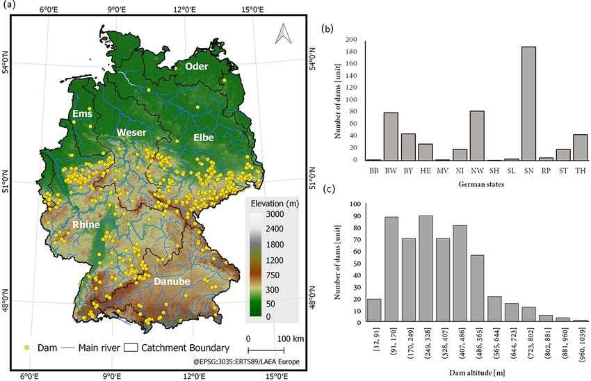
vant sources of information used to compile the DIG. a total of 190 dams. North Rhein-Westphalia is the second
one with 83 dams, followed by Baden-Württemberg with
79. For the city states of Berlin, Bremen, and Hamburg no
dams were found. Brandenburg (2), Mecklenburg-Western
Pomerania (2), Rhineland-Palatinate (4), Saarland (3), and
Schleswig-Holstein (1) have a small number of dams (Fig. 2).
These states are located at a lower elevation. The majority of
dams in the remaining states of Thuringia (43), Bavaria (44),
Earth Syst. Sci. Data, 13, 731–740, 2021 https://doi.org/10.5194/essd-13-731-2021G. A. Speckhann et al.: Inventory of dams in Germany 735
Table 1. The most relevant sources of information used to compile the DIG.
Source of information Information contained Number Format Region
of dams in availability
Germany
Deutsches TalsperrenKomitee Name of the dam, start of operation, 348 Book (table) Germany
e.V. state, river name, dam height, lake area,
lake volume, construction type, build-
ing characteristics
Bayerisches Landesamt für Name of the dam, start of operation, 24 Internet page Bavaria
Umwelt state, river name, crest length, dam
height, lake area, lake volume, con-
struction type, purpose, building char-
acteristics, coordinates
Hessisches Ministerium für Name of the dam, start of operation, 45 Table (PDF) Hesse
Umwelt, Klimaschutz, Land- state, river name, lake area, lake volume
wirtschaft und Verbraucher-
schutz
Landesamt für Natur, Umwelt Name of the dam, start of operation, 44 Table (PDF) North Rhine-
und Verbraucherschutz state, crest length, lake volume, opera- Westphalia
Nordrhein-Westfalen tor or responsible organization
Landesamt für Umwelt Name of the dam, start of operation, 2 Internet page Brandenburg
Brandenburg state, river name, dam height, lake vol-
ume, purpose, building characteristics
Landesanstalt für Umwelt Name of the dam, start of operation, 80 Table (PDF) Baden-
Baden-Württemberg state, river name, crest length, dam Württemberg
height, lake area, lake volume, con-
struction type, purpose, building char-
acteristics
Niedersächsischer Landes- Name of the dam, state, river name, lake 12 Internet page Lower Saxony
betrieb für Wasserwirtschaft, area, lake volume, purpose
Küsten- und Naturschutz
Sächsisches Landesamt Name of the dam, start of operation, 162 Table (PDF) Saxony
für Umwelt, Landwirtschaft state, river name, crest length, dam
und Geologie, height, lake area, lake volume, con-
Abteilung Wasser struction type, purpose, building char-
acteristics, operator or responsible or-
ganization
Talsperrenbetrieb Name of the dam, start of operation, 32 Internet page Saxony-Anhalt
Sachsen-Anhalt state, river name, dam height, lake vol-
ume, purpose
Thüringer Fernwasser- Name of the dam, start of operation, 7 Internet page Thuringia
versorgung state, river name, crest length, dam
height, lake area, lake volume, con-
struction type, purpose, building char-
acteristics,
GOODD (Mulligan et al., 2020) Geolocation, watershed, size 142 Paper (shape- Global
file available)
GRanD database (Lehner et al., Name of the dam, start of operation, 60 Paper (shape- Global
2011) state, river name, crest length, dam file available)
height, lake area, lake volume, con-
struction type, purpose, geolocation,
watershed size
https://doi.org/10.5194/essd-13-731-2021 Earth Syst. Sci. Data, 13, 731–740, 2021736 G. A. Speckhann et al.: Inventory of dams in Germany
Table 2. Data present in the dam inventory with units.
Variable Unit Description
Name – Name of the dam
Start date of construction – Year in which dam construction started (YYYY)
Date of operation – Year in which the construction was finished (YYYY)
State – Represented by two letters (e.g. BY for Bavaria)
River – Name of the river where the dam is located or which it is close to
Crest length m Length of the dam crest
Dam height m Dam height from base to top
Lake area km2 Lake area at full capacity
Lake volume million m3 Lake volume at full capacity
Construction type – Type of structure (e.g. barrage, pond)
Purpose – Dam function(s) (e.g. flood control, energy production)
Building characteristics – Structural dam characteristics (e.g. embankment dam)
Location – Geometric coordinates using WGS84
Saxony-Anhalt (32), Hesse (28), and Lower Saxony (19) are where dams can be constructed and (2) the chance of struc-
located at an altitude between 100 and 500 m. The number tural failure associated with the dam existence and operation.
of dams is a function of the data availability; i.e. states may Dam height is one of the criteria used to classify dams. The
have more dams on their territory, but the information was International Commission on Large Dams (ICOLD, 2011)
not publicly available or the dam was not detected by satel- defines dams with heights above 15 m as large dams. A to-
lite image algorithms. We do not claim to have compiled an tal of 266 dams (50 %) in our inventory are considered large
exhaustive list of all dams in Germany. dams (Fig. 5b). We could not observe a relation between dam
Our inventory contains 276 single-purpose dams and 254 height and the states.
multi-purpose dams. Flood control (HWS) is the most com- There are 231 dams (43 %) with a lake volume smaller
mon purpose (Fig. 3a) often in combination with other pur- than 1×10⁶ m3 . Dams tend to be decentralized; i.e. there tend
poses. Only 36 % of 284 dams with a flood control function to be several smaller dams which may act together, instead of
are used exclusively for flood control. Recreation (NEG) is one massive dam, within a region. The DIG has 11 dams with
the second most common purpose with 179 dams, and the a lake volume higher than 100 × 106 m3 , and the majority
majority (86 %) are multi-purpose dams. Energy production of them were constructed for energy production and flood
(E) is also widespread with 131 dams. A total of 23 dams are control.
used for nature protection (NSG). In order to assure a min-
imum level of navigability on waterways, especially during
summertime, 62 dams are used to regulate the river water 3.3 Evaluation of location of dams
level for transport reasons (NWA). Our inventory contains Dam location is central in our inventory, so we evaluated it
130 dams for water supply (TWv) which are spread across using global data. We used water surface raster information
the country. Industrial and agricultural water supply (BWv) for the year 2018 (Pekel et al., 2016) as a proxy for the lo-
are an important component for food (e.g. irrigation) and en- cation of active dams. This raster is derived from Landsat
ergy production (e.g. cooling of nuclear power plants) and images; however, they may not be able to correctly iden-
other industry-related activities with 91 dams. tify dams with a lake area smaller than 0.3 km2 and lake
The building characteristics are dominated by three types: width smaller than 30 m (Lehner et al., 2011; Mulligan et al.,
embankment dams, gravity dams, and rockfill dams (Fig. 3b). 2020). For each dam in the inventory, we created a buffer of
Embankment dams (EDDs) are by far the most frequent type 200 m around a point and used that polygon as a mask to ex-
(289 dams, 54 %), followed by gravity dams (97 dams, 18 %) tract the values from the 30 m resolution water surface raster.
and rockfill dams (75 dams, 14 %). No relation was observed The raster contains three possible states: “permanent water”,
between the building characteristics and the states. “seasonal water”, and “no water”. Each dam location was in-
After the Second World War, many countries initiated the vestigated for the presence of permanent water or seasonal
construction of dams with a particularly strong increase in water for the year 2018.
Europe and the USA between 1950 and 2000 (Moran et al., From the 530 dams in the inventory, 81 dams did not ex-
2018). This trend is also seen in Germany (Fig. 4). Between hibit the presence of water (permanent or seasonal). Of those
1950 and 2000 more than 300 dams were constructed, but dams, 63 are classified as single-purpose dams for flood con-
only 20 dams after 2000 were built. The reasons for this re- trol. The majority of the remaining dams (14 out of 18 dams)
duction are twofold: (1) the decrease in available locations are used for flood control together with other purposes and
Earth Syst. Sci. Data, 13, 731–740, 2021 https://doi.org/10.5194/essd-13-731-2021G. A. Speckhann et al.: Inventory of dams in Germany 737
Figure 2. Dam locations across Germany (a), number of dams in the German states (b), and dam altitude (c). State abbreviations are BB
(Brandenburg), BW (Baden-Württemberg), BY (Bavaria), HE (Hesse), MV (Mecklenburg-Western Pomerania), NI (Lower Saxony), NW
(North Rhein-Westphalia), SH (Schleswig-Holstein), SL (Saarland), SN (Saxony), RP (Rhineland-Palatinate), ST (Saxony-Anhalt), and TH
(Thuringia).
Figure 3. Dam purpose (a) and building characteristics (b). Purposes are abbreviated as BWv (industrial agricultural water supply), E
(energy production), F (fishing), HWS (flood control), NEG (recreational), NSG (nature protection), NWA (transport), and TWv (water
supply). Building characteristics are abbreviated as BSM (arch dam), EDD (embankment dam), EHD (homogenous rockfill dam), GWD
(gravity dam), KW (flap weir), PFM (buttress dam), RGD (ring dam), SD (fill dam), SFK (segment with fish belly flap), STD (rockfill dam),
TG (residual lake associated with mining), WZW (rolling weir), and ZND (zone dam).
have a lake area smaller than the threshold for lake identi- 4 Data availability
fication (0.3 km2 ). As single-purpose flood control dams are
only used in flood situations, it is expected that most of them The data can be freely downloaded via GFZ Data Services at
are not identified by a satellite-derived water surface product https://doi.org/10.5880/GFZ.4.4.2020.005 (Speckhann et al.,
for a given year, as they may not have experienced a flood sit- 2020).
uation in that year or due to cloud interference during floods.
Thus, we believe that our evaluation of the dam location is
sufficient for compiling the dam inventory. 5 Conclusions
We have compiled an open-access inventory of dams at the
national level in Germany. This information can be used by
scientists, practitioners, and policymakers for a range of pur-
poses, such as flood and drought risk assessment and man-
agement or assessment of biotic disturbances. We have built
https://doi.org/10.5194/essd-13-731-2021 Earth Syst. Sci. Data, 13, 731–740, 2021738 G. A. Speckhann et al.: Inventory of dams in Germany
Figure 4. Construction year of the dams in Germany (a) and a subplot for the period between 1950–2015 (b).
Figure 5. Lake volume (a) and dam height (b).
the most comprehensive inventory of dams in Germany by Competing interests. The authors declare that they have no con-
providing the name of the dam, the name of the river, and flict of interest.
technical specifications (dam height, crest length, building
characteristics, purpose, and type) as well as the dam ge-
olocation. With information about 530 dams, our inventory Acknowledgements. The first author would like to thank the
comprises almost 1.5 times the number of dams than the sec- German Academic Exchange Service (DAAD) for financial support
ond most comprehensive source, i.e. the book of the German during the research.
Committee on Large Dams. As states in Germany advance
their use of digitalization together with public administra-
Financial support. This research has been supported by the
tive transparency, we believe that there will be opportunities
Deutscher Akademischer Austauschdienst (grant no. 57399578).
for the DIG to be updated and extended in the future, in re-
spect of both the number of dams and the amount of infor-
mation. Further useful extensions of the inventory may also Review statement. This paper was edited by David Carlson and
include dams in upstream regions of the Elbe, Rhine, and reviewed by Benjamin Fersch and one anonymous referee.
Danube catchments outside Germany, since these also influ-
ence the hydrology in Germany. The DIG consists of a shape-
file format which enables the easy use of this information in
GIS environments and modelling applications and also a tab- References
delimited file that can be easily imported for other uses.
Bakken, T. H., Killingtveit, Å., Engeland, K., Alfredsen, K., and
Harby, A.: Water consumption from hydropower plants – review
Author contributions. GAS, HK, and BM designed the study, of published estimates and an assessment of the concept, Hydrol.
and GAS carried it out. GAS prepared the manuscript with valu- Earth Syst. Sci., 17, 3983–4000, https://doi.org/10.5194/hess-17-
able contributions from all co-authors. 3983-2013, 2013.
Bakken, T. H., Aase, A. G., Hagen, D., Sundt, H., Barton, D. N.,
and Lujala, P.: Demonstrating a new framework for the compar-
ison of environmental impacts from small- and large-scale hy-
Earth Syst. Sci. Data, 13, 731–740, 2021 https://doi.org/10.5194/essd-13-731-2021G. A. Speckhann et al.: Inventory of dams in Germany 739 dropower and wind power projects, J. Environ. Manage., 140, treme flood hazard events in Kerala, India, Remote Sens. Lett., 93–101, https://doi.org/10.1016/j.jenvman.2014.01.050, 2014. 11, 436–445, https://doi.org/10.1080/2150704X.2020.1730468, Di Baldassarre, G., Martinez, F., Kalantari, Z., and Viglione, 2020. A.: Drought and flood in the Anthropocene: feedback mecha- Latrubesse, E. M., Stevaux, J. C., and Sinha, R.: nisms in reservoir operation, Earth Syst. Dynam., 8, 225–233, Tropical rivers, Geomorphology, 70, 187–206, https://doi.org/10.5194/esd-8-225-2017, 2017. https://doi.org/10.1016/j.geomorph.2005.02.005, 2005. Bertoni, F., Castelletti, A., Giuliani, M., and Reed, P. M.: Latrubesse, E. M., Arima, E. Y., Dunne, T., Park, E., Baker, Discovering Dependencies, Trade-Offs, and Robustness in V. R., D’Horta, F. M., Wight, C., Wittmann, F., Zuanon, Joint Dam Design and Operation: An Ex-Post Assess- J., Baker, P. A., Ribas, C. C., Norgaard, R. B., Filizola, ment of the Kariba Dam, Earths Future, 7, 1367–1390, N., Ansar, A., Flyvbjerg, B., and Stevaux, J. C.: Damming https://doi.org/10.1029/2019EF001235, 2019. the rivers of the Amazon basin, Nature, 546, 363–369, Best, J.: Anthropogenic stresses on the world’s big rivers, Nat. https://doi.org/10.1038/nature22333, 2017. Geosci., 12, 7–21, https://doi.org/10.1038/s41561-018-0262-x, Lehner, B., Liermann, C. R., Revenga, C., Vörömsmarty, C., Fekete, 2019. B., Crouzet, P., Döll, P., Endejan, M., Frenken, K., Magome, J., Bettzieche, V.: 100 Jahre technische entwicklung des talsperrenbaus Nilsson, C., Robertson, J. C., Rödel, R., Sindorf, N., and Wisser, in Deutschland, Wasserwirtschaft, 1–2, 67–72, 2010 (in Ger- D.: High-resolution mapping of the world’s reservoirs and dams man). for sustainable river-flow management, Front. Ecol. Environ., 9, Bond, N. R., Lake, P. S., and Arthington, A. H.: The impacts of 494–502, https://doi.org/10.1890/100125, 2011. drought on freshwater ecosystems: An Australian perspective, Maavara, T., Chen, Q., Van Meter, K., Brown, L. E., Zhang, Hydrobiologia, 600, 1–14, https://doi.org/10.1007/s10750-008- J., Ni, J., and Zarfl, C.: River dam impacts on biogeo- 9326-z, 2008. chemical cycling, Nat. Rev. Earth Environ., 1, 103–116, Deutsche TalsperrenKomitee e. V.: Talsperren in Deutschland, 1st https://doi.org/10.1038/s43017-019-0019-0, 2020. ed., edited by DTK, Springer Vieweg, Dresden, 2013 (in Ger- Manh, N. V., Dung, N. V., Hung, N. N., Kummu, M., Merz, man). B., and Apel, H.: Future sediment dynamics in the Mekong Ehsani, N., Vörösmarty, C. J., Fekete, B. M., and Stakhiv, E. Delta floodplains: Impacts of hydropower development, climate Z.: Reservoir operations under climate change: Storage ca- change and sea level rise, Glob. Planet. Change, 127, 22–33, pacity options to mitigate risk, J. Hydrol., 555, 435–446, https://doi.org/10.1016/j.gloplacha.2015.01.001, 2015. https://doi.org/10.1016/j.jhydrol.2017.09.008, 2017. Mediero, L., Garrote, L., and Martín-Carrasco, F.: A prob- Elmer, F., Hoymann, J., Düthmann, D., Vorogushyn, S., and abilistic model to support reservoir operation deci- Kreibich, H.: Drivers of flood risk change in residen- sions during flash floods, Hydrol. Sci. J., 52, 523–537, tial areas, Nat. Hazards Earth Syst. Sci., 12, 1641–1657, https://doi.org/10.1623/hysj.52.3.523, 2007. https://doi.org/10.5194/nhess-12-1641-2012, 2012. Metin, A. D., Dung, N. V., Schröter, K., Guse, B., Apel, H., Gernaat, D. E. H. J., Bogaart, P. W., Vuuren, D. P. V., Biemans, H., Kreibich, H., Vorogushyn, S., and Merz, B.: How do changes and Niessink, R.: High-resolution assessment of global technical along the risk chain affect flood risk?, Nat. Hazards Earth and economic hydropower potential, Nat. Energy, 2, 821–828, Syst. Sci., 18, 3089–3108, https://doi.org/10.5194/nhess-18- https://doi.org/10.1038/s41560-017-0006-y, 2017. 3089-2018, 2018. Giuliani, M., Castelletti, A., Pianosi, F., Mason, E., and Reed, P. Moran, E. F., Lopez, M. C., Moore, N., Müller, N., and M.: Curses, tradeoffs, and scalable management: Advancing evo- Hyndman, D. W.: Sustainable hydropower in the 21st lutionary multiobjective direct policy search to improve water century, Proc. Natl. Acad. Sci. USA, 115, 11891–11898, reservoir operations, J. Water Resour. Plan. Manag., 142, 1–17, https://doi.org/10.1073/pnas.1809426115, 2018. https://doi.org/10.1061/(ASCE)WR.1943-5452.0000570, 2016. Mulligan, M., van Soesbergen, A., and Sáenz, L.: GOODD, a global Gutenson, J. L., Tavakoly, A. A., Wahl, M. D., and Follum, M. L.: dataset of more than 38,000 georeferenced dams, Sci. Data, 7, 1– Comparison of generalized non-data-driven lake and reservoir 8, https://doi.org/10.1038/s41597-020-0362-5, 2020. routing models for global-scale hydrologic forecasting of reser- Pan, T. Y., Chang, L. Y., Lai, J. S., Chang, H. K., Lee, C. S., and voir outflow at diurnal time steps, Hydrol. Earth Syst. Sci., 24, Tan, Y. C.: Coupling typhoon rainfall forecasting with overland- 2711–2729, https://doi.org/10.5194/hess-24-2711-2020, 2020. flow modeling for early warning of inundation, Nat. Hazards, 70, Hecht, J. S., Lacombe, G., Arias, M. E., Dang, T. D., and Pi- 1763–1793, https://doi.org/10.1007/s11069-011-0061-9, 2014. man, T.: Hydropower dams of the Mekong River basin: A re- Pekel, J. F., Cottam, A., Gorelick, N., and Belward, A. view of their hydrological impacts, J. Hydrol., 568, 285–300, S.: High-resolution mapping of global surface wa- https://doi.org/10.1016/j.jhydrol.2018.10.045, 2019. ter and its long-term changes, Nature, 540, 418–422, ICOLD: Constitution of ICOLD, Int. Comm. Large Dams, 2, 1– https://doi.org/10.1038/nature20584, 2016. 21, available at: http://www.icold-cigb.org/userfiles/files/CIGB/ Poff, N. L. R. and Olden, J. D.: Can dams be de- INSTITUTIONAL_FILES/Constitution2011.pdf (last access: 24 signed for sustainability?, Science, 358, 1252–1253, February 2021), 2011. https://doi.org/10.1126/science.aaq1422, 2017. ICOLD: International Commision on Large Dams – General Popescu, V. D., Munshaw, R. G., Shackelford, N., Montesino Synthesis, available at: https://www.icold-cigb.org/GB/world_ Pouzols, F., Dubman, E., Gibeau, P., Horne, M., Moilanen, A., register/general_synthesis.asp (last access: 20 May 2020), 2019. and Palen, W. J.: Quantifying biodiversity trade-offs in the face Lal, P., Prakash, A., Kumar, A., Srivastava, P. K., Saikia, P., Pandey, of widespread renewable and unconventional energy develop- A. C., Srivastava, P., and Khan, M. L.: Evaluating the 2018 ex- https://doi.org/10.5194/essd-13-731-2021 Earth Syst. Sci. Data, 13, 731–740, 2021
740                                                                          G. A. Speckhann et al.: Inventory of dams in Germany

  ment, Sci. Rep.-UK, 10, 1–12, https://doi.org/10.1038/s41598-          Veldkamp, T. I. E., Wada, Y., Aerts, J. C. J. H., Döll, P., Gosling, S.
  020-64501-7, 2020.                                                       N., Liu, J., Masaki, Y., Oki, T., Ostberg, S., Pokhrel, Y., Satoh,
Postel, S. L.: Entering an era of water scarcity: The challenges           Y., Kim, H., and Ward, P. J.: Water scarcity hotspots travel down-
  ahead, Ecol. Appl., 10, 941–948, https://doi.org/10.1890/1051-           stream due to human interventions in the 20th and 21st century,
  0761(2000)010[0941:EAEOWS]2.0.CO;2, 2000.                                Nat. Commun., 8, 1–12, https://doi.org/10.1038/ncomms15697,
Quinn, J. D., Reed, P. M., Giuliani, M., and Castelletti, A.:              2017.
  What Is Controlling Our Control Rules? Opening the Black               Vörösmarty, C. J., Meybeck, M., Fekete, B., Sharma, K., Green,
  Box of Multireservoir Operating Policies Using Time-Varying              P., and Syvitski, J. P. M.: Anthropogenic sediment retention:
  Sensitivity Analysis, Water Resour. Res., 55, 5962–5984,                 Major global impact from registered river impoundments, Glob.
  https://doi.org/10.1029/2018WR024177, 2019.                              Planet. Change, 39, 169–190, https://doi.org/10.1016/S0921-
Sabo, J. L., Ruhi, A., Holtgrieve, G. W., Elliott, V., Arias, M. E.,       8181(03)00023-7, 2003.
  Ngor, P. B., Räsänen, T. A., and Nam, S.: Designing river flows to     Winemiller, K. O., McIntyre, P. B., Castello, L., Fluet-Chouinard,
  improve food security futures in the Lower Mekong Basin, Sci-            E., Giarrizzo, T., Nam, S., Baird, I. G., Darwall, W., Lujan, N.
  ence, 358, eaao1053, https://doi.org/10.1126/science.aao1053,            K., Harrison, I., Stiassny, M. L. J., Silvano, R. A. M., Fitzger-
  2017.                                                                    ald, D. B., Pelicice, F. M., Agostinho, A. A., Gomes, L. C., Al-
Sordo-Ward, A., Garrote, L., Martín-Carrasco, F., and Do-                  bert, J. S., Baran, E., Petrere, M., Zarfl, C., Mulligan, M., Sulli-
  lores Bejarano, M.: Extreme flood abatement in large dams                van, J. P., Arantes, C. C., Sousa, L. M., Koning, A. A., Hoeing-
  with fixed-crest spillways, J. Hydrol., 466–467, 60–72,                  haus, D. J., Sabaj, M., Lundberg, J. G., Armbruster, J., Thieme,
  https://doi.org/10.1016/j.jhydrol.2012.08.009, 2012.                     M. L., Petry, P., Zuanon, J., Torrente Vilara, G., Snoeks, J., Ou,
Sordo-Ward, A., Garrote, L., Bejarano, M. D., and Castillo,                C., Rainboth, W., Pavanelli, C. S., Akama, A., Van Soesber-
  L. G.: Extreme flood abatement in large dams with                        gen, A., and Sáenz, L.: Balancing hydropower and biodiversity
  gate-controlled spillways, J. Hydrol., 498, 113–123,                     in the Amazon, Congo, and Mekong, Science, 351, 128–129,
  https://doi.org/10.1016/j.jhydrol.2013.06.010, 2013.                     https://doi.org/10.1126/science.aac7082, 2016.
Speckhann, G. A., Kreibich, H., and Merz, B.: Inven-                     World Commission on Dams: Dams and development: A new
  tory of dams in Germany, V. 1.0, GFZ Data Services,                      framework for decision-making Overview of the report by the
  https://doi.org/10.5880/GFZ.4.4.2020.005, 2020.                          World Commission on Dams, Routledge, London, 446 pp., 2000.
Timpe, K. and Kaplan, D.: The changing hydrol-                           Zarfl, C., Lumsdon, A. E., Berlekamp, J., Tydecks, L., and Tockner,
  ogy of a dammed Amazon, Sci. Adv., 3, 1–14,                              K.: A global boom in hydropower dam construction, Aquat. Sci.,
  https://doi.org/10.1126/sciadv.1700611, 2017.                            77, 161–170, https://doi.org/10.1007/s00027-014-0377-0, 2014.
Tullos, D., Tilt, B., and Liermann, C. R.: Introduction to the special   Zarfl, C., Berlekamp, J., He, F., Jähnig, S. C., Darwall,
  issue: Understanding and linking the biophysical, socioeconomic          W., and Tockner, K.: Future large hydropower dams im-
  and geopolitical effects of dams, J. Environ. Manage., 90, 1–5,          pact global freshwater megafauna, Sci. Rep.-UK, 9, 1–10,
  https://doi.org/10.1016/j.jenvman.2008.08.018, 2009.                     https://doi.org/10.1038/s41598-019-54980-8, 2019.
US Army Corps of Engineers: National program of inspection of            Zhang, Y., Zheng, H., Herron, N., Liu, X., Wang, Z., Chiew, F. H.
  dams, [Department of Defense], Department of the Army, Of-               S., and Parajka, J.: A framework estimating cumulative impact
  fice of the Chief of Engineers, Washington, DC, available at:            of damming on downstream water availability, J. Hydrol., 575,
  https://books.google.de/books?id=1QtaKF0RiJgC (last access:              612–627, https://doi.org/10.1016/j.jhydrol.2019.05.061, 2019.
  24 February 2021), 1975.                                               Zhao, G., Bates, P., and Neal, J.: The Impact of Dams on Design
                                                                           Floods in the Conterminous US, Water Resour. Res., 56, 1–15,
                                                                           https://doi.org/10.1029/2019WR025380, 2020.

Earth Syst. Sci. Data, 13, 731–740, 2021                                                    https://doi.org/10.5194/essd-13-731-2021
You can also read