IPPERWASH COMMISSION OF INQUIRY HISTORICAL BACKGROUND - Prepared by Joan Holmes & Associates, Inc. for The Ipperwash Commission of Inquiry June 2004
←
→
Page content transcription
If your browser does not render page correctly, please read the page content below
IPPERWASH COMMISSION OF INQUIRY
       HISTORICAL BACKGROUND

Prepared by Joan Holmes & Associates, Inc. for
    The Ipperwash Commission of Inquiry

                  June 2004
IPPERWASH COMMISSION OF INQUIRY
HISTORICAL BACKGROUND
TABLE OF CONTENTS
Overview................................................................................................................................... 3
Plan #1 Huron Tract Purchase.................................................................................................. 7
Plan #2 Location Of Reserves Set Aside Under Treaty .............................................................. 8
Plan #3 Surrenders from the Kettle and Stoney Point Reserves ................................................... 9
Background History of Kettle and Stony Point ......................................................................... 10
British Indian Policy.................................................................................................... 10
The Huron Tract Treaty ............................................................................................... 11
th
Early 19 Century Indian Department Administration.................................................. 18
th
Early 19 Century Communities .................................................................................. 19
The Seeds of Discontent........................................................................................................... 23
The “American Indians” Debate................................................................................... 23
Proposed Subdivision Survey and Beginning of Movement for the Separation of the
Sarnia and Kettle and Stony Point Bands ..................................................................... 28
Renewed Attempts at Survey ....................................................................................... 30
Final Survey of Kettle and Stony Point Reserves ......................................................... 31
Removal of U.S. Potawatomis from Stony Point Reserve ............................................ 32
Administrative Separation from the Sarnia Band.......................................................... 35
Land Surrenders on Kettle and Stony Point .............................................................................. 38
Shoreline Taking at Kettle Point .................................................................................. 38
Shoreline Taking at Stony Point .................................................................................. 42
Establishment of Ipperwash Provincial Park ................................................................ 43
66 Foot Shore Line Allowance .................................................................................... 44
Other Surrenders of Kettle and Stony Point Resources................................................. 46
Appropriation by the Department of National Defence, 1942.................................................... 48
Department of National Defence Appropriation of the remainder of the Stony Point
waterfront lots, 1944.................................................................................................... 54
Grievances Regarding Burial Ground and Responses................................................................ 55
Burial Ground, Ipperwash Provincial Park ................................................................... 55
Burial ground, Camp Ipperwash .................................................................................. 56
Other Possible Grave Sites at Stony Point and Kettle Point.......................................... 58
Attempts at the Return of Camp Ipperwash And Present Day Situation..................................... 59
Occupation of Camp Ipperwash ................................................................................... 62
Occupation of Ipperwash Provincial Park .................................................................... 65
Present Day Situation .................................................................................................. 66
Concluding Summary .............................................................................................................. 68
Bibliography of Secondary Sources.......................................................................................... 71
Appendix A Glossary Of Terms.............................................................................................. 73
Appendix B Chiefs’ Names and Totems ................................................................................. 79
Appendix C Text of Surrender #29, July 10, 1827.................................................................. 82
Appendix D Selected Population Statistics .............................................................................. 85
Joan Holmes & Associates Inc. 2 Draft Printed June 25, 2004OVERVIEW
The ancestors of the Kettle Point and Stony1 Point people were Chippewa and Potawatomi living
around the River St. Clair and Lake Huron and environs at the time of the British conquest in the
mid-18th century. They entered into a peaceful alliance with the British in the 1760s and assisted
them as military allies in subsequent conflicts including the War of 1812.
th
In the early 19 century the British wanted to purchase the land around Lake Huron north of the
Thames River for white settlement. Following the rules set out in the Royal Proclamation of
1763 they met in council with the Chippewa of the region to discuss acquisition of the land. A
land cession treaty was negotiated over a nine-year period culminating in the Huron Tract Treaty
of 1827. Over two million acres of land was ceded to the Crown. In return the Chippewas of
Chenail Ecarte (Walpole Island), River St. Clair (Sarnia) and River Aux Sauble (Kettle and
Stony Point) were granted a perpetual annuity. Four reserves, comprising less than 1 per cent of
the land, were reserved out of the cession in locations chosen by the Chippewas. Two were
located on the St. Clair River (Sarnia and Moore Township2) and two on Lake Huron (Kettle
Point and Stony Point). The reserve at Sarnia was more than 10,000 acres, while the three other
reserves were approximately 2,500 acres each. An “Indian refuge” already existed at Walpole
Island.
th
The Indian Department, which had been created in the mid-18 century to manage the
relationship between the British Crown and the Indian nations, became increasingly involved in
administering the affairs of the Huron Tract Chippewa. Some of the systems imposed on the
groups caused tension and strife within the communities as it dictated how they had to relate to
each other and restricted the way in which they could deal with their resources, particularly their
reserve land. Two of the major causes of conflict were the integration of Potawatomis and other
nations from the United States into the communities and the treatment of the groups as one large
regional band with a common and undivided interest in the treaty annuity, reserve land and any
funds that were raised from the sale or lease of land and resources.
The issue of the so-called “American Indians” had its genesis in early British Indian policy and
th
historical circumstances dating to the late 19 century. The British had formed military and trade
alliances with Indian nations throughout the Great Lakes area. As a symbol of their alliance they
distributed presents, known as His/Her Majesty’s bounty, to their Indian allies on an annual
basis. A decade after the American Revolution the British gave up their posts on the American
side of the international boundary and groups of Potawatomi, Chippewa and Ottawa immigrated
onto British soil at the invitation of their British allies. The last major wave of immigration took
place in the 1840s after the British announced that they would no longer issue annual presents to
anyone still living on the American side of the boundary. They had assured those who chose to
immigrate that they would continue to receive Her Majesty’s annual bounty. Many of the
immigrant Potawatomi and Chippewa moved onto Walpole Island and the Huron Tract reserves
as they were already connected to those people by long association.
The Indian Department treated the signatories of the Huron Tract Treaty as one large band who
shared in the annuities and reserves flowing from the treaty, despite the fact that they had a
1 Spelled variously in the documents as Stoney and Stony.
2 The Moore Township Reserve was surrendered in 1843 by the Walpole and St. Clair Band.
Joan Holmes & Associates Inc. 3 Draft Printed June 25, 2004history of managing their own affairs independent of one another and lived some distance apart. In addition, the people at Upper St. Clair River (Sarnia) far outnumbered those at Kettle Point and Stony Point. As a result they had very little influence in the joint council and the Sarnia portion of the Band had effective control over land and resources at Kettle and Stony Point. The Walpole Island people wanted to separate themselves from the Sarnia and Kettle and Stony Point people. Although they agreed as early as 1836 to divide the annuity and reserves between themselves, no official division was sanctioned by the Indian Department until 1860. Similarly, the Kettle Point and Stony Point people pressed the Department to allow them to split from the Sarnia people because they felt dominated and bullied by the much larger group. Petitions to divide from the Sarnia groups were frequently repeated from at least the 1880s until the group was formally divided into two groups–the Sarnia Band and the Kettle and Stony Point Band–in 1919. In the meantime, hampered with the regional band structure imposed by the Indian Department, the communities tried to manage their internal affairs. Evidence shows that the Chiefs and Council at Sarnia and Walpole Island (1837) and at Kettle and Stony Point (1873) allowed Potawatomi to live on their reserves, but Crown policy fluctuated on what rights the Potawatomi had to share in treaty annuities and reserve land. Attitudes within the communities as to who should be accepted as members were also divided. The problems of the imbalance in representation on the council between Sarnia and Kettle and Stony Point made it difficult for each group to deal separately with their own particular situation. A major issue for the people of Kettle Point and Stony Point was the survey and subdivision of the two reserves. Under the Indian Act and consistent with traditional usage, reserve land was held in common by the Band (as defined by Indian Affairs). While some individuals held location tickets allowing them protected use of particular lots, the Band retained an underlying interest in the entire reserve and its resources. From an early date the people at Kettle and Stony Point believed that the chiefs at Sarnia wanted to sell their reserves and resources, such as timber. Thus, they resisted any efforts to have the two reserves surveyed and subdivided as they believed it to be a first step in selling off the land and resources. Their fears were realized around 1900 when the surveyor identified the beachfront as having potential for recreational development. The survey also precipitated a move to have Potawatomi resettled on one portion of the Stony Point Reserve. The Sarnia Band passed a resolution with the approval, and perhaps at the instigation of, the Indian Agent. Only the Sarnia portion of the Band voted (38 to 17). The Indian Agent believed that a 50-acre “gift” of land would satisfy the Potawatomi claims. By this time most of these so-called foreign Potawatomis had been born and raised at Kettle and Stony Point and many were intermarried with the Chippewa. Some of the Potawatomi reacted by moving to Wisconsin. This became viewed as a “deportation” and strengthened the resolve of the people at Kettle and Stony Point to separate from the Sarnia Band. Indian Affairs abruptly changed its attitude on the division of the Band in 1919 because the Department thought it would increase the chance of getting a surrender of a portion of the Sarnia Reserve. The Sarnia Band was officially divided into two Indian Act bands in 1919. The portion at Sarnia took a percentage of the trust funds and the reserve at Sarnia; the people at Kettle and Stony Point were given the balance of the trust fund and the two reserves at Kettle Point and Stony Point. Joan Holmes & Associates Inc. 4 Draft Printed June 25, 2004
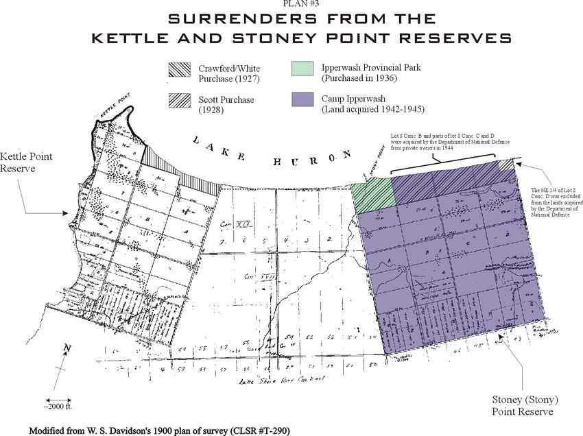
Within a decade of the separation the beachfront on the Kettle Point Reserve was surrendered and
sold. The 83 acres of land sold to Crawford and White in 1927 for $7,055 ($85 per acre) became
the subject of lawsuits and a 1993 claim against Canada. While the courts did not find that the
surrender and sale was illegal, the Indian Claims Commission concluded in 1997 that Canada
breached its fiduciary obligation to the First Nation and recommended a settlement of the claim be
negotiated. This has not yet been done.

Similarly, the beachfront at Stony Point was surrendered and sold in 1928. This 377-acre
property was sold for $13,500 ($35 per acre). A claim alleging that the surrender and sale was
invalid was filed against Canada in 1996 and is currently being considered by the Department of
Justice.

The letters patent for beachfront properties sold at Kettle Point and Stony Point both transferred
the foreshore rights to the purchasers. The issue of whether or not the foreshore was part of the
Kettle and Stony Reserves was unclear to the Department of Indian Affairs and neither the Huron
Tract Treaty nor the original survey of the reserves is clear on the status of the shoreline.

Ipperwash Provincial Park was created by the Province of Ontario in 1932 on land that had been
surrendered from the front of Stony Point Reserve in 1928. As early as 1937 the Chief and
Council notified park authorities that there was a burial ground in the park and asked them to
protect the site. The Department of Indian Affairs also asked that the site be protected. No
action seems to have been taken and many years later, in the 1950s, human remains were located
in the park. The remains were apparently given to an archaeologist but have since been lost. In
the 1990s two independent anthropologists examined photographs of the remains. One
concluded the burial was likely an Ojibwa child of about 11 years of age interred some time in
           th          th
the late 19 or early 20 century, suggesting that this was a Kettle and Stony Point ancestor.
(The other scholar concurred in the age of the individual and posited a burial position consistent
with an Aboriginal burial but did not speculate on the date of the burial).

In 1942, in the middle of World War II, the Department of National Defence (DND) sought the
Stony Point Reserve for use as a training camp. DND contacted Indian Affairs and began
investigating the site in February 1942. Indian Affairs approached the Band encouraging them to
surrender the reserve less than two months later. The Kettle and Stony Point people did not want
to sell their reserve and rejected the surrender by an overwhelming majority.

DND was determined to obtain the property and the Indian Agent saw it as an opportunity to
consolidate the two groups onto a single reserve and remove non-band members. Consequently,
as the surrender did not pass, DND appropriated the reserve using its authority under the War
Measures Act. They renamed the reserve Camp Ipperwash.

The people residing at Stony Point were forced to move to the Kettle Point Reserve where they
were allotted small locations. Band members who were displaced were compensated for
improvements, such as cultivated land and out buildings, and had their houses moved. They did
not receive compensation for unimproved land. DND had authority to expend no more that
$50,000 in acquiring the Stony Point Reserve. After deducting the cost of moving expenses and
the appraised value of buildings they had only $36,000 to pay for approximately 2,273 acres of
land, which amounts to only $15 per acre.

Joan Holmes & Associates Inc.                   5                   Draft Printed June 25, 2004
By July 1942 the Stony Point residents had been relocated to Kettle Point. Squeezing another 16 families onto the limited land at Kettle Point exacerbated tension within the community. When soldiers from Stony Point returned at the end of the war they were shocked to find their community destroyed and relocated to Kettle Point. It was returning soldiers who first raised the alarm about damage to the cemetery enclosed within DND’s Camp Ipperwash. The Indian Agent stated that the military had promised to respect and protect the cemetery when they appropriated the reserve. Both Department of Indian Affairs and an official from National Health and Welfare took the matter seriously. At length a fence was erected around the cemetery. People originally from Stony Point resumed burying members in the old cemetery in 1990. Kettle and Stony Point residents believe that additional burials are scattered throughout the old Stony Point Reserve, particularly in the sand hills. At Kettle Point burials exist close to the waterfront in the unsurrendered portion of the Reserve. Shortly after the end of the Second World War, DND indicated in writing that they were willing to return the Stony Point Reserve and lease back any areas still required. However, this proposal was soon withdrawn when the military resolved to keep the camp for training cadets. Attempts to return the camp surfaced without success over the ensuing years with the Minister of Indian Affairs warning in 1972 that the community was becoming impatient to have their land back and failure to return the camp could lead to civil disobedience. Efforts to arrive at a settlement in the 1970s and 1980s were not successful. In part, the lack of resolution was because of internal disagreement within the Kettle and Stony Point First Nation as to the future of the returned reserve and the relative interest of members in the Stony Point Reserve and the proceeds of a settlement. It was during the 1970s that the Stony Point people asserted that they were and always had been a separate and distinct group. By the 1990s the people had become increasingly impatient with the lack of resolution. Besides launching lawsuits and claims regarding the 1927 and 1928 surrenders and the appropriation of Camp Ipperwash, some Stony Point descendants occupied Camp Ipperwash in 1993 and then moved into the park in September 1995. These actions were not supported by the entire community and increased the tensions. One of the protesters, Dudley George, was shot and killed when the O.P.P. marched on the protestors on the night of September 6, 1995. Joan Holmes & Associates Inc. 6 Draft Printed June 25, 2004
PLAN #1 HURON TRACT PURCHASE

Joan Holmes & Associates Inc.     7          Draft Printed June 25, 2004
PLAN #2 LOCATION OF RESERVES SET ASIDE UNDER TREATY

Joan Holmes & Associates Inc.   8         Draft Printed June 25, 2004
PLAN #3 SURRENDERS FROM THE
                    KETTLE AND STONEY POINT RESERVES

Joan Holmes & Associates Inc.     9           Draft Printed June 25, 2004
BACKGROUND HISTORY OF KETTLE AND STONY POINT
British Indian Policy
Following the conquest of New France, the British created policies for taking control of their
North American colonies. One of their main concerns was their relationship with the First
Nations who were suspicious of British intentions and trustworthiness because of the many
fraudulent land deals and encroachments on their territory. British Indian agents repeatedly
assured their Algonquian and Iroquoian allies3 that the King would protect their land from
encroachment.
In 1763, King George III made the protection of Aboriginal land an official Crown policy when
he issued a Royal Proclamation that has become known as the Indian Charter of Rights.4 First
Nation land rights in Canada flow directly from the Royal Proclamation of 1763. According to
the Proclamation, only the Crown could purchase land from a nation or tribe and no land could
be settled until the Crown made a proper purchase. The Royal Proclamation established a
territory beyond the settled colonies where land settlement was forbidden and access by whites
controlled. Furthermore, the Crown would protect land that had been reserved or set aside for
Indians within the settled colonies against intrusion by non-Aboriginal settlers.
The British made these rules because they believed that fair and open negotiations over
Aboriginal land would help establish and keep peaceful relations with the Indian nations living
under their protection. An Indian Department was established and given the responsibility of
managing Indian affairs on a consistent and uniform basis. Through time the principles laid
down in the Royal Proclamation were refined and expanded to guide the Indian Department,
especially regarding its responsibility for entering into lawful land cession treaties. The
overriding principle established by British Indian policy was that the Indian nations were to be
treated with honour and justice.
The ancestors of the Kettle Point and Stony Point people were residing in the “Indian Country”
as defined in the Royal Proclamation.5 They had enjoyed a treaty relationship with the British
since the 1760s and had been receiving annual presents from the British as a symbol of their
alliance and friendship. The British recognized them as the legitimate owners of the Aboriginal
title in the region around the River St. Clair and the southeast region of Lake Huron when they
th
approached them to make a land cession treaty in the early 19 century.
3 Algonquian-speaking groups around the Great Lakes region included the Ojibwa (Chippewa),
Mississauga, Ottawa (Odawa), and Potawatomi.
4 See Royal Proclamation of October 7, 1763. The Papers of Sir William Johnson, Vol. X, Prepared
for publication by the Division of Archives and History (Albany: The University of the State of New
York), pp. 977-985.
5 Helen Hornbeck Tanner, ed., Atlas of Great Lakes Indian History (Norman and London: University
of Oklahoma Press, 1987), Maps 13 and 20. The Chippewa and Potawatomi ancestors lived within
the following geopolitical areas: Indian country (1763-1774); Quebec (1774-1783); Quebec (1783-
1791); Upper Canada (1791-1849); Canada (1850-1867) and Ontario (from 1867). Some of the
Pottawatomi ancestors were living in American territory from 1783 until they migrated to the British
side.
Joan Holmes & Associates Inc. 10 Draft Printed June 25, 2004The Huron Tract Treaty
After the War of 1812 the Crown wanted to obtain land around Lake St. Clair and Lake Huron to
allow loyal non-Native settlers to populate the area. They were concerned that the old French
settlements could not be trusted to support the British in further struggles against the Americans.
Thus, the ancestors of the Kettle Point and Stony Point people and related Ojibwa (Chippewa)
were asked to cede their land for non-Native settlement. This land cession treaty was negotiated
over a nine-year period from 1818 to 1827 and became known as the Huron Tract purchase.
In 1818, Sir Peregrine Maitland, newly appointed Lieutenant Governor of Upper Canada,
resolved to obtain the land north of the Thames River for the settlement of “loyal subjects in an
area where loyalty had been tested during the war and was often found wanting.”6 It was
Maitland’s initial intention to acquire five different tracts of land including about 712,000 acres
along the southeast shore of Lake Huron and the River St. Clair.7 Maitland considered the land
around the Sable River, where the Stony Point Reserve was later located, as being particularly
desirable.8 The Surveyor General of Upper Canada marked the required areas on a plan.9
The plan was sent to William Claus, Deputy Superintendent General of Indian Affairs, who
instructed Superintendent John Askin to identify the Chippewa “who have claims to that part of
the Country.”10 Although he knew that it was practically impossible to obtain accurate
information, Claus instructed Askin to provide an account of the number of Chippewa men,
women and children in that district.11 Askin responded to Claus’ instructions by sending
messengers to the Chippewa at Chenail Ecarte, River St. Clair, River Aux Sauble and the
Thames to come to Amherstburg for their annual presents. He intended to ask their chiefs and
principal men, who he believed represented the “greatest part of the proprietors of those Lands,”
upon what terms they would dispose of the land indicated on the sketch.12
Less than a week later Askin met in council with the 24 Chippewa chiefs and leaders in the
presence of Lieutenant Colonel Evans, the Commander at Amherstburg, and interpreter Jean
Baptiste Cadot. The Chippewas were from Chenail Ecarte, the St. Clair River, Aux Sauble
6 R. J. Surtees, Indian Land Surrenders in Ontario, 1763-1867 (INAC: Ottawa, February 1984), pp.
79-84.
7 “References to certain letters written in Pencil on the Plan of the Province to which this Paper is
annexed…,” September 17, 1818. NAC RG 10 Vol. 35 pp. 20526-20527.
8 George Hillier, Office of Lt. Governor, York, to Col. Claus, Deputy Superintendent General of
Indian Affairs, Fort George, September 18, 1818. NAC RG 10 Vol. 35 pp. 20528-9. Hillier stated,
“The line enclosed with a pencil mark between the point north of the Sable River and the angle to the
north of Clergy Reserve behind Woolwich appears to the Lt. Governor to be particularly
desirable….” That location is shown on a sketch appended to Provisional Agreement, March 30,
1819. NAC MG 19 F1 Vol. 11 p.107.
9 “References to certain letters written in Pencil on the Plan of the Province to which this Paper is
annexed…”, September 17, 1818. NAC RG 10 Vol. 35 pp. 20526-7.
10 W. Claus, Deputy Superintendent General of Indian Affairs, Fort George, to John Askin, Indian
Affairs Superintendent, Amherstburg, September 22, 1818. NAC RG 10 Vol. 35 pp. 20531-20532.
11 Claus to Askin, September 22, 1818. NAC RG 10 Vol. 35 pp. 20531-20532.
12 Askin to Claus, October 10, 1818. NAC RG 10 Vol. 35 p. 20527.
Joan Holmes & Associates Inc. 11 Draft Printed June 25, 2004River, Thames River and Big Bears Creek.13 The “Chiefs and Leaders” are listed in Appendix
B. Judging by the dodems or totems beside their names the men were from caribou (reindeer),
beaver, otter, and a fish clan perhaps catfish, sturgeon or pike.
Askin told the chiefs and headmen that the Lieutenant Governor wished to purchase all of their
land north of the Thames River including the River Aux Sauble and showed them the sketch. He
then asked them to propose terms upon which they would “dispose” of the land. After
deliberations, Chief Chawne replied for the assembled chiefs asking for specific reserves that
they wanted to keep, specifying the amount of land might be increased if the reserve proved to be
too small. They also asked for compensation in money and clothing, as well as the services of a
blacksmith and agricultural instructor. The minutes of the council recorded their request:
… Their Answer after mature deliberation was as follows-
Father We Chippewas have always been obedient children and never
refused anything our Great Father has required of us, We are therefore
willing to sell our Lands, but we wish to make the following reserves viz
1st Four Miles square at some distance below the Rapids of the river St.
Clair. [Sarnia]
2d One Mile in front by four deep bordering on the said River and
adjoining to the Shawanoe Reserve. [Moore Township or Lower
Reserve]
3d Two miles at Kettle Point Lake Huron. [Kettle Point]
4th Two miles Square at the River au Sable. [Stony Point]
5th Two miles square at Bears Creek also a Reserve for Tomago14 and
his Band up the Thames which he will point out when he arrives.
And we trust that the reserves now made by us will be augmented at the
time the purchase is finally concluded, should our Great Fathers
Representatives see that they are insufficient for the whole of our nation
now living on this side of the waters to plant corn and hunt, so that we
may not be poor and miserable like our Brethren on the American side,
who have sold all their Lands and have not made sufficient Reserves for
their men, women & children to plant corn.
Father You will inform our Great Fathers representative that it [sic]our
wish he himself set the valuation on the Tract required, but that the
Payment is to be made annually for 50 years, half in hard money & half
in cloathing [sic].
The payment for our Lands is to be seperate [sic] & distinct from the
presents our Great Father the King gives us yearly for our loyalty & past
13 th
“Minutes of a Council held at Amherstburg the 16 Oct 1818…,”October 16, 1818. NAC MG 19 F1
Vol. 11 pp. 95-96 Reel C-1480.
14 Tomago was identified as a Bear Creek Chief living eight miles west of Lower Munsey. He fought
with Tecumseh and signed Surrender #21. He used the Beaver totem. See Greg Curnoe,
Deeds/Nations (London: Occasional Publications of the London Chapter, Ontario Archaeological
Society, No. 4, 1996), p. 141.
Joan Holmes & Associates Inc. 12 Draft Printed June 25, 2004services but out of our yearly payments to our Nation is to be furnished
with a Blacksmith & Husbandman to be stationed near the reserves, the
former to mind our axes & Traps and repair our Guns; the latter to
instruct us in the art of Husbandry.15
The reservations appear to have been selected based on areas that particular groups were already
using, including Kettle Point and River Aux Sauble (Stony Point). The chiefs were negotiating
to give up a huge tract of land and must have carefully considered the specific areas they wished
to retain ensuring that they held on to the most precious and significant locations. Although
Chief Tomago was not present, those attending knew what area should be reserved for him and
his band and made sure that their needs were addressed.
Askin informed Claus of their terms.16 The Lieutenant Governor was not prepared to respond to
their proposal but did declare that while “no reservation of any Tract will be acceded to on which
there are white settlers” he would “readily meet their wishes by admitting their occupancy of
such reasonable tracts of land as they may require for their own purposes.”17
Askin planned to call the chiefs and headmen together a second time in the late winter of 1819.18
By this time the Government had decided to purchase all of the land north of the Thames River
in two agreements: the Longwoods Tract along the north shore of the Thames and the more
northerly Huron Tract, where the St. Clair, Kettle and Stony Point people were located.19 To
accommodate the two separate land cession treaties, Askin first met with one group of chiefs in
early March 1819 and made a provisional agreement for the cession of the Longwoods Tract
reserving out a tract near the headwaters of Bear Creek and another reserve on the Thames.20
15 “Minutes of a Council held at Amherstburg the 16th Oct 1818…”, October 16, 1818. NAC MG 19 F1
Vol. 11 pp. 95-96 Reel C-1480.
16 Askin to Claus, October 22, 1818. NAC RG 10 Vol. 35 p. 20585.
17 Claus to Askin, November 19, 1818. NAC RG 10 Vol. 35 pp. 20607-20608. The Lt. Governor
indicated that the reservation proposed at Bear Creek would not be allowed if it interfered with
continuous settlement between Shawanoe [Sombra] Township and London Township. The reserve at
Bear Creek was indicated on the map as Chenail Ecarte. Chief Kitchimawquam and his band were
living at that location. See Askin to Claus, February 17, 1819. NAC RG 10 Vol. 36 p. 20688. This
is likely Kitchemughqua (Big Bear) a descendant of the original Ke cha makqua of Big Bear Creek,
settled at Chenail Ecarte, who signed numerous treaties with the beaver totem. He was murdered in
1803. See Curnoe, p. 48.
18 Askin to Claus, February 19, 1819; Askin to Claus, March 3, 1819. Both on NAC MG 19 F1 Vol. 11
pp. 143-145 and 195-196 Reel C-1480; and Askin to Claus, February 17, 1819. NAC RG 10 Vol. 36
p. 20688.
19 Robert J. Surtees, “Land Cessions, 1763-1830,” in Edward S. Rogers and Donald B. Smith, eds.,
Aboriginal Ontario: Historical Perspectives on the First Nations (Toronto: Dundurn, 1994), p. 119.
20 Canada, Indian Treaties and Surrenders, Vol. I (Ottawa: Queen’s Printer, 1891), Provisional
Agreement #21, March 9, 1819, pp. 48-51. Handwritten copy with totems: NAC MG 19 F1 Vol. 11
Reel C-1480 pp. 135-137, 151. Jean Baptiste Cadot (Cadotte) was the interpreter at the Longwoods
Agreement. A plan showing both the location of the Longwoods Tract (“coloured yellow in
original”) and Huron Tract (marked A and F) and location of reserves (marked “red”) is appended to
printed document. This Provisional Agreement modified in a second provisional agreement #280 ½,
May 9, 1820 and was finally confirmed by #25, July 8, 1822.
Joan Holmes & Associates Inc. 13 Draft Printed June 25, 2004Superintendent Askin remarked that in order get the provisional agreement for the Longwoods
Tract cession he had to agree to mark the Bear Creek Reserve for Chief Ketchimanquan and his
Band on the sketch map. Askin was not sure if he apportioned the amount of the compensation
correctly but assumed that “as the whole of the land required by the Crown belongs to the River
St. Clair, Kettle Point, River au Sable, & River Thames Chippewas, a just dividend will be set
forth when the deed of Conveyance is executed.”21 Askin did not name the people of Chenail
Ecarte in this list.22 He clearly recognized the various groups he was dealing with as separate
bands associated with different locations for which they required reserves but seemed to imply
that they had a collective a claim to the land being ceded by the Longwoods and Huron Tract
cessions.
Several weeks later, on March 30, Askin met with 18 Chippewa chiefs and entered into a
provisional agreement for the cession of the Huron Tract.23 Of the 18 chiefs who signed the
1819 agreement, ten had been at the 1818 council; they were from the caribou (reindeer), beaver,
fish (catfish?) and crane clans and have been identified in secondary sources as belonging to
Sarnia, Chenail Ecarte and Bear Creek.24
The area ceded had increased dramatically to encompass about 2,756,040 acres, which included
the 712,000 acres the Chippewa had discussed in 1818. The description of the ceded area did not
deal precisely with the status of the foreshore25 as it used phrases such as “along the shore of
Lake Huron” and “along the waters edge” and “down the [St. Clair] River.”26
The chiefs asked for the same locations that they had described at the council meeting in October
1818, which were enumerated in the provisional agreement as follows:
• “Four miles square at some distance below the Rapids of the River St. Clair” [Sarnia or
Upper Reserve];
• “one mile in front by four miles deep bordering on the said River St. Clair and adjoining to
the Shawanoe [Sombra] Township” [Moore or Lower Reserve];
• “Two miles Square at the River au Sable which empties into Lake Huron” [Stony Point]; and
• “Two miles at Kettle Point Lake Huron. [Kettle Point]”
21 Askin to Claus, March 12, 1819. NAC RG 10 Vol. 36 p. 20716. The total amount of compensation
for the two tracts was anticipated to be £1975. Of that £1375 was for the Huron Tract consisting of
approximately 2,756,000 acres and £600 for the Longwoods tract consisting of 577,790 acres. See
Askin to Claus, April 1, 1819. NAC RG 10 Vol. 36 pp. 20743-20744.
22 Askin did mention the chiefs of Chenail Ecarte as signing either the Longwoods or Huron Tract
treaty in a subsequent letter. Askin to Claus, April 1, 1819. NAC RG 10 Vol. 36 pp. 20743-20744.
23 Articles of Provisional Agreement, March 30, 1819. NAC MG 19 F1 Vol. 11 pp. 185-190 Reel C-
1480. A sketch map is appended to this document showing the location of the Huron Tract,
Longwoods Tract and location of reserves.
24 See chart in Appendix B for a comparison of chiefs participating in the 1818 and 1819 meetings.
25 Webster’s Third New International Dictionary defines the foreshore as “the part of a seashore
between the low-water line usu. at the seaward margin of a low-tide terrace and the upper limit of
wave wash at high tide usu. marked by a beach scarp or berm” or as “a strip of land margining a
body of water.”
26 Articles of Provisional Agreement, March 30, 1819. NAC MG 19 F1 Vol. 11 pp. 185-190 Reel C-
1480. The sketch map does not clarify the status of the foreshore.
Joan Holmes & Associates Inc. 14 Draft Printed June 25, 2004A perpetual annuity of £1,375, half in goods and half in cash, was to be paid as compensation.27
Due to objections over making the proposed cash payment, the provisional agreement for the
Huron Tract cession was not sanctioned by the Imperial Government.28 It was not until March
1825 that Deputy Superintendent General Claus was again instructed to treat with the Chippewa
Nation for the land, thought to contain about 2,756,000 acres.29 One Indian Affairs official
suggested that they should try to get the chiefs to agree to one reserve in the back country,
however, as is outlined below, the reserves originally selected were again requested.30
In 1820 there were said to be about 225 Chippewas at River St. Clair, 171 at Chenail Ecarte, and
12 at River Aux Sauble, a total of 408 people.31 The Chippewa at Chenail Ecarte and St. Clair
were alarmed that trespassers were removing timber, stone and hay from their lands without
permission or compensation.32 In 1823, the Chippewa at River Aux Sauble specifically
complained that trespassers removed salt and stone from their land at Salt Spring.33 Their
complaints were relayed to the head of the Indian Department but there is no record that the
depredations ceased.
Indian Superintendent James Givens made a new provisional agreement with 20 Chippewa chiefs
at Amherstburg on April 26, 1825.34 At the meeting O Saw a wip spoke on behalf of the chiefs
and Wa wa nosh was said to be the principal chief.35 The provisional agreement became known
as Surrender 27 ½. At least ten of the chiefs who had attended the 1818 council and 11 of the
chiefs who signed the 1819 provisional agreement signed Treaty 27 ½.36 The same clans were
represented. The named chiefs were ceding the land on behalf of themselves and the Chippewa
27 Articles of Provisional Agreement, March 30, 1819. NAC MG 19 F1 Vol. 11 pp. 185-190 Reel C-
1480. A sketch map is appended to this document showing the location of the Huron Tract,
Longwoods Tract and location of reserves. The annuity of £1,375 was equivalent to about $5,500.
The signatories of the Longwoods Tract were supposed to receive £600.
28 Surtees, Indian Land Surrenders …, pp. 79-85. See also Government House Memo, March 25, 1825.
NAC RG 10 Vol. 43 pp. 22764-22767. The Longwoods Tract provisional Agreement was not
sanctioned either.
29 Hillier to Claus, March 21, 1825. NAC RG 10 Vol. 43 p. 22761.
30 George Ironside, Indian Affairs Superintendent, Amherstburg, to Claus, April 6, 1825. NAC RG 10
Vol. 43 p. 22772.
31 George Ironside, Superintendent of Indian Affairs, Amherstburg, “Return of the Number of Men,
Women & Children of the Chippewa Nation inhabiting & claiming the large Tract ceded”, May 16,
1820. NAC RG 10 Vol. 37 pp. 21193 - 21194 Reel C-11011. Note the estimate of the number of
Chippewas ceding the tract was 440.
32 Ironside to Colonel Claus, Deputy Superintendent General of Indian Affairs, August 8, 1820. NAC
RG 10 Vol. 38 pp. 21536-21538 Reel C-11012.
33 Ironside to Claus, May 14, 1823. NAC RG 10 Vol. 41 pp. 22240-22241.
34 Surtees claims that the delay in making the second Huron Tract Agreement was due to Lieutenant
Governor Maitland who did not feel there was any urgency to the transaction. After John Galt’s
proposed scheme to form the Canada Company, the acquisition of the Huron Tract became more
important, as a million acres of Indian Land was to be given to the company. Surtees, "Land
Cessions, 1763-1830," p. 118.
35 Minutes of Council, April 26, 1825. NAC RG 10 Vol. 43 pp. 22773-22776 Reel C-11013.
36 See chart in Appendix B for a comparison of chiefs participating in the 1818, 1819 and 1825
meetings.
Joan Holmes & Associates Inc. 15 Draft Printed June 25, 2004Nation “inhabiting and claiming the territory.”37 The 1825 provisional agreement made no
reference to the 1819 agreement.38
The ceded land was said to contain 2,756,960 acres. The location of the reservations remained
the same but their combined acreage was increased by 14 acres to comprise a total of 23,054
acres. The amount of annuity was reduced from £1,375 to £1,100 for the 440 Indians said to
inhabit and claim the ceded tract.39 It was stipulated that if the Indian population declined by
half “by deaths or removals,” then the amount of the annuity would be reduced by half and
would continue to be reduced based on other further population declines. There was no
corresponding clause in case of an increase in population. The Imperial Government approved
the provisional agreement.40
A surveyor laid out the Kettle and Stoney Point Reserves in 182641 as “generally described” in
the 1825 provisional agreement.42 At that time Surveyor Burwell found people living at Kettle
Point and drew a sketch of Chief Chemokomon’s house and war pole, shown below.43
37 No. 27 ½ April 26, 1825. Canada. Indian Treaties and Surrenders, Vol. I (Ottawa: Brown
Chamberlain, Printer to the Queen’s Most Excellent Majesty, 1891), p. 66.
38 The 1819 agreement and the amount of annuity to be offered were referred to in the order to seek a
cession. Order from Government House, March 25, 1825. NAC RG 10 Vol. 43, p. 22764.
39 No. 27 ½ April 26, 1825. Canada. Indian Treaties and Surrenders, Vol. I, pp. 65-67.
40 H. C. Darling, Military Secretary, Quebec, to Sir John Johnson, Superintendent General of Indian
Affairs, December 20, 1825. NAC RG 10 Vol. 17 pp. 13159-13160 Reel C-11,003.
41 Plan of the Huron Tract, March 2, 1827. Canada. Indian Treaties and Surrenders, Vol. I. Ottawa:
Brown Chamberlain, Printer to the Queen’s Most Excellent Majesty, 1891 p. [90]. The parcels are
shown on a plan of survey dated March 2, 1827, showing the area ceded by surrender No. 29.
42 D. C. Scott, Deputy Superintendent General of Indian Affairs, to J. E. Armstrong, Petrolea, Ontario,
September 17, 1930. NAC RG 10 Vol. 7540 File 29,029-2-1A.
43 Ontario Surveyor General’s Office, Crown Land Records, Field Books, Transcribed Volume 20, p.
536. Chief Chemokomon is likely Chief Ashkebahgahneguod identified by Gulewitsch as a Chief at
Kettle Point also known as John Big Knife, Chemokomon, Oshawawanoo or Shahwawanoo. Victor
A. Gulewitsch, The Chippewas of Kettle & Stony Point: A Brief history. Chippewas of Kettle and
Stony Pont Historical Claims Research Office, 1995, pp. 20-1. His direct ancestors have the family
names Shawnoo and Shawkence.
Joan Holmes & Associates Inc. 16 Draft Printed June 25, 2004Two years later Treaty 27 ½ was confirmed by Treaty No. 29, the Huron Tract Treaty.44
Superintendent George Ironside took the confirming cession at Amherstburg from 18 chiefs.45
Of the 18 who signed the 1827 treaty, nine had attended the 1818 council, 10 had signed the
1819 provisional agreement and 16 had signed Treaty 27 ½. Seven individuals had been present
at all four of the land transaction council meetings.
The description of the boundaries of the ceded tract and the four reserved areas were consistent
with the 1825 provisional agreement. The reserves had been surveyed and were now known to
comprise a total of 17,951 acres. This was about 26 per cent less land than had been stated in the
1825 provisional agreement.46 The described locations were “expressly reserv[ed] to the said
Nation of Indians and their posterity at all times hereafter, for their own exclusive use and
enjoyment.” The acreage of each reserve was as follows:
Mouth of the River aux Sable on Lake Huron – 2,650 acres
Kettle Point on Lake Huron47 – 2,446 acres
Upper Reserve or Sarnia on the St. Clair River – 10,280 acres
Lower Reserve or Moore Township on the St. Clair River - 2,575 acres
The land ceded comprised 2,182,049 acres. For the first time the ceded land was said to include
the “woods and underwoods, ways, waters, watercourses, [and] improvements.”48 Thus, the
Chippewas represented by 18 chiefs ceded over 2 million acres of land to the Crown. They
retained less than one per cent for their own exclusive use and occupation. Those reserves had
been described and insisted upon throughout the nine years of negotiations, suggesting that the
ceding groups considered them the most significant and necessary of all the areas they
customarily used. In 1930 the Deputy Superintendent General of Indian Affairs opined that the
Kettle and Stoney Point Reserves as surveyed by Burwell were “excepted by specific
description” from the ceded tract when it was confirmed by the Huron Tract Treaty in July 1827.
He also concluded that the reserve extended to the shores of Lake Huron.49
In addition to the reserved land they were granted a perpetual annuity. The annuity of £1,100
was to be divided on an equal basis between the 440 Chippewa claiming the land. This
amounted to a payment of £2.10s for every man, woman and child.
Finally. after nine years of repeated discussions, the Chippewas of Chenail Ecarte (Walpole),
River St. Clair (Sarnia), River Aux Sauble (Stony Point and Kettle Point) ceded an area at first
thought to contain about 712,000 acres but actually covering more than three times that amount
of land. When they first met in 1818 the Chiefs asked for specific reserve locations which could
be enlarged if found too small to support the people; in the final treaty they were left with less
44 Surrender #29, Huron Tract Treaty, July 10, 1827. Canada. Indian Treaties and Surrenders, Vol. I,
pp. 71-75. The full text of the surrender can be found in Appendix C.
45 See chart in Appendix B for a comparison of chiefs participating in the 1818, 1819, 1825 and 1827
meetings.
46 No. 27 ½ April 26, 1825. Canada. Indian Treaties and Surrenders, Vol. I, pp. 65-67.
47 The description of the River aux Sable and Kettle Point Reserves indicated the “water’s edge” as the
place of beginning. See the following section on the survey of the reserves for more detail.
48 Surrender #29, Huron Tract Treaty, July 10, 1827. Canada. Indian Treaties and Surrenders, Vol. I, p.
74.
49 D. C. Scott, Deputy Superintendent General of Indian Affairs, to J. E. Armstrong, Petrolea, Ontario,
September 17, 1930. NAC RG 10 Vol. 7540 File 29,029-2-1A.
Joan Holmes & Associates Inc. 17 Draft Printed June 25, 2004than one percent of their traditional territory with no provision for expansion. Furthermore, after
surveying the tract, prior to the confirmation treaty in 1827, the acreage of the reserves had been
reduced to 75 per cent of the acreage quoted in the 1825 provisional agreement. At the opening
of the negotiations in 1818 they asked the King’s representative to set the appropriate
compensation, trusting in his good will and sense of justice. The initial offer of £1,375 ($5,500)
was reduced to £1,100 ($4,400) and the provision of a blacksmith and an agricultural instructor
was omitted.
Early 19th Century Indian Department Administration
Shortly after the treaty was signed, the Chippewas at Chenail Ecarte and St. Clair River were
pressured to remove to the River Aux Sauble Reserve, which they refused to do.50 However,
there was at least one suggestion that the land at River Aux Sauble be exchanged for an
additional tract at Kettle Point or some other place in the vicinity on the grounds that the land at
River Aux Sauble was judged unsuitable for agriculture.51
The Walpole Island chiefs wanted to separate from the Sarnia and River Aux Sauble people. In
1836 the chiefs decided to split the annuity and reserves between the Walpole and St. Clair
(Sarnia and River Aux Sauble) Bands. Walpole Island took $1,400 of the annuity and the Lower
St. Clair Reserve (Moore Township) and the Sarnia Band kept $3,000 of the annuity and the
reserves at Kettle Point, River Aux Sauble (Stony Point) and the Upper St. Clair Reserve.52 The
division was not officially made and the Walpole and Sarnia portions of the Band were
administered by two different Indian Superintendents who distributing the treaty annuity money
based on the proportion of the Band residing at Walpole Island and those at Sarnia and Aux
Sauble.53
Despite its unsanctioned division, Sarnia and Walpole Island dealt separately and independently
with land in the 1840s. These actions were not sanctioned by the Crown because the reserves
were considered communal lands in which all of the groups held an undivided interest.54
50 J. Givins, Chief Superintendent, Department of Indian Affairs, April 12, 1830; Ironside to Givins,
May 5, 1830; Ironside to Givins, June 2, 1830; Ironside to Givins, June 7, 1830. NAC RG 10 Vol.
46; Wm. Jones, Indian Agent, Baldoon, to Henry Jones, June 24, 1830, NAC RG 10 Vol. 5 pp. 2478-
2480 Reel C-10997.
51 William Jones, Assistant Superintendent, Indian Department, to Givins, March 6, 1836. NAC RG 10
Vol. 10028; Jones to Givins, June 19, 1837. AO Private Manuscripts Section, Letterbooks
Collection, Letterbook of William Jones, Indian Agent, Baldoon, Upper Canada, 1831-1839 Micro
Reel MS 296; and G. Chewitt, sketch, 1837 [circa, undated]. NAC RG 10 Vol. 128 p. 72243.
52 Canada, Journal of the Legislative Assembly, Sessional Papers, 21 Victoriae Appendix (No. 21) A.
1858. “Report of the Special Commissioners appointed on the 8th of September, 1856, to Investigate
Indian Affairs in Canada,” p. 58. Hereinafter cited as the Pennefather Report. William Jones to
Givins, March 6, 1836. NAC RG 10 Vol. 10028; and Givins to Jones, April 4, 1836. NAC RG 10
Vol. 501..
53 William Jones to J. B. Clench, Indian Superintendent, Delaware, January 19, 1845. NAC RG 10
Vol. 438.
54 R. W. Rawson, Chief Secretary, to S. P. Jarvis, Chief Superintendent, Upper Canada, October 14,
1843. NAC RG 10 Vol. 148 No. 642 Reel C-11,493; Rawson to Jarvis, October 21, 1843. NAC RG
10 Vol. 137 No. 643.
Joan Holmes & Associates Inc. 18 Draft Printed June 25, 2004Another agreement was apparently arranged to divide the annuities between the two groups in
1848 but no official division of the accounts was concluded until the 1860s.55
Under the Indian Act a band is defined as a body of Indians who hold a reserve in common or
who share in annuity money56 so the division of land and annuities affected the legal status of the
communities as separate bands. When they were treated as one large band each group was
constrained in how they could deal with the reserves that they used and resided upon.
Early 19th Century Communities
In the late 1830s most of the Aboriginal inhabitants of the Huron Tract were still leading a fairly
traditional way of life. Those of the Upper Reserve adjacent to the Township of Sarnia hunted
on the unsettled parts of Sarnia and Moore Townships. The Walpole Island and Chenail Ecarte
people hunted and used land in the unsettled parts of Sombra, Doan and the adjacent islands.
Those of the Aux Sable used the unsettled parts of the Canada Company Tract. They maintained
settled areas for planting and sugaring. According to an 1839 Indian Department report:
In winter most of these people resort to favourable situations for hunting
and for making sugar, but return in the spring in time for planting.
There is a missionary and school master, attached to the Upper Indian
Reserve on the St. Clair both belong to the Wesleyan Methodist Society
– Mr. Jones57 is resident superintendent.58
By the mid-1840s numerous families had settled on the Upper Reserve in the Township of
Sarnia. This reserve of over 10,000 acres had attracted a Wesleyan Methodist missionary who
was busy attempting to convert the Chippewa and Pottawatomi to Christianity. According to one
church scholar, Sarnia had been earmarked for those who wanted to be Christianized and
Walpole for the traditionalists. Walpole was populated by many American Indians who had
55 Statement of Account, 1849 [circa], NAC RG 10 Vol. 443; J. B. Clench, Superintendent of Indian
Affairs, to T. E. Campbell, Superintendent General, Department of Indian Affairs, March 27, 1849.
NAC RG 10 Vol. 176 No. 3701-3800 Reel C-11,506; J. B. Clench to Colonel Robert Bruce,
Superintendent General, Department of Indian Affairs, April 23, 1850; and W. Spragge, Deputy
Superintendent General of Indian Affairs to Froome Talfourd, Visiting Superintendent, Indian
Department, Sarnia, March 8, 1862. NAC RG 10 Vol. 452. During the period the Indian
Superintendent actually kept a separate account of the two groups’ share of funds and maintained
separate distribution lists.
56 The 1876 Indian Act, S.C. 1876, cap. 18, s. 3. While the circumstances of the Huron Tract people
predated the Indian Act those basic administrative principles were being followed by the Indian
Department prior to being formally codified in the legislation.
57 William Jones held the rank of Assistant Superintendent at the Indian Department station on the St.
Clair. He had served with the Indian Department since around 1831. His interpreter was Joseph St.
Germain who had served since around 1812. See list of employees, Macauley Report, NAC RG 10
Vol. 117 p. 168,809.
58 NAC RG 10 Vol. 117 p. 168762-168763. For entire 1839 Macauley Report, see pp. 168711-168867.
Joan Holmes & Associates Inc. 19 Draft Printed June 25, 2004sought refuge in Canada; some were “companions of Tecumseh and one was a grandson of
Pontiac.”59
Missionaries made a concerted effort to convert the Chippewa. Wawanosh of Sarnia first
accepted Methodism in 183560 and later welcomed the Anglican Church.61 The Indian
Superintendent stationed at Sarnia also had responsibility for the people settled at River Aux
Sauble, Kettle Point, and Moore Township Lower Reserve. He noted that individual farms and
advances in agriculture were largely confined to the Upper Reserve.
While written records state that the reserve at River Aux Sauble had been occupied since about
1842, it is clear that the area was used and valued by the Chippewa long before that time as they
had selected it for a reserve. Surveyor Burwell noted the chief’s house at Kettle Point in 1826
and a visible gravesite near the mouth of the au Sauble River.62 In 1838 there was said to be a
population of 27.63 By 1842 there were about 60 acres under cultivation. One log house had
been built and about 25 people were living in traditional wigwams.64 By 1845 there were 27
people settled at Kettle Point, 49 at River au Sauble under Chief Quaykegoin and 35 people
under Chief Wapagase for a total of 111 people at Kettle and Stony Point.65 Chief Wapagase had
been a chief at River au Sauble since at least 1839.66 Chief Quaykegoin has signed the 1819,
1825 and 1827 treaties.67
59 John Webster Grant, Moon of Wintertime: Missionaries and the Indians of Canada in Encounter
since 1534 (Toronto: University of Toronto Press, 1984), p. 80. Elizabeth Graham also states that
the portion of the St. Clair people who did not want to be “civilized” went to Walpole Island.
60 Elizabeth Graham, Medicine Man to Missionary: Missionaries as Agents of Change among the
Indians of Southern Ontario, 1784-1867 (Toronto: Peter Martin Associates Limited, 1975), p. 38
(citing Christian Guardian March 18, 1835: 62). “It was rumoured that Wawanosh had tried to get
[interpreter George] Henry out so he could appoint his son David as interpreter. In 1841 Wawanosh
charged [agent] Keating … with habitual intoxication and encouraging the Indians to drink,
swearing, proselytizing for the church of England, etc. soon after this, charges were brought against
Wawanosh by some of the Indians, supported by the agent, who accused him of mismanagement and
improper conduct. The Methodist missionary, [William] Scott, supported Wawanosh, but in 1843
Wawanosh was dismissed from his position, and Mishebishee was appointed in his place,” p. 38.
Mishebishee was succeeded by Joshua Wawanosh and David Wawanosh was appointed
schoolteacher, p. 39.
61 Grant, p. 88. Graham states Edward Wilson claimed that Wawanosh and 12 to 14 families joined the
Church of England, p. 39.
62 Ontario Surveyor General’s Office, Crown Land Records, Field Books, Transcribed Volume 20, p.
536. The grave site is discussed further below.
63 William Jones, "Numerical Return of Resident Indians, who to receive presents for the year 1838, at
the Upper St. Clair Reserve”, August 31, 1838. NAC RG 10 Vol. 127.
64 Province of Canada, Journal of the Legislative Assembly, Sessional Papers, Appendix EEE, “Report
of the Affairs of the Indians in Canada, Laid Before the Legislative Assembly, 20th March 1845”
Section II No. 4. Hereinafter cited as the Bagot Report. Sections I and II, unpaginated.
65 A Chief Wa pa gace signed the 1825 provisional treaty and died in 1827. The family name became
Johnston. This Chief Wapagase is likely a direct descendant. See Curnoe p. 153 and 156.
66 William Jones to J. B. Clench, January 19, 1845. NAC RG 10 Vol. 438. Superintendent Jones notes
Chief Wapagase as the Chief at au Sable in 1839. See Curnoe p. 153 and 156. See Appendix D for a
population chart.
67 See Appendix B for a list of chiefs who signed the treaties.
Joan Holmes & Associates Inc. 20 Draft Printed June 25, 2004You can also read