Kepler Track, Fiordland National Park - Wilderness Magazine
←
→
Page content transcription
If your browser does not render page correctly, please read the page content below
Kepler Track, Fiordland National Park
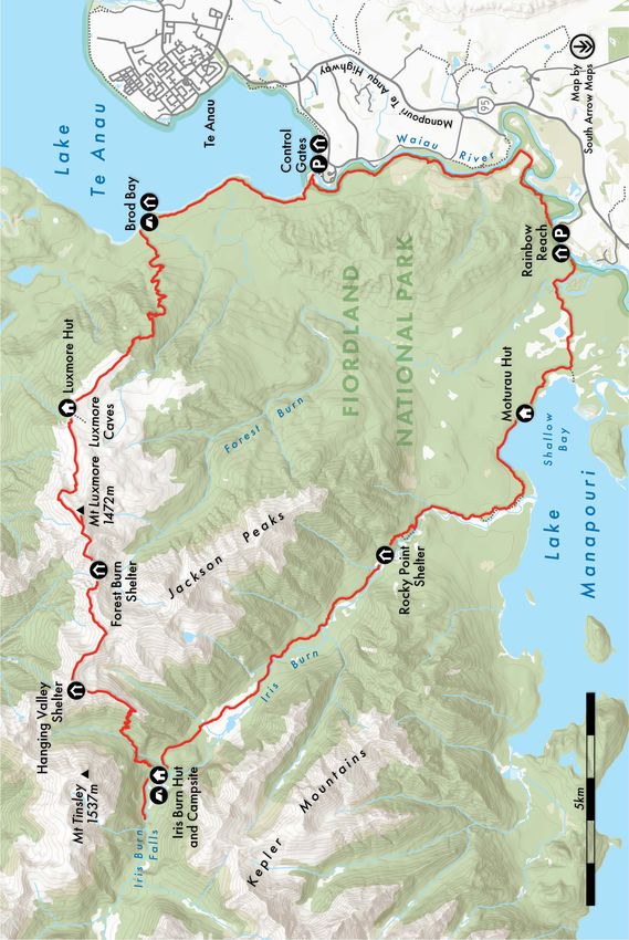
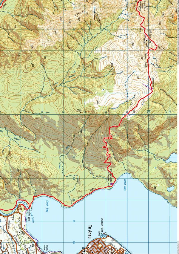
From the Control Gates at the outlet of Lake Te Anau, the Kepler Track skirts the shoreline of Dock Bay,
passing through beech trees sporting a colourful array of lichens, mosses and other small plants. Easy travel
leads to the campsite and shelter at Brod Bay. The serious climbing begins beyond, through the forest and
onto the slopes of Mt Luxmore.
Zigzags help ease the gradient, but it’s still a steady climb, passing limestone bluffs at one point before finally
emerging onto the tawny tussock tops. Luxmore Hut is just 30 minutes away, perched on poles with a
commanding view over the South Fiord, and the Murchison Mountains. If the weather remains good, it’s worth
scrambling up Mt Luxmore (1472m), or visiting the nearby caves (take a torch).
The track then sidles around the side of Mt Luxmore, with a short side-trip to the summit, so you get a second
crack at the highest point on the route. Beyond, the ridge narrows before reaching Forest Burn Shelter, one of
two shelters on this tops section.
The sense of going deeper into the mountains strengthens as you head west, with the sinuous South Fiord
probing into the heart of Fiordland’s central mountains. The track alternates between sidling around knolls,
and following the ridge directly, and Hanging Valley Shelter makes a convenient place for a break before the
descent into the Iris Burn.
The steepest descent of the track leads down into the Iris Burn, which drains the heart of the Kepler
Mountains. Iris Burn Hut occupies a clearing in the beech forest, with a view of Mt Tinsley. A 20-minute walk
leads to Iris Burn Falls.
From the hut, the track follows the true left of the Iris Burn down a glacier-carved valley. At one point, there’s a
view of a landslide that occurred in 1986, leaving a huge scar known as Big Slip. The track follows the burn all
the way to the shores of Lake Manapouri, which it skirts to reach Moturau Hut. The hut has a pleasant outlook
over the myriad islands of Lake Manapouri, some shaped like beehives. On a calm day, it’s a place of
tranquillity and birdsong.
An enjoyable side-trip from the main track leads to the six-bunk Shallow Bay Hut, one of the park’s older and
smaller huts, near the mouth of the Waiau River. This river links Lake Te Anau with Lake Manapouri, and the
remainder of the Kepler Track more or less follows its upstream course back to the Control Gates.
On the way, the track passes a sizeable wetland, where a boardwalk and viewing platform offer views of the
Jackson Peaks and the extensive stands of forest on the surrounding flats. After crossing the Forest Burn, the
track reaches a large footbridge spanning the Waiau. This offers the option of finishing the track at Rainbow
Reach. Trampers wanting to complete the whole Kepler circuit continue on for another 2-3 hours on a well-
benched, easy section of track that follows the true right of the river.
Wild File
Access Kepler Track car park at the Control Gates, Te Anau
Grade Moderate-difficult
Time 3-4 days. Car park to Luxmore Hut, 5-6.5hr; To Iris Burn Hut, 5-6hr; To Moturau Hut, 5-6hr; To car, 4-5hr
Distance 58km
Total ascent 2492
Accommodation Luxmore Hut (54 bunks), Iris Burn Hut (50 bunks), Moturau Hut (40 bunks
Map CD07
Elevation Profile
© Wilderness Magazine, www.wildernessmag.co.nz
Disclaimer: While every effort has been made to map this route correctly, Wilderness does not accept responsibility for any errors. Users should plan their routes and gather as much
information as possible before departing. The GPX file associated with this route has been drawn using Memory-Map software, version 6. Use descretion when following the route,
especially when no track is marked on the map. The GPX file in these cases are a ‘best guess’ of the route only. Users should use a combination of GPS, visual observations, maps
and compass to find the best possible route. Memory Map shows purple tracks and hut icons as verified routes and huts. Red or blue routes are those drawn by Wilderness.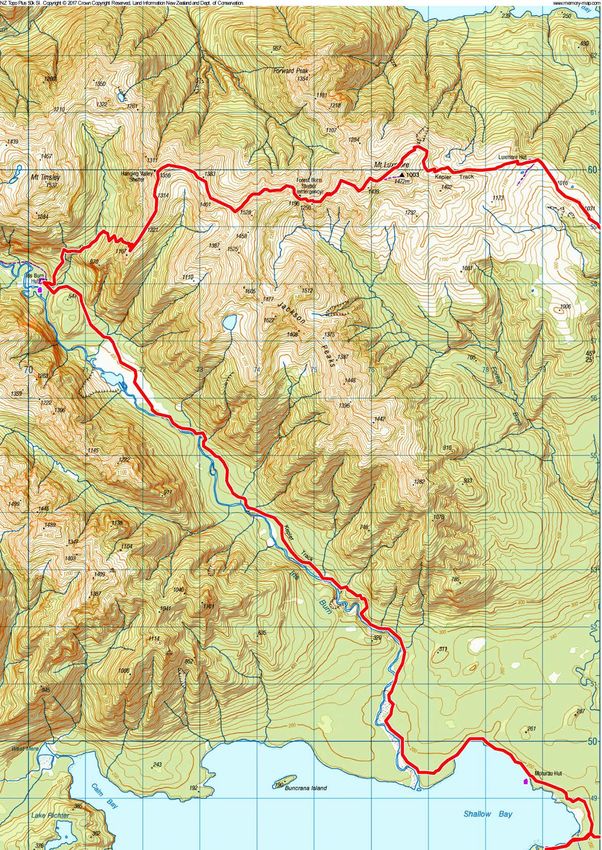
Kepler Track, Fiordland National Park. Map 1

                                 © Wilderness Magazine, www.wildernessmag.co.nz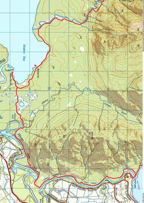
Kepler Track, Fiordland National Park. Map 2

                              © Wilderness Magazine, www.wildernessmag.co.nz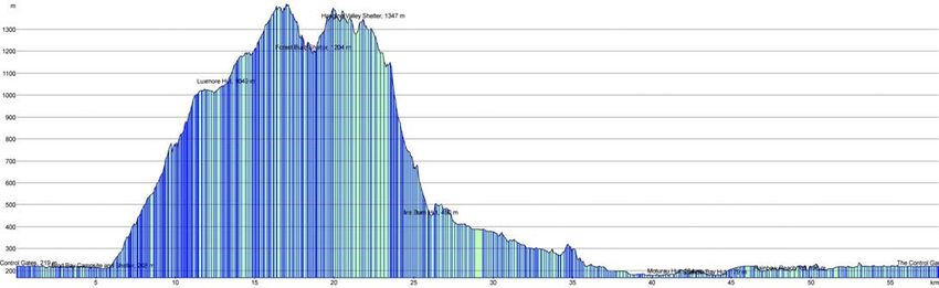
Kepler Track, Fiordland National Park. Map 3

                              © Wilderness Magazine, www.wildernessmag.co.nz
You can also read