Cleveland Lakefront Freight Rail Bypass
←
→
Page content transcription
If your browser does not render page correctly, please read the page content below
Cleveland Lakefront
             Freight Rail Bypass
           Concept proposal and analysis

                By Kenneth J. Prendergast
                   for the BLUE Project
of EcoCity Cleveland and the Cleveland Waterfront Coalition

                        July 2003

    Funding for the BLUE Project has been provided by
              The George Gund Foundation
        and the Raymond John Wean Foundation
BLUE Project/Lakefront Rail Bypass Study/page 2
Table of Contents
(note that all maps and figures mentioned in the text are collected at the end of this document)
Executive Summary ........................................................ Available online
Section One - Background and Overview
Introduction..................................................................................................4
Case examples..............................................................................................4
Overview......................................................................................................5
History..........................................................................................................6
Conrail acquisition .......................................................................................9
Section Two - Alternatives analysis of Lakefront Bypass
Overview....................................................................................................11
Alternative Route 1 - CSX ‘Short Line’ ....................................................11
Alternative Route 2 - NS/CSX Fort Wayne Line ......................................14
Alternative Route 3 - NS Fort Wayne Line/
NS Columbus-Bellevue Line ...............................................15
Alternative Route 4 - NS Cloggsville Bypass/NS NKP Line/
NS Randall Secondary ........................................................17
Section Three - Projected capital investments for developing the
proposed Lakefront Bypass
Presentation structure and analysis methodology ......................................22
Option 1 .....................................................................................................22
Option 2 .....................................................................................................23
CP190/Rockport Yard-west .......................................................................24
CP491/Rockport Yard-east ........................................................................25
Linndale-Southwest ...................................................................................26
Downtown-South .......................................................................................28
East 37th Street area...................................................................................30
North Broadway.........................................................................................33
CP117 and vicinity.....................................................................................35
Total infrastructure costs of Lakefront Bypass..........................................37BLUE Project/Lakefront Rail Bypass Study/page 3
Section Four - Projected impacts from the proposed Lakefront Bypass
Overview....................................................................................................38
Community impacts ...................................................................................39
Lakefront impacts .....................................................................39
Commuter rail ...........................................................................39
Neighborhood impacts ..............................................................40
Impacts on Norfolk Southern.....................................................................42
Operating savings......................................................................42
Impacts on new business opportunities.....................................43
Impacts on proposed new infrastructure ...................................44
Additional opportunities to NS .................................................44
Potential drawbacks to NS ........................................................44
NS financial contribution..........................................................45
Other potential impacts ..............................................................................45
STB’s “Conrail Agreement” .....................................................45
Improved Cuyahoga River access.............................................45
Intercity passenger rail..............................................................46
Section Five - Conclusion
Conclusion .................................................................................................47
Potential resources for funding the Lakefront Bypass...............................47
Closing comments......................................................................................49
Resources
Listed alphabetically ..................................................................................50
Maps and charts
All maps and charts are collected at the end and arranged by page numbers specified in text.BLUE Project/Lakefront Rail Bypass Study/page 4
SECTION ONE
Background and Overview
Introduction
Cleveland city officials and their consultants are conducting detailed studies of the Lake Erie
waterfront. The scope of their studies is to evaluate way to promote recreational and
development opportunities along the lakefront to make it more of a community resource that
improves the region’s quality of life and economy. Part of the study’s scope is to evaluate ways
to improve access to the lakefront. One way is to make man-made barriers (highways, railways,
etc.) less of an obstacle for people wanting to reach the water’s edge. Another way is to improve
transportation (road, transit, biking, pedestrian, etc.) to the North Coast.
It is important to note that highways and railways can be both an obstacle to and a resource for
reaching Cleveland’s lakefront. This report, conducted at the request of EcoCity Cleveland and
the Cleveland Waterfront Coalition, will focus on the railways, and present a concept proposal
for dealing with both the obstacle and accessibility issues via a single project -- the Cleveland
Lakefront Freight Rail Bypass (or, more simply, the Lakefront Bypass).
Case examples
Cleveland city officials and their consultants often point to cold-weather cities like Chicago and
Toronto as examples of what might be possible with Cleveland’s lakefront. Both Chicago and
Toronto are also case examples of how rail freight traffic has been relocated away from those
cities’ downtown lakefronts, and how other forms of rail traffic, namely commuter rail and/or
rail transit were expanded or built new as part of their lakefront improvement and accessibility
plans.
Anyone who has visited Chicago and Toronto in recent decades would likely agree that those
cities have thriving lakefronts that are attractive not only to new downtown residential
construction, but to recreational opportunities and tourism. Those land uses also provide a more
environmentally benign edge than industrial and port uses for those cities’ downtown
waterfronts.
Starting in the 1890s, with the Columbian Exposition, Chicago officials made an important
decision to promote their downtown as a lakefront a place for people to enjoy recreation and
people watching. Railroad operations on the lakefront, particularly those of the Illinois Central
on the south side of downtown, were put into trenches below street level and restricted only to
passenger rail service. There are no through-downtown railways in Chicago, save for two local
operation tracks at Chicago Union Station, which is a mile inland. All through freight train
service is restricted to tracks even further inland. “Belt railroads,” such as the Indiana Harbor
Belt Railroad, were built around the city of Chicago so freight traffic could bypass the urban
core. Today, these belt railroads are 2-5 tracks wide, and see more than a hundred freight trains a
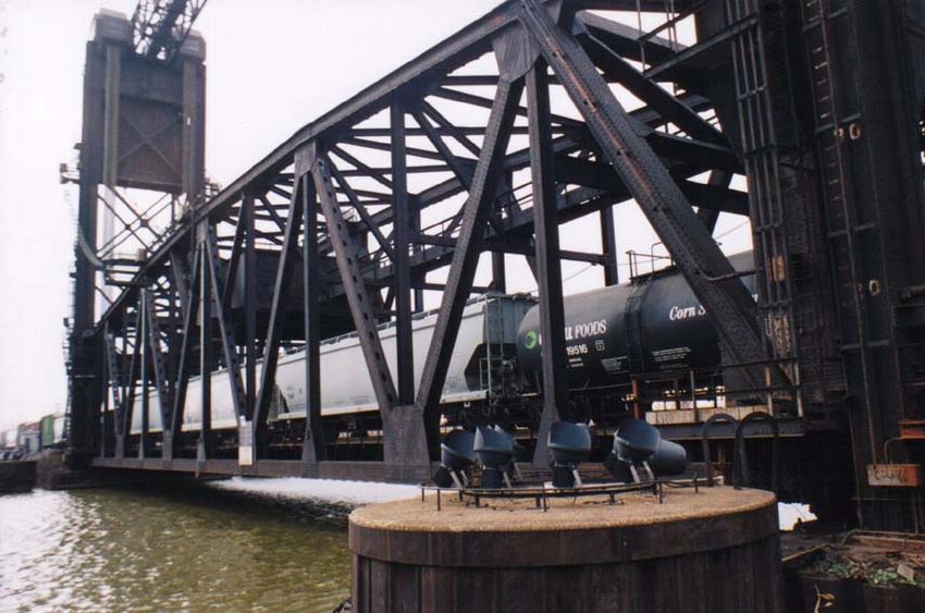
day. Near-downtown freight railroad yards that were still active in the 1960s have since beenBLUE Project/Lakefront Rail Bypass Study/page 5 redeveloped with housing, offices and retail starting in the 1980s. Dearborn Park is a notable example of this transformation. Toronto is even more of an applicable example for Cleveland, given its history. As recently as the 1960s, Toronto was not known as a thriving, cosmopolitan city. It underwent a transformation in rapid order, as part of a regional planning effort. Much of that effort placed an emphasis on redeveloping Toronto’s downtown lakefront, which was characterized by a string of weed-choked rail yards, associated underutilized railroad and port facilities, plus a decaying Toronto Union Station. With the construction of a citywide subway system, and the addition of commuter trains on several freight lines, Toronto’s lakefront Union Station gained new life and was restored to its former grandeur. The freight rail yards were redeveloped with a number of notable structures, including the CN Tower, Metro Convention Center, Skydome sports complex and hotel, plus new neighborhoods. A Harbourfront Line light-rail trolley was built in the 1990s from Union Station to the lakefront to serve the new housing, recreational and tourist sites. Although some local freight rail services remain to service lakefront industrial and port customers (mostly east of the Don River), east-west trunk line freight rail services, provided by Canadian National and Canadian Pacific, bypass the downtown lakefront on a belt line around the northern edges of the core city. Overview Cleveland has a lot in common with Chicago’s and Toronto’s earliest stages of developing their lakefronts, particularly in terms of those cities’ decisions on what lakefront rail traffic should be kept and expanded, and what rail traffic should be relocated. But, to more effectively evaluate where Cleveland is today in terms of its lakefront railway users, an inventory of Cleveland’s lakefront railroad infrastructure and operations is in order. There are three distinct classifications of rail operations on Cleveland’s lakefront, most of which operate in the downtown area -- freight, intercity passenger and light-rail transit. Freight Rail: Most dominant of these is rail freight service, provided primarily by Norfolk Southern Corp., which operates nearly 50 daily freight trains on rights of way it owns along the lakefront, handling about 60 million gross tons of traffic per year. In better economic times in the late 1990s, NS dispatched approximately 55-60 trains along its lakefront tracks, which are its primary east-west artery between Chicago, St. Louis, Toledo, Detroit and Pittsburgh, Philadelphia, plus New Jersey/New York City. These trains cross the Cuyahoga River at its mouth, and on a two-track drawbridge which is typically left in the “down” position owing to the frequency of rail traffic. This bridge, while left down, is only 5-10 feet above the river’s waterline under most climatological conditions. The drawbridge is staffed 24 hours a day by NS employees who are in constant radio and telephone contact with NS train & engine employees, dispatchers and others.
BLUE Project/Lakefront Rail Bypass Study/page 6

According to NS operating personnel, between 7-13 daily freight trains must operate via the
lakefront tracks and over the Cuyahoga River drawbridge to serve the Port of Cleveland,
customers on Whiskey Island (ore docks, Cargill Salt) and other industrial customers in the
immediate area.

Another freight rail carrier, CSX Transportation Inc., owns a lightly-used right of way along the
lakefront east of downtown. Under Conrail ownership prior to 1999, this right of way was used
by dozens of daily freight trains, but those were rerouted to the south and east sides of the city of
Cleveland along a Conrail right of way CSX acquired in 1999.

CSX currently operates as many as one freight train a day on its lakefront tracks, and has
trackage rights (access by long-term contract) over NS tracks along the lakefront west of
downtown. According to the Ohio Rail Development Commission, CSX’s agreement with NS,
per federal Surface Transportation Board approval in 1998, allows CSX to operate up to several
dozen freight trains per day via the lakefront. This agreement allows the lakefront CSX route to
serve as a “relief valve” or sorts, in case of emergencies or traffic congestion on its primary right
of way on the south/east sides of the city. CSX’s primary right of way sees up to 50 daily freight
trains as it is the company’s primary artery between Cincinnati, St. Louis, Chicago and Buffalo,
Boston, plus New York City.

Light-rail transit: Light-rail service on the Waterfront Line, owned and operated by the Greater
Cleveland Regional Transit Authority, is another significant rail presence on the lakefront.
However, its right of way and related facilities are restricted to the immediate downtown area.
While the Waterfront Line has low ridership, it represents a significant, physical presence owing
to its double track, overhead electrical power lines and support poles (called a catenary), 112
daily trains, three substantial station facilities and a winding, elevated section of trackage just
east of the Cuyahoga River’s mouth to traverse the NS main line and head south into the Flats
District.

Intercity passenger rail: This is the third classification of rail service currently operating on
Cleveland’s lakefront, and is also the least extensive. This service is provided by Amtrak, the
national passenger railroad, and comprised of four daily trains between Chicago and the East
Coast which have contractual operating rights to travel on NS and CSX rights of way. All four
Amtrak trains stop at the carrier’s Cleveland Lakefront Station, at 200 Memorial Shoreway,
across the highway from Cleveland Browns Stadium. Amtrak’s station facility and parking lot is
located on city-owned land, for which Amtrak is not obligated to make lease payments.
However, Amtrak does own land at the former East 26th Street rail yard, just south of South
Marginal Road, where the circus train is parked when the circus is in town.

History

There have been numerous efforts to detour freight and passenger rail traffic away from the
lakefront, particularly in the vicinity of downtown. However, most of those efforts weren’t
intended to make the lakefront more suitable for recreational and development purposes. Instead,
BLUE Project/Lakefront Rail Bypass Study/page 7

they were sought to cope with rail and river traffic congestion in and near the drawbridge near
the mouth of the Cuyahoga River. The earliest efforts dates back to the early 20th century.

Prior to 1910, all east-west rail traffic on the busiest trunk line railway through Cleveland -- the
New York Central Railroad’s (NYC, former Lake Shore & Michigan Southern) -- crossed the
Cuyahoga River on a single-track lift bridge near the mouth of the river. That bridge was roughly
at the same location as Norfolk Southern’s present-day drawbridge at the north end of the Flats
District. By 1910, NYC tracks in the vicinity of the lift bridge became horribly congested with
train traffic, including roughly 100 NYC freight and passenger trains each day, according to
railroad employee operating timetables from that era.

It should be noted that, prior to 1930, the city’s Union Depot passenger station was located on
the lakefront, between West 3rd and West 9th streets. Several dozen NYC daily passenger trains
served this station each day, as did those of the Pennsylvania Railroad and the Cleveland,
Cincinnati, Chicago & St. Louis (Big Four Route) Railroad. Additionally, the Pennsylvania
Railroad (PRR) served the Cleveland & Pittsburgh Railway ore docks on Whiskey Island (the
C&P was absorbed into the PRR about 1900), with its trains using the NYC lift bridge to reach
its main line that curved southeast toward Pittsburgh on the east side of downtown Cleveland.

First Lakefront traffic reroute--1911: Faced with this rail traffic congestion, New York
Central built a railway bypass around the southern and eastern sides of the city of Cleveland.
Called the Cleveland Short Line Railroad (or, simply, the Short Line), this lakefront bypass
opened in 1911. This mostly double-tracked route had no grade crossings with any streets and
even passed underneath the Broadway-Harvard neighborhood through a series of single-track
tunnels. When rail freight traffic declined in the 1960s-80s, some sections of the second main
track were removed (mainly on the East Side). Today, most of this route is owned and used by
CSX Transportation Inc. for its Midwest-East Coast freight mainline (see “Fifth Lakefront
Traffic Reroute--1999”). The extreme westernmost portion of the Short Line is owned and used
by Norfolk Southern Corp. for its Rockport Yard.

Second Lakefront traffic reroute--1930: Another detour of rail traffic off the lakefront began
in 1930. This time, it was intercity rail passenger service that found a new route through the city.
New York Central’s long-distance passenger trains were put on new, passenger-only tracks using
a new high bridge across the Cuyahoga River valley to reach the new Cleveland Union Terminal
(Tower City Center today) on Public Square. The station also served passenger trains from four
other railroads, with more than 70 scheduled arrivals and departures each day when the new
station opened.

However, some of NYC’s luxury express trains, like the 20th Century Limited, Commodore
Vanderbilt, and Ohio State Limited continued to operate via the lakefront. After rail passenger
service declined and Cleveland Union Terminal was closed to long-distance passenger trains
(owing to its high cost), the coming of Amtrak in the 1970s put all passenger trains back on the
downtown Cleveland lakefront.

Third Lakefront traffic reroute--1983: Unlike the first two efforts, this detouring of rail traffic
off the lakefront did not involve the construction of new rights of way. Conrail rebuilt the former
BLUE Project/Lakefront Rail Bypass Study/page 8

Pennsylvanian Railroad (PRR) route from Cleveland to Alliance, Ohio into a modern, high-
volume railway, boosting train speeds from 40 mph (and often less) to 60 mph. With this
reconstruction project, some Chicago-East Coast freight traffic was rerouted off another Conrail
route via Canton and Mansfield to Cleveland and Toledo to rationalize Conrail’s infrastructure.
However, Conrail didn’t want all of this freight traffic to travel via Cleveland’s lakefront, due to
congestion and other operational issues. Thus, it rebuilt a track connection (called the Harvard
Connection) in the vicinity of the Harvard-Broadway neighborhood so that freight trains could
use the Short Line to bypass downtown Cleveland altogether. The Harvard Connection was
heavily used until the Conrail acquisition in 1999, and is used today by only two trains a day
(freight transfers between Motor Yard in Macedonia and Rockport Yard in Cleveland). It
remains intact and could again be used as a lakefront bypass for NS if CSX (the new owner of
the Short Line -- see below) is willing to consent to it.

Fourth Lakefront traffic reroute--1999: The next major detour of rail traffic away from the
Cleveland-area lakefront occurred with the 1999 acquisition of Conrail Corp. by CSX
Transportation and Norfolk Southern Corp. (for more detail on the Conrail acquisition and how it
has opened up an opportunity for the proposed Lakefront Bypass, see the section “Conrail
acquisition”).

Through the Cudell and Edgewater neighborhoods of Cleveland, and the West Shore suburbs of
Lakewood, Rocky River, Bay Village, Avon Lake, Lorain and other adjacent communities,
Norfolk Southern proposed tripling its freight train traffic. This added traffic was to operate over
NS’s former Nickel Plate Railroad trackage, from Buffalo, NY to its major rail yard near
Bellevue, Ohio in Huron County. Significant community opposition to the expected increase in
rail traffic was raised.

Instead, NS agreed to build a $27 million, double-tracked connection (called the “Cloggsville
Connection”) just south of Cleveland’s Ohio City neighborhood. This connection, along with
another new track connection near Vermilion in Erie County, allowed NS to detour up to a dozen
through freight trains daily, away from the populous West Shore suburbs, to a less populated,
more industrialized route via Linndale and Berea. This detour route is envisioned as the western
half of the Lakefront Bypass, proposed in this report.

Fifth Lakefront traffic reroute--1999: A more significant reroute of freight train traffic, away
from the lakefront, also occurred as a result of the Conrail acquisition. As noted earlier, CSX
acquired much of the former New York Central Cleveland Short Line Railroad around the
southern and eastern sides of the city of Cleveland. CSX also acquired from Conrail the former
New York Central line southwest of Greater Cleveland to Greenwich in Huron County, where
CSX links up with its existing Chicago-Washington D.C. mainline. Furthermore, CSX acquired
from Conrail the former New York Central line northeast from Greater Cleveland to New York
City and Boston.

To stitch together these Conrail routes with its own rights of way, CSX invested more than $200
million of its own capital to build new track connections, add long stretches of second track,
widen overpasses, install gates/flashers at road-rail grade crossings, build sound barriers/add
soundproofing to homes, and upgrade signaling systems. The end result was a new double-track
BLUE Project/Lakefront Rail Bypass Study/page 9

rail corridor from the Midwest to the East Coast along alignments which previously were either
underutilized or not connected to each other.

CSX’s investment meant the removal of up to 30 freight trains a day from Cleveland’s lakefront,
to join with the 20 former Conrail freights already routed via the Short Line. This routing is next
to Interstate 480 near the Cleveland-Parma border, on a high bridge over the Cuyahoga Valley in
suburban Brooklyn Heights/Cuyahoga Heights, beneath the Broadway-Harvard neighborhood,
next to the RTA Red Line through University Circle and East Cleveland, and then parallel to
East 131st Street into the Collinwood Yard.

Of all the efforts to relocate rail traffic off the Cleveland lakefront, this has proven to be the most
significant. Ironically, however, this permanent reroute had little or nothing to do with lakefront
issues. Instead, CSX simply wanted its own self-determined route through the city for its east-
west freight traffic, and the Short Line provided that path.

Conrail acquisition

If it wasn’t for the 1999 Conrail acquisition by Norfolk Southern Corp. and CSX Transportation
Inc., it is quite likely that there would be no reasonable opportunity for detouring all but 7-13
daily freights away from the lakefront.

First, some historical background is in order. Conrail was set up in 1976 by the federal
government to take over and rebuild six bankrupt Northeast railroads, including Penn-Central
(by far, the largest of the six). Penn-Central in 1968 had acquired the former New York Central
and Pennsylvania railroads. After an infusion of $5.8 billion in federal funding to rebuild tracks
and rail yards, buy new locomotives and rail cars, plus the abandonment of redundant rail lines
and other assets, Conrail became a profitable railroad company starting in the 1980s. The federal
government sold its ownership interest in Conrail in a public stock offering in 1987. Finally,
Conrail was bought up by its competitors CSX and NS and its routes and other assets were
divided up roughly evenly between them. Final approval of the acquisition by the federal
regulatory agency having oversight of railroads, the Surface Transportation Board, was given in
1998. The actual operational changeover took place in June 1999.

Changes in rail traffic, resulting from the Conrail split, became a controversial, public issue in
Greater Cleveland in the late 1990s. While NS proposed tripling its rail freight traffic through the
West Shore suburbs, CSX planned to quadruple rail freight traffic along the Short Line through
the southern and eastern portions of the city of Cleveland and adjacent suburbs. The community
and environmental impacts of these dramatic changes in rail traffic patterns were taken into
account by a final agreement approved by the federal Surface Transportation Board (STB).
Given the wholesale, system-wide changes resulting from the Conrail split, serious operational
problems resulted at NS and CSX. However, these problems were resolved in less than a year.

In terms of the scope of this report, the net effect of the Conrail acquisition was that as many as
30 freight trains were rerouted off the downtown lakefront onto CSX’s newly acquired Short
Line, south and east of the city of Cleveland. Equally as important, especially in terms of the
BLUE Project/Lakefront Rail Bypass Study/page 10

proposed Lakefront Bypass, as outlined in this report, NS freight traffic in the West Shore
suburbs was redirected to a more inland route.

A consulting firm, Stone Consulting of Warren, Pa., was retained by NS during the Conrail
acquisition process. This firm made two recommendations to NS, both of which have direct
implications to the Lakefront Bypass proposed in this report. However, only one of those
recommendations was adopted by NS -- to construct the Cloggsville Connection (south of
Cleveland’s Ohio City neighborhood) to allow a permanent detour of through freight traffic out
of the West Shore suburbs.

The other recommendation by Stone Consulting was to rebuild a rail corridor and two track
connections on the southeast side of downtown in the North Broadway neighborhood so that
some rail freight traffic could be detoured away from downtown Cleveland’s lakefront. While
the Cloggsville Connection was accepted and implemented by NS, the North Broadway rail
corridor wasn’t. Political pressure and the availability of non-NS funding for roadway
underpasses in Berea appeared to be difference in securing the West Shore bypass. No such
external funding was made available to NS to implement the North Broadway rail corridor.
Thus, the Lakefront Bypass remains unrealized and, therefore, is the subject of this report, as
requested by EcoCity Cleveland and the Cleveland Waterfront Coalition.

NOTE: For a visual presentation on how railroad route ownership and rail traffic patterns have
been affected in Northeast Ohio and in the Greater Cleveland area by the Conrail acquisition,
refer to the maps on Pages 1.8-1.11.
BLUE Project/Lakefront Rail Bypass Study/page 11

                                    SECTION TWO
                        Alternatives analysis of Lakefront Bypass

Overview

Identification of a recommended Cleveland Lakefront Freight Rail Bypass was the result of a
careful consideration of various routing alternatives for rail traffic. Existing active rail rights of
way that were analyzed include only those which are geographically proximate to Greater
Cleveland so as to limit any loss of access to existing rail freight customers. Another factor was
that this report considered only those rail lines that currently intersect with Norfolk Southern’s
existing Chicago-Pittsburgh mainline at two locations -- one somewhere west of Cleveland’s
lakefront and the other east of it. Given these practical limitations, only four route alternatives
are worthy of consideration, and are presented in this section.

This analysis is greatly influenced by and based on the recent genesis of freight rail traffic flows
in Northeast Ohio, affected primarily by the 1999 acquisition of Conrail rights of way by Norfolk
Southern Corp. (NS) and CSX Transportation Inc. (CSX). These property acquisitions and the
locations, alignments, ownership and engineering characteristics of rights of way of other rail
lines were primary factors in the final recommendation of the proposed Lakefront Bypass. Other
factors included the locations of existing and potential rail freight shippers, waterborne shipping
and recreational traffic, residential areas and recreational sites.

The four lakefront bypass alternatives are:

1 -- CSX “Short Line”
2 -- NS/CSX Fort Wayne Line
3 -- NS Fort Wayne Line/NS Columbus-Bellevue line
4 -- NS Cloggsville Bypass/NS NKP Line/NS Randall Secondary

Alternative Route 1 -- CSX “Short Line”

Aside from the recommended Lakefront Bypass, this is the next-best alternative for diverting
most of NS’s freight train traffic away from the Cleveland lakefront. This alternative, if fully
developed to accommodate all of NS’s general and intermodal freight trains that don’t have to
operate via the lakefront, would divert NS traffic away from only 14 miles of its lakefront route.
Thus, this option would have the least impact on existing NS freight operations among the three
alternatives that aren’t recommended by this analysis as effective and practical solutions for
diverting freight train traffic from Cleveland’s lakefront.

Prior to the purchase and “split” of Conrail assets, including rights of way, among NS and CSX,
a significant portion of Conrail freight traffic bypassed Cleveland’s downtown lakefront. The
route used was a portion of the former Cleveland Short Line Railroad (known simply as the
“Short Line), which was owned by Conrail. This right of way roughly parallels Interstate 480
along the Cleveland-Parma border, before turning northeast to cross the Cuyahoga River valley
BLUE Project/Lakefront Rail Bypass Study/page 12 on a high-level viaduct. Mostly double-tracked and equipped with automatic block signals, this flat route featured 50 mph top speeds for up to 20 Conrail freight trains a day. At a location that is adjacent to the Mill Creek waterfalls in the South Broadway neighborhood of Cleveland, a single-track connection (called the Harvard Connection) linked the Short Line to Conrail’s Cleveland Line to Alliance, Ohio and thence to Pittsburgh. Thus, east-west Conrail freight train traffic between the Midwest and the East could bypass downtown Cleveland’s lakefront. However, heavy freight traffic could not easily use this bypass given the steep grades of the Harvard Connection. And, since local topography in the vicinity of the Mill Creek waterfalls prevented widening the right of way to two tracks, there was, and is, a restriction as to how much freight traffic could use this bypass without major reconstruction of the right of way. There is one grade crossing on this route -- with another rail line near the Parma Chevy plant. Here, the CSX Short Line crosses a CSX secondary track with about 4-6 daily trains on it. The CSX Short Line crosses no navigable waterways. It does, however, pass next to several residential areas: the Idlewood Drive neighborhood in Brooklyn, the Ideal Trailer Park on Brookpark Road in Cleveland, and a number of streets near Mill Creek in Cleveland. The Mill Creek Park is the only recreational area next to the CSX Short Line. The acquisition of Conrail by NS and CSX turned ownership of the Short Line over to CSX, which now runs up to 50 freight trains per day over the Short Line. NS runs two freight trains a day, carrying auto parts shipments from Motor Yard, near the Ford plant in Walton Hills, to Rockport Yard (near Hopkins Airport). NS does have trackage rights (a contractual usage agreement), per the federal Surface Transportation Board’s approval of the Conrail acquisition, to use CSX’s Short Line as a temporary, emergency detour route for freight traffic operating via the downtown lakefront. Thus, NS does have a possible “foot in the door” for using CSX’s route for more of its freight traffic. And, since this route alternative is the most geographically proximate of the three alternatives presented herein to NS’s lakefront tracks, it wouldn’t diminish NS’s access to many of its freight customers. Only 17 miles of NS’s lakefront right of way would lose traffic under this alternative -- a preferred circumstance for existing NS customers wanting to enjoy their continued access. There are significant disadvantages to using this route as a lakefront bypass for NS, however. While CSX has added a second main track on some single-tracked sections of the Short Line to accommodate former Conrail freight train traffic between the Midwest and the East Coast, a short section of single track remains through a series of tunnels in the Broadway-Harvard neighborhood. This often causes freight train congestion, as traffic in one direction must wait for frequent opposing rail traffic to clear the single-track section. A major shortcoming of this bypass alternative is that NS doesn’t own the right of way. Wherever possible, freight railroads like to keep their own traffic on their own rights of way. A comparable scenario is if General Motors asked Ford if it could use one of Ford’s busy factories to manufacture its own competing brand of vehicles. To overcome this apparent fatal flaw to this bypass alternative, an expansion of track capacity on CSX’s Short Line to handle diverted NS freight traffic would be needed.
BLUE Project/Lakefront Rail Bypass Study/page 13

A low-impact option is if NS diverted traffic over the CSX Short Line about 20 general freight
trains a day (assuming that 12 NS intermodal freight trains per day continue to operate via the
lakefront and up to eight NS intermodal freight trains are diverted via Canton as discussed under
Alternatives 2 or 3 listed on the next few pages). CSX’s existing freight train congestion
problems associated with its single-track operation through the tunnels beneath the Harvard-
Broadway neighborhood will require significant investment to accept additional traffic in this
area. To overcome this shortcoming, implementation of one of two options would likely be
needed.

One option is to increase CSX’s track capacity on its Short Line by constructing an additional
track through the series of single-track tunnels noted previously, requiring the widening of the
tunnels and/or “day-lighting” them (remove the overhead earth to convert the tunnels to an open-
air right of way). The other option is to build a third main track west of the Harvard Connection
to and through NS’s Rockport Yard to provide enough capacity for NS and CSX. This would
likely require widening CSX’s double-tracked, high-level viaduct over the Cuyahoga Valley and
the widening of CSX’s mainline next to I-480, involving the reconstruction of multiple road
overpasses and underpasses along the rail line. It is likely that only one of these capacity
enhancements would need to be undertaken to handle another 20 trains a day.

But either option would likely incur significant capital costs of at least $100 million per option,
with the net result of accommodating only 10 daily NS general freights via the CSX Short Line
(assuming up to eight more trains are diverted via Canton per Alternatives 2 or 3 at a cost of no
less than $30 million to $50 million). Yet, 12 daily NS intermodal and general freight trains plus
another 7-13 lakefront freight trains that cannot be diverted (or up to 25 total trains) would
continue to operate via the lakefront.

If NS’s 12 daily intermodal and general trains (in addition to the 20 already proposed to be
rerouted via the Short Line plus the eight trains previously suggested for a reroute via Canton)
are all diverted to CSX’s Short Line, significant additional capital costs would have to be
incurred. A second track would have to added to the Harvard Connection, next to the Mill Creek
waterfalls, by removing part of the hillside next to the connection to make room for this new
track. Or, instead, a new double-track “flyover” bridge for NS trains might be built instead of
using the Harvard Connection. This would put NS traffic on the north side of the CSX line so it
could return to NS’s Chicago Line at CP190 (northwest of the CSX mainline). This would
eliminate the need for those NS trains to cross over to the other side of the CSX line at grade and
create a bottleneck. An NS flyover bridge would also potentially provide a more gentle grade and
curvature than the existing Harvard Connection.

It is also likely that CSX’s single-track tunnels beneath the Harvard-Broadway neighborhood
would have to be widened or “day-lighted” to add a second track so CSX traffic congestion can
be alleviated. The CSX high-bridge over the Cuyahoga River would need a totally new viaduct
to accommodate a third main track. Similarly, the CSX Short Line next to I-480 would likely
need to be widened to three tracks to accommodate at least 80 daily CSX/NS freight trains over
this 10.5-mile CSX-owned segment, requiring the reconstruction/widening of nine roadway
underpasses or overpasses. Additional NS track connection improvements at the east end of the
Harvard Connection and at both ends of Rockport Yard would incur additional costs. Projected
BLUE Project/Lakefront Rail Bypass Study/page 14

capital costs for this option could be $250 million to $350 million. Should it still be desirable to
divert eight NS intermodal trains via Canton, at least $30 million to $50 million should be added
to the above costs. But, given a full-scale capacity enhancement of CSX’s Short Line, at nearly
$350 million, this route should be able to handle the added NS intermodal traffic. If desired, a
more detailed analysis will be needed to clarify these significant expenses.

Regardless, those issues make the rerouting of most NS lakefront freight traffic via CSX’s Short
Line very problematic. Use of CSX’s Short Line is therefore not recommended as a Lakefront
Bypass route for NS’s major freight rail traffic through the Greater Cleveland area.

Alternative Route 2 -- NS/CSX Fort Wayne Line

Initially, under Conrail ownership, the Fort Wayne Line was a major route for freight traffic
between Chicago and Pittsburgh, though it became less so starting in the 1980s. Conrail rerouted
much traffic off this route (via Alliance, Canton, Mansfield, Lima and Ft. Wayne, IN) northwest
from Alliance, through Cleveland and Toledo. Today, segments of the Ft. Wayne Line are under
a mixture of ownership by NS (east of Crestline to Alliance), CSX (west of Crestline to Ft.
Wayne) and NS (west of Ft. Wayne to the Chicago area). The Ft. Wayne Line remains lightly
used with less than a dozen freight trains daily on the busiest segment east of Crestline to
Alliance. Many double-tracked segments have since been single-tracked, with more single-
tracking planned.

Per the federal Surface Transportation Board’s approval of Conrail’s acquisition by NS and
CSX, NS gained trackage rights to operate up to eight of its freight trains per day on the CSX-
owned segment west of Crestline to Bucyrus, and six of its trains per day west of Bucyrus to Ft.
Wayne. NS runs about six daily trains over these CSX-owned segments. STB made this
recommendation based on the need to give existing freight customers the same through-route
access they enjoyed under Conrail while providing NS and CSX traffic several connections from
the former Conrail Ft. Wayne Line to the routes they either owned prior to the Conrail
acquisition, or since acquired new from Conrail. The STB also made the recommendation to give
CSX competitive access to Ft. Wayne, whose rail shippers would otherwise have been served
only by Norfolk Southern.

Thus, STB responded to pressure from freight shippers along the Ft. Wayne Line to enact the
shared usage of this route. It is one of the few instances in Ohio, and indeed anywhere in the
nation, where a shared operation exists on such a long railroad right of way (125 miles from
Crestline, OH to Ft. Wayne, IN). This anomaly was made possible by the political pressure
exerted by local shippers, and by the fact that the Ft. Wayne Line was (and is) so lightly used.

Given the length of this potential bypass -- about 405 miles (from Alliance, OH to the Chicago
area) -- there are a limited number of NS freight trains that can be relocated away from
Cleveland’s lakefront to this route without significantly reducing access to NS’s freight shippers
along the more northerly route. However, NS operating employees indicate there are as many as
eight daily intermodal freight trains that might be rerouted out of Cleveland and Toledo to the Ft.
Wayne Line since those trains serve no customers en route between Alliance and the Chicago
BLUE Project/Lakefront Rail Bypass Study/page 15

area. This would still leave about 40 freight trains a day operating via Cleveland’s lakefront, but
it would have some positive impacts, in terms of traffic reductions on a more localized lakefront
bypass within the Greater Cleveland area, such as CSX’s Short Line or on the recommended
Lakefront Bypass that would link a series of disconnected, NS-owned rights of way on the south
side of downtown Cleveland.

The Ft. Wayne Line has hundreds of grade crossings, nearly all of which are with roads, but 20
(in Ohio and Indiana) crossings are with other railroads. It crosses no navigable waterways until
near Chicago, which the diverted trains would have crossed anyway, had they not been diverted.
Also, there are dozens of cities, towns and villages that have residential areas and parks near the
tracks.

Routing more NS trains over the CSX-owned portion of the Ft. Wayne Line between Crestline
and Ft. Wayne would require the renegotiation of the STB-approved trackage rights agreement
between CSX and NS. While this may be possible, a potential glitch exists in NS’s planned
elimination of a second main track between Alliance and Canton, which would significantly
reduce the traffic capacity over this segment, and thereby negatively affect the overall capacity
for all through traffic over the entire Ft. Wayne Line. Already, under Conrail’s previous
ownership, a portion of the Ft. Wayne Line between Massillon and Wadsworth was reduced to
single track. Outside forces would have to persuade NS to abandon its latest single-tracking
plans to ensure that this right of way remains viable as a potential bypass route.

Another problem exists in that the Ft. Wayne Line, on the 125-mile segment between Crestline
and Ft. Wayne, has had its electronic traffic control system removed. Not only did this reduce
capacity of the line, it also reduced maximum freight train speeds from 70 mph to 49 mph. West
of Ft. Wayne, the railway is in good condition, with the signal system left intact. Thus, 60 mph
top speeds for trains are available.

There are, however, no known existing fatal flaws preventing using this route as a Cleveland-
area bypass for up to eight daily NS intermodal freight trains. That assumes an expenditure of
about $40 million to $70 million is invested to restore the passing sidings along the single-
tracked sections of the Ft. Wayne Line, upgrade the existing through tracks and restore the
signaling system where it has been removed. If additional diversions of about 10 trains a day
were operationally possible, this could raise the capital costs of upgrading the Ft. Wayne Line to
$50 million to $90 million. Given these high costs and limited ability of this option to serve as a
serious bypass route, Alternative Route 2 is rejected.

Alternative Route 3 -- NS Fort Wayne Line/NS Columbus-Bellevue line

This option proposes using the eastern portion of Conrail’s former Ft. Wayne Line, which is
more fully described under Alternative Route 2 above. Under this alternative, a portion of freight
rail traffic to/from Pittsburgh could continue west of Alliance (instead of northwest of Alliance
on NS to/from Cleveland) to/from the CSX-owned right of way west of Crestline to/from
Bucyrus, OH in Crawford County. At Bucyrus, NS trains could use an existing track connection
(though requiring improvements) to transfer to/from NS’s Columbus-Bellevue right of way,
BLUE Project/Lakefront Rail Bypass Study/page 16

which recently was double-tracked, to reach NS’s major rail junction in Bellevue, OH in Huron
County. Only 12 miles of this route option would use a non-NS owned right-of-way. This
exception is a CSX-owned segment between Crestline and Bucyrus, over which NS operates
about six trains per day, and has trackage rights to run up to eight trains per day.

At Bellevue, NS traffic rerouted away from Cleveland could use two of its own rights of way for
the continued trek to/from Chicago. The least disruptive of these, from NS customers’ likely
points of view, is to use NS’s former W&LE right of way northwest to Oak Harbor, OH, where
trains could use a recently constructed track connection to rejoin the existing NS mainline out of
Cleveland to/from Toledo and points west and north. This would bypass about 165 miles of NS’s
current mainline via Cleveland.

The other route option from Bellevue is for bypassed freight traffic to use NS’s NKP Line west
of Bellevue via Ft. Wayne to serve Chicago. This would bypass about 405 miles of NS’s existing
mainline via Cleveland, Toledo and other cities, resulting in a loss of access to a significant
number of existing NS customers in those cities.

While such a bypass alternative would actually give NS greater operational flexibility, given the
addition of routing options between Chicago and Pittsburgh, there are some disadvantages to this
alternative. Foremost is the added route mileage just between Alliance and Toledo (140 current,
177 proposed) via slower-speed tracks for the eight daily diverted, time-sensitive intermodal
trains. Approximately $30 million to $50 million would also have to be expended to divert just
eight daily trains. If additional diversions of about 10 more trains per day were operationally
possible, it would likely require capacity-enhancement investments from Oak Harbor to
Bellevue, at NS’s Bellevue interlocking, along the affected portion of NS’s Columbus-Bellevue
route, on CSX’s single-tracked Crestline-Bucyrus segment, and on NS’s single-tracked segment
between Orrville and Massillon. Such improvements could be expected to cost between $100
million to $150 million -- just to divert up to 18 daily freight trains out of Cleveland. Moreover,
external pressure would be needed to encourage NS to not proceed with its near-term plans to
remove the second main track between Canton and Alliance, that would further reduce the
capacity of this route option.

During the debates in the late 1990s surrounding the Conrail acquisition, there were some
suggestions that NS traffic through Cleveland could instead use a regional railroad as a bypass.
Under this suggestion, NS freight traffic would use the Ft. Wayne Line west of Alliance to
Orrville, OH in Wayne County. There, some NS traffic could switch over to a regional railroad
called the Wheeling & Lake Erie (W&LE) for 70 miles between Orrville and NS’s major
junction in Bellevue. But this was rejected due to the expense involved in rebuilding the W&LE
to mainline standards. Current estimates show that upwards of $100 million would be needed to
rebuild the W&LE and upgrade its Orrville connection with NS. It should also be noted that
there is a deep, institutional divide between NS and W&LE on a number of policy and operating
issues that will take a great deal of effort to overcome. Given the costs and limited ability of this
option to serve as a serious bypass route, Alternative Route 3 is rejected.
BLUE Project/Lakefront Rail Bypass Study/page 17

Alternative Route 4 -- NS Cloggsville Bypass/NS NKP Line/NS Randall Secondary

Not only is this route option far superior to the other three Lakefront Bypass alternatives, many
of its features compare favorably with the existing lakefront route. It can accommodate more
traffic for less money than any of the alternatives without degrading service access to existing
Norfolk Southern customers. And it is shorter and flatter than the existing lakefront route.
Indeed, Alternative Route 4 appears to have only two major drawbacks: that it cannot offer the
60 mph top speeds (for freight) of the lakefront route (50 mph would be the top freight speeds for
this bypass); and it lacks all the tracks and connections necessary to be a high-capacity bypass
route. Section Three will detail what is needed to make Alternative Route 4 a whole right of way
by stitching together three different route segments, all owned by NS. Consideration of this
lakefront bypass alternative will include a full, comparative analysis of its physical features with
that of Norfolk Southern’s existing mainline via the lakefront.

Proposed Route: The proposed routing of Alternative Route 4 is described here, from west to
east (see also the map on Page 2.12). Eastbound NS traffic would leave the lakefront route
(called the Chicago Line on Cleveland’s West Side) at Norfolk Southern’s CP190 (a dispatcher
control point that is 190 miles from Buffalo, NY). CP190, located near Hopkins Airport and
beneath the interchange of Interstates 480 and 71, is the western access to NS’s Rockport Yard
and to NS’s Cloggsville Bypass tracks. Alternative Route 4 would use NS’s double-tracked,
eight-mile-long Cloggsville Bypass right of way (with only 10 trains per day on it) eastward and
northeastward to an old railroad location called Cloggsville, near West 25th street, south of
Cleveland’s Ohio City neighborhood. There, Alternative Route 4 would use 2.5 miles of Norfolk
Southern’s double-tracked Nickel Plate Line (with only 16 trains per day on it) that crosses the
Cuyahoga River valley on a high bridge (with an NS-staffed drawbridge above the river) passing
south of downtown Cleveland. At the west end of NS’s East 55th Street Yard, Alternative Route
4 would diverge onto a new, 2,000-foot-long track connection to reach NS’s Randall Secondary.
After traveling on two miles of the Randall Secondary, an eastbound freight using Alternative
Route 4 would rejoin NS’s lakefront route (called the Cleveland Line on Cleveland’s East Side)
at CP117 (a dispatcher control point that is 117 miles from Rochester, PA). Westbound NS
traffic would also follow this same alternative route, but from the opposite direction.

Rationale and potential benefits: There are a number of reasons why Alternative Route 4
makes sense as the Lakefront Bypass, both from a railroad operational perspective and from a
community interest perspective. The community’s interest, as noted in Section One of this report,
include the removal of noise, dust, vibrations and hazardous materials borne by dozens of freight
trains that currently operate via Cleveland’s lakefront tracks. Not only do a near-continuous
string of high-density city neighborhoods abut the lakefront right of way on both sides of
Cleveland (especially on the West Side), but downtown recreational, tourist, housing and office
locations (current and proposed) also are adjacent to the tracks. Only three short sections of
residential areas and one recreational site abut the tracks of Alternative Route 4. Aside from
those exceptions, this alternative route passes primarily through industrial and commercial
districts, which is why this route was chosen by area elected officials in the late 1990s as the
preferred bypass for relocating freight traffic out of Cleveland’s west-side Edgewater and Cudell
neighborhoods, Lakewood and other West Shore suburbs. On the current lakefront route, there
BLUE Project/Lakefront Rail Bypass Study/page 18

are two road-rail grade crossings (East 26th Street and Bessemer Avenue -- both major truck
routes), and only one road crossing (East 65th Street) exists on the bypass.

The bypass would lessen a barrier to waterborne traffic at the mouth of the Cuyahoga River,
which is often blocked by the passage of frequent and lengthy NS freight trains which cross the
river on a drawbridge just five feet above the average river level. The removal of all but 7-13
daily freight trains (which must continue to operate via the lakefront tracks) would also avail a
path for planned commuter and intercity passenger rail services that would improve access to
Cleveland’s lakefront.

Numerous benefits would also accrue to NS from implementing Alternative Route 4, which give
this bypass an advantage not only over the other three alternatives discussed in this section, but
also over the current lakefront routing of NS freight traffic. Foremost is that Alternative Route 4
is actually 3.5 miles shorter than the lakefront routing (12.5 miles for the bypass versus 16 miles
for the lakefront route).

Secondly, Alternative Route 4 would cross a navigable portion of the Cuyahoga River on a
bridge that is about 50 feet above the river’s average water level, versus only five feet of
clearance at NS’s lakefront drawbridge. While larger ships will require that the NS drawbridge
on the NKP Line south of downtown be raised, recreational ships like the Goodtime III and
Nautica Queen plus all tugboats and sailboats can pass beneath this bridge without it being
raised. It should be noted that the shallowness of the river’s depth at this location (28 feet)
prevents the largest ships from navigating the upper portion of the navigable river, thereby
keeping the larger ships nearer to the lakefront. There is another reason why river traffic is much
less frequent beneath the NKP Line than that which passes beneath the NS drawbridge on the
lakefront. Extensive recreational boating traffic is commonplace from Lake Erie marinas to reach
the entertainment attractions and riverside docks at the north ends of the Flats District.
Recreational traffic rarely ventures as far up river as the NKP Line drawbridge.

Operational considerations: Another major factor in favor of Alternative Route 4 is that NS
owns all the route segments needed to create this alternative (unlike all previous alternatives).
There is a minor exception, however, as a short section of commercial property on East 37th
Street will have to be acquired for the construction of a 2,000-foot railroad connection between
NS’s NKP Line and NS’s Randall Secondary.

Not only is Alternative Route 4 already owned by NS, it is in the same operating division as the
existing lakefront route -- the Dearborn Division. Thus, the same NS dispatchers (or, at least,
dispatchers within the same dispatch control center in Dearborn, MI) who guide freight traffic on
the lakefront route would likely do the same for Alternative Route 4. However, significant
changes would have to be made to NS’s computer-aided dispatching system to accommodate
right-of-way changes as proposed in this report. Those changes are accounted for in the capital
investments detailed in Section Three.

Also, interviews of local NS operating employees and managers revealed their interest in
Alternative Route 4 because it would divert general freight train traffic through Rockport Yard
(near Hopkins Airport). Currently, most NS rail traffic, operating via the lakefront, must access
BLUE Project/Lakefront Rail Bypass Study/page 19

Rockport Yard only from the yard’s west end. If general freights were rerouted via Alternative
Route 4 through the Rockport Yard area, it would allow those trains to access the rail yard from
both ends, thereby giving NS greater operational flexibility. However, NS operating employees
said they did not support the diversion of intermodal traffic (now operating via the lakefront)
through Rockport Yard, unless extensive capacity enhancements (ie: new track) are made at
someone else’s expense.

There are other operational issues to be considered regarding this route alternative. An important
difference between Alternative Route 4 and the current lakefront route is the top speed of freight
trains. Top speeds of 50 mph on the alternative route cannot match the 60 mph top speeds of the
lakefront route. But Alternative Route 4 does not have any segments that restrict train speeds to
less than 25 mph (a new third main track proposed to be built past Rockport Yard would raise
that low-end to 50 mph for intermodal trains). Whereas, on the lakefront route, just east of East
26th Street, a series of five sharp curves, ranging from 3.5 to 6 degrees on a relatively steep
grade of 0.66 percent according to NS track charts, requires freight trains to slow to 20 mph. NS
operating personnel say that least one eastbound freight train each month stalls on the maximum
0.8-percent-grade climb, east of downtown on the lakefront route. This is due more from the fact
that eastbound NS freights must slow to 20 mph before reaching the segment having the 0.8
percent grade, thus they cannot gain momentum to easily overcome that grade.

Some NS officials have expressed concern that gradients on Alternative Route 4 are too steep for
relocating their heavier freight trains. This is puzzling, considering that this alternative route
descends/climbs to a crossing of the Cuyahoga River that is about 45 feet higher than that of the
lakefront route’s river crossing. Such concerns were due from a late-1990s proposal, requested
by NS, from Stone Consulting & Design of Warren, PA regarding the proposed linking of NS’s
NKP Line and NS’s Randall Secondary, southeast of downtown. In its study, Stone Consulting
suggested to NS that a vacant Erie Railroad track connection (once used by lightweight Erie RR
passenger trains) be reactivated for NS freight use, near to RTA’s rapid transit Campus Station,
in the vicinity of East 37th Street. Under their proposal, a track connection would be built on the
former Erie Railroad gradient, on the north side of the NKP Line at this location.

However, this vacated track connection has an extreme gradient of 2 percent, or double the
maximum grade accepted by the rail freight industry for a new mainline railroad. Wilbur Smith
& Associates representatives, who joined this report’s author in an inspection of the East 37th
Street area site as part of the data collection process for this analysis, noted that Stone
Consulting’s proposed track connection was impractical for two reasons. One reason is that the
2-percent grade is far too steep to handle mainline freight trains, especially for rail traffic going
uphill -- which will occur on this track. There is no such thing as trains exclusively using one
track in one direction, and a second track only for trains in the opposite direction. In modern
railroad operations, any track can and will be used by freight trains operating in any direction.

The other reason for the impracticality of Stone Consulting’s proposed track connection is that it
would be only several feet from RTA’s existing rapid transit line. Track worker safety issues
have caused freight railroads to implement a policy that new track construction must have a
minimum 25-foot separation between a freight railroad track and a passenger rail/transit track.
Exceptions can be made if a waiver is granted by the affected freight railroad after expensive,
You can also read