Lake/Reservoir Nutrient Monitoring Sampling and Analysis Plan for 2021 - Wyoming Department of Environmental Quality Water Quality Division ...
←
→
Page content transcription
If your browser does not render page correctly, please read the page content below
Lake/Reservoir Nutrient Monitoring
Sampling and Analysis Plan for 2021

    Wyoming Department of Environmental Quality
 Water Quality Division - Watershed Protection Program

                           1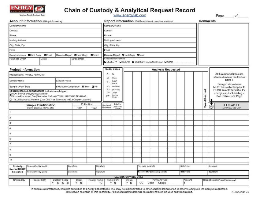
Lake/Reservoir Nutrient Monitoring
Sampling and Analysis Plan for 2021

Reviewed and Approved by:

                                                                  4/20/202
_____________________________________________________________________________
Jillian Scott, Qa/Qc Officer                                      1      Date
Wyoming Department of Environmental Quality

                                                                                    4/21/2021
__________________________________________________________________________________________________
Lindsay Patterson, Surface Water Quality Standards Supervisor                                Date
Wyoming Department of Environmental Quality

                                                                                   4/22/2021
__________________________________________________________________________________________________
Jeremy Zumberge, Surface Water Monitoring Program Supervisor                                 Date
Wyoming Department of Environmental Quality

                                                                                    4/20/2021
__________________________________________________________________________________________________
Eric Hargett, Natural Resource Program Principal (project manager)                           Date
Wyoming Department of Environmental Quality

Additional Reviewers                                                                  Date
 Jason Martineau, Natural Resource Analyst, Monitoring Program, WDEQ/WQD            4/14/2021
 Chad Rieger, Natural Resource Analyst, Monitoring Program, WDEQ/WQD                4/14/2021
 Triston Rice, Natural Resource Analyst, Monitoring Program, WDEQ/WQD               4/14/2021

                                                           i
TABLE OF CONTENTS
BACKGROUND AND OBJECTIVES......................................................................................................................................................... 1
CREDIBLE DATA AND QAPP ................................................................................................................................................................ 1
STANDARD OPERATING PROCEDURES ................................................................................................................................................ 1
STUDY DESIGN ................................................................................................................................................................................... 1
Number and Location of Sample Sites .......................................................................................................................... 1
Study Duration and Sample Frequency ......................................................................................................................... 3
Monitoring and Access Permissions ............................................................................................................................. 3
Primary WDEQ/WQD Field Personnel and Data Interpreters ........................................................................................ 3
Sample Parameters and Methods ................................................................................................................................ 4
Equipment (Electronic) Calibration, Maintenance and Calibration Logs ........................................................................ 5
Data Recording ............................................................................................................................................................ 6
Sample Labeling ........................................................................................................................................................... 6
Corrective Actions ........................................................................................................................................................ 6
Laboratories ................................................................................................................................................................. 6
QUALITY ASSURANCE/QUALITY CONTROL (QA/QC) ............................................................................................................................ 7
Data Verification and Validation ................................................................................................................................... 7
Chain of Custody .......................................................................................................................................................... 7
Field Quality Control for Chemical and Biological Samples (QC) .................................................................................... 7
Data Quality Objectives and Reconciliation .................................................................................................................. 7
Field Audits .................................................................................................................................................................. 7
DATA MANAGEMENT AND ARCHIVAL................................................................................................................................................. 8
Data Management ....................................................................................................................................................... 8
Data Archiving.............................................................................................................................................................. 8
ANALYSIS ........................................................................................................................................................................................... 8
REFERENCES ...................................................................................................................................................................................... 9
FIGURES
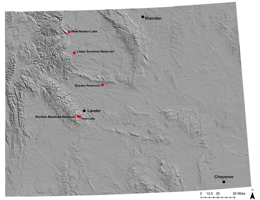
Figure 1 – Locations of the five reservoirs (red circles) selected for sampling in 2021 along with selected municipalities (black circles).
.......................................................................................................................................................................................................... 2
ii
BACKGROUND AND OBJECTIVES
The monitoring and water quality standards groups will embark on a ninth year of collecting nutrient and supporting data
on lakes and reservoirs. The focus of this year's monitoring will be a) drinking water storage reservoirs and/or public
reservoirs with high recreation uses for which limited or no nutrient data exist and b) Boysen Reservoir (WDEQ/WQD
2021). Data from this monitoring will be used to ascertain the status of nutrient conditions in these waters; to assist in
development of numeric nutrient criteria protective of aquatic life, recreation and/or drinking water; and be used to
determine whether these waters should be prioritized for protection and/or restoration as part of Wyoming’s Nutrient
Strategy (http://deq.wyoming.gov/wqd/nutrient-pollution/resources/wyoming-nutrient-strategy/). Data collected on
Boysen Reservoir will be used in conjunction with external data to i) verify predictions of cyanobacterial bloom densities
from CyAN satellite imagery (https://www.epa.gov/water-research/cyanobacteria-assessment-network-cyan), ii)
evaluate linkages between cyanobacterial composition and cyanotoxin production in Boysen Reservoir.

CREDIBLE DATA AND QAPP
All data are collected in accordance with the credible data law specified in the Wyoming Environmental Quality Act § 35-
11-103(c)(xix) and detailed in Chapter 1, Section 35 of the Wyoming Water Quality Rules and Regulations. This SAP is
covered by the WDEQ Water Quality Division (WQD), Watershed Protection Program Monitoring Quality Assurance
Program Plan (QAPP) (WDEQ/WQD 2021b).

STANDARD OPERATING PROCEDURES
All standard operating procedures (SOPs) referenced within this SAP are found within the Manual of Standard Operating
Procedures for Sample Collection and Analysis (WDEQ/WQD 2021c).

STUDY DESIGN
Site Selection
The following five public reservoirs are selected for monitoring in 2021 (Figure 1).

   Owner      Category    Reservoir                                Acres                Latitude            Longitude
   Public         1       Worthen Meadows Reservoir                  98                42.700600           -108.925100
   Public         2       Frye Lake                                 145                42.707500           -108.878900
   Public         3       Lower Sunshine Reservoir                  971                44.086770           -108.986800
   Public         1       West Newton Lake                           29                44.543590           -109.123710
   Public        BR       Boysen Reservoir                         19,560              43.367743           -108.175406

Number and Location of Sample Sites
For reservoirs that have not been previously sampled, the number and locations of sample sites will be determined during
the first sample period according to the sample site selection criteria in Table 1 based on the reservoir’s category (Category
1: 10-100 acres; Category 2: 101-500 acres; Category 3: 500+ acres; Category 3(LR): large reservoirs). For reservoirs that
have been previously sampled, monitoring will take place at established sample sites that correspond with the minimum
selection criteria in Table 1. For Boysen Reservoir (Category BR), monitoring will take place at existing site locations as
described in Table 2. Monitoring will take place at the same sample sites for all sample events.

                                                              1
Figure 1 – Locations of the five reservoirs (red circles) selected for sampling in 2021 along with selected municipalities (black circles).

                                                                                    2
Table 1 – Sample site selection criteria for each reservoir size class.
Category No. of Sites Site Location(s)
1 1 Open water pelagic – deepest location
2 1 Open water pelagic – deepest location
3 2 Deepest locations within the ‘lacustrine pelagic’ and ‘riverine-transitional pelagic’ zones. If there are
multiple ‘riverine-transitional pelagic’ zones, then select the zone that receives the largest inflow into
the lake.
3 (LR) 3 Deepest locations within the ‘riverine pelagic’, ‘transitional pelagic’ and ‘lacustrine pelagic’ zones. If
there are multiple ‘riverine pelagic’ zones, then select the zone that receives the largest inflow into the
lake.
Table 2 – Sample sites for Boysen Reservoir.
Site ID Site Name Latitude Longitude
WYDEQ_RES_303 Fremont Bay 43.251675 -108.184722
WYDEQ_RES_304 Tough Creek Campground 43.325483 -108.160000
WYDEQ_RES_305 East Shore 43.365706 -108.148611
WYDEQ_RES_68 Cottonwood Bay 43.346903 -108.212772
WYDEQ_RES_71 LPD 43.411997 -108.176744
WYDEQ_RES_67 TPD 43.302967 -108.201836
WYDEQ_RES_64 RPD 43.277556 -108.186297
Study Duration and Sample Frequency
The duration of lake sampling extends from April to October 2021. Each lake site will be sampled according to Table 4.
Table 1 – Sample duration and frequency for lakes identified in Table 1.
Reservoir Category Sample Period Sample Frequency Parameters
Mid to Late-June (Spring) Once Chemical, Physical and Biological
1 ,2, 3, and 3 (LR) Mid July to Early August (Summer) Once Chemical, Physical and Biological
Early to Mid-September (Fall) Once Chemical, Physical and Biological
BR April through October Monthly Chemical, Physical and Biological
Monitoring and Access Permissions
For access to or across private lands, authorization will be sought according to the internal standard operating procedure
(SOP) for Private Land Access and WDEQ/WQD Policy #5 WQD Private Property Access Procedures (Form B). Approved
private property access only applies to designated WDEQ staff and does not extend to other personnel/parties who may
wish to accompany WDEQ during sampling. Travel routes will be documented for all sites where private permission is
required to access or cross private lands.
Primary WDEQ/WQD Field Personnel and Data Interpreters
Sampler Office Title Contact Information
Tavis Eddy Lander, WY Natural Resource Analyst Ph: (307) 335-6957
tavis.eddy@wyo.gov
Mike Wachtendonk Lander, WY Natural Resource Analyst Ph: (307) 335-6751
michael.wachtendonk@wyo.gov
3Jason Martineau Sheridan, WY Natural Resource Analyst Ph: (307) 675-5632
jason.martineau@wyo.gov
Chad Rieger Sheridan, WY Natural Resource Analyst Ph: (307) 675-5637
chad.rieger@wyo.gov
Jeremy ZumBerge Sheridan, WY Monitoring Program Supervisor Ph: (307) 675-5638
jeremy.zumberge@wyo.gov
Triston Rice Cheyenne, WY Natural Resource Analyst Ph: (307) 777-6353
triston.rice@wyo.gov
Eric Hargett Cheyenne, WY Natural Resource Program Principal Ph: (307) 777-6701
eric.hargett@wyo.gov
Lindsay Patterson Cheyenne, WY Surface Water Quality Standards Ph: (307) 777-7079
Supervisor lindsay.patterson@wyo.gov
Sample Parameters and Methods
Parameter Sample Method / Sample Depth Reporting Analytical Preservative Holding Reporting
SOP From Water Units RU Method Time Limit (same
Surface units as RU)
Chemical
Alkalinity, Total Grab/ See SOP for 0.5 m mg/L SM2320B Iced topH See SOP for pH Entire Vertical S.U. SM4500-H+B None; FM N/A 0.01
Profile (See
Lake/Reservoir
Field Data Form)
**Phosphorus, Grab / See SOP for 0.5 m µg/L EPA 365.1 Filter (0.45µm), 48 hours 5.0
Orthophosphate Chemical Grab Iced toConductivity At least once weekly At least once daily before Re-condition according See SOP for Instrument
with either 100 or the first sample event to owner’s manual. Calibration and
1000 µS/cm standard with 100 or 1000 µS/cm Remove precipitate / Calibration Logs
(see owner’s manual) standard debris
Dissolved oxygen At least once weekly At least once daily Re-condition according See SOP for Instrument
(DO) or with each 500 ft before the first sample to owner’s manual. Calibration and
change in elevation event with water Remove precipitate / Calibration Logs
(see owner’s manual) saturated air at a known debris and keep probe
barometric pressure bulb moist
Temperature, An annual check None Remove precipitate / See SOP for Instrument
Water against a reference debris Calibration and
thermometer (NIST) Calibration Logs
Oxidation pH calibration is None Re-condition See SOP for Instrument
Reduction sufficient for ORP according to owner’s Calibration and
Potential (ORP) calibration manual. Remove Calibration Logs
precipitate / debris
and keep probe bulb
moist
Data Recording
All data and information collected in the field will be recorded on official WDEQ/WQD electronic datasheets and/or the
Lake/Reservoir Field Data Form that can be found at the back of this SAP. In some circumstances, field notebooks may also
be used in addition to the Lake/Reservoir Field Data Form or electronic datasheets. Samples for laboratory analysis will be
recorded on official chain of custody forms (see SOP for Chain of Custody).
Sample Labeling
See SOPs for Phytoplankton-Vertical Tow and Van Dorn Sample Method (attached), Chlorophyll (Lentic), and Sample
Labeling.
Corrective Actions
Project evaluation will occur periodically during the sampling schedule outlined in this SAP. Necessary revisions may
include but are not limited to site locations, sample methods and logistics, field forms and sampling logistics. Any revisions
will be included as amendments to this SAP. The project manager will notify all associated field personnel, landowners
and partners of amendments to this SAP along with implementation of any corrective actions.
Laboratories
The following laboratories will provide analytical services for samples collected as part of the project described in this SAP:
1. Wyoming Department of Environmental Quality, Water Quality Division Laboratory (WQD lab)
The WQD lab will be the provider of analytical services for all water chemistry samples (excluding orthophosphate)
collected as part of this project by WQD staff. The WQD lab will provide customized packages of bottles, labels,
preservatives, and chain of custody forms prior to samples being collected as requested by samplers. Samplers
will send samples to the WQD lab within one week of collection using United Parcel Service, Federal Express or
6hand delivery. The WQD lab will analyze samples in accordance with established standards for holding time,
analytical method, and data quality assurance and control. The WQD lab will follow the Watershed Protection
Program standard operating procedures (WDEQ/WQD 2021c) and QAPP (WDEQ/WQD 2021b).
2. Rhithron Associates (Rhithron)
Rhithron will provide taxonomic identification services for phytoplantkon samples collected as part of this project.
Rhithron has provided taxonomic services to the Watershed Program since 2004 and is under contract through
June 30, 2022. Preserved phytoplankton samples will be sent to Rhithron at the end of the field season. Rhithron
will provide results to samplers within 90 days of receipt of samples. Rhithron will subsample, sort and identify
specimens according to contract terms. Established standards for taxonomic identification will be followed.
3. Energy Laboratories, Casper Wyoming
Energy Laboratories will be the provider of analytical services for orthophosphate samples collected as part of this
project by WQD staff. Energy Laboratories will provide customized packages of bottles, labels, preservatives, and
chain of custody forms prior to samples being collected as requested by samplers. A copy of the chain of custody
used by Energy Laboratories is included in the back of this SAP. Samplers will send samples to Energy Laboratories
within one week of collection using United Parcel Service, Federal Express or hand delivery. Energy Laboratories
will analyze samples in accordance with established standards for holding time, analytical method, and their own
data quality assurance and control procedures.
QUALITY ASSURANCE/QUALITY CONTROL (QA/QC)
Data Verification and Validation
See SOPs for Data Validation and Data Verification as well as the Watershed Protection Program Monitoring Quality
Assurance Program Plan (QAPP) (WDEQ/WQD 2021b).
Chain of Custody
See SOP for Chain of Custody.
Field Quality Control for Chemical and Biological Samples (QC)
Field Qc Samples Collection Frequency Parameters
Field Blank At least 10% for all collected samples (Chemical) All listed, except FM
Duplicate At least 10% for all collected samples (Chemical and Biological) All listed
See SOP for Blanks and Quality Control Measures, Summary Of; FM = Field Measurement
Data Quality Objectives and Reconciliation
Data collected under this SAP will be evaluated by the Qa/Qc Officer with respect to the data objectives listed in this SAP
and data quality objectives identified in the WDEQ/WQD SOP for Precision and the QAPP (WDEQ/WQD 2021b). If it is
determined that one or more data objectives/components were not met, the project manager will be informed and given
an opportunity to provide justification to the Qa/Qc Officer as to whether the particular data objective/component should
be qualified or rejected and if future data components/objectives should be altered.
Field Audits
A field audit by the WDEQ/WQD QA/QC Officer will be accommodated if requested.
7DATA MANAGEMENT AND ARCHIVAL
Data Management
Data Type Storage Location
Chemical WDEQ/WQD Nutrient Database, spreadsheet and .pdf WDEQ/WQD Cheyenne,
Lander and Sheridan
Biological, Chlorophyll-a WDEQ/WQD Nutrient Database and Algal Database, spreadsheet and WDEQ/WQD Cheyenne,
.pdf Lander and Sheridan
Biological, Phytoplankton Algal Database, spreadsheet and .pdf WDEQ/WQD Cheyenne,
Lander and Sheridan
Physical WDEQ/WQD Nutrient Database, spreadsheet and .pdf WDEQ/WQD Cheyenne,
Lander and Sheridan
Data Archiving
Data Item Format Backup Copy & Format Location Retention
Field Data Sheets Electronic (.pdf, .xlsx, other) Electronic (.pdf) WDEQ/WQD Cheyenne, Permanent
& paper Lander and Sheridan
Photographs Electronic (.jpg) Electronic (.jpg) WDEQ/WQD Cheyenne, Permanent
Lander and Sheridan
Field Log Books Paper Electronic (.pdf) WDEQ/WQD Cheyenne, Permanent
Lander and Sheridan
Laboratory Results/Qa Electronic (.csv, .docx and Electronic (.csv, .docx and WDEQ/WQD Cheyenne, Permanent
pdf) pdf) Lander and Sheridan
Agency Qa Reports Electronic (.docx and .pdf) Electronic (.docx and .pdf) WDEQ/WQD Cheyenne, Permanent
Lander and Sheridan
Calibration Logs Electronic (.jpg) and paper Electronic (.pdf) WDEQ/WQD Cheyenne, Permanent
Lander and Sheridan
Chain of Custody Electronic (.xlsx and .pdf) and Electronic (.xlsx and .pdf) WDEQ/WQD Cheyenne, Permanent
paper Lander and Sheridan
Spreadsheets, other Electronic (.xlsx, .txt, .dbf, Electronic (.xlsx, .txt, .dbf, WDEQ/WQD Cheyenne, Permanent
electronic files other) other) Lander and Sheridan
Database Electronic (.mdb, other) Electronic (.mdb, other) WDEQ/WQD Cheyenne, Permanent
Lander and Sheridan
Reports, emails, Electronic (.wpd, .pdf, .html) Electronic (.docx, .pdf and WDEQ/WQD Cheyenne, Permanent
letters & paper .html) Lander and Sheridan
-All records are the property of the State and therefore subject to the Wyoming Public Records Act.
-Records may be transferred to the Wyoming State Archives according to procedures in the State Agency Crosswalk Schedule.
ANALYSIS
Analytical methods that could be used for development of nutrient criteria using data collected pursuant to this project
and other data sources include but are not limited to those identified in the Wyoming Nutrient Criteria Development Plan
(WDEQ/WQD 2018b). Data analysis efforts to accomplish identified objectives specific to Boysen Reservoir will be
conducted by a third-party under a separate sampling and analysis plan approved by the WDEQ.
8REFERENCES
WDEQ/WQD. 2021a. Water Quality Monitoring Plan. Wyoming Department of Environmental Quality, Water Quality
Division, Watershed Protection Program, Sheridan, Wyoming.
WDEQ/WQD. 2021b. Quality Assurance Project Plan (QAPP) for Watershed Protection Program Water Quality Monitoring.
Wyoming Department of Environmental Quality, Water Quality Division, Cheyenne, Wyoming.
WDEQ/WQD. 2021c. Manual of Standard Operating Procedures for Sample Collection and Analysis. Wyoming Department
of Environmental Quality, Water Quality Division, Cheyenne, Wyoming.
WDEQ/WQD. 2018a. Wyoming Water Quality Rules and Regulations – Chapter 1. Wyoming Department of Environmental
Quality, Water Quality Division, Cheyenne, Wyoming.
WDEQ/WQD. 2018b. Wyoming Nutrient Criteria Development Plan. Wyoming Department of Environmental Quality,
Water Quality Division, Cheyenne, Wyoming.
910
WYOMING DEPARTMENT OF ENVIRONMENTAL QUALITY
LAKE/RESERVOIR FIELD DATA FORM
LAKE/RESERVOIR DESCRIPTION (Complete Bold and Underlined Entries in Field)
DATE (mm-dd-yyyy) __ __ - __ __ - __ __ __ __ DEQ ID CODE __ __ __ __ __ __ __ MAJOR BASIN_____________________
WATERBODY NAME ________________________________________________________________________________________
SAMPLE SITE LOCATION (Check one location):
Deepest Region Riverine-Transitional Zone - Pelagic Lacustrine Zone - Pelagic
Riverine Zone- Pelagic Transitional Zone- Pelagic Lacustrine Zone- Littoral
Riverine Zone- Littoral Transitional Zone- Littoral
Other (Embayment, Tributary Inflow):_______________________________________________________________________________________
SAMPLING PURPOSE/PROJECT: Reference Random Targeted Spill/Complaint Other_______________________________
DATA COLLECTORS (and initials) _______________________________________________________________________________
Note: List all observers by name in the Field Notes.
HUC CODE __ __ __ __ __ __ __ __ __ __ __ __ DEQ SURFACE WATER CLASSIFICATION: 1 2 2ww 3 4 AB A B C D
Class Subcategory
ECOREGION: Level III________________________________________ Level IV_________________________________________
USGS MAP (1:24K) _______________________________________ BLM MAP (1:100K) _____________________________________
COUNTY _____________________________ COORDINATES ____1/4____1/4 SEC___ ___ T___ ___N R___ ___ ___W
GPS FIELD FILE _______ LATITUDE __ __. __ __ __ __ __ __ __ __ __ LONGITUDE __ __ __. __ __ __ __ __ __ __ __ __
ELEVATION ____________ft SURFACE AREA ___________ac (Circle one): Maximum Pool Normal Pool Minimum Pool
DRAINAGE AREA ____________mi2 LANDFORM (Circle one): Mountain Foothills Plains
LAND STATUS (Circle one): Private State County Municipal Military Tribal USFS BLM USFWS NPS DOE BOR
CONTACT ______________________________________________________________ PHONE (_____) _____ - _____________
ADDRESS __________________________________________________________________________________________________
RESULTS REQUESTED? Y N Notes: ___________________________________________________________________
DIRECTIONS TO WATERBODY: _____________________________________________________________________________
____________________________________________________________________________________________________________
____________________________________________________________________________________________________________
PRIMARY LAND USE (Circle one), SECONDARY LAND USE (Circle one & label #2) and LESSER LAND USES (Underline) within
immediate vicinity of shoreline. Non-irrigated Hayland Irrigated Hayland Non-irrigated Row Crop Irrigated Row Crop Livestock Grazing
Confined Feedlot Logging Industrial Urban Military Reserve Mining Oil & Gas Recreation & Wildlife Habitat Other_______________________________
PRESENT ON OR UPSTREAM OF WATERBODY? (Circle all that apply): Irrig. Diversion Irrig. Return Municipal Intake Dam Causeways
Road Crossings Connected Roads Channel Alteration (i.e., dredged, artificial embankments, concrete lined) Boat Launches Campgrounds Swimming Beaches
Summer Residences Permanent Residences Beaver Dams Fish Habitat Structures Fish Habitat Structures
FLOW AUGMENTATION? (Circle all that apply): None Point Discharge(s) Trans-Basin Flow Diversion Irrigation Return Artesian/Well(s)
Revised 3/26/2020 - 11 -WYOMING DEPARTMENT OF ENVIRONMENTAL QUALITY
LAKE/RESERVOIR FIELD DATA FORM
LAKE/RESERVOIR DESCRIPTION (Continued)
POINT SOURCE DISCHARGES: List name, permit number, and type (i.e., WWTF, oil treater, industrial) that discharge to waterbody and its
tributaries. Estimate distance from outfall to waterbody. List additional facilities in the Field Notes.
DISTANCE % FLOW
FACILITY NAME PERMIT NO. TYPE (Stream Miles) CONTRIBUTION
DESCRIBE AND PHOTO-DOCUMENT SOURCES OF POLLUTANTS VISIBLY CONTRIBUTING TO WATER
QUALITY CHANGE (i.e., point sources, urban runoff, connected disturbed areas and roads, road crossings):_____________________________
___________________________________________________________________________________________________________
DESCRIBE NATURAL FACTORS VISIBLY CONTRIBUTING TO WATER QUALITY CHANGE (i.e., highly erosive soils,
geologic features, springs, thermal features): _____________________________________________________________________
___________________________________________________________________________________________________________
DESCRIBE BEST MANAGEMENT PRACTICES (BMP’s) IN PLACE TO CONTROL NPS POLLUTANTS: ____________
___________________________________________________________________________________________________________
BEDROCK GEOLOGY (Love and Christiansen 1985)_____________________________________________________________________
____________________________________________________________________________________________________________
PREDOMINANT SOIL TYPE ________________________________________________________________ (NRCS County Soil Survey)
__________________________________________________________________________________________ (Munn and Arneson 1998)
GENERAL OBSERVATIONS
WEATHER CONDITIONS ________________________________________________________________________________________________
Any recent runoff due to precipitation or snow melt? Y N If yes, within how any days? (Circle all that apply): 1 2 3 4 5 >5
WATER SHEEN SLIMES COLOR ODORS
□ None □ None □ None □ None
□ Intermittent □ Rare □ Brown □ Anaerobic
□ Consistent □ Common □ Green □ Sewage
□ Free Product □ Abundant □ Gray □ H2S
□ Other_____________________ □ Other_____________________
SECCHI DISK TRANSPARENCY
TIME _________ CLOUD COVER _________ % SURFACE WATER CONDITIONS _________________________________
NO. 1: Disappears @ _________ m Reappears @ _________ m NO. 2: Disappears @ _________ m Reappears @ _________ m
AVERAGE TRANSPARENCY DEPTH ___________ m TOTAL WATER DEPTH AT SAMPLE SITE _____________________ m
CHLOROPHYLL α
DATE (mm-dd-yyyy) __ __ - __ __ - __ __ __ __ TIME ____________ SAMPLE ID ___ ___ ___ - ___ ___ - ___ ___ ___ - ____C
(Initials) - (Year) - (J. day) - (No.)
COLLECTION DEPTH __________ m QA DUPLICATE? Y N DUPLICATE ID ___ ___ ___ - ___ ___ - ___ ___ ___ - ____C
SAMPLE VOLUME FILTERED ________ mL FILTER MESH SIZE 0.7 µ Other?______ µ PRESERVED (Ethanol/Other)? Y N
Revised 3/26/2020 - 12 -WYOMING DEPARTMENT OF ENVIRONMENTAL QUALITY
LAKE/RESERVOIR FIELD DATA FORM
PHYTOPLANKTON
DATE (mm-dd-yyyy) __ __ - __ __ - __ __ __ __ TIME _______ SAMPLE ID ___ ___ ___ - ___ ___ - ___ ___ ___ - ____PLV or PLN
(Initials) - (Year) - (J. day) - (No.)
COLLECTION DEPTH __________ m QA DUPLICATE? Y N DUPLICATE ID ___ ___ ___ - ___ ___ - ___ ___ ___ - ____PLV or PLN
NET MESH SIZE: 76 µm Other _____ µm TOTAL WATER DEPTH: _______________________ m
ESTIMATED MAXIMUM WATER FILTERED (Vm) __________ L Vm = [a0.0652 * SAMPLE DEPTH * 3.1416 * 1000]
INITIAL SAMPLE VOLUME _______mL LUGOL’S PRESERVATIVE VOLUME _______mL TOTAL SAMPLE VOLUME _______mL
aWisconsin® Plankton Net Mouth Radius = 0.065 m
WATER SAMPLES
DATE (mm-dd-yyyy) ___ ___ - ___ ___ - ___ ___ ___ ___ QA DUPLICATE? Y N
Surface Sample ID ___ ___ ___ - ___ ___ - ___ ___ ___ - ___ S Duplicate Surface Sample ID ___ ___ ___-___ ___-___ ___ ___-___ S
(Initials) - (Year) - (J. day) - (No.) (Initials) - (Year) - (J. day) - (No.)
Bottom Sample ID ___ ___ ___ - ___ ___ - ___ ___ ___ - ___ B Duplicate Bottom Sample ID ___ ___ ___-___ ___-___ ___ ___-___ B
Location Time Parameter Container Preservative Preserved?
Alkalinity □ 500 mL P □ Other ____________ I Y N
[Total N (TN)] [Nitrate+Nitrite N] [Ammonia-N] □ 500 mL P □ Other ____________ 1+1 H2SO4, I Y N
________
[Total Phosphorus (TP)] □ 500 mL P □ Other ____________ 1+1 H2SO4, I Y N
Surface _______
Depth (m)
[Orthophosphate P] □ 500 mL P □ Other ___________ I Y N
[Total Microcystin Nodularin] [Cylindrosperrmopsin] □ 60 mL PETG Amber P □ Other___ I Y N
3mL 10x
[Anatoxin-a] [Saxitoxin] □ 40 mL Amber G □ Other ________ Diluent, I
Y N
Alkalinity □ 500 mL P □ Other ____________ I Y N
[Total N (TN)] [Nitrate+Nitrite N] [Ammonia-N] □ 500 mL P □ Other ____________ 1+1 H2SO4, I Y N
________ [Total Phosphorus (TP)] □ 500 mL P □ Other ____________ 1+1 H2SO4, I Y N
Bottom _______
Depth (m) [Orthophosphate P] □ 500 mL P □ Other ____________ I Y N
[Total Microcystin Nodularin] [Cylindrosperrmopsin] □ 60 mL PETG Amber P □ Other___ I Y N
3mL 10x
[Anatoxin-a] [Saxitoxin] □ 40 mL Amber G □ Other ________ Diluent, I
Y N
E. COLI
DATE (mm-dd-yyyy) __ __ - __ __ - __ __ __ __ TIME ____________ COLLECTION DEPTH __________ m
CONTAINER: IDEXX Whirl-Pak Other________ QA DUPLICATE? Y N VOLUME: 100 mL Other__________mL
BLANK PREPARED: Y N TIME BLANK PREPARED ___________ SAMPLES PRESERVED ON ICE? Y N
Revised 3/26/2020 - 13 -WYOMING DEPARTMENT OF ENVIRONMENTAL QUALITY
LAKE/RESERVOIR FIELD DATA FORM
FIELD/LAB INSTRUMENTS USED (Include Model and Serial Numbers)
pH: DISSOLVED OXYGEN:
_____________________________________________________________ ____________________________________________
TEMPERATURE: CONDUCTIVITY:
_________________________________________________ _________________________________________________
VERTICAL PROFILE MEASUREMENTS
For depths 3 meters, record measurements at: * the surface; and
* 1.0 meter intervals down to 15 meters; and
* 5.0 meter intervals from 15 to 30 meters; and
* 10.0 meter intervals below 30 meters to a depth 1.0 meter above the bottom.
Data File Name ______________________________________________________________________________________________
Temp Cond Temp Cond
Depth D.O. D.O. Depth D.O. D.O.
(µS/cm (µS/cm
(m) Time (C) pH (mg/L) (%) ORP (m) Time (C) pH (mg/L) (%) ORP
) )
Surface 11
0.5 12
1.0 13
1.5 14
2.0 15
2.5 20
3 25
4 30
5 40
6 50
7 60
8 70
9 80
10 90
Revised 3/26/2020 - 14 -WYOMING DEPARTMENT OF ENVIRONMENTAL QUALITY
LAKE/RESERVOIR FIELD DATA FORM
INSTRUMENT CALIBRATION CHECK (performed after field sample measurements are made)
Instrument Calibration Date1 Value of Check Standard Measured Value of Check Standard
pH (S.U.)
Sp. Cond. (µ S/cm @ 25ºC)
Dissolved Oxygen (% satn.) Not applicable Not applicable
1Refer to field sampler’s instrument calibration log book.
QA/QC ITEMS
WATER QUALITY TRIP BLANK? Y N TRIP BLANK SAMPLE ID ___ ___ ___ - ___ ___ - ___ ___ ___ - ____
WATER QUALITY FIELD BLANK? Y N FIELD BLANK SAMPLE ID ___ ___ ___ - ___ ___ - ___ ___ ___ - ____
Field form checked for completeness by (print full name): _______________________________________________ Date: _____________
Calculations performed by (print full name): _________________________________________________________ Date: _____________
Calculations checked by (print full name): ___________________________________________________________ Date: _____________
FIELD NOTES
____________________________________________________________________________________________________________
____________________________________________________________________________________________________________
____________________________________________________________________________________________________________
____________________________________________________________________________________________________________
____________________________________________________________________________________________________________
____________________________________________________________________________________________________________
____________________________________________________________________________________________________________
____________________________________________________________________________________________________________
____________________________________________________________________________________________________________
____________________________________________________________________________________________________________
____________________________________________________________________________________________________________
____________________________________________________________________________________________________________
____________________________________________________________________________________________________________
____________________________________________________________________________________________________________
____________________________________________________________________________________________________________
____________________________________________________________________________________________________________
____________________________________________________________________________________________________________
Revised 3/26/2020 - 15 -You can also read