Long-term field experiments in Germany: classification and spatial representation
←
→
Page content transcription
If your browser does not render page correctly, please read the page content below
SOIL, 6, 579–596, 2020

                                                                                                        SOIL
https://doi.org/10.5194/soil-6-579-2020
© Author(s) 2020. This work is distributed under
the Creative Commons Attribution 4.0 License.

                       Long-term field experiments in Germany:
                       classification and spatial representation
        Meike Grosse1 , Wilfried Hierold1 , Marlen C. Ahlborn1 , Hans-Peter Piepho2 , and Katharina Helming1
                                1 Leibniz   Centre for Agricultural Landscape Research (ZALF),
                                       Eberswalder Straße 84, 15374 Müncheberg, Germany
              2 Biostatistics Unit, Institute of Crop Science, University of Hohenheim, 70599 Stuttgart, Germany

                                   Correspondence: Meike Grosse (meike.grosse@zalf.de)

                                     Received: 14 May 2020 – Discussion started: 16 June 2020
                      Revised: 24 September 2020 – Accepted: 15 October 2020 – Published: 26 November 2020

       Abstract. The collective analysis of long-term field experiments (LTFEs), here defined as agricultural experi-
       ments with a minimum duration of 20 years and research in the context of sustainable soil use and yield, can
       be used for detecting changes in soil properties and yield such as those induced by climate change. However,
       information about existing LTFEs is scattered, and the research data are not easily accessible. In this study,
       meta-information on LTFEs in Germany is compiled and their spatial representation is analyzed. The study is
       conducted within the framework of the BonaRes project, which, inter alia, has established a central access point
       for LTFE information and research data. A total of 205 LTFEs which fit to the definition above are identified.
       Of these, 140 LTFEs are ongoing. The land use in 168 LTFEs is arable field crops, in 34 trials grassland, in 2
       trials vegetables and in 1 trial pomiculture. Field crop LTFEs are categorized into fertilization (n = 158), tillage
       (n = 38) and crop rotation (n = 32; multiple nominations possible) experiments, while all grassland experiments
       (n = 34) deal with fertilization. The spatial representation is analyzed according to the climatic water balance
       of the growing season (1 May to 31 October) (CWBg), the Müncheberg Soil Quality Rating (MSQR) and clay
       content. The results show that, in general, the LTFEs well represent the area shares of both the CWBg and the
       MSQR classes. Eighty-nine percent of the arable land and 65 % of the grassland in Germany are covered by
       the three driest CWBg classes, hosting 89 % and 71 % of the arable and grassland LTFEs, respectively. LTFEs
       cover all six MSQR classes but with a bias towards the high and very high soil quality classes. LTFEs on arable
       land are present in all clay content classes according to the European Soil Data Centre (ESDAC) but with a
       bias towards the clay content class 4. Grassland LTFEs show a bias towards the clay content classes 5, 6 and 7,
       while well representing the other clay content classes, except clay content class 3, where grassland LTFEs are
       completely missing. The results confirm the very high potential of LTFE data for spatially differentiated analyses
       and modeling. However, reuse is restricted by the difficult access to LTFE research data. The common database
       is an important step in overcoming this restriction.

1   Introduction                                                   with a long duration are needed. However, a single LTFE al-
                                                                   lows for the drawing of conclusions only for its specific site.
Long-term field experiments (LTFEs) are a valuable research        The collective analysis of research data from different LT-
infrastructure for terrestrial research in general and in agri-    FEs at different locations leads to more generalizable results.
cultural research in particular. They are here defined as          On the one hand, similar experiments on similar sites will
agricultural field experiments with a minimum duration of          lead to better validated conclusions when analyzed in com-
20 years and research in the context of sustainable soil use       bination. On the other hand, LTFEs in different experimen-
and yield. Changes in soil properties tend to occur slowly;        tal conditions may lead to broader implementable results by
thus, for the identification of long-term trends, experiments

Published by Copernicus Publications on behalf of the European Geosciences Union.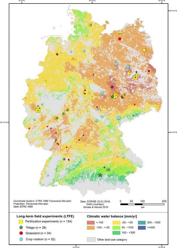
580                    M. Grosse et al.: Long-term field experiments in Germany: classification and spatial representation

their collective analysis. Furthermore, LTFEs are expensive;       However, because of the site specificity of soil–plant inter-
a comprehensive and coordinated evaluation is also required        actions and their responses to agricultural management prac-
to prove that they are worth the expense (Körschens, 2006;         tices, the upscaling and generalization of results require in-
Berti et al., 2016). Historically, LTFEs were mainly estab-        formation about the spatial representation of LTFE sites.
lished to answer questions regarding plant nutrition in the           The statistical analysis of LTFEs poses several challenges
sense of achieving the highest possible yield (Merbach and         and requires careful statistical modeling. We would recom-
Deubel, 2008). Later, they were used to reveal the effects         mend a mixed-model-based analysis that accounts for the
of agricultural management practices (besides fertilization        randomized layout of the trial (see Onofri et al., 2016, for
mainly tillage and crop rotation) on crop yield but also soil      a review and some case studies). A general strategy starts
characteristics. LTFEs have been very helpful for research         out from the analysis model that would be used for a single
on soil organic carbon content or composition (Ellerbrock          year of data and then extends the model to account for vari-
and Gerke, 2016; Kaiser et al., 2014; Körschens et al., 2014).     ation across years. A specific challenge here is that during
LTFEs are further important for research related to questions      the course of the experiment several observations are made
regarding the interannual variability of crop yield (i.e., yield   on the same experimental units, and this serial correlation
stability) that can be associated with climate change (Berti et    needs to be taken into account (Payne et al., 2015; Richter
al., 2016; Reckling et al., 2018; Macholdt et al., 2019a) and      and Kroschewski, 2006; Singh and Jones, 2002). Also, there
respective adaptation options (Hamidov et al., 2018). Valu-        may be heterogeneity of variance between years, which may
able data can also be delivered for the validation of models       be related to changes in stability of the investigated systems
(Franko et al., 2011; Ellerbrock et al., 2005) and for concepts    (Macholdt et al., 2019a, b).
used to evaluate soil functions (Vogel et al., 2019; Techen et        A common issue with several LTFEs in Germany is that
al., 2020).                                                        they were not properly randomized. This is mainly due to the
    The joint analysis of LTFEs can go beyond the original re-     fact that Fisher’s principles of randomization and blocking
search question of each LTFE, e.g., to answer questions about      were not widely known or accepted at the time when these
climate change, ecosystem services, nutrient cycles or yield       trials were established. Instead, the systematic design orig-
stability. This research could be done through the common          inally proposed by Mitscherlich about a hundred years ago
assessment of the “control” treatment of each LTFE, which          was very popular, and several LTFEs were established ac-
is here defined as a treatment with customary tillage and fer-     cording to such systematic designs. For these unrandomized
tilization and is present in most LTFEs. The combined anal-        trials, a randomization-based analysis is obviously not avail-
ysis of control treatments is irrespective of the LTFE’s orig-     able. One option then is to try spatial modeling, though it
inal research theme. This would allow us to reveal changes         must be stressed that fitting of a spatial covariance structure
in soil properties independently of the original questions for     cannot make up for a lack of randomization. But such a mod-
which the experiments were set up, e.g., overall trends in car-    eling is perhaps the best way forward if a sensible analysis is
bon content development. Although that would be a simi-            to be conducted for such trials. For a review of the connec-
lar analysis to what can be done with soil monitoring sites        tion between systematic designs as proposed by Mitscherlich
(“Bodendauerbeobachtungsflächen”, i.e., a permanent mon-           and certain spatial covariance structures, see Piepho and Vo-
itoring program where the federal states of Germany have           Thanh (2020).
the responsibility for recording changes in soils of cropland,        Important compilations of German LTFEs have been per-
grassland, forests and specialized crops), it would be a rea-      formed by Körschens (1994, 1997) and Debreczeni and
sonable approach. It can be assumed that LTFEs have fewer          Körschens (2003). In Körschens (1994), 97 German LTFEs
breaks during the experimental period than soil monitoring         with a duration of more than 20 years were listed. The start-
sites, as soil monitoring sites are always a “window” into         ing year, the kinds of factors, the cultivated crops, the size
real agriculture. Further on, access to data from soil moni-       of the plots and experiments, the soil texture, the average an-
toring sites is not necessarily easier than that to LTFEs. Of      nual air temperature, and the average annual precipitation of
course, the strengths of the collective analysis of LTFEs is       the site are presented if available. In Körschens (1997), 50
the analysis of LTFEs with similar treatments in the form of       German LTFEs with a duration of more than 30 years are
a meta-analysis.                                                   listed, and similar information is presented. In Debreczeni
    The meta-analyses of similar LTFEs, e.g., of fertilizer ex-    and Körschens (2003), 94 German LTFEs with a duration
periments with similar factors (e.g., with or without organic      of more than 20 years are listed, and information about the
manure) or tillage experiments (e.g., conventional tillage vs.     start, experimental aspects, cropping system and soil is pro-
reduced tillage), have the opportunity to make use of the          vided. Körschens (1994, 1997) indicate the following con-
original research question of the LTFE. The effects and sus-       straints for the compilation of a complete overview of all
tainability of measures can be revealed in a broader context       LTFEs in Germany: the multitude of experiments, discontin-
and in different soils. This can be done with pairwise com-        ued experiments, new experiments or experiments not at all
parisons of alternative and reference management practices,        documented in the literature. In Debreczeni and Körschens
such as that by Bai et al. (2018) and Sandén et al. (2018).        (2003), restricted resources for data collection are also men-

SOIL, 6, 579–596, 2020                                                                 https://doi.org/10.5194/soil-6-579-2020
M. Grosse et al.: Long-term field experiments in Germany: classification and spatial representation 581
able), institution, land use category, participation in existing
networks, research theme, size of the LTFE area, number of
plots, size of the plots, crop rotation, start (and maybe end)
of the trial, measured parameters and trial setup including
factors, treatments and randomization. For the coordination
and simplification of the trial description, the BonaRes fact
sheet was established, which asks for all relevant trial infor-
mation (Grosse et al., 2019). It was sent to the trial holders,
and the fact sheet was completed for 40 trials. Trial hold-
ers also delivered important information as personal com-
munication. In compiling the dataset, special attention was
Figure 1. Methods used for assessing the representativeness of the
paid to LTFEs with a minimum duration of 20 years. This
LTFE distribution in Germany.
age can be seen as a threshold for the identification of long-
term trends. Attention was given to LTFEs in the context of
soil research, i.e., the objects of research should at least in-
tioned. In addition, the heterogeneous setup and the scat-
clude soil properties and yield as an important soil function.
tered distribution of LTFEs make comparisons of data diffi-
The setup of each trial should allow for statistical analyses,
cult or impossible (Bai, 2018). To cope with these problems,
i.e., have clearly defined treatment factors, replications and
in the frame of the project “BonaRes”, funded by the Ger-
as much as possible a static design. Lysimeter experiments
man Federal Ministry for Education and Research (BMBF),
were excluded because they were considered their own cat-
there is a focus on a central database for metadata and re-
egory. Some reasons for this exclusion are that soils are of-
search data from LTFEs (BonaRes, 2020). The research data
ten transferred and not undisturbed in lysimeter experiments,
from two LTFEs (V140, Müncheberg and Dikopshof, Bonn)
and tillage has to be conducted by hand instead of machines,
are available for free reuse via the BonaRes data portal
which can bias some results. Indeed, long-term lysimeter ex-
(https://maps.bonares.de/mapapps/, last access: 20 Novem-
periments exist in Germany as part of the TERENO network
ber 2020) and the research data of nine other LTFEs are very
(TERENO, 2020).
close to publication. More LTFE holders will hopefully agree
The LTFEs were classified according to their research
to upload research data within the third (and last) funding
themes to simplify the identification of similar experiments.
phase of BonaRes and take the great chance for support in
The field crop LTFEs could best be grouped into four clus-
data processing and storage.
ters: fertilization, tillage, crop rotation and other. The fourth
No information is yet available regarding the spatial rep-
cluster “other” entails all themes that could not be grouped
resentation of LTFEs in Germany with regard to important
into the first three and appeared only in a few (maximum five)
agronomic factors such as climate and soil fertility. The aim
LTFE cases, so a separate group was not justified. Two or
of this paper was twofold. First, to classify the LTFEs in Ger-
more factorial experiments were sorted in all relevant classes;
many with regard to land use, research themes and farming
i.e., multiple nominations were possible. LTFEs on grassland
systems. Second, the aim was to conduct a descriptive anal-
exist only as fertilization trials.
ysis of the geospatial distribution of the experimental sites
There are 109 LTFEs precisely known in their position,
with regard to key factors of agricultural production: climate
and for an additional 96 LTFEs, the trial area is approxi-
and soil fertility.
mately known, usually on the area of the holding institution.
In the latter case, either the exact position is not known or the
2 Material and methods former LTFEs are now overbuilt with streets, parking spaces
or buildings.
A combination of three methods was applied: a literature re- The geospatial analysis was performed by comparing the
view to identify LTFEs in Germany, a fact-sheet-based addi- regional distribution of LTFEs to that of (a) climatic water
tion of information to the identified LTFEs and a geospatial balance classes of the growing season (1 May to 31 Oc-
analysis employing the CWBg and the MSQR (Fig. 1). tober) (CWBg) and (b) the Müncheberg Soil Quality Rat-
An extensive literature review was conducted to identify ing (MSQR) as two complex site classifications. In addition,
LTFEs. The search terms were “long-term field experiment”, (c) clay content of the topsoil according to ESDAC (2020)
“long-term experiment”, “long-term field trial” and “long- was chosen. The representativeness of LTFEs according to
term trial”, as well as the German terms “Dauerfeldversuch”, the frequencies in the cells of this classification was assessed.
“Dauerdüngungsversuch”, “Dauerversuch”, “Langzeitfeld- LTFEs were classified according to their land use and their
versuch” and “Langzeitversuch”. Sources were scientific pa- research themes to simplify the identification of similar ex-
pers as well as other articles, books, trial guides and web- periments. The identification of suitable LTFEs in similar (or
sites. The focus was on the exact position of the LTFE and different) landscapes shall be facilitated. Therefore, a table
the following metadata: name of the LTFE, website (if avail- with the IDs of all experiments, their thematic classification,
https://doi.org/10.5194/soil-6-579-2020 SOIL, 6, 579–596, 2020582 M. Grosse et al.: Long-term field experiments in Germany: classification and spatial representation
their CWBg class and their MSQR class is provided in the For point (b), a soil quality map (BGR, 2014) is used,
Appendix. More details for each LTFE can be identified in which applies the Müncheberg Soil Quality Rating (MSQR).
the published dataset (Grosse and Hierold, 2019), which is It has a pixel resolution of 250 m. The Institute for Geo-
freely available in the BonaRes Repository, by the ID of the sciences and Natural Resources (BGR) had applied this com-
LTFE. Thus, cooperation with LTFE holders can be initiated plex assessment procedure (Mueller et al., 2010; Ad-hoc-AG
more easily. Fourteen LTFEs were excluded from the geospa- Boden, 2010), which was developed as a visual procedure
tial analysis because they were dealing with research themes for estimating yield potential in the field, by modeling data
other than fertilization, tillage or crop rotation, or they did from the soil overview map (BGR, 2007), but only for arable
not include field crops or grassland experiments. The remain- land. It takes soil structure and soil degradation threats into
ing 191 LTFEs were grouped into the following four classes: account and integrates 8 basic soil indicators with 13 hazard
fertilization experiments, tillage experiments, grassland ex- indicators into a rating of soil quality. The rating is shown
periments and crop rotation experiments. The shares of LT- on an ordinal scale of 0 to 102 and clustered into six qual-
FEs in each class were compared to those of agricultural ity classes, with higher values indicating higher yield po-
land in Germany. For that, approximately 17.9 × 10⁶ ha of tential (Daedlow, 2018). The 8 soil indicators are substrate,
agricultural land was subdivided according to its land use as A-horizon depth, topsoil structure, subsoil structure, root-
arable land (approximately 13.5 × 10⁶ ha) or grassland (ap- ing depth, profile available water, wetness and ponding, and
proximately 4.4×10⁶ ha) (Umweltbundesamt, 2019). For the slope and relief. The 13 hazard indicators are contamination,
descriptive statistical analyses, cross-tabulations and contin- salinization, sodification, acidification, low total nutrient sta-
gency tables were used. tus, shallow soil depth above hard rock, drought, flooding and
The CWBg was chosen as a suitable parameter to repre- extreme waterlogging, steep slope, rock and surface, high
sent the climatic conditions for agricultural land use and be- percentage of coarse texture fragments, a soil thermal regime
cause of its huge relevance for vegetation growth. Its impact unsuitable for crop production, and miscellaneous hazards
may be even larger than that of temperature (Crimmins et al., (e.g., exposure to wind and water erosion). Most of the indi-
2011), and it may determine the growing season (Sattar et al., cators are sensitive to agricultural management, which makes
2019). We used data from the German Meteorological Ser- the MSQR most useful for studying the effects of agricul-
vice (DWD) for the period 1981–2010 for the main growing tural management on soil. The MSQR has been proven use-
season, defined from 1 May to 31 October (Ad-hoc-AG Bo- ful in other studies of geospatial representation (Askari et
den, 2005). The climatic water balance (CWB) data for the al., 2013; Hanauer et al., 2017; Smolentseva et al., 2014).
growing season instead of the whole year were chosen, be- Since no MSQR is available for grassland areas, the LTFEs
cause regional differentiation is bigger for CWBg compared on grassland were excluded in this analysis.
to the annual balance. The data are available for the whole Out of the 157 fertilization, tillage or crop rotation LTFEs
territory of Germany with a pixel resolution of 1 km (DWD, on arable land, 26 could not be assigned to a class of MSQR,
2020). The CWB is defined in Eq. (1) as the difference in because the fields were surrounded by buildings and were
precipitation (P ) and potential evapotranspiration (PET). It therefore not part of arable land. If an LTFE did not obtain
is a quantitative measure of the water supply in a given time an assignment at a GIS (geographic information system) in-
period and for a specific region. The PET depends on loca- tersection, the value was determined manually by plausible
tion factors such as crop cover, topographical effects, soil examination of the nearest five to seven grid cells. One LTFE
conditions and soil water storage. It can therefore only be could not be assigned to a class of MSQR because it com-
determined selectively. However, for a better comparison for pares three different soils in boxes.
spatial calculations, the so-called grass reference evapotran- For point (c), clay content, data of the European Soil Data
spiration is considered, which indicates the evapotranspira- Centre (ESDAC) based on LUCAS topsoil data are used (ES-
tion of a standardized grass cover in standardized soil with DAC, 2020). Although clay content is included in the MSQR
optimal water supply (Pereira et al., 2015). as part of substrate, we decided to analyze the area shares of
clay content separately, as carbon content is often correlated
CWB = P − PET (1) with the clay content (Körschens, 1997). Moreover, clay con-
tent is needed to estimate the carbon balance in a model de-
The classification of the climatic water balance into seven rived from the CANDY model (Franko et al., 2011). Further-
classes follows the German Soil Survey Guidelines KA5 more, ESDAC offers international data; therefore, clay con-
(Ad-hoc-AG Boden, 2005) (≤ 150 mm; −150 to < −50 mm; tent is suitable for international comparability. Due to the fact
−50 to < 50 mm; 50 to < 150 mm; 150 to < 300 mm; 300 to that texture is part of the MSQR, we do not offer separate
< 500 mm; ≥ 500 mm), which are classified there from ex- maps for clay content but present data in tables.
tremely low to extremely high (Ad-hoc-AG Boden, 2005). Calculations always refer to utilized agricultural areas or
To derive data for agricultural areas, either arable land or parts thereof, arable land or grassland.
grassland intersections with the CORINE Land Cover (CLC,
2018) dataset were made.
SOIL, 6, 579–596, 2020 https://doi.org/10.5194/soil-6-579-2020M. Grosse et al.: Long-term field experiments in Germany: classification and spatial representation 583
plains the high number of LTFEs established in these years
(Fig. 3).
The research themes of the LTFEs can be assigned to the
following categories: fertilization, tillage, crop rotation, other
themes and combinations of these (Table 1). Due to trials
with two or more treatment factors, multiple nominations of
experiments for the different research themes were assigned
(n = 251). Most LTFEs were established for research on fer-
tilization (Fig. 3 and Table 1) (n = 158). This result is coinci-
dent with the results from a study in the international context
Figure 2. Number of LTFEs per age in 2019 (n = 183; age of 22 (Berti et al., 2016). In Germany, fertilization LTFEs can be
LTFEs unknown). subdivided into field crop experiments (n = 124) and grass-
land experiments (n = 34). Historically, questions regarding
the effects of fertilization on plant growth were the focus of
The information was analyzed with Microsoft Excel. The research, while more recently the effects on the soil and the
geospatial analysis was performed using the ESRI software environment are investigated. The focus of the experiments is
ArcMap 10.6.1 (ESRI, 2018). different kinds of fertilizers, different amounts of fertilizers,
The research on LTFEs is not completed but is ongo- comparisons with or without a specific fertilizer, or combi-
ing. The information about LTFEs is continuously updated nations of these. Most frequently, organic fertilization versus
and expanded. New LTFEs are integrated, and the informa- mineral N fertilization is examined. In fewer experiments,
tion about each LTFE is extended. The state of research is the effect of straw fertilization is the subject of research. Ad-
November 2019. ditionally, the effects of mineral K fertilization, mineral P
fertilization, liming, green manure, mineral Mg fertilization,
compost or sludge are examined (Table 1). More rarely, dif-
3 Results and discussion
ferent points in time of the fertilizing measure are compared.
3.1 Overview of LTFEs in Germany Thirty-eight LTFEs address tillage variations (Table 1).
Most of these tillage experiments compare different tillage
In total, 205 LTFEs across Germany with a minimum intensities. Most often, reduced tillage depth or conservation
duration of 20 years were identified, of which 140 tri- tillage are the subjects of research. Also, inversion versus
als are ongoing and 65 are terminated (status: Novem- non-inversion tillage is compared. Further research themes
ber 2019). Further LTFEs reaching the 20-year thresh- are sowing methods, different forms of primary tillage, the
old within the next 5 years (until 2024) were also in- effects of stubble tillage and tillage frequency (Table 1).
cluded (n = 6; Fig. 2). Most of the trials have a dura- The oldest tillage experiment started in 1923 (Statischer
tion between 20 and 49 years (n = 124; Fig. 2). Fifty tri- Dauerversuch Bodennutzung, Berlin-Dahlem), but 25 tillage
als have a duration between 50 and 99 years. Three tri- experiments started in 1990 or later (Fig. 3). Therefore, most
als have been running for more than 100 years (“Ewiger of the tillage experiments are “younger” experiments, a result
Roggen”, Halle, 1878–today; “Statischer Düngungsversuch also congruent with the findings by Berti et al. (2016).
V120”, Bad Lauchstädt, 1902–today; “Dauerdüngungsver- Thirty-two LTFEs have the research theme “crop rota-
such Dikopshof”, Wesseling, 1904–2009). The age of 22 ter- tion”. Mostly, the effect of crop rotation on soil properties
minated trials is unknown since only the starting date of the and yield is investigated. Therefore, rotational cropping ver-
trials is known but not the exact ending year. As these trials sus monoculture is compared. Additionally, plant health is
were mentioned in different important sources as being ongo- the focus, e.g., compatibility of different cereal species or dif-
ing (Amberger and Gutser, 1976; Debreczeni and Körschens, ferent percentages of cereals in crop rotation (Table 1). Most
2003; Körschens, 1990, 1994, 1997, 2000), it is known that of the crop rotation experiments were established after 1950.
their duration was at least 20 years. Nineteen experiments of the 32 crop rotation experiments are
The land use in 168 LTFEs is arable field crops, in 34 still ongoing. The oldest crop rotation experiment, the “Eter-
trials grassland, in 2 trials vegetables and in 1 trial pomi- nal Rye”, was established in 1878 by the Martin Luther Uni-
culture. There are more long-term grassland experiments in versity of Halle.
Germany; we have not included them in our research because Twenty-three trials address research themes other than fer-
they are dedicated to research themes other than questions of tilization, tillage or crop rotation. The other research themes
sustainable soil use and yield. are highly diverse. “Environmentally friendly crop protec-
The majority of LTFEs were established after 1947, when tion”, mainly reduced pesticide intensity, is the most frequent
research was resumed after the Second World War (Fig. 3). research theme among the other research themes (n = 5). “Ir-
In 1996/1997, a series of grassland fertilization experiments rigation” is the second most frequent (n = 4). “Effects of dif-
was established by several German state authorities. This ex- ferent forms of fallow” is within the focus of three LTFEs.
https://doi.org/10.5194/soil-6-579-2020 SOIL, 6, 579–596, 2020584 M. Grosse et al.: Long-term field experiments in Germany: classification and spatial representation
Figure 3. Number of LTFEs set up per year according to the research themes of the experiments (multiple nominations possible, n = 251)
and total number of LTFEs per year (meaning established LTFE minus terminated LTFE).
“Frequency and start of utilization of grassland”, “Land use ternational networks such as the working group IOSDV (In-
systems comparison”, “Monitoring of organic farming” and ternationale Organische Stickstoffdauerdüngungsversuche;
“Use of biodynamic preparations” are each within the focus Körschens, 2000), the GLTEN (Global Long-Term Experi-
of two LTFEs. Three other research themes are present in ment Network, which was launched in 2018; GLTEN, 2020)
only one LTFE (Table 1). and networks of organic LTFEs like RetiBio in Italy and the
Many different parameters are measured in LTFEs. In RotAB network in France (Ciaccia et al., 2020). In order to
Grosse et al. (2019), 46 different soil parameters and 29 plant make the best use of the great efforts and costs that are behind
parameters are listed, which were measured in LTFEs. The every single LTFE, international networks should cooperate
analyzed parameters can be assigned to different soil func- more intensively in future and possibly also use data infras-
tions. The following five soil functions were chosen as most tructure jointly. We would like to point out that the BonaRes
relevant for BonaRes: biomass production, water storage and data repository can also be used by international data holders.
filtering, nutrient storage and recycling, carbon storage, and All information about the LTFEs in Germany is published
habitat for biological activity. In most LTFEs, parameters for in an online overview map (https://ltfe-map.bonares.de, last
biomass production were measured like yield and yield com- access: 20 November 2020). The aims of the overview map
ponents. Nutrient storage and recycling is the second most are to make LTFEs more visible, to enhance networking
frequent soil function. Less research is conducted (in de- among LTFEs and to simplify joint analyses of LTFEs. It is
creasing frequency) for carbon storage, habitat for biologic available in German and English. The map content can be
activity, and water storage and filtering. displayed according to different categories, e.g., the research
Archived samples are an important means of perform- themes, land use or duration of the LTFEs. In addition to the
ing or repeating measurements. However, the information (if overview information, details about every single LTFE are
archived samples exist) is difficult to find in the literature. We provided in a pop-up window, offering valuable information
have the information from a fact sheet query. for potential users for orientation and initiation of coopera-
Of 40 responses received, 32 LTFEs have archived sam- tion.
ples. A total of 184 trials are set up with conventional man- As limitations of existing LTFEs, it can be mentioned that
agement practices, 14 with organic management practices erosion and compaction are typically not analyzed in LT-
and five with so-called integrated agriculture. Two trials com- FEs, and they are not designed for such questions up to
pare conventional with organic management practices. now. Grassland experiments are in fact meadow experiments,
The holding institution for 96 trials is a university or uni- whereas grazing experiments are completely missing.
versity of applied sciences, and for 61 trials, it is a state au-
thority. Twenty-seven trials are in the responsibility of non- 3.2 Geospatial analyses
university scientific institutions such as research institutes.
21 trials are or were held by industry. 3.2.1 Geospatial analysis of LTFEs in relation to the
Compared to LTFEs worldwide, there are a compara- climatic water balance of the growing season
tively large number of LTFEs in Germany. Our research re- (CWBg) distribution
vealed (up to now) 177 LTFEs which match our definition
An overview of the distribution of these CWBg classes and
in the following countries: Austria, Belarus, Belgium, Bul-
of LTFEs in Germany is given in Fig. 4. According to Ta-
garia, China, Czech Republic, Denmark, Estonia, Finland,
ble 2 and Fig. 4, arable land is distributed among classes
France, Hungary, Ireland, Italy, Moldova, Norway, Poland,
1–7 of the CWBg (Table 2; Fig. 4): the largest shares of
Romania, Russia, Slovenia, Spain, Sweden, Switzerland,
33 % each are classified as CWBg classes 2 (from −150 to
UK, Ukraine and USA. They are comparable in age (the old-
< −50 mm) or 3 (from −50 to < 50 mm), respectively. The
est ones started in 1843) and research themes. There are in-
area of CWBg class 2 is mainly located in the lowlands of
SOIL, 6, 579–596, 2020 https://doi.org/10.5194/soil-6-579-2020M. Grosse et al.: Long-term field experiments in Germany: classification and spatial representation 585
Table 1. Research themes in LTFEs (multiple nominations possible, Germany: in the western and northern Rhine-Main valley, in
sorted by frequency). a majority of the northeastern lowland and an area around
Magdeburg called the Loess Boerde. The area of CWBg class
Theme Number 3 is mainly distributed in the northeastern part of Germany as
of trials well as in parts of the South German Escarpments landscape,
Fertilization – field crop experiments 124 the northern foothills of the Alps (lower Bavarian upland)
and the lower uplands, such as the Lower Saxon and Hessian
Manure fertilization 58
lowlands, the Vogtland district (a region in the border area
Mineral N fertilization 55
Straw fertilization 24 of Bavaria, Saxony, Thuringia and Bohemia) and the Ore
Mineral K fertilization 15 Mountain foreland. Twenty-three percent of the arable land
Mineral P fertilization 14 is allotted to CWBg class 1 (< −150 mm). This extremely
Liming 10 low CWBg is located almost exclusively in eastern Germany,
Green manure (with vs. without) 8 especially in the rain shadow of the Harz: the Fläming (a
Mineral fertilization (not specified) 6 landscape in southwest Brandenburg and eastern Saxony-
Mineral Mg fertilization 4 Anhalt), the plates and lowlands of mid Brandenburg and the
Compost 3 heathland of Brandenburg. Minor shares of 7 % and 4 % are
Sludge 2
allotted to CWBg classes 4 (from 50 to < 150 mm) and 5
Tillage – field crop experiments 38 (from 150 to < 300 mm), respectively. CWBg class 4 is lo-
Reduced depth or conservation tillage 24 cated mainly in the foothills of the Alps as well as around the
Inversion vs. non-inversion tillage 12 secondary mountains and in the western Schleswig-Holstein
Sowing methods 10 (moraines of Schleswig-Holstein). CWBg class 5 is mainly
Different forms of primary tillage 7 located in Germany’s southern foothills of the Alps. CWBg
Stubble tillage (with vs. without) 3 class 6 (from 300 to < 500 mm) is not present in Germany’s
Tillage frequency 3 arable land and CWBg class 7 (> 500 mm) is not present in
Other 2 Germany’s agricultural land (arable and grassland).
Fertilization – grassland experiments 34 Among the grassland, the largest share of 33 % is clas-
sified as CWBg class 3 (Table 3). Twenty-three percent of
Mineral P fertilization 11
Mineral K fertilization 10
grassland is classified as CWBg class 5. Eighteen percent
Mineral N fertilization 6 is classified as CWBg class 2, 14 % as CWBg class 1 and
Liming 4 9 % as CWBg class 4. CWBg class 6 is present in a small
Manure fertilization 2 share (3 %) of Germany’s grassland at higher altitudes in the
Sludge 2 Alpine region.
Mineral fertilization (not specified) 1 To analyze sites in every CWBg class, each class would
Acid vs. alkaline fertilization 1 have to be represented through LTFEs. Ideally, the shares
Crop rotation – field crop experiments 32 of LTFEs in each class would correspond to the agricultural
area. This is, of course, not the case (Table 2), as LTFEs were
Crop rotation (not specified) 23
not established systematically in the landscape. Each CWBg
Rotational cropping vs. monoculture 4
Effect of pre-crop 2
class present in the arable land is represented by LTFEs, but
Crop rotation organic vs. integrated 1 they are not found in the same shares. CWBg class 1 is over-
Different percentages of cereals 1 represented by all LTFE types, CWBg class 2 is underrep-
Different percentages of wheat 1 resented by crop rotation LTFEs, class 3 is underrepresented
by fertilization LTFEs and crop rotation LTFEs, class 4 is
Other – field crop and grassland experiments 23
underrepresented by tillage LTFEs and overrepresented by
Crop protection 5 crop rotation LTFEs (although in number there are only four
Irrigation 4 crop rotation LTFEs), and class 5 again is overrepresented
Effects of different forms of fallow 3 by crop rotation LTFEs (although in number there are only
Frequency and start of utilization of grassland 2
six crop rotation LTFEs) (Table 2; Fig. 4) Overall, the three
Land use systems comparison 2
Monitoring of organic farming 2
CWBg classes 1–3 representing 89 % of the arable land area
Use of biodynamic preparations 2 also host 89 % of the LTFEs with a certain bias towards the
Chopped woody plants for weed suppression 1 driest CWBg class 1. Given that no spatial planning was con-
Effect of weather conditions 1 sidered during the allocation of LTFEs, this is a remarkably
Thistle control 1 good distribution.
Among grassland LTFEs, not every CWBg class is repre-
sented by LTFEs (Table 3). Thus, CWBg class 6 is present
in a small share of grassland (3 %) but is not represented by
https://doi.org/10.5194/soil-6-579-2020 SOIL, 6, 579–596, 2020586 M. Grosse et al.: Long-term field experiments in Germany: classification and spatial representation
Table 2. Climatic water balance of the growing season (1 May to 31 October) (CWBg) classification of arable land in Germany and the
number and share of the different LTFE types in each CWBg class.
CWBg Range Agricultural LTFEs total (arable Fertilization Tillage Crop rotation
class [mm yr−1 ] area (arable) land) (n = 169) LTFEs∗ (n = 124) LTFEs∗ (n = 38) LTFEs∗ (n = 32)
Area Share Number Share Number Share Number Share Number Share
[ha] [%] [%] [%] [%] [%]
1 < −150 3 135 676 23 66 39 49 40 13 34 13 41
2 −150 to < −50 4 473 111 33 49 29 39 31 12 32 6 19
3 −50 to < 50 4 468 852 33 35 21 21 17 11 29 3 9
4 50 to < 150 926 798 7 10 6 10 8 1 3 4 13
5 150 to < 300 492 110 4 9 5 5 4 1 3 6 19
6 300 to < 500 0 0 0 0 0 0 0 0 0 0
7 > 500 0 0 0 0 0 0 0 0 0 0
∗ Multiple nominations possible.
Figure 4. Overview of the distribution of the different climatic wa- Figure 5. Overview of the distribution of the different Müncheberg
ter balance classes of the growing season and the different LTFE Soil Quality Rating classes and the different LTFE types in Ger-
types in Germany. The size of the symbols varies according to the many. The size of the symbols varies according to the number of
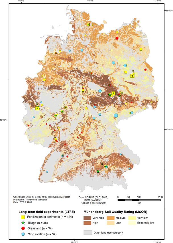
number of LTFEs at one place. LTFEs at one place.
SOIL, 6, 579–596, 2020 https://doi.org/10.5194/soil-6-579-2020M. Grosse et al.: Long-term field experiments in Germany: classification and spatial representation 587
Table 3. Climatic water balance of the growing season (CWBg)
classification of agricultural area used for grassland in Germany and
the number and share of the LTFEs on grassland in each CWBg
class.
CWBg Range Agricultural Grassland
class [mm yr−1 ] area (grassland) LTFEs (n = 34)
Area Share Number Share
[ha] [%] [%]
1 < −150 599 247 14 6 18
2 −150 to < −50 792 064 18 3 9
3 −50 to < 50 1 420 319 33 15 44
4 50 to < 150 398 496 9 7 21
5 150 to < 300 1 009 952 23 3 9
6 300 to < 500 137 968 3 0 0
7 > 500 0 0 0 0
any grassland LTFEs. CWBg classes 2 and 5 are underrepre-
sented by grassland LTFEs, while CWBg classes 3 and 4 are
overrepresented by grassland LTFEs. Overall and compared
to the arable land area, the three driest CWBg classes 1–3
represent only 65 % of the grassland area and host 71 % of
the grassland LTFEs.
3.2.2 Geospatial analysis of LTFEs in relation to the Figure 6. Share of arable area and LTFEs in every climatic water
Müncheberg Soil Quality Rating (MSQR) balance and Müncheberg Soil Quality Rating combination.
distribution
An overview of the distribution of the MSQR classes and of
3.2.3 Geospatial analysis of LTFEs in relation to the
LTFEs in Germany is given in Fig. 5. Soils classified as “very
combined CWBg and MSQR distribution
high” are located mainly in the central part of Germany. Soils
classified as “high” exist in the central part and in the south of The share of the arable area in Germany and the share of
Germany as well as in some smaller areas in the northwestern LTFEs on arable land in every CWBg–MSQR intersection
region of Germany, including the coastlines. Soils classified are compared (Fig. 6). According to this analysis, in the
as “low” and “medium” are predominant in the northern part MSQR class extremely low, the share of LTFEs matches the
of Germany but also exist in some areas in the middle and share of arable land area in each CWBg class. In the other
south of Germany. Soils classified as “very low” mainly ex- MSQR classes, CWBg class 1 is overrepresented by LTFEs
ist in northeastern Germany. Soils classified as “extremely compared to the respective land area. Thus, regarding cli-
low” exist mainly in small areas of mid-east, mid-west and mate, the distribution of LTFEs is biased towards dry areas
northwest Germany (Fig. 5). with the very low CWBg class 1. The reason for this bias
The classification of the agricultural area into the six is probably because most of these LTFEs are located in the
MSQR classes (Table 4) is as follows: the largest share region surrounding Berlin and the region Bad Lauchstädt–
(28 %) of agricultural area is classified as medium. The Halle–Seehausen, which are both historical agricultural re-
smallest shares are classified as extremely low (6 %) and search areas.
very high (10 %). Medium shares are classified as very low In CWBg class 2, the distribution of LTFEs is biased
(17 %), low (21 %) and high (18 %). LTFE sites exist in all towards high and very high MSQR classes. This result is
MSQR classes, and overall, the distribution of the LTFE sites mainly caused by the sites Bonn, Braunschweig, Gießen and
follows a similar pattern as that of the MSQR classes, with Göttingen.
the exception of a bias towards the high MSQR class. CWBg class 3 is underrepresented by LTFEs in the MSQR
classes of very low, low, medium and high.
CWBg classes 4 and 5 are rather adequately represented
by LTFEs in every MSQR class. However, these CWBg
classes rarely exist in Germany.
For the landscape approach proposed in this paper, more
LTFEs would be required in areas with CWBg class 3 on
https://doi.org/10.5194/soil-6-579-2020 SOIL, 6, 579–596, 2020588 M. Grosse et al.: Long-term field experiments in Germany: classification and spatial representation
Table 4. Müncheberg Soil Quality Rating (MSQR) classification of arable land in Germany and the number and share of the different LTFE
types in each MSQR class.
MSQR Agricultural LTFEs total (arable Fertilization Tillage Crop rotation
area land) (n = 169) LTFEs∗ (n = 123) LTFEs∗ (n = 38) LTFEs∗ (n = 32)
Area Share Number Share Number Share Number Share Number Share
[ha] [%] [%] [%] [%] [%]
Extremely low 705 687 6 9 5 5 4 4 11 3 9
Very low 2 149 584 17 29 17 22 18 5 13 5 16
Low 2 656 535 21 18 11 13 11 3 8 1 3
Medium 3 532 109 28 32 19 28 23 6 16 4 13
High 2 182 221 18 45 27 28 23 13 34 11 34
Very high 1 181 237 10 36 21 27 22 7 18 8 25
∗ Multiple nominations possible.
Table 5. Clay content classification according to ESDAC (2020) of arable land in Germany and the number and share of the different LTFE
types in each clay content class.
Clay content Range Agricultural LTFEs total (arable Fertilization Tillage Crop rotation
class [%] area (arable) land) (n = 169) LTFEs∗ (n = 124) LTFEs∗ (n = 38) LTFEs∗ (n = 32)
Area Share Number Share Number Share Number Share Number Share
[ha] [%] [%] [%] [%] [%]
1 0 to 5 1 748 393 14 25 15 19 15 6 16 3 9
2 6 to 10 2 404 798 19 24 14 19 15 6 16 3 9
3 11 to 16 2 265 517 18 29 17 20 16 5 13 4 13
4 17 to 19 1 523 493 12 42 25 37 30 6 16 6 19
5 20 to 21 1 179 602 9 15 9 12 10 2 5 8 25
6 22 to 24 1 553 463 12 20 12 11 9 5 13 6 19
7 25 to 27 1 097 725 9 4 2 1 1 3 8 1 3
8 28 to 98 1 082 066 8 10 6 5 4 5 13 1 3
Table 6. Clay content classification according to ESDAC (2020) of 3.2.4 Geospatial analysis of LTFE in relation to the clay
agricultural area used for grassland in Germany and the number and content distribution
share of the LTFEs on grassland in each clay content class.
According to Table 5, every clay content class is represented
Clay con- Range Agricultural area Grassland by LTFEs on arable land. Clay content class 4 (17 % to 19 %
tent class [%] (grassland) LTFEs (n = 34) clay content) is overrepresented by LTFE, while the high clay
content classes 7 (25 % to 27 % clay content) and 8 (28 % to
Area Share Number Share
98 % clay content) are underrepresented, especially by fertil-
[ha] [%] [%]
ization and crop rotation LTFEs.
1 0 to 5 715 137 11 3 9 Among grassland, LTFEs in clay content class 3 (11 % to
2 6 to 10 941 166 15 5 15 16 % clay content) are completely missing (Table 6). The
3 11 to 16 952 126 15 0 0 clay content classes 5 (20 % to 21 % clay content), 6 (22 %
4 17 to 19 821 432 13 4 12 to 24 % clay content) and 7 (25 % to 27 % clay content) are
5 20 to 21 710 826 11 6 18
overrepresented by grassland LTFEs, while the other clay
6 22 to 24 978 366 15 5 15
7 25 to 27 651 066 10 8 24
content classes are rather equally represented.
8 28 to 98 639 561 10 3 9 Franko et al. (2011) found in their analysis of 40 LTFEs for
the validation of a simplified carbon balance model, derived
from the CANDY model, that more experimental results on
clay soils would be required. This could be confirmed for
soils classified as MSQR very low, low, medium and high LTFEs on arable land in this study.
and in areas with CWBg class 2 on soils classified as MSQR
classes very low, low and medium.
SOIL, 6, 579–596, 2020 https://doi.org/10.5194/soil-6-579-2020M. Grosse et al.: Long-term field experiments in Germany: classification and spatial representation 589 4 Conclusions To obtain adequate information about each CWBg, MSQR and clay content class through LTFEs, more LTFEs would have to be established. However, nearly every class is repre- sented by at least some LTFEs. For the joint analysis, there are other more important constraints: data are not easy to ac- cess, and sometimes the older data are not digitized. Here, BonaRes offers great opportunities through the provision of support for data preparation and through the establishment of a common database. We hope that this great opportunity will be frequently used by LTFE holders in future. https://doi.org/10.5194/soil-6-579-2020 SOIL, 6, 579–596, 2020
590                           M. Grosse et al.: Long-term field experiments in Germany: classification and spatial representation

Appendix A

Table A1. IDs of all long-term field experiments, their original name, their location, their CWBg class (1 May to 31 October), their MSQR
class and their thematic classification. The institution address is indicated by a number and given below the table. More details about the
LTFEs can be found in the complete dataset (Grosse and Hierold, 2019).

  ID   LTFE name                                                     Place of LTFE                  Address    CWBg     MSQR            Thematic
                                                                                                 (see below)    class   class           classification
  Field crop LTFE
  1    Bodenbearbeitungsversuch Dichtelbach                          Dichtelbach (Hunsrück)               1        3    very low        Tillage
  2    Bodenbearbeitungsversuch Welschbillig                         Welschbillig (Eifel)                 1        3    very low        Tillage
  3    Bodenbearbeitungsversuch Wintersheim                          Wintersheim (Rheinhessen)            1        1    very high       Tillage
  4    Statischer Düngungsversuch V120                               Bad Lauchstädt                       2        1    very high       Fertilization
  5    Erweiterter Statischer Düngungsversuch V120a                  Bad Lauchstädt                       2        1    very high       Fertilization
  6    Modellversuch Stalldungsteigerung                             Bad Lauchstädt                       2        1    very high       Fertilization
  7    Bracheversuch V505a                                           Bad Lauchstädt                       2        1    very high       Other
  8    Statischer Stickstoffdüngungsversuch                          Bad Salzungen                        3        2    very low        Fertilization
  9    Statischer Kalkdüngungsversuch M16                            Bad Salzungen                        3        2    very low        Fertilization
  11   Dauerdüngungsversuch L28                                      Bad Salzungen                        3        2    very low        Fertilization
  13   Statischer Dauerversuch Bodennutzung (BDa_D3)                 Berlin-Dahlem                        4        1    very low        Fertilization/Tillage/Crop rotation
  14   Internationaler Organischer-Stickstoff-Dauerdüngungsversuch   Berlin-Dahlem                        4        1    very low        Fertilization
       (BDa_IOSDV)
  15   Agrarmeteorologisches Intensivmessfeld (BDa_E-Feld)           Berlin-Dahlem                        4        1    very low        Other
  16   Bodenbearbeitungsversuch (Versuchsfeld Westerfeld)            Bernburg-Strenzfeld                  5        1    very high       Tillage
  17   Anbausysteme-Vergleich                                        Bernburg-Strenzfeld                  6        1    very high       Crop rotation/Other
  18   Grundbodenbearbeitung und Distelbekämpfung, ökologisch        Bernburg-Strenzfeld                  6        1    very high       Tillage/Crop rotation/Other
       viehlos
  19   Bodenbearbeitung und Bestelltechnik in der Fruchtfolge        Bernburg-Strenzfeld                  6        1    very high       Tillage/Other
  20   Dauerdüngungsversuch Dikopshof                                Wesseling-Dikopshof                  7        2    very high       Fertilization/Crop rotation
  21   Selektions-Dauerversuch SDV                                   Klein Altendorf                      7        3    very high       Crop rotation
  22   Strohdüngung zu Getreide                                      Meckenheim                           7        2    very high       Fertilization
  23   Phosphatformenversuch                                         Meckenheim                           7        2    very high       Fertilization
  24   Organische Düngung                                            Meckenheim                           7        2    very high       Fertilization
  25   Strohdüngung mit Faulschlamm                                  Meckenheim                           7        2    very high       Fertilization
  26   Kaliformenversuch                                             Meckenheim                           7        2    very high       Fertilization
  27   Strohdüngung mit verschiedenen N-Formen                       Meckenheim                           7        2    very high       Fertilization
  28   Phosphatvorratsdüngung                                        Meckenheim                           7        2    very high       Fertilization
  29   Kalkversuch mit Spurenelementen                               Meckenheim                           7        2    very high       Fertilization
  30   Versuch mit Faulschlämmen                                     Meckenheim                           7        2    very high       Fertilization
  31   Dauerdüngungsversuch                                          Bonn-Poppelsdorf                     7        2    high            Fertilization/Crop rotation
  33   Langzeit Düngungsversuch (FV4)                                Völkenrode                           8        2    very high       Fertilization/Tillage
  34   C-Dauerfeldversuch (FV36)                                     Völkenrode                           8        2    very high       Fertilization
  35   Südfeld-Düngungsversuch                                       Völkenrode                           9        2    very high       Fertilization
  36   Folgenabschätzung der Wechselwirkung von Fruchtfolge, Dün-    Dahnsdorf                           10        1    high            Other
       gung und Pflanzenschutz
  37   Langzeit-Düngungsversuch                                      Darmstadt                           11        2    low             Fertilization
  38   Klassischer DFV (4b2, organische und mineralische Düngung)    Dülmen                              12        3    medium          Fertilization
  39   Dauerdüngungsversuch IOSDV                                    Dülmen                              12        3    medium          Fertilization
  40   Zuckerrübenfruchtfolgeversuch                                 Etzdorf                             13        1    very high       Fertilization/Crop rotation/Other
  41   Dauerdüngungsversuch (Zuckerrübenmonokultur)                  Etzdorf                             13        1    very high       Fertilization/Crop rotation
  42   Dauerdüngungsversuch Getreide (Getreidedauerversucht)         Etzdorf                             13        1    very high       Fertilization/Crop rotation
  43   Dauerdüngungsversuch Getreide (Getreidedauerversuch zur       Etzdorf                             13        1    very high       Fertilization/Crop rotation
       Bekämpfung der Halmbruchkrankheit)
  44   N-Formen-Versuch                                              Freising                            14        4    high            Fertilization/Crop rotation
  45   P-Düngung                                                     Freising                            14        4    high            Fertilization
  47   Stroh/Stalldung-Fruchtfolge                                   Freising                            14        4    high            Fertilization
  48   N-Düngung/Fruchtfolge                                         Freising                            14        4    high            Fertilization
  49   N-Steigerung mit Kalkstickstoff                               Freising                            14        4    high            Fertilization
  50   Versuch 020 N-Formen-Versuch                                  Freising                            14        3    high            Fertilization
  51   Bodenbearbeitungsversuch Südzucker                            Friemar                             15        2    very high       Tillage
  52   Erschöpfungsversuch (EV)                                      Gießen                              16        2    low             Fertilization
  53   Kalkdüngungsversuch                                           Gießen                              16        2    high            Fertilization
  54   Dauerversuch Biologische Stickstofffixierung (BSG)            Gießen                              16        2    high            Fertilization/Crop rotation
  55   Ökologischer Ackerbauversuch Gladbacherhof                    Villmar                             17        2    extremely low   Fertilization/Tillage/Crop rotation
  56   Bodenbearbeitungsversuch Hohes Feld                           Nörten-Hardenberg                   18        3    high            Tillage
  57   Garte-Süd-Bodenbearbeitung (Reinshof)                         Göttingen                           18        2    very high       Tillage
  58   Garte-Nord-Bodenbearbeitung (Reinshof)                        Göttingen                           18        2    high            Crop rotation
  59   Langzeitversuch zur P- und K-Düngung auf dem Reinshof         Nörten-Hardenberg                   19        2    high            Fertilization
  60   Bodenbearbeitungsversuch Südzucker                            Grombach                            15        3    high            Tillage
  61   Kastenparzellenversuch Sandboden / Lehmboden / Tonboden       Großbeeren                          20        1                    Fertilization

SOIL, 6, 579–596, 2020                                                                                             https://doi.org/10.5194/soil-6-579-2020
M. Grosse et al.: Long-term field experiments in Germany: classification and spatial representation 591
Table A1. Continued.
ID LTFE name Place of LTFE Address CWBg MSQR Thematic
(see below) class class classification
62 PK-Mangelversuch Groß Gerau 16 1 very low Fertilization
63 Dauerfeldversuch P60 Groß Kreutz 21 1 low Fertilization
64 Dauerfeldversuch M4 Groß Kreutz 21 1 very low Fertilization
65 Versuchsfeld der Versuchsstation Groß Lüsewitz Groß Lüsewitz 22 2 very low Other
66 Ewiger Roggen Halle 23 1 medium Fertilization/Crop rotation
67 Schmalfuss’scher Dauerversuch, Feld A, Kalkdüngung Halle 23 1 very high Fertilization
68 Schmalfuss’scher Dauerversuch, Feld C, Kaliumdüngung Halle 23 1 very high Fertilization
69 Schmalfuss’scher Dauerversuch, Feld D, Phosphordüngung Halle 23 1 very high Fertilization
70 Organische Düngung (Feld F) Halle 23 1 very high Fertilization
71 Dauerfeldversuch ”Bodenfruchtbarkeit” Hennef 7 3 very high Fertilization
72 Dauerversuch Düngung-Fruchtfolge Renningen 24 4 medium Fertilization/Crop rotation
73 Versuch zur Bodenbearbeitung Renningen 24 3 low Tillage
74 Dauerdüngungsversuch Hohenschulen 25 3 high Fertilization
75 Stickstoffversuch ”Decline-Versuch” Hohenschulen 25 3 medium Fertilization
76 Fruchtfolgeversuch Hohenschulen 25 3 medium Fertilization/Crop rotation
77 N-Düngung zu Wintergerste Hohenschulen 25 3 medium Fertilization
78 Düngerartenvergleich (Versuch I) Lauterbach 23 5 medium Fertilization/Crop rotation
79 Kombinationswirkung (Versuch II) Lauterbach 23 5 very low Fertilization
80 Nährstoffverhältnisversuch Limburgerhof/Bruch 26 1 very low Fertilization
81 Feldwirtschaftsversuch Limburgerhof/Bruch 26 1 low Fertilization
82 Nährstoffmangelversuch Limburgerhof 26 1 low Fertilization
83 WW-Fruchtfolgeversuch Ludwigshafen/Ruchheim 26 1 low Fertilization/Crop rotation/Other
84 Bodenbearbeitungsversuch Ludwigshafen/Ruchheim 26 1 high Fertilization/Tillage
85 Bodenbearbeitungsversuch Lüttewitz 15 2 high Tillage
86 Dauerdüngungsversuch L28 Methau 27 3 high Fertilization
87 Dauerdüngungsversuch (V140) Müncheberg 28 1 low Fertilization
88 Bodenbearbeitung (V760) Müncheberg 28 1 low Tillage
89 Modellbetrieb Organischer Landbau, Felder 931–934 Müncheberg 28 1 low Other
90 Kalium-Steigerungsversuch Höckelheim/Südniedersachsen Northeim/Höckelheim 29 2 low Fertilization
91 P-Düngung auf Sandmischkultur Oldenburg/Friesoythe 29 3 medium Fertilization
92 Bodenbearbeitung/Fruchtfolge Oldenburg/Friesoythe 18 3 extremely low Tillage/Crop rotation
93 Bodenbearbeitung Oldenburg/Friesoythe 18 3 extremely low Tillage
94 Internationaler Organischer Stickstoffdüngungs-Versuch Oldenburg 30 3 extremely low Fertilization
(IOSDV)
96 Dauerversuch “Auswirkung von Daueranbau” Puch 31 5 extremely low Crop rotation
97 Verbesserte Dreifelderwirtschaft Puch 31 5 high Crop rotation
98 Getreide/Mais Fruchtfolge Puch 31 5 high Crop rotation
99 Einfluss von Grundbodenbearbeitung Puch 31 5 high Tillage
100 Internationaler Organischer Stickstoffdüngungs-Versuch Puch 31 5 high Fertilization
(IOSDV)
101 Internationaler Organischer Stickstoffdüngungs-Versuch Rauischholzhausen 16 2 high Fertilization
(IOSDV)
102 Organische Düngung / Stalldung Schafpferchversuch Rauischholzhausen 16 2 high Fertilization
103 Gründüngung / Strohdüngungsversuch Rauischholzhausen 16 2 high Fertilization
104 Bilanzversuch Kastenanlage Rauischholzhausen 16 2 high Fertilization
105 Wirkungen differenzierter Bodenbearbeitungssysteme im Scheyern 32 4 high Fertilization/Tillage/Crop rotation
Dauerversuch Scheyern
106 Fruchtfolgedüngungsversuch Seehausen 23 1 high Fertilization/Crop rotation
107 Konzentrationsversuch Seehausen 23 1 high Crop rotation
108 Düngungs-Kombinationsversuch Seehausen (F1-70) Seehausen 23 1 high Fertilization
109 Bodenbearbeitungsversuch Seehausen 23 1 high Tillage
110 Gülledauerversuch Seehausen 23 1 high Fertilization
111 Bodenfruchtbarkeitsversuch Seehausen 23 1 high Fertilization/Tillage
112 Internationaler Organischer Stickstoffdüngungs-Versuch Speyer 33 2 high Fertilization/Tillage
(IOSDV)
113 Humusversuch Speyer 33 2 medium Fertilization/Other
114 Kali-Magnesium-Kalk-Versuch Speyer 33 2 medium Fertilization
115 Klärschlammversuch Speyer 33 2 medium Other
116 Bracheversuch Speyer 33 2 medium Other
117 Dauerdüngungsversuch L28 Spröda 27 1 medium Fertilization
119 Düngungs- und Beregnungsversuch (Thy_D1) Thyrow 34 1 high Fertilization/Other
120 Stroh- und N-Düngung in Fruchtfolgen mit unterschiedlichem Thyrow 34 1 very low Fertilization/Crop rotation
Getreideanteil (Thy_D5)
121 Statischer Nährstoffmangelversuch (Thy_D41) Thyrow 34 1 very low Fertilization
122 Nährstoffmangelversuch Winterroggen Monokultur (Thy_D42) Thyrow 34 1 very low Fertilization
123 Statischer Bodenfruchtbarkeitsversuch (Thy_D6) Thyrow 34 1 very low Fertilization
125 Strohdüngungsversuch (Thy_D2) Thyrow 34 1 very low Fertilization
136 Modellbetrieb Organischer Landbau, Felder 901–904 Müncheberg 28 1 very low Other
137 Statischer Dauerfeldversuch ”organisch-mineralische Großbeeren 20 1 very low Fertilization
N-Düngung”
138 Versuch zur Bodenbearbeitung Schönberg 35 3 low Tillage
139 Gehölzhäckselapplikation Schönberg 35 3 very low Other
140 Versuch 700 (Reduzierte Bodenbearbeitung) Schönberg 35 3 extremely low Tillage
https://doi.org/10.5194/soil-6-579-2020 SOIL, 6, 579–596, 2020You can also read